4.2.1. Bank Erosion Correlation to BEHI
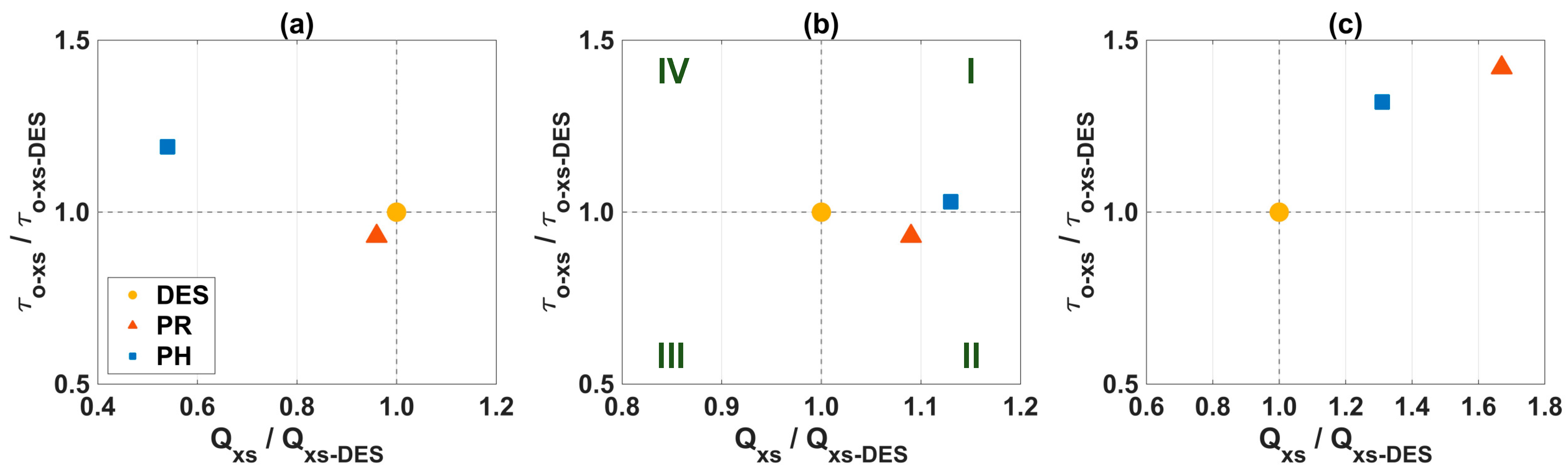
Previous analyses indicated that the applied stresses were affected by the local degree of measured morphodynamic adjustment (
Figure 5). If changes associated with bank properties and conditions were not as pronounced, this implied that a given cross-section would experience more or less erosion depending primarily on the trajectory of the adjustment (
Figure 7). Physically, BEHI scores (
Table 3) did not provide a quantitative understanding of the erodibility phenomenon, neither in terms of resisting (e.g.,
τc and
kd), nor applied (e.g.,
τo) forces; rather, they only provided a qualitative assessment of how likely a bank was to undergo erosion. In contrast, BSTEM erosion predictions were based on the excess shear stress acting on banks, balancing resisting and applied forces as dictated by cross-sectional geometry, soil properties, and flow characteristics. A process-based representation such as this acknowledged that erodibility was a compound phenomenon, in which highly erodible banks were necessary, but not sufficient, as applied stresses capable of generating erosion were also required. In the BANCS model, the compound phenomenon was considered through erodibility curves that used both BEHI and NBS as predictor variables [
25]. However, BEHI scores had also been applied as stand-alone parameters to estimate bank erosion rates (e.g., [
23,
52,
64]).
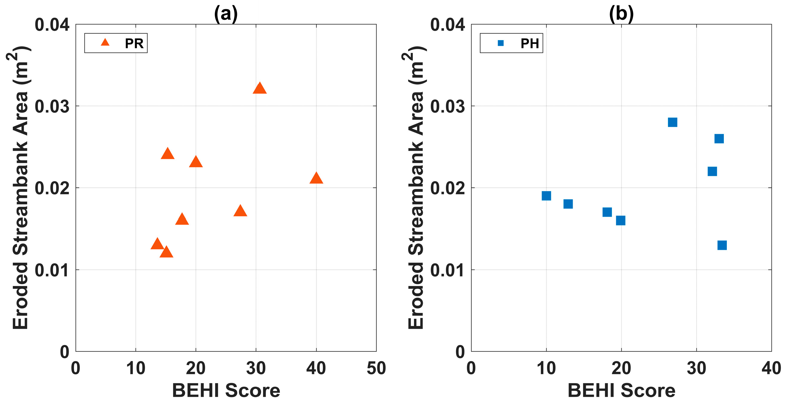
At the local-scale, the Pearson’s correlation coefficient (
ρcoeff) [
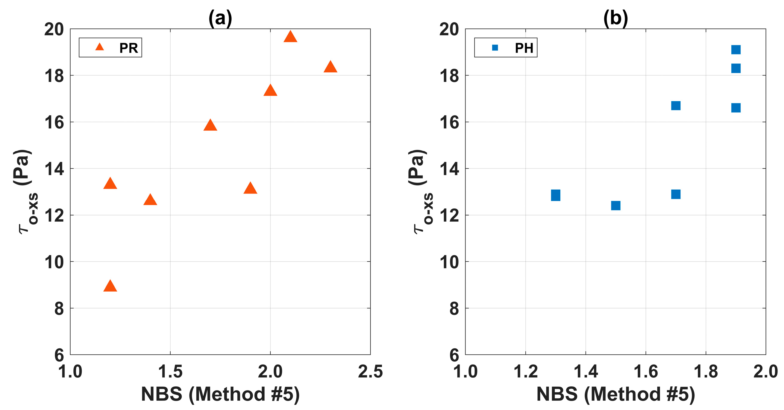
62] was calculated to examine the linear dependence between BSTEM process-based predictions of eroded bank area at each cross-section and form-based BEHI scores for bank erosion potential. These data are shown in
Figure 8, where the eroded bank area represented the detached area in the direction perpendicular to the flow normalized by the input duration of flow. Results corresponded to
ρcoeff of 0.47 for the PR geometry (
Figure 8a) and
ρcoeff of 0.29 for the PH geometry (
Figure 8b). Statistically, the low values of
ρcoeff indicated that the correlation between these variables was not strong, meaning that the eroded bank area computed by BSTEM did not consistently increase with increasing BEHI scores. Results in
Figure 8 suggested that BEHI scores were not able to capture the measured morphodynamic adjustments following the severe floods in 2018. Even though the correlation was not strong for the PR geometry with
ρcoeff = 0.47, it significantly deteriorated for the PH geometry with
ρcoeff = 0.29. This trend suggested that BEHI scores may not have the resolution to accurately describe these types of short-term morphodynamic adjustments.
4.2.2. Volumetric Amount
Volumetric amounts of geomorphic change were calculated based on the predictions from BANCS, BSTEM, HEC-RAS 1D, and HEC-RAS 1D & BSTEM. Results are presented in
Table 7 for the DES, PR, and PH geometries. These results corresponded to cumulative volumetric amounts of geomorphic change across the eight cross-sections as dictated by morphodynamic processes included in each modeling approach. Volumetric amounts from BANCS were computed using erosion rates (which were converted into volumes based on bank height and length) from the North Carolina Bank Erodibility Curve [
53] that applied BEHI and NBS (Method #5) as predictor variables. BANCS volumetric amounts were given on an annual basis, accounted only for bank erosion, and were based on the evaluated bank (i.e., RB or LB) at the eight cross-sections. Furthermore, it should be noted that BANCS volumetric amounts were computed using NBS Method #5 and could change depending on the applied method (e.g., [
14,
25,
50]). BSTEM volumetric amounts were calculated using eroded bank areas that were converted into volumes based on bank length, as well as dislodged sediment volumes due to bank geotechnical failure. Similar to BANCS predictions, BSTEM volumetric amounts were based on the evaluated bank (i.e., RB or LB) at the eight cross-sections. For HEC-RAS 1D, volumetric amounts were based on predicted changes over entire cross-sections along the study reach, either by accounting only for bed material transport (i.e., HEC-RAS 1D) or by adding the contribution of bank erosion and failure (i.e., HEC-RAS 1D & BSTEM). In contrast to BANCS predictions, volumetric amounts of geomorphic change from BSTEM and HEC-RAS 1D were given on an event basis.
At a local scale, BANCS and BSTEM predictions indicated that a process-based approach to directly account for bank failure increased the volumetric amount by an order of magnitude (
Table 7). In the BANCS model, the potential for bank failure was indirectly considered through metrics that included bank height and angle as part of BEHI assessments. The volumetric amount varied from −2.4 m
3 to −18.6 m
3 for the PR geometry, and from −2.7 m
3 to −26.7 m
3 for the PH geometry (where the negative sign indicated erosion). Beyond the driving morphodynamic processes, note the different time scales associated with BANCS and BSTEM results. BANCS volumetric amounts were given on an annual basis following the time resolution of the applied bank erodibility curve. In general, as discussed by Bigham et al. [
25], available erodibility curves show marked variability in terms of number of sites, years of measurements, and range of discharges that occurred during measurements. Hence, the accuracy of BANCS predictions is closely related to the amount and quality of data that were used to develop a specific curve. For North Carolina, the applied bank erodibility curve was based on measurements at 20 cross-sections distributed across six stream reaches that represented various land uses [
53,
65]. According to the summary provided in Bigham et al. [
25], the measurements corresponded to one year of data with no reported range of discharges. Doll et al. [
53] noted this limitation, indicating the need for expanding the North Carolina Bank Erodibility curve by lengthening the monitoring period and increasing the range of discharges experienced during measurements.
Depending on the frequency of measurements, the contribution of severe or rare floods may not be accurately captured by erodibility curves developed from the BANCS methodology. As shown by the PH geometry results, these types of events can have a pronounced impact on the stream’s water conveyance and sediment transport capacity (
Figure 7). Similar findings were reported by Dave et al. [
66] in the Cedar River, Nebraska, USA, where 29% of the bank retreat experienced over a period of 10 years was caused by a single flood following a dam breach. These observations suggest that predictions from the BANCS model may be more suitable for streams that show limited variability in flow distribution where a single discharge is more representative of reach-averaged conditions, unless data for constructing bank erodibility curves are collected over an extended period and at a higher frequency to capture the contribution of severe or rare floods. BSTEM volumetric amounts, alternatively, can account for the process-based response of streams to individual floods (i.e., event basis), which is fundamental to improve our understanding of how non-stationary climatic conditions affect geomorphic change [
67]. In this study, for example, BSTEM results for the PR and PH geometries indicated that a single bankfull flood event had the capacity to generate higher volumetric amounts than those predicted by BANCS on an annual basis (
Table 7).
Among process-based models, BSTEM and HEC-RAS 1D predictions indicated that considering bed material transport increased the volumetric amount by two orders of magnitude (
Table 7). Based on HEC-RAS 1D, the volumetric amount varied from −18.6 m
3 to +1374.2 m
3 for the PR geometry, and from −26.7 m
3 to +1138.2 m
3 for the PH geometry (where the positive sign indicated deposition). The pronounced variation in magnitude showed that bed material transport dominated geomorphic changes along the sand-bed study reach. Additionally, changes in sign denoted a different stream response from erosion (as predicted by BSTEM) to deposition (as predicted by HEC-RAS 1D). Physically, these observations suggested that the stream did not have enough bed material transport capacity. Numerically, they emphasized the need for applying process-based, reach-scale models to analyze streams with highly mobile bed material.
Among reach-scale models, HEC-RAS 1D and HEC-RAS 1D & BSTEM predictions indicated that considering bed material transport coupled with bank erosion and failure produced the highest volumetric amounts of geomorphic change (
Table 7). The volumetric amount varied from +1374.2 m
3 to +2043.6 m
3 for the PR geometry, and from +1138.2 m
3 to +1726.7 m
3 for the PH geometry. Physically, results suggested that bank retreat led to cross-sectional widening, which in turn led to a reduction in water conveyance and sediment transport capacity, resulting in more pronounced deposition levels. Moreover, feedback effects between bed material transport and bank retreat had a non-linear impact on the magnitude of volumetric amounts of geomorphic change. When comparing HEC-RAS 1D and HEC-RAS 1D & BSTEM predictions, the volumetric amount increased by approximately 50% for both geometries, which represented an increase in volume that was much larger than the stand-alone amount predicted by BSTEM. Numerically, these observations suggested that process-based, reach-scales models that simultaneously account for bed material transport and bank retreat should be used to analyze streams with highly erosional cross-sectional boundaries.
Lastly, for the DES geometry, BSTEM predicted a volumetric amount of −2.6 m3, which was driven by erosion given that no bank was found geotechnically unstable or conditionally stable (i.e., FS > 1.3 along the study reach). Similar to the PR and PH geometries, the volumetric amount increased to −463.3 m3 when accounting for bed material transport (i.e., HEC-RAS 1D) and to −759.9 m3 when adding the contribution of bank retreat (i.e., HEC-RAS 1D & BSTEM). However, as denoted by the negative sign, HEC-RAS 1D and HEC-RAS 1D & BSTEM results showed a different stream response in the case of the DES geometry. Physically, the DES geometry results suggested that initial bed erosion led to incision, localized steeper bottom slopes, and higher and unstable banks, which eventually led to bank failure, widening, and bed deposition. These results emphasized the importance of adequate model selection both, in terms of formulation and scale, to capture dominant morphodynamic processes and improve the quantitative understanding of stream response to restoration efforts.

 ,
, 


