Article

Science-Based IWRM Implementation in a Data-Scarce Central Asian Region: Experiences from a Research and Development Project in the Kharaa River Basin, Mongolia

1
Department Aquatic Ecosystem Analysis and Management, Helmholtz Centre for Environmental Research, Magdeburg 39114, Germany
2
Department Ecohydrology, Leibniz Institute of Freshwater Ecology and Inland Fisheries, Berlin 12587, Germany
3
Department of Urban Water and Waste Management, Duisburg-Essen University, Essen 45141, Germany
4
Department of Geography, Heidelberg University, Heidelberg 69120, Germany
5
Institute of Geography-Geoecology, Mongolian Academy of Sciences, Ulaanbaatar 15170, Mongolia
6
Center for Environmental Systems Research, Kassel University, Kassel 34109, Germany
*
Author to whom correspondence should be addressed.
Water 2015, 7(7), 3486-3514; https://doi.org/10.3390/w7073486
Submission received: 27 March 2015 / Revised: 27 May 2015 / Accepted: 12 June 2015 / Published: 1 July 2015

Abstract

:
Mongolia is not only a water-scarce but also a data-scarce country with regard to environmental information. At the same time, regional effects of global climate change, major land use changes, a booming mining sector, and growing cities with insufficient and decaying water and wastewater infrastructures result in an increasingly unsustainable exploitation and contamination of ground and surface water resources putting at risk both aquatic ecosystems and human health. For the mesoscale (≈15,000 km2) model region of the Kharaa River Basin (KRB), we investigated (1) the current state of aquatic ecosystems, water availability and quality; (2) past and expected future trends in these fields and their drivers; (3) water governance structures and their recent reforms; and (4) technical and non-technical interventions as potential components of an integrated water resources management (IWRM). By now, the KRB is recognized as one of the most intensively studied river basins of the country, and considered a model region for science-based water resources management by the Mongolian government which recently adopted the IWRM concept in its National Water Program. Based on the scientific results and practical experiences from a six-year project in the KRB, the potentials and limitations of IWRM implementation under the conditions of data-scarcity are discussed.

1. Introduction

Integrated Water Resources Management (IWRM), which Global Water Partnership (GWP) defined as the “process which promotes the coordinated development and management of water, land, and related resources, in order to maximize the resultant economic and social welfare in an equitable manner without compromising the sustainability of vital ecosystems” [1] is considered as the most appropriate general concept for water management, specifically for developing and transformation countries [2,3]. The United Nations have recommended IWRM as a straightforward approach for meeting the Millennium Development Goals in their World Water Development Report (2006) [4,5]. The concept of IWRM has gained wide acceptance in the majority of countries worldwide in the last 20 years, but the actual implementation of IWRM is lagging behind formal inclusion into policies, strategies and laws [6,7].
The broadness of GWP’s IWRM definition makes it a framework for normative and strategic water management that leaves space for many different types of approaches at the operational level adapted to the respective situation in specific countries or regions [3,8]. However, the concept has also been heavily criticized for its vagueness. Since the definition tries to be as holistic as possible, it incorporates both sustainable development and cross-sectorial planning simultaneously, both of which are extremely complex and comprehensive in themselves [9]. Hering and Ingold [10] have doubts on the overall feasibility and implementabilty of IWRM, which from their point of view is lacking methodology. Biswas [11] considers IWRM an “undefinable and unimplementable concept” that is politically preferable simply because of its vagueness that allows people to continue with what they had always done by only renaming their process after the current politically correct terms.
The sufficient access to comprehensive and reliable data is a prerequisite for the transition from IWRM concepts to actual implementation. The support of all engaged parties with unbiased and trustworthy information can only be delivered by independent science [12]. Unfortunately, developing and transition countries are often not able to operate independent research and monitoring due to lacking financial, infrastructural, or educational capacities. Therefore they often have to rely on financial support from external donors and/or data collected in the context of international collaborations. While this brings a risk of bias, there is also an opportunity for science to contribute the required expertise and give a stimulus to necessary stakeholder dialogues [2,4].
Recently, the ecosystem services (ESS) concept has been proposed as a suitable basis for prioritizing decisions at the river basin level [13,14]. However, the inclusion of ecosystem services into IWRM processes requires a sound knowledge of interactions between societal changes, terrestrial ecosystems, and water resources. In particular, the ESS approach is based on an estimation of incomes and costs linked to the utilization and management of water [15]. This is not possible without sufficient data on the water cycle, aquatic ecosystems and the direct or indirect socioeconomic benefits obtained, as well as investments needed to protect water resources.
Since 2004, the Mongolian government has gradually adopted the IWRM concept as the guiding principle for national water policy and designated 29 river basins of national importance, for which river basin management plans (RBMPs) are to be developed [16]. The resulting plans are expected to fulfill five main tasks: (1) providing an inventory and characterization of water bodies within the river basin; (2) preventing potential water scarcity; (3) protecting water resources against pollution; (4) allocating water resources in the most efficient way and (5) increasing water availability for domestic and commercial use. The implementation period of this first series of RBMPs was planned to be from 2015 to 2021 [17]. In addition to this, the Mongolian government has recently expressed a growing interest in the ESS concept. However, like in many other sparsely settled Central Asian countries that have recently undergone a profound socio-economic and political transition, data scarcity is a significant challenge for IWRM implementation in general and the formulation of RBMPs and assessment of ESS in particular [2,18].
Section 2 of this paper provides an overview on the study region and outlines the political and legal framework for water resources management. Section 3 analyzes the availability of relevant planning data for the conceptualization and implementation of river basin and urban water resources management strategies, including the role that a German-Mongolian research project on IWRM (Integrated Water Resources Management in Central Asia—Model Region Mongolia; IWRM MoMo) played for improving data availability. The lessons learnt for the implementability of IWRM under data scarcity and the role that research projects can play in this context are discussed in the conclusions (Section 5).

2. Characteristics of the Study Region

The following section provides a description of the KRB in order to characterize the regional framework conditions and key challenges for water resources management. With a total catchment area of 14,534 km2 the KRB is located north of the capital Ulaanbaatar, between latitudes 47°53′ N and 49°38′ N and longitudes 105°19′ E and 107°22′ E (see Figure 1). Key reasons for selecting the KRB as a model region for IWRM implementation in Mongolia included (1) environmental conditions typical for large parts of Central Asia; (2) strong gradients ranging from pristine streams to rivers under significant anthropogenic influences; (3) better-than-average data availability and (4) a central location within Mongolia which facilitates the transfer and duplication of measures [17].
Figure 1. Discharge and water quality monitoring sites by the Central Laboratory for Environment at the Institute of Meteorology, Hydrology and the Environment (IMHE) (yellow) and the Integrated Water Resources Management in Central Asia—Model Region Mongolia (IWRM MoMo) project (red) in the Kharaa River Basin.
Water 07 03486 g001

2.1. Water Availability and Its Determinants

The subarctic continental climate in the KRB is characterized by very cold winters with temperatures regularly reaching −40 °C and below, warm summers, and an average annual precipitation ranging from 250 mm in the downstream areas to 350 mm in the headwater areas. With regard to precipitation, there are large regional and interannual variations [16,19]. Under present climate and land cover conditions, on average more than 85% of the annual precipitation is lost due to evapotranspiration [19]. During summer (June–August), evapotranspiration in the semi-arid parts of the KRB even exceeds precipitation [20] and runoff generation is limited to strong summer rainfall events. In contrast, high summer evapotranspiration rates in the headwaters are usually surpassed by precipitation [20]. Thus, the mountainous parts of the catchment are important regions for freshwater generation. Further, common phenomena in the headwaters (and to a much smaller extent in the lowlands) are snow, permafrost, and aufeis [21,22] which contribute to river runoff, especially during snow melt in late spring or early summer. Climate variability and change are major drivers of hydrological trends in drylands [23,24]. In Mongolia, air temperature has increased by 1.8 °C since the 1940s [25], with spatially and temporally very different precipitation trends [26]. Until recently, practically no information was available for the headwater regions of the Kharaa. Climate scenarios predict a further increase of mean annual air temperature between 2.6 and 5.1 °C in Mongolia during the 21st century, while mean annual precipitation is expected to increase by 20 mm to 86 mm [27]. This may lead to a decrease in runoff via increased evaporation and an increased likelihood of water scarcity [26]. It should be noted though that there are high uncertainties regarding future precipitation, and projected precipitation changes between different climate models for the same scenario which are often larger than between two scenarios [28]. Some authors predict a significant decrease in precipitation in northern Mongolia from the 2070s onwards [29].
Land use changes may be of an even larger hydrological relevance than climate change, having effects on both water quantities and quality [16]. Causes of land use change include the extension of agricultural activities, rising livestock numbers, logging, wildfires, and mining. A massive expansion and intensification of the agricultural sector is currently being propagated by national agropolitics [30] and will lead to an increase in agricultural lands of 50% to 100%, with the side-effect of losses of large areas of natural vegetation and their related ecosystem services and functions [31]. However, observational studies that link land use, soil water balance, and evapotranspiration are limited to two point studies carried out during the IWRM MoMo project [20]. To our knowledge, there exist few studies in the substantially drier desert steppe ecotone in Inner Mongolia, China, which have focused on the effect of grazing on water and heat fluxes [32]. Therefore, little is known about the effects of land use change on evapotranspiration and freshwater generation under the given hydro-climatic conditions of the KRB.
Besides economic constraints [33], water availability is already the most important limiting factor for agricultural production. Thus, irrigation is seen as one solution to this dilemma, even more so because climate change leads to an increase in agricultural water demand in large parts of Mongolia, including parts of the KRB [28].
Between April 2000 and May 2012, a total of 200,000 ha, or about 14%, of the forested area in the KRB were affected by wildfires to various degrees. The majority of wildfires occurred in the boreal zone of the headwater regions, thereby altering almost pristine ecosystems that are of major importance for regulating the water regime [16,31,34]. The comparison of precipitation, soil moisture, and evapotranspiration on a steppe and shrubland site in the upper KRB revealed that there is only a negligible freshwater generation in sparsely vegetated steppe areas, whereas shrubland and boreal forests play an important role for water availability for the entire river basin [20]. The increasing scarcity of water will probably trigger competition between different water-users. Of particular relevance in this context is the booming mining sector. In the KRB, mining sites cover around 130 km2, but relatively little is known about their water consumption. Given the geological conditions and technology in use, a consumption of around 7 m3 of water per 1 m3 of ore seems to be realistic [35]. For Mongolia, Batsukh et al. [36] estimated the major water consumers to be mining (26.7% of abstractions), followed by domestic use (20.3%), livestock (20.2%), and irrigation (14.9%). By contrast, the Mongolian Ministry of Environment and Green Development estimated that 54% of the water is used for agriculture, 21% for municipalities, 15 % for industries (including mining), 10% for energy and 1% for other uses including tourism and transport. Even though the agricultural sector is currently (2010) the biggest water user, the projected water demand of the mining sector is supposed to exceed the water usage of agriculture until within the next decade [33].

2.2. Water Quality and Aquatic Ecosystem Status

The Kharaa River Basin is, by international standards, characterized by a relatively low population density (about 8 people/km2). Nevertheless, localized concentrations of population, an often poor state of urban wastewater infrastructures, high livestock densities in the riverine floodplains, and large-scale mining activities are potential threats to the aquatic ecosystems of the Kharaa. Among the key stressors affecting water quality and the aquatic ecosystem of the Kharaa are rising nutrient inputs, high fine sediment loads, the loss of habitat integrity of hyporheic and riparian zones, and mining-related influxes of toxic substances [16,37].
A state inventory for surface water in Mongolia conducted in 2003 showed that even though most rivers in the country were in relatively pristine condition, at least 23 rivers in eight provinces were morphologically changed and/or polluted due to mining activities [36], including the Kharaa-Orkhon-Selenga river system. Studies in the Kharaa and adjoining river basins show that gold mining is a major polluter [38,39,40,41] and that it drastically affects the ecology of diatom, macrozoobenthos, and fish communities [42,43]. Moreover, high concentrations of nutrients, boron, and a high electrical conductivity which were observed in several locations in the lower KRB are indications of groundwater contamination by improper wastewater disposal [33].
In recent years, increasing nutrient loads could be observed in the Kharaa River, with a considerable longitudinal deterioration of water quality. Results of nutrient emission modeling confirm that urban settlements are the main sources for nitrogen and phosphorus emissions [44,45,46]. Since only 35% of the total population in the river basin is connected to wastewater treatment plants (WWTPs), unconnected urban areas represent an important proportion of the total emissions. At the same time, due to their poor state, WWTPs themselves are substantial point sources for nutrient influxes. Agriculture contributes 35% of total nitrogen and 32% of total phosphorus emissions [41,42,43,44], mostly through erosion from cultivated land and fallows. Sediment input caused by river bank erosion is a significant emission pathway for phosphorus [47,48,49]. This process is triggered by an increasing degradation of riparian vegetation due to high livestock densities with free access to the running waters.
Furthermore, high fine sediment loads constitute a major problem themselves since sediment-induced clogging inhibits essential habitat functions of the hyporheic zone [47,50]. As a consequence, functional shifts of the macroinvertebrate community and fish fauna have already been observed [44,51]. Isotope-based sediment source fingerprinting techniques identified riverbank erosion (74.5%) and surface upland erosion (21.7%) as the main contributors to the suspended fine sediment load in the catchment [47,48]. Using erosion risk scenarios, Priess et al. [52] showed that erosion could increase more than twofold in the steppe regions of the lower KRB and up to sevenfold in the forested and mountainous upper KRB due to the combined impacts of land use and climate changes. However, the authors also argue that land management practices which are adapted to the semi-arid steppe environment (e.g., mulching of croplands with wheat straw) could in the future help to reduce soil erosion.

2.3. Water in Urban Mongolia: The Example of Darkhan

IWRM is particularly complex in the context of urban areas. Cities are not only characterized by a local concentration of water abstractions and wastewater generation. They typically depend on water resources from their hinterland, and contaminate rivers further downstream. Therefore, sustainable urban water management needs to look beyond city borders [53]. Moreover, an integrated concept for urban water management requires a clearly defined strategy for priority setting [54]. This is particularly relevant in the context of transition countries like Mongolia experiencing a rapid urbanization which often outpaces urban planning and development.
In the case of Darkhan, the largest city in the Kharaa River Basin and third-largest city in Mongolia, key challenges in urban water management include the efficient provision of adequate quantities of safe drinking water, sanitation services, and wastewater management (see Table 1).
Table 1. Urban Water Management Challenges in Darkhan.
Provision of safe drinking waterMining activities upstream of Darkhan city are potential sources of water contamination. In 2007, an accident in an illegal gold mining operation in Khongor Sum, just upstream of Darkhan, contaminated local drinking water sources with mercury and cyanides [55]. The ash basin of Darkhan’s thermal power plant, which is located near two of the city’s drinking water wells, is heavily contaminated with arsenic [40,41]. Groundwater in several parts of Darkhan shows signs of wastewater contamination, e.g., through elevated boron and chloride levels [37]. Shallow wells located in the proximity of latrines are potential sources of water-borne disease transmission, but reliable data on microbiological water quality and water-borne infections are almost non-existent [56].
Water losses in centralized supply systemLarge apartment blocks in Darkhan are connected to the city’s centralized cold and warm water distribution system. Until repair works were started in 2012, leakage losses were about 50%. Moreover, low water fees and the absence of meters leads to a very high per capita consumption, which was around 400 L/day in 2009 [35,57].
Limited access to water in peri-urban ger areasPeri-urban ger areas receive their drinking water either from pipe- or truck-fed water kiosks, by private wells or by surface water. The daily per capita household water consumption in Darkhan’s ger areas averages about 12 L, which falls below the minimum UNICEF and WHO recommendations of 15 to 25 L·cap−1·day−1. This may be explained both by a relatively high cost and the more difficult access to water as compared to tap water [58].
Deficient urban wastewater treatmentSince its commissioning in 1968, no constructional changes besides some minor works in 1978 and 1998 have been undertaken at Darkhan’s WWTP [59]. The plant was not designed to eliminate nitrogen and phosphorous and the disinfection stage (chlorination) has been out of order for several years. There is a potential risk of oxygen depletion and eutrophication for the receiving water body, the Kharaa River. The ongoing growth of Darkhan’s population, which is expected to double to more than 160,000 inhabitants by 2040, may aggravate this problem unless improvements in waste water treatment are made [16].
Deficient urban storm water managementThe storm water network which is separated from the wastewater network consists of drainpipes (mostly underneath the main roads) and open channels outside the city. It discharges into the floodplain of the Kharaa River. Poor maintenance of the storm water network leads to regular blocking of open channels with solid waste and blocking of pipes with sediment. This causes a regular flooding of residential areas, including property damages after heavy rainfalls [35].
The situation in Darkhan is typical for major cities in Mongolia, such as most Aimag (province) capitals. In many cases, a clear prioritization of measures is difficult due to a lack of data about both environmental contamination and urban water consumption. A methodology for identifying, bundling, and prioritizing urban water management measures under such conditions is described by Rost et al. [54].

2.4. Legal, Political and Institutional Framework for Environmental Monitoring and IWRM Implementation

In the context of the IWRM MoMo project, the legal, political, and institutional framework for IWRM implementation in Mongolia was systematically investigated. When the project started in 2006, Mongolia was undergoing a far-reaching political and socio-economic transformation process which had begun in the 1990s. This transformation also had a strong impact on water management [60]. The Mongolian water sector had been dominated by central planning during Soviet times, but the water administration was almost entirely abolished during the transformation in 1990. New institutions were gradually established, and under its 2004 and 2012 Water Law, Mongolia decided to introduce water governance at the river basin level. To this end, 29 river basins were officially identified by the Ministry of Nature, Environment, and Tourism (MNET) on the basis of hydrological criteria but also considering economic and political implications [16]. The recent and still ongoing transformation on the one hand offers the opportunity of a political framework that is dynamic and flexible enough to deal with a concept like IWRM that requires constant adaptations to changing realities. On the other hand, the lack of a robust political backbone structure to support the empowerment of laws and institutions is counter-productive for IWRM implementation and also prevents an effective long-term monitoring of environmental changes [2].
At the national level, two new institutions were created to implement IWRM: the Water Authority (WA) as the main agency to implement river basin management (RBM) and the National Water Council (NWC), assembling representatives of seven different ministries in order to enhance a cross-sectoral approach to water governance [16]. The implementation of these institutional changes faced severe challenges both at national and at river basin levels. Deficient cooperation and coordination between multiple institutions with overlapping responsibilities were major obstacles to effective water governance. Moreover, there was a mismatch between the boundaries of the newly created river basins and those of existing public administrations [61]. Even though several River Basin Councils (RBCs) were created [62,63], their scope of action has been seriously restricted by legal power, financial resources, and political mandate. A key issue of concern in this context was the unavailability of adequate funding for the RBCs (only the chairperson and the secretary were paid, but there was no budget for the functioning of the council). As a result, only in the basins that were supported by external donors could RBCs de facto be created and partially started developing RBMPs [16,64,65].
As a response to the persisting difficulties in the implementation of IWRM and in the face of increasing problems of water pollution and growing water demand, the Mongolian government adopted a new water law in 2012 [66]. At the national level, environmental and water governance gained stronger political influence, including the Ministry of Environment and Green Development (MEGD, i.e., the former MNET) and the National Water Council, which were also placed under the auspices of the prime minister. A new entity for the financing, construction, and maintenance of water infrastructure, Mongol Us, was created. Moreover, the new budget law provides for significant financial means for local governments, potentially benefitting local environmental governance and the implementation of RBMPs [16,67]. At the river basin level, RBCs were dissolved and river basin administrations (RBAs) formed instead, with plans to revitalize RBCs in the future.

3. IWRM Implementation under Data Scarcity: Experiences from the Kharaa River Basin, Mongolia

Ideal conditions for IWRM implementation would include reliable and easily accessible data as a prerequisite for planning and decision-making; a suitable legal, political, and institutional framework; motivated and well-trained professionals as well as a wide participation of the general public. The following sections compare the data situation prior and after to the project, discussing to what degree the problem of data scarcity could be solved in the context of the IWRM MoMo project.

3.1. Data Availability at the River Basin Level and Implications for River Basin Management

In its very beginning, the surface water monitoring network in Mongolia comprised a total of 142 gauging stations on 75 streams and 12 lakes, where monthly discharge measurements had been conducted since the 1900s [68]. Systematic water quality monitoring in Mongolia began in the late 1940s and early 1950s. Until 1975, the monitoring was restricted to basic parameters for a limited number of stations, e.g., river flows and discharges, total suspended solids (TSS) and total dissolved solids (TDS), electrical conductivity (EC), pH, major ions and hardness. In 1976, the Central Laboratory for Environment at the Institute of Meteorology, Hydrology and the Environment (IMHE), Ulaanbaatar, became responsible for water quality and pollution monitoring. Under their regime, organic pollutants and nutrients were added as quality parameters, especially for surface water surveys near provincial centers and industrial areas. In the year 2013, samples were taken at a total of 209 locations on 80 rivers and 15 lakes [69]. The chemical data comprise monthly and seasonal measurements of physico-chemical parameters (pH, temperature, and electrical conductivity) and the concentrations of dissolved oxygen, biological oxygen demand, chemical oxygen demand, suspended solids, major ions, nutrients, and microelements (Fe, F, Mn, Cr, Cu, Mo). For biomonitoring, benthic macroinvertebrate and zooplankton samples had been taken each month from April to October since 1992 from 64 sites and sent to the Water Division of IMHE in Ulaanbaatar [70]. These hydrological, chemical, and biological data were compiled at the IHME in order to develop the database and an annual integrated report for future regulatory decisions by the MEGD. Besides the state agency, several research institutes also conduct their own water quality monitoring programs. The Water Institute (at present Institute of Geography and Geoecology, Mongolian Academy of Sciences) has been carrying out hydrochemical studies in the major rivers in Mongolia since 1970 [71], but its database is only accessible for researchers from this institute.
In the following sections, the specific data situation in the KRB is discussed and the present data situation compared to that prior to the IWRM MoMo project (see Table 2). In 2006, when the project began on working for the scientific basis of an IWRM, reliable data on hydro-climatology, land use, water availability, physicochemical water quality, and the ecological state of water bodies in the Kharaa River Basin was scarce. As part of Mongolia’s freshwater quality monitoring network, the Central Laboratory for Environment, IMHE, has regularly assessed the hydrochemical state of surface waters in the KRB since 1986 [69]. The results from a monitoring study at five sampling sites (one site each upstream and downstream of Zuunkharaa, one site each upstream and downstream of Darkhan, one site at Baruunkharaa, see Figure 1) for the period from 1986 to 2011 were evaluated and documented by a United Nations Development Program-Global Environment Facility (UNDP-GEF) project report [69]. At the beginning of the IWRM MoMo project, it was found that existing data were sometimes poorly documented (lack of meta-data and information on methodology), making them unsuitable as the scientific basis for IWRM implementation [35,72]. Moreover, due to the low density of sampling points, additional sampling locations were defined in the project (see Figure 1).
Table 2. Data situation before and after the Integrated Water Resources Management in Central Asia—Model Region Mongolia (IWRM MoMo) project.
Before the Project (2006)Current State/after the Project (2014)
Hydrology and water availability
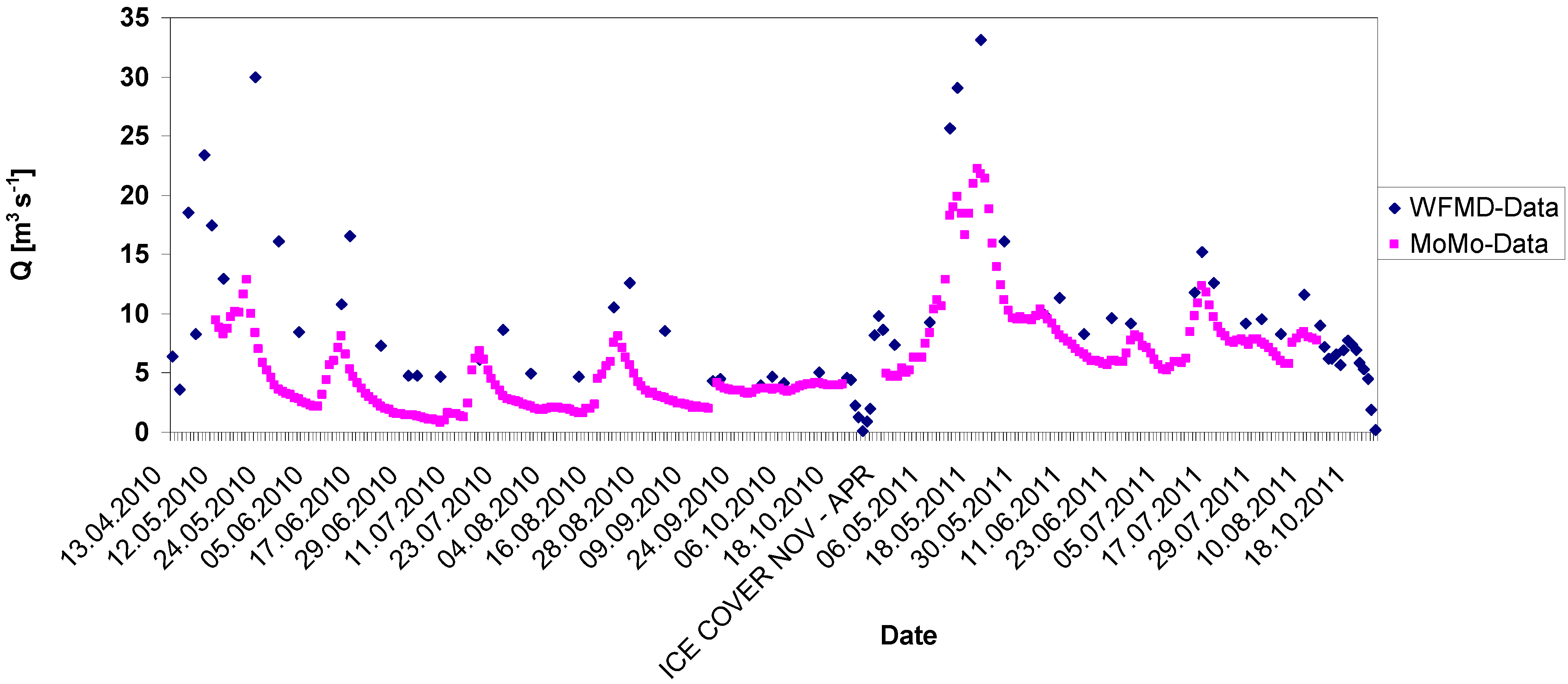
Limited climatological and hydrological data were available, but mostly restricted to the lower KRB. Discharge monitoring stations were located in the upper KRB (Sugnugur River), middle (near Baruunkhara) and lower KRB (downstream of Darkhan). Existing data were insufficient to assess the spatial heterogeneity of temperature and precipitation and to understand hydrological processes in different parts of the river catchment. Climate and discharge monitoring stations were installed in the particularly data scarce upper KRB. Temperature and precipitation maps of the Kharaa River Basin were produced [73]. Runoff contributions from all subcatchments were estimated [19].
There was no regionalized projection for climate and hydrological changes for the Kharaa or other nearby river basins. A scenario study with the large-scale model WaterGAP3 (based on five arc minutes) showed a general increase in mean annual water availability with increasing spring and summer peaks [74]. A moderate increase in precipitation and a continuous, drastic increase in air temperature until the end of the 21st century leads to a slight decrease of simulated discharge [75]. Increasing water consumption around major cities in northern Mongolia is likely to exceed the increases in water availability [76,77].
Up-to-date quantitative information on land cover did not exist. The occurrence of forest fires was described anecdotally but could not be quantified. The links between different landscape units/land covers on the hydrological cycle were poorly understood. Land cover maps were created based on remote sensing and ground truthing. Land cover and land use change were monitored based on multitemporal imagery [30,31,52]. Forest fires and their impacts were quantified [78,79]. Detailed field investigations in the relatively water-rich headwaters of the KRB showed that deforestation through forest fires and (illegal) timber extraction lead to increased runoff with rising flood peaks and intensified erosion, thus having adverse consequences on water availability further downstream [22,34].
Water quality
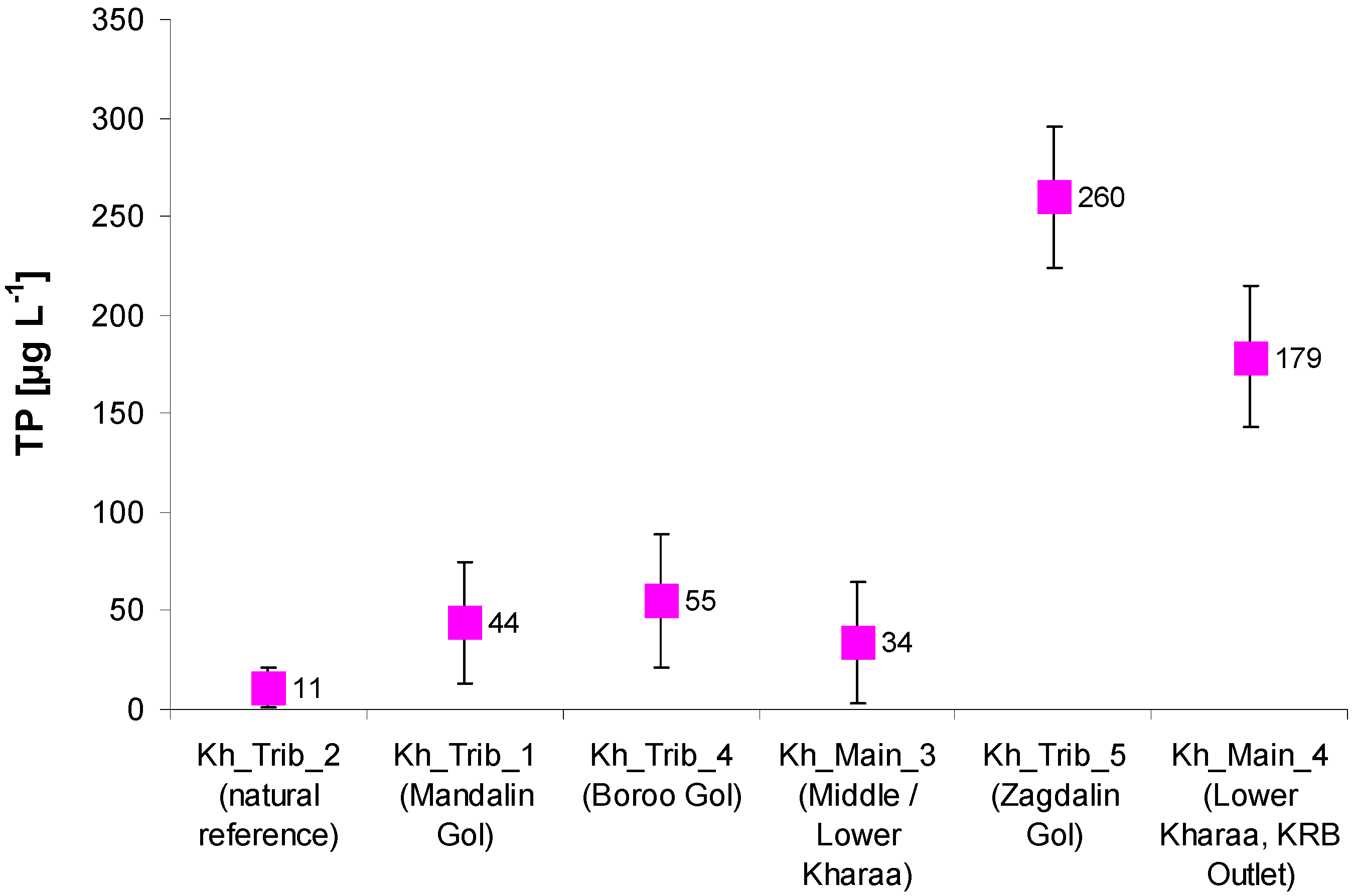
Water quality data was extremely scarce, and documentation on collection methods and data quality were typically lacking. There had not been any documented, systematic survey on surface or groundwater quality at the river basin scale before the project. Moreover, the relevance of individual stressors was unknown. Sampling campaigns along the Kharaa and its tributaries were carried out and three automated water quality monitoring stations were installed in the upstream, midstream and downstream sections of the Kharaa. The observed gradients helped to (a) characterize the manmade increase of pollutant concentrations beyond natural background levels and (b) localize pollutant inflows. Obsolete and/or insufficient urban wastewater management, effluents of gold mining and livestock farming along the river banks were identified as main stressors, and (potential) pollution hot spots were mapped [16,27,37,40,41,44].
Nutrient and sediment emissions, the relative importance of different sources and transport loads were not quantified.Nutrient emissions were estimated using the nutrient emissions model MONERIS [41,44]. Urban systems were found to be the leading source. Sediment sources were identified using geochemical and isotope-based fingerprinting techniques. River-bank erosion was identified as the predominant fine sediment source [47,48]. For the period 2007 to 2013, the transport loads of sediments, nutrients, heavy metals, and sediments were calculated based on water quality and hydrological data [37,44,45,46].
Aquatic ecosystems
There was no consistent typology or classification of water body types. Reference conditions and their alterations under anthropogenic pressures were not described. Therefore, a reference based ecological characterization of surface water bodies was not possible.It was possible to identify four surface water bodies along the main channel of the Kharaa and seven along its tributaries. These eleven water bodies could be assigned to five river types, comparable to the European river typology. Type-specific reference conditions could be identified [46].
Scientific information on the state of aquatic ecosystems did not exist. There were only assumptions about stressors. Therefore, water management decisions taking into account the specific situation of individual water bodies and the surrounding (sub-) catchments were impossible.A comprehensive inventory of the aquatic fauna, physico-chemical and hydromorphological parameters was used to develop reference based ecological assessment tools incorporating several biological indicators and metrices [46]. An initial assessment revealed river sections being at risk of failing the good ecological status.
Urban water management
Information for planning sustainable urban water management was highly fragmented or did not exist. A water budget for the city of Darkhan was calculated, following a compilation of water abstraction and water use data [79,80]. Information on the state of water supply and wastewater management was documented [37,57,79,81].
Despite recent research activities along the Kharaa, Tuul, Orkhon, and Selenga rivers that go beyond the IWRM MoMo project [38,39,82,83], reliable environmental data for most other river basins is scarce to a degree making it a considerable obstacle for river basin management planning. Hydro-meteorological data and information on groundwater availability and quality are often lacking because of a limited monitoring network. Moreover, several environmental monitoring stations and programs have at least temporally ceased to operate since the 1990s, and relatively little is known about the current ecological state of many surface water bodies. With regard to environmental information, the Kharaa River Basin is an exception, however. For this reason, it is now by many, including relevant ministries and the National Water Committee, considered as a model region with reference data sets and methodologies for IWRM development in northern Mongolia.
The following two sections focus on three examples from the context of the IWRM MoMo project: urban water management, the modelling of nutrient emissions, and the assessment of aquatic ecosystems. They illustrate strategies to systematically improve data availability, but also show how initial assessments can be made despite data scarcity.

3.2. Urban Water Management under Data Scarcity

There are significant deficits in water supply and wastewater disposal in Mongolia. Groundwater contamination, water losses in the supply system, limited access to drinking water mainly in informal ger-areas, as well as defective or not adequately equipped WWTPs have negative impacts on human health and the environment [35,37,56,58,79]. Consequently, one key objective of the IWRM MoMo project was an integrated concept for urban water management which included more efficient water distribution and improvements in wastewater treatment and reuse as technical priority measures. The district of Orkhon Sum and the city of Darkhan were chosen as model areas representing rural, peri-urban and urban settings for a deficit analysis and the development and pilot testing of wastewater treatment systems [81].
A lack of reliable data was initially a major challenge for identifying priority measures. Data scarcity included the following aspects:
  • Both the total amount of water abstractions and the limits of ecologically sustainable ground water abstractions were unknown [35,37].
  • Reliable water usage data was difficult to obtain due to a lack of water meters in private households [35,57].
  • Little was known about the quality of drinking water, especially for decentralized supply by small wells on private plots. The (potential) human health impacts of inadequate water supply and poor sanitation were difficult to assess [35,56].
  • A poor state or lack of wastewater treatment systems was widely acknowledged, but the impacts of wastewater discharge on ground and surface water resources and aquatic ecosystems could not be assessed due to a lack of environmental monitoring data [35,79].
The IWRM MoMo project dealt with this data scarcity in two ways: firstly, the project carried out an intensive monitoring program in order to assess current water availability, urban water use, and water quality. This data substantially improved the scientific basis for water management including the identification of priority measures [16]. In the context of urban water management, a concept for deficit analysis, measure identification and priorization (the “toolbox model”) was developed that took into account the limited availability of reliable data. The “toolbox model” defined development objectives at the municipal and river basin scale, taking into account environmental, political, and socio-economic criteria, but also rules for decision making in case of data scarcity. It was designed to propagate measure bundles that help to maximize the environmental and socio-economic benefits within the shortest implementation time at the lowest cost while being as compatible as possible with existing political decisions [54,84].
Based on an ongoing assessment of the situation, several priority measures were identified for the Kharaa River Basin. For urban areas, massive leakage losses (about 50%) in the drinking water distribution system were found to be the largest problem on the supply side. Consequently, a methodology for leak detection that took into account the specific local situation (pipes located at a depth of 4.5–5 m) was developed and major leaks located [57]. For peri-urban and rural areas, the poor quality of (shallow) groundwater was found to be a major problem, requiring a systematic survey and in some cases the provision of alternative water sources [37].
On the sanitation and wastewater side, the need for different, locally adapted solutions was recognized. In urban ger areas, where simple latrines contaminated local groundwater resources and put at risk the health and well-being of the local population, a urine diversion dry toilet (iPiT®) system was installed and tested. This toilet system was an integral component of a nutrient and energy recycling concept, using collected urine as the basis for fertilizer production and feces as a substrate for biogas production [81,85,86]. For small settlements and more sparsely settled urban areas that are far from existing wastewater infrastructures, decentralized options of wastewater collection and treatment were found to be preferential. Two systems were pilot-tested: a constructed wetland that incorporated both wastewater treatment and wood production [81,87] and a small wastewater treatment plant based on the utilization of a special biofilm carrier (WSB® Clean, Bergmann, Germany) that is suitable for settings with potential power cuts and irregular wastewater loadings [81]. Finally, as a technical option for upgrading the central wastewater treatment plant of Darkhan, the sequence batch reactor (SBR) technology was investigated as a flexible and compact option, allowing for capsulated (insulated against frost) and thus energy-effective treatment [59].

3.3. Nutrient Emission Modelling under Data Scarcity

The calculation of nutrient emissions into surface waters, in-stream retention, and resulting loads for nitrogen (N) and phosphorus (P) was performed by applying and adapting the nutrient emission model MONERIS (Modeling Nutrient Emissions in River Systems), version 3.02 [88] at the subbasin level of the KRB at a yearly and a monthly basis [44].
The availability, quality, and spatial resolution of input data and the subsequent data pre-processing determine the precision and reliability of model results to a decisive extent. The KRB is located in three different provinces (Selenge, Tov and Darkhan Uul aimag), for which data availability and restrictions differed. Because of different sources, the quality of model input data was not always consistent. In cases of poor data availability, it was necessary to develop approaches for deriving required input data by refining coarse data sets such as land use classifications based on satellite imagery. The following input data had to be derived or estimated for the application of MONERIS:
  • Atmospheric deposition on the water surface was estimated by evaluating publications, contacting experts, and applying this knowledge to the river basin characteristics.
  • Nitrogen surplus/deficits were calculated by adapting the Organization for Economic Development (OECD) approach [89] and using input data from the Ministry of Food, Agriculture and Light Industry (MOFA) and the Agricultural University of Darkhan.
  • Soil losses were estimated using an empirical approach based on the universal soil loss equation [90,91] and on MONERIS specific correction factors for precipitation ratio (PRCF) and the long term mean Sediment Delivery Ratio (SDR) as described by [88].
  • All waste water treatment plants were localized and missing discharge and pollution information was estimated based on type and size of treatment plants.
  • The number of inhabitants per analytical unit (AU, smallest hydrological sub-catchment in MONERIS, [88]) was derived from different statistical and GIS datasets.
  • Emissions and retention of anthropogenic excreta for areas without wastewater treatment were estimated with an empirical approach.
For the assessment of land cover and use, freely available remote sensing data, including Terra/Aqua MODIS and Landsat scenes as well as Google Earth® imagery were used widely. Validation was performed for all land use classes by ground truthing in all parts of the river basin. This included the application of unmanned aerial vehicles (UAV) to obtain high-resolution imagery for specific investigations in the floodplain (see Figure 3). A project-driven monitoring of water quality was carried out between 2006 and 2013. For this period, it was therefore possible to use quality-assured data, which were particularly valuable for the calculation of transport loads, and for plausibility checks of information sources that did not contain metadata and/or quality control data. The estimations of soil loss for the first MONERIS runs could be cross-checked and refined by intersection with a soil loss map for the KRB based on several erosion studies of the MoMo project [47,48,52]. Surface erosion was found to contribute approximately 22% to the suspended sediment load of the KRB, whereas riverbank erosion contributed up to 75%, mainly caused by livestock trampling. The soil type and soil loss maps were also intersected with land use maps (arable land, grassland, urban areas) and the slopes derived from digital elevation model based on Shuttle Radar Topography Mission (SRTM) data (spatial resolution: 90 m). Slope classes were defined for 0%–1%, 1%–2%, 2%–4%, 4%–8% and >8%). For the application of MONERIS in the KRB, adaptations of MONERIS constants were necessary. Altogether 15 out of 246 model constants had to be adapted [44]. Most adaptations were necessary in the “urban systems” pathway (especially for inhabitants not connected to WWTPs) to include also the rural settlements. Thus an intense data collection was necessary to fulfill the minimum requirements of MONERIS.
The validation of the MONERIS results in data-scarce regions is restricted to a comparison of modeled and observed loads. Since observed loads are calculated on the base of measured runoff and nutrient concentration at gauging stations, the installation of a project-driven surveillance monitoring was of great importance. The discharge is an important descriptor for hydrological forcings and the calculations of loads. Moreover, the long-term comparison of increasing or decreasing discharge trends is a relevant descriptor for decision-makers at the river basin scale. Quality assurance of data is necessary to provide a sound and reliable data base. In our study we installed water quality monitoring stations as data logger for discharge and other parameters (water temperature, pH, electrical conductivity, chlorophyll, turbidity) along the upper, middle, and lower reaches. Discharge observations of the Mongolian surveillance monitoring are available for two sites: one at Baruunkharaa and another one close to the outlet of KRB (Figure 1). The gauging station in Baruunkharaa has been in operation since 1951, thus providing the longest time series in KRB. Contrastingly, the station in Buren Tolgoi downstream of Darkhan started in 1995 and belongs to the Weather and Forecast Monitoring Department of Darkhan (WFMD). This offered the opportunity to compare both time series by installing loggers close to the Mongolian monitoring sites. The comparison of the observed discharge shows similar trends of both data series. However, there was a systematic overestimation of the Mongolian measurements particularly during flood events (Figure 2).
Figure 2. Comparison of discharge Q (observation period 13.04.2010 to 18.10.2011; no data during the period of ice cover between November and April) between Mongolian (Weather and Forecast Monitoring Department of Darkhan—WFMD) and MoMo data logger measurements at the outlet of Kharaa River Basin (KRB) (station Buren Tolgoi, 49°35′29″ N, 105°51′33″ E, 664 m a.s.l.).
Water 07 03486 g002
This phenomenon can be explained by the fact that the observation of the Mongolian monitoring authority is carried out irregularly with a time step of 4–10 days between single measurements. By contrast, the MoMo data logger recorded measurements at 15 min intervals. In addition, during a visit of the official discharge gauging station operated by the WFMD, it was obvious that the applied instruments to determine discharge have not been calibrated over a longer time span (probably many years), and the functionality of the discharge meter was questionable [19]. Peak events during flooding are often missed in the WFMD data series due to the scarce and laborious manual observations. By contrast, the high temporal resolution of the data logger allows for a detailed investigation of hydrological processes and their effects on water quality.
Morphological changes of the river bed at the measuring site were found to be a likely source of miscalculations. At the monitoring site Baruunkharaa, where the meandering Kharaa deposits silty and sandy sediments in form of a shifting river island, the river profile has changed significantly at the site of the gauging station (Figure 3). In fact, the image obtained from cameras mounted on a UAV (octocopter) helps to illustrate recent processes in the floodplain to decision-makers, including the recommendation to shift the location of the gauging station.
For the validation of MONERIS results, the mean calculated loads of the single years were compared to the observed loads. An example of the longtime measurements (2007–2012) of phosphorous concentrations (total phosphorus, TP) along the longitudinal profile from Kharaa main river and its tributaries is given in Figure 4.
Figure 3. Vertical view from an unmanned aerial vehicle (octocopter) on the monitoring location at Baruunkharaa in the middle reaches of the Kharaa River. The cross profile (pink dotted line) of the official gauge (red arrow) is altered due to the formation of a small river island. The MoMo monitoring logger site (green arrow) is only 20 m upstream on a place with strong river bank erosion (flow direction is marked with a white arrow). Location: 48°54′42″ N, 106°4′30″ E, 796 m a.s.l., flight elevation 120 m above ground; the full panorama view is visible here [92].
Water 07 03486 g003
Figure 4. Concentrations of total phosphorus (TP; n = 124) in (µg·L−1) given as mean values and standard deviations in surface water bodies of KRB for the monitoring period 2007 to 2011. The diagram is arranged from the water towers with natural reference conditions in Khentii Mountains downstream to the KRB outlet. The highest concentrations were measured in Zagdalin Gol. Water body codes after [46].
Water 07 03486 g004
Compared to the natural reference conditions in the Khentii Mountains (water body Kh_Trib_2 in Figure 4) the phosphorus enrichment is clearly visible, particularly after the confluence of the Zagdalin Gol (water body Kh_Trib_5) with the main channel of the Kharaa River (water body Kh_Main_4). Based on the long-term series of discharge and water quality measurements, the resulting loads could be calculated for the river basin outlet, showing evidence for a continuous increase of phosphorus concentrations [46].
An overview on the total nutrient emissions (point and diffuse sources) into the KRB shows that agriculture with fertilizer and manure application contributed only 36% and 15% of the total P and N emissions, respectively. Urban settlements were the main sources, contributing 55% (N) and 52% (P) of the total emissions. Since only 35% of the total population in the river basin, are connected to WWTPs, unconnected people in urban areas represent an important proportion of the total emissions (38% of P and 25% of N emissions).
For decision-makers the reliability of nutrient modelling (e.g., by MONERIS) is crucial. A comparison of modelled and observed loads from MONERIS applications in KRB delivered mean deviations between 13% and 15% [41,44] with no systematic error. In the future, the quality assurance of all input data, especially for water quality monitoring, could help to use the full potential of the MONERIS model for the identification of nutrient emission hot spots and the cost-effective implementation of countermeasures.

3.4. Assessing Aquatic Ecology and Environmental Impacts under Data Scarcity

There are significant knowledge deficits regarding aquatic ecosystem health in Mongolia. The country’s pristine freshwater ecosystems are unique in their nature and extremely susceptible to anthropogenic pressures [17]. Therefore, the IWRM MoMo project did not only assess the ecological status of surface waters, but also determined major drivers and impacts of human activities. Moreover, we developed a reference-based ecological assessment scheme and proposed measures to counteract further degradation and enhance the integrity of aquatic ecosystems.
The IWRM MoMo project followed the ideas of European water management approaches as described in the European Water Framework Directive [93]. For the KRB, a lack of information was initially the biggest challenge for establishing a river basin management plan. This particularly involved the following aspects:
  • Surface waters were only poorly described with regard to major physical and chemical factors that determine their characteristics and hence the aquatic ecosystems. Different types of rivers or bodies of water (as a distinct manageable unit) were not defined.
  • Type-specific hydro-morphological, physico-chemical, and biological reference conditions representing a pristine or slightly disturbed ecological status had not been determined.
  • Therefore, an assessment scheme allowing the identification of good ecological status and deviations thereof was not available for Mongolia. Some ecological information was initially available, like species lists of fish [94,95] or benthic invertebrates [96], but ecological knowledge on individual species (ecological preferences, life cycles etc.) or community compositions was and remains extremely limited.
  • The types and magnitudes of significant anthropogenic pressures were not exactly known, but it was obvious that open placer mining and emissions from a few urban centers played a major role. An assessment of the susceptibility of the surface water status to the pressures identified had not been done before.
An integrated monitoring program conducted between 2006 and 2013 included hydro-morphological, physico-chemical and biological (fish, benthic invertebrates and diatoms) surveys [44,46]. An operative monitoring was proposed to Mongolian authorities to assess the status of those water bodies at risk of failing to meet the environmental objectives. The good surface water status (ecological status plus chemical status) was defined by the MoMo project as the environmental objective to be achieved. However, this needs refinement in future river basin management plans, especially with regard to the timespan to achieve these objectives.
The biological quality indicators surveyed, i.e., benthic invertebrate fauna and fish fauna, indicated a good ecological status for most river stretches in the Kharaa River basin (see [46] for details and maps) but also identified the most important pressures and impacts:
  • Open placer gold mining activities in the basin pose a significant pressure on aquatic ecosystems, especially in the Boroo valley and the Gatsuurt area. Effects of open placer mining include dramatic damages in hydromorphology, rising nutrient inputs, high fine sediment loads, and mining-related releases of toxic substances [18,42,51]. The initial risk assessment of the Boroo Gol indicated the “moderate” ecological status. The number of sensitive species as well as biodiversity in the benthic invertebrate community were strongly reduced. Furthermore, an increased share of potamphilic and lotic species was identified, indicating an altered hydrological situation. Additionally, many filamentous green and blue-green algae could be observed during the samplings. This also points towards hydrological alterations and increased nutrient concentrations.
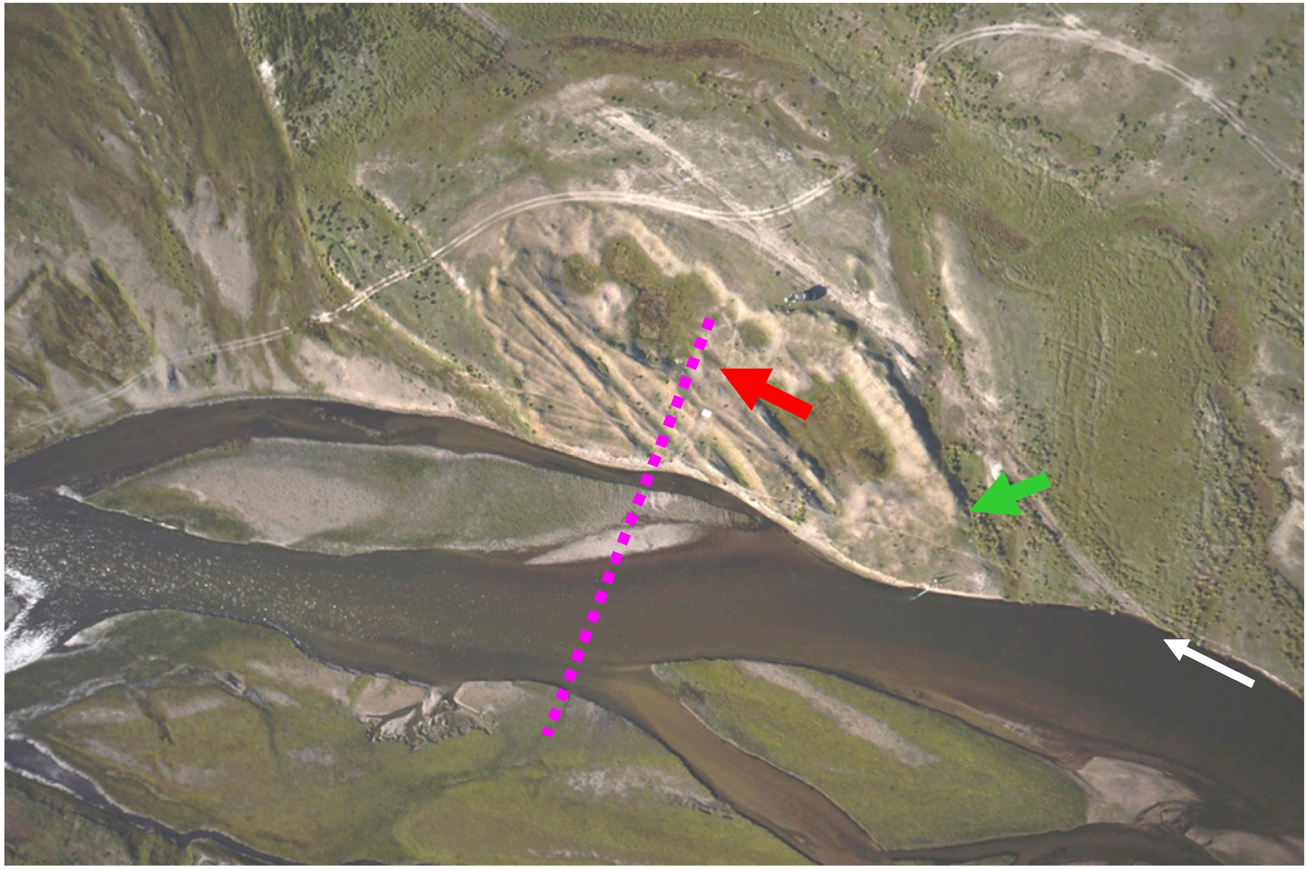
  • Unsustainable land use practices (high intensity of livestock farming, forest fires) and missing riparian vegetation adjacent to the river caused land erosion and influx of eroded sediments into the rivers [33,52]. Structural and functional metrics of the benthic invertebrate community indicated negative effects of fine sediment input from the catchment especially in the middle reaches of Kharaa Main River, but also in some of the tributaries. A reduced number of species, a lower Shannon diversity index [97], a reduced number of sensitive Ephemeroptera (mayflies), Plecoptera (stoneflies), and Trichoptera (caddisflies) (EPT) species as well as an increased number of fine sediment colonizers were found in those stretches where elevated turbidity in the surface water was detected. Sediment matrix traps were installed in selected stream sites in order to quantify fine sediment input from the stream to the river bed and the hyporheic zone. A significantly increased accumulation of sediments in the matrix traps was found downstream of the confluence of Zagdalin River and Kharaa River. Moreover, evidence for the physical clogging of the river bed in some stretches of Kharaa River downstream from the confluence of Zagdalin River was found, reducing the habitat quality for benthic invertebrates with life stages associated with the hyporheic zone and for gravel-spawning fish [47,49].
  • Unsustainable fisheries management caused deficits in the fish populations of the Kharaa River. Besides the pressures from open placer gold mining described above, intensive recreational fishing was found to pose a significant pressure on fish populations. Recreational fishing by local dwellers and excursionists from the capital Ulaanbaatar is common in this area. During the investigations in the Kharaa river basin in total 14 fish species belonging to nine families were recorded [43]. Intensive fishing caused a significant deficit in the distribution of age classes at several river reaches with a relative reduction of larger and older fish. These sexually mature individuals are essential for self-sustaining fish populations. A dramatic decline in occurrence was found for the taimen (Hucho taimen), which is a red-listed fish species in Mongolia. Existing Mongolian laws which define a minimum size for fish caught as well as off-periods for fisheries are not respected by local fishermen and not implemented effectively by the environmental administration but their enforcement will play a crucial role to preserve ecological health of the rivers in the future.
Such an impact assessment is a prerequisite for decision-makers to take aquatic ecosystem health into account during the formulation of river basin management plans. Nevertheless, reference conditions for the lower stream reaches with sandy sediments are yet to be established.

4. Summary of Key Findings

Sufficient, reliable and consistent data is a prerequisite for IWRM planning. Even though the data situation in Mongolia is poor, the Mongolian government has selected IWRM as the conceptual framework for water management planning. Results of a major research project have helped significantly to improve the data base for planning in one model region, the KRB.
Urban water management: A ‘toolbox model’ was developed to analyze deficits, and identify and prioritize interventions. Selected measures were then carried out at pilot scale, including the detection of leakage losses in the drinking water supply network of Darkhan city and several sanitation and wastewater disposal solutions that were adapted to local conditions. They included dry-separation toilet systems for peri-urban areas, constructed wetlands as semi-central systems, and more centralized and technology-intensive treatment options for central urban areas.
Nutrient emission modelling: Poor data availability and inconsistent data were the initial obstacles for nutrient emission modelling at the catchment scale. Therefore, the MONERIS model, which was used in the context of the project, had to be adapted. Some data, e.g., atmospheric deposition of nutrients on water surfaces, had to be estimated by evaluating publications, contacting experts, and applying this knowledge to the river basin characteristics. For the validation of the MONERIS results, mean calculated loads of single years were compared to the observed loads.
Aquatic ecology and environmental impacts: Prior to the project, the surface waters of the KRB had been only poorly described. Neither reference conditions nor surface water types had been defined. The effects of anthropogenic pressures on aquatic ecosystems were largely unknown. An integrated monitoring program from 2006 to 2013, which included hydro-morphological, physico-chemical and biological surveys, helped to come to a first science-based assessment of the state of surface water bodies in the river basin. Such a detailed assessment was found to be the prerequisite for the formulation and implementation of a program of measures to enhance a good ecological status in the Kharaa River.

5. Conclusions and Recommendations

Quality assured data is a key prerequisite for identifying priorities and planning measures in the context of an IWRM implementation. However, in reality, IWRM is often being promoted as an approach in regions where water-related problems are severe and complex but where data availability is poor. Mongolia, a transition country that is currently experiencing dynamic political and socio-economic changes, is a case in point. While the Mongolian government identified IWRM as the general concept for water management in 29 designated river basins of national importance, data availability for planning measures at the river basin scale or in urban areas is typically poor.
Despite the described effort of the IWRM MoMo project, the gathered data is only a starting point for the development of an RBMP as required by Mongolian legislation. There are still minor data gaps in the assessment of the ecological status and the reference conditions for some water bodies. For a few tributaries of the Kharaa the data situation even remains insufficient for drawing science-based management conclusions. Socio-economic data is either non-existing or difficult to obtain. However, a comprehensive analysis of social issues is important for the country-specific context of Mongolia’s IWRM concept to identify human-oriented management strategies that improve livelihood and raise awareness for the advantages of a sustainable water use among the entire population. Also the importance of pollution and water stress of anthropogenic pressures for example tourism, industries, and especially mining is hardly known. Reasons for this are on the one hand the high number of illegal mining sites and on the other hand the lack of legal regulations concerning the registration and inspection of water using and discharging businesses.
According to the present state of knowledge, there are six key recommendations for IWRM implementation in the KRB:
  • A crucial measure to preserve the quantity [19] and the quality [44] of water resources throughout the basin is the protection of the upper stream reaches in the Khentii mountains which can be regarded as “water towers”. The mountainous water courses do not only contribute significantly to the discharge of the Kharaa, but also represent important places of reproduction and a refuge for the aquatic fauna. Therefore, these areas must be protected against exploitation, which explicitly includes mining, deforestation, overgrazing and overfishing.
  • The direct and indirect contamination of surface and ground waters by mining and industrial activities needs to be reduced. In particular, this includes waste water ponds as well as tailings of mines and the ash basins of thermal power plants such as in Darkhan [40].
  • Since wastewater emissions from urban areas represent important point sources of contamination, improvements in centralized urban wastewater systems are essential. Moreover, recent experiences demonstrated that already existing technologies can be successfully adapted to the specific conditions in Mongolia, which include extremely cold winters [81].
  • The short-circuit from infiltration of untreated wastewater close to groundwater extraction sites for domestic self-supply in river riparian plains has to be disrupted. The installation of adapted semi-central wastewater collection and treatment technologies in combination with timber production is one option that would also reduce the pressure on riparian tree vegetation [33,81].
  • The regeneration of river riparian zones has to be fostered by eliminating/reducing the pressure of exploitation (e.g., livestock herding). Protection of the remnants of non-degraded riparian zones as well as areas with a high potential of self-regeneration have high priority [49].
  • The implementation and enforcement of existing fishery laws which define a minimum size for fish caught as well as off-periods for fisheries are of high importance to preserve the ecological health of the rivers in the long run. A survey among fishermen in the Kharaa catchment in 2012 showed that many locals could not identify protected fish species properly. Moreover, most interviewees were not aware of existing regulations and did not know about the ecological background of off-periods. Therefore, information campaigns and capacity development activities seem to be of the highest importance here.
In conclusion, the IWRM MoMo project has significantly improved the scientific basis for decision-making on the water resources in the KRB. However, the project also demonstrated that the data needs for a science-based IWRM concept are considerable. Therefore, IWRM implementation should, beyond a systematic data collection, also include a defined strategy for measure selection and prioritization that takes into account the poor data situation, since the implementation of obviously necessary components of an IWRM should not be delayed until this is ‘definitely proven’ by empirical data. This is particularly true for problems and solutions for which there is historical evidence from other regions. Therefore, it can be argued that good practices in water management, sanitation, and water pollution control may also be introduced independently of a comprehensive IWRM concept.
Even though research projects can play a role for improving data availability in data-scarce regions, their transient character also means that they cannot replace routine monitoring which has to be carried out by dedicated local institutions. Moreover, in case of temporary research projects the storage and documentation of data in a way that it becomes accessible to decision-makers in the water sector and other scientists are important concerns.

Supplementary Material

Supplementary material can be accessed at: https://www.mdpi.com/2073-4441/7/6/3486/s1.

Acknowledgments

The results presented in this paper are based on the research and development project “Integrated Water Resources Management in Central Asia: Model Region Mongolia”, funded by the German Federal Ministry of Education and Research (BMBF) in the framework of the FONA (Research for Sustainable Development) initiative (Grant No. 033L003). We acknowledge the support provided by the Project Administration Jülich (PTJ) and the BMBF/International Bureau in the context of the “Assistance for Implementation” (AIM) scheme. We gratefully thank Martin Oczipka (Faculty of Spatial Information, University of Applied Sciences Dresden, Germany) for the provision of panoramic aerial images of the KRB [92]. Finally, we would like to thank the reviewers for their very detailed and constructive suggestions that have helped to improve the manuscript significantly.

Author Contributions

Daniel Karthe structured and drafted the original manuscript and coordinated the work of the co-authors. Jürgen Hofmann drafted Section 3.3 (nutrient modelling under data scarcity) and contributed to all sections dealing with water quality and the characterization of water body status. Ralf Ibisch drafted Section 3.4 (ecological assessment under data scarcity) and linked ecological assessments with findings on water quantity and quality. Sonja Heldt contributed to Section 2.4 (water governance) and Section 3.1 (characterization of water bodies). Katja Westphal co-authored the sections dealing with urban water management (Section 2.3 and Section 3.2) and helped to format the manuscript. Lucas Menzel thoroughly revised the manuscript and included information on the links between climate, land cover, and hydrology. Saulyegul Avlyush contributed information on water resources monitoring in Mongolia and provided a Mongolian translation of the abstract (Supplementary Material). Marcus Malsy contributed information on water availability and consumption and their trends (Section 3.1). All co-authors helped to revise the final manuscript.

Conflicts of Interest

The authors declare no conflict of interest.

References

  1. Global Water Partnership Technical Advisory Committee (GWP-TAC). In Integrated Water Resources Management; GWP-TAC: Stockholm, Sweden, 2000.
  2. Heldt, S. The EU-WFD as an Implementation Tool for IWRM in non-European Countries. Case Study: Drafting a River Basin Management Plan for the Kharaa River in Northern Mongolia. Master Thesis, Duisburg-Essen University, Duisburg-Essen, Germany, 2014. [Google Scholar]
  3. Snellen, W.B.; Schrevel, A. IWRM: For Sustainable use of Water 50 Years of International Experience with the Concept of Integrated Water; Ministry of Agriculture, Nature and Food Quality: Wageningen, The Netherlands, 2004.
  4. Anderson, A.; Karar, E.; Farolfi, S. Synthesis: IWRM lessons for implementation. Water SA 2008, 34, 665–669. [Google Scholar]
  5. United Nations World Water Assessment Program (UN-WWAP). Water—A Shared Responsibility; The United Nations World Water Development Report 2; United Nations Educational, Scientific and Cultural Organization (UNESCO) and Berghahn Books: Paris, France; New York, NY, USA, 2006. [Google Scholar]
  6. Borchardt, D.; Ibisch, R. Integrated Water Resources Management in a Changing World: Lessons Learnt and Innovative Perspectives; IWA Publishing: London, UK, 2013. [Google Scholar]
  7. United Nations Environmental Programme (UNEP). Status Report on the Application of Integrated Approaches to Water Resources Management; UNEP: Nairobi, Kenya, 2012. [Google Scholar]
  8. Mitchell, B. Comments by Bruce Mitchell on water forum contribution “Integrated water resources management: A re-assessment by Asit K. Biswas”. Water Int. 2004, 29, 398–399. [Google Scholar] [CrossRef]
  9. Jeffrey, P.; Gearey, M. Integrated water resource management: Lost in the road from ambition to realization? Water Sci. Technol. 2006, 53, 1–8. [Google Scholar] [CrossRef] [PubMed]
  10. Hering, J.; Ingold, K.M. Water resources management: What should be integrated? Science 2012, 336, 1234–1235. [Google Scholar] [CrossRef] [PubMed]
  11. Biswas, A.K. Integrated water resource management: Is it working? Int. J. Water Resour. D 2008, 24, 5–22. [Google Scholar] [CrossRef]
  12. Stålnacke, P.; Gooch, G.D. Integrated water resource management. Irrig. Drain 2010, 24, 155–159. [Google Scholar] [CrossRef]
  13. Cook, B.R.; Spray, C.J. Ecosystem services and integrated water resource management: Different paths to the same end? J. Environ. Manag. 2012, 109, 93–100. [Google Scholar] [CrossRef] [PubMed]
  14. Liu, S.; Crossman, N.D.; Nolan, M.; Ghirmay, H. Bringing ecosystem services into integrated water resources management. J. Environ. Manag. 2013, 129, 92–102. [Google Scholar] [CrossRef] [PubMed]
  15. Schoeman, J.; Allan, C.; Finlayson, C.M. A new paradigm for water? A comparative review of integrated, adaptive and ecosystem-based water management in the Anthropocene. Int. J. Water Res. 2014, 30, 377–390. [Google Scholar] [CrossRef]
  16. Karthe, D.; Heldt, S.; Houdret, A.; Borchardt, D. IWRM in a country under rapid transition: Lessons learnt from the Kharaa River Basin, Mongolia. Environ. Earth Sci. 2015. [Google Scholar] [CrossRef]
  17. Mongolian Ministry for Environment and Green Development (MEGD). Integrated Water Resource Management National Assessment Report; Volume I & Volume II, MEGD: Ulanbaatar, Mongolia, 2012.
  18. Karthe, D.; Chalov, S.; Borchardt, D. Water resources and their management in Central Asia in the early 21st century: Status, challenges and future prospects. Environ. Earth Sci. 2015, 73, 487–499. [Google Scholar] [CrossRef]
  19. Menzel, L.; Hofmann, J.; Ibisch, R. Untersuchung von Wasser-und Stoffflüssen als Grundlage für ein Integriertes Wasserressourcen-Management im Kharaa-Einzugsgebiet (Mongolei). Hydrol. Wasserbewirts. 2011, 55, 88–103. (In German) [Google Scholar]
  20. Minderlein, S.; Menzel, L. Evapotranspiration and energy balance dynamics of a semi-arid mountainous steppe and shrubland site in Northern Mongolia. Environ. Earth Sci. 2015, 73, 593–609. [Google Scholar] [CrossRef]
  21. Hülsmann, L.; Geyer, T.; Schweitzer, C.; Priess, J.; Karthe, D. Initial results and limitations of the SWAT model applied to the Kharaa River Catchment in Northern Mongolia. Environ. Earth Sci. 2015, 73, 581–592. [Google Scholar] [CrossRef]
  22. Kopp, B.; Minderlein, S.; Menzel, L. Soil moisture dynamics in a mountainous headwater area in the discontinuous permafrost zone of Northern Mongolia. Arctic Antartct Alpine Res. 2014, 46, 459–470. [Google Scholar] [CrossRef]
  23. Intergovernmental Panel on Climate Change (IPCC). Climate Change 2007: Impacts, Adaptation and Vulnerability. Contribution of Working Group II to the Fourth Assessment Report of the Intergovernmental Panel on Climate Change; Cambridge University Press: Cambridge, UK; New York, NY, USA, 2007. [Google Scholar]
  24. Wang, L.; D’Odorico, P.; Evans, J.P.; Eldridge, D.J.; McCabe, M.F.; Caylor, K.K.; King, E.G. Dryland ecohydrology and climate change: Critical issues and technical advances. Hydrol. Earth Syst. Sci. 2012, 16, 2585–2603. [Google Scholar] [CrossRef] [Green Version]
  25. Batimaa, P. Climate Change Vulnerability and Adaptation in the Livestock Sector of Mongolia; Final Report Project No. AS 06; Assessments of Impacts and Adaptations to Climate Change (AIACC): Washington, DC, USA, 2006. [Google Scholar]
  26. Batimaa, P.; Batnasan, N.; Bolormaa, B. Climate change and water resources in Mongolia. In Uncertainties in Water Resource Management: Causes, Technologies and Consequences; Technical Documents in Hydrology No. 1; Basandorj, B., Oyunbatar, D., Eds.; United Nations Educational, Scientific and Cultural Organization (UNESCO): Jakarta, Indonesia, 2008; pp. 7–12. [Google Scholar]
  27. Karthe, D.; Kasimov, N.; Chalov, S.; Shinkareva, G.; Malsy, M.; Menzel, L.; Theuring, P.; Hartwig, M.; Schweitzer, C.; Hofmann, J.; et al. Integrating multi-scale data for the assessment of water availability and quality in the Kharaa-Orkhon-Selenga River system. Geogr. Environ. Sustain. 2014, 3, 65–86. [Google Scholar]
  28. Menzel, L.; Aus der Beek, T.; Törnros, T. Hydrological impact of climate and landuse change – results from the MoMo project. In Uncertainties in Water Resource Management: Causes, Technologies and Consequences; Technical Documents in Hydrology No. 1; Basandorj, B., Oyunbatar, D., Eds.; United Nations Educational, Scientific and Cultural Organization (UNESCO): Jakarta, Indonesia, 2008; pp. 13–18. [Google Scholar]
  29. Sato, T.; Kimura, F.; Kitoh, A. Projection of global warming onto regional precipitation over Mongolia using a regional climate model. J. Hydrol. 2007, 333, 144–154. [Google Scholar] [CrossRef]
  30. Priess, J.; Schweitzer, C.; Wimmer, F.; Batkhishig, O.; Mimler, M. The consequences of land-use change and water demands in Central Mongolia. Land Use Policy 2011, 28, 4–10. [Google Scholar] [CrossRef]
  31. Schweitzer, C. Modelling Land-Use and Land-Cover Change and Related Environmental Impacts in Northern Mongolia. Ph.D. Thesis, Martin-Luther University, Halle-Wittenberg, Germany, 2012. [Google Scholar]
  32. Zhang, F.; Zhou, G.; Wang, Y.; Yang, F.; Nilsson, C. Evapotranspiration and crop coefficient for a temperate desert steppe ecosystem using eddy covariance in Inner Mongolia, China. Hydrol. Process. 2012, 26, 379–386. [Google Scholar] [CrossRef]
  33. Hofmann, J.; Tuul, D.; Enkhtuya, B. Agriculture in Mongolia under pressure of agronomic nutrient imbalances and food security demands: A case study of stakeholder participation for future nutrient and water resource management. In Integrated Water Resource Management: Concept, Research and Implementation; Borchardt, D., Bogardi, J., Ibisch, R., Eds.; Springer: Berlin/Heidelberg, Germany, 2015; in press. [Google Scholar]
  34. Lange, J.; Kopp, B.; Bents, M.; Menzel, L. Tracing variability of run-off generation in mountainous permafrost of semi-arid north-eastern Mongolia. Hydrol. Process. 2014, 29, 1046–1055. [Google Scholar] [CrossRef]
  35. MoMo Consortium Integrated Water Resources Management for Central Asia: Model Region Mongolia (MoMo). Case Study in the Kharaa River Basin. Final Project Report. Available online: http://www.iwrm-momo.de/download/MoMo%202009_MoMo1%20Final%20Report.pdf (accessed on 6 March 2015).
  36. Batsukh, N.; Dorjsuren, D.; Batsaikhan, G. The Water Resources, Use and Conservation in Mongolia; First National Report; National Water Committee: Ulaanbaatar, Mongolia, 2008.
  37. Hofmann, J.; Watson, V.; Scharaw, B. Groundwater quality under stress: Contaminants in the Kharaa River basin (Mongolia). Environ. Earth Sci. 2015, 73, 629–648. [Google Scholar] [CrossRef]
  38. Thorslund, J.; Jarsjö, J.; Chalov, S.R.; Belozerova, E.V. Gold mining impact on riverine heavy metal transport in a sparsely monitored region: The upper Lake Baikal Basin case. J. Environ. Monitor. 2012, 14, 2780–2792. [Google Scholar] [CrossRef] [PubMed]
  39. Chalov, S.R.; Zavadsky, A.S.; Belozerova, E.V.; Bulacheva, M.P.; Jarsjö, J.; Thorslund, J.; Yamkhin, J. Suspended and dissolved matter fluxes in the upper Selenga River Basin: Synthesis. Geogr. Environ. Sustain. 2012, 2, 78–94. [Google Scholar]
  40. Pfeiffer, M.; Batbayar, G.; Hofmann, J.; Siegfried, K.; Karthe, D.; Hahn-Tomer, S. Investigating arsenic (As) occurrence and sources in ground, surface, waste and drinking water in northern Mongolia. Environ. Earth Sci. 2015, 73, 649–662. [Google Scholar] [CrossRef]
  41. Hofmann, J.; Venohr, M.; Behrendt, H.; Opitz, D. Integrated water resources management in Central Asia: Nutrient and heavy metal emissions and their relevance for the Kharaa River Basin, Mongolia. Water Sci. Technol. 2010, 62, 353–363. [Google Scholar] [CrossRef] [PubMed]
  42. Krätz, D.; Ibisch, R.; Saulyegul, A.; Ganganmurun, E.; Sonikhishig, N.; Borchardt, D. Impacts of open placer gold mining on aquatic communities in Rivers of the Khentii Mountains, North-East Mongolia. Mong. J. Biol. Sci. 2010, 8, 41–50. [Google Scholar]
  43. Avlyush, S. Effects of Surface Gold Mining on Macroinvertebrate Communities: A Case Study in River Systems in the North-East of Mongolia; Lambert Academic Publishing: Saarbrücken, Germany, 2011. [Google Scholar]
  44. Hofmann, J.; Hürdler, J.; Ibisch, R.; Schaeffer, M.; Borchardt, D. Analysis of recent nutrient emission pathways, resulting surface water quality and ecological impacts under extreme continental climate: The Kharaa River Basin (Mongolia). Int. Rev. Hydrobiol. 2011, 96, 484–519. [Google Scholar] [CrossRef]
  45. Hofmann, J.; Rode, M.; Theuring, P. Recent developments in river water quality in a typical Mongolian river basin, the Kharaa case study. In Proceedings of IAHS-IAPSO-IASPEI Understanding Freshwater Quality Problems in a Changing World, Gothenburg, Sweden, 22–26 July 2013; Volume 361, pp. 123–131.
  46. Hofmann, J.; Karthe, D.; Ibisch, R.; Schäffer, M.; Kaus, A.; Avlyush, S.; Heldt, S. Initial Characterization and Water Quality Assessment of Stream Landscapes in Northern Mongolia and its Integration into a River Basin Management Plan. Water 2015, 7, 3166–3205. [Google Scholar]
  47. Hartwig, M.; Theuring, P.; Rode, M.; Borchardt, D. Suspended sediments in the Kharaa River catchment (Mongolia) and its impact on hyporheic zone functions. Environ. Earth Sci. 2012, 65, 1535–1546. [Google Scholar] [CrossRef]
  48. Theuring, P.; Rode, M.; Behrens, S.; Kirchner, G.; Jha, A. Identification of fluvial sediment sources in a meso-scale catchment, Northern Mongolia. Hydrol. Process. 2013, 27, 845–856. [Google Scholar] [CrossRef]
  49. Hartwig, M.; Borchardt, D. Alteration of key hyporheic functions through biological and physical clogging along a nutrient and fine-sediment gradient. Ecohydrology 2014. [Google Scholar] [CrossRef]
  50. Schäffer, M.; Ibisch, R.B.; Borchardt, D. Invertebrate lebensgemeinschaften als indikatoren für landnutzungseffekte im Norden der Mongolei. In Erweiterte Zusammenfassungen der Jahrestagung 2008, Deutsche Gesellschaft für Limnologie; Eigenverlag der DGL: Krefeld, Germany, 2009; pp. 308–312. (In German) [Google Scholar]
  51. Avlyush, S.; Schäffer, M.; Borchardt, D. Life cycles and habitat selection of two sympatric mayflies under extreme continental climate (River Kharaa, Mongolia). Int. Rev. Hydrobiol. 2013, 98, 141–154. [Google Scholar] [CrossRef]
  52. Priess, J.A.; Schweitzer, C.; Batkhishig, O.; Koschitzki, T.; Wurbs, D. Impacts of agricultural land-use dynamics on erosion risks and options for land and water management in Northern Mongolia. Environ. Earth Sci. 2015, 73, 697–708. [Google Scholar] [CrossRef]
  53. Anthonj, C.; Beskow, S.; Dornelles, F.; Fushita, A.T.; Galharte, C.A.; Galvão, P.; Gatti Junior, P.; Gücker, B.; Hildebrandt, A.; Karthe, D.; et al. Water in Urban Regions: Building Future Knowledge to Integrate Land Use, Ecosystem Services and Human Health; German National Academy of Sciences Leopoldina, Brazilian Academy of Sciences, German Young Academy: Rio de Janeiro, Brazil; Berlin, Germany, 2015; p. 32. [Google Scholar]
  54. Rost, G.; Londong, J.; Dietze, S.; Osor, G. Integrated urban water management—Development of an adapted management approach. Case study area: Darkhan, Kharaa catchment, Mongolia. Environ. Earth Sci. 2015, 73, 863–872. [Google Scholar] [CrossRef]
  55. Hofmann, J. Bericht über die Untersuchungen von Grundwasser und Boden auf Schwermetalle und Cyanid in Khongor Sum; Report for the Mongolian Water Authority; Leibnitz Institut für Gewässerökologie und Binnenfischerei: Berlin, Germany, 2008. (In German) [Google Scholar] [CrossRef]
  56. Karthe, D.; Sigel, K.; Scharaw, B.; Stäudel, J.; Hufert, F.; Borchardt, D. Towards an integrated concept for monitoring and improvements in water supply, sanitation and hygiene (WASH) in urban Mongolia. Water Risk 2012, 20, 1–5. [Google Scholar]
  57. Scharaw, B.; Westerhoff, T. A leak detection in drinking water distribution network of Darkhan in framework of the project Integrated Water Resources Management in Central Asia, Model Region Mongolia. In Proceedings of the IWA 1st Central Asian Regional Young and Senior Water Professionals Conference, Almaty, Kazakhstan, 22–23 September 2011; pp. 275–282.
  58. Sigel, K.; Altantuul, K.; Basandorj, D. Household needs and demand for improved water supply and sanitation in peri-urban ger areas: The case of Darkhan, Mongolia. Environ. Earth Sci. 2012, 65, 1561–1566. [Google Scholar] [CrossRef]
  59. Heppeler, J. Optimization of the Operation of a Sequencing Batch Reactor (SBR)—On the Example of the Pilot Wastewater Treatment Plant in Darkhan, Mongolia. Master’s Thesis, University of Stuttgart, Stuttgart, Germany, 2012. [Google Scholar]
  60. Houdret, A.; Dombrowsky, I.; Horlemann, L. The institutionalization of river basin management as politics of scale - insights from Mongolia. J. Hydrol. 2014, 519, 2392–2404. [Google Scholar] [CrossRef]
  61. Horlemann, L.; Dombrowsky, I. Institutionalising IWRM in developing and transition countries: The case of Mongolia. Environ. Earth Sci. 2012, 65, 1547–1559. [Google Scholar] [CrossRef]
  62. Mongolian Ministry for Environment and Green Development (MEGD). Orkhon River Basin Integrated Water Management Plan; MEGD: Ulaanbaatar, Mongolia, 2012.
  63. Mongolian Ministry for Environment and Green Development (MEGD). Tuul River Basin Integrated Water Management Plan; MEGD: Ulaanbaatar, Mongolia, 2012.
  64. Livingstone, A.; Erdenechimeg, C.; Oyunsuvd, A. Needs Assessment on Institutional Capacity for Water Governance in Mongolia; United Nations Development Program (UNDP) and Government of Mongolia: Ulaanbaatar, Mongolia, 2009.
  65. Lkhagvadorj, A. Fiscal Federalism and Decentralization in Mongolia; Universitätsverlag Potsdam: Potsdam, Germany, 2010. [Google Scholar]
  66. Water Law of Mongolia; The Great State Hural of Mongolia: Ulaanbaatar, Mongolia, 2012.
  67. Lkhagvadorj, A. Analysis on Mongolia’s Integrated Budget Law; SDC Publications: Ulaanbaatar, Mongolia, 2012. [Google Scholar]
  68. Davaa, G.; Oyunbaatar, D.; Sugita, M. Surface water of Mongolia. 2006. Available online: http://raise.suiri.tsukuba.ac.jp/new/press/youshi_sugita8.pdf (accessed on 16 February 2015).
  69. Zandaryaa, S. Water Quality of the Kharaa River Basin, Mongolia: Pollution Threats and Hotspots Assessment; Technical Report UNESCO/UNOPS: Ulaanbaatar, Mongolia, 2013; p. 88. Available online: http://iwlearn.net/iw-projects/4029/reports/water-quality-of-the-kharaa-river-basin-mongolia-pollution-threats-and-hotspots-assessment (accessed on 16 February 2015).
  70. Yadamsuren, O. Use of macroinvertebrates in Bioassessment of Land Use and Water Quality in Northern Mongolia. Ph.D. Thesis, Clemson University, Clemson, SC, USA, 2014. [Google Scholar]
  71. Janchivdorj, L. The Tuul River: Ecological Changes and Water Management Issue, Report; MAS Institute of Geoecology: Ulaanbaatar, Mongolia, 2011; p. 224. (In Mongolian) [Google Scholar]
  72. Törnros, T.; Menzel, L. Heading for knowledge in a data scarce river basin: Kharaa, Mongolia. In Status and Perspectives of Hydrology in Small Basins; Herrmann, A., Schumann, S., Eds.; IAHS Publication: Wallingford, NH, USA, 2010; pp. 270–275. [Google Scholar]
  73. Wimmer, F.; Schlaffer, S.; aus der Beek, T.; Menzel, L. Distributed modelling of climate change impacts on snow sublimation in northern Mongolia. Adv. Geosci. 2009, 21, 117–124. [Google Scholar] [CrossRef]
  74. Malsy, M.; Aus der Beek, T.; Eisner, S.; Flörke, M. Climate change impacts on Central Asian water resources. Adv. Geosci. 2012, 32, 77–83. [Google Scholar] [CrossRef]
  75. Menzel, L.; Törnros, T. Climate Change and Water Resources in Northern Mongolia. Available online: http://presentations.copernicus.org/EGU2014-15992_presentation.pdf (accessed on 28 March 2015).
  76. Malsy, M.; Heinen, M.; aus der Beek, T.; Flörke, M. Water resources and socio-economic development in a water scarce region on the example of Mongolia. Geo-Öko 2013, 34, 27–49. [Google Scholar]
  77. Malsy, M.; Aus der Beek, T.; Flörke, M. Evaluation of large scale precipitation data sets for water resources modelling in Central Asia. Environ. Earth Sci. 2015, 73, 787–799. [Google Scholar] [CrossRef]
  78. Schweitzer, C.; Priess, J.A. Linking wildfire behaviour and land-use modelling in Northern Mongolia. In Proceedings of the International Environmental Modelling and Software Society (iEMSs), International Congress on Environmental Modelling and Software Modelling for Environment’s Sake, Ottawa, ON, Canada, 5–8 July 2010.
  79. Scharaw, B.; Dietze, S. Model supported design and operation of a wastewater treatment pilot plant. In Proceedings of the 55th International Scientific Colloquium, Ilmenau, Germany, 13–17 September 2010; Volume 13–17, pp. 57–61.
  80. Hofmann, J.; Husemann, P. Darkhan Water Cycle 2010. Available online: https://www.researchgate.net/publication/269393278?channel=doi&linkId=54886bb40cf268d28f08f2e8&showFulltext=true (accessed on 22 June 2015).
  81. Karthe, D.; Heldt, S.; Rost, G.; Londong, J.; Ilian, J.; Heppeler, J.; Khurelbaatar, G.; Sullivan, C.; van Afferden, M.; Stäudel, J.; et al. Modular concept for municipal water management in the Kharaa River Basin, Mongolia. In Integrated Water Resources Management: Concept, Research and Implementation; Borchardt, D., Bogardi, J., Ibisch, R., Eds.; Springer: Heidelberg, Germany, 2015; in press. [Google Scholar]
  82. Brumbaugh, W.G.; Tillitt, D.E.; May, T.W.; Javzan, C.; Komov, V.T. Environmental survey in the Tuul and Orkhon River basins of north-central Mongolia, 2010: Metals and other elements in streambed sediment and floodplain soil. Environ. Monit. Assess. 2013. [Google Scholar] [CrossRef] [PubMed]
  83. Chalov, S.; Jarsjö, J.; Kasimov, N.S.; Romanchenko, A.O.; Pietrón, J.; Thorslund, J.; Promakhova, E.V. Spatio-temporal variation of sediment transport in the Selenga River Basin, Mongolia and Russia. Environ. Earth Sci. 2015, 73, 663–680. [Google Scholar] [CrossRef]
  84. Rost, G.; Londong, J. Development of a toolbox model for integrated urban water management case study area Darkhan, Kharaa catchment, Mongolia. In Proceedings of the International Solid Waste, Water and Wastewater Congress, 3WIstanbul’2013, Instanbul, Turkey, 22–24 May 2013; pp. 1463–1471.
  85. Bruski, C. Gemeinsame Faulung von Klärschlamm und Fäzes unter Extremen Klimatischen Bedingungen-Beispiel Mongolei. Schriftenreihe des Bauhaus-Institut für Zukunftsweisende Infrastruktursysteme (b.is); Rhombos-Verlag: Weimar and Berlin, Germany, 2015; Volume 16. (In German) [Google Scholar]
  86. Schuster, C. Technische Entwicklung und Ökonomischer Vergleich Angepasster, Leitungsungebundener Sanitärsysteme mit Integrierter Abfallentsorgung für Jurten-Siedlungen in der Stadt Darkhan, Mongolei; Bauhaus-Universität Weimar: Weimar, Germany, 2012. (In German) [Google Scholar]
  87. Westphal, K. Scenario Development of a Large-scale Willow Based Wastewater Treatment for the Village of Khongor in Mongolia with Special Focus on Design and Dimensioning. Master Thesis, Brandenburg University of Technology Cottbus, Cottbus, Germany, 2013. [Google Scholar]
  88. Venohr, M.; Hiert, U.; Hofmann, J.; Opitz, D.; Gericke, A.; Wetzig, A.; Natho, S.; Neumann, F.; Hürdler, J.; Matranga, M.; et al. Modelling of nutrient emissions in river systems–MONERIS Methods and background. Int. Rev. Hydrobiol. 2011, 96, 435–483. [Google Scholar] [CrossRef]
  89. Organisation for Economic Co-operation and Development (OECD). National Soil Surface Nitrogen Balances–Explanatory Notes; OECD: Paris, France, 2001; p. 20. Available online: http://www.oecd.org/tad/sustainable-agriculture/1916652.pdf (accessed on 26 June 2015).
  90. Deutsche Industrienorm (DIN) 19708. Bodenbeschaffenheit Ermittlung der Erosionsgefährdung von Böden durch Wasser mit Hilfe der ABAG; Normenausschuss Wasserwesen im DIN: Berlin, Germany, 2005. (In German) [Google Scholar]
  91. Wischmeier, W.; Smith, D. Predicting Rainfall Erosion Loss: A Guide to Conservation Planning; Agriculture Handbook 537; United States Department of Agriculture: Beltsville, MD, USA, 1978; p. 58. [Google Scholar]
  92. Oczipka, M. Monitoring from Air. Detail from a Spherical Panorama of the Kharaa River Floodplain at Baruunkharaa. 2015. Available online: https://www.htw-dresden.de/fileadmin/userfiles/geo/Labore/Labor_Photogrammetrie_Fernerkundung/Panorama/KharaaBaroun/Pano_1_KharaaBaroun_Hoehe1.htm (accessed on 26 June 2015).
  93. European Community (EC) Directive 2000/60/EC of the European Parliament and of the Council of 23 October 2000 Establishing a Framework for Community Action in the Field of Water Policy. Off. J. Eur. Commun. 2000, L327, pp. 1–72. Available online: http://eur-lex.europa.eu/resource.html?uri=cellar:5c835afb-2ec6-4577-bdf8-756d3d694eeb.0004.02/DOC_1&format=PDF (accessed on 22 June 2015).
  94. Kottelat, M. Fishes of Mongolia. In A Check-List of the Fishes Known to Occur in Mongolia with Comments on Systematics and Nomenclature; The World Bank: Washington, DC, USA, 2006. [Google Scholar]
  95. Ocock, J.; Baasanjav, G.; Bailie, J.E.M.; Erdenebat, M.; Kottelat, M.; Mendsaikhan, B.; Smith, K. Mongolian Red List of Fishes, Regional Red List Series Volume 3; Zoological Society: London, UK, 2006. [Google Scholar]
  96. Teslenko, V.A.; Bazova, N.V. On the stonefly (Plecoptera) fauna of the transfrontier Selenga River basin. Entomol. Rev. 2009, 8, 1059–1068. [Google Scholar] [CrossRef]
  97. Washington, H.G. Diversity, biotic and similarity indices: A review with special relevance to aquatic ecosystems. Water Res. 1984, 18, 653–694. [Google Scholar] [CrossRef]

