
A Review on Soil Moisture Dynamics Monitoring in Semi-Arid Ecosystems: Methods, Techniques, and Tools Applied at Different Scales


Abstract
:1. Introduction
2. Materials and Methods
3. Analysis and Discussion
3.1. Semi-Arid Lands
3.1.1. Ecological Restoration in the Western US

3.1.2. Monitoring and Evaluation of Ecological Restoration
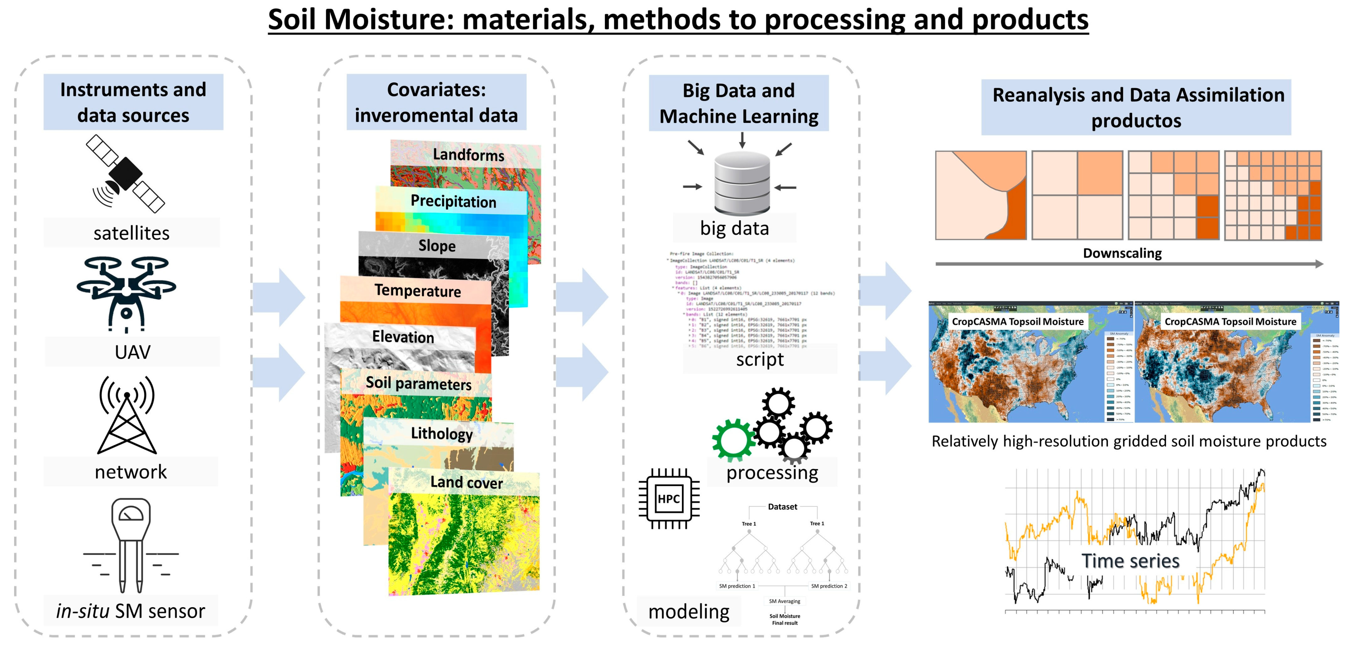
3.2. Measurement and Monitoring of Soil Moisture Dynamics
3.2.1. Remote Sensing: Satellite Dataset for Monitoring Soil Moisture Dynamics
Models and Approaches for Monitoring Soil Moisture Dynamics Using Satellite Dataset
- (i).
- Empirical models: leveraging correlations between remote sensing data—such as surface temperature, radar, vegetation index, and ground-measured data, offer simplicity and ease of data access but suffer from limited interpretability and reliance on specific calibration datasets. In our review, we found that the Water Cloud Model (WCM) and the Dubois Model are commonly used to estimate SM using synthetic aperture radar (SAR) backscatter. [51]. Dubois et al., (1995) [52] evaluated several SAR data sets by comparing derived SM values with in situ measurements collected in a variety of scenes between 1991 and 1994 in space (SIR-C) and Zribi et al., (2019) [53] applied the WCM to the L-band PALSAR/ALOS-2 satellite data for SM estimation. Their findings indicate that increasing the number of polarimetric parameters at the C-band can significantly enhance the robustness of surface SM estimates.
- (ii).
- Semi-empirical models: integrating both statistical correlations and physical principles, account for factors like vegetation and soil texture, enhancing precision over purely empirical models while still necessitating observed data for calibration [54]. This type of model strikes a balance between accuracy and operational complexity, suitable for applications requiring moderate precision without the comprehensive data demands of physical models [55]. Many semi-empirical models estimate SM by considering the relationship between the backscatter coefficient, surface parameters, and radar parameters [50,56].
- (iii).
- Physical models: grounded in the fundamental laws of physics like the Integral Equation Model (IEM), provide detailed and interpretable SM estimates, especially for bare soil areas, at the cost of increased complexity and computational demands [57].
Products for Monitoring Soil Moisture Dynamics Using Satellite Dataset
- Downscaled products: where the models stand out SMAP/Sentinel (SPL2SMAP) product (1 and 3 km spatial resolution—global) [59], European Space Agency—Climate Change Initiative (ESA-CCI) Surface Soil Moisture (SSM) product (1 km spatial resolution—global) [60], European Remote Sensing Satellite-2 (ERS-2) scatterometer (SCAT) (1 km spatial resolution—Europe) [61], and SMAP-HydroBlocks (30 m spatial resolution—CONUS) [62].
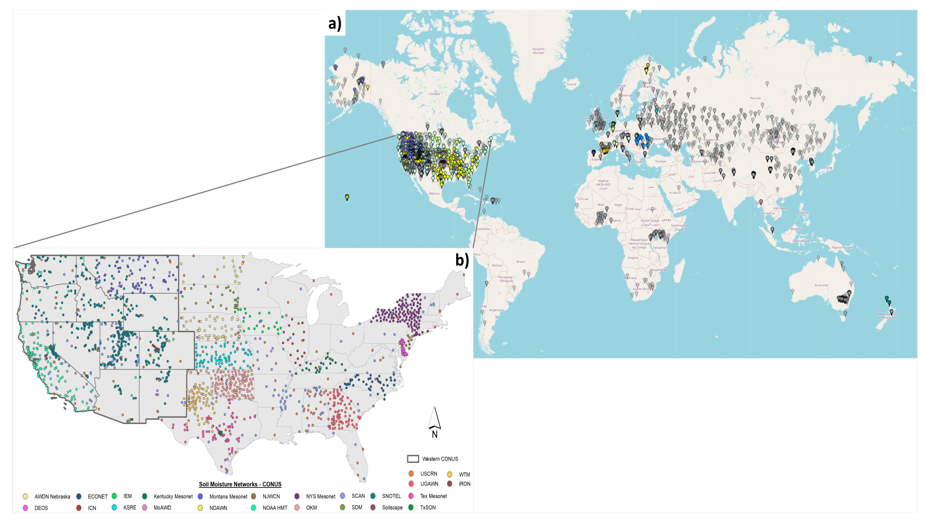
3.2.2. Ground-Based Soil Moisture Measurements
3.2.3. Integration of Satellite and Ground-Based Observational Data for SM Monitoring Dynamics
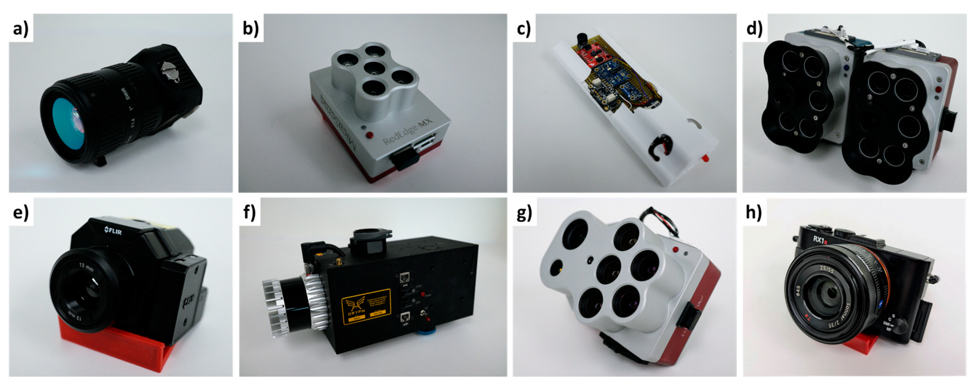
3.2.4. Remote Sensing: Unmanned Aerial Vehicle (UAV) for Monitoring Soil Moisture Dynamics
- RGB cameras: which capture images in the visible spectrum primarily for vegetation mapping, offering high-quality RGB band images at a relatively low cost [77];
- Multispectral and hyperspectral cameras: capturing images across multiple spectral bands to compute various spectral indices (Enhanced Vegetation Index (EVI), Soil Adjusted Vegetation Index (SAVI), Normalized Difference Vegetation Index (NDVI), and others.) for assessing vegetation conditions, soil physical parameters, and SM content; this image generally require radiometric and atmospheric corrections [78,79];
- Thermal cameras: commonly used for mapping temperature, evapotranspiration, and SM by capturing infrared radiation emitted by the targets, allowing for temperature differences and thermal anomalies identification. Thermal cameras have been introduced for SM mapping by utilizing the relationship between water content and land surface temperature (LST) [80], with their most common application in agriculture for monitoring crop water stress and irrigation management [81];
- Shortwave near infrared (SWIR) camera: helps generate various SWIR reflectance indices that correlate more closely with the total water content of the vegetation pores and infer SM content [82];
- LIDAR: significantly applied for 3D reconstruction, flood monitoring, snow depth, and erosion assessments, though they are costlier and require ground filtering corrections [83].
3.3. Modeling
3.3.1. Algorithms
3.3.2. Numerical Modeling
3.3.3. Soil Moisture Modeling: Relationship to Soil, Vegetation, and Climate
4. Conclusions and Recommendations
4.1. Conclusions
- In our review, we identified a significant gap in the application of SM as a performance indicator to assess the impact of ecological restoration in areas affected by disturbances in semi-arid zones. Although we identified great technological development to measure SM, this gap highlights the need to focus research and develop methodologies that incorporate SM measurements to evaluate and improve restoration results in semi-arid ecosystems; e.g., Proctor et al., (2022) [104] highlighted the importance of SM instead of precipitation for crops yields and other purposes.
- The integration of DL and ML algorithms has significantly enhanced SM analytics, facilitating detailed spatiotemporal monitoring; additionally, the ISMN plays a pivotal role in harmonizing in situ data, essential for validating satellite observations.
- ML techniques, such as RF, SVM, and ANN, are increasingly applied due to their robustness in handling complex, non-linear relationships between SM and various environmental covariates; the integration of these algorithms enhances the resolution and accuracy of SM estimates.
- Our review underscores the substantial potential of ML algorithms in the geospatial monitoring of SM across regional and local scales, integrating in situ and satellite remote sensing data, notably through the widespread use of the RF algorithm in conjunction with the SMAP satellite product.
- There is also a promising trend towards developing algorithms that reduce reliance on auxiliary data, or utilize readily available remote sensing observations to improve SM monitoring capabilities.
- Ground-based soil moisture (SM) measurements are indispensable for the calibration and validation of remote sensing data and models, providing precise and localized information critical for ecological restoration and sustainable land management in semi-arid ecosystems. Our analysis underscores the extensive yet varied global distribution of in situ SM measurement networks, highlighting their pivotal role in enhancing the reliability of satellite-derived SM estimates and supporting climate model reanalysis. Notable examples, such as the ISMN and NCSMMN, demonstrate the integration of large-scale networks that offer real-time, high-quality data essential for comprehensive SM monitoring.
- The use of empirical, semi-empirical, and physical models significantly enhances the accuracy and utility of soil moisture (SM) estimates. Furthermore, the integration of satellite products such as SMAP/Sentinel, CGLS Sentinel-1, and ERA5-Land contributes to robust, detailed, and precise SM monitoring. This comprehensive approach, combining diverse data sources and modeling techniques, establishes an effective framework for addressing the complex dynamics of SM.
- UAVs offer promising potential for detailed SM monitoring due to their high-resolution capabilities. However, their high costs, expertise requirements, and dependence on weather conditions, along with limited resources, necessitate the development of methods to integrate UAV data with satellite observations. This approach can provide reliable estimates over vast tracts of land typical of the western US, optimizing both feasibility and cost-effectiveness in large-scale SM monitoring. Additionally, a gap was identified to demonstrate how RGB/multispectral imaging can be used to “substitute” the use of expensive shortwave infrared (SWIR) sensors. Demonstrating how RGB or multispectral imaging can effectively replace SM estimation with SWIR in UAVs presents an important area for future research.
- Despite advancements, challenges remain, particularly in the application of interpolation methods and the need for high-resolution, precise data for disturbed vegetation in semi-arid regions.
4.2. Recommendations for Future Research
- Future efforts should focus on standardized protocols and guidelines for the integration of SM measurements into ecological restoration projects with a particular emphasis on semi-arid landscapes. These protocols should include the development of comprehensive methodologies that not only incorporate advanced remote sensing technologies but also ensure the consistency and comparability of data across different scales and regions. Establishing such protocols will enhance the reliability of SM as a performance indicator, enabling more accurate assessment and improvement of restoration outcomes in semi-arid ecosystems.
- Upscaling applications (from the field measurements to the UAV to the satellite) should be strengthened so that SM monitoring can be implemented at different scales. While UAV estimations of SM provide high-resolution data, their limited scope is insufficient for covering the vast landscapes characteristic of the western USA. Future research should focus on integrating UAV-derived SM data with satellite observations to enhance spatial coverage and data reliability. Additionally, the potential of using cost-effective RGB or multispectral imagery as substitutes for expensive SWIR sensors in UAVs should be investigated to ensure economic feasibility without compromising data quality.
- There are various national and regional land use and cover mapping efforts for the Western US that provide estimates of canopy cover useful for assessing ecological restoration performance. However, it is crucial to identify and demonstrate which of these products offer the highest accuracy.
- Assessing the spatiotemporal dynamics of soil moisture (SM) as a performance indicator of ecological restoration is a significant future research challenge and opportunity. For instance, it is relevant to identify and measure which specific types of restoration practices effectively improve SM in particular landscapes.
Author Contributions
Funding
Data Availability Statement
Acknowledgments
Conflicts of Interest
References
- Shen, M.; Zhang, J.; Zhang, S.; Zhang, H.; Sun, R.; Zhang, Y. Seasonal variations in the influence of vegetation cover on soil water on the loess hillslope. J. Mt. Sci. 2020, 17, 2148–2160. [Google Scholar] [CrossRef]
- Li, Z.-L.; Leng, P.; Zhou, C.; Chen, K.-S.; Zhou, F.-C.; Shang, G.-F. Soil moisture retrieval from remote sensing measurements: Current knowledge and directions for the future. Earth-Sci. Rev. 2021, 218, 103673. [Google Scholar] [CrossRef]
- Ahlström, A.; Raupach, M.R.; Schurgers, G.; Smith, B.; Arneth, A.; Jung, M.; Reichstein, M.; Canadell, J.G.; Friedlingstein, P.; Jain, A.K.; et al. Carbon cycle. The dominant role of semi-arid ecosystems in the trend and variability of the land CO2 sink. Science 2015, 348, 895–899. [Google Scholar] [CrossRef] [PubMed]
- Garcia-Franco, N.; Hobley, E.; Hübner, R.; Wiesmeier, M. Chapter 23—Climate-Smart Soil Management in Semiarid Regions. In Soil Management and Climate Change; Muñoz, M.Á., Zornoza, R., Eds.; Academic Press: Cambridge, MA, USA, 2018; pp. 349–368. [Google Scholar]
- Brandt, M.; Hiernaux, P.; Rasmussen, K.; Mbow, C.; Kergoat, L.; Tagesson, T.; Ibrahim, Y.Z.; Wélé, A.; Tucker, C.J.; Fensholt, R. Assessing woody vegetation trends in Sahelian drylands using MODIS based seasonal metrics. Remote Sens. Environ. 2016, 183, 215–225. [Google Scholar] [CrossRef]
- Han, Q.; Zeng, Y.; Zhang, L.; Cira, C.-I.; Prikaziuk, E.; Duan, T.; Wang, C.; Szabó, B.; Manfreda, S.; Zhuang, R.; et al. Ensemble of optimised machine learning algorithms for predicting surface soil moisture content at a global scale. Geosci. Model Dev. 2023, 16, 5825–5845. [Google Scholar] [CrossRef]
- Ye, N.; Walker, J.P.; Wu, X.; De Jeu, R.; Gao, Y.; Jackson, T.J.; Jonard, F.; Kim, E.; Merlin, O.; Pauwels, V.R.N.; et al. The Soil Moisture Active Passive Experiments: Validation of the SMAP Products in Australia. IEEE Trans. Geosci. Remote Sens. 2021, 59, 2922–2939. [Google Scholar] [CrossRef]
- Leduc-Leballeur, M.; Picard, G.; Macelloni, G.; Mialon, A.; Kerr, Y.H. Melt in Antarctica derived from Soil Moisture and Ocean Salinity (SMOS) observations at L band. Cryosphere 2020, 14, 539–548. [Google Scholar] [CrossRef]
- Zabolotskikh, E.V.; Khvorostovsky, K.S.; Chapron, B. An Advanced Algorithm to Retrieve Total Atmospheric Water Vapor Content From the Advanced Microwave Scanning Radiometer Data Over Sea Ice and Sea Water Surfaces in the Arctic. IEEE Trans. Geosci. Remote Sens. 2020, 58, 3123–3135. [Google Scholar] [CrossRef]
- Zhuang, R.; Manfreda, S.; Zeng, Y.; Su, Z.; Ben Dor, E.; Petropoulos, G.P. Chapter 7—Soil moisture monitoring using unmanned aerial system. In Unmanned Aerial Systems for Monitoring Soil, Vegetation, and Riverine Environments; Manfreda, S., Ben Dor, E., Eds.; Elsevier: Amsterdam, The Netherlands, 2023; pp. 179–200. [Google Scholar]
- Bian, J.; Zhang, Z.; Chen, J.; Chen, H.; Cui, C.; Li, X.; Chen, S.; Fu, Q. Simplified Evaluation of Cotton Water Stress Using High Resolution Unmanned Aerial Vehicle Thermal Imagery. Remote Sens. 2019, 11, 267. [Google Scholar] [CrossRef]
- Beene, D.; Zhang, S.; Paulus, G. Workflow for hydrologic modelling with sUAS-acquired aerial imagery. Geocarto Int. 2021, 36, 1346–1364. [Google Scholar] [CrossRef]
- Yu, J.-W.; Yoon, Y.-W.; Baek, W.-K.; Jung, H.-S. Forest Vertical Structure Mapping Using Two-Seasonal Optic Images and LiDAR DSM Acquired from UAV Platform through Random Forest, XGBoost, and Support Vector Machine Approaches. Remote Sens. 2021, 13, 4282. [Google Scholar] [CrossRef]
- Brook, A.; De Micco, V.; Battipaglia, G.; Erbaggio, A.; Ludeno, G.; Catapano, I.; Bonfante, A. A smart multiple spatial and temporal resolution system to support precision agriculture from satellite images: Proof of concept on Aglianico vineyard. Remote Sens. Environ. 2020, 240, 111679. [Google Scholar] [CrossRef]
- Zhang, Z.; Zhu, L. A Review on Unmanned Aerial Vehicle Remote Sensing: Platforms, Sensors, Data Processing Methods, and Applications. Drones 2023, 7, 398. [Google Scholar] [CrossRef]
- Ye, N.; Walker, J.P.; Gao, Y.; PopStefanija, I.; Hills, J. Comparison Between Thermal-Optical and L-Band Passive Microwave Soil Moisture Remote Sensing at Farm Scales: Towards UAV-Based Near-Surface Soil Moisture Mapping. IEEE J. Sel. Top. Appl. Earth Obs. Remote Sens. 2024, 17, 633–642. [Google Scholar] [CrossRef]
- Li, B.; Wang, C.; Gu, X.; Zhou, X.; Ma, M.; Li, L.; Feng, Z.; Ding, T.; Li, X.; Jiang, T.; et al. Accuracy calibration and evaluation of capacitance-based soil moisture sensors for a variety of soil properties. Agric. Water Manag. 2022, 273, 107913. [Google Scholar] [CrossRef]
- Kim, H.; Cosh, M.H.; Bindlish, R.; Lakshmi, V. Field evaluation of portable soil water content sensors in a sandy loam. Vadose Zone J. 2020, 19, e20033. [Google Scholar] [CrossRef]
- Han, Q.; Zeng, Y.; Zhang, L.; Wang, C.; Prikaziuk, E.; Niu, Z.; Su, B. Global long term daily 1 km surface soil moisture dataset with physics informed machine learning. Sci. Data 2023, 10, 101. [Google Scholar] [CrossRef] [PubMed]
- O, S.; Orth, R. Global soil moisture data derived through machine learning trained with in-situ measurements. Sci. Data 2021, 8, 170. [Google Scholar] [CrossRef]
- Dorigo, W.; Himmelbauer, I.; Aberer, D.; Schremmer, L.; Petrakovic, I.; Zappa, L.; Preimesberger, W.; Xaver, A.; Annor, F.; Ardö, J.; et al. The International Soil Moisture Network: Serving Earth system science for over a decade. Hydrol. Earth Syst. Sci. 2021, 25, 5749–5804. [Google Scholar] [CrossRef]
- Gruber, A.; De Lannoy, G.; Albergel, C.; Al-Yaari, A.; Brocca, L.; Calvet, J.-C.; Colliander, A.; Cosh, M.; Crow, W.; Dorigo, W.; et al. Validation practices for satellite soil moisture retrievals: What are (the) errors? Remote Sens. Environ. 2020, 244, 111806. [Google Scholar] [CrossRef]
- Prăvălie, R. Exploring the multiple land degradation pathways across the planet. Earth-Sci. Rev. 2021, 220, 103689. [Google Scholar] [CrossRef]
- FAO Map Catalog—Food and Agriculture Organization of the United Nations. Available online: https://data.apps.fao.org/map/catalog/static/search?keyword=aridity (accessed on 17 April 2024).
- Scholes, R.J. The Future of Semi-Arid Regions: A Weak Fabric Unravels. Climate 2020, 8, 43. [Google Scholar] [CrossRef]
- ILRI; IUCN; FAO; WWF; UNEP; ILC. Rangelands Atlas; International Livestock Research Institute: Nairobi, Kenya, 2021; Available online: https://www.ilri.org/knowledge/publications/rangelands-atlas (accessed on 8 April 2024).
- Safriel, U.; Adeel, Z.; Niemeijer, D.; Puigdefabregas, J.; White, R.; Lal, R.; Winslow, M.; Ziedler, J.; Prince, S.; Archer, E. Dryland systems. In Ecosystems and Human Well-Being: Current State and Trends; Island Press: Washington, DC, USA, 2005; pp. 623–662. [Google Scholar]
- USDA ERS—Drought in the Western United States. Available online: https://www.ers.usda.gov/newsroom/trending-topics/drought-in-the-western-united-states/ (accessed on 7 May 2024).
- Morris, L.R.; Rowe, R.J. Historical land use and altered habitats in the Great Basin. J. Mammal. 2014, 95, 1144–1156. [Google Scholar] [CrossRef]
- Green, A.W.; Aldridge, C.L.; O’donnell, M.S. Investigating impacts of oil and gas development on greater sage-grouse. J. Wildl. Manag. 2017, 81, 46–57. [Google Scholar] [CrossRef]
- Rigge, M.; Homer, C.; Cleeves, L.; Meyer, D.K.; Bunde, B.; Shi, H.; Xian, G.; Schell, S.; Bobo, M. Quantifying Western U.S. Rangelands as Fractional Components with Multi-Resolution Remote Sensing and In Situ Data. Remote Sens. 2020, 12, 412. [Google Scholar] [CrossRef]
- Rigge, M.; Homer, C.; Shi, H.; Meyer, D.; Bunde, B.; Granneman, B.; Postma, K.; Danielson, P.; Case, A.; Xian, G. Rangeland Fractional Components across the Western United States from 1985 to 2018. Remote Sens. 2021, 13, 813. [Google Scholar] [CrossRef]
- Carlucci, M.B.; Brancalion, P.H.S.; Rodrigues, R.R.; Loyola, R.; Cianciaruso, M.V. Functional traits and ecosystem services in ecological restoration. Restor. Ecol. 2020, 28, 1372–1383. [Google Scholar] [CrossRef]
- Smith, T.C.; Bishop, T.B.B.; Duniway, M.C.; Villarreal, M.L.; Knight, A.C.; Munson, S.M.; Waller, E.K.; Jensen, R.; Gill, R.A. Biophysical factors control invasive annual grass hot spots in the Mojave Desert. Biol. Invasions 2023, 25, 3839–3858. [Google Scholar] [CrossRef]
- Staub, J.; Chatterton, J.; Bushman, S.; Johnson, D.; Jones, T.; Larson, S.; Robins, J.; Monaco, T. A History of Plant Improvement by the USDA-ARS Forage and Range Research Laboratory for Rehabilitation of Degraded Western U.S. Rangelands. Rangelands 2016, 38, 233–240. [Google Scholar] [CrossRef]
- Jones, T.A. Ecologically Appropriate Plant Materials for Restoration Applications. BioScience 2013, 63, 211–219. [Google Scholar] [CrossRef]
- Copeland, S.M.; Munson, S.M.; Pilliod, D.S.; Welty, J.L.; Bradford, J.B.; Butterfield, B.J. Long-term trends in restoration and associated land treatments in the southwestern United States. Restor. Ecol. 2018, 26, 311–322. [Google Scholar] [CrossRef]
- Benedict, T.D.; Boyte, S.P.; Dahal, D.; Shrestha, D.; Parajuli, S.; Megard, L.J. Extracting exotic annual grass phenology and climate relations in western U.S. rangeland ecoregions. Biol Invasions 2023, 25, 2023–2041. [Google Scholar] [CrossRef]
- Remington, T.E.; Deibert, P.A.; Hanser, S.E.; Davis, D.M.; Robb, L.A.; Welty, J.L. Sagebrush Conservation Strategy—Challenges to Sagebrush Conservation; U.S. Geological Survey: Reston, VA, USA, 2021. [Google Scholar]
- Dewitz, J. National Land Cover Database (NLCD) 2021 Products. 2023. Available online: https://www.sciencebase.gov/catalog/item/647626cbd34e4e58932d9d4e (accessed on 17 April 2024).
- Tilley, D.; Tilley, N.; Fund, A.; Wolf, M. Seedling growth and competition of a late-seral, native perennial grass and 2 early-seral, native forbs in the presence of 2 densities of the invasive annual grass Bromus tectorum L. (Poaceae). Nativ. Plants J. 2020, 21, 299–311. [Google Scholar] [CrossRef]
- Valliere, J.M.; Ruscalleda Alvarez, J.; Cross, A.T.; Lewandrowski, W.; Riviera, F.; Stevens, J.C.; Tomlinson, S.; Tudor, E.P.; Wong, W.S.; Yong, J.W.H.; et al. Restoration ecophysiology: An ecophysiological approach to improve restoration strategies and outcomes in severely disturbed landscapes. Restor. Ecol. 2022, 30, e13571. [Google Scholar] [CrossRef]
- Ullah, H.; Khan, S.M.; Jaremko, M.; Jahangir, S.; Ullah, Z.; Ali, I.; Ahmad, Z.; Badshah, H. Vegetation assessments under the influence of environmental variables from the Yakhtangay Hill of the Hindu-Himalayan range, North Western Pakistan. Sci. Rep. 2022, 12, 20973. [Google Scholar] [CrossRef]
- Forkel, M.; Schmidt, L.; Zotta, R.-M.; Dorigo, W.; Yebra, M. Estimating leaf moisture content at global scale from passive microwave satellite observations of vegetation optical depth. Hydrol. Earth Syst. Sci. 2023, 27, 39–68. [Google Scholar] [CrossRef]
- Duarte, E.; Zagal, E.; Barrera, J.A.; Dube, F.; Casco, F.; Hernández, A.J. Digital mapping of soil organic carbon stocks in the forest lands of Dominican Republic. Eur. J. Remote Sens. 2022, 55, 213–231. [Google Scholar] [CrossRef]
- Yang, L.; Wei, W.; Chen, L.; Chen, W.; Wang, J. Response of temporal variation of soil moisture to vegetation restoration in semi-arid Loess Plateau, China. CATENA 2014, 115, 123–133. [Google Scholar] [CrossRef]
- Mohanty, B.P.; Cosh, M.H.; Lakshmi, V.; Montzka, C. Soil Moisture Remote Sensing: State-of-the-Science. Vadose Zone J. 2017, 16, 1–9. [Google Scholar] [CrossRef]
- Wang, Y.; Zhao, H.; Fan, J.; Wang, C.; Ji, X.; Jin, D.; Chen, J. A Review of Earth’s Surface Soil Moisture Retrieval Models via Remote Sensing. Water 2023, 15, 3757. [Google Scholar] [CrossRef]
- Conde, V.; Nico, G.; Catalão, J. Comparison of In-Field Measurements and INSAR Estimates of Soil Moisture: Inversion Strategies of Interferometric Data. In Proceedings of the IGARSS 2019—2019 IEEE International Geoscience and Remote Sensing Symposium, Yokohama, Japan, 28 July–2 August 2019; pp. 6186–6189. [Google Scholar]
- Shakya, A.K.; Ramola, A.; Kandwal, A.; Vidyarthi, A. Soil moisture sensor for agricultural applications inspired from state of art study of surfaces scattering models & semi-empirical soil moisture models. J. Saudi Soc. Agric. Sci. 2021, 20, 559–572. [Google Scholar] [CrossRef]
- Singh, A.; Gaurav, K.; Meena, G.K.; Kumar, S. Estimation of Soil Moisture Applying Modified Dubois Model to Sentinel-1; A Regional Study from Central India. Remote Sens. 2020, 12, 2266. [Google Scholar] [CrossRef]
- Dubois, P.C.; van Zyl, J.; Engman, T. Measuring soil moisture with imaging radars. IEEE Trans. Geosci. Remote Sens. 1995, 33, 915–926. [Google Scholar] [CrossRef]
- Zribi, M.; Muddu, S.; Bousbih, S.; Al Bitar, A.; Tomer, S.K.; Baghdadi, N.; Bandyopadhyay, S. Analysis of L-Band SAR Data for Soil Moisture Estimations over Agricultural Areas in the Tropics. Remote Sens. 2019, 11, 1122. [Google Scholar] [CrossRef]
- Rawat, K.S.; Sehgal, V.K.; Pradhan, S.; Ray, S.S. Semi-empirical model for retrieval of soil moisture using RISAT-1 C-Band SAR data over a sub-tropical semi-arid area of Rewari district, Haryana (India). J. Earth Syst. Sci. 2018, 127, 18. [Google Scholar] [CrossRef]
- Hoskera, A.K.; Nico, G.; Irshad Ahmed, M.; Whitbread, A. Accuracies of Soil Moisture Estimations Using a Semi-Empirical Model over Bare Soil Agricultural Croplands from Sentinel-1 SAR Data. Remote Sens. 2020, 12, 1664. [Google Scholar] [CrossRef]
- Luo, D.; Wen, X.; Li, S. An improved method for estimating soil moisture over cropland using SAR and optical data. Earth Sci Inform. 2023, 16, 1909–1916. [Google Scholar] [CrossRef]
- Sadeghi, M.; Jones, S.B.; Philpot, W.D. A linear physically-based model for remote sensing of soil moisture using short wave infrared bands. Remote Sens. Environ. 2015, 164, 66–76. [Google Scholar] [CrossRef]
- Kim, S.-B.; Huang, H.; Liao, T.-H.; Colliander, A. Estimating Vegetation Water Content and Soil Surface Roughness Using Physical Models of L-Band Radar Scattering for Soil Moisture Retrieval. Remote Sens. 2018, 10, 556. [Google Scholar] [CrossRef]
- Das, N.N.; Entekhabi, D.; Dunbar, R.S.; Chaubell, M.J.; Colliander, A.; Yueh, S.; Jagdhuber, T.; Chen, F.; Crow, W.; O’Neill, P.E.; et al. The SMAP and Copernicus Sentinel 1A/B microwave active-passive high resolution surface soil moisture product. Remote Sens. Environ. 2019, 233, 111380. [Google Scholar] [CrossRef]
- Zheng, C.; Jia, L.; Zhao, T. A 21-year dataset (2000–2020) of gap-free global daily surface soil moisture at 1-km grid resolution. Sci. Data 2023, 10, 139. [Google Scholar] [CrossRef] [PubMed]
- Naeimi, V.; Bartalis, Z.; Wagner, W. ASCAT Soil Moisture: An Assessment of the Data Quality and Consistency with the ERS Scatterometer Heritage. J. Hydrometeorol. 2009, 10, 555–563. [Google Scholar] [CrossRef]
- Vergopolan, N.; Chaney, N.W.; Pan, M.; Sheffield, J.; Beck, H.E.; Ferguson, C.R.; Torres-Rojas, L.; Sadri, S.; Wood, E.F. SMAP-HydroBlocks, a 30-m satellite-based soil moisture dataset for the conterminous US. Sci. Data 2021, 8, 264. [Google Scholar] [CrossRef] [PubMed]
- Bauer-Marschallinger, B.; Freeman, V.; Cao, S.; Paulik, C.; Schaufler, S.; Stachl, T.; Modanesi, S.; Massari, C.; Ciabatta, L.; Brocca, L.; et al. Toward Global Soil Moisture Monitoring With Sentinel-1: Harnessing Assets and Overcoming Obstacles. IEEE Trans. Geosci. Remote Sens. 2019, 57, 520–539. [Google Scholar] [CrossRef]
- ONeill, P.E.; Chan, S.; Njoku, E.G.; Jackson, T.; Bindlish, R.; Chaubell, M.J. SMAP Enhanced L3 Radiometer Global Daily 9 km EASE-Grid Soil Moisture, Version 4. 2020. Available online: https://nsidc.org/data/SPL3SMP_E/versions/4 (accessed on 11 March 2024).
- Wigneron, J.-P.; Li, X.; Frappart, F.; Fan, L.; Al-Yaari, A.; De Lannoy, G.; Liu, X.; Wang, M.; Le Masson, E.; Moisy, C. SMOS-IC data record of soil moisture and L-VOD: Historical development, applications and perspectives. Remote Sens. Environ. 2021, 254, 112238. [Google Scholar] [CrossRef]
- Muñoz-Sabater, J.; Dutra, E.; Agustí-Panareda, A.; Albergel, C.; Arduini, G.; Balsamo, G.; Boussetta, S.; Choulga, M.; Harrigan, S.; Hersbach, H.; et al. ERA5-Land: A state-of-the-art global reanalysis dataset for land applications. Earth Syst. Sci. Data 2021, 13, 4349–4383. [Google Scholar] [CrossRef]
- Zhang, Y.; Liang, S.; Ma, H.; He, T.; Wang, Q.; Li, B.; Xu, J.; Zhang, G.; Liu, X.; Xiong, C. Generation of global 1 km daily soil moisture product from 2000 to 2020 using ensemble learning. Earth Syst. Sci. Data 2023, 15, 2055–2079. [Google Scholar] [CrossRef]
- NIDIS. National Integrated Drought Information System: A Strategy for the National Coordinated Soil Moisture Monitoring Network. 2021. Available online: https://www.drought.gov/sites/default/files/2021-06/NCSMMN-Strategy-Final-May-2021.pdf (accessed on 14 March 2024).
- Chaney, N.W.; Torres-Rojas, L.; Vergopolan, N.; Fisher, C.K. HydroBlocks v0.2: Enabling a field-scale two-way coupling between the land surface and river networks in Earth system models. Geosci. Model Dev. 2021, 14, 6813–6832. [Google Scholar] [CrossRef]
- Yuan, S.; Quiring, S.M.; Leasor, Z.T. Historical Changes in Surface Soil Moisture Over the Contiguous United States: An Assessment of CMIP6. Geophys. Res. Lett. 2021, 48, e2020GL089991. [Google Scholar] [CrossRef]
- Ford, T.W.; Quiring, S.M.; Zhao, C.; Leasor, Z.T.; Landry, C. Triple Collocation Evaluation of In Situ Soil Moisture Observations from 1200+ Stations as part of the U.S. National Soil Moisture Network. J. Hydrometeorol. 2020, 21, 2537–2549. [Google Scholar] [CrossRef]
- Webmaster, C.P.C. Climate Prediction Center. Available online: https://www.cpc.ncep.noaa.gov/ (accessed on 24 April 2024).
- Marinescu, P.J.; Abdi, D.; Hilburn, K.; Jankov, I.; Lin, L.-F. An Evaluation of NOAA Modeled and In Situ Soil Moisture Values and Variability across the Continental United States. Weather. Forecast. 2024, 39, 523–540. [Google Scholar] [CrossRef]
- Li, B.; Rodell, M.; Kumar, S.; Beaudoing, H.K.; Getirana, A.; Zaitchik, B.F.; de Goncalves, L.G.; Cossetin, C.; Bhanja, S.; Mukherjee, A.; et al. Global GRACE Data Assimilation for Groundwater and Drought Monitoring: Advances and Challenges. Water Resour. Res. 2019, 55, 7564–7586. [Google Scholar] [CrossRef]
- McDonough, K.R.; Hutchinson, S.L.; Hutchinson, J.M.S.; Case, J.L.; Rahmani, V. Validation and assessment of SPoRT-LIS surface soil moisture estimates for water resources management applications. J. Hydrol. 2018, 566, 43–54. [Google Scholar] [CrossRef]
- Fleming, S.W.; Zukiewicz, L.; Strobel, M.L.; Hofman, H.; Goodbody, A.G. SNOTEL, the Soil Climate Analysis Network, and water supply forecasting at the Natural Resources Conservation Service: Past, present, and future. JAWRA J. Am. Water Resour. Assoc. 2023, 59, 585–599. [Google Scholar] [CrossRef]
- Paridad, P.; Dal Sasso, S.F.; Pizarro, A.; Mita, L.; Fiorentino, M.; Margiotta, M.R.; Faridani, F.; Farid, A.; Manfreda, S. Estimation of soil moisture from UAS platforms using RGB and thermal imaging sensors in arid and semi-arid regions. Acta Hortic. 2022, 1335, 339–348. [Google Scholar] [CrossRef]
- Ge, X.; Ding, J.; Jin, X.; Wang, J.; Chen, X.; Li, X.; Liu, J.; Xie, B. Estimating Agricultural Soil Moisture Content through UAV-Based Hyperspectral Images in the Arid Region. Remote Sens. 2021, 13, 1562. [Google Scholar] [CrossRef]
- Hernandez, A.; Jensen, K.; Larson, S.; Larsen, R.; Rigby, C.; Johnson, B.; Spickermann, C.; Sinton, S. Using Unmanned Aerial Vehicles and Multispectral Sensors to Model Forage Yield for Grasses of Semiarid Landscapes. Grasses 2024, 3, 84–109. [Google Scholar] [CrossRef]
- Hsu, W.-L.; Chang, K.-T. Cross-estimation of Soil Moisture Using Thermal Infrared Images with Different Resolutions. Sens. Mater. 2019, 31, 387. [Google Scholar] [CrossRef]
- Bellvert, J.; Zarco-Tejada, P.J.; Marsal, J.; Girona, J.; González-Dugo, V.; Fereres, E. Vineyard irrigation scheduling based on airborne thermal imagery and water potential thresholds. Aust. J. Grape Wine Res. 2016, 22, 307–315. [Google Scholar] [CrossRef]
- Levy, J.S.; Johnson, J.T.E. Remote Soil Moisture Measurement from Drone-Borne Reflectance Spectroscopy: Applications to Hydroperiod Measurement in Desert Playas. Remote Sens. 2021, 13, 1035. [Google Scholar] [CrossRef]
- Acharya, B.S.; Bhandari, M.; Bandini, F.; Pizarro, A.; Perks, M.; Joshi, D.R.; Wang, S.; Dogwiler, T.; Ray, R.L.; Kharel, G.; et al. Unmanned Aerial Vehicles in Hydrology and Water Management: Applications, Challenges, and Perspectives. Water Resour. Res. 2021, 57, e2021WR029925. [Google Scholar] [CrossRef]
- Ge, X.; Wang, J.; Ding, J.; Cao, X.; Zhang, Z.; Liu, J.; Li, X. Combining UAV-based hyperspectral imagery and machine learning algorithms for soil moisture content monitoring. PeerJ 2019, 7, e6926. [Google Scholar] [CrossRef] [PubMed]
- Zhang, W.; Yi, S.; Qin, Y.; Sun, Y.; Shangguan, D.; Meng, B.; Li, M.; Zhang, J. Effects of Patchiness on Surface Soil Moisture of Alpine Meadow on the Northeastern Qinghai-Tibetan Plateau: Implications for Grassland Restoration. Remote Sens. 2020, 12, 4121. [Google Scholar] [CrossRef]
- Lu, F.; Sun, Y.; Hou, F. Using UAV Visible Images to Estimate the Soil Moisture of Steppe. Water 2020, 12, 2334. [Google Scholar] [CrossRef]
- Wen, Y.; Zhao, J.; Zhu, G.; Xu, R.; Yang, J. Evaluation of the RF-Based Downscaled SMAP and SMOS Products Using Multi-Source Data over an Alpine Mountains Basin, Northwest China. Water 2021, 13, 2875. [Google Scholar] [CrossRef]
- Nasta, P.; Szabó, B.; Romano, N. Evaluation of pedotransfer functions for predicting soil hydraulic properties: A voyage from regional to field scales across Europe. J. Hydrol. Reg. Stud. 2021, 37, 100903. [Google Scholar] [CrossRef]
- Araya, S.N.; Ghezzehei, T.A. Using Machine Learning for Prediction of Saturated Hydraulic Conductivity and Its Sensitivity to Soil Structural Perturbations. Water Resour. Res. 2019, 55, 5715–5737. [Google Scholar] [CrossRef]
- Adab, H.; Morbidelli, R.; Saltalippi, C.; Moradian, M.; Ghalhari, G.A. Machine Learning to Estimate Surface Soil Moisture from Remote Sensing Data. Water 2020, 12, 3223. [Google Scholar] [CrossRef]
- Chakraborty, D.; Başağaoğlu, H.; Alian, S.; Mirchi, A.; Moriasi, D.N.; Starks, P.J.; Verser, J.A. Multiscale extrapolative learning algorithm for predictive soil moisture modeling & applications. Expert Syst. Appl. 2023, 213, 119056. [Google Scholar] [CrossRef]
- Duc, L.; Sawada, Y. A signal-processing-based interpretation of the Nash–Sutcliffe efficiency. Hydrol. Earth Syst. Sci. 2023, 27, 1827–1839. [Google Scholar] [CrossRef]
- Padarian, J.; Minasny, B.; McBratney, A.B. Machine learning and soil sciences: A review aided by machine learning tools. Soil 2020, 6, 35–52. [Google Scholar] [CrossRef]
- Deng, X.; Chen, X.; Ma, W.; Ren, Z.; Zhang, M.; Grieneisen, M.L.; Long, W.; Ni, Z.; Zhan, Y.; Lv, X. Baseline map of organic carbon stock in farmland topsoil in East China. Agric. Ecosyst. Environ. 2018, 254, 213–223. [Google Scholar] [CrossRef]
- Jeong, G.; Oeverdieck, H.; Park, S.J.; Huwe, B.; Ließ, M. Spatial soil nutrients prediction using three supervised learning methods for assessment of land potentials in complex terrain. CATENA 2017, 154, 73–84. [Google Scholar] [CrossRef]
- Yuan, S.; Quiring, S.M. Comparison of three methods of interpolating soil moisture in Oklahoma. Int. J. Climatol. 2017, 37, 987–997. [Google Scholar] [CrossRef]
- Rani, A.; Kumar, N.; Kumar, J.; Kumar, J.; Sinha, N.K. Machine learning for soil moisture assessment. Cogn. Data Sci. Sustain. Comput. 2022, 143–168. [Google Scholar] [CrossRef]
- Vishwakarma, D.K.; Kumar, R.; Abed, S.A.; Al-Ansari, N.; Kumar, A.; Kushwaha, N.L.; Yadav, D.; Kumawat, A.; Kuriqi, A.; Alataway, A.; et al. Modeling of soil moisture movement and wetting behavior under point-source trickle irrigation. Sci. Rep. 2023, 13, 14981. [Google Scholar] [CrossRef]
- Arnold, J.G.; Srinivasan, R.; Muttiah, R.S.; Williams, J.R. Large area hydrologic modeling and assessment part I: Model development1. JAWRA J. Am. Water Resour. Assoc. 1998, 34, 73–89. [Google Scholar] [CrossRef]
- Lawrence, D.M.; Fisher, R.A.; Koven, C.D.; Oleson, K.W.; Swenson, S.C.; Bonan, G.; Collier, N.; Ghimire, B.; van Kampenhout, L.; Kennedy, D.; et al. The Community Land Model Version 5: Description of New Features, Benchmarking, and Impact of Forcing Uncertainty. J. Adv. Model. Earth Syst. 2019, 11, 4245–4287. [Google Scholar] [CrossRef]
- Hamman, J.J.; Nijssen, B.; Bohn, T.J.; Gergel, D.R.; Mao, Y. The Variable Infiltration Capacity model version 5 (VIC-5): Infrastructure improvements for new applications and reproducibility. Geosci. Model Dev. 2018, 11, 3481–3496. [Google Scholar] [CrossRef]
- Šimůnek, J.; Brunetti, G.; Jacques, D.; van Genuchten, M.T.; Šejna, M. Developments and applications of the HYDRUS computer software packages since 2016. Vadose Zone J. 2024, 23, e20310. [Google Scholar] [CrossRef]
- Dabrowska-Zielinska, K.; Musial, J.; Malinska, A.; Budzynska, M.; Gurdak, R.; Kiryla, W.; Bartold, M.; Grzybowski, P. Soil Moisture in the Biebrza Wetlands Retrieved from Sentinel-1 Imagery. Remote Sens. 2018, 10, 1979. [Google Scholar] [CrossRef]
- Proctor, J.; Rigden, A.; Chan, D.; Huybers, P. More accurate specification of water supply shows its importance for global crop production. Nat. Food 2022, 3, 753–763. [Google Scholar] [CrossRef] [PubMed]


| Dataset | Spatial Resolution | Temporal Availability | Advantages | Limitations |
|---|---|---|---|---|
| SMAP (Soil Moisture Active Passive) | 9 km (SMAP L4, L3_SSM_E 36 km (L3_SSM) | Daily and 3 h |
|
|
| Sentinel-1 | 5–20 m | 6–12 days |
|
|
| AMSR-E/AMSR2 | 5.4 km to 25 km | Daily |
|
|
| ERS SAR | Up to 25 km | 35 days (modifiable to 3 days in specific modes) |
|
|
| PALSAR-2 | 10–100 m | 14 days |
|
|
| Advanced Scatterometer (ASCAT) | 12.5 and 25 km grid | 2–3 days |
|
|
| SMOS (Soil Moisture and Ocean Salinity) | 25 km | 2–3 days |
|
|
| Network Name | Application | Advantages | Limitations | Application in Semi-Arid Lands |
|---|---|---|---|---|
| ISMN | Global monitoring, validation of satellite-derived SM estimates, climate model reanalysis. | Extensive global coverage, standardized data, advanced quality control methods, and long-term data availability. | Uneven global distribution sparse coverage in the tropics, southern hemisphere, and boreal regions. | Integrate with satellite data for comprehensive analysis. Expand network coverage in underrepresented regions. |
| NCSMMN | US-wide monitoring, weather forecasting, climate, agricultural, and ecological monitoring. | Large number of stations, integration with various data networks, and real-time data availability. | Limited to the US, varying sensor depths and data quality among different networks. | Standardize sensor depths and data quality. Use for national-scale SM monitoring and model validation. |
| SCAN | Agricultural and ecological monitoring in the US. | Long-term data, multiple sensor depths, and integration with other networks. | Limited to agricultural areas, data quality varies with station maintenance. | Regularly maintain and calibrate sensors. Use for detailed agricultural SM assessments. |
| SNOTEL | Monitoring snowpack and soil moisture in mountainous regions of the US. | High-quality data, critical for water resource management, and integration with SM networks. | Limited to mountainous regions, primarily focused on snowpack data. | Combine with other networks for comprehensive hydrological studies. |
| USCRN | Long-term climate monitoring, providing high-quality climate data, including SM. | High data accuracy, multiple sensor depths, and broad spatial coverage in the US. | High maintenance costs are limited to the US. | Use for long-term climate and SM trend analysis. Integrate with global networks for comprehensive climate studies. |
| Mesonet Networks (e.g., Oklahoma Mesonet) | Regional environmental monitoring, including SM, across various US states. | High spatial and temporal resolution, real-time data, integration with weather and climate models. | Regional focus, varying sensor depths, and data quality. | Standardize data collection protocols across states. Use for high-resolution regional SM monitoring and agricultural planning. |
| Product | Temporal Resolution | Time | Data | Description | Application in Semi-Arid Lands |
|---|---|---|---|---|---|
| National Oceanic and Atmospheric Administration (NOAA) Climate Prediction Center Soil Moisture Products | Daily and monthly | 2008–Present | Land-based Station | The model takes as forcing observed precipitation and temperature and calculates SM, evaporation, runoff, and snowpack www.cpc.ncep.noaa.gov, accessed on 24 April 2024 | Use for large-scale climate studies and trend analysis. Integrate with satellite data for comprehensive assessments. |
| Groundwater and Soil Moisture Conditions from GRACE Data Assimilation | 7 days | 2003–Present | Satellite | Generate groundwater and SM drought indicators each week. https://nasagrace.unl.edu/, accessed on 15 April 2024 | Combine with ground-based measurements for enhanced accuracy. |
| NASA SPoRT-LiS Soil Moisture Products | Daily | 2010–Present | Model Radar Satellite | Provides high-resolution (about 3-km) gridded SM products in real-time to support regional and local modeling and improve situational awareness. https://weather.ndc.nasa.gov/sport/, accessed on 8 April 2024 | Apply for regional SM monitoring, integrate with local in situ measurements for model validation. |
| Soil Moisture Monitoring Network. | Near real-time | 2018–present | Model | Provides high-resolution gridded SM products (4 km grid) derived from in situ SM measurements http://nationalsoilmoisture.com/, accessed on 7 May 2024 | Utilize for high-resolution local and regional studies. Ensure regular calibration and maintenance of in situ sensors. |
| Soil Climate Analysis Network (SCAN) | Near real-time | 1991–Present | Land-based Station | SM measurements are observed at the depths of 5, 10, 20, 50, and 100 cm. www.nrcs.usda.gov, accessed on 7 May 2024 | Focus on agricultural SM monitoring, integrate with other networks for broader applications. |
| North-American Land Data Assimilation System (NLDAS) | Near real-time | 1979–Present | Model | Reduce the errors in the stores of SM and energy which are often present in numerical weather prediction models. www.cpc.ncep.noaa.gov, accessed on 15 May 2024 | Employ for improving weather prediction models, integrate with satellite data for comprehensive climate studies. |
| Crop Condition and Soil Moisture Analytics Tool (Crop-CASMA) | daily with a 3-day delay. | 2015–present | Satellite | SM and vegetation index data derived from NASA SMAP and MODIS missions to assess conterminous US crop vegetation and SM conditions. https://nassgeo.csiss.gmu.edu/CropCASMA/, accessed on 17 May 2024 | Use for detailed agricultural SM monitoring, integrate with other agricultural data for comprehensive analysis. |
| Measurement Method | Influence of Soil Surface Characteristics | Relevant Soil Properties |
|---|---|---|
| Satellite Remote Sensing | Captures surface SM, influenced by soil texture, roughness, and vegetation | Soil texture, surface roughness, vegetation cover [64]. |
| UAV-Based Data Collection | High-resolution imagery sensitive to surface conditions, vegetation, and topography | Surface roughness, vegetation density, soil texture [15]. |
| In situ Measurements | Direct measurements that can be calibrated against soil structure and SM content | Soil porosity, texture, organic matter content [21]. |
| Empirical Models | Relies on statistical relationships, influenced by surface reflectance and vegetation | Reflectance properties, vegetation indices (NDVI, etc.) [51,103]. |
| Semi-Empirical Models | Combines physical principles and statistical relationships, considers surface conditions | Soil texture, surface roughness, vegetation cover [50,56]. |
| Physical Models | Based on fundamental physics, requires detailed surface properties for accuracy | Soil dielectric properties, surface roughness, moisture [57]. |
| Microwave Remote Sensing | Sensitive to surface SM content and roughness, can penetrate vegetation to some extent | SM content, vegetation cover, roughness [83]. |
Disclaimer/Publisher’s Note: The statements, opinions and data contained in all publications are solely those of the individual author(s) and contributor(s) and not of MDPI and/or the editor(s). MDPI and/or the editor(s) disclaim responsibility for any injury to people or property resulting from any ideas, methods, instructions or products referred to in the content. |
© 2024 by the authors. Licensee MDPI, Basel, Switzerland. This article is an open access article distributed under the terms and conditions of the Creative Commons Attribution (CC BY) license (https://creativecommons.org/licenses/by/4.0/).
Share and Cite
Duarte, E.; Hernandez, A. A Review on Soil Moisture Dynamics Monitoring in Semi-Arid Ecosystems: Methods, Techniques, and Tools Applied at Different Scales. Appl. Sci. 2024, 14, 7677. https://doi.org/10.3390/app14177677
Duarte E, Hernandez A. A Review on Soil Moisture Dynamics Monitoring in Semi-Arid Ecosystems: Methods, Techniques, and Tools Applied at Different Scales. Applied Sciences. 2024; 14(17):7677. https://doi.org/10.3390/app14177677
Chicago/Turabian StyleDuarte, Efrain, and Alexander Hernandez. 2024. "A Review on Soil Moisture Dynamics Monitoring in Semi-Arid Ecosystems: Methods, Techniques, and Tools Applied at Different Scales" Applied Sciences 14, no. 17: 7677. https://doi.org/10.3390/app14177677