1. Introduction
Soil and water quality deterioration due to erosion is a worldwide issue in agricultural areas, and severe erosion can lead to land becoming uncultivable [
1]. Sediments, one of the agricultural non-point source (NPS) pollutants [
2], along with its associated contamination, is a major cause of water quality degradation [
3,
4]. Increased sediment level in water bodies is widespread aquatic pollution, which has had a negative impact on fish health and the aquatic ecosystem [
5,
6]. Moreover, sediment is identified as a “sink” for a large number of chemicals that adversely affect aquatic life, avian species, wildlife, and humans [
7]. Increased turbidity due to sediments reduces light penetration and limits aquatic life production [
8]. Similarly, sedimentation is a serious issue in the operation and management of reservoirs designed for various purposes, including agricultural and drinking water storage, flood control, hydropower generation, and recreation [
9].
Land use change from existing natural land covers caused by human activities such as urbanization and agricultural practices has a negative impact on soil and water quality, resulting in erosion, decreased groundwater recharge, increased surface runoff, and deteriorated water quality [
10,
11]. Agriculture is considered the major consumer of soil and water resources as well as a significant source of NPS pollution [
12]. The pollutants related to agriculture are sediments, nutrients, and pesticides caused by agricultural activities such as crop rotation, tillage, fertilizer application, and so on. Soil erosion destroys around 10 million ha of agricultural land each year, limiting the amount of cropland available for global food production [
13]. In addition, the sediments, nutrients, and pesticides generated from agricultural areas are carried away by surface runoff to the nearest waterbodies, causing deterioration of water resources. Therefore, to control the transport of NPS contaminants into waterbodies and to avoid soil and nutrient loss from agricultural lands, a suitable and realistic management approach should be implemented. Other watersheds with similar hydrological and physical circumstances will benefit from this type of management approach as well.
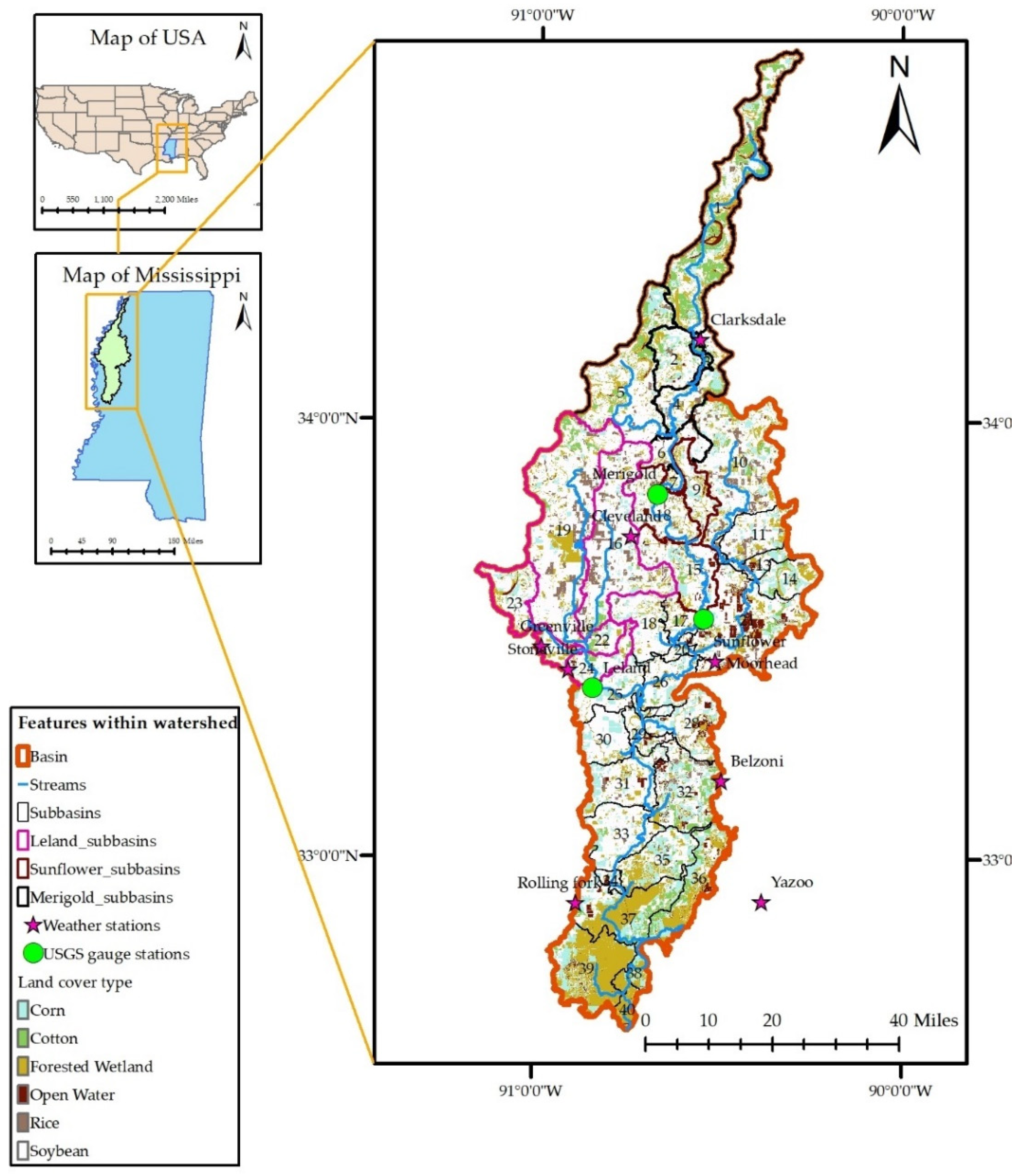
The Big Sunflower River Watershed (BSRW), the study area under consideration, is an agricultural intensive watershed. The Big Sunflower River has been designated as “ephemeral”, which means it is unfit for aquatic life or human consumption and does not support fisheries’ resources [
14]. The United States Environmental Protection Agency (USEPA) has classified Big Sunflower River as impaired under clean water act Section 303 (d) due to high levels of total suspended solids/sediments, nutrients, turbidity, and low dissolved oxygen [
15], which eventually makes its way to Gulf of Mexico. Long-term river water quality can have a significant impact on the environmental characteristics of a bay and coastal water bodies [
16]. Conventional tillage is the most common system for crop production in the Mississippi delta [
17]. Conventional tillage-based agriculture has the disadvantage of increasing soil erosion rates [
18]. Modeling and analysis of data revealed that existing sediment yields in the impaired reaches of BSRW is up to 10.5 metric tons/km
2/day [
19]. NPS pollution of sediments and nutrients is primarily caused by crop cultivation in BSRW, whereas NPS pollution of pathogen is mainly caused by livestock, urbanization, and wildlife [
20]. The change in land use in the Mississippi River Alluvial Plain, where BSRW lies, has altered streamflow conditions. Research conducted by [
21] evaluated changing land use patterns to assess changes in land use, crop yield, and irrigation from 1969 to 2017. According to the study, the amount of irrigated cropland has grown by 45,000 hectares on average across all study area counties and up to twelve folds in one county. Both surface and groundwater are utilized for irrigation, which has altered streamflow. Significant hydrologic changes, such as streamflow depletion and baseflow reduction, have been observed.
Conservation practices, also known as best management practices (BMPs), can help to prevent soil erosion and enhance water quality by lowering the sediments and other pollutants washed away from agricultural fields [
22,
23,
24]. Different BMPs, such as cover crops, buffer strips, tailwater recovery ponds, constructed wetlands, conservation tillage, etc., have been found to reduce runoff and pollutants [
25]. In BSRW, tailwater recovery ponds in agricultural land use have been found to reduce streamflow by 2 to 6%, sediment by 3 to 20%, and increase groundwater storage rate by 0 to 20% depending on the size of the pond [
26]. BMPs are either structural or nonstructural practices [
27]. Structural BMPs are natural or artificial structures built on the field, e.g., grade stabilization structures (GSS) whereas nonstructural BMPs are the practices within the agricultural areas, e.g., contour farming that helps to reduce sediments and other pollutants.
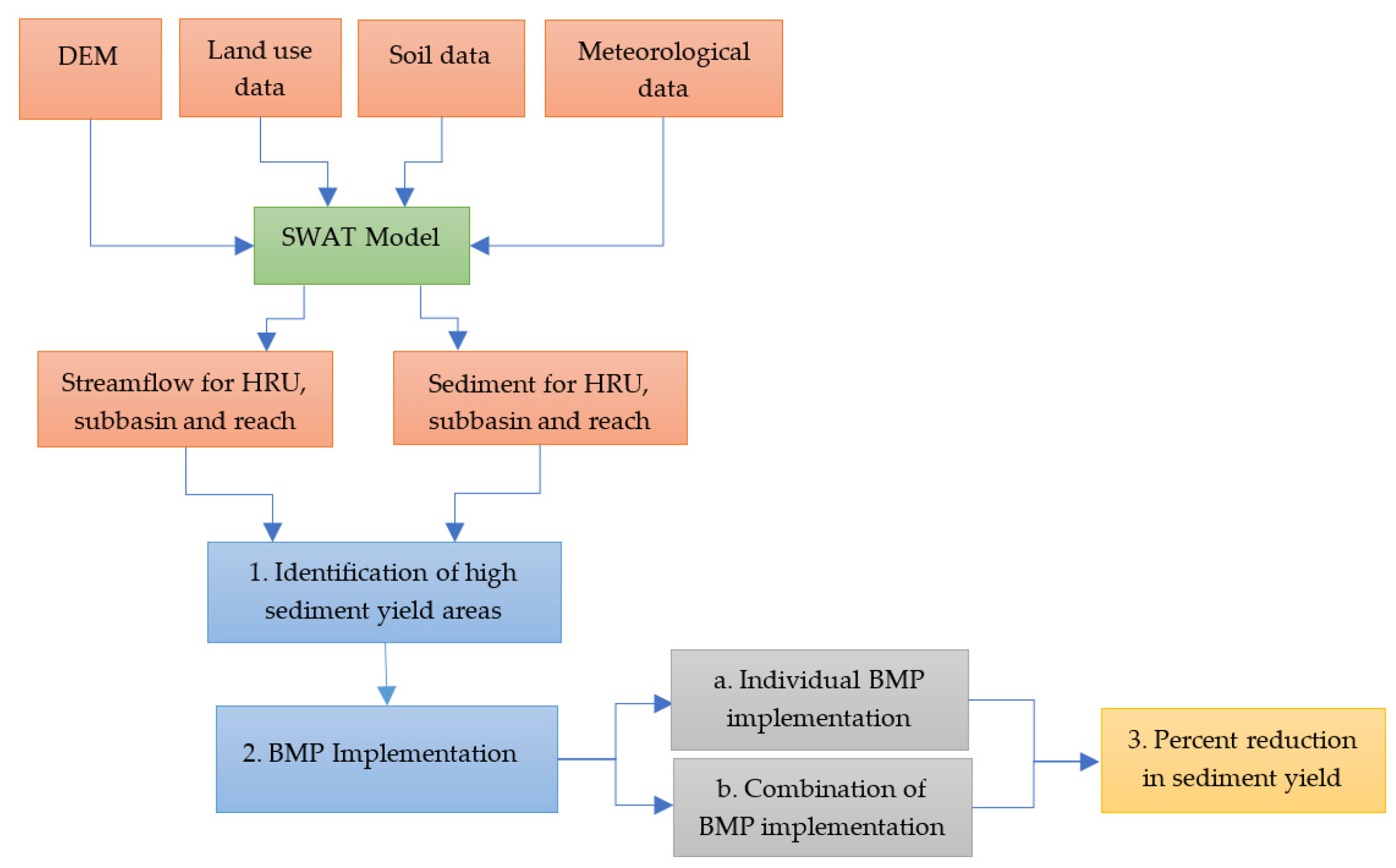
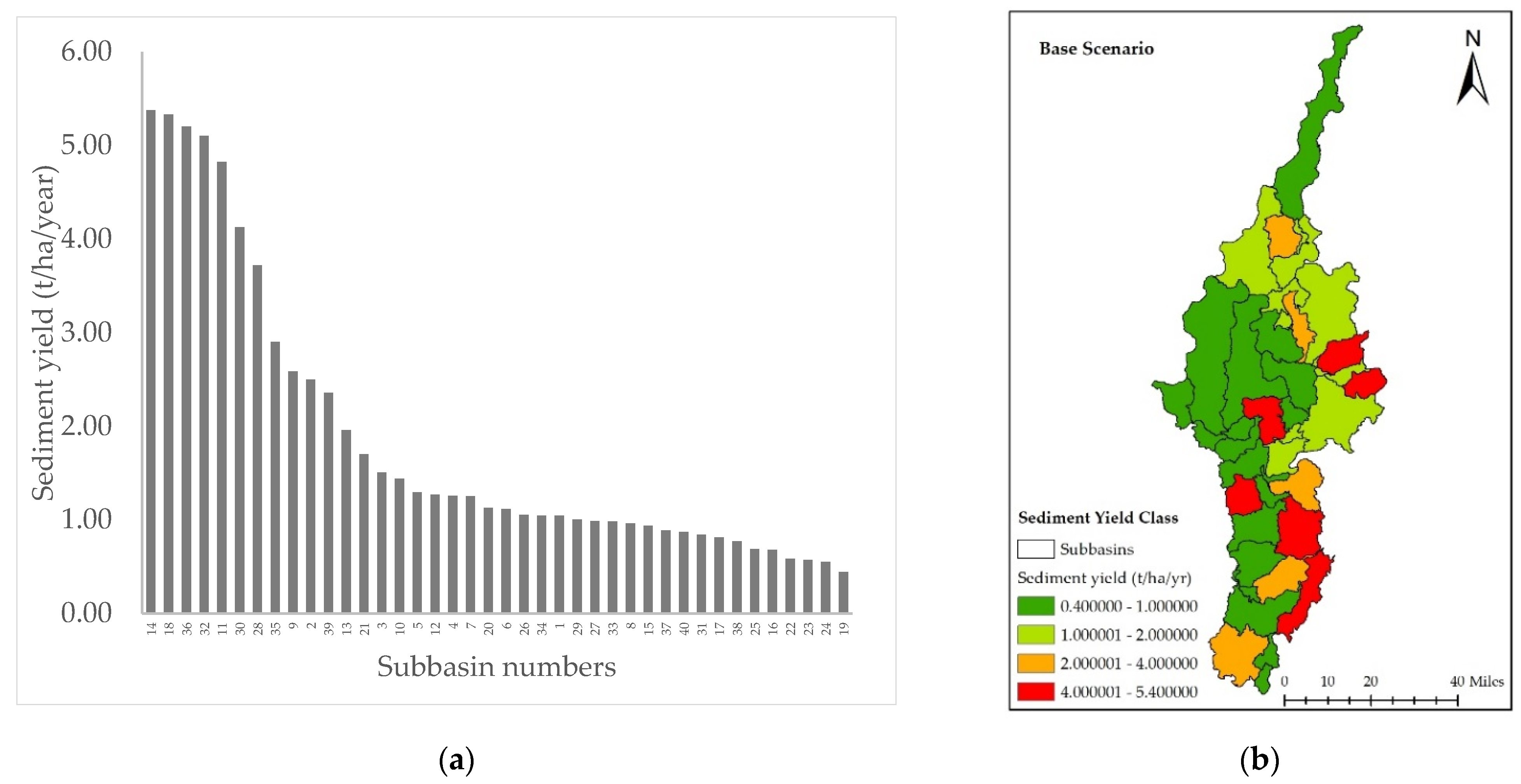
It is unrealistic to expect such management strategies to be implemented throughout a watershed. As a result, high priority areas should be identified in order to save time, money, and resources [
28]. The hydrological models and remote sensing technology are useful in identifying the critical erosion prone areas of a watershed [
29]. Soil and Water Assessment Tool (SWAT) is a hydrological model that could be used to assess the impact of BMPs on non-point source pollution and water supplies at high erosion prone areas within a watershed [
30].
To analyze the influence of BMPs on water quality at the watershed scale, watershed managers depend on computer-based models [
31]. Due to the ability of SWAT to simulate non-point source pollutants such as sediments and nutrients, as well as agricultural operations such as tillage, crop rotation, and so on, at a watershed scale, it has been used for BMP evaluation and watershed management in different parts of the world [
12,
23,
32,
33]. SWAT outperforms other watershed scale models due to its capacity to accommodate tillage practices and site specific dimensions of BMPs [
34]. A study by [
27] presents an optimization technique for determining the best combination of structural BMPs for achieving treatment goals at a watershed scale. Using the SWAT model, [
35] assessed the long-term effect of structural BMPs on sediment and phosphorus loads’ reduction in two Black Creek sub-watersheds. Five BMP scenarios were simulated, including both structural and nonstructural measures using SWAT for environmental and cost benefit evaluation [
33]. The SWAT model was utilized to simulate structural BMPs to demonstrate that watershed subdivision-induced spatial resolution effects have a significant impact on the evaluation of BMPs [
36]. However, in Mississippi’s agriculturally intensive northwestern region, limited studies have looked at the effects of structural BMPs on soil erosion and hydrology. Some nonstructural and structural BMPs were evaluated previously, such as crop rotation, tillage management, tailwater recovery ponds, vegetative filter strips (VFS), etc. [
12,
26,
37]. The evaluation of grassed waterways (GWW) and GSS has not been conducted in the watershed to quantify sediment yields. This study evaluated BMPs such as VFS, GSS, and GWW and their combinations to see if the water quality benefits of combining BMPs are much larger than the benefits of using them separately. The impact assessment of these BMPs can be a novel contribution to the BSRW, which is an agricultural watershed.
The study is based on the hypothesis that the SWAT watershed modeling can help identify the high priority areas with comparatively higher sediment yields, and that simulating BMPs on these areas can provide estimates of potential mitigation. According to the literature review, the SWAT model has been widely used in several studies to assess the effects of BMPs on sediments and NPS pollution in different parts of the world. There is still a need to implement the SWAT model under various climatic and geographic scenarios. The watersheds differ in their hydrological and physical characteristics, so the response to runoff and sediment transport varies as well. Implementing SWAT in various watersheds allows researchers to better understand the complex flow and transport mechanisms that occur under changing environmental conditions. In light of the preceding, this study aimed to fulfill the following objectives: (a) development of a watershed scale model, (b) calibration and validation of SWAT model for simulating flow and sediment load, (c) locating areas with comparatively higher sediment yield using calibrated and validated model (d) evaluation of the impacts of BMPs and their combinations on streamflow and sediment yields at watershed and sub-watershed levels to test the extent to which combining BMPs improves water quality as compared to using them individually.
4. Conclusions
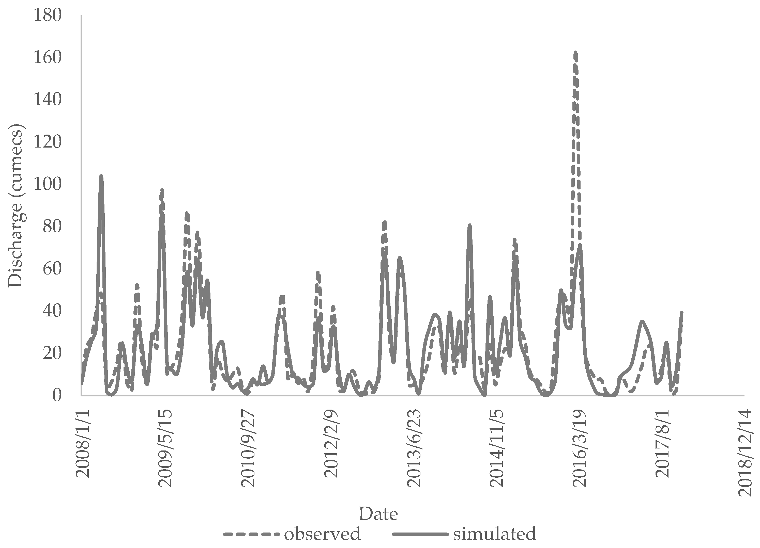
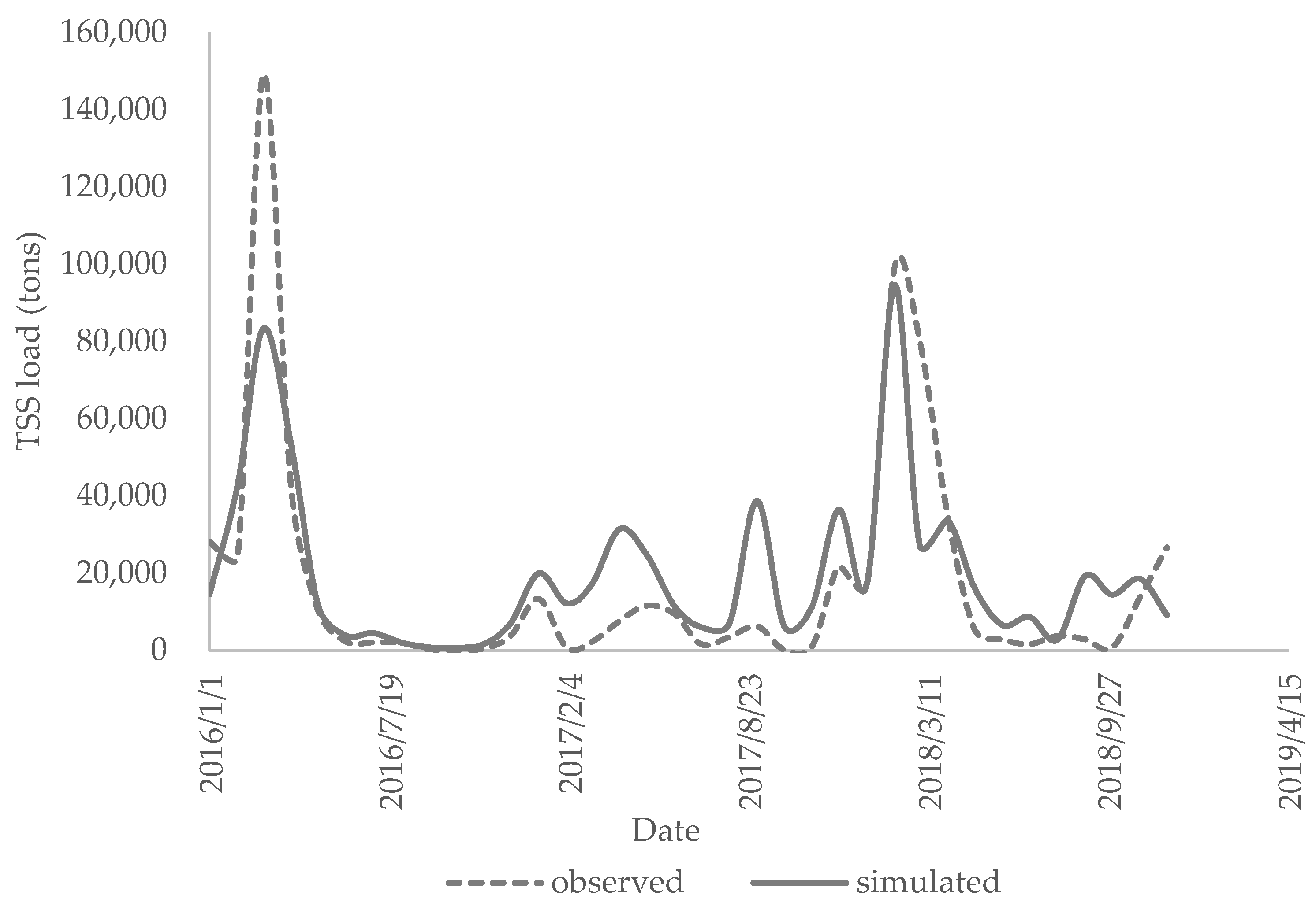
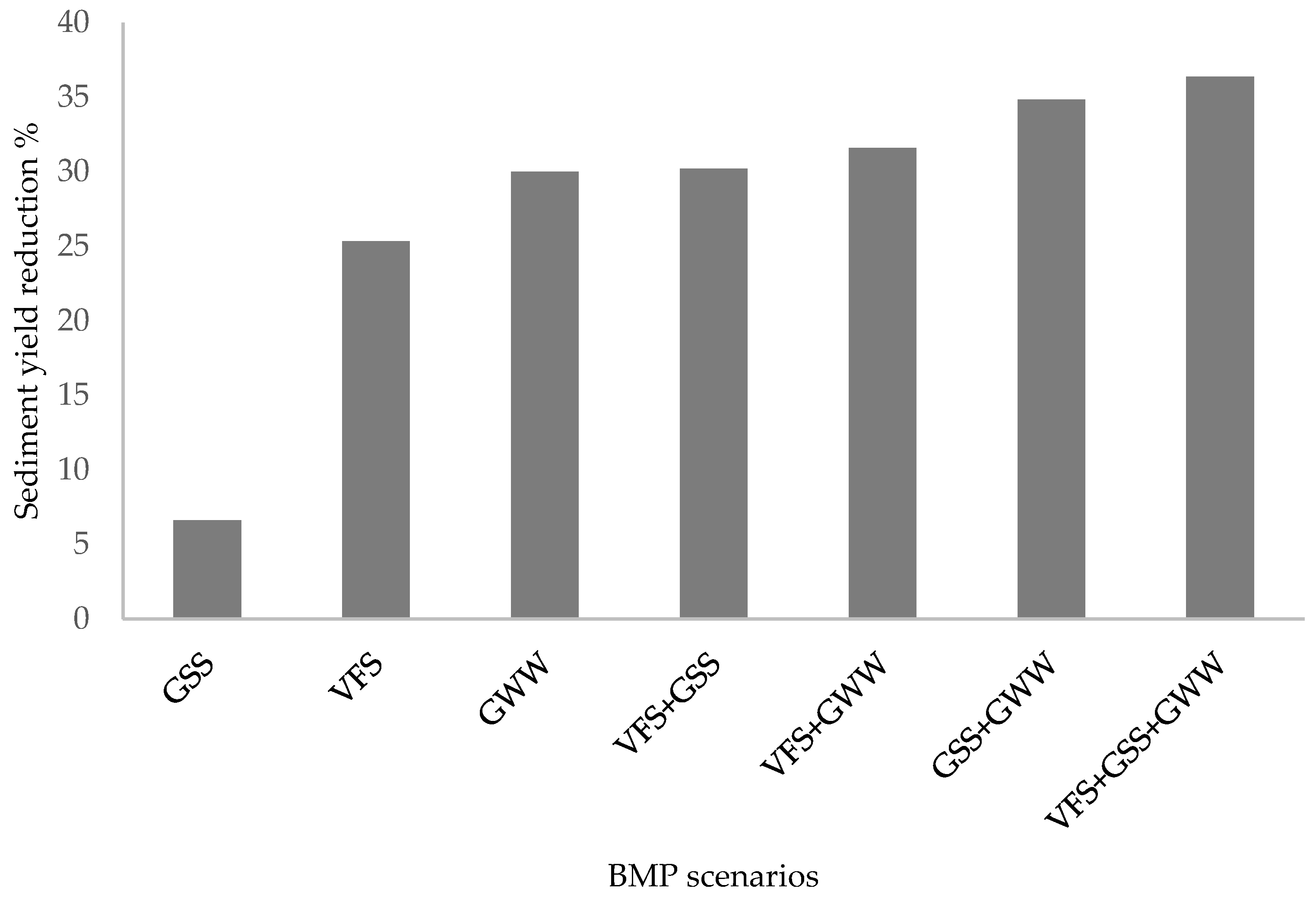
This study was conducted in a watershed in northwestern Mississippi using a calibrated and validated SWAT model to simulate the runoff and sediment yield. The statistical indicators showed acceptable model performance in simulating the runoff and TSS load. LOADEST tool was used to interpolate continuous daily data of TSS load. Seven different structural BMP scenarios, GSS, GWW, VFS, and their combinations were implemented in the high priority areas within the watershed, and their impacts on flow and sediment yield reduction at both watershed and sub-watershed levels were documented.
The outcomes of the simulation revealed that all the selected BMPs had a substantial impact on sediment yield reduction and a 0 to less than 1% reduction in flow. The sediment yield reduction potential of different BMPs scenarios was variable, with the highest reduction in the case of a combination of all three BMPs. In the evaluation of individual BMPs, at both watershed and sub-watershed levels, GWW exhibited the highest sediment yield potential, followed by VFS, which explains their widespread use [
71]. The combination of GSS and GWW had the highest potential for reducing sediment yield when compared to other combinations of two BMPs. According to the results, combining all three BMPs is the most preferable. However, in the event of budget limits, the combination of GSS and GWW could be utilized.
The findings of this study are beneficial to watershed managers as well as the scientific community. Watershed managers and decision-makers can make use of the information to help them choose appropriate BMPs and ensure sustainable watershed management. The findings of this work will aid modelers in successfully performing multisite SWAT calibration and validation using tools such as SWAT CUP and LOADEST.
It is worth noting that this study has not considered the costs, operation, maintenance, and life cycle of the BMPs. The technical efficacy of these approaches may be limited by local constraints such as geographic challenges, farmers’ acceptance, resources availability, economic expenses, and so on. Future studies could help to analyze the uncertainty and fill this gap in the execution of the proposed BMPs at a watershed scale.


