Article

GIS-Based Optimal Siting of Offshore Wind Farms to Support Zero-Emission Ferry Routes

by
Orfeas Karountzos
*,
Stamatina Giannaki
and
Konstantinos Kepaptsoglou
Laboratory of Transportation Engineering, Department of Infrastructure and Rural Development, School of Rural, Surveying and Geoinformatics Engineering, National Technical University of Athens, 157 80 Athens, Greece
*
Author to whom correspondence should be addressed.
J. Mar. Sci. Eng. 2024, 12(9), 1585; https://doi.org/10.3390/jmse12091585
Submission received: 15 August 2024 / Revised: 4 September 2024 / Accepted: 6 September 2024 / Published: 8 September 2024
(This article belongs to the Section Marine Energy)

Abstract

:
To achieve net zero emissions from ships by 2050 and align with the IMO 2023 GHG strategy, the maritime industry must significantly increase zero-emission vessels by 2030. Transitioning to fully electric ferry lines requires enhanced energy supply through renewable energy sources (RES) for complete GHG mitigation and net-zero emissions. This study presents a GIS-based framework for optimally selecting offshore wind farm locations to meet the energy demands of electric ferry operations along coastal routes. The framework involves two stages: designing feasible zero-emission ferry routes between islands or to the mainland and identifying optimal offshore wind farm sites by evaluating technical, spatial, economic, social, and environmental criteria based on national legislation and the academic literature. The aim is to create a flexible framework to support decision making for establishing sustainable electric ferry operations at a regional level, backed by strategically located offshore wind farms. The study applies this framework to the Greek Coastal Shipping Network, focusing on areas with potential for future electrification. The findings can aid policymakers in utilizing spatial decision support systems (SDSS) to enhance efficient transportation and develop sustainable island communities.

1. Introduction

Maritime transport emissions are expected to increase 50–250% by 2050 due to sector expansion [1,2]. In recent years, both the International Maritime Organization (IMO) and other bodies strongly promote fossil fuel phase-out strategies in shipping, exploring mitigation measures such as cleaner fuels, and slow steaming [2,3,4,5,6,7,8], mainly focusing on reducing operational speeds [9,10,11,12,13] to reduce fuel consumption and GHG emissions. Under normal operations and specifically in pre-COVID periods, coastal shipping in the Aegean Sea served around 12 million passengers in 2019 [14], highlighting the network’s importance considering territorial cohesion and economic growth. High seasonality affects the operations of the Greek Coastal Shipping Network (GCSN), particularly during summer when about 45% of annual demand occurs, necessitating fast frequent service to support tourism and supply needs. While high-speed catamarans and other vessels enhance service levels, they in turn deteriorate the environmental footprint in this sensitive ecosystem [15,16].
Historically, as is the case for all insular countries, the GCSN is crucial for the economic growth and connectivity of islands with mainland Greece, ensuring the exchange of products, services, and territorial cohesion. Changes in the regulatory framework, such as the abolition of cabotage rights under Law 2932/2001 and adherence to EU regulations, opened the market to competition, allowing EU-compliant shipowners to operate freely [17]. This legislative shift, coupled with technological advancements, has fostered a more dynamic and interconnected shipping network.
Distinct seasonal traffic patterns in shipping significantly influence financial outcomes, with companies concentrating on more profitable routes during peak periods and reducing operations in quieter quarters, relying on summer revenues for financial sustainability [14]. This is highly important, especially for insular countries such as Greece, with maritime transportation playing a crucial role in supporting the tourism industry, which thrives during the summer months. This operational focus necessitates efficient fleet management, routing, and scheduling to balance profitability with environmental goals [18]. Fleet aging and the need for compliance with new IMO regulations prompt ongoing challenges in maintaining service quality amidst evolving market and regulatory conditions, highlighting the need for fleet renewal to meet future environmental standards [19].
It is clear that the operation of the GCSN, its energy needs, and its overall efficiency are issues that increasingly attract the interest of both researchers and practitioners, seeking solutions to ensure its sustainability, both financially and environmentally. To that end, this study aims to assess whether certain areas of the network can be electrified, with electricity supplied exclusively by renewable energy sources (RES). Such a shift, of course, will not only alter operations, leading to a future restructuring of the network but can potentially ensure the viability of specific routes of the network, in terms of their economic sustainability, while also minimizing GHG emissions, through truly zero-emission routes.

1.1. Electrification in Maritime Transport

There are several conventional strategies that have been applied to mitigate emissions and comply with environmental footprint regulations set by the IMO. However, conventional strategies’ actual effects have been somewhat small, with a maximum overall emission decrease of about 10% to 15% [20,21]. Nevertheless, the potential of renewable energy sources and green technologies has been frequently highlighted, which might greatly improve the industry’s environmental impact [22], especially in the latest years, as the IMO increasingly promotes more sustainable solutions and greener fuels [23], in order to completely restrict fossil marine fuels by 2050.
The idea of electrifying ferries has gained interest in the last few years, especially for limiting the environmental externalities of the maritime sector. Both hybrid–electric and completely electric ferries have already been operating in a number of cases, with Scandinavian countries leading the way in the adoption of regulations that support the switch to electric fleets [24,25]. Still, there are several challenges along the way for ferry electrification. According to Koumentakos [22], issues with cost and performance can make it difficult to carry out such strategies successfully, especially considering operational range constraints. In light of this, a large number of studies have looked into the technology, financial implications, and environmental effects of electrifying ferries. Bellone et al. [26] examined the expansion of public transportation in Vastra Gotaland, Sweden, predicting a significant increase by 2025 with a 70% rise in capacity and a 20–25% reduction in travel times. Reddy et al. [27] emphasized that advances in emission-free technologies could make ferries as a viable option for zero-emission transport, leading to reduced operational costs, improved overall safety, and increased waterborne cargo opportunities.
However, a number of challenges must be addressed in order to fully realize the potential of autonomous ferries. These include passenger accessibility, sensor integration for safety, optimization of energy systems, regulations, policy-related factors, standards, reinforcement of existing power infrastructure, and overall planning. Vicenzutti et al. [28] analyzed the electrification effects on ferries, addressing environmental needs for further protection and emissions mitigation in maritime transport. The study highlighted that stricter pollution regulations necessitate alternative propulsion and energy systems, with electrification as a key strategy alongside the use of green fuels and exhaust treatment equipment. However, it was also noted that not all aspects, such as CO2 emissions from shore-supplied electrical energy, were fully evaluated due to dependencies on local energy sources at ports. Anwar et al. [29] further assessed the electrification of vessels, aiming to create guidelines for the sector’s green transition. Their research identified technical challenges such as the need for extensive charging infrastructure for long voyages and legislative barriers like inadequate energy regulations, while also highlighting the ongoing shift toward green energy solutions in maritime transport to enhance environmental and operational efficiency.
The literature on ferry electrification highlights both technological innovations and specific application contexts, reflecting increased interest in alternative fuels for short-sea shipping as part of broader decarbonization efforts in the shipping industry [30]. Electrification is a key strategy for reducing GHG emissions, especially in areas where these show high concentrations, as emission limitations in such areas could result in higher reductions in total [31]. Considering the existing capabilities of electrified sea transport technologies, it becomes clear that operational range limitations require careful consideration of spatial and geographical factors in the planning of electric ferry services, especially in more complex coastal environments. Therefore, the distinct characteristics of different waterway routes and shipping networks are critical for the effective integration of electrification in the industry. Despite this, a significant gap exists in the literature concerning the planning of operations, considering network topology and spatial characteristics. Consequently, relative studies should focus on specifically addressing the identification of potential areas within a ferry network that could transition to fully electrified solutions while considering topological factors and exploiting relevant spatial data [32].

1.2. Renewable Energy Source Supply

Energy needs for insular countries, such as Greece, are of critical importance, especially during tourist-heavy summer periods, necessitating robust energy strategies (C. Iliopoulou et al., 2018). Fully electrified zero-emission operations primarily require energy from renewable energy sources (RES) to mitigate both operational and production emissions. As a result, interest in RES is rising, particularly as costs of investments and upkeep decline [33].
The electrification of island-connecting routes and the use of 100% RES systems are gaining attention. Even though the environmental benefits of fully zero-emission islands are substantial, the complexity of selecting optimal RES development sites is significant [34]. Spatial decision support systems (SDSS) and GIS technologies have proven beneficial in assisting policymakers, researchers, and practitioners in decision making, especially with the growing interest in offshore RES investments. For instance, Sourianos et al. [35] developed a methodology for optimal offshore wind farm placement using web-based GIS software, addressing the lack of simultaneous site evaluation capabilities in existing software by including environmental, socio-economic, and spatial planning considerations. This approach allows for comparing multiple sites while integrating public participation and spatial considerations into their GIS-based study, enhancing its utility in identifying potential areas for future wind farm installations.
Vagiona and Kamilakis [36] explored a comprehensive methodology for offshore wind farm site evaluation, integrating technical, spatial, economic, social, and environmental criteria using GIS and multi-criteria decision methods. Their findings support sustainable spatial development and policy making, demonstrating the value of spatial analysis and multi-criteria decision making in determining optimal sites in the South Aegean Sea. Taoufik and Fekri [37] assessed Morocco’s offshore wind energy potential using an integrated GIS and Fuzzy Analytic Hierarchy Process (FAHP) methodology, highlighting the economic potential and adaptability of this GIS-based approach for similar regional analyses.
These studies underscore the potential benefits of RES facilities, especially for Greece and the GCSN, particularly in regions like the Aegean Sea with favorable wind conditions and significant sunlight, enhancing offshore wind and photovoltaic outputs. This study aims to contribute to this body of knowledge by assessing the energy supply of electrified routes using RES and specifically, offshore wind farms, providing a methodological framework for evaluating potential zero-emission maritime networks within the GCSN, thus laying the groundwork for future research and policy-making in this vital sector.

1.3. Contribution of the Study

The literature on offshore wind farm siting, utilizing various criteria and GIS software, is extensive. However, these studies have primarily focused on identifying optimal sites for RES infrastructure development, neglecting the specific application of the generated energy. This presents a significant gap in understanding how RES can be integrated into the broader energy needs of island communities and remote locations.
While RES can address various energy requirements, including those of island communities, few studies have explored their integration into sustainable transport systems. Consequently, this study aims to develop a comprehensive spatial decision support system to design fully sustainable net-zero-emission coastal shipping routes. This system will facilitate the transition of island communities and coastal shipping to more sustainable transport modes by electrifying ferry fleets.
The remainder of the paper is structured as follows: the next section presents the study’s methodology and the case study area where this is implemented. Next, the results and discussion for the optimal siting of offshore wind farms to support zero-emission ferry lines in the Aegean Sea are presented and discussed. The paper concludes with the main findings of the study.

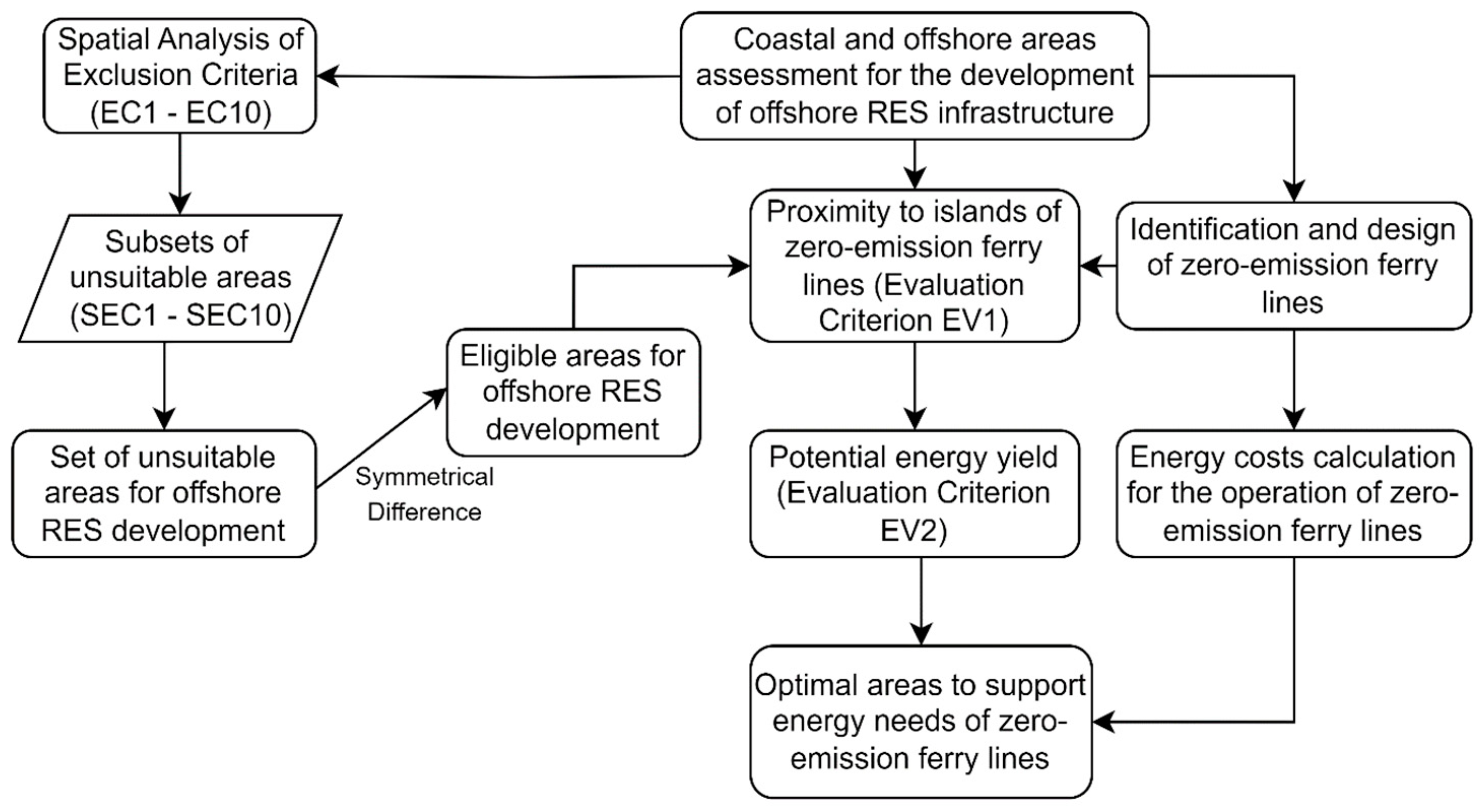
2. Materials and Methods

2.1. Design of Zero-Emission Ferry Lines

To address the issue of designing zero-emission ferry lines, a hub-spoke and cluster-first route-second approach can be implemented. Redesigning a complex network can be data-intensive, especially for passenger networks, where multiple factors are at play and optimal solutions for operators may not align with those for users (i.e., in this case passengers), especially regarding social and environmental standards set by policymakers. A workflow such as the one proposed in a previous study by the authors can be implemented to generate feasible zero-emission ferry lines in any given coastal shipping network or any other passenger shipping one with distances under the feasible electric ferry range capabilities [32,38]. The GIS-based framework utilized for the generation of feasible zero-emission ferry lines is shown in Figure 1, as developed by the author [38].
The above processes are modeled and executed in a GIS environment, specifically ArcGIS Pro 3.0, employing its ModelBuilder capabilities based on available tools [39,40,41,42]. In addition, in order to identify which ports can actually be connected via zero-emission ferry lines, passenger capacity constraints are considered. Considering the need for at least one daily roundtrip with an electric ferry to and from such islands, with a maximum capacity of 180 passengers, low-demand ports can be assumed as those with a weekly demand of at most 1260 passengers. With passenger data obtained from the Hellenic Statistical Authority (ELSTAT), optimal ferry lines generated for all islands of the GCSN can be filtered to only connect such islands between them and from/to a hub-port of higher demand in proximity of the maximum feasible range of an electric ferry, equal to 30 nautical miles for the purposes of this study [38,43,44]. Lastly, in cases where clusters of low-demand islands exist within a sub-network, these can still be connected through a zero-emission ferry line, provided that this originates from a hub port, as generated by the implementation of various spatial analysis techniques, such as Explanatory Spatial Data Analysis (ESDA), Local Indicators of Spatial Association (LISA), or Density-Based Clustering Algorithms. However, as the main scope of this study is not to design and plan such services but to assess the potential of their energy autonomy through the development of RES infrastructure, the design and planning of such services can closely follow the framework for ferry network design under electrification as presented in the authors’ previous studies [32,38], with their results providing the basis for the assessment of net zero-emission ferry operations for this study.

2.2. Offshore Wind Farm Site Selection

In order to assess whether offshore wind farms can be developed in the Aegean to support both island communities’ needs and the operation of a more sustainable coastal ferry system, a comprehensive methodological framework is developed in the form of a spatial decision support system (SDSS). The framework is based on the utilization of available GIS tools and methods and closely follows the workflows that have been extensively discussed in the existing literature [36,45,46,47,48,49]. More specifically, the developed SDSS is based on a bi-level assessment approach, with exclusion (negative) criteria considered during the first level. During the second level of the assessment, different alternatives are evaluated under considerations such as potential energy yield, their distance from ports and islands, and most importantly, their proximity to potential zero-emission ferry lines. The last criterion is the one that differentiates this approach from others in the existing literature, as it proposes a different way for the assessment and development of zero-emission coastal ferry systems by first evaluating the potential of such systems to be self-sufficient and cover their energy needs through RES. Therefore, the proposed SDSS extends research efforts to not be limited to site selection approaches but to additionally assess whether such selections can actually affect existing communities’ well-being, their overall quality of life, and the support of more sustainable transport systems for their connectivity and accessibility needs. An outline of the proposed methodological framework for the development of the SDSS is shown in Figure 2.
Based on the above methodology, the selected criteria that were evaluated to perform the GIS-based Multi-Criteria Site Evaluation (MCSE) are shown in Table 1, considering various previous studies in the existing literature [35,36,46,50,51], while also considering installation parameters for semi-submersible floating offshore wind farms [52].
All of the above criteria are incorporated into GIS geodatabases after the initial data collection. Then, they are processed and analyzed utilizing different spatial analysis methods and tools in order to generate both exclusion maps and assess the potential of different feasible plots. Although there are several existing studies in the literature that have also assessed the feasibility of offshore wind farms and the potential of different areas, mostly considering spatially related criteria, they have been limited in a certain area regarding the evaluation of feasible areas for offshore wind farm siting. In most cases, candidate plots have been evaluated further based on their area coverage in square kilometers, considering that larger areas have more potential compared to smaller ones [35,36]. However, a larger area does not necessarily mean higher energy yield, as there are other parameters in play, such as the minimum allowed distance between different wind turbines in the same wind farm, thus resulting in the fact that area shapes are also important when considering the topological characteristics of the plots under evaluation. In this study, a minimum distance of 12D is taken into consideration, where D equals the rotor diameter of a wind turbine, which in this case is equal to 164 m, considering a typical 8 MW semi-submersible wind turbine.
In order to further assess the potential energy yield of an eligible area, considering the evaluation criterion EV2, a Maximal Covering Location Problem (MCLP) is formulated. Given a polygonal area P and a set of candidate points {p1, p2, …, pn} generated within P, the objective is to select a subset of these points {p1′, p2′, …, pk′} such that
  • The selected points maximize coverage within P;
  • The distance between any two selected points is at least d = 12D.
Considering the above, the objective function of the model is as follows:
maximize   i = 1 n x i
s.t.
x i 0,1 i { 1,2 , , n }
j N i x j 1 i { 1,2 , , n }
where Ni = {jj≠i and distance(pi,pj) < d} is the set of indices of points that are within distance d from point pi.
To solve the above problem, an algorithm is formulated in Python using a PC with a 3.9GHz CPU and 32GB of RAM, following the steps below.
i.
Initial candidate points are generated with the creation of a grid of candidate points within the bounding box of each polygon Pi with the existing spacing d;
ii.
An iterative point selection process is initialized with an empty list of selected points at first;
a.
For each candidate point, a buffer zone is calculated with a radius equal to d;
b.
The number of points within the buffer zone is calculated;
c.
The point with the maximum count of candidate points within its buffer is then selected, ensuring maximal coverage;
d.
Candidate points within distance d of the selected point are then removed from the candidate list;
iii.
The points that remain in the selected list after the iterative process are then generated as the solution to the problem.
As points are generated, denoting wind turbine installation spots inside feasible plots, it is then possible to estimate the potential energy yield of each wind turbine, considering mean wind speeds at their respective points of installation, resulting in the total annual energy yield per plot. To do this, certain assumptions are made considering, as mentioned, a typical 8 MW wind turbine with a rotor diameter of 164 m, as utilized in past research projects such as the WindFloat® Atlantic Wind Farm, which had 3 Vestas® 8.4 MW wind turbines installed with a capacity factor of 34% [52]. Based on the relevant data, generated power from such wind turbines is approximately equal to 1937.50 kW at wind speeds of 6.5–7.49 m/s and 2950 kW at wind speeds of 7.5–8.49 m/s [52].
In order to provide a more realistic scenario, in addition to a capacity factor of 34%, it is also considered that wind farms do not operate all-year-round (i.e., 365 days of operation). Therefore, to generate the annual energy yield, 200 days of operation are considered, with the resulting yearly output in GWh being calculated as follows:
A n n u a l   E n e r g y   Y i e l d   GWh = 24 × W T a × Y d a + W T b × Y d b × C f × O p e r a t i o n a l   D a y s × 10 6
where
WTa and WTb denote the number of wind turbines inside areas of variable wind speeds between 6.5–7.49 m/s and 7.5–8.49 m/s, respectively.
Yda and Ydb are the energy outputs in kW under variable wind speeds between 6.5–7.49 m/s and 7.5–8.49 m/s, respectively, with Yda = 1937.50 kW and Ydb = 2950 kW.
Cf is the capacity factor.
Regarding the above considerations, the immediate and future energy yields can be calculated. Short-term energy yield refers to a more realistic scenario, with a cutoff point of at most 5 wind turbines per feasible plot, whereas long-term energy yield refers to the maximum feasible generated output per plot. Evidently, this distinction is made due to the fact that, while larger plots may show greater potential in terms of energy outputs, as significantly more wind turbines can be installed in them, such a case would not be feasible in terms of the necessary investments. Therefore, energy yield is calculated for both scenarios. However, the short-term scenario, being the more financially sustainable and economically viable choice, is used for evaluation purposes in this study.

3. Results

Through the implementation of the aforementioned methodological framework, promising results are generated for the study area in the Aegean Sea. Specifically, the analysis and processing of the aforementioned criteria led to the final evaluation of 63 feasible plots, as shown in Figure 3. Further filtering the resulting dataset to consider only areas where at least 5 wind turbines could be installed resulted in 23 feasible wind farm plots, with their characteristics shown in Table 2. In addition, Figure 3 also shows the feasible future zero-emission ferry lines generated for the GCSN by the authors’ previous studies [32,38], with several islands where zero-emission ferries can operate.
As the yearly energy yield is calculated, the next step is to assess whether the development of wind farms in the resulting plots can cover the energy needs of potential zero-emission coastal ferry lines, as shown in Figure 3. Table 3 shows the calculated energy needs of such zero-emission ferry lines for two distinct areas of the Aegean: the Cyclades complex and the Dodecanese/Eastern Aegean areas. These zero-emission ferry lines have been the result of previous studies by the authors [32,38], with their energy consumption calculated considering energy consumption per nautical mile traveled and the charging capabilities of one of the largest ferries in operation [43,44].
Considering short-term scenarios of offshore wind farm development, in addition to all-year-round (365 days) operation, with one round-trip per day, daily consumption for the Dodecanese/Eastern Aegean region equals 22.768 MWh or 16.62 GWh yearly. Regarding the Cyclades region, the total daily consumption from zero-emission ferry operations equals 32.96 MWh daily or 12.03 GWh yearly, considering all-year-round operations with one daily round-trip. As a result, both results are compared with the generated yearly electricity output of 15.81 GWh, considering the short-term scenario and the development of only one offshore wind farm on one plot per region. This leads to an excess electricity output of 3.78 GWh in the Cyclades region, in contrast to a deficit of 0.811 GWh per annum in the Dodecanese/Cyclades region. However, this is a deficit that can be balanced in the future, especially considering the potential of plots 109 and 147 in the area. Regarding the Cyclades region, while feasible plots do not show the same potential as the ones in the Dodecanese/Eastern Aegean region, there are significantly more options for offshore wind farm development, especially considering areas such as plot 41.

4. Discussion

The results obtained from this study demonstrate the strong potential of offshore wind energy in the Aegean Sea to support zero-emission ferry operations, particularly within the Greek Coastal Shipping Network (GCSN). The analysis identified 23 feasible offshore wind farm sites, capable of accommodating at least five wind turbines each, with yearly energy yields varying across different plots. This variance underscores the importance of carefully selecting development sites that maximize both technical feasibility and energy output.
In the Cyclades region, the total annual energy consumption for the proposed zero-emission ferry routes was calculated to be approximately 12.03 GWh, while available plots could generate an energy yield of 15.81 GWh under the short-term development scenario, leading to a surplus of 3.78 GWh. These results indicate that offshore wind farms in the Cyclades could not only sustain the energy needs of the ferry lines but also provide excess energy that could be redirected to meet the demands of island communities, promoting energy autonomy.
Conversely, in the Dodecanese/Eastern Aegean region, the estimated energy consumption for zero-emission ferry lines was found to be 16.62 GWh annually. Here, the energy output from the short-term scenario fell slightly short at 15.81 GWh, resulting in a deficit of 0.811 GWh. However, this shortfall is relatively minor and could be mitigated by further developing nearby wind farm sites with higher wind speeds, such as plots 109 and 147, which show substantial long-term potential. Moreover, additional infrastructure investments and the optimization of ferry schedules could bridge this gap, allowing for a fully sustainable energy system in this region as well.
The quantitative findings presented here strongly indicate that offshore wind energy can play a pivotal role in the decarbonization of coastal maritime transport, particularly in regions with favorable wind conditions. The ability to not only meet the energy demands of ferry operations but also generate excess electricity highlights the potential of offshore wind farms to contribute to the broader goal of energy autonomy for insular communities.
Additionally, the findings emphasize the significance of integrating energy production with maritime transport planning. Zero-emission ferry operations require a holistic approach that goes beyond simply adopting electric ferries; it involves designing a fully sustainable energy system. By aligning the development of offshore wind farms with the specific energy needs of ferry routes, this study provides a framework that can be adapted to other regions with similar geographic and logistical characteristics.
Looking forward, there are several areas for further research. First, future studies should explore the potential for integrating energy storage technologies, such as battery systems, to ensure consistent energy availability during periods of low wind. Second, further work is needed to evaluate the financial feasibility of larger-scale wind farm development, particularly in regions with high energy demand. Third, future research should consider the broader environmental and social impacts of wind farm installations, particularly their potential effects on marine ecosystems and local economies. Furthermore, future studies should also further assess whether photovoltaic (PV) solar farms can supplement the total energy supply, especially during optimal PV solar power periods. While these have been assessed in a past study by the authors [32], it is highly suggested that future studies further evaluate such combinations of RES in order to result in an optimal mix of both resources to cover the energy needs of such routes. Lastly, a highly important issue for future studies would be the economic feasibility of wind farm investments, both for initial development and upkeep during operation. Considering the same semi-submersible system of wind turbines as the one of the Wind Float Atlantic [52], where overall the relevant project required a substantial investment of about 120 million euros, it is crucial for future studies to incorporate financial considerations in their studies, resulting in important findings considering the economic assessment of the feasibility of developing and operating such wind farms.
The generated results demonstrate the Aegean’s significant potential in wind resources for the development of RES infrastructure, specifically offshore wind farms. Even with several constraints that could limit the potential of total electricity output, such as a more realistic capacity factor and fewer days of operation considered, results still show that zero-emission ferry operations can be fully supported by the development of offshore wind farms, resulting in truly sustainable net-zero emission ferry operations in the Aegean. In addition, excess electricity output could be exploited to cover the energy needs of island communities that seek to achieve energy autonomy, thus resolving an important issue for insular communities, not just in the case of the GCSN but other insular and Polynesian countries as well.

5. Conclusions

This study presents a comprehensive GIS-based framework for identifying optimal offshore wind farm sites to support zero-emission ferry routes within the Greek Coastal Shipping Network (GCSN). The findings demonstrate that offshore wind energy has substantial potential to meet the energy demands of fully electrified ferry operations, thereby contributing to the decarbonization of the maritime transport sector. The feasibility of these zero-emission ferry lines not only offers a pathway to achieving greenhouse gas (GHG) reduction targets but also provides additional benefits in terms of energy autonomy for insular communities.
Several key conclusions can be drawn from this research.
  • The results confirm that offshore wind farms, even with conservative estimates, are capable of generating sufficient energy to support zero-emission ferry operations in both the Cyclades and Dodecanese/Eastern Aegean regions. In the Cyclades, a surplus of energy could be used to power local communities, reinforcing the notion that renewable energy sources (RES) can drive sustainable development in coastal and island regions. In the Dodecanese, the slight energy deficit can be addressed by leveraging additional nearby wind farm plots, demonstrating the flexibility and scalability of the proposed system;
  • The transition to zero-emission maritime transport requires coordinated policy efforts that promote both the adoption of green technologies and the development of renewable energy infrastructure. Policymakers must consider the role of spatial decision support systems (SDSS) in guiding the sustainable electrification of ferry networks, ensuring that investments in offshore wind farms are aligned with energy needs and environmental objectives. The results of this study underscore the need for a long-term policy framework along with regulatory changes that will encourage RES integration into national and regional transport plans, particularly for maritime and insular regions, thus unlocking the full potential of offshore wind resources;
  • While this study establishes the feasibility of offshore wind-powered zero-emission ferries, there are several areas that require further investigation. Future research should focus on the economic viability of scaling up wind farm developments, particularly in regions where demand may exceed current projections. Additionally, the integration of energy storage systems, such as batteries, could be explored to stabilize energy supply during periods of low wind availability. Finally, more detailed assessments of the environmental and social impacts of offshore wind farms, including their effects on marine biodiversity and local communities, are essential for developing truly sustainable energy solutions.
In conclusion, the findings of this study provide a strong foundation for the continued development of zero-emission ferry networks, supported by renewable offshore energy sources. By aligning energy production with the specific needs of maritime transport, Greece—and similar coastal and island regions—can lead the way in decarbonizing the maritime sector, contributing to both national and international climate goals. The framework presented here can be further refined and adapted to other regions, offering a scalable and sustainable approach to the challenges of transitioning to green maritime transport systems.

Author Contributions

Conceptualization, O.K. and S.G.; Methodology, O.K. and K.K.; Validation, O.K.; Formal analysis, O.K.; Data curation, S.G.; Writing—original draft, O.K.; Writing—review & editing, O.K. and K.K. All authors have read and agreed to the published version of the manuscript.

Funding

This research received no external funding.

Institutional Review Board Statement

The present study does not require relevant ethical approval.

Informed Consent Statement

Not applicable.

Data Availability Statement

The datasets generated and/or analyzed during the current study are available from the corresponding author on reasonable request.

Conflicts of Interest

The authors declare no conflict of interest.

References

  1. Smith, T.W.; Jalkanen, J.P.; Anderson, B.A.; Corbett, J.J.; Faber, J.; Hanayama, S.; O’Keeffe, E.; Parker, S.; Johansson, L.; Aldous, L.; et al. Third IMO GHG Study. Available online: https://wwwcdn.imo.org/localresources/en/OurWork/Environment/Documents/Third%20Greenhouse%20Gas%20Study/GHG3%20Executive%20Summary%20and%20Report.pdf (accessed on 3 August 2024).
  2. Zisi, V.; Psaraftis, H.N.; Zis, T. The Impact of the 2020 Global Sulfur Cap on Maritime CO2 Emissions. Marit. Bus. Rev. 2021, 6, 339–357. [Google Scholar] [CrossRef]
  3. Crist, P. Greenhouse Gas Emissions Reduction Potential from International Shipping. In OECD/ITF Joint Transport Research Centre Discussion Papers; No. 2009/11; OECD Publishing: Paris, France, 2009. [Google Scholar] [CrossRef]
  4. Rehmatulla, N.; Calleya, J.; Smith, T. The Implementation of Technical Energy Efficiency and CO2 Emission Reduction Measures in Shipping. Ocean Eng. 2017, 139, 184–197. [Google Scholar] [CrossRef]
  5. Eide, M.S.; Endresen, Ø.; Skjong, R.; Longva, T.; Alvik, S. Cost-Effectiveness Assessment of CO2 Reducing Measures in Shipping. Marit. Policy Manag. 2009, 36, 367–384. [Google Scholar] [CrossRef]
  6. Ju, Y.; Hargreaves, C.A. The Impact of Shipping CO2 Emissions from Marine Traffic in Western Singapore Straits during COVID-19. Sci. Total Environ. 2021, 789, 148063. [Google Scholar] [CrossRef]
  7. Franc, P.; Sutto, L. Impact Analysis on Shipping Lines and European Ports of a Cap- and-Trade System on CO 2 Emissions in Maritime Transport. Marit. Policy Manag. 2014, 41, 61–78. [Google Scholar] [CrossRef]
  8. Xing, H.; Spence, S.; Chen, H. A Comprehensive Review on Countermeasures for CO2 Emissions from Ships. Renew. Sustain. Energy Rev. 2020, 134, 110222. [Google Scholar] [CrossRef]
  9. Cariou, P. Is Slow Steaming a Sustainable Means of Reducing CO2 Emissions from Container Shipping? Transp. Res. Part D Transp. Environ. 2011, 16, 260–264. [Google Scholar] [CrossRef]
  10. Degiuli, N.; Martić, I.; Farkas, A.; Gospić, I. The Impact of Slow Steaming on Reducing CO2 Emissions in the Mediterranean Sea. Energy Rep. 2021, 7, 8131–8141. [Google Scholar] [CrossRef]
  11. Woo, J.-K.; Moon, D.S.-H. The Effects of Slow Steaming on the Environmental Performance in Liner Shipping. Marit. Policy Manag. 2014, 41, 176–191. [Google Scholar] [CrossRef]
  12. Pastra, A.; Zachariadis, P.; Alifragkis, A. The Role of Slow Steaming in Shipping and Methods of CO2 Reduction. In Sustainability in the Maritime Domain: Towards Ocean Governance and Beyond; Springer International Publishing: Cham, Switzerland, 2021; pp. 337–352. [Google Scholar]
  13. Yin, J.; Fan, L.; Yang, Z.; Li, K.X. Slow Steaming of Liner Trade: Its Economic and Environmental Impacts. Marit. Policy Manag. 2014, 41, 149–158. [Google Scholar] [CrossRef]
  14. Hellenic Statistical Authority—EL.STAT Economy and Indices Statistics Section. Available online: http://www.statistics.gr (accessed on 7 May 2022).
  15. Bigano, A.; Sheehan, P. Assessing the Risk of Oil Spills in the Mediterranean: The Case of the Route from the Black Sea to Italy (February 2006). FEEM Working Paper No. 32.2006. Available online: https://ssrn.com/abstract=886715 (accessed on 4 August 2024).
  16. Iliopoulou, C.; Kepaptsoglou, K.; Schinas, O. Energy Supply Security for the Aegean Islands: A Routing Model with Risk and Environmental Considerations. Energy Policy 2018, 113, 608–620. [Google Scholar] [CrossRef]
  17. Schinas, O.D. Exploring the Possibility for Hub-and-Spoke Services in the Greek Coastal System. Int. J. Ocean Syst. Manag. 2009, 1, 119. [Google Scholar] [CrossRef]
  18. Christiansen, M.; Fagerholt, K.; Nygreen, B.; Ronen, D. Chapter 4 Maritime Transportation. Handb. Oper. Res. Manag. Sci. 2007, 14, 189–284. [Google Scholar] [CrossRef]
  19. XRTC Business Consultants 19th Annual Study on Greek Shipping 2020: “Responsibility and Realism, the Prerequisites for Tackling the New Reality”. 2020. Available online: https://xrtc.gr/industry-reports/ (accessed on 4 August 2024).
  20. Ammar, N.R. Energy- and Cost-Efficiency Analysis of Greenhouse Gas Emission Reduction Using Slow Steaming of Ships: Case Study RO-RO Cargo Vessel. Ships Offshore Struct. 2018, 13, 868–876. [Google Scholar] [CrossRef]
  21. Cullinane, K.; Cullinane, S. Atmospheric Emissions from Shipping: The Need for Regulation and Approaches to Compliance. Transp. Rev. 2013, 33, 377–401. [Google Scholar] [CrossRef]
  22. Koumentakos, A. Developments in Electric and Green Marine Ships. Appl. Syst. Innov. 2019, 2, 34. [Google Scholar] [CrossRef]
  23. Raucci, C.; Smith, T.; Rehmatulla, N.; Palmer, K.; Balani, S.; Pogson, G. Zero-Emission Vessels 2030: How Do We Get There? Low Carbon Pathways 2050 series; Lloyd’s Register Group Limited; UMAS: London, UK, 2017. [Google Scholar]
  24. Sæther, S.R.; Moe, E. A Green Maritime Shift: Lessons from the Electrification of Ferries in Norway. Energy Res Soc Sci 2021, 81, 102282. [Google Scholar] [CrossRef]
  25. Tarkowski, M. Towards a More Sustainable Transport Future—The Cases of Ferry Shipping Electrification in Denmark, Netherland, Norway and Sweden. In Innovations and Traditions for Sustainable Development; Springer: Cham, Switzerland, 2021; pp. 177–191. [Google Scholar]
  26. Bellone, M.; Lundh, M.; Wahde, M.; MacKinnon, S. Electrification and Automation in Maritime Applications: Employing AI Techniques for Energy Optimization and Efficiency. IEEE Electrif. Mag. 2019, 7, 22–31. [Google Scholar] [CrossRef]
  27. Reddy, N.P.; Zadeh, M.K.; Thieme, C.A.; Skjetne, R.; Sorensen, A.J.; Aanondsen, S.A.; Breivik, M.; Eide, E. Zero-Emission Autonomous Ferries for Urban Water Transport: Cheaper, Cleaner Alternative to Bridges and Manned Vessels. IEEE Electrif. Mag. 2019, 7, 32–45. [Google Scholar] [CrossRef]
  28. Vicenzutti, A.; Mauro, F.; Bucci, V.; Bosich, D.; Sulligoi, G.; Furlan, S.; Brigati, L. Environmental and Operative Impact of the Electrification of a Double-Ended Ferry. In Proceedings of the 2020 Fifteenth International Conference on Ecological Vehicles and Renewable Energies (EVER), Monte-Carlo, Monaco, 10–12 September 2020; IEEE: New York, NY, USA, 2020; pp. 1–6. [Google Scholar]
  29. Anwar, S.; Zia, M.Y.I.; Rashid, M.; de Rubens, G.Z.; Enevoldsen, P. Towards Ferry Electrification in the Maritime Sector. Energies 2020, 13, 6506. [Google Scholar] [CrossRef]
  30. Zis, T.P.V.; Psaraftis, H.N.; Tillig, F.; Ringsberg, J.W. Decarbonizing Maritime Transport: A Ro-Pax Case Study. Res. Transp. Bus. Manag. 2020, 37, 100565. [Google Scholar] [CrossRef]
  31. Karountzos, O.; Kagkelis, G.; Iliopoulou, C.; Kepaptsoglou, K. GIS-Based Analysis of the Spatial Distribution of CO2 Emissions and Slow Steaming Effectiveness in Coastal Shipping. Air Qual. Atmos. Health 2024, 17, 661–680. [Google Scholar] [CrossRef]
  32. Karountzos, O.; Kagkelis, G.; Kepaptsoglou, K. A Decision Support GIS Framework for Establishing Zero-Emission Maritime Networks: The Case of the Greek Coastal Shipping Network. J. Geovisualization Spat. Anal. 2023, 7, 16. [Google Scholar] [CrossRef]
  33. Luderer, G.; Madeddu, S.; Merfort, L.; Ueckerdt, F.; Pehl, M.; Pietzcker, R.; Rottoli, M.; Schreyer, F.; Bauer, N.; Baumstark, L.; et al. Impact of Declining Renewable Energy Costs on Electrification in Low-Emission Scenarios. Nat. Energy 2021, 7, 32–42. [Google Scholar] [CrossRef]
  34. Pfeifer, A.; Prebeg, P.; Duić, N. Challenges and Opportunities of Zero Emission Shipping in Smart Islands: A Study of Zero Emission Ferry Lines. eTransportation 2020, 3, 100048. [Google Scholar] [CrossRef]
  35. Sourianos, E.; Kyriakou, K.; Hatiris, G.A. GIS-based spatial decision support system for the optimum siting of offshore windfarms. Eur. Water 2017, 58, 337–343. [Google Scholar]
  36. Taoufik, M.; Fekri, A. GIS-Based Multi-Criteria Analysis of Offshore Wind Farm Development in Morocco. Energy Convers. Manag. X 2021, 11, 100103. [Google Scholar] [CrossRef]
  37. Karountzos, X.O. GIS-Assisted Optimal Design of Maritime Transport Systems; National Technical University of Athens (NTUA), School of Rural, Surveying and Geoinformatics Engineering: Athens, Greece, 2023. [Google Scholar]
  38. ESRI Optimal Path as Line (Spatial Analyst). Available online: https://pro.arcgis.com/en/pro-app/latest/tool-reference/spatial-analyst/optimal-path-as-line.htm (accessed on 4 August 2024).
  39. ESRI Iterate Feature Selection. Available online: https://desktop.arcgis.com/en/arcmap/latest/tools/modelbuilder-toolbox/iterate-feature-selection.htm (accessed on 4 August 2024).
  40. ESRI Euclidean Distance (Spatial Analyst). Available online: https://pro.arcgis.com/en/pro-app/latest/tool-reference/spatial-analyst/euclidean-distance.htm (accessed on 4 August 2024).
  41. ESRI Understanding Euclidean Distance Analysis. Available online: https://pro.arcgis.com/en/pro-app/latest/tool-reference/spatial-analyst/understanding-euclidean-distance-analysis.htm (accessed on 4 August 2024).
  42. E-Ferry Project The E-Ferry Ellen Information Package. Final Validation and Evaluation Report. 2020. Available online: https://ec.europa.eu/research/participants/documents/downloadPublic?documentIds=080166e5cfbf7f6f&appId=PPGMS (accessed on 4 August 2024).
  43. Gagatsi, E.; Estrup, T.; Halatsis, A. Exploring the Potentials of Electrical Waterborne Transport in Europe: The E-Ferry Concept. Transp. Res. Procedia 2016, 14, 1571–1580. [Google Scholar] [CrossRef]
  44. Van Haaren, R.; Fthenakis, V. GIS-Based Wind Farm Site Selection Using Spatial Multi-Criteria Analysis (SMCA): Evaluating the Case for New York State. Renew. Sustain. Energy Rev. 2011, 15, 3332–3340. [Google Scholar] [CrossRef]
  45. Vanegas-Cantarero, M.M.; Pennock, S.; Bloise-Thomaz, T.; Jeffrey, H.; Dickson, M.J. Beyond LCOE: A Multi-Criteria Evaluation Framework for Offshore Renewable Energy Projects. Renew. Sustain. Energy Rev. 2022, 161, 112307. [Google Scholar] [CrossRef]
  46. Mukhamediev, R.I.; Mustakayev, R.; Yakunin, K.; Kiseleva, S.; Gopejenko, V. Multi-Criteria Spatial Decision Making Supportsystem for Renewable Energy Development in Kazakhstan. IEEE Access 2019, 7, 122275–122288. [Google Scholar] [CrossRef]
  47. Hanssen, F.; May, R.; van Dijk, J.; Rød, J.K. Spatial Multi-Criteria Decision Analysis Tool Suite for Consensus-Based Siting of Renewable Energy Structures. J. Environ. Assess. Policy Manag. 2018, 20, 1840003. [Google Scholar] [CrossRef]
  48. Doorga, J.R.S.; Hall, J.W.; Eyre, N. Geospatial Multi-Criteria Analysis for Identifying Optimum Wind and Solar Sites in Africa: Towards Effective Power Sector Decarbonization. Renew. Sustain. Energy Rev. 2022, 158, 112107. [Google Scholar] [CrossRef]
  49. Satir, M.; Murphy, F.; McDonnell, K. Feasibility Study of an Offshore Wind Farm in the Aegean Sea, Turkey. Renew. Sustain. Energy Rev. 2018, 81, 2552–2562. [Google Scholar] [CrossRef]
  50. Bagiorgas, H.S.; Mihalakou, G.; Rehman, S.; Al-Hadhrami, L.M. Offshore Wind Speed and Wind Power Characteristics for Ten Locations in Aegean and Ionian Seas. J. Earth Syst. Sci. 2012, 121, 975–987. [Google Scholar] [CrossRef]
  51. Windplus, S.A. WindFloat Atlantic: World’s First Semi-Submersible Floating Offshore Wind Farm. Available online: https://www.windfloat-atlantic.com/ (accessed on 4 August 2024).
  52. Matysik, S.; Bauer, L. Wind Turbine Models. Available online: https://en.wind-turbine-models.com/turbines/318-vestas-v164-8.0 (accessed on 4 August 2024).
Figure 1. GIS-based model for the identification of optimal paths of electric ferry lines via obstacle-based routing.
Jmse 12 01585 g001
Figure 2. GIS-based workflow for the assessment of coastal and offshore RES infrastructure development to support zero-emission ferry lines.
Jmse 12 01585 g002
Figure 3. Feasible plots for future offshore wind farm development and zero-emission ferry lines.
Jmse 12 01585 g003
Table 1. Evaluation criteria for GIS-based MCSE.
TypeNoDescriptionUnsuitable Areas
Exclusion CriteriaEC1Water depth<50 m and >175 m.
EC2Proximity to marine protected areas<2000 m
EC3Proximity to shipping routes<1 nautical mile
EC4Military areas (Restricted Hellenic Airspace)All areas
EC5Proximity to wildlife sanctuaries<2000 m
EC6Wind Speed (10m)<6.5 m/s
EC7Proximity to underwater cables<1000 m
EC8Proximity to coastline<5000 m
EC9Distance from existing ports/coastline>25,000 m
EC10Proximity to coastal water bodies<1000 m
TypeNo.DescriptionFactor
Evaluation CriteriaEV1Proximity to coastline of islands with hub-ports of future zero-emission ferry lines Technical/Economic
(<10 km)
EV2Short-term and long-term energy yieldTechnical/Economic
Table 2. Yearly energy yield (GWh) per feasible plot for offshore wind farm development (min. 5 wind turbines).
Plot IDWind Speed (m/s)Yearly Energy Yield (GWh)
Short-Term Scenario
(max. 5 Wind Turbines)
Yearly Energy Yield (GWh)—Long-Term Scenario
(Maximum Installations)
Plot Location
6.5–7.497.5–8.49
Wind Turbines
277 15.8122.13East of Euboea
2812 15.8137.94East of Euboea
338 15.8125.30Southwest of Naxos
399 15.8128.46Southeast of Syros
4123617.01101.61East of Mykonos
429 15.8128.46Between Syros-Tinos-Mykonos
5420 15.8163.24Northwest of Chios
57213 15.81673.51South of Lemnos
58201316.41650.01East of Lemnos
667 15.8122.13Northeast of Naxos
677 15.8122.13North of Naxos
8211 15.8134.78West of Lesbos
8321 15.8166.40West of Lesbos
87 943.3343.33West of Lesbos
1019 15.8128.46North of Astypalaia
10715 15.8147.43Northeast of Donousa
10920 15.8163.24West of Patmos
11540 15.81126.48Southeast of Chios
1196 15.8118.97West of Lesbos
12815 15.8147.43Southwest of Rhodes
1375 15.8115.81West of Kos
14721 15.8166.40North of Patmos
14925 15.8179.05North of Agathonisi
Table 3. Calculated energy needs of zero-emission ferry lines.
DesignationPortDistance from Previous (n.miles)Remaining Energy for Next Leg (kWh)Charging Time at Port (mins)Consumption per Round Trip (MWh)
HubPatmos03800 8.16
Spoke 1Leipsoi11352015
Spoke 2Arkoi14300015
Spoke 3Agathonisi2692072
HubIkaria03800 1.60
SpokeFournoi10300020
HubKos03800 9.648
Spoke 1Nisyros23276020
Spoke 2 Tilos19.2202420
Spoke 3Chalki18.157680.6
HubPatmos03800 3.36
Spoke 2Leros21212042
HubNaxos03800 13.248
Spoke 1Iraklia18276010
Spoke 2Schinousa2.2298410
Spoke 3Ano Koufonisi7.1281610
Spoke 4Donousa14.1168852.8
HubMilos03800 4.16
SpokeKimolos13300026
HubIos03800 5.792
Spoke 1Sikinos7.134325
Spoke 2 Folegandros11275231.2
HubMykonos03800 1.76
SpokeDelos5.5336011
HubSantorini03800 8.00
SpokeAnaphi25180050
Disclaimer/Publisher’s Note: The statements, opinions and data contained in all publications are solely those of the individual author(s) and contributor(s) and not of MDPI and/or the editor(s). MDPI and/or the editor(s) disclaim responsibility for any injury to people or property resulting from any ideas, methods, instructions or products referred to in the content.

