1. Introduction
In Peru, the Fisheries and Aquaculture (FandA) sector account for 2% Gross Domestic Product (GDP) [
1]. In particular, aquaculture production has grown at an average annual rate of 12%, from 28,400 metric tons (MT) in 2006 to just over 100,000 MT in 2017, being rainbow trout (
Oncorhynchus mykiss), prawns (
Litopenaeus vannamei), fan shell (
Argopecten purpuratus) and tilapia (different varieties), species which represent 97% of the total volume harvested [
2]. In 2017, trout accounted for 54.63% (54, 878.43 MT) of Peruvian aquaculture production, 88.6% of which remained in the national market, consolidating a growth of 339.1% over the last ten years [
3]. However, Peruvian aquaculture still has some limitations (technological, commercial, logistics organization, access to credit, technical-professional capacity, network of service providers, and easily accessible goods) that have not allowed its expansion compared to other countries of the region such as Chile, Ecuador, Brazil, and Mexico [
2,
4]. In addition, one of the biggest challenges for the sustainable development of aquaculture is the common use of water, land and other resources with alternative uses such as fisheries, livestock, agriculture and tourism, among others [
5].
To enable sustainable and competitive aquaculture, under the Ecosystem Approach to Aquaculture (EAA) [
6,
7], this activity must be spatially planned, including zoning, selection of suitable sites and design of aquaculture management areas [
5,
8]. In order to minimize as much as possible, the common problems arising from the lack of spatial and administrative planning [
5,
9] are: (i) fish diseases; (ii) environmental problems (eutrophication, loss of ecosystem services and biodiversity, etc.); (iii) production problems (lower growth and biomass, oxygen and microalgae overconsumption, poor product standardization, etc.); (iv) social conflicts; (v) post-harvest problems; (vi) financial risk, and; (vii) lack of resilience to climate variations and other external threats and disasters.
In this sense, remote sensing (RS), Geographic Information Systems (GIS) and the technique of Multi-criteria Evaluation (MCE) integration are recognized as a decision support system which integrates spatially referenced data in a space-referenced environment decision-making problem, which often include a large set of viable alternatives [
5,
10]. An MCE technique that has been used to describe, explain, and predict suitable sites under criteria of interest is the Analytical Hierarchy Process (AHP) [
10]. The AHP reduces subjectivity in decision-making by creating a series of filters (hierarchies) of selection and at the same time, it allows the choice between complex alternatives [
11].
The tools RS, GIS, and MCE have allowed studies of land suitability evaluation for inland aquaculture (lentics and lotics). The entire territory of Africa [
12], Latin America [
13], Uruguay [
14], Colombia [
15] and other regions of smaller geographical extent [
10,
16,
17,
18,
19,
20,
21,
22,
23,
24,
25,
26] has been evaluated. In Peru, no similar studies have been reported, and aquaculture in land-ponds becomes more important since insurance permits for inland aquaculture production are easily taken by smallholder farmers, who belong to the Limited Resource Aquaculture (AREL; 62.3%) and Micro and Small Business (AMYPE; 37.5%) [
27]. In summary, they guarantee the livelihoods of just over 1% of the Peruvian population [
2], contribute to food security (increased consumption of animal protein and improvement of nutritional levels), and help to alleviate poverty [
10]. However, the establishment and expansion of small-scale aquaculture have been performed without regard to the suitability of the site in terms of land, water, supplies, socio-economics, and other resources available for aquaculture development [
19].
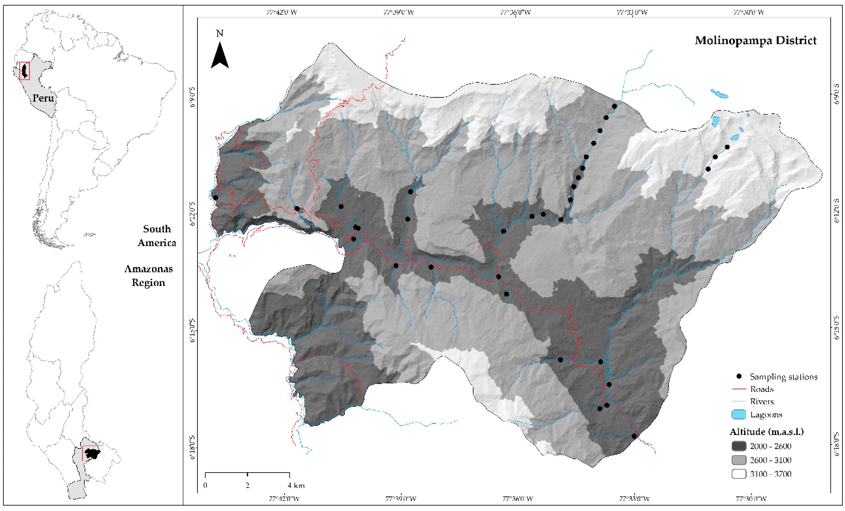
Given the importance of aquaculture and the limitations of land suitability assessments for fish farming, this study has likewise integrated RS, GIS, and AHP with the aim of modeling land suitability for sustainable rainbow trout aquaculture in the Molinopampa district in Peru. Consequently, (a) key criteria (socio-economic, environmental and physicochemical of water sources) for the proper development of fish activity were identified and mapped; (b) the importance of criteria and sub-criteria was hierarchized and weighted by peer-to-peer comparison matrices, and; (c) potential sites were determined for the development of the activity. Finally, it seeks to provide tools for the decision-making process in the allocation of land for aquaculture in the district, furthermore, to present a methodological framework in inland aquaculture, which may be replicated, with the necessary complements, for the entire FandA sector in Peru.
4. Discussion
Based on the multi-study review, FAO [
5,
59,
60,
61] and other authors [
62,
63,
64] highlight the importance of integrating RS, GIS, and MCE as a competent tool to assist in strategic decision-making for the sustainable development of aquaculture. In fact, FAO commissioned and published the first technical documents on the subject [
61] in 1991 [
65] and 1996 [
66], and most recently in 2007 [
60], 2010 [
59], 2013 [
61], and 2018 [
5]. However, many countries with prominent aquaculture are not yet handling spatial analyses to address problems systematically and synoptically, and use GIS capabilities primarily as tools to generate map viewers [
59], such as the case of Catastro’s Aquaculture in Peru [
27]. On the contrary, spatial methods and modern technology demonstrate that GIS capabilities, in integration with RS and MCE, go beyond management and visualization [
59]. These capacities should be used for the zoning and selection of suitable sites for aquaculture development at the national level, as Uruguay [
14], Colombia [
15] and other countries outside South America [
9,
67] have done.
The key advantages of MCE techniques are that they are well established for aquaculture zoning, they can combine multiple criteria (many more than those used in this study; [
19,
20,
55]), and may develop models under different hierarchies, priorities, and scenarios [
8]. However, the main problem in the analysis of land suitability for aquaculture in ponds dug in the soil, and in general for any activity, lies in the lack of spatial data of the criteria [
16]. In Peru, and specifically in the region of Amazonas, these computing resources are scarce, even more so when it comes to specific studies of biological, environmental, and social criteria at detailed local scales. In view of this, it has been proposed to complement MCE techniques with Species Distribution Models (SDM) [
8], such as Mahalanobis Typicity and MaxEnt [
68]. Despite this being stated, no such approach was applied, because it depends on the georeferenced locations of the fish farms, and even though SDM such as MaxEnt has an extremely small sample size tolerance [
69], it was considered inappropriate to use only the five farms, as it could affect the performance of the model. For further studies, the additional confidence that a combined approach to MCE and SDM would bring would be of vital importance for the aquaculture sector, as sustainable development depends on the planning and management decisions associated with the selection [
8].
This study differs from the only two studies found to assess the land suitability for rainbow trout aquaculture [
17,
18], in the inclusion of a greater number of criteria used, as well as the integration of an MCE (AHP) technique to rank and weight the importance of them. In contrast, it differs from other GIS and MCE-based studies for inland aquaculture in lotic water sources [
20,
23,
24,
26], because it complements the spatial suitability of the land in raster model, with an assessment of the suitability of resource quality [
20,
23,
24,
26], due to the fact that it complements the spatial suitability of the land in raster model with an assessment of the suitability of the quality of the water resource in a vector model. In the latter, the pixel by pixel raster weighted overlay was replaced by field calculator operations in the sample station point vector (SS) attribute table, which contained initial values, reclassified suitability values, and weights of the importance of each sub-criterion.
For the development of aquaculture in Molinopampa, the most important criteria are economic (44.57%), followed by environmental (43.31%), and social (12.12%). According to Lobato et al. [
10], Nayak et al. [
20] and Hadipour et al. [
70], the criterion containing the sub-criterion of distance to water sources is the most important. In Molinopampa, it is the second most important (environmental criterion), since it is a considerably favored area in water resources, with a high drainage density (0.703 km/km
2). This environmental criterion also contains the slope sub-criterion, and contrary to Rodrigues et al. [
16], for whom the slope was the most important factor, in this study it holds second place. In addition to this, and after a long aquaculture experience in Amazonas, the Research Institute of the Peruvian Amazon (IIAP) indicates that the wide availability of water and the existence of terraces (inter-Andean valleys in Molinopampa) are favorable aspects for the construction and operation of fish culture ponds in the region [
71].
As stated by Rodrigues et al. [
16], soil texture, specifically clay content, is also an important factor, however, in this study, it is of little importance (12.88%) because the ponds built for planting in Molinopampa are concrete. As determined by other studies, it is important to keep in mind because in very permeable soils the loss of water by filtration and infiltration could increase the water demand as well as pumping systems [
72].
When it comes to the local reality of Molinopampa, the most decisive criterion was economic. Within this, the most important sub-criteria were the distance to the road network (53.49%) and to the markets (30.65%). The National Fisheries Development Fund of Peru (FONDEPES) recommends that the body of water selected for the development of rainbow trout farming must have vehicular access roads, which allow the fluidity of the arrival of production supplies and the output of the product towards the established markets, taking into account that the rainbow trout is highly perishable [
36]. The expert group considered these sub-criteria to be the most important since Molinopampa lacks good road infrastructure, and the most prominent market (City of Chachapoyas), is an hour away, resulting in a weakness for this activity.
Of the physicochemical sub-criteria, the temperature was the most important (38.33%) for the suitability of water quality, followed by pH (27.27%), and finally dissolved oxygen (21.59%). In fact, FAO [
37] indicates that water temperature is very important because it regulates the growth of rainbow trout, as they do not have their own capacity to regulate their body temperature. If the temperature is very low, the growth is slow, while at higher temperatures, the growth is faster. Although not specifically for rainbow trout, Nayak et al. [
20] found that temperature is the most important criterion among nine physicochemical water criteria evaluated by AHP.
Finally, the climate, the wide availability of land and the plenteousness of water, coupled with the improvement of the connection with national and international markets through roads, as well as the growing markets for aquaculture, are comparative advantages of the region. These can become investment opportunities to develop aquaculture, not only as an activity aimed at meeting local market demand but also with possibilities for competitiveness in the internal and external markets, contributing to the development of region [
71].
5. Conclusions
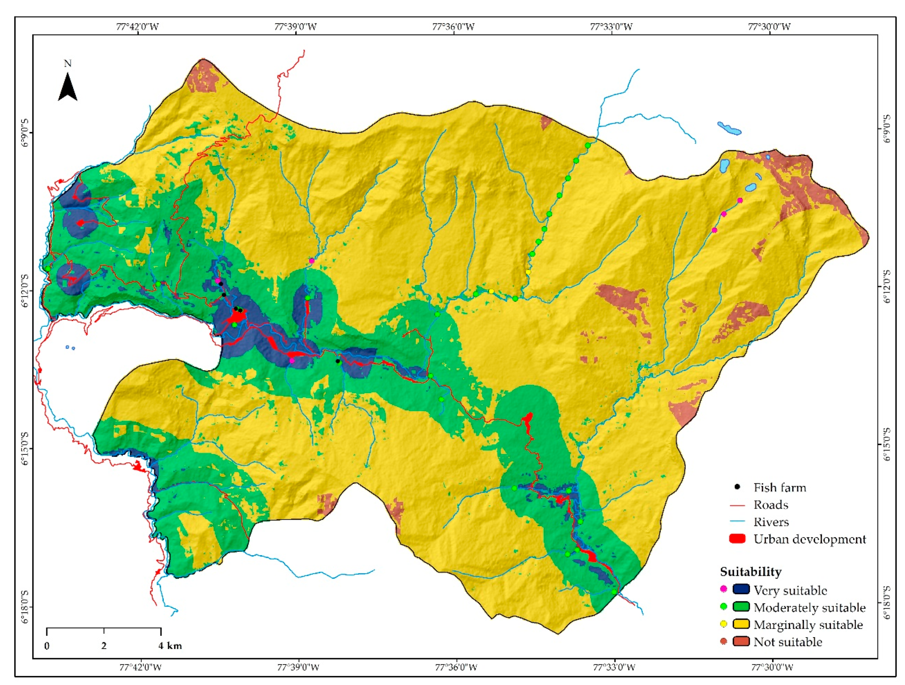
The ten key sub-criteria were identified and mapped to determine the spatial suitability of rainbow trout aquaculture. For Molinopampa, from highest to lowest importance, the results are as follows: the economic sub-criteria (distance to roads, distance to markets, distance to inputs) with 44.57%, followed by the environmental sub-criteria (land cover/land use, land slope, clay content of soil, pH of soil, distance to rivers) with 43.31% and finally, the social sub-criteria (distance to populations and protected areas) with 12.12%. In addition, five key sub-criteria were identified and mapped to determine the suitability of water quality, of which temperature is the most important (38.33%), followed by pH (27.27%), and dissolved oxygen (21.59%). Alkalinity (6.97%) and hardness (5.83%) are the least important.
The 4.26% (14.51 km2) of the Molinopampa area proved “very suitable” for aquaculture. Areas “moderately suitable” (23.03%) and “marginally suitable” (69.73%) accounted for 92.76% of the district’s total area. “Not suitable” areas or those identified as restricted and unclassified, accounted for 2.98% (10.16 km2) of the total study area. By overlaying the water quality suitability model with the spatial suitability model, it was demonstrated that two SS and nine SS are “very suitable” and “moderately suitable”, respectively, which coincide with “very suitable” lands for aquaculture. These are the most suitable and recommended areas for the rainbow trout farming in the district. The results show that there is a potential to increase aquaculture production, as is the government’s policy/strategy.
In Peru, no references to these types of studies have been found. Therefore, a methodological framework is presented for inland aquaculture, which may be replicated, with the necessary complements, for the entire Fisheries and Aquaculture (FandA) sector in Peru. The implementation of this methodology for zoning and selecting suitable areas will contribute to the more effective planning of investments and efforts by both the public and private sectors.

 ,
, 


