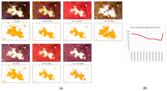
Journal Description
Environmental Sciences Proceedings
is an open access journal dedicated to publishing findings resulting from conferences, workshops, and similar events, in all areas of environmental sciences. The conference organizers and proceedings editors are responsible for managing the peer-review process and selecting papers for conference proceedings.
Latest Articles
Statement of Peer Review
Environ. Sci. Proc. 2023, 26(1), 213; https://doi.org/10.3390/environsciproc2023026213 - 25 Mar 2024
Abstract
In submitting conference proceedings to Environment Sciences Proceedings, the volume editors of the proceedings certify to the publisher that all papers published in this volume have been subjected to peer review administered by the volume editors [...]
Full article
(This article belongs to the Proceedings of 16th International Conference on Meteorology, Climatology and Atmospheric Physics—COMECAP 2023)
Open AccessProceeding Paper
Towards Modeling of the Landscape Evolution of Los Naranjos Archaeological Site, Honduras
by
Nohemy Lizeth Rivera Gutiérrez
Environ. Sci. Proc. 2023, 28(1), 32; https://doi.org/10.3390/environsciproc2023028032 - 15 Mar 2024
Abstract
Los Naranjos is an archaeological site inhabited since approximately 800 BC. The objective is to analyze the landscape of this site to understand the territorial, social, and cultural dynamics, along with its natural environment, since pre-Hispanic times. The methodology involves a documentary review
[...] Read more.
Los Naranjos is an archaeological site inhabited since approximately 800 BC. The objective is to analyze the landscape of this site to understand the territorial, social, and cultural dynamics, along with its natural environment, since pre-Hispanic times. The methodology involves a documentary review of investigations, and a search for mappings and reconstructions of previous studies, historical sources, and fieldwork. Preliminary results include a review of existing sources for model generation.
Full article
(This article belongs to the Proceedings of IV Conference on Geomatics Engineering)
►▼
Show Figures
Figure 1
Open AccessProceeding Paper
Evaluation of Water Vapor-Weighted Mean Temperature Models in GNSS Station ACOR
by
Raquel Perdiguer-López, José Luis Berné Valero and Natalia Garrido-Villen
Environ. Sci. Proc. 2023, 28(1), 31; https://doi.org/10.3390/environsciproc2023028031 - 7 Mar 2024
Abstract
The delay of GNSS signals in the neutral atmosphere allow the determination of atmospheric water vapor. The conversion factor of the delay in the water vapor uses the water vapor-weighted mean temperature, Tm, which is a crucial parameter to improve the
[...] Read more.
The delay of GNSS signals in the neutral atmosphere allow the determination of atmospheric water vapor. The conversion factor of the delay in the water vapor uses the water vapor-weighted mean temperature, Tm, which is a crucial parameter to improve the quality of conversion. This study analyzed two different types of models: linear models such as Bevis, Mendes and Ortiz de Galisteo, and empirical models such as GPT2w, GPT3 and GWMT_D. The performance of the models was analyzed using the models as the source of Tm to obtain the precipitable water vapor (PWV), which was compared to a reference set of PWV obtained from a matched radiosonde site. The results show a better performance of the linear models, with the Bevis model achieving the best performance.
Full article
(This article belongs to the Proceedings of IV Conference on Geomatics Engineering)
Open AccessEditorial
Statement of Peer Review
by
María Belén Benito Oterino, José Fernández Torres, Rosa María García Blanco, Jorge Miguel Gaspar Escribano, Miguel Ángel Manso Callejo and Antonio Vázquez Hoehne
Environ. Sci. Proc. 2023, 28(1), 30; https://doi.org/10.3390/environsciproc2023028030 - 6 Mar 2024
Abstract
In submitting conference proceedings to Environment Sciences Proceedings, the volume editors of these proceedings certify to the publisher that all papers published in this volume have been subjected to peer review administered by the volume editors [...]
Full article
(This article belongs to the Proceedings of IV Conference on Geomatics Engineering)
Open AccessProceeding Paper
Detection of Methane Point Sources with High-Resolution Satellites
by
Itziar Irakulis-Loitxate, Javier Roger, Javier Gorroño, Adriana Valverde and Luis Guanter
Environ. Sci. Proc. 2023, 28(1), 29; https://doi.org/10.3390/environsciproc2023028029 - 26 Feb 2024
Abstract
Methane is the second most important anthropogenic greenhouse gas, whose emissions need to be mitigated to curb global warming. There is a large uncertainty about its point source, but thanks to a new generation of high-spatial-resolution satellites, this situation is changing drastically, revealing
[...] Read more.
Methane is the second most important anthropogenic greenhouse gas, whose emissions need to be mitigated to curb global warming. There is a large uncertainty about its point source, but thanks to a new generation of high-spatial-resolution satellites, this situation is changing drastically, revealing thousands of emission point sources worldwide. In this paper, several hotspot areas are mapped, looking for methane emission point sources with different types of high-resolution satellites. Our results demonstrate the potential of satellite remote sensing to reveal methane emission point sources in different scenarios.
Full article
(This article belongs to the Proceedings of IV Conference on Geomatics Engineering)
►▼
Show Figures
Figure 1
Open AccessProceeding Paper
Preliminary Results of Satellite-Derived Nearshore Bathymetry
by
Ausiàs Roch-Talens, Josep Eliseu Pardo-Pascual and Jaime Almonacid-Caballer
Environ. Sci. Proc. 2023, 28(1), 28; https://doi.org/10.3390/environsciproc2023028028 - 15 Feb 2024
Abstract
This article presents the preliminary results of a study on satellite-derived bathymetry. The purpose of this research is to explore the use of remote sensing and optical imagery for mapping the depth of coastal waters. This study uses empirical models to estimate the
[...] Read more.
This article presents the preliminary results of a study on satellite-derived bathymetry. The purpose of this research is to explore the use of remote sensing and optical imagery for mapping the depth of coastal waters. This study uses empirical models to estimate the water depth based on the optical properties of the water column. To carry this out, it employs atmospheric correction algorithms to remove the influence of atmospheric scattering and absorption on the optical signals. The authors then apply the empirical models to the corrected imagery to obtain the bathymetric maps. The study shows promising results (RMSE ranging between 0.49 and 0.96m using the Lyzenga methodology), with the estimated depths generally consistent with the available ground-truth data. However, the accuracy of the estimated depths varies depending on the water conditions, such as the presence of waves and bottom type. The authors conclude that satellite-derived bathymetry has great potential for coastal applications, such as environmental monitoring and coastal management.
Full article
(This article belongs to the Proceedings of IV Conference on Geomatics Engineering)
►▼
Show Figures
Figure 1
Open AccessProceeding Paper
Tool to Generate Deforestation and Illegal Mining Alerts with Remote Sensing
by
Martha Patricia Valbuena Gaona, Cindy Carolina Ferrucho Parra, María Angélica Prieto Arenas and Germán Alberto Muñoz Bravo
Environ. Sci. Proc. 2023, 28(1), 27; https://doi.org/10.3390/environsciproc2023028027 - 23 Jan 2024
Abstract
The Colombian environmental policies in the 2022–2026 Development Plan align with international guidelines such as the Escazú Agreement, the Rio Declaration, and the Sustainable Development Goals. In concordance with these ongoing efforts, a specialized tool has been developed to effectively identify potential cases
[...] Read more.
The Colombian environmental policies in the 2022–2026 Development Plan align with international guidelines such as the Escazú Agreement, the Rio Declaration, and the Sustainable Development Goals. In concordance with these ongoing efforts, a specialized tool has been developed to effectively identify potential cases of deforestation and illegal mining linked to forest cover loss and the presence of mercury-contaminated water bodies using planet imagery. The workflow used the ArcGIS Pro Task module, with geo-processes integrated into the Python library, arcpy, and fundamental concepts of object-based image analysis (OBIA) and pixel-based analysis. A methodology known as tip and cue was also implemented to detect illegal mining zones. The tool provides efficient means to study environmental crimes and prevent ecosystem damages.
Full article
(This article belongs to the Proceedings of IV Conference on Geomatics Engineering)
►▼
Show Figures
Figure 1
Open AccessProceeding Paper
Analysis of Seismo-Ionospheric Irregularities Using the Available PRNs vTEC from the Closest Epicentral cGPS Stations for Large Earthquakes
by
Karan Nayak, Charbeth López Urias, Rosendo Romero Andrade, Gopal Sharma and Manuel Edwiges Trejo Soto
Environ. Sci. Proc. 2023, 27(1), 24; https://doi.org/10.3390/ecas2023-15144 - 17 Jan 2024
Abstract
The occurrence of earthquakes, which can strike suddenly without any warning, has always posed a potential threat to humanity. However, researchers worldwide have been diligently studying the mechanisms and patterns of these events in order to develop warning systems and improve detection methods.
[...] Read more.
The occurrence of earthquakes, which can strike suddenly without any warning, has always posed a potential threat to humanity. However, researchers worldwide have been diligently studying the mechanisms and patterns of these events in order to develop warning systems and improve detection methods. One of the most reliable indicators for predicting large earthquakes has been the examination of electron availability in the ionosphere. This study focuses on analyzing the behavior of the Total Electron Content (TEC) in the ionosphere during the 30-day period leading up to the three most devastating earthquakes of the past decade. Specifically, the data were examined from the cGPS stations closest to the epicenters: MERS for the Turkey earthquake with 7.8 Mw on 6 February 2023, CHLM for the Nepal earthquake with 7.8 Mw on 25 April 2015, and MIZU for the Japan earthquake with 9.1 Mw on 11 March 2011. Notable positive and negative anomalies were observed for each earthquake, and the vertical Total Electron Content (vTEC) for each PRN (pseudo-random number) was plotted to determine the specific time of the TEC anomaly. The spatial distribution of vTEC for the anomalous specific time revealed that the anomalies were in close proximity to the earthquake epicenters, particularly within denser fault zones.
Full article
(This article belongs to the Proceedings of The 6th International Electronic Conference on Atmospheric Sciences)
►▼
Show Figures
Figure 1
Open AccessProceeding Paper
Tracking the Evolution of Biodeterioration and Physico-Chemical Alterations Using Microphotogrammetric Techniques in the Altamira Cave
by
Vicente Bayarri and Alfredo Prada
Environ. Sci. Proc. 2023, 28(1), 26; https://doi.org/10.3390/environsciproc2023028026 - 16 Jan 2024
Abstract
Caves are open ecosystems with natural microbiota, and they are generally stable if environmental conditions are stable. Some have rock art, which is generally characterized as fragile, especially when the equilibrium conditions of the hypogeum are changed. This article shows how high-resolution microphotogrammetry,
[...] Read more.
Caves are open ecosystems with natural microbiota, and they are generally stable if environmental conditions are stable. Some have rock art, which is generally characterized as fragile, especially when the equilibrium conditions of the hypogeum are changed. This article shows how high-resolution microphotogrammetry, supported by other geomatic techniques, allows the objective and quantifiable control of the alterations suffered by the pigment and its variation over time regarding earlier campaigns. This method, applied periodically, makes it possible to prevent and/or detect possible alterations at an early stage and improve the conditions of the conservation of the cave.
Full article
(This article belongs to the Proceedings of IV Conference on Geomatics Engineering)
►▼
Show Figures
Figure 1
Open AccessProceeding Paper
Comparative Study of Algorithms for Obtaining AOD Using High Spatial Resolution Satellite Imagery
by
María Joaquina Porres, Edgar Lorenzo-Sáez, Javier Solá and Eloína Coll
Environ. Sci. Proc. 2023, 28(1), 25; https://doi.org/10.3390/environsciproc2023028025 - 16 Jan 2024
Abstract
Air pollution control and air quality monitoring are global priority, which also applies to local scales. Ground-based monitoring stations provide high quality values, but their number and cost make them insufficient for use at certain scales and for air monitoring in urban areas.
[...] Read more.
Air pollution control and air quality monitoring are global priority, which also applies to local scales. Ground-based monitoring stations provide high quality values, but their number and cost make them insufficient for use at certain scales and for air monitoring in urban areas. Satellite imagery provides indicators directly related to air quality. Aerosol optical thickness (AOD), used in atmospheric corrections of images, can be used as an indicator of air quality. This product is present in images obtained by satellites of medium spatial resolution, so it is necessary to develop methodologies to obtain it at higher resolution. This work aims to compare methodologies for obtaining AOD and its use in high spatial resolution satellites.
Full article
(This article belongs to the Proceedings of IV Conference on Geomatics Engineering)
Open AccessProceeding Paper
A Space–Air–Earth–Water Sensor Network Used to Determine the Impact of Overexploitation of Water Resources (Ecuador)
by
Ángel Morales Sánchez, Serafín López-Cuervo and Juan F. Prieto
Environ. Sci. Proc. 2023, 28(1), 24; https://doi.org/10.3390/environsciproc2023028024 - 16 Jan 2024
Abstract
This study analyzes repercussions for the morphology, talweg, riverbanks and surrounding structures of several aquatic systems transformed by multipurpose reservoirs located within the Ecuadorian territory of South America. For this purpose, several geomatics techniques were used simultaneously, minimizing the temporal error in the
[...] Read more.
This study analyzes repercussions for the morphology, talweg, riverbanks and surrounding structures of several aquatic systems transformed by multipurpose reservoirs located within the Ecuadorian territory of South America. For this purpose, several geomatics techniques were used simultaneously, minimizing the temporal error in the reservoir water level in order to measure the impact of partial or total emptying operations on these reservoirs. High precision geodetic networks were designed to synchronously use geospatial data-capturing equipment, namely UASs/drones with INS/GNSS systems, LiDAR sensors, RGB optical sensors, USVs/aquatic drones equipped with GNSS systems, and single-beam sensors. Photogrammetric, LiDAR and underwater results were contrasted with topographic techniques used in the monitoring and control of structures. Environmental changes in the surroundings, soil movements due to sedimentary and erosive effects, and possible displacements in existing structures were analyzed.
Full article
(This article belongs to the Proceedings of IV Conference on Geomatics Engineering)
►▼
Show Figures
Figure 1
Open AccessProceeding Paper
Creating a Comprehensive Landslides Inventory Using Remote Sensing Techniques and Open Access Data
by
Constantinos Nefros, Constantinos Loupasakis, Stavroula Alatza and Charalampos Kontoes
Environ. Sci. Proc. 2024, 29(1), 60; https://doi.org/10.3390/ECRS2023-15849 - 15 Jan 2024
Abstract
►▼
Show Figures
Landslides are natural disasters with a high socio-economic impact on human societies due to the considerable number of fatalities and the destruction of infrastructure that they cause. A comprehensive landslides inventory is vital for reducing this impact as it can be used in
[...] Read more.
Landslides are natural disasters with a high socio-economic impact on human societies due to the considerable number of fatalities and the destruction of infrastructure that they cause. A comprehensive landslides inventory is vital for reducing this impact as it can be used in landslides susceptibility studies for the identification of the subregions of an area that are most prone to landslides for the evaluation of the landslide precipitation activation thresholds, and subsequently for the determination of the most suitable precautionary measures. Nowadays, remote sensing techniques are widely used by scientists for creating landslide inventories as they can be rapidly applied to identify landslides along with their spatial characteristics. Nevertheless, besides these characteristics, a comprehensive inventory must also include the time of their activation and the factors that led to their activation. These elements can be quite difficult to specify, especially in areas where official landslide data do not exist, such as in countries that do not have a published national landslides inventory. The objective of this research study is to provide a framework for the creation of a comprehensive landslides inventory by combining open access or publicly available data with remote sensing data and techniques. The Chania regional unit in the western part of Crete Island, Greece, was selected as the study area. Our study presents how a complete landslides inventory, consisting of 236 landslides, was established based on differential interferometric synthetic aperture radar (DInSAR) techniques and open access or publicly available data. This framework can significantly contribute to scientific research on landslide susceptibility in countries that lack a comprehensive landslides inventory. Moreover, it highlights the potential of remote sensing techniques and open access data in improving our understanding of landslide activation mechanisms.
Full article
Figure 1
Open AccessProceeding Paper
Studying Correlation between Precipitation and NDVI/MODIS for Time Series (2012–2022) in Arid Region in Syria
by
Rukea Al-hasn
Environ. Sci. Proc. 2024, 29(1), 58; https://doi.org/10.3390/ECRS2023-16704 - 15 Jan 2024
Abstract
►▼
Show Figures
Vegetation degradation is correlated with drought. The more drought intensifies, the more degraded vegetation increases. Therefore, this study aimed to assess the correlation between rainfall and changes in the Normalized Difference Vegetation Index (NDVI) under arid and semi-arid conditions in Syria. This study
[...] Read more.
Vegetation degradation is correlated with drought. The more drought intensifies, the more degraded vegetation increases. Therefore, this study aimed to assess the correlation between rainfall and changes in the Normalized Difference Vegetation Index (NDVI) under arid and semi-arid conditions in Syria. This study was carried out using annual rainfall data for 2012–2022, obtained from the Agricultural cloud seeding Project, to determine the average rainfall in the study area and to link it to the NDVI of MODIS image data processed using the Google Earth Engine (GEE) for April of each year for the same time series. The results showed that the lowest NDVI value (0.098) was in 2016, representing the driest year during the studied series, while the highest NDVI value (0.24) was in 2019, which coincided with the highest rainfall rate of 206.67 mm, thus representing the least arid year during the same series. It also found a strong correlation (R = 0.7) between the overall average rainfall and the overall NDVI values of the studied time series. This study shows that changes in the NDVI are associated with changes in rainfall, indicating that they can be used to estimate and study drought as a simple method derived from satellite data in isolation from ground data.
Full article
Figure 1
Open AccessProceeding Paper
Impact of Land Use and Land Cover Change on Agricultural Production in District Bahawalnagar, Pakistan
by
Aamir Raza, Muhammad Adnan Shahid, Muhammad Safdar, Muhammad Zaman, Rehan Mehmood Sabir, Hafsa Muzammal and Mian Muhammad Ahmed
Environ. Sci. Proc. 2024, 29(1), 46; https://doi.org/10.3390/ECRS2023-16644 - 15 Jan 2024
Abstract
►▼
Show Figures
Land use and land cover (LULC) change is a major driver of environmental change in District Bahawalnagar, Punjab. LULC change can lead to changes in soil quality, water availability, and climate, all of which can affect crop yields. LULC change can also lead
[...] Read more.
Land use and land cover (LULC) change is a major driver of environmental change in District Bahawalnagar, Punjab. LULC change can lead to changes in soil quality, water availability, and climate, all of which can affect crop yields. LULC change can also lead to the loss of agricultural land, forest land, water bodies, and an increment in urban land that causes climate change and affects the agricultural sector. The study area showed that in the last thirty years, the population increased, built-up land increased, and agricultural land dropped by 30%. The present status of knowledge is reviewed in this paper on the impact of LULC on agricultural production in District Bahawalnagar. The conversion of agricultural land to urban development in District Bahawalnagar has led to a decline in crop yields of an average of 10%. The production of wheat and rice, the two major crops grown in District Bahawalnagar, is influenced by LULC changes. This study also found that the loss of agricultural land has resulted in an increase in soil salinity, which has further reduced crop yields. The detrimental effects of LULC change on agricultural output in District Bahawalnagar can be mitigated by adopting sustainable land management practices. These practices include reforestation, conservation agriculture, and water conservation. The government of Pakistan can also play a role in mitigating the negative impacts of LULC change on agricultural production by developing and implementing land use plans that protect agricultural land from conversion to other uses. More research is required to fully comprehend the effects of LULC and develop effective management strategies. However, LULC is a major challenge that must be addressed if we are to ensure food security in the future.
Full article
Figure 1
Open AccessProceeding Paper
Performance of Assisted-Global Navigation Satellite System from Network Mobile to Precise Positioning on Smartphones
by
Mónica Zabala Haro, Ángel Martín, Ana Anquela and María Jesús Jiménez
Environ. Sci. Proc. 2023, 28(1), 23; https://doi.org/10.3390/environsciproc2023028023 - 15 Jan 2024
Abstract
Indoor navigation is the most challenging environment regarding precise positioning service for a smartphone’s physical quality limitations and interferences for high buildings, trees and multipath fading in the GNSS signal received. A GPS by itself cannot offer a solution; the A-GNSS from a
[...] Read more.
Indoor navigation is the most challenging environment regarding precise positioning service for a smartphone’s physical quality limitations and interferences for high buildings, trees and multipath fading in the GNSS signal received. A GPS by itself cannot offer a solution; the A-GNSS from a network mobile provided through telecommunication infrastructure provides information that is useful to counteract these issues. A smartphone has full connectivity to the mobile network 24/7 and has access to the GNSS database when required, and the assisted information is sent over an Internet Protocol (IP) and processed by the GNSS chip, increasing the accuracy, TTFF, and availability of data even in harsh environments. The outdoor, light indoor, and urban canyon scenarios are experienced when driving in some places in the city, and they are recorded with Geo++ and processed with RTKlib using a single frequency in a standalone and multi-constellation double-frequency smartphone, Xiaomi Mi 8, with A-GNSS. The results show good accuracy in the SPS for over 10 (m) and in assisted positioning over 50 (m); the TTFF in assisted positioning is always 5 (s), and in the SPS, it reaches 20 (s). Finally, during the trajectory, only the assisted positioning can compute the position; this is because of the data availability from a mobile network.
Full article
(This article belongs to the Proceedings of IV Conference on Geomatics Engineering)
►▼
Show Figures
Figure 1
Open AccessProceeding Paper
Comparative Analysis of Summer Discomfort Index and Thermal Sensation Vote Using Remote Sensing Data in the Summer: A Case Study of the Mediterranean Cities Seville, Barcelona, and Tetuan
by
Safae Ahsissene, Cristina Peña Ortiz and Naoufal Raissouni
Environ. Sci. Proc. 2024, 29(1), 12; https://doi.org/10.3390/ECRS2023-15832 - 15 Jan 2024
Abstract
►▼
Show Figures
As urban areas expand, the focus on improving outdoor thermal comfort intensifies. This study generated Summer Discomfort Index (SDI) maps for Seville and Barcelona (Spain), as well as Tetuan (Morocco). SDI integrates temperature and humidity for an accurate comfort assessment. Calculations involved substituting
[...] Read more.
As urban areas expand, the focus on improving outdoor thermal comfort intensifies. This study generated Summer Discomfort Index (SDI) maps for Seville and Barcelona (Spain), as well as Tetuan (Morocco). SDI integrates temperature and humidity for an accurate comfort assessment. Calculations involved substituting air temperature with land surface data from MODIS and incorporating humidity from weather stations, then comparing it to Thermal Sensation Votes (TSV) gathered through surveys. The objective was to assess thermal comfort levels and explore the relationship between remotely sensed SDI and residents’ reported perception. These detailed SDI maps offer crucial insights into summer thermal conditions, advancing urban climate studies and influencing urban planning, design, and well-being strategies.
Full article
Figure 1
Open AccessProceeding Paper
A First Approximation for Acid Sulfate Soil Mapping in Areas with Few Soil Samples
by
Virginia Estévez, Stefan Mattbäck and Anton Boman
Environ. Sci. Proc. 2024, 29(1), 4; https://doi.org/10.3390/ECRS2023-15831 - 15 Jan 2024
Abstract
►▼
Show Figures
Acid sulfate soil mapping is the first step to avoid possible environmental damages created by one of the most problematic soils existing in nature. One of the problems in acid-sulfate soil mapping is the lack of soil samples in some regions. This prevents
[...] Read more.
Acid sulfate soil mapping is the first step to avoid possible environmental damages created by one of the most problematic soils existing in nature. One of the problems in acid-sulfate soil mapping is the lack of soil samples in some regions. This prevents the creation of occurrence maps. For the first recognition of these regions, a possible solution could be the use of soil samples from other areas with similar characteristics. In this study, we analyze if a machine learning method is able to correctly classify the soil samples in an area where it has not been trained. For this, Random Forest and two different regions located in southern Finland with a similar composition of soils are considered.
Full article
Figure 1
Open AccessProceeding Paper
Satellite Characterization of Methane Point Sources by Offshore Oil and Gas PlatForms
by
Adriana Valverde, Itziar Irakulis-Loitxate, Javier Roger, Javier Gorroño and Luis Guanter
Environ. Sci. Proc. 2023, 28(1), 22; https://doi.org/10.3390/environsciproc2023028022 - 12 Jan 2024
Abstract
Reducing methane, which is the second most important anthropogenic greenhouse gas after carbon dioxide, has been shown to be a good opportunity to mitigate global warming in the short to medium time. Remote sensing is nowadays a useful tool for the identification of
[...] Read more.
Reducing methane, which is the second most important anthropogenic greenhouse gas after carbon dioxide, has been shown to be a good opportunity to mitigate global warming in the short to medium time. Remote sensing is nowadays a useful tool for the identification of anthropogenic emission from methane point sources. In this work, we will demonstrate the capability of high-resolution satellites to detect point sources of methane. Specifically, this study focuses on emissions from offshore oil and gas platforms using sun-glint mode acquisitions, as these platforms represent a significant fraction of total emissions and pose a challenging issue due to the low radiation from water.
Full article
(This article belongs to the Proceedings of IV Conference on Geomatics Engineering)
►▼
Show Figures
Figure 1
Open AccessProceeding Paper
Reconstructing the Past of Magnetic Declination at the Real Observatorio de Madrid
by
Jose Manuel Tordesillas, Francisco Javier Pavón-Carrasco and Ana Belén Anquela
Environ. Sci. Proc. 2023, 28(1), 21; https://doi.org/10.3390/environsciproc2023028021 - 11 Jan 2024
Abstract
The agonic line, characterized by zero values of geomagnetic declination, has had a westward drift during the last centuries, crossing the location of the Real Observatorio de Madrid at the end of the year 2021. This fact, which was monitored by the Instituto
[...] Read more.
The agonic line, characterized by zero values of geomagnetic declination, has had a westward drift during the last centuries, crossing the location of the Real Observatorio de Madrid at the end of the year 2021. This fact, which was monitored by the Instituto Geográfico Nacional, moves us to study the evolution of the magnetic declination in this emblematic emplacement between the last two crosses of the agonic line. Our results point out that the current westward drift started around the year 1810 and, before this period, the agonic line moved from west to east, crossing the location of the Real Observatorio around 1650–1675.
Full article
(This article belongs to the Proceedings of IV Conference on Geomatics Engineering)
►▼
Show Figures
Figure 1
Open AccessProceeding Paper
Identification of Areas with Instability and Surface Deformation: Using Advanced Radar Interferometry in the Municipality of Fusagasugá, Colombia
by
Edier Fernando Ávila, Bibiana Royero Benavides and Gelberth Efren Amarillo
Environ. Sci. Proc. 2023, 28(1), 19; https://doi.org/10.3390/environsciproc2023028019 - 10 Jan 2024
Abstract
The municipality of Fusagasugá is located 50 kilometers from the city of Bogotá, Colombia, in the eastern cordillera of the Andes in South America. Due to its geographical location, a mountainous area with heights between 1000 and 2000 meters above sea level and
[...] Read more.
The municipality of Fusagasugá is located 50 kilometers from the city of Bogotá, Colombia, in the eastern cordillera of the Andes in South America. Due to its geographical location, a mountainous area with heights between 1000 and 2000 meters above sea level and two rainy seasons a year, it is affected by processes of instability and surface deformations. The objective of the present investigation was to identify and quantify the displacement speeds of the zones affected by processes of instability and superficial deformation. In this study, 20 radar satellite images from the Sentinel-1 program were used in the SLC format between 30 January 2020 and 19 April 2022 in descending orbit, applying the Small Base Line (SBAS) technique. On the other hand, 21 SAR images were also used in descending orbit between 6 January 2020 and 14 December 2021, applying the persistent scatterers (PS) technique. With the above information, it was possible to map and update the data of the municipality of Fusagasugá in order to include them in the monitoring processes at the regional level.
Full article
(This article belongs to the Proceedings of IV Conference on Geomatics Engineering)
►▼
Show Figures
Figure 1