1. Introduction
This research is a continuation of the continuous effort to categorize, analyze, and recover the salt beach area of Sacapulas. Previous research has been conducted regarding the beach’s current situation. In this paper, a part of the same original dataset will be used with new information gathered on site.
Culture and its inclusion in sustainable development has been researched lately, with more people being interested in the topic [
1,
2,
3]. Sustainable development is defined as “development that meets the needs of the present without compromising the ability of future generations to meet their own needs” [
4]. Its inclusion is based on three important aspects: social, environmental, and economical [
1,
2]. Examples can be given, such as the Sendai framework for disaster risk reduction, a joint effort seeking to reduce the impact of disasters over the next 15 years from its creation [
5]. It is of the utmost importance to understand how an affected group of people reacts, adapts, and uses its resources to reduce the impact of disasters. Some groups, sadly, do not have the means to properly address such effects and seek external assistance to solve them [
6]. This phenomenon has been researched lately, yet the efforts vary by country and region. This is true in European countries where specific care has been given. Countries in development still lack the interest and effort to reduce the loss of cultural heritage, especially the countries with a high degree of natural disasters [
7].
A specific aspect of disaster management is related to culture heritage [
7,
8]. It is understood that climate change can affect culture, both the tangible [
9] and intangible [
10,
11] expressions that a group of people consider culture. A response to counteract this issue is the implementation of new approaches with a diverse set of tools, be it interdisciplinary, multidisciplinary, or transdisciplinary [
12]. A four-pillar approach created by the US National Park Service (NPS) is a good example of this. The same could be said of UNESCO’s Local and Indigenous Knowledge System (LINKS), which implements Intangible Cultural Heritage (ICH) into disaster management. ICH is knowledge shared by cultures all across the globe, recollected through ages of experience by local people. Another term for this knowledge is “Indigenous Knowledge systems and practices” (IKSP) [
9,
13]. The implementation of LINKS has been effective during the creation of new science and environmental policies [
13].
Even though there has been an international effort towards reducing disasters, this has not been fully developed in the Latin American country of Guatemala. Research conducted in the country shows that there is an erosion of authority figures, resulting in slow decision making [
14,
15,
16]. While not specifically using the LINKS, Guatemala does have disaster risk governance legislation, which is included in the legislative decree 109-96 called “Law on the National Coordinator for Disaster Reduction” [
17]. This law was based on the Yokohama Strategy and Framework for Action, which gives priority attention to developing countries [
18]. Currently, due to the lack of enforcement of said law, local disasters are normally addressed with foreign cooperation such as USAID [
19]. Yet, the international help is not enough to address less-known communities such as the town of Sacapulas. This town is located in the mountain range of the Chucumatanes, Guatemala. To the north of the village is the Chixoy River, which flows to the south of Mexico. The importance of this town is found in the production of black salt, a traditional product with more than a thousand years of tradition. The creation of black salt is directly linked to three main actors: the people directly involved in the industry, known as salt makers; the architecture created specifically for the industry, known as “salt kitchens”; and the space where they collect the materials for the salt, called “Black Salt Beach”, located north of the village, next to the Chixoy River. Historically, the Maya society has always been vulnerable against natural disasters [
20,
21,
22], but there has been an increase in recent years [
23]. Proof of this has been the constant flooding of the Chixoy River in the area. As a consequence, the black salt industry and every aspect linked to it (tangible and intangible) have been affected. Of the countless people that were part of this industry previously, only four people in an advanced stage of life remain [
24].
Considering that Guatemala is a country with a high risk of natural disasters, and a high lack of adaptive capabilities [
25], swift action must be taken as soon as possible. In fact, research to safeguard the black salt culture has been few and far between, focusing only on the process of black salt creation. Interest in the subject has been diverse, and mainly by foreigners. One of the most important research projects in the area was performed by Anthony P. Andrews in 1983 [
26], where he described how the black salt created in Sacapulas has always been of interest both to people outside of the culture (Spanish conquerors and researchers), and people inside the region, such as the nearby kingdom of Quiche, which was interested in the town and its resources. Overall, the town of Sacapulas and the black salt have been an important product of the Guatemalan culture and a point of interest to many people across the years. The previous known research was conducted in 2002 and it focused specifically on the black salt, until 2023, with an effort to understand the current situation of the beach [
24,
27]. This research focused on understanding how the situation evolved since the 2002 research conducted in the area. It was found that there is a constant lack of information regarding the physical aspects of the space, and also the cultural expressions that were born due to the salt industry. Without a concrete point of comparison, it was decided to instead develop the first spatial information in the form of planimetry, photography of the current state, and activity division of the area based on the accounts of people interviewed. The analysis identified that, compared to the accounts of previous research, the area in fact shrunk and was overrun with more soil than was reported before. This has affected the space and the salt industry in ways that have yet to be researched, such as the architectural elements used for salt cooking. There is also a lack of research focused on the relation between the space, its features, and how the architecture functions. This is because research in the area is usually performed by people not interested in these topics, and also because all of the research does not come from the viewpoint of an architect. This has become an important topic as there is the threat of a resilient culture, and cultural expressions that are valuable due to their historical context, being erased from memory. Understanding how to properly adapt a local LINKS system, it must first identify what is at stake to be lost. At this moment, we know what the current situation is, yet we need to understand how the past impacted and transformed the salt industry and its specific architecture.
1.1. Case Area
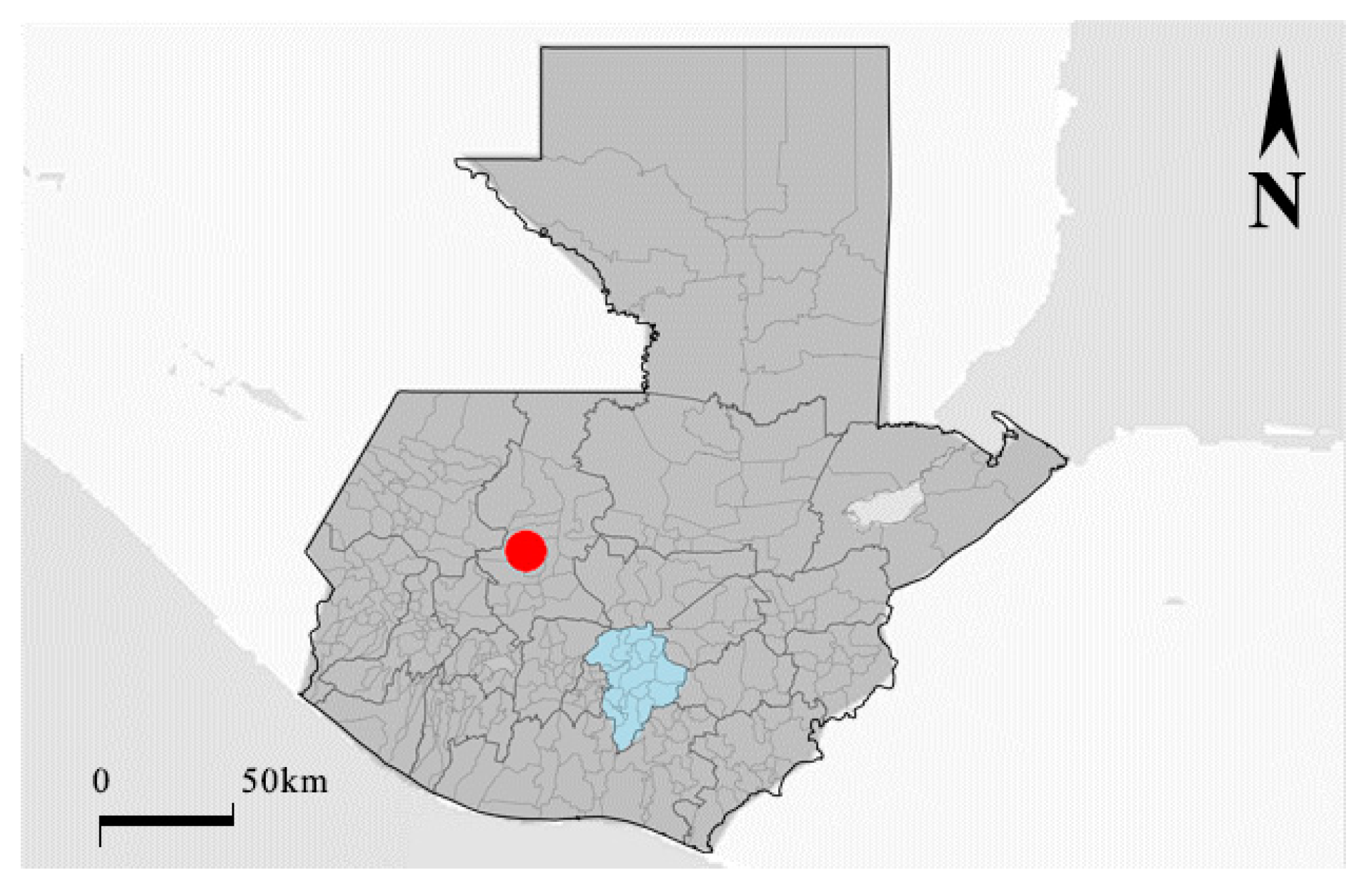
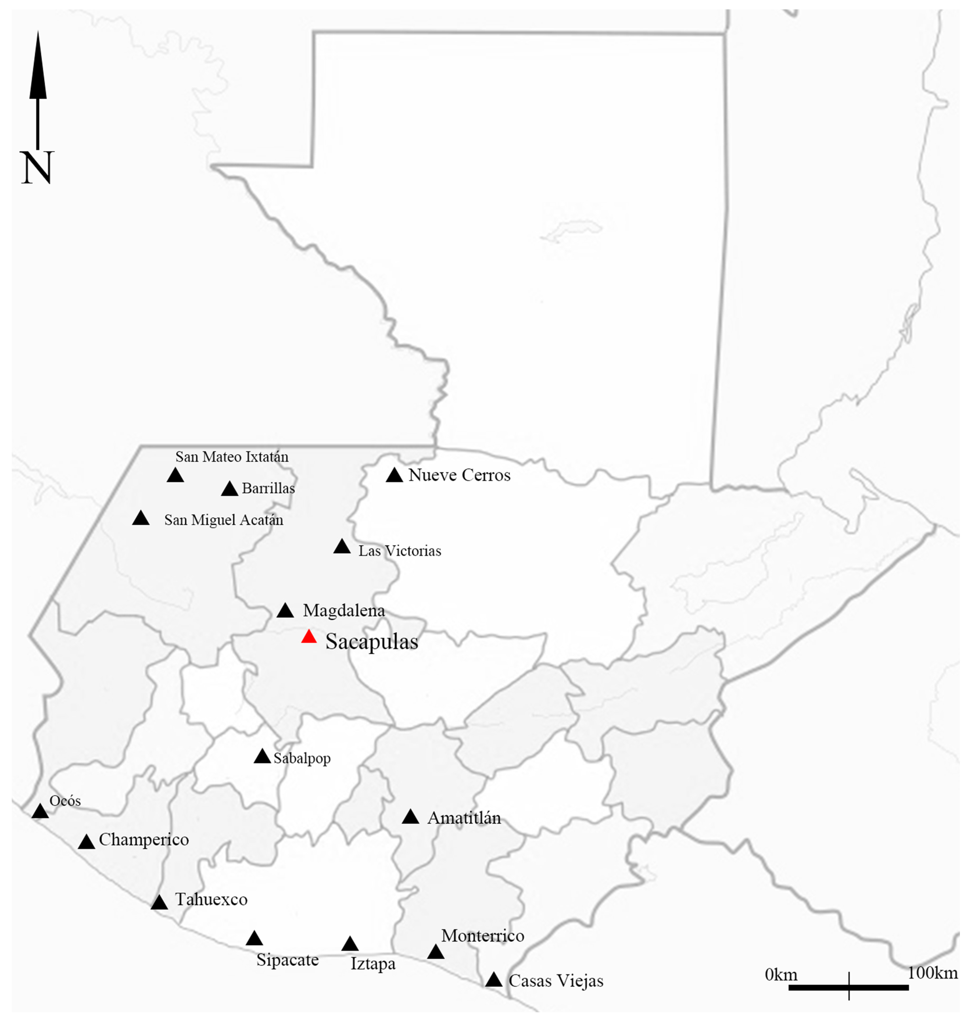
Guatemala is a country located in Central America, represented in
Figure 1 and
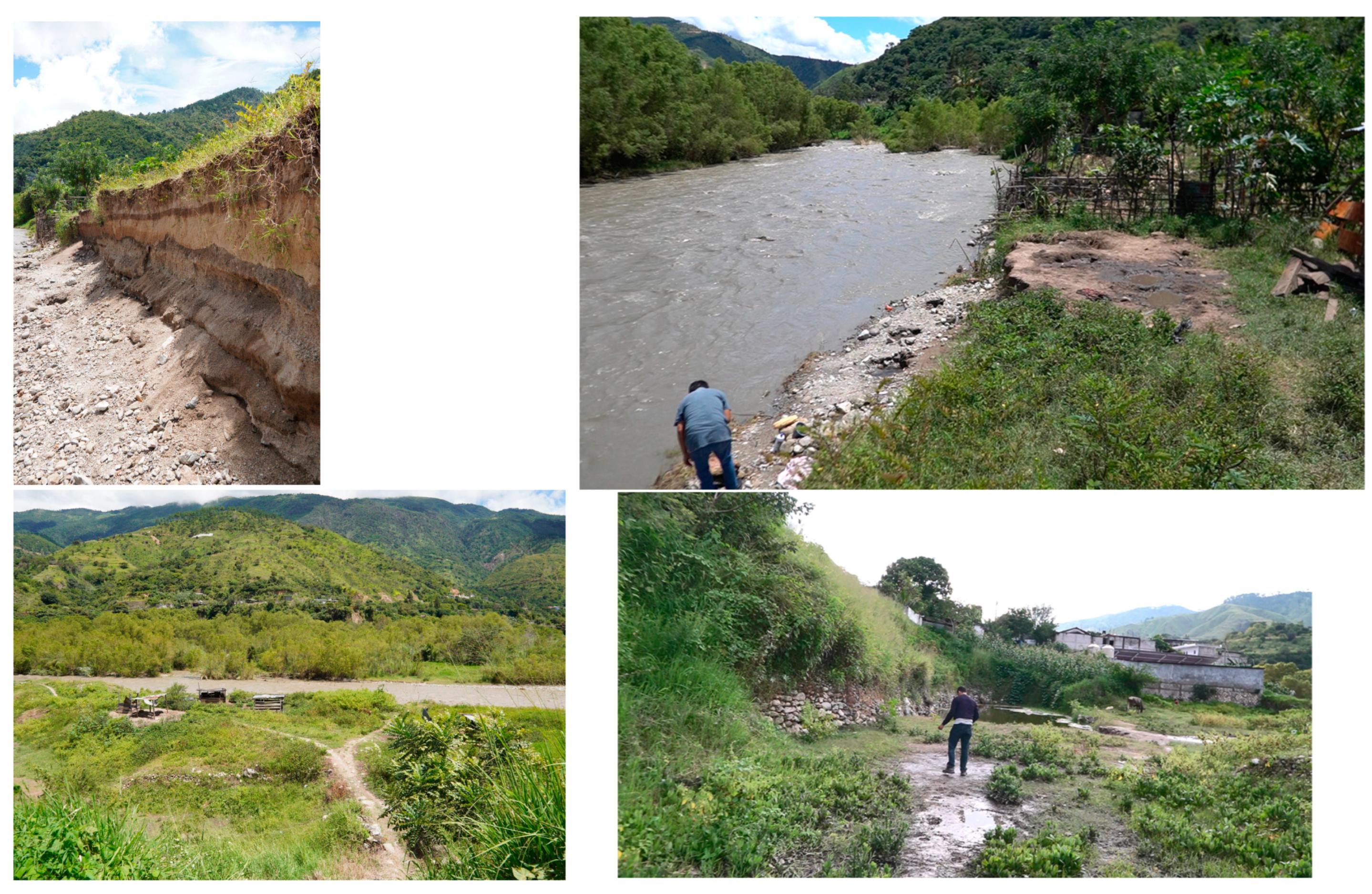
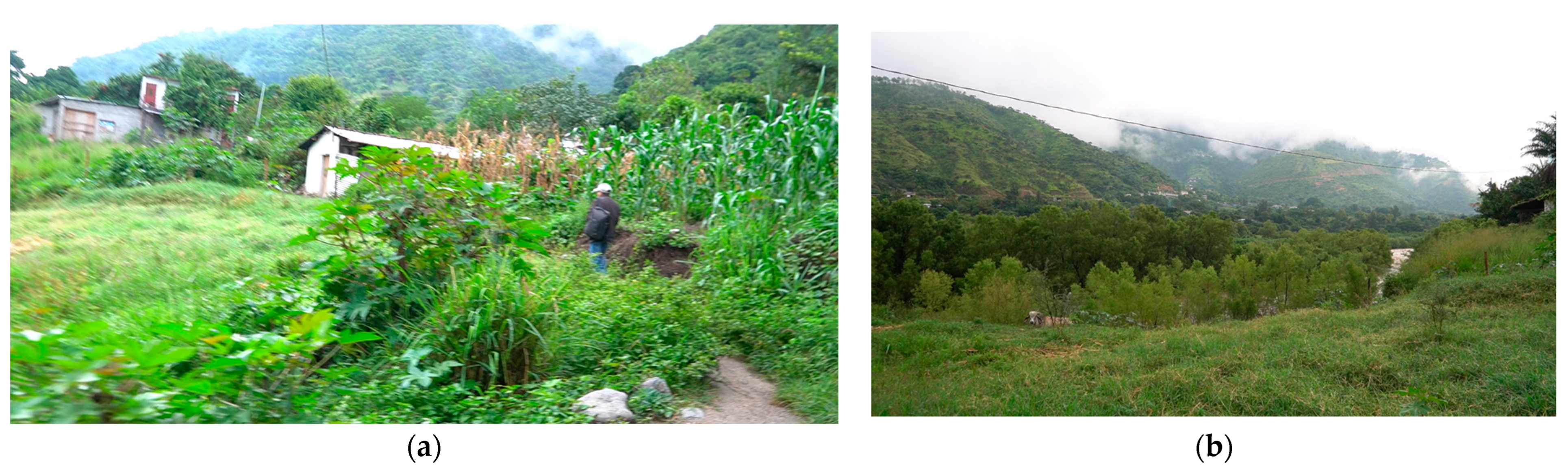
Figure 2. It has borders with Mexico to the north, Belize and the Caribbean Sea to the northeast, Honduras to the east, El Salvador to the southeast, and the Pacific Ocean to the south. The country’s territory is primarily mountainous due to the "Sierra de Los Cuchumatanes," a mountain range throughout Central America. As a result, topographic elevation varies from 500 m to 3800 m. Rural towns and cities are located all across this terrain variation, resulting in many people living in mountainous, remote areas.
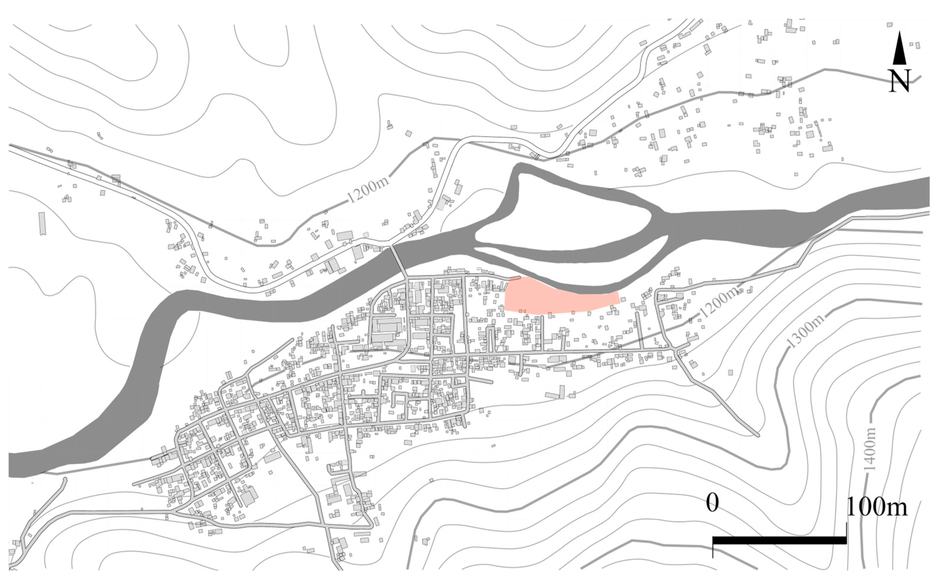
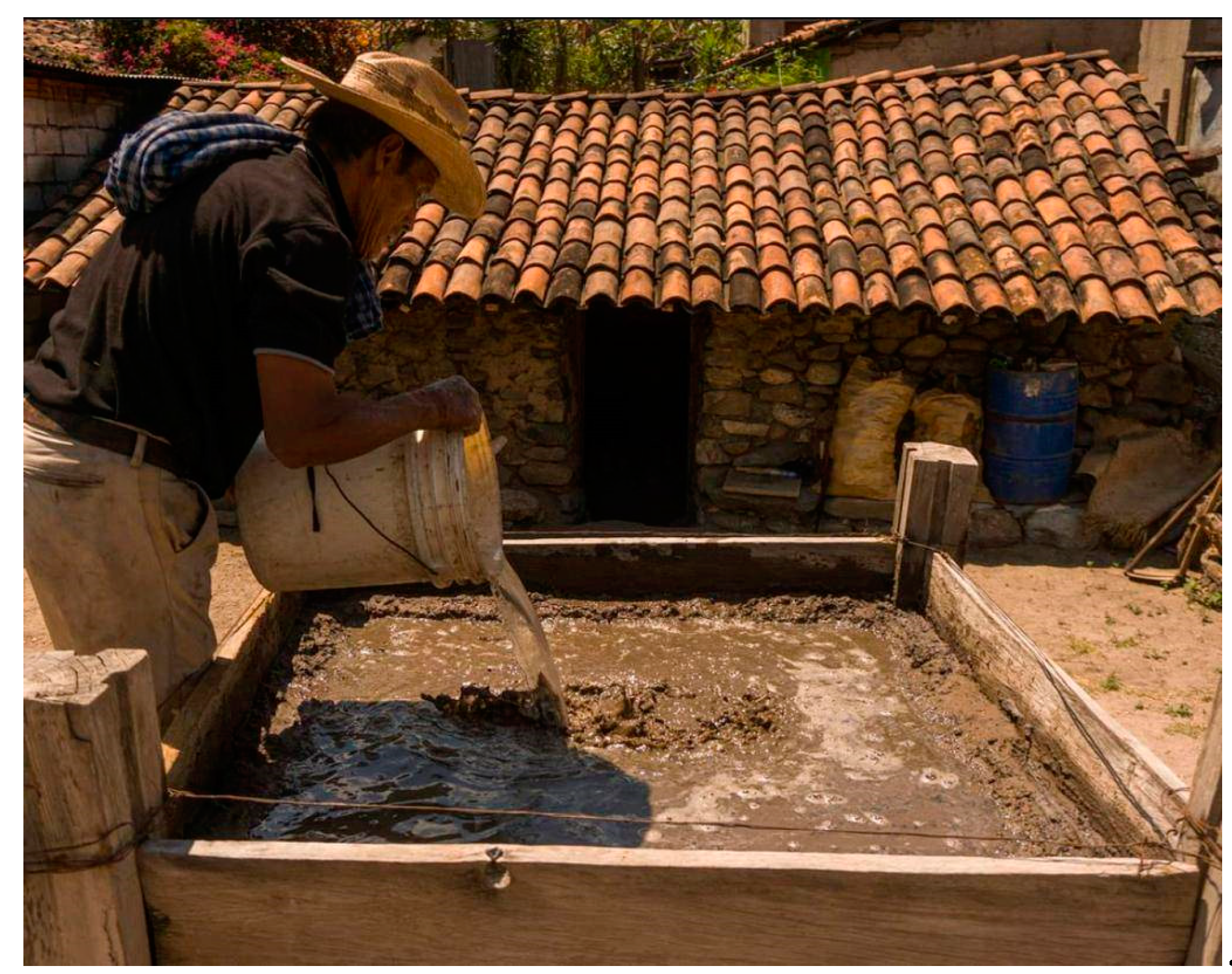
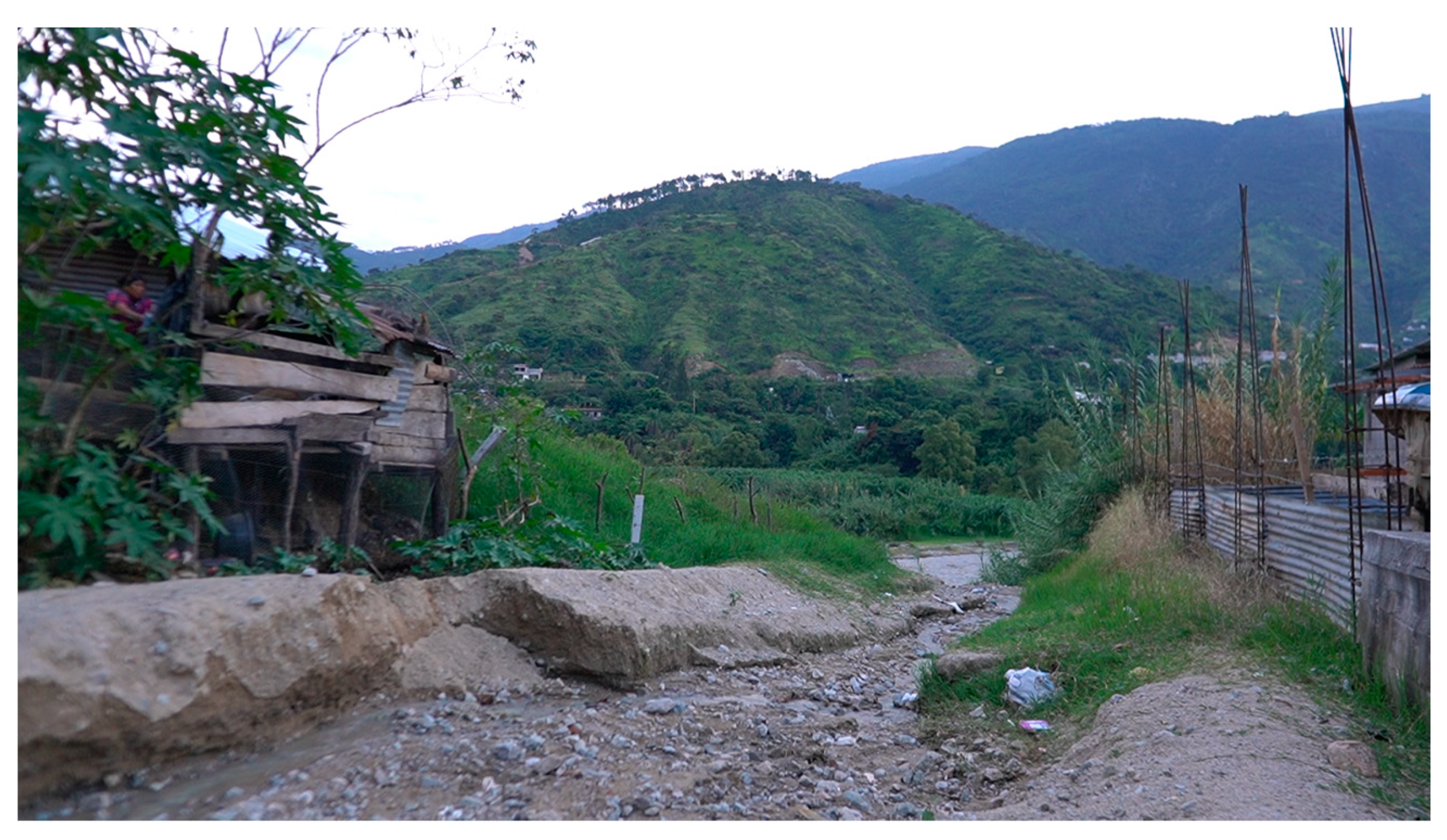
Inside the Cuchumatanes mountains is located the town of Sacapulas. While the region has developed steadily, communication is slow due to its current location, resulting in difficulties sharing the local culture. These difficulties have resulted in almost no current research being conducted in the area. Next to the town is the Chixoy River. This river runs through much of the northwestern territory of Guatemala and flows into southern Mexico. Across the river can be found salt deposits in the form of white spots, while the beach presents a source of thermal water. Both of these resources are used in the process of the black salt, which
Figure 3 and
Figure 4 depicts. Because of its traditional way of being made, when cooked, it results in a black color with attributed medicinal properties that the local population benefits from [
26,
27].
Current research in the area has successfully identified the situation of the salt beach. At this moment, the salt beach comprises a surface area of 4873.42 m2, of which almost 57% is covered by soil. As mentioned before, this soil comes from constant flooding from the Chixoy River. Of this area, only 5% has been excavated and is used for the salt industry. The rest of the area is used for what seems a small array of activities, such as using the small shore of the beach to bathe due to hot water found in the area; cattle rising occurs all across the covered salt beach; and people use the space to move within the town of Sacapulas.
1.2. Objective
At this moment, research conducted towards the spatial and architectural features of the area has yet to be conducted. The importance of such a point of view resides in the relation between these two subjects and how they adapted due to the natural disasters of recent years. Therefore, this research is aimed specifically towards the black salt kitchens. It seeks to identify their current situation, usage, location, and relation to the black salt beach. Secondarily, it seeks to document the architectural information of the kitchens through architecture planimetry.
1.3. Limits
Considering the amount of information yet to be researched about the subject, several limits were imposed on this research. Firstly, this research will not consider the other cultural expressions that exist in relation to the black salt other than the architectural elements. To locate the kitchens, only people related to the black salt industry are considered, as they present the information firsthand. Finally, the research area is located across the current black salt beach. Previous research suggests that salt kitchens were located at the north of the black salt beach, yet this area is currently flooded and access to it is impossible.
1.4. Current Literature
1.4.1. The Salt in Guatemala
The nature of this research is not about the overall situation and history of the Salinas, but a general understanding of its characteristics will be discussed to understand its context, from an architecture perspective. The traditional salt industry in Guatemala spans the entire Pacific Coast from the Suchiate River on the Mexican border to the border of El Salvador. According to Andrews, several hundred salt sources are located along the shores of the Pacific. According to Andrews, all of the salt produced on the Pacific coast of Guatemala was made by a process known as “cooking salt”, which has more than 2000 years of history.
Figure 5 depicts the major salt sources according to Andrews, which are located mostly on the west of Guatemala. There have been accounts by Spaniard chroniclers that described in detail the process to cook the salt. It is generally understood that it involves a three-step process: placing the soil impregnated with salt, filtering the soil with estuary water, and then cooking the result inside a clay or ceramic pan (“
olla” in Spanish). While Andrews mentioned replacement of the pans with a more convenient vessel made from iron called “
perol”, this eventually transitioned to the usage of ovens. Interestingly enough, Sacapulas uses what is known as a “salt kitchen” as a space where the salt is cooked. Plenty of modern research mentions the salt kitchens as a novelty and an important factor for the fame of the Sacapulas salt. Yet, a specific analysis of this architectural element has been extremely scarce.
1.4.2. Salt Industry Formation
Thanks to archeological data found in the region of Ocos and Champerico, it is understood that the industry of salt began around the Formative Mayan period and was underway 2000 [
26] years ago. Meanwhile, Spaniard chroniclers mention the existence of the salt industry to a degree of novelty [
26,
28], being conducted exclusively by natives. While the territories used for the salt industry were eventually divided with Spanish colonizers, the salt industry remained stable until the introduction of new technological innovations in the region. The previously mentioned ceramic pans, iron vessels, and ovens did increase its production, but the introduction of solar technology marked a noticeable shift in the local production. In fact, Andrews mentioned the increased use of solar evaporation as the main reason for the decline of cooked salt in the region. This is true, as, comparatively, solar evaporation yields more product with less effort [
26]. The usage of this technology was slow though; it was introduced during the 1920s and it became the dominant method of salt creation until the 1950s.
There are mentions of the complications due to the salt making process, both inside and outside of the salt industry, by Andrews, influencing its disappearance in the future. Firstly, the lack of natural resources such as firewood results in its disappearance. Secondly, the benefit of large agricultural and ranch spaces has led to deforestation. It is important to note that rural areas in Guatemala benefit mostly from these two economical activities, which makes them more attractive to people. In turn, cooked salt is both labor-intense and low yield compared to other salt methods.
1.4.3. Salt Making and Sacapulas Importance
The value of Sacapulas salt goes beyond its traditional method of production, as cooked salt is not specific to the town. Instead, its value comes from the historical background that it represents to Mayan history, the cultural expressions born from said industry, and the attributed value that is given by people that know about this product. Specifically, Sacapulas black salt is considered a famous type of salt due to its attributed health benefits, though no research has been conducted to validate or deny such a claim.
Figure 6 depicts the process in which it attains its famous black color: the salt cooking process. Nevertheless, it has been reported by many researchers as an important factor of its notoriety [
26,
27]. This kind of salt making specifically uses an area known as “Salinas”, which comprises a beach located north of the town of Sacapulas, and south of the Chixoy River. Most of this space is currently covered with alluvial deposits due to the constant floods caused by the river, which both Andrews and current research have confirmed as a constant issue. Specifically, Andrews mentions that at the time of his research, the space was covered with “as much as 2 m of alluvial deposits”. Historical accounts place Sacapulas in a favorable position due to its location in relation to major trading routes. Its location is along the Chixoy River, which constitutes the east–west salt trade in the region. It is also located in a favorable position towards the Atlantic lowlands due to the Chixoy River being connected to the Usumacinta River. Its location was attractive to the Quiche region, as its location made it an important economical center. This resulted in the kingdom of Quiche eventually incorporating the town into its control until the arrival of Spanish conquerors. Colonial and modern history has shown considerable information on the Sacapulas industry, with recounts such as Titulo de los senores de Sacapulas and Spanish chronicles as important resources to understand the position that the town had for the Spanish crown and local Mayan people. Current research has focused on the actual state of the beach, and understanding how it has evolved due to the decline of salt making in the region. Traces of the importance of Sacapulas salt making still exist. An example of this is the current trading routes in the region. According to Andrews, the trading routes used by Mayas during the precolonial times were adapted by Spaniards and even used by current traders. Such examples exist, like the trading routes towards south and central Quiche, which are a pattern that dated to the XIV century when Sacapulas was integrated into Quiche. It was also mentioned that the salt route to the west was very old. This is due to the fact that salt tributes were found in the western region of Guatemala, tributes paid with Sacapulas salt [
26].
Historically, the importance of the black salt industry is found in several mentions by Spanish conquistadors and Mayan mythology related to the region. Specifically, chronicles written after the conquest mention the Spanish conquistadors’ interest in salt creation. The earliest mention of salt is a report by three Franciscans in 1579 [
28]. This report relates the conquistadors’ need for salt and how, for this reason, salt had to be obtained from Sacapulas. The salt makers were referred as “salineros” (Salt workers), and received a part of the salt as payment, which they eventually sold in their communities. The next mention of salt consisted of impressions by the Spanish colonizers. This recollection was written and reported by Martin Alfonso Tovilla, the mayor of the province of Vera Paz, Golfo Dulce, Sacapulas, and Manchen. His report to the Spanish crown was compiled in the book “Historicas Dyscriptivas” (Descriptive stories) in 1629. On this occasion, he mentions the importance of salt in the gastronomy of the locals, as they “do not do or want anything more than corn tortillas and a little chili and salt, which makes them happier than if they were eating turkeys...” [
29].
Tovilla also mentions that the area’s importance was also perceived as high because it was one of the few regions which produced salt. This importance was critical with the political situation of Sacapulas, as the riches were a point of issue with the Quiche kings and their kingdom located in the ruins of “Gumarkaaj”, south of Sacapulas (around one hour of driving). Prisoners of war were commonly captured and forced to work in the salt industry. Tovilla concludes by giving his opinion regarding the low price of black salt compared to the volume of wood necessary for its creation, finding the process too exhaustive for the price it is sold. He said the rate was around fifteen “cakes” (salt molds) for one “real” (currency at the time).
Little research has been conducted in recent years, the latest being on the importance of black salt. This is found in the anthropological book “Traditions of Guatemala,” which defines black salt as “a resource of great importance” [
27]. In addition, there is evidence that various tributes were made in the form of salt during colonial times, proving that salt was considered an essential and valuable product for the Spaniards and the natives [
26].
1.4.4. Salt Kitchens—Architecture Specific to the Industry
The area known as the black salt beach has been afflicted by constant flooding. This is due to the location of the Chixoy River in relation to the town of Sacapulas [
24]. The result of the constant flooding and loss of space is a reduction in people active in the black salt industry. Consequently, the tools used in salt making have also ceased to be used. In this case, the “traditional salt stove” is one of the essential tools in salt making, known locally as “salt kitchens”.
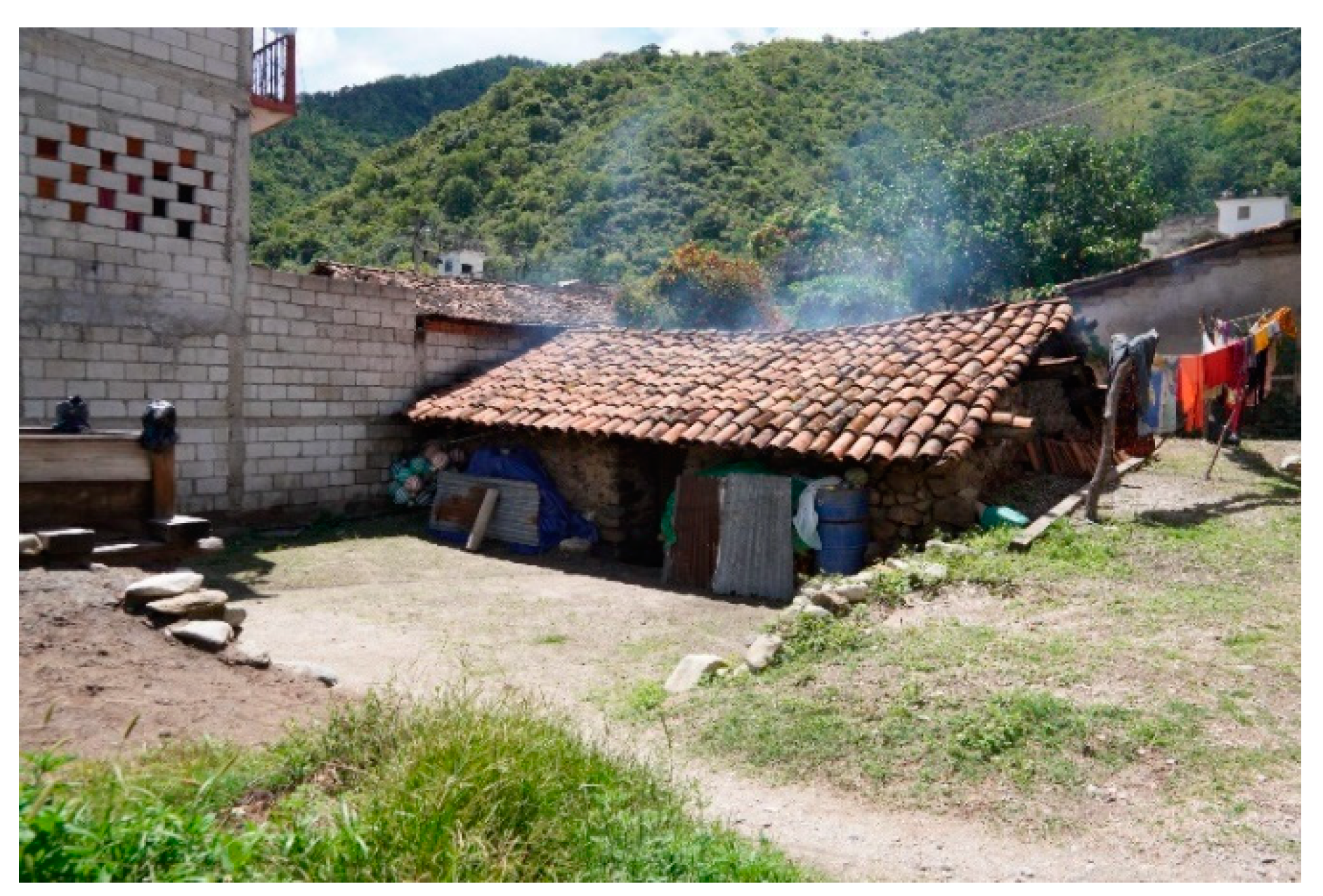
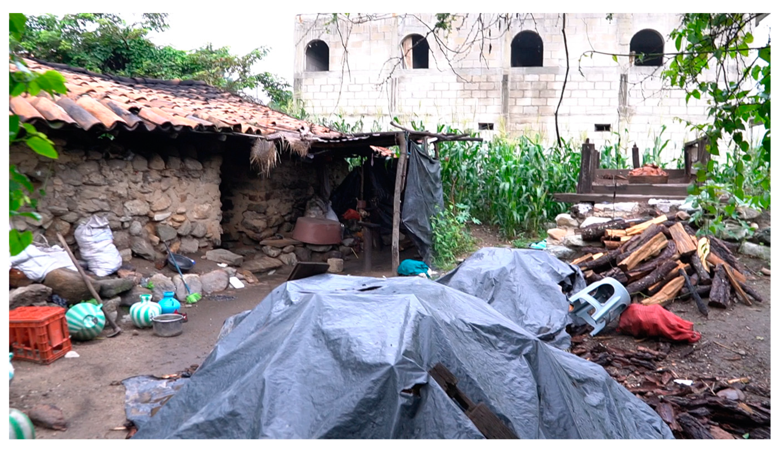
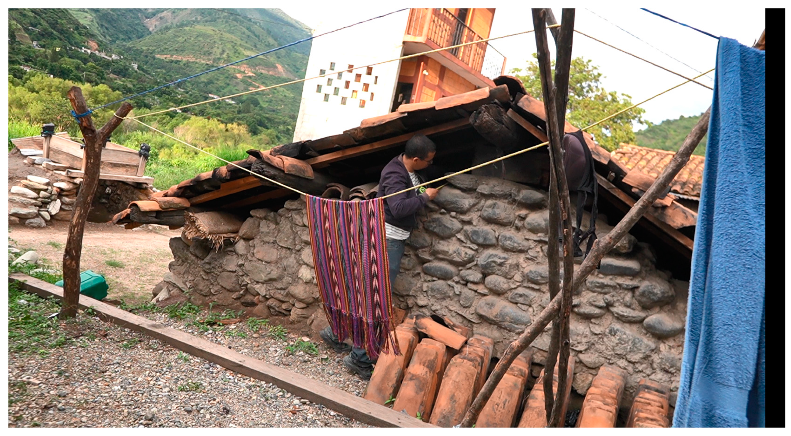
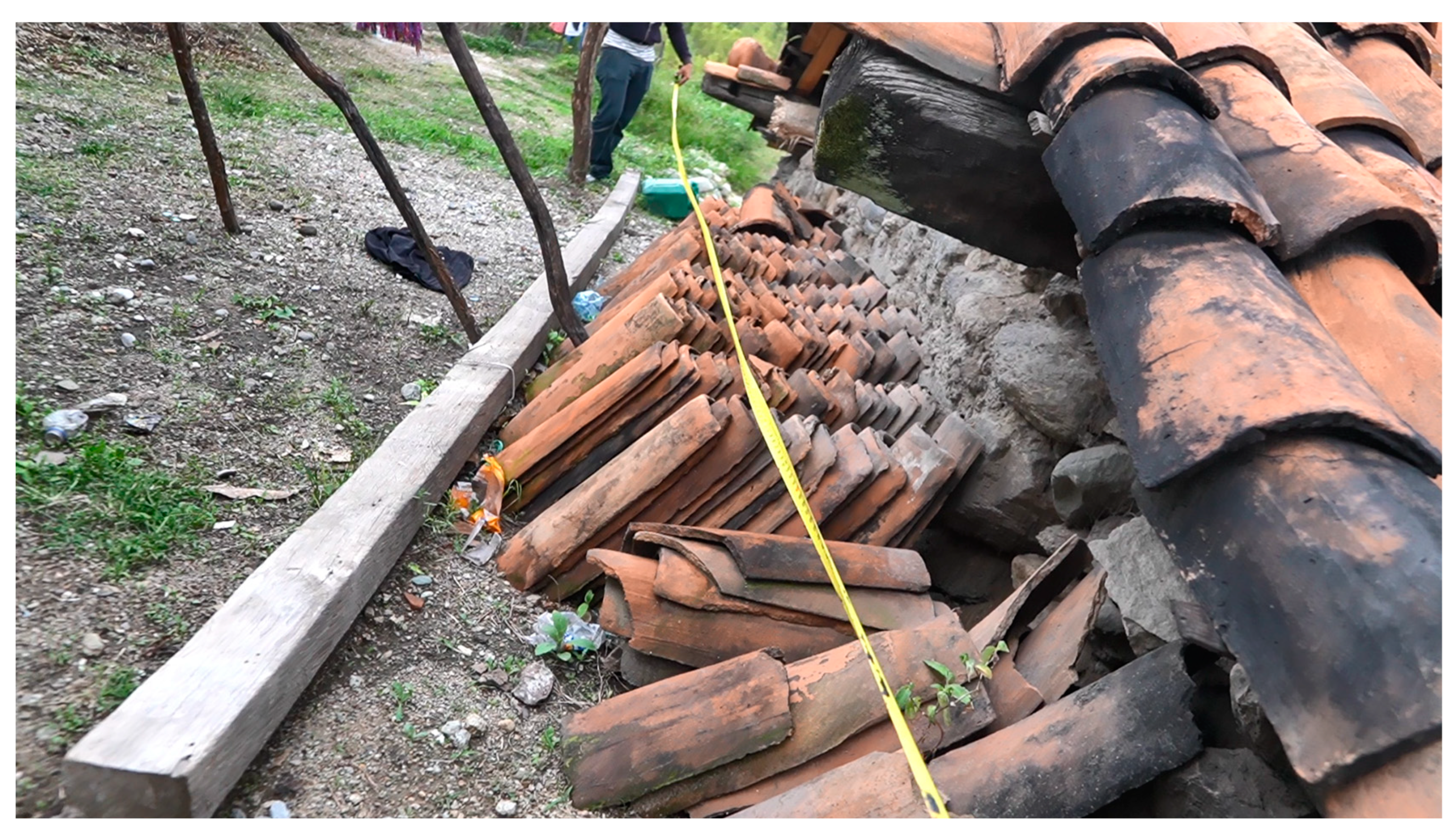
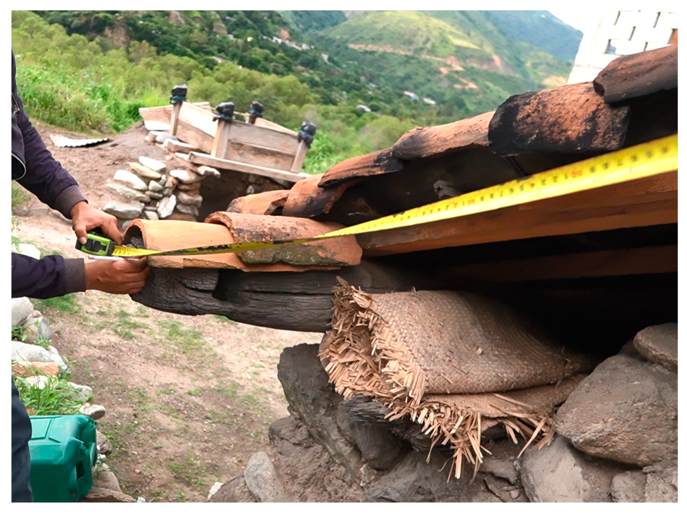
Figure 7 is an example of this architecture. These constructions are concentrated above the black salt beach and comprise two essential elements: the main kitchen and the distillation box or dripping area. The kitchen comprises an enclosed space needed for cooking salt. It is a small room excavated underground, surrounded by stone walls [
30]. While the construction of the walls is rudimentary (it does not present any internal structure), the gable roof presents a wood structure.
1.4.5. Cajón and Pila de Destilación (Distillation Box and Basin)
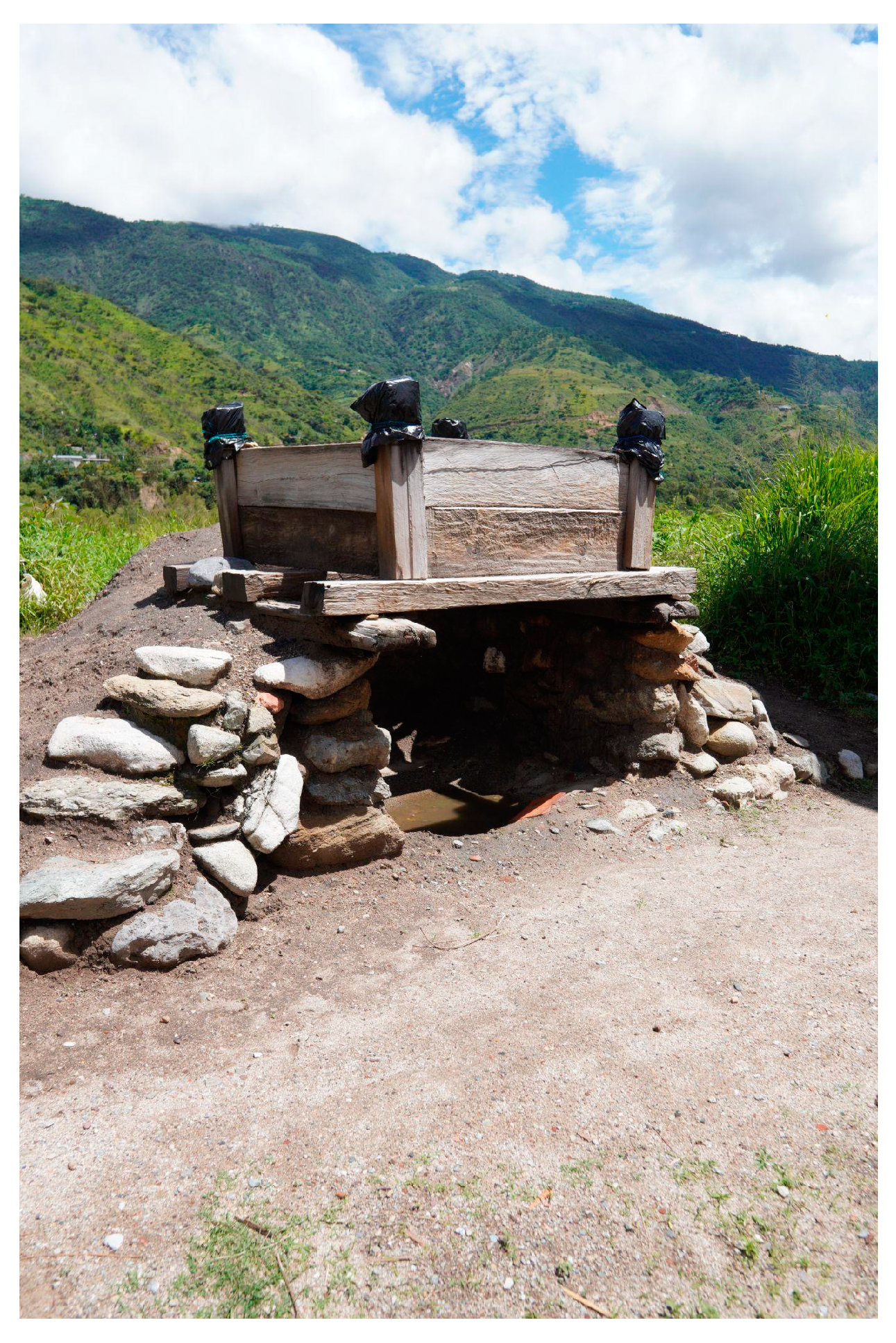
In front of the kitchen, on the outside, is the salt preparation area represented by
Figure 8. It comprises the distillation box denominated “cajon”, an element usually 1.68 m in diameter and 1 meter deep. While the main structure is of wood, the box floor is made of wooden rods or cane and matting, named “petate”. The box is placed on top of stone walls, on a mound of earth, at a certain height. Underneath, the distillation area or basin is built. Its function is to distill the salt using the thermal waters found around the beach shore. This step is crucial as it happens before cooking the salt in the kitchen. The basin is made of brick and stone, glued with mortar. The basin has the necessary capacity for eight “tinajas”: a traditional plastic jar used in rural areas.
1.4.6. Features of the Salt Kitchen
The architectural language found in the kitchens is of something other than Maya origin, which suggests that they were created after the pre-hispanic period. This fact is alluded to by Tovilla’s text, which does not mention the use of specific architecture to create salt. Also, the use of clay tiles in roofs as an architectural element started after the conquest, and did not originate from the region. However, Ruud Van Akkereen mentions in “Titulo de los señores de Sacapulas” that the pre-hispanic name of Sacapulas comes from the name “Tuja” or “Tujalá” [
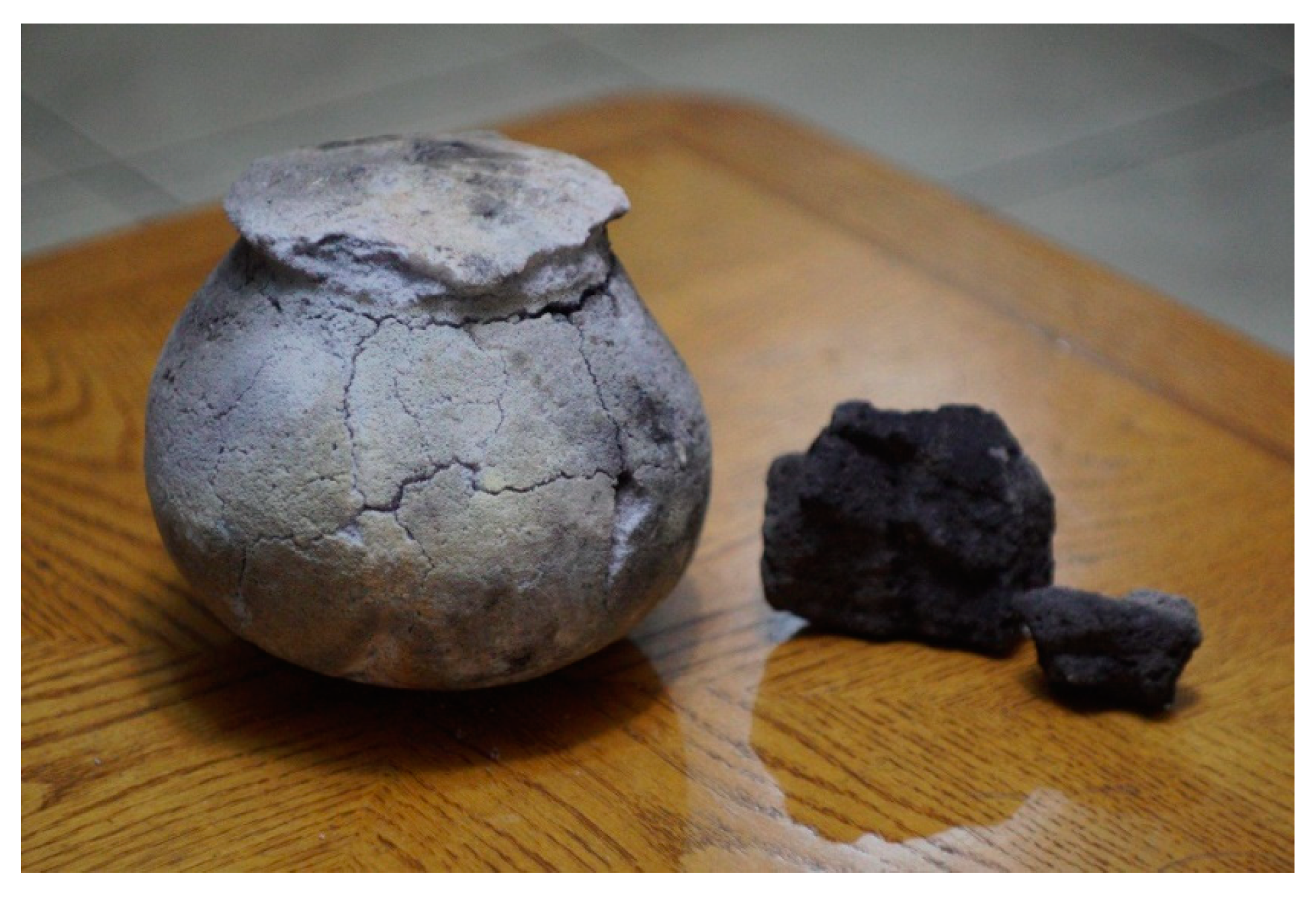
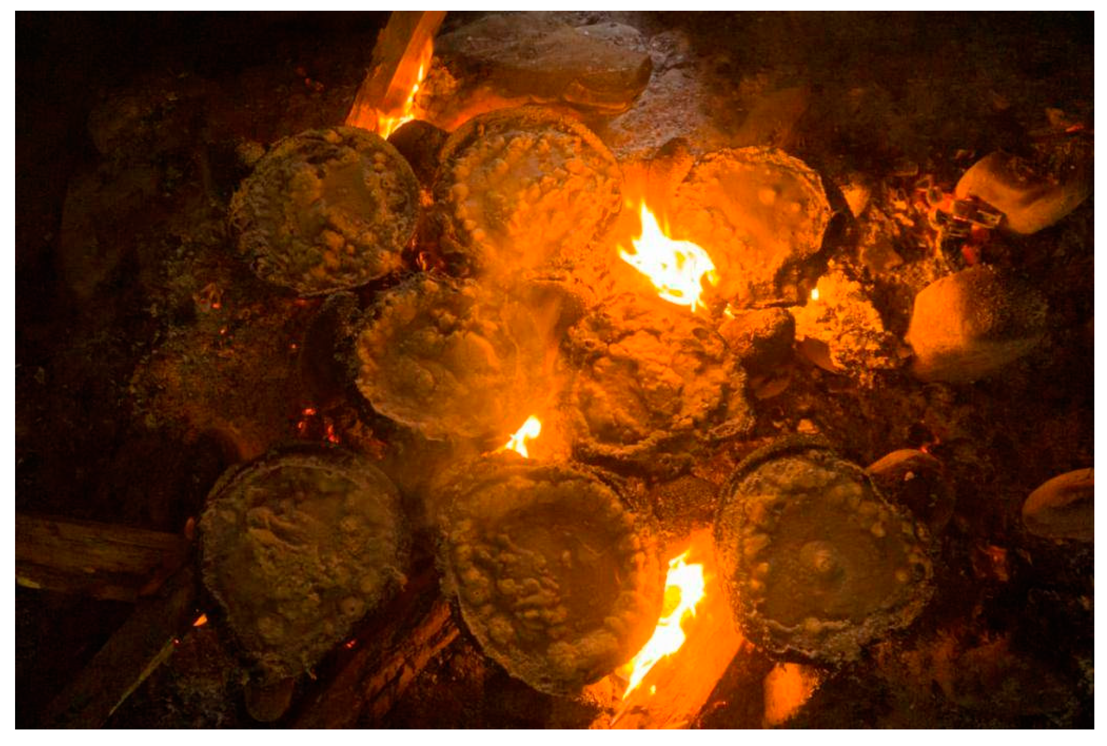
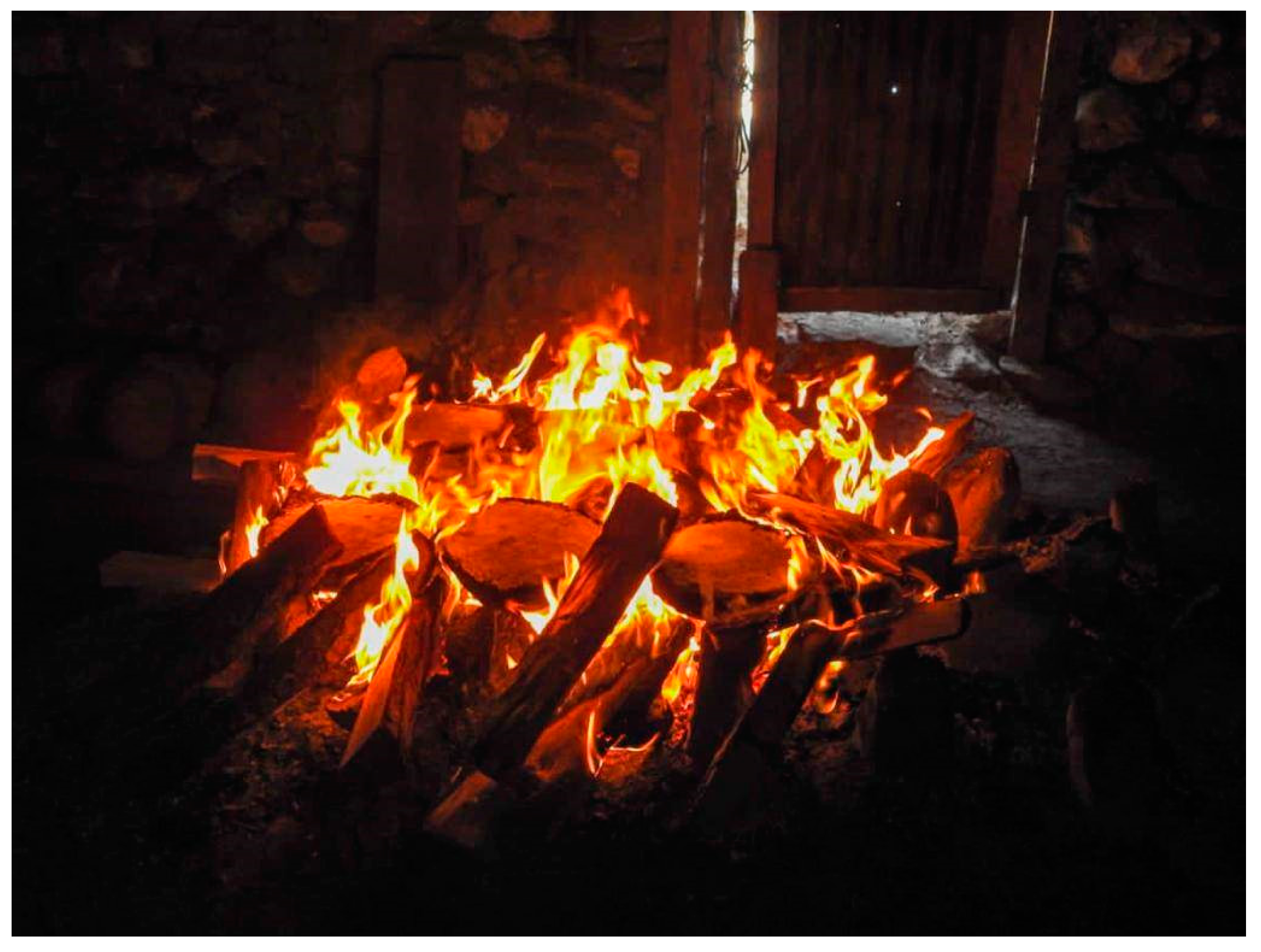
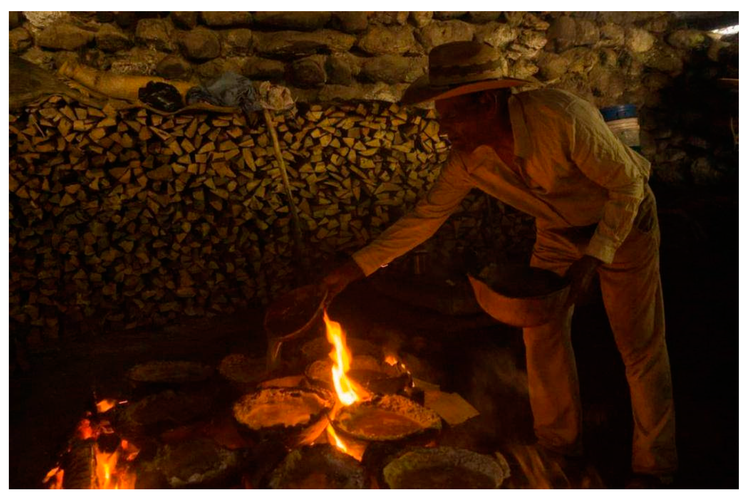
31]. He mentions the possibility that tuja refers to the low houses where people worked the black salt. Thus, there is a possibility that this architecture existed in pre-hispanic times in a different shape. There are discrepancies regarding the height of the salt kitchen. According to Reyna, the total height of a kitchen is 2 to 2.5 m (one meter underground, the rest over ground level), with measurements of 6 × 8 m. Ordoñez mentions between 3 and 4 m in height, with no mention of its measurements. The primary tool found inside the salt kitchen is the “heart of the fire,” a slight mound of earth measuring 1.67 × 5.02 × 0.41–0.84 m wide, located in the center. On it, 40 tenamastes are placed: pointed stones taken from the Chixoy River. Over the tenamastes, “cajetes” or pots made from animal feces or clay are placed with the previously distilled water inside. These are usually used only once due to the fragility of the material. Also, the differences in temperature result in many of these pots being broken after they are used (
Figure 3). The salt creation process is detailed in
Section 1.4.7.
New kitchens are not built due to the small size of the salt industry. For this reason, maintenance must be performed to keep them usable. Maintenance focuses specifically on the roof structure comprising wood. This is replaced every two or three years due to the high intensity of the fire. In contrast, the tiles used on the roof are cleaned, not replaced. Informants estimate that the tiles are over 100 years old [
27]. Due to the scarcity of kitchens, Ordoñez reports that salt kitchens can be borrowed or rented. The price is Q10 (USD 1.27) each time they are used or Q100 (USD 12.77) for a season from January to April. Another important fact is that the “heart of the fire” can be shared among salineros, which can help divide the cost of rent between two or more workers. Finally, throughout the off-season, salt makers aim to extract enough soil with salt to cook throughout the year. Thus, the salt kitchen also serves as a warehouse storing potential economical revenue to the salt maker.
1.4.7. Salt Creation Process
Understanding the value of the black salt’s architecture and industry requires knowledge of how the product is made. The process initially mentioned by Alfonso Tovilla is the same as the one used in 1978, reported by Reyna and Monaghan, and by Amilcar Ordoñez in his 2001 research [
27,
30]. It should be noted that the process Tovilla mentions is described in general terms compared to Reyna and Monaghan’s work. An element that has not changed has been the tools used in the salt creation process, which implies that the work process has not been optimized with new technologies. The process mentioned by Tovilla, and Reyna and Monaghan consists of two main parts: the “sowing of the salt”; and the cooking and subsequent finalization of the product. The first step of the process (“sowing the salt”) is a method of salt germination involving the beach’s specific temperature and soil obtained from it. Due to the nature of this research, the process is summarized in the most important steps for its creation. Therefore, this is a compilation of the steps mentioned by both Reyna and Monaghan and Ordoñez in their respective investigations.
As mentioned previously, salt production only occurs during the dry season of the year (November to June). However, the salted soil obtained during these months is stored and produced as salt throughout the year. Usually, the salt kitchens serve as a salt creation area and salt soil storage for future work. The work begins in the morning when the salt maker spreads special, clean soil on his or her part of the beach, no more than one centimeter thick. The documentation does not mention why the soil used is special. The land of the beach is measured by “petaquilla,” a specific informal measurement unit that equals 12 square varas (Spanish measure equal to 8.385 sqr m). Then, he fills a tinaja with thermal water obtained from one of the many open wells on the beach. With half of a gourd, he hydrates the soil so that later the sun heats the beach enough to make the salt sprout and impregnate the soil. According to the report, this process is conducted for three consecutive days until the salt maker, from his own experience, decides that the soil has enough salt impregnated. The next step is the mobilization of the soil to the salt kitchens.
Figure 9 and
Figure 10 depicts this part of the process.
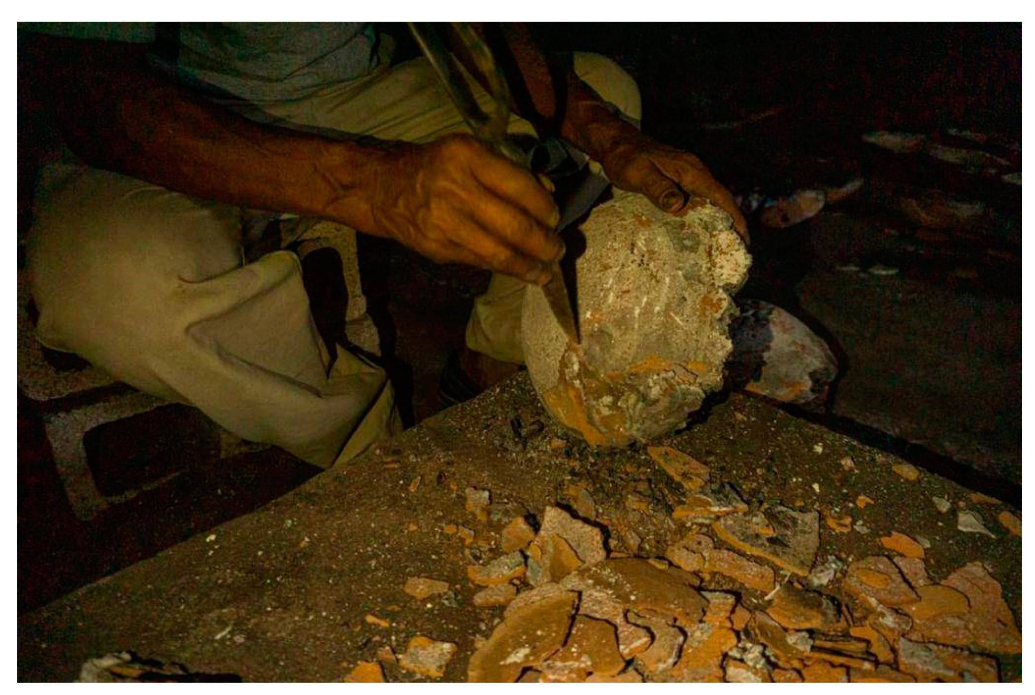
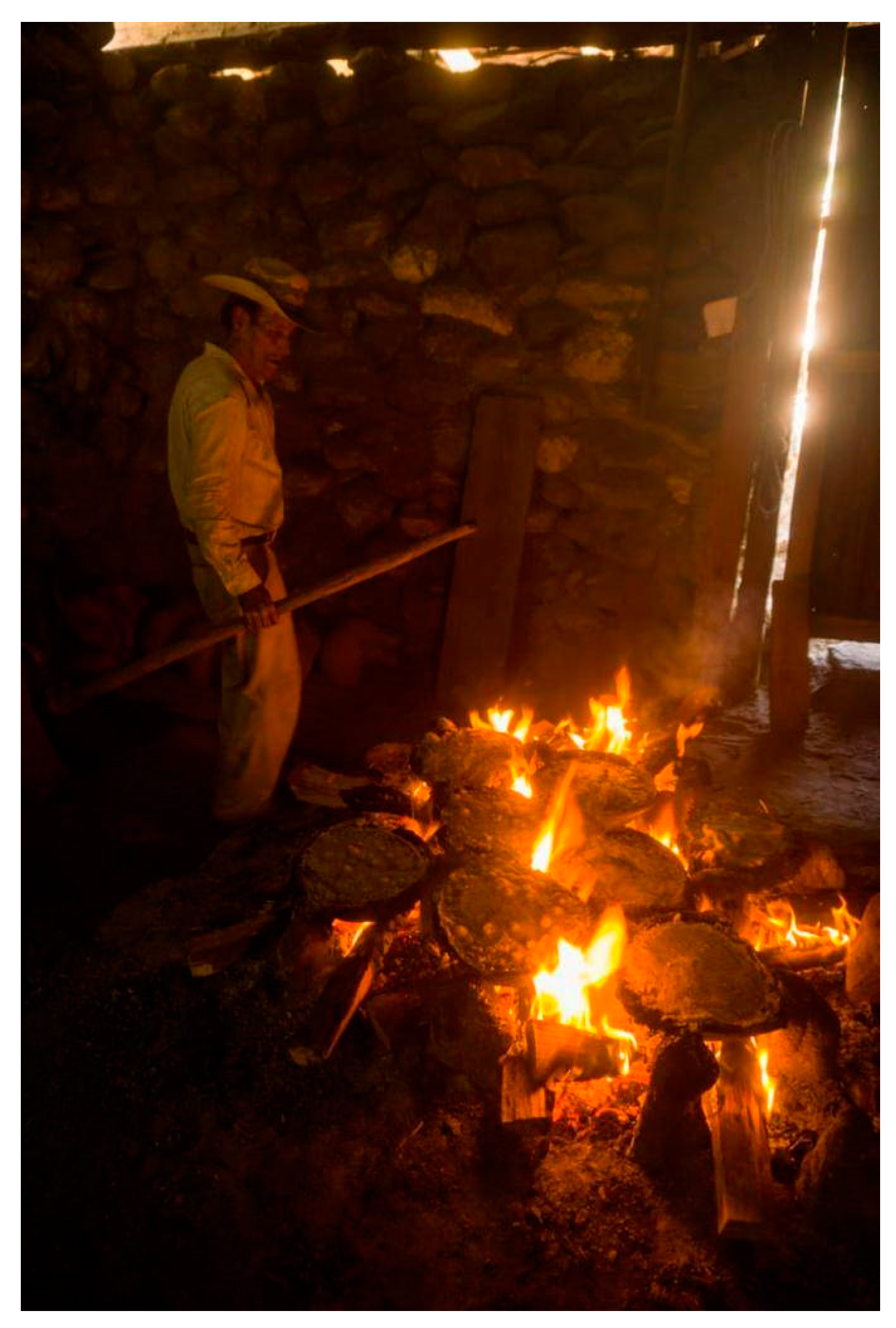
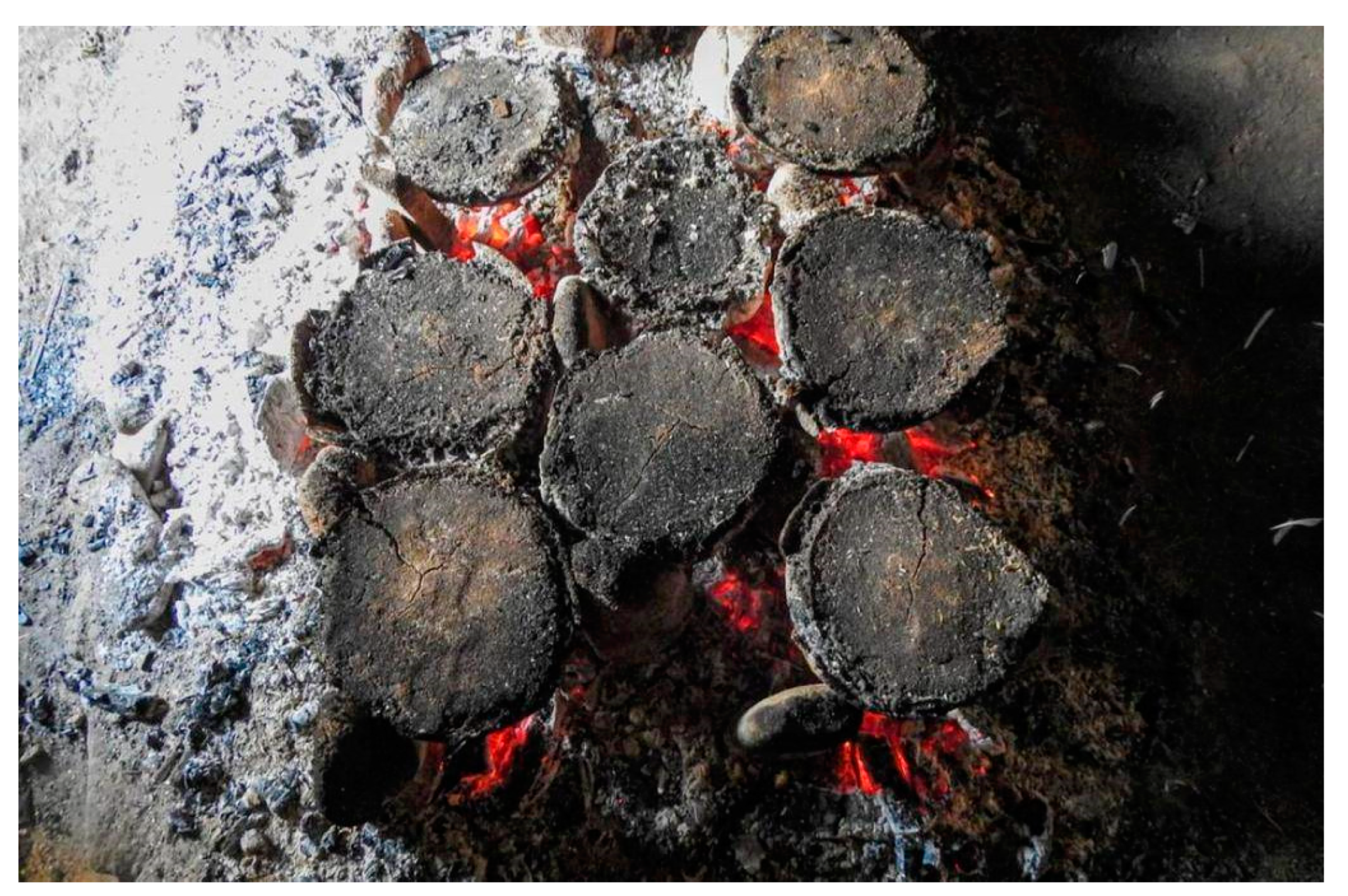
The salt is transported to the salt kitchens on foot. Here, the soil will be distilled one petaquilla at a time. The soil is transported to the front of the kitchen, where the distillation box and basin are located. The salt is placed in the box, separated by a few m from the ground. The next day, the hot water from wells on the beach is poured in, a process that takes from 5 a.m. to 3 p.m. (10 h). At the end of the process, the soil is removed, and more is hauled back to start again. The result is distilled water with salt, or “aguasal”. With the filtered salt water, the salt maker creates the “heart of fire”, a rudimentary oven in which the salt molds are placed on the 40 tenamastes. The cajetes are heated with salted water inside and cooked for 5 to 6 h to evaporate the water. This process is called “burning” the salt. The next day, the pot is broken, and the salt lid is removed, ready to be sold.
Figure 11 and
Figure 12 depicts this process.
The resulting product of the salt workers is twofold: Atzam and Xuupej. Atzam is small pieces of white salt resulting from the burning of the aguasal three times. However, reintroducing the atzam into the heart of fire results in Xuupej, black salt [
27]. At the time of Reyna and Monaghan’s work, approximately 250 pounds of salt were produced in two days and sold at high or low prices, depending on the season. This fact does not seem to have changed according to Ordoñez’s research, where he mentions that each time salt is made, between 1 and 2 quintals (150 to 300 pounds) are produced.
Figure 13 and
Figure 14 depict the last hours before the salt is finished.
1.4.8. Number of Salt Kitchens
The total number of kitchens is a mystery; in 1981, Reyna and Monaghan mentioned the existence of 11 salt kitchens. Meanwhile, Andrews mentioned on his 1983 research that there were 14 salt kitchens standing. However, in 2002, according to Ordoñez, only 6 kitchens were still in use during his research. According to Ordoñez’s informants, there were around 16 kitchens in operation previously. Ordoñez did not define the specific year the 16 kitchens were in use. It can be hypothesized that the small number is due to two factors: a reduction in the black salt industry results in the reinterpretation of the space of the salt kitchens for another, more economically attractive use. And second, the historical earthquake of February 1976, where most of the buildings suffered damage [
32]. According to Ordoñez, many areas of the black salt beach are now used as corrals and pigpens.
2. Materials and Methods
Black salt is a research topic wide enough but yet to be researched to a degree that access to information on it would be considered easy. Therefore, the lack of information has resulted in a complicated starting point for any person interested in the subject. A good way to address this challenge is by implementing not only one research method, but a diverse array of techniques that cover a broader set of research questions. This is known as “triangulation” [
33]. The idea of triangulation is obtaining data from difference sources, varying the methodology, researcher, and/or theories. The triangulation approach is not an end in itself, but instead a tool to better understand a complex problem while also being effective in the time employed during the research. It also serves as a way to reduce the amount of personal bias the researcher might have, as different sources of information yield a more complete result. Finally, the relationship between quantitative and qualitative methods benefits from a triangulation approach, as it gives a better reach to the research while confirming or denying information from interviews. In the case of this research, the triangulation approach was used to complete the resulting dataset, with different information groups used for this process. Specifically, using the Denzin approach to triangulation techniques, “Methodological triangulation” was used. Of this group, “between method” triangulation was selected. This triangulation approach focuses on the usage of a variety of methods to collect and interpret data, and is used where two or more distinct methods are employed to research the same phenomenon—in this case, the relation of the salt kitchen and the salt beach. There is evidence of this approach being helpful in understanding disasters and local issues in Guatemala [
14]. A summary of the analyses performed is shown in
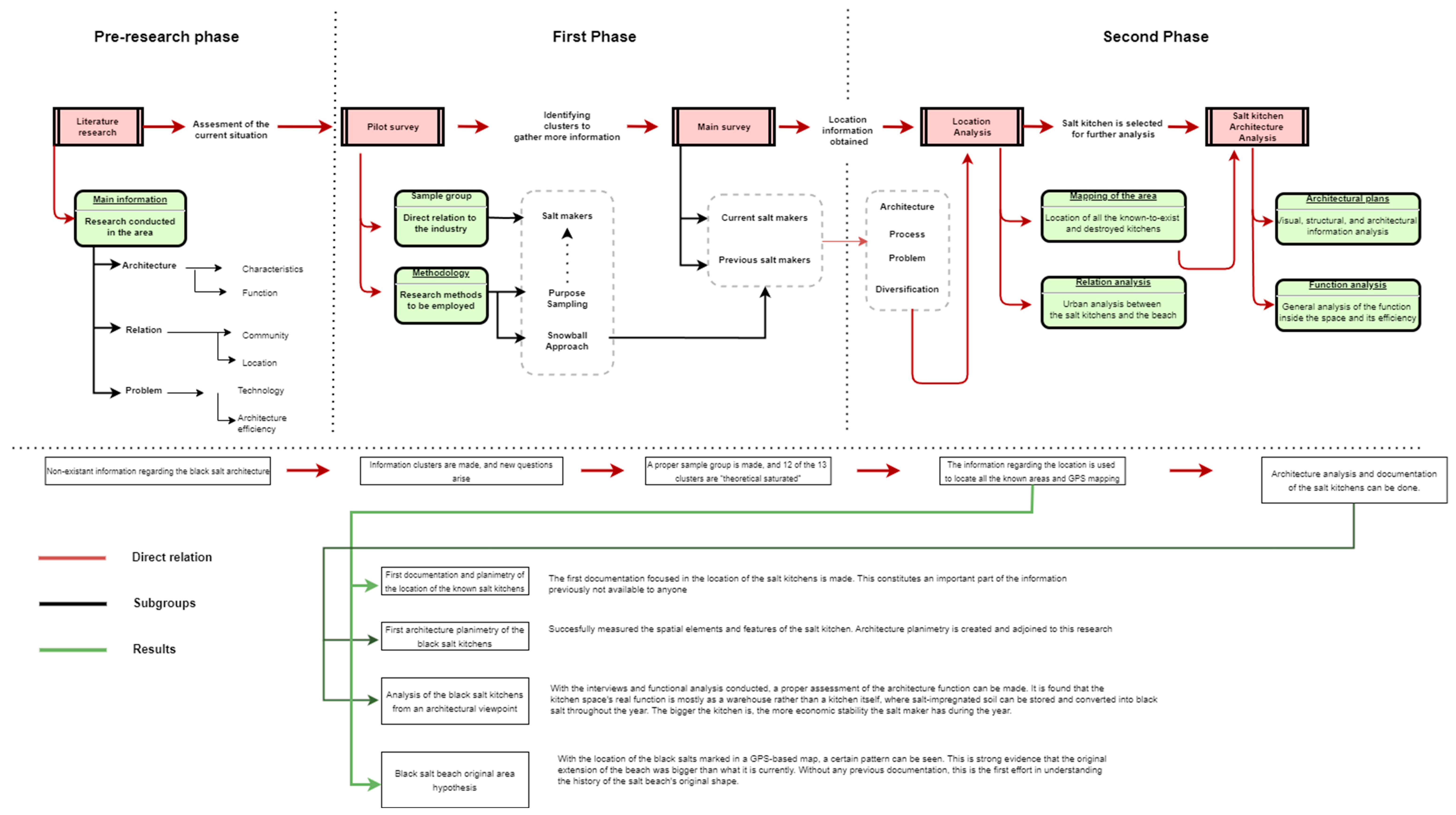
Table 1, while
Figure 15 depicts the methodology employed and the workflow conducted.
After selecting the triangulation method, we need to define the types of analysis to be conducted in this research. Three analysis types were selected for this research, ranging from qualitive to quantitative. The main analysis and information were obtained by interview. A certain part of the information obtained was used originally in the previous research conducted in the area [
24], yet part of the unused information was utilized on this follow up research by implementing new information specifically from the salt kitchen. This analysis was conducted in 2 parts, the first being an approximation of the area conducted in March to April 2022 as a pilot survey, and the second one being conducted in September 2022 as the main survey. The pilot survey was focused on specific interviews of a sample group of people who had a relationship with the black salt, using the “modified ground theory” as the main methodology employed. The “Modified Ground Theory” approach is based on the systematic method developed by Glaser and Strauss called “Ground Theory”, in their 1967 book [
34]. This qualitative method requires that the researcher start the investigation with pure data and no available theoretical background or knowledge of the phenomena. This is quite a challenge in the case of the black salt due to the complexity of the situation and the lack of information available: it is required to know the value of the industry and its relation to the people of Sacapulas. Therefore, a method which implements rough definitions and theories previous to the start of the research is needed while using the general “ground theory” methodology. This is called the “Modified Ground Theory”, and it facilitates the researcher by taking into account the context of the black salt beach and its kitchens [
35]. The result is a main dataset comprising qualitative information in the form of interviews, which was further completed in the second phase. The second phase was completed in September 2022 and focused on deepening the information obtained in the pilot survey by conducting a main survey. A further description of this method is found in
Section 2.2.1.
The next analyses are considered secondary due to their being dependent on the information retrieved by the interview phase. These are the “location analysis of the salt kitchens” and “Salt Kitchen measurements”. Location analysis is based on validating the information given by the interviewees regarding their knowledge of the salt kitchens. Due to the inexistence of these data, it required asking and then physically going to the spaces that were mentioned. After this, an inventory of their situation and usage of the terrain was conducted to update the current information of the architectural elements. This was supported by the usage of GPS tools to “map” their locations and eventually compare the data to the physical urban thread and distance between them. This helped not only understand the position of each element, but also to identify if there exists a pattern or a relation with the salt beach.
“Salt Kitchen measurements” refers to the measurement and construction analysis conducted on one of the remaining salt kitchens found in the area. Due to not knowing the specific location of any of the remaining salt kitchens (or their existence), this part of the research also depended on the previous two analyses conducted. This analysis focused on determining the general measurements of all the structural and architectural elements that comprise the salt kitchen. While information regarding these elements roughly exists in previous research [
30], it is not concise and does not present the required architectural documents to be used by people interested in the salt kitchens. In contrast, this analysis seeks to provide the measurements and visual information of each element found in the space while also analyzing its function. This is further explained in
Section 2.2.2,
Section 2.2.3 and
Section 3.1.
After defining the analysis to be conducted, the methodology was developed as a step-by-step process, dividing the overall research into two steps: the first analysis phase and the second analysis phase. The first analysis phase consists of the literature research and the interview stage. The literature research comprises the research of all available data on the subject on the basis of previous research in the area. All this has been discussed in
Section 1 and
Section 2. Meanwhile, the interview analysis comprises a pilot interview and a subsequent main interview. The resulting information was catalogued and analyzed, which helped move to the second phase. The secondary phase comprises the location analysis and salt kitchen analysis. This is further explained in
Section 2.1.2,
Section 2.2.2 and
Section 2.2.3.
2.1. Materials Descriptions
2.1.1. Interview
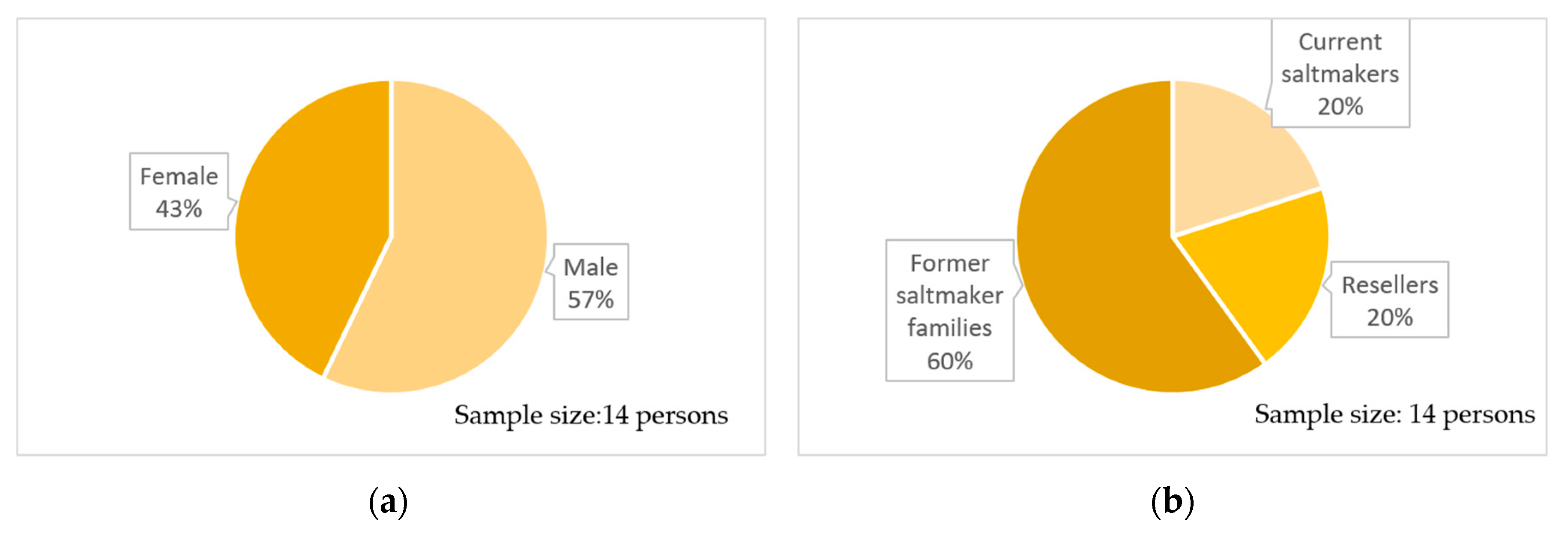
As previously mentioned, the same sampling group that was part of the previous research will be used in this one. Yet, a different dataset extracted from the result will be used in this part of the research with additional data obtained from the secondary analyses conducted in the space. The original sampling conducted in this study is based on 17 people with a relationship with the black salt industry. They are divided into those who have maintained or had a direct relationship. This group is divided by gender, resulting in seven men and ten women. Due to the initial lack of information on the subject, it was decided to use the snowball approach, which helped increase the group of correspondents in the main interview. The snowball approach comprises asking a starting sample group for more people with knowledge of the subject of the research. This “snowballs” into more and more people while retaining the same level of relationship to the research question [
36]. This results in two surveys (one conducted in the first phase, or the “pilot survey”, and a second one in the second phase, or the “main survey”), with a noticeable difference in size. The pilot survey resulted in four correspondents. Meanwhile, the main survey correspondents increased in number up to 11, shown in
Table 2.
Figure 16 shows the total division of gender between both surveys conducted. The name for the subjects is the “Main survey subject” (MSS).
2.1.2. Salt Kitchen Measurements and Area Location
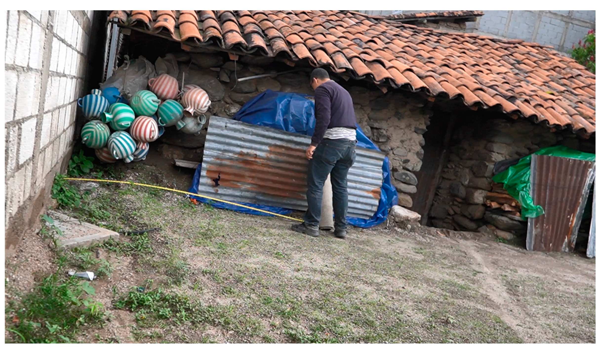
Analyzing all the data obtained from past research, it was concluded that information related to salt kitchens and their architecture has been extremely scarce. The only data found by Monaghan and Reina are relatively general and function as a description of the area rather than an architectural analysis. It was decided to obtain, catalog, and digitize the architectural information of the salt kitchens, inside and outside of them. The process involved the researcher, his assistant, and the owner of the salt kitchen. Obtaining the information comprised mostly a site visit to the MSS-A salt kitchen, where the measurements of the external and internal elements were identified. It was initially expected to analyze the three kitchens that are still being used. Yet, due to the privacy of rural Mayan communities and the researcher being an outsider, only one of the salt makers (MSS-A) agreed to this. Though according to MSS-A, the construction and space elements are the same in every one of the kitchens. This analysis was conducted with a research assistant, and took place during the wet season; thus, there was no inconvenience in disturbing the daily salt cooking of MSS-A.
After understanding the general aspects of the architecture, the research was expanded to the surrounding areas to find their whereabouts. Based on the information previously obtained in the interviews, the information collected in both the interviews was used as a basis to find the ruins of the salt kitchens. A subsequent field survey of the area near the salt beach was conducted. The objective was to understand the terrain and find if there was any relation between their distribution on the salt beach, between each salt kitchen, and the current usage of the spaces where salt kitchens were built.
2.2. Methodology
2.2.1. Interview
The first pilot survey was conducted over one month due to the location and availability of the people involved. The goal of this survey was to understand the actual situation of the beach, how many people are still working in the black salt industry, and what kind of information can be obtained from the interviewees. As mentioned before, a snowball approach was initially used to help achieve these goals, which helped further deepen the understanding of the black salt beach in the main survey. In total, it resulted in 4 h of conversation. There were several challenges in gathering information due to the area’s location and respondents’ age. To overcome this issue, questions were reinterpreted in the second survey and a temporary stay was conducted in the town. The questionnaire used is presented in
Appendix B.
During the pilot survey, the information obtained was analyzed line by line using microanalysis and separated using the methodology employed by Kambaru [
37]. For this purpose, all the answers obtained in the interviews were transcribed verbatim. Then, each of the responses was analyzed to find similar patterns. This resulted in “information groups” that present the same meanings that relate to similar concepts which are depicted in
Table 3. These groups will be referred as “information clusters” and the aim of this method is to reach “theoretical saturation”. This means that once enough information is obtained from any of these clusters, the concept is considered to have reached “theoretical saturation” and no more information is needed to be gathered. The “Theoretical saturation” is a limit that has to be decided by the researcher, though. In the case of the pilot survey, there is no prior knowledge of which information clusters will be made. The only information gathered was from the literature research available at the moment, and even then, it has been mentioned that the amount of information on black salt is still scarce on topics outside the salt industry. Therefore, saturation was considered when the information gathered was similar to the previous literature research. As such, only the “Process” information cluster was too well researched that new information was null. In total, 10 information clusters were identified, ranging from the relation of the black salt industry with the interviewee, to the influence of black salt beyond the town of Sacapulas (such as clusters “Religion” and “Trade”). An example of the microanalysis tool can be found in
Appendix C.
During the main survey, the results were analyzed in the same way as in the pilot survey. In total, the main dataset comprised 171 new entries divided into 13 information clusters, and 3 of the new information clusters were identified by recurring mentions in the interviews conducted. Their importance was also noted to the relevancy of the investigation effort conducted in the area. Thanks to the pilot survey, it was understood what information was necessary to deepen and obtain about the different clusters previously identified. For this, the main survey consisted of pinpoint questions that sought to deepen the understanding and successfully reach a logical conclusion or perspective. This is the “theoretical saturation” that was considered. After the microanalysis conducted on the information, 12 of the 13 reached “theoretical saturation”. The only one that could not reach this point was “authorities”, which is a cluster focused on the intervention of local authorities to manage the salt beach. At the point of developing this research, communication with the authorities has been unsuccessful. The summary of the new information is found in
Table 4. Due to the nature and objectives of this research, only the relevant information clusters will be used in the analysis and discussion. As mentioned before, the nature of this research paper focuses on a specific topic matter; thus, only a part of the dataset is relevant and will be employed. The first research paper made about the subject used “Terrain”, “Usage”, “Religion”, and “Ownership” clusters in the research process. This leaves 9 information clusters that could be triangulated with new information about different aspects of the subject matter. In this paper, it was decided to use the information recapitulated in the “Architecture,” “Process”, “Problem,” and “Diversification” clusters.
The objective of this research paper is to fully understand the situation of the salt kitchens and its relation to the salt beach. Therefore, the cluster “Architecture” was selected due to it containing all the relevant information about the salt kitchens not previously mentioned by other research. At this point, the information gathered on this cluster mainly comprises the known location of the active salt beaches and the known location of previous salt kitchens (currently destroyed salt kitchens). “Process” was also selected due to the analysis of the overall function of the kitchen. This helped understand how the architecture works towards the end goal of salt cooking, and a further analysis was made with the secondary analysis conducted. “Problem” and “Diversification” are clusters that present both the issues that the salt industry is facing, and what the response by salt maker families to this phenomenon is. Specially, how it affected the cultural expressions that this research is interested on. All of this information was eventually triangulated with the information from the secondary analysis performed in the area, giving a bigger and more complete outlook and analysis.
2.2.2. Architecture Measurements and Planimetry
In this research, we chose to analyze in detail the measurement of the black salt kitchens. This type of work has yet to be conducted in detail before, the mention of it by Reyna and Monaghan being the only available data on the subject. This has resulted in a lack of critical information of certain aspects about the process: What is the main tool used for salt cooking, what are its dimensions, and what is its overall function? Specifically, the information obtained in this analysis comes from the viewpoint of an architect. Therefore, the information obtained corresponds to the following: construction elements used, architectural elements, and spatial measurements inside and outside the architectural elements. After that, the data were entered into the Revit 2023 architectural modeling program, where the architecture’s views, plans, sections, and general details were created. The usage of this program was due to its convenience and easiness to complete the task at hand, and because it presents the results not only in 2D (planimetry), but also in 3D (visualization of the overall building). The results can be found in
Appendix A with a detailed analysis of its features and spatial use in
Section 3.1 and
Section 3.1.1.
2.2.3. On-Site Architecture Localization
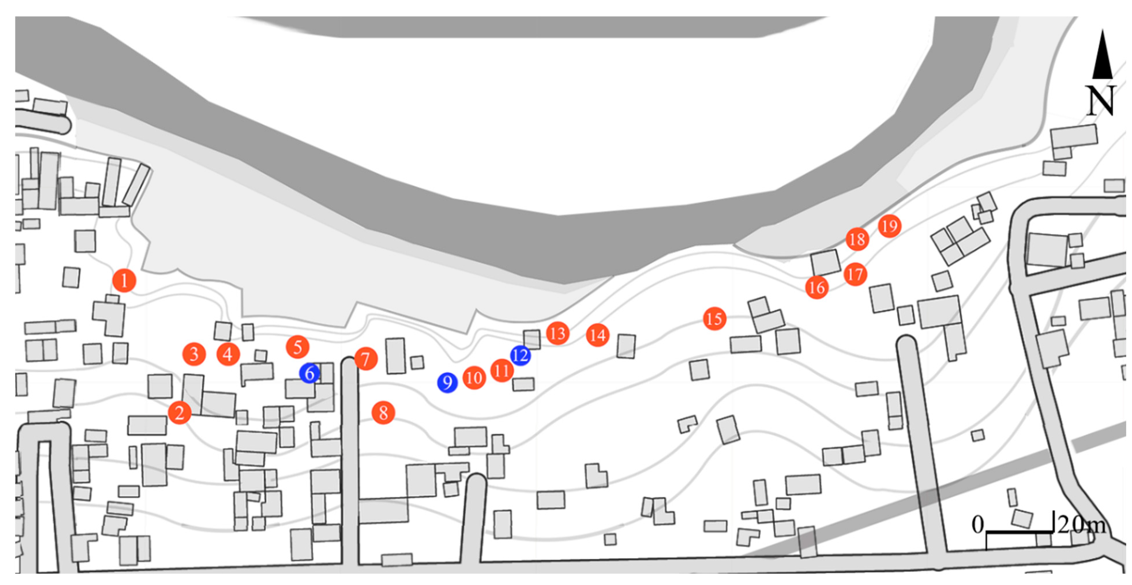
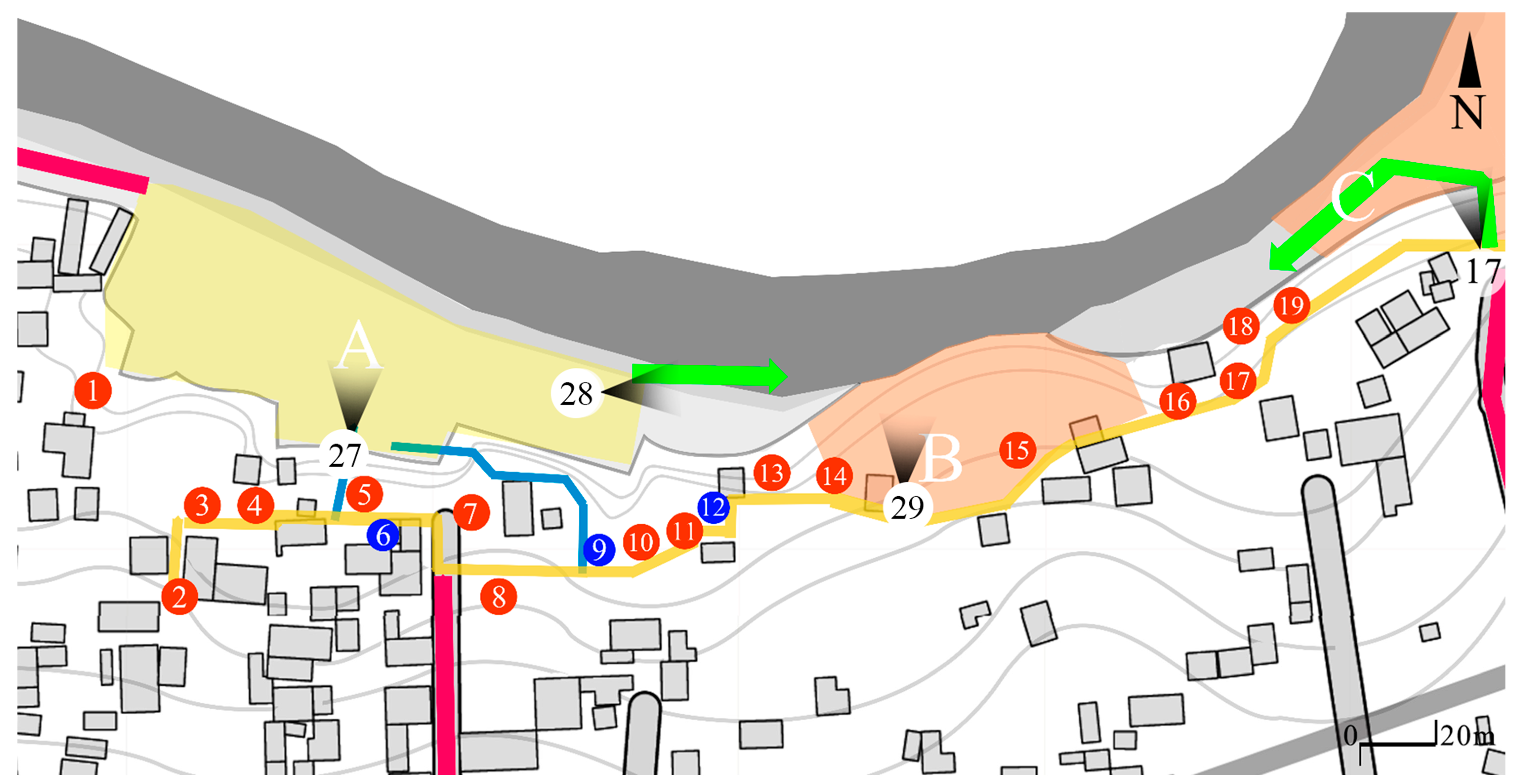
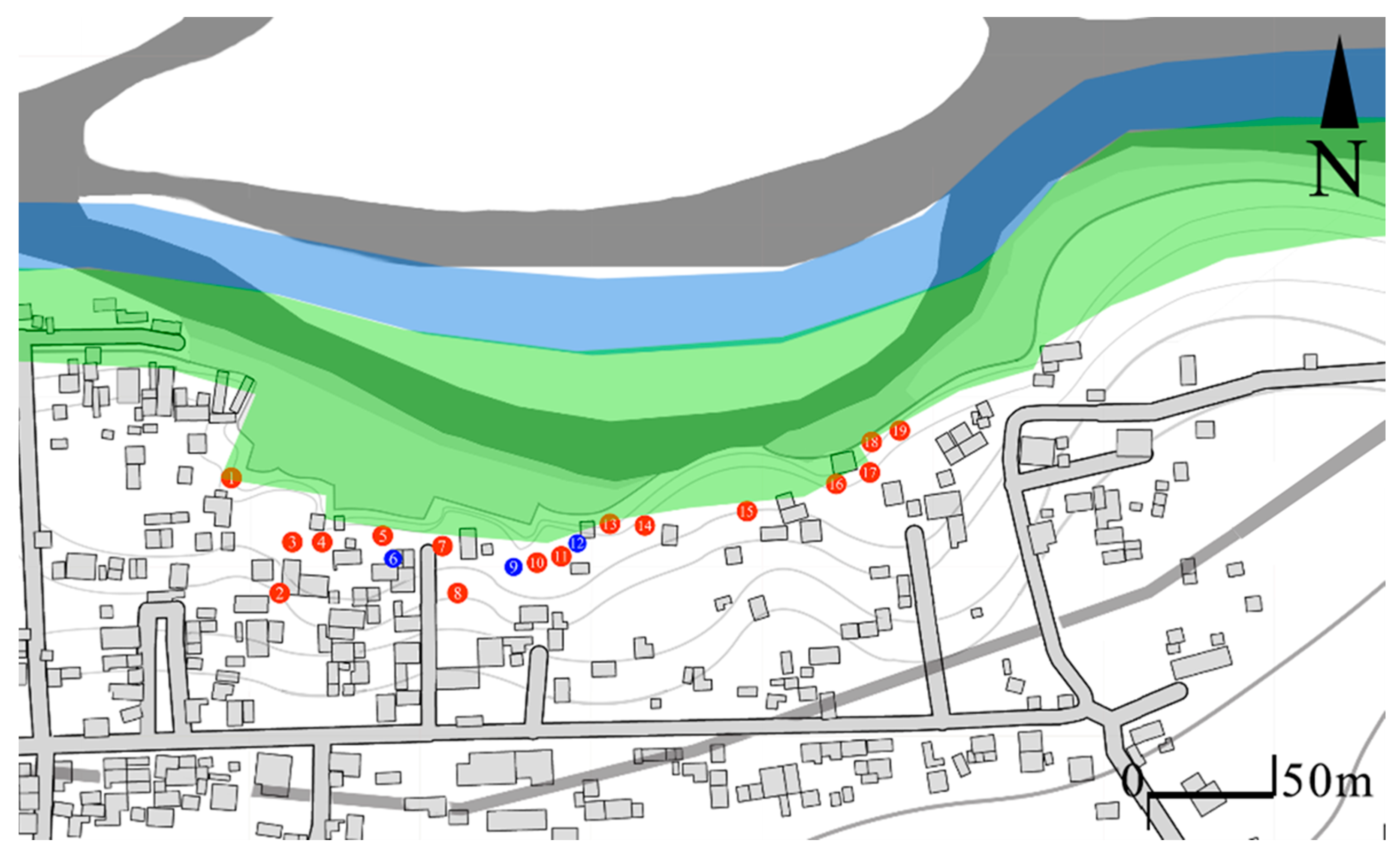
Analyzing the location of each salt kitchen, two essential things could be determined. First, there is no record of the locations of any salt kitchens; only the knowledge of the former salt makers provides a general idea of their location. Second, a record of the salt kitchens currently in use is needed. Since this information has not yet been developed, it is not easy to understand the current state of the black salt industry. By obtaining the location of salt kitchens and the spaces where they existed, it is possible to understand their relationship to the salt beach, which would help define the shape of the beach before the floods buried the majority of it. Two sets of information were used at this stage:
The result of the field visit was the location of fifteen areas where salt kitchens were built and three existing ones in use. Due to privacy concerns, some of the space owners did not share information other than the location of the salt kitchen. Meanwhile, other locations were found run over with vegetation. A summary of these data is presented in
Table 5. By knowing the location, it was then pinned in a GPS and mapped in Google Maps, resulting in a semblance of an orderly distribution across the area. With these results, it can be much better understood if there is a relationship between the space, the kitchens, and the salt beach. The locations of all the elements found is represented in
Figure 18 while a discussion is conducted in
Section 3.2.
There is some difference in the number of salt kitchens found compared to the information obtained in the existing literature and the interviews conducted with the people involved. According to MSS-A, the number of salt kitchens in 1970 was around 44. However, it was mentioned that, due to the earthquake in 1976, most of the salt kitchens were destroyed due to their structural composition. Of the mentioned salt kitchens, at this moment it is hard to know their location due to the loss of the collective memory. However, the 19 found present a particular distribution and relationship with the beach space, which clarifies how they interacted with the beach to some extent.
Figure 19,
Figure 20 and
Figure 21 depict the last salt kitchens standing.
5. Conclusions
By taking into account the research conducted since Andrews and the latest researchers, it is understood that the local salt industry is effectively dying. As discussed in
Section 1, Andrews mentioned certain causes that will eventually lead to the loss of the black salt. This and the previous research conducted on the subject have confirmed it to be true, and also identified new reasons that have accelerated this loss. As a consequence of the industry dying, cultural expressions such as the architecture have also been affected. Black salt is a product with close ties to the people of Sacapulas. This has been evidenced by how the black salt beach has influenced the architecture, town, and urban fabric. In addition, Maya texts and chronicles present an era when the native people of Sacapulas celebrated their roots and black salt work in religious demonstrations [
31], evidence of the importance of the space. Today, this is different; the celebrations are no longer held and a part of the culture has effectively died. However, a specific group of people still practice this profession. By developing this research, a documented account of the architecture has been successfully completed. Now, several new steps must be taken to properly understand to what extent the salt beach space and industry can be recovered. How we can adapt such traditional methods to make them economically feasible, or at least interesting enough for the people, is an important point to discuss. Plenty of research has yet to be conducted in the area, which could yield a better understanding of the current intangible value it presents to the people of Sacapulas. By developing the current research, it was found that people outside of the salt industry still use the beach, even knowing that the space presents an actual danger. A first step should be to understand what the usage and frequency of the salt beach are, and what activities are currently conducted in the space. This research will yield the necessary information to decide what the best direction to recover the space is, and the feasibility of such action. Information about the usage outside of the salt industry does not exist yet, and no research conducted up to this point has ever been interested in activities other than the salt creation. There is an important need due to such historical lack of information, and prompt action is required.
After understanding its current usage, future research may focus on two aspects: the black salt product, and the recovering of the salt beach. As discussed previously, one of the most attractive reasons for the black salt is the medicinal properties attributed to it, which have yet to be proved by research. This goes beyond the expertise of this researcher, yet the subject might prove attractive to researchers interested in Mayan culture who desire its safeguarding. Meanwhile, this research has hypothesized the original shape of the black salt beach due to the relation between known architecture elements, urban thread, and the current black salt beach. This should be further researched as research and locals suggest that more salt beaches existed beyond the ones found. It is also noted that soil analysis should be conducted around the hypothesized area to understand if, in effect, the flooded area presents similar properties as the current salt beach. Beyond this, the most important decision is the call for action. The benefits of such work go beyond saving a culturally important product; it impacts the livelihood of people living in constant danger. All the research conducted in the area has mentioned this, and yet there has been a holistic approach towards danger reduction. By managing, planning, and executing, the region of Sacapulas can capitalize on the natural resources that the salt beach has given to them for a long time. And by saving part of the black salt industry, an opportunity for cultural celebration will be possible for the Guatemalan people. A proper plan to safeguard in any way the culture of the area while also helping the community can be conducted in many ways, yet the economic feasibility of said action will shape decision making. Implementing KIPS for an auto-sustainable approach, recovering the “costumbre”, and cataloguing and creating urban and architectural planimetry all help raise awareness and will eventually revitalize the black salt beach.
Regardless of the final outcome, decisions are being made right now. And hopefully in the future, both the town of Sacapulas and the black salt can become an attractive and important part of Guatemala, as they were long ago.


