1. Context
The impact of natural hazards on lives and economy are of prime importance to society, especially for developing countries, where mortality is disproportionately high and material losses can have a catastrophic impact on economies. The roadmap to reduce these impacts is laid out in the Sendai Framework for Disaster Risk Reduction 2015–2030 (Sendai Framework). The aim of this initiative is to reduce the number of affected people and disaster-induced casualties, minimize direct economic loss, and reduce disaster damage to critical infrastructure and basic services. The broader thematic framework of the United Nations (UN) 2030 Agenda for Sustainable Development with its 17 Sustainable Development Goals (SDGs) also recognizes the opportunities to achieve SDGs through reducing disaster risk. Finally, the Paris Agreement within the United Nations Framework Convention on Climate Change (UNFCCC), as the third pillar of the global policy framework, stresses the importance of having a risk assessment and management strategy and the need of reducing risks related to climate change.
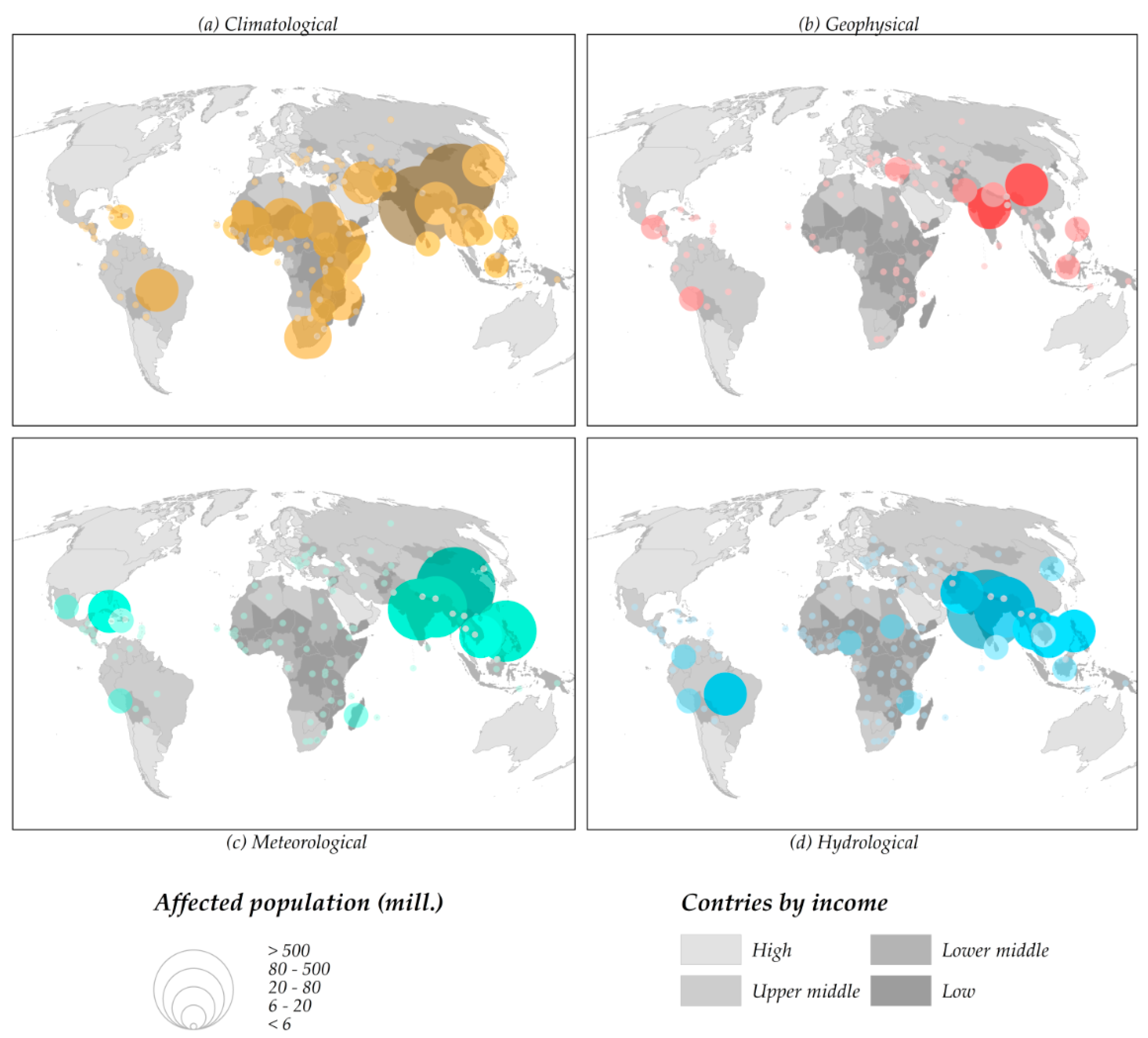
According to the World Bank (WB), over the past 30 years, more than 2.5 million people have been lost due to natural disasters and 410 million deaths are expected due to flood events by 2025, only for East Asia and the Pacific region [
1]. Moreover, economic losses had reached almost US
$4 trillion by 2011 [
2] and events occurred during 2017 accounted for economic losses of about US
$337 billion. A reflection of the typically most devastating events worldwide is shown in
Figure 1: hurricanes in the Caribbean; tropical storms and severe rains in the Philippines and Zimbabwe; earthquakes in Mexico and Iran/Iraq; floods in India, Sierra Leone, Colombia, Sri Lanka, Peru, and Nepal; snowstorms in Afghanistan and Pakistan; heatwaves in India and landslides in Congo and Bangladesh. The number of people affected by disasters since 1900 and excluding high-income economies, is highest in East Asia (especially China, Philippines, Indonesia, Vietnam, and Thailand); South Asia (India); America (Mexico, Central America, and Colombia), and Africa (Sahel area affected by droughts) [
3]. The historical distribution of events and associated impacts on population and assets provide a starting basis for implementing disaster risk reduction efforts.
2. The Setup: Disaster Risk Reduction for Sustainable Development
Development cooperation is increasingly demanding earth observation (EO) and geo-information enabling technologies for addressing the challenge of reducing disaster risk in the context of sustainable development. Disaster risk management (DRM) combines many facets such as response, recovery, rehabilitation, and reconstruction, alongside prevention, preparedness, and early warning.
There are several examples where satellite EO has been contributing to rapid response and recovery. Up-to-date reference maps and damage delineation are examples of the first case, recovery works monitoring of the latter. Terms like satellite-based emergency mapping (SEM) [
4] or rapid risk and recovery mapping are commonly used among the EO community. Different EO based capabilities for disaster response are in place, such as the International Charter Space and Major Disasters (
https://disasterscharter.org/), Sentinel Asia (
https://sentinel.tksc.jaxa.jp/), and the Copernicus Emergency Management Service (EMS,
https://emergency.copernicus.eu/).
Until the present day, the main focus of EO data within the development cooperation community has been on exposure information related to assets (risks and vulnerability to hazards), leaving unutilized or under developed an additional portfolio of EO applications [
4] (particularly risk prevention and preparedness oriented). Therefore, a broader approach to address disaster risk reduction (DRR) issues is required and the EO community is looking at both disaster risk response and mitigation [
5]. For instance, in the International Forum on Satellite EO and Geohazards [
6], an important part of the discussions about the community objectives were about EO applications for hazard identification, quantification and monitoring for prevention, preparedness, emergency response as well as post-emergency and recovery activities and mitigation strategies. The common steps were identified: identification of the sites posing a possible risk, mapping and assessing the hazard, identifying people and infrastructure, and monitoring hazards. Complementary to disaster response and recovery, risk prevention and preparedness look at DRM issues outside an emergency basis. Different actors in the domain of official development assistance (ODA) and the International Financial Institutions (IFI) are increasingly supporting initiatives to better understand hazards and mitigate risks, considering these different phases of DRM.
The United Nations Office for Disaster Risk Reduction (UNISDR) considers that “disaster risk reduction includes disciplines like disaster management, disaster mitigation and disaster preparedness, but is also part of sustainable development” [
7]. The United Nations Development Programme (UNDP) states that every dollar invested in the reduction of vulnerability of population to disasters saves around seven dollars in economic losses [
8]. The Directorate-General for Humanitarian Aid and Civil Protection (ECHO) of the European Commission indicated that every dollar invested in resilience saves between four and seven in response [
9]. The Addis Ababa Action Agenda [
10], a global framework for financing development post-2017, promotes the support to national and local capacity for the application of prevention, adaptation, and mitigation measures. The United Nations Sustainable Development Goals recognize expressly the urgent need to reduce the risk of disasters [
11].
Consequently, the development cooperation community is integrating the concept of DRR in their operational approaches. The Sendai Framework for DRR asserts that the state has the primary responsibility to reduce disaster risk, which “should be shared with other stakeholders including local governments and the private sector between others” [
12]. It sets a group of 38 indicators and four priorities for action with the aim of measuring global progress in its implementation, some of which can be addressed through EO applications. In order to illustrate this, initiatives such as UN-SPIDER Technical Advisory Missions, offer intervention at the policy and coordination level. It has action in countries like Sri Lanka, Vietnam, and Bhutan, and addresses EO applications for landslide hazard mapping between others.
3. The Concept: From Satellite Data to Actionable Information
From the supply side, EO specialists of the geospatial information community are promoting an integrated and applied perspective in disaster risk applications [
13]. From the demand side, stakeholders and actors are requiring standardized products and services for risk assessment according to the first priority of the Sendai Framework of understanding risks [
14] and users are demanding
actionable risk information [
15] in an accessible, credible, and useful format. The ultimate goal of this approach is to allow stakeholders and actors to identify and characterize natural hazards and exposure of people, assets, livelihoods, and ecosystems to these hazards, determine vulnerabilities, and support mitigation measures with location-specific information. Initiatives such as the Integrated Food Security Phase Classification, a landmark in the fight against food insecurity, base part of its recommendations on remote sensing information. Moreover, many widely accepted international initiatives for decision-making rely some of their guiding principles and recommendations on EO products (Organisation for Economic Co-operation and Development, The Council for Scientific and Industrial Research, etc.).
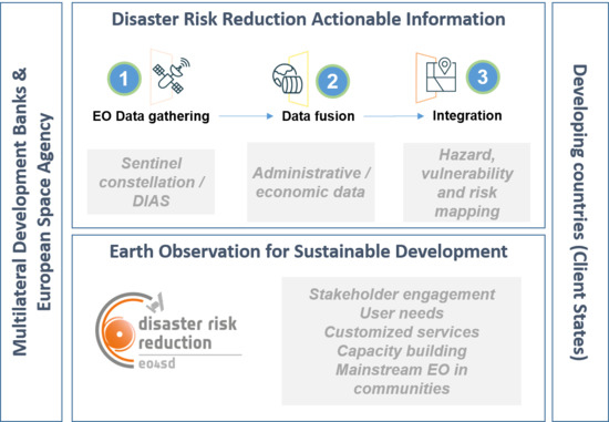
One of the challenges for EO service providers in response to these newly identified requirements is to measure the exposure of social, economic, and environmental assets to disasters. These databases of exposure (e.g., economic valuation of the territory from land use maps; day/night distribution of population in cities; building characteristics to analyze earthquake event impact) are then integrated with hazard and vulnerability data to produce actionable risk information for the end-users. The application of this concept, called DRR Actionable Information, is the basis for achieving the objective of reducing risk by the use of earth observation, and it is considered necessary to convert raw EO-borne data in continuous, global, and credible geo-information.
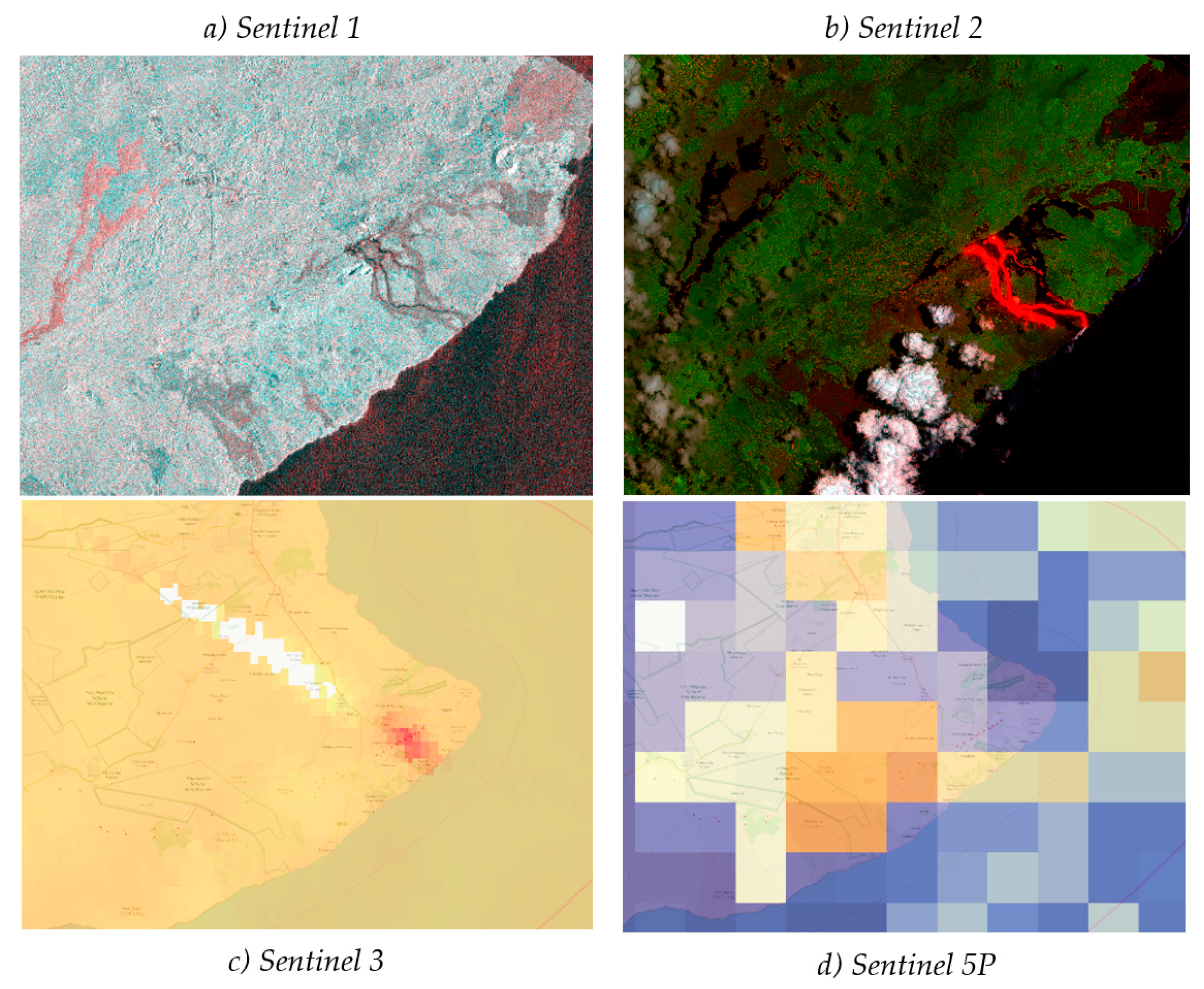
In this sense, the availability of satellite data ‘as and when needed’ is one of the key aspects in the provision of DRR actionable information. The current increase in availability and accessibility of EO mission data via cloud platforms allowing quick and efficient access (e.g., Copernicus Data and Information Access Services [DIAS]) [
15], can therefore have decisive impact in DRR. Thus, open data from the European Space Agency’s (ESA) Sentinel missions (especially Sentinel 1 and Sentinel 2) change the model of commercial, very high-resolution satellite imagery traditionally serving as the main and often exclusive source of useful EO data for DRR, to offering free of charge and easily accessible EO data. This acquires a special significance when it comes to the international community under developing circumstances. Sentinel satellites observe all global landmass every 5 days at 10 m resolution and the resulting imagery is provided under the Copernicus program’s free and open data policy, as shown in
Figure 2. Copernicus ensures a continuous and long-term guaranteed source of valid data for operational use. Sentinel data allows for the developing of new information products, improving the spatial and temporal resolution of existing products, or merging it with other data sources. In addition, countries targeted in this initiative generally face cloud cover problems at the time of the disaster occurrence making optical imagery data unusable. For these cases, considering sources as Sentinel’s 1 Synthetic Aperture Radar (SAR) instrument becomes of utmost importance.
4. The Initiative: Earth Observation for Sustainable Development
Within the global EO community, public and, increasingly, private entities are committed to supporting key global development policy frameworks. In the disaster response area, Europe takes a leading role with the Emergency Mapping Services (EMS) of the Copernicus program implemented operationally since 2012 by the European Commission and through Europe’s contribution to the International Charter Space and Major Disasters. Beyond emergency response, disaster risks are addressed in a more comprehensive manner in the context of sustainable development initiatives concerning understanding and managing risks. In addition, Copernicus EMS provides large amounts of information for DRR, becoming a very valuable resource likewise for end-users in this field. Looking at international collaborations about satellite EO and DRR, both the Group on Earth Observation (GEO) and the Committee of Earth Observing Satellites (CEOS) are supporting a range of initiatives such as the Geohazards Supersites and Natural Laboratories, the GEODARMA initiative, the GEO EO4SDG, and the CEOS Working Group Disasters.
The European Space Agency (ESA) is a contributor to both GEO and CEOS. It is collaborating with global development bodies (UN, IFI, etc.) and runs initiatives to demonstrate the value of satellite environmental information for sustainable development. Since 2008, ESA initiated and is now scaling up a collaboration with the development cooperation community and with a primary focus on IFI. The strategic vision is to ‘transfer and mainstream satellite environmental information into Development Cooperation operations, activities & financing’ [
16]. Previously, and following a set of small-scale pilot projects in collaboration with the World Bank during 2008–2009, ESA had initiated the
eoworld (Earth Observation for Development) initiative, implemented in two phases between 2010 and 2016. Following, EO4SD (Earth Observation for Sustainable Development;
http://eo4sd.esa.int) was launched in 2016 as a new program focused on larger-scale regional demonstrations. Identified users of these initiatives are IFI, such as the World Bank, the Asian Development Bank, and other multilateral development banks as well as their client states.
Under EO4SD, ESA has launched a series of large actions based on thematic service clusters provided by the European EO service sector, which are implemented in the timeframe 2016–2021 for several application areas. Starting with an initial batch of three clusters in 2016, a second batch of a further four clusters followed in 2018, including one dedicated to disaster risk reduction (DRR). The approach of these clusters is to increase the uptake of satellite-based information by IFI, multilateral development banks and their client states with a user-driven approach and a long-term perspective with the intention of mainstreaming EO-based products and services in their work practices. To achieve it, there is the need of ensuring fit to purpose in addition to transferability and scalability.
Stakeholder engagement, one of the initial projects tasks, seeks to understand user requirements of the client states that are the beneficiaries of IFI projects by contacting and dialoguing with technical team leaders and project leaders. ESA’s long-standing partnership with IFI allows this dialogue to be fully integrated in the activity cycles of these actors of international development. Institutions related to disaster risk management provide the user requirements from the side of client states. This first identification of user needs is followed by the definition of a fit-for-purpose cluster of services that better matches the executing team’s capacities with the needs of users in terms of types of products and applicability.
Transferability of EO services requires the need to build capacity to understand the value of the services, to embed the services in their practices and, when possible, to transfer geo-information production and analytics in developing countries. Mature services mean proven and standardized methodological approaches that can be easily transferred, with a delta of customization for each provided service. Besides, horizontal transferability between client states, projects of the same or even different IFI, and from a local-regional to global level is ensured by carrying out regional demonstrations at a large geographic scale for key regions (Africa, South and East Asia, and Latin America) with a view to achieve acceptance and adoption in beneficiary countries. Finally, scalability is ensured by focusing the service supply chains on open data when possible (such as using the Sentinel missions) and generally applying data at spatial and temporal resolutions adequate for client needs.
5. The Project: EO4SD DRR, Lessons Learnt, and Future Prospects
EO4SD DRR initiative aims to promote the adoption of earth observation-based products and services mainstreamed into the working processes of IFI projects that seek to prevent or mitigate the adverse impacts of natural disasters in developing countries (including prevention, preparedness, emergency response, post-emergency and recovery activities, and mitigation strategies).
A project of three years duration was awarded to a team to which the authors take part in, led by Indra and including EO European companies (Gisat, Planetek, Argans, LuxSpace, and Nazka) and institutions (Central Institution for Meteorology and Geodynamics, ZAMG). The initial portfolio consists of the following services/products: earth observation supporting services, exposure, vulnerability and risk assessment and reconstruction monitoring, landslide analysis, earthquake hazard scenarios, subsidence monitoring, tsunami hazard modelling, flooding hazard modelling, storm surge/coastal flood analysis, drought monitoring, and wild fire analysis.
Some lessons learnt hitherto, and limitations found from the development of the first stages of the project can be extracted and exposed. Firstly, products and services are of limited utility if their scope is too wide, therefore, the project foresees a next step of customization of services in a pull approach. Thus, the objective is to reach a common understanding of the user needs and possibilities of the services offered, letting the user guide the process. This approach will lead to a personalization of the services, very different to the concept of production of general services applied to specific regions. The initial portfolio of mature services will be fine-tuned to adequately match user needs.
During the near future of the project lifetime, a selection of countries and regions will be made, and a selection of services applied to champion users based on priorities elaborated with IFI stakeholders. These demonstrations, that will take place after summer 2019, intend to prove the benefits of EO products and services to support DRR in the development cooperation community. Together with capacity building activities, the overall objective is to achieve the uptaking of the EO technology and to positively influence the communities in the long term.


