Slope Stability Assessment of the Sarcheshmeh Landslide, Northeast Iran, Investigated Using InSAR and GPS Observations


Abstract
1. Introduction
2. Data and Methodology
2.1. InSAR Analysis
2.2. GPS Analysis
3. Results
3.1. InSAR Results
3.2. GPS Results
4. Discussion
5. Conclusion
Acknowledgments
Conflict of Interest
References
- Sidle, R.C.; Ochiai, H. Landslides: Processes, Prediction, and Land Use; American Geophysical Union: Washington, DC, USA, 2006; Volume 18, p. 312. [Google Scholar]
- Landslide in Iran. Available online: http://landslide.ir (accessed on 20 December 2012).
- National Geoscience Database of Iran. Available online: http://www.ngdir.ir/landslide/LandSlideInfo.asp (accessed on 20 December 2012).
- Greif, V.; Vlcko, J. Monitoring of post-failure landslide deformation by the PS-InSAR technique at Lubietova in Central Slovakia. Environ. Earth Sci 2012, 66, 1585–1595. [Google Scholar]
- Malet, J.-P.; Maquaire, O.; Calais, E. The use of Global Positioning System techniques for the continuous monitoring of landslides: Application to the Super-Sauze earthflow (Alpes-de-Haute-Provence, France). Geomorphology 2002, 43, 33–54. [Google Scholar]
- Brückl, E.; Brunner, F.; Kraus, K. Kinematics of a deep-seated landslide derived from photogrammetric, GPS and geophysical data. Eng. Geol 2006, 88, 149–159. [Google Scholar]
- Delacourt, C.; Allemand, P.; Berthier, E.; Raucoules, D.; Casson, B.; Grandjean, P.; Pambrun, C.; Varel, E. Remote-sensing techniques for analysing landslide kinematics: A review. Bull. Soc. Geol. Fr 2007, 178, 89–100. [Google Scholar]
- Strozzi, T.; Ambrosi, C.; Raetzo, H. Interpretation of aerial photographs and satellite SAR interferometry for the inventory of landslides. Remote Sens 2013, 5, 2554–2570. [Google Scholar]
- Kimura, H.; Yamaguchi, Y. Detection of landslide areas using satellite radar interferometry. Photogramm. Eng. Remote Sensing 2000, 66, 337–344. [Google Scholar]
- Lacroix, P.; Zavala, B.; Berthier, E.; Audin, L. Supervised method of landslide inventory using panchromatic SPOT5 images and application to the earthquake-triggered landslides of Pisco (Peru, 2007, Mw8.0). Remote Sens 2013, 5, 2590–2616. [Google Scholar]
- Othman, A.A.; Gloaguen, R. River courses affected by landslides and implications for hazard assessment: A high resolution remote sensing case study in NE Iraq–W Iran. Remote Sens 2013, 5, 1024–1044. [Google Scholar]
- National Aeronautics and Space Administration. Rainfall Analysis Tools. Available online: http://disc2.nascom.nasa.gov/Giovanni/tovas/rain.GPCP.2.shtml (accessed on 11 January 2013).
- Water Science. Available online: http://waterscience.blogfa.com (accessed on 20 December 2012).
- Geological Survey of Iran. States Information. Available online: http://gsi.ir/States/Lang_en/StateId_51/Action_LastUpdate/index.html (accessed on 25 June 2011).
- Hanssen, R.F. Radar Interferometry: Data Interpretation and Error Analysis; Kluwer Academic Publishers: New York, NY, USA, 2001. [Google Scholar]
- Massonnet, D.; Feigl, K.L. Radar interferometry and its application to changes in the Earth’s surface. Rev. Geophys 1998, 36, 441–500. [Google Scholar]
- Strozzi, T.; Farina, P.; Corsini, A.; Ambrosi, C.; Thüring, M.; Zilger, J.; Wiesmann, A.; Wegmüller, U.; Werner, C. Survey and monitoring of landslide displacements by means of L-band satellite SAR interferometry. Landslides 2005, 2, 193–201. [Google Scholar]
- Tantianuparp, P.; Shi, X.; Zhang, L.; Balz, T.; Liao, M. Characterization of landslide deformations in three gorges area using multiple InSAR data stacks. Remote Sens 2013, 5, 2704–2719. [Google Scholar]
- Motagh, M.; Wetzel, H.-U.; Roessner, S.; Kaufmann, H. A TerraSAR-X InSAR study of landslides in southern Kyrgyzstan, Central Asia. Remote Sens. Lett 2013, 4, 657–666. [Google Scholar]
- Rott, H.; Scheuchl, B.; Siegel, A.; Grasemann, B. Monitoring very slow slope movements by means of SAR interferometry: A case study from a mass waste above a reservoir in the Ötztal Alps, Austria. Geophys. Res. Lett 1999, 26, 1629–1632. [Google Scholar]
- Hooper, A.; Zebker, H.; Segall, P.; Kampes, B. A new method for measuring deformation on volcanoes and other natural terrains using InSAR persistent scatterers. Geophys. Res. Lett. 2004, 31. [Google Scholar] [CrossRef]
- Hooper, A.; Segall, P.; Zebker, H. Persistent scatterer interferometric synthetic aperture radar for crustal deformation analysis, with application to Volcán Alcedo, Galápagos. J. Geophys. Res. 2007, 112. [Google Scholar] [CrossRef]
- Tofani, V.; Raspini, F.; Catani, F.; Casagli, N. Persistent Scatterer Interferometry (PSI) technique for landslide characterization and monitoring. Remote Sens 2013, 5, 1045–1065. [Google Scholar]
- Berardino, P.; Fornaro, G.; Lanari, R.; Sansosti, E. A new algorithm for surface deformation monitoring based on small baseline differential SAR interferograms. IEEE Trans. Geosci. Remote Sens 2002, 40, 2375–2383. [Google Scholar]
- Lanari, R.; Casu, F.; Manzo, M.; Zeni, G.; Berardino, P.; Manunta, M.; Pepe, A. An overview of the small baseline subset algorithm: A DInSAR technique for surface deformation analysis. Pure Appl. Geophys 2007, 164, 637–661. [Google Scholar]
- Akbari, V.; Motagh, M. Improved ground subsidence monitoring using small baseline SAR interferograms and a weighted least squares inversion algorithm. IEEE Geosci. Remote Sens. Lett 2012, 9, 437–441. [Google Scholar]
- Hofmann-Wellenhof, B.; Lichtenegger, H.; Collins, J. Global Positioning System. Theory and Practice; Springer: Wien, Austria, 1993; p. 347. [Google Scholar]
- Zhou, P.; Zhou, B.; Guo, J.; Li, D.; Ding, Z.; Feng, Y. A demonstrative GPS-aided automatic landslide monitoring system in sichuan province. J. Glob. Position. Syst 2005, 4, 184–191. [Google Scholar]
- Gili, J.A.; Corominas, J.; Rius, J. Using Global Positioning System techniques in landslide monitoring. Eng. Geol 2000, 55, 167–192. [Google Scholar]
- Squarzoni, C.; Delacourt, C.; Allemand, P. Differential single-frequency GPS monitoring of the La Valette landslide (French Alps). Eng. Geol 2005, 79, 215–229. [Google Scholar]
- Motagh, M.; Djamour, Y.; Walter, T.R.; Wetzel, H.U.; Zschau, J.; Arabi, S. Land subsidence in Mashhad Valley, northeast Iran: Results from InSAR, levelling and GPS. Geophys. J. Int 2006, 168, 518–526. [Google Scholar]
- Yin, Y.; Zheng, W.; Liu, Y.; Zhang, J.; Li, X. Integration of GPS with InSAR to monitoring of the Jiaju landslide in Sichuan, China. Landslides 2010, 7, 359–365. [Google Scholar]
- Strozzi, T.; Delaloye, R.; Kääb, A.; Ambrosi, C.; Perruchoud, E.; Wegmüller, U. Combined observations of rock mass movements using satellite SAR interferometry, differential GPS, airborne digital photogrammetry, and airborne photography interpretation. J. Geophys. Res. 2010, 115. [Google Scholar] [CrossRef]
- Kampes, B.; Hanssen, R.; Perski, Z. Radar Interferometry with Public Domain Tools. Proceedings of FRINGE, ESA ESRIN, Frascati, Italy, 1–5 December 2003; Available online: http://earth.esa.int/fringe03/proceedings/papers/22_kampes.pdf (accessed on 25 May 2013).
- Farr, T.G.; Kobrick, M. The shuttle radar topography mission. Rev. Geophys 2007, 45. [Google Scholar] [CrossRef]
- Scharroo, R.; Visser, P. Precise orbit determination and gravity field improvement for the ERS satellites. J. Geophys. Res 1998, 103, 8113–8127. [Google Scholar]
- Hooper, A. A multi-temporal InSAR method incorporating both persistent scatterer and small baseline approaches. Geophys. Res. Lett. 2008, 35. [Google Scholar] [CrossRef]
- National Geodetic Survey. GPS Orbit Data. Available online: http://www.ngs.noaa.gov/orbits/orbit_data.shtml (accessed on 30 November 2012).
- Wesche, C.; Eisen, O.; Oerter, H.; Schulte, D.; Steinhage, D. Surface topography and ice flow in the vicinity of the EDML deep-drilling site, Antarctica. J. Glaciol 2007, 53, 442–448. [Google Scholar]
- Lowry, A.R.; Hamburger, M.W.; Meertens, C.M.; Ramos, E.G. GPS monitoring of crustal deformation at Taal Volcano, Philippines. J. Volcanol. Geotherm. Res 2001, 105, 35–47. [Google Scholar]
- Hessami, K.; Nilforoushan, F.; Talbot, C.J. Active deformation within the Zagros mountains deduced from GPS measurements. J. Geol. Soc 2006, 163, 143–148. [Google Scholar]
- McClusky, S.; Balassanian, S.; Barka, A.; Demir, C.; Ergintav, S.; Georgiev, I.; Veis, G. Global Positioning System constraints on plate kinematics and dynamics in the eastern Mediterranean and Caucasus. J. Geophys. Res.-Solid Earth 2000, 105, 5695–5719. [Google Scholar]
- Langbein, J. Noise in GPS displacement measurements from Southern California and Southern Nevada. J. Geophys. Res.-Solid Earth 2008, 113. [Google Scholar] [CrossRef]
- Casu, F.; Manzo, M.; Lanari, R. A quantitative assessment of the SBAS algorithm performance for surface deformation retrieval from DInSAR data. Remote Sens. Environ 2006, 102, 195–210. [Google Scholar]
- Iran Water Resources Management Company. North Khorasan Province. Available online: http://wnkh.ir/showpage.aspx?pgid=8&ids=29&? (accessed on 11 January 2013).
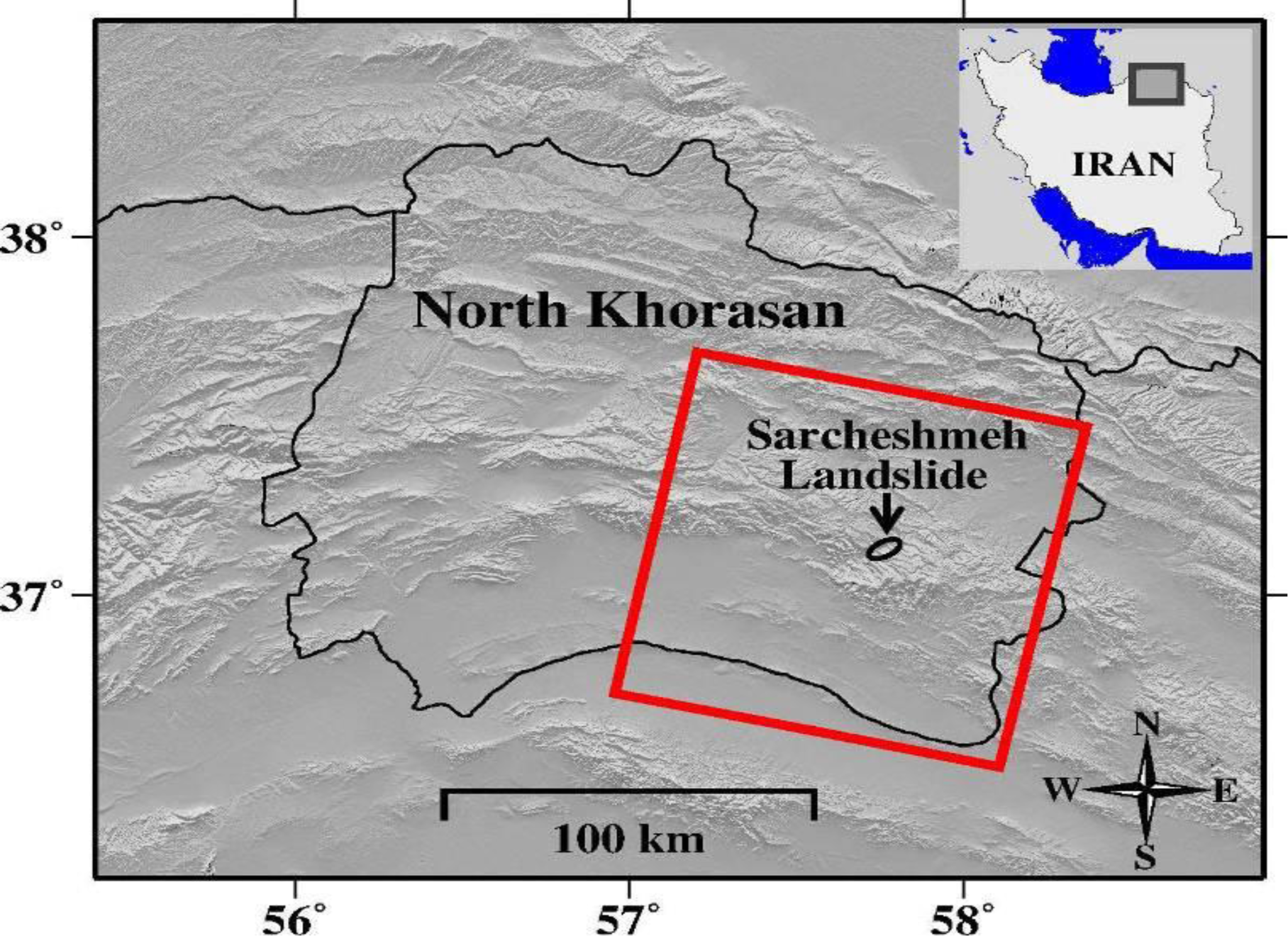
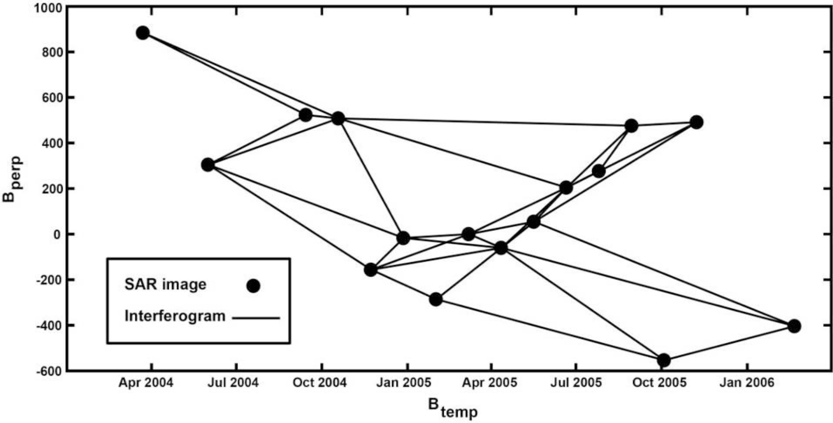
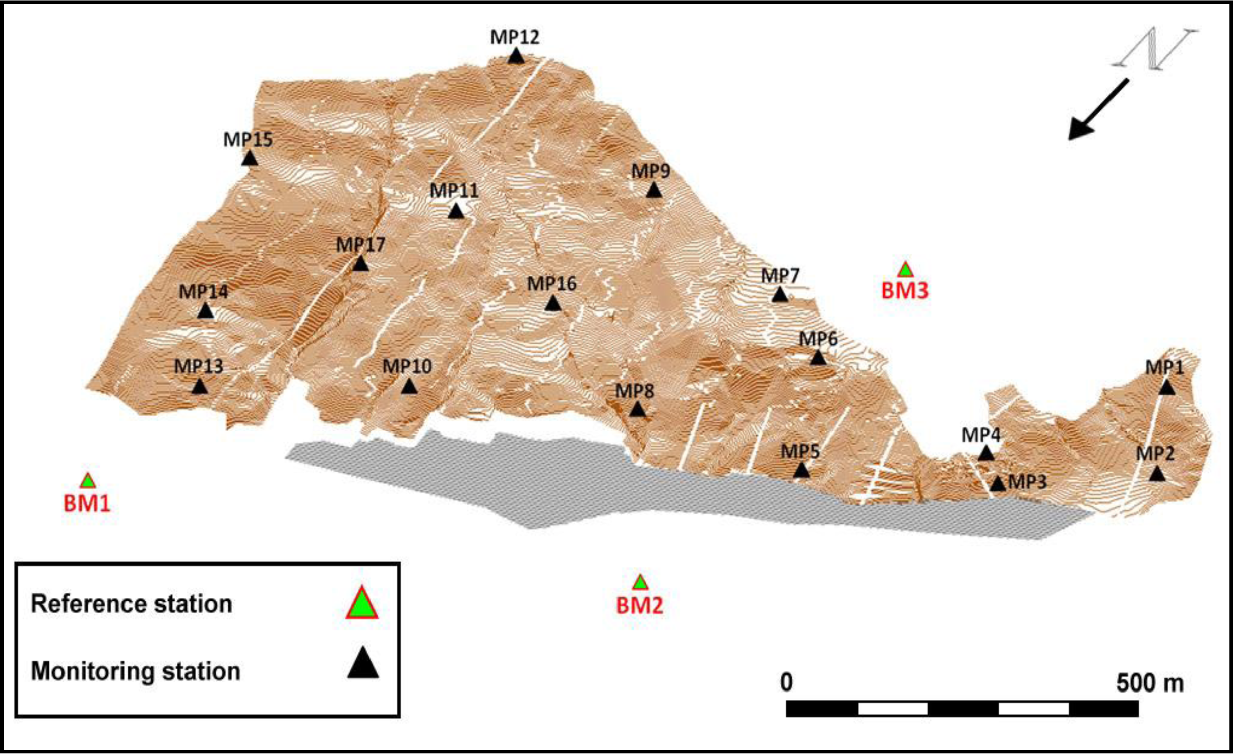

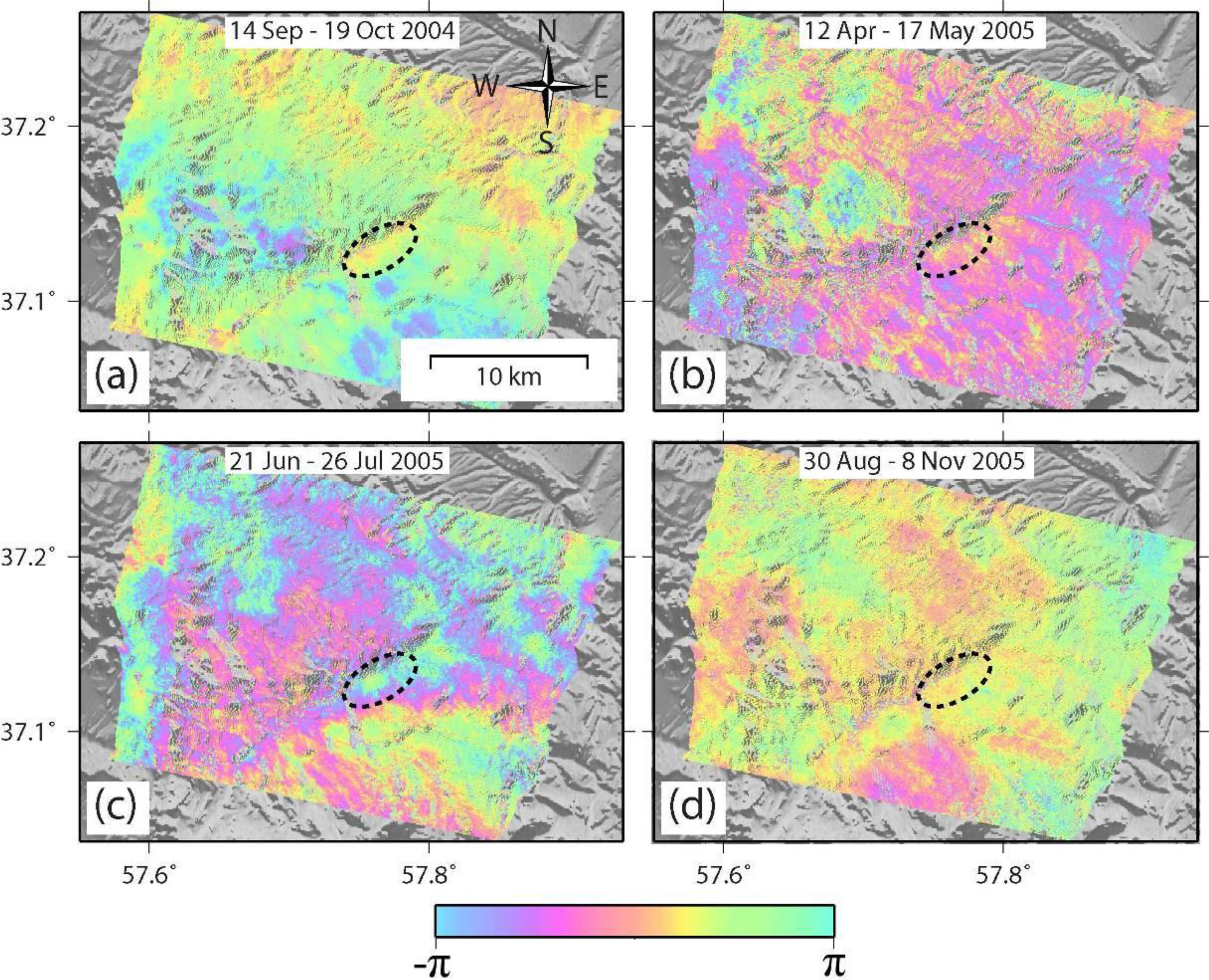
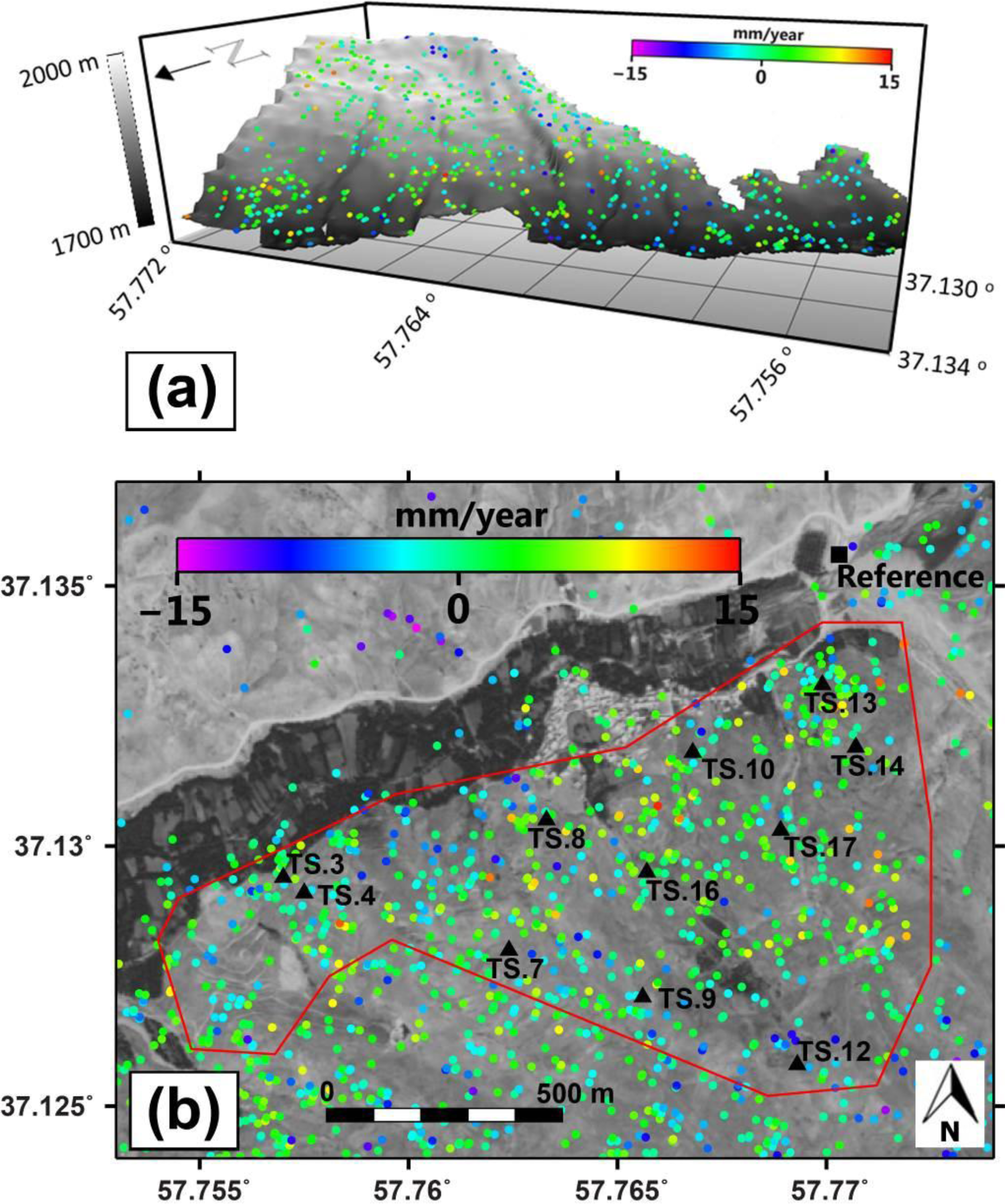

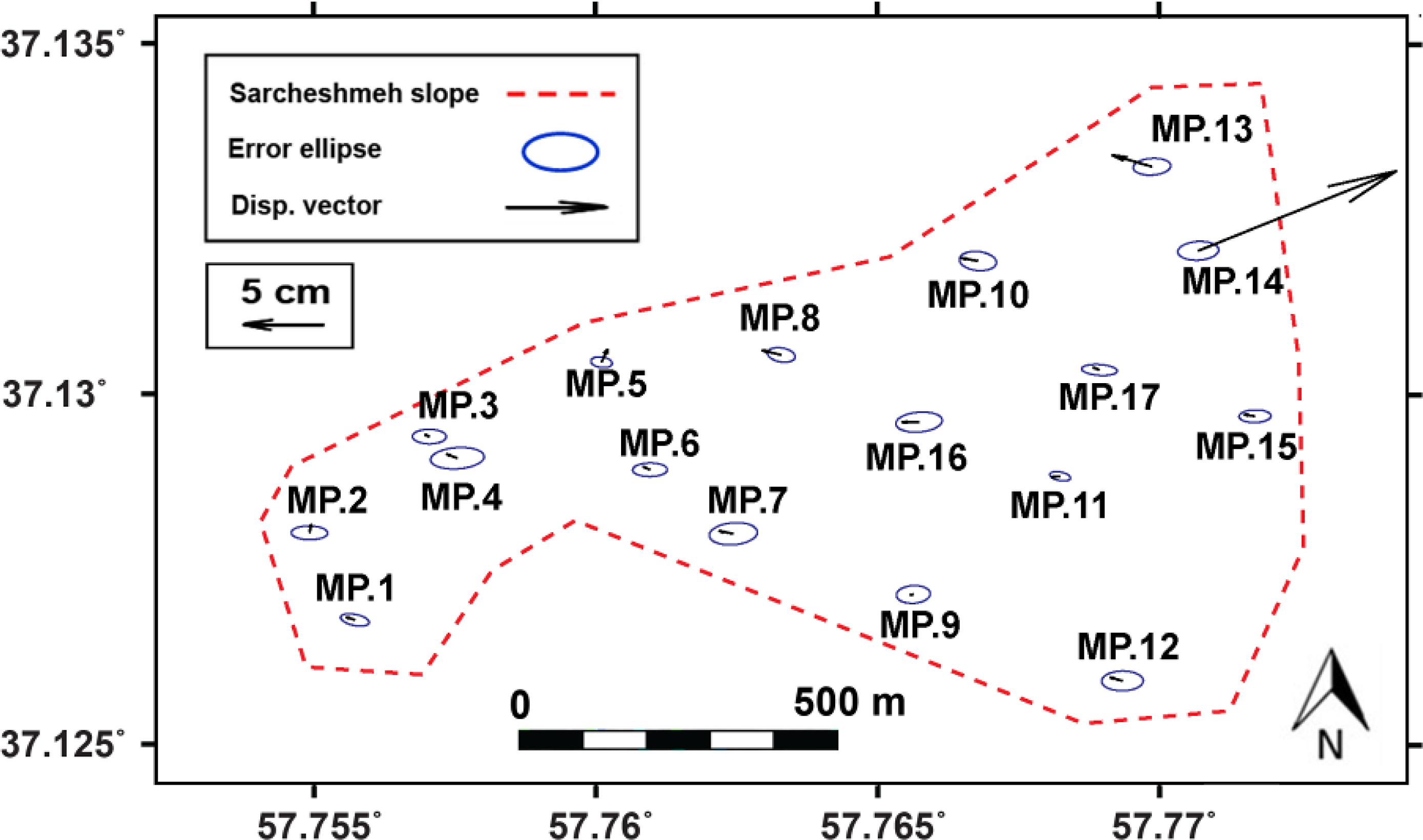
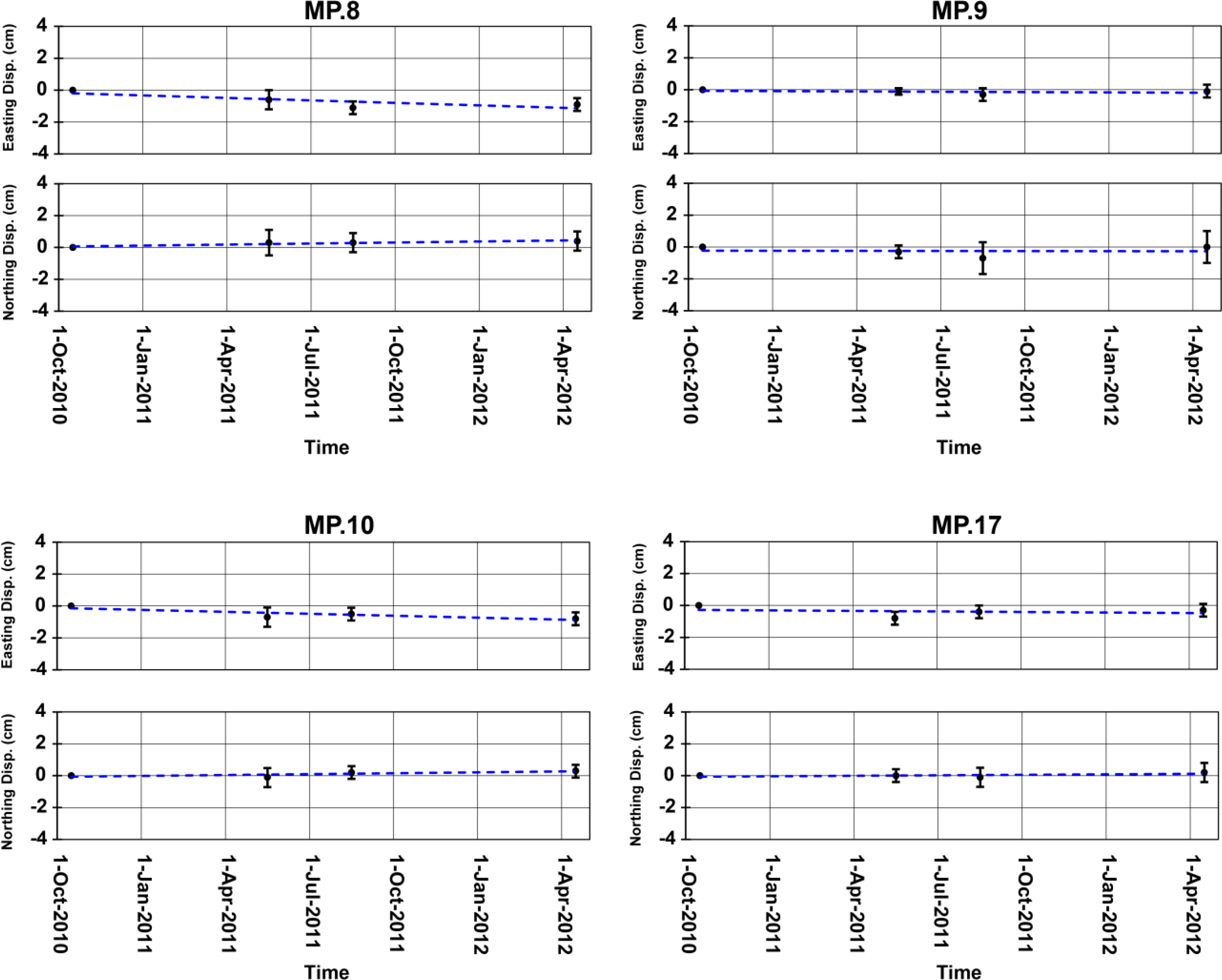
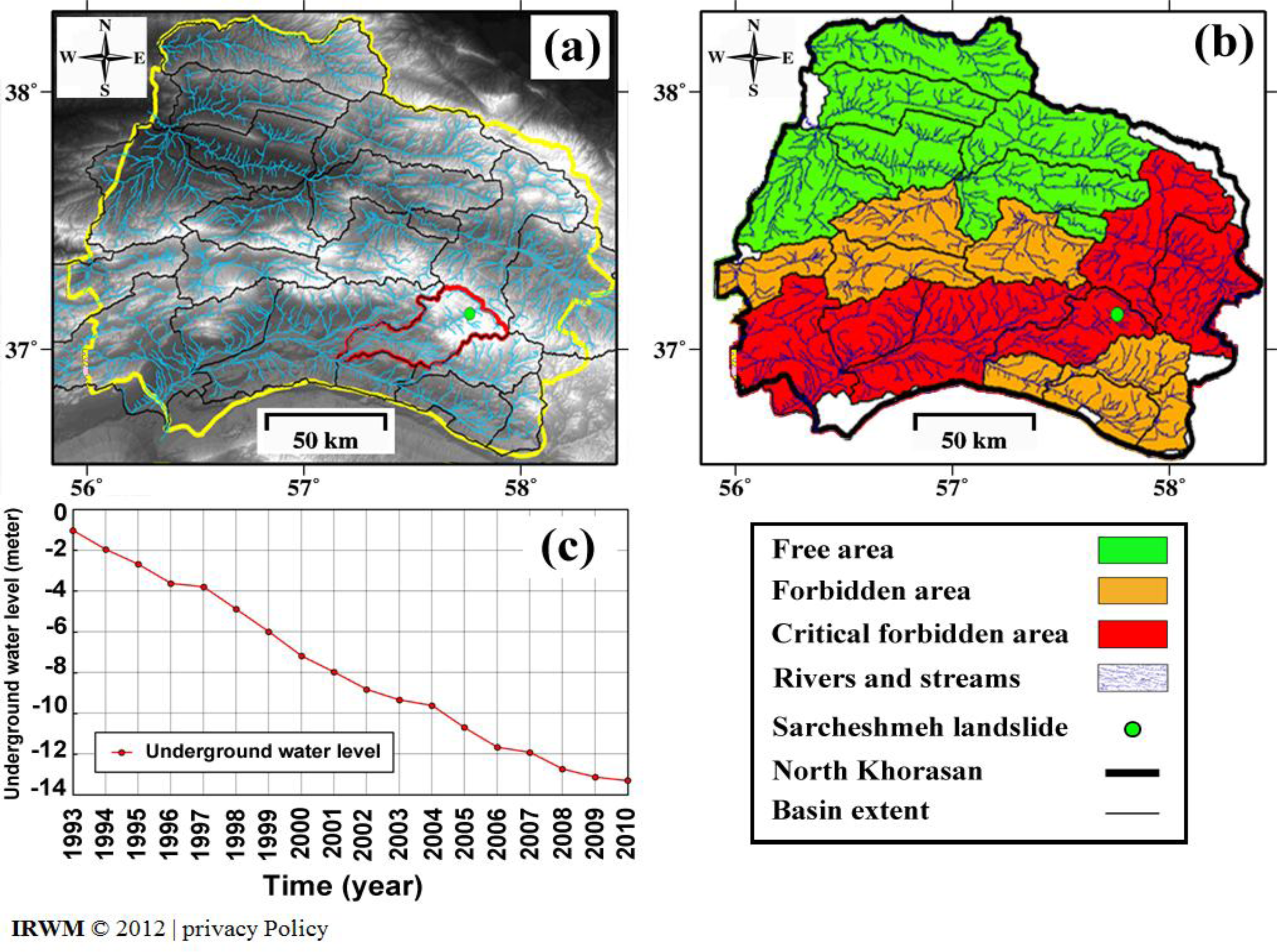

| No | Acquisition Date | Mission | Sensor | Orbit | Track | Pass |
|---|---|---|---|---|---|---|
| 1 | 2004.03.23 | Envisat | ASAR | 10781 | 206 | Descending |
| 2 | 2004.06.01 | Envisat | ASAR | 11783 | 206 | Descending |
| 3 | 2004.09.14 | Envisat | ASAR | 11783 | 206 | Descending |
| 4 | 2004.10.19 | Envisat | ASAR | 13787 | 206 | Descending |
| 5 | 2004.11.23 | Envisat | ASAR | 14288 | 206 | Descending |
| 6 | 2004.12.28 | Envisat | ASAR | 14789 | 206 | Descending |
| 7 | 2005.02.01 | Envisat | ASAR | 15290 | 206 | Descending |
| 8 | 2005.03.08 | Envisat | ASAR | 15791 | 206 | Descending |
| 9 | 2005.04.12 | Envisat | ASAR | 16292 | 206 | Descending |
| 10 | 2005.05.17 | Envisat | ASAR | 16793 | 206 | Descending |
| 11 | 2005.06.21 | Envisat | ASAR | 17294 | 206 | Descending |
| 12 | 2005.07.26 | Envisat | ASAR | 17795 | 206 | Descending |
| 13 | 2005.08.30 | Envisat | ASAR | 18296 | 206 | Descending |
| 14 | 2005.10.04 | Envisat | ASAR | 18296 | 206 | Descending |
| 15 | 2005.11.08 | Envisat | ASAR | 19298 | 206 | Descending |
| 16 | 2006.02.21 | Envisat | ASAR | 20801 | 206 | Descending |
| Point Name | Disp. Velocity (cm/year) | Standard Deviation (cm/year) |
|---|---|---|
| TS.3 | 0.1 | ±0.4 |
| TS.4 | 0.1 | ±0.4 |
| TS.7 | 0.2 | ±0.4 |
| TS.8 | 0.2 | ±0.5 |
| TS.9 | 0.0 | ±0.4 |
| TS.10 | 0.2 | ±0.4 |
| TS.12 | −0.4 | ±0.5 |
| TS.13 | 0.3 | ±0.4 |
| TS.14 | 0.2 | ±0.4 |
| TS.16 | 0.2 | ±0.4 |
| TS.17 | 0.2 | ±0.3 |
| Point Name | Epoch 1 to 2 (5 Months) | Epoch 2 to 3 (3 Months) | Epoch 3 to 4 (8 Months) | |||
|---|---|---|---|---|---|---|
| E-W (mm) | N-S (mm) | E-W (mm) | N-S (mm) | E-W (mm) | N-S (mm) | |
| BM1 | 0 ± 1 | 0 ± 1 | 0 ± 5 | 0 ± 7 | 0 ± 5 | 0 ± 8 |
| BM2 | −2 ± 2 | 0 ± 2 | 1 ± 5 | 0 ± 7 | 0 ± 5 | −1 ± 8 |
| BM3 | −6 ± 1 | −4 ± 2 | −3 ± 7 | 2 ± 9 | 4 ± 7 | −5 ± 9 |
| Point Name | Epoch 1 to 2 (5 Months) | Epoch 3 to 4 (8 Months) | Epoch 2 to 3 (3 Months) | |||
|---|---|---|---|---|---|---|
| E-W(mm) | N-S (mm) | E-W (mm) | N-S (mm) | E-W (mm) | N-S (mm) | |
| MP1 | −4 ± 4 | −2 ± 6 | −1 ± 4 | 3 ± 6 | 1 ± 4 | 2 ± 6 |
| MP2 | −1 ± 4 | 6 ± 4 | −3 ± 6 | −4 ± 6 | 4 ± 4 | 6 ± 6 |
| MP3 | −4 ± 4 | −2 ± 4 | −2 ± 12 | −3 ± 14 | 4 ± 12 | 7 ± 14 |
| MP4 | −4 ± 4 | 0 ± 4 | 2 ± 6 | 1 ± 6 | −3 ± 6 | 3 ± 8 |
| MP5 | 4 ± 4 | 12 ± 4 | −3 ± 4 | −4 ± 6 | 2 ± 4 | 4 ± 6 |
| MP6 | −3 ± 2 | 3 ± 4 | 0 ± 2 | 0 ± 4 | 0 ± 4 | 1 ± 6 |
| MP7 | −4 ± 2 | 4 ± 4 | 0 ± 4 | −4 ± 6 | −3 ± 4 | 2 ± 8 |
| MP8 | −6 ± 6 | 4 ± 8 | −5 ± 4 | −1 ± 6 | 2 ± 4 | 1 ± 6 |
| MP9 | −1 ± 2 | −3 ± 4 | −2 ± 4 | −4 ± 10 | 2 ± 4 | 7 ± 10 |
| MP10 | −7 ± 6 | −1 ± 6 | 2 ± 4 | 3 ± 4 | −3 ± 4 | 1 ± 4 |
| MP11 | −3 ± 4 | 1 ± 4 | −2 ± 4 | −1 ± 4 | 1 ± 4 | −1 ± 4 |
| MP12 | −2 ± 4 | 2 ± 4 | 0 ± 4 | −3 ± 6 | −3 ± 4 | 4 ± 6 |
| MP13 | −9 ± 2 | 6 ± 4 | −6 ± 2 | −1 ± 4 | −5 ± 2 | 6 ± 4 |
| MP14 | −4 ± 2 | 1 ± 4 | 130 ± 2 | 57 ± 4 | 25 ± 2 | 17 ± 4 |
| MP15 | −2 ± 2 | −2 ± 4 | −1 ± 4 | 2 ± 8 | −2 ± 4 | 2 ± 8 |
| MP16 | −5 ± 2 | 1 ± 6 | 2 ± 4 | 2 ± 6 | −6 ± 4 | −3 ± 4 |
| MP17 | −1 ± 4 | 0 ± 4 | −4 ± 4 | −1 ± 6 | 2 ± 4 | 4 ± 6 |
© 2013 by the authors; licensee MDPI, Basel, Switzerland This article is an open access article distributed under the terms and conditions of the Creative Commons Attribution license ( http://creativecommons.org/licenses/by/3.0/).
Share and Cite
Akbarimehr, M.; Motagh, M.; Haghshenas-Haghighi, M. Slope Stability Assessment of the Sarcheshmeh Landslide, Northeast Iran, Investigated Using InSAR and GPS Observations. Remote Sens. 2013, 5, 3681-3700. https://doi.org/10.3390/rs5083681
Akbarimehr M, Motagh M, Haghshenas-Haghighi M. Slope Stability Assessment of the Sarcheshmeh Landslide, Northeast Iran, Investigated Using InSAR and GPS Observations. Remote Sensing. 2013; 5(8):3681-3700. https://doi.org/10.3390/rs5083681
Chicago/Turabian StyleAkbarimehr, Mehrdad, Mahdi Motagh, and Mahmud Haghshenas-Haghighi. 2013. "Slope Stability Assessment of the Sarcheshmeh Landslide, Northeast Iran, Investigated Using InSAR and GPS Observations" Remote Sensing 5, no. 8: 3681-3700. https://doi.org/10.3390/rs5083681
APA StyleAkbarimehr, M., Motagh, M., & Haghshenas-Haghighi, M. (2013). Slope Stability Assessment of the Sarcheshmeh Landslide, Northeast Iran, Investigated Using InSAR and GPS Observations. Remote Sensing, 5(8), 3681-3700. https://doi.org/10.3390/rs5083681