Article

A Framework for Defining Spatially Explicit Earth Observation Requirements for a Global Agricultural Monitoring Initiative (GEOGLAM)

by
Alyssa K. Whitcraft
*,
Inbal Becker-Reshef
and
Christopher O. Justice
Department of Geographical Sciences, University of Maryland, 4321 Hartwick Rd. Suite 410, College Park, MD 20742, USA
*
Author to whom correspondence should be addressed.
Remote Sens. 2015, 7(2), 1461-1481; https://doi.org/10.3390/rs70201461
Submission received: 29 September 2014 / Accepted: 20 January 2015 / Published: 29 January 2015
(This article belongs to the Special Issue Remote Sensing in Food Production and Food Security)

Abstract

:
Global agricultural monitoring utilizes a variety of Earth observations (EO) data spanning different spectral, spatial, and temporal resolutions in order to gather information on crop area, type, condition, calendar, and yield, among other applications. Categorical requirements for space-based monitoring of major agricultural production areas have been articulated based on best practices established by the Group on Earth Observation’s (GEO) Global Agricultural Monitoring Community (GEOGLAM) of Practice, in collaboration with the Committee on Earth Observation Satellites (CEOS). We present a method to transform generalized requirements for agricultural monitoring in the context of GEOGLAM into spatially explicit (0.05°) Earth observation (EO) requirements for multiple resolutions of data. This is accomplished through the synthesis of the necessary remote sensing-based datasets concerning where (crop mask, when (growing calendar, and how frequently imagery is required (considering cloud cover impact throughout the agricultural growing season. Beyond this provision of the framework and tools necessary to articulate these requirements, investigated in depth is the requirement for reasonably clear moderate spatial resolution (10–100 m) optical data within 8 days over global within-season croplands of all sizes, a data type prioritized by GEOGLAM and CEOS. Four definitions of “reasonably clear” are investigated: 70%, 80%, 90%, or 95% clear. The revisit frequency required (RFR) for a reasonably clear view varies greatly both geographically and throughout the growing season, as well as with the threshold of acceptable clarity. The global average RFR for a 70% clear view within 8 days is 3.9–4.8 days (depending on the month), 3.0–4.1 days for 80% clear, 2.2–3.3 days for 90% clear, and 1.7–2.6 days for 95% clear. While some areas/times of year require only a single revisit (RFR = 8 days) to meet their reasonably clear requirement, generally the RFR, regardless of clarity threshold, is below to greatly below the 8 day mark, highlighting the need for moderate resolution optical satellite systems or constellations with revisit capabilities more frequent than 8 days. This analysis is providing crucial input for data acquisition planning for agricultural monitoring in the context of GEOGLAM.

Graphical Abstract

1. Introduction

The coordination of Earth observations (EO) data necessitates first the articulation of spatially explicit EO requirements for monitoring, including where [1], when [2], how frequently [3], over which spectral range, and at what spatial resolution these data are needed. In 2007, there was an attempt by those in the Group on Earth Observations Agricultural Monitoring Community of Practice (GEO Ag CoP) to describe the data necessary for operational agricultural monitoring [4], and a related effort was made to define the requirements specifically for Europe [5]. While these efforts provided a sketch of the multiple spatial and temporal scales of required data inputs for a variety of monitoring applications and illustrated the inherent complexity of such an undertaking, they needed refinement and a higher degree of specificity in order to be translatable into data acquisition requests.
In the context of the Group on Earth Observations Global Agricultural Monitoring (GEOGLAM) Initiative—a G20-mandated activity to coordinate satellite-based monitoring of global croplands [6,7]—spatially explicit requirements for agricultural monitoring are a necessary input into data acquisition planning. In 2012, the newly formed Committee on Earth Observations Satellites (CEOS) Ad Hoc Team for GEOGLAM (including members of the GEO Agricultural Community of Practice and CEOS space agency representatives) met to articulate the spatial (Table 1 [8,9], Column B), spectral (Table 1, Column C), and “cloud free” temporal resolution (Table 1, Column D) data requirements for a variety of agricultural monitoring applications or “target products” (Table 1, Columns G–M), based on their combined experiences in research and operational agricultural monitoring [8].
Table 1. The table of requirements for satellite-based Earth observations data, developed by the CEOS Ad Hoc Team for GEOGLAM [8,9]. Requirements are broken down by spatial & spectral range (Columns B&C), frequency with which reasonably cloud-free data are required (Column D), geographic extent (Columns E&F), as well as the application or target product for which the data would be used (Columns G–M). Requirements are further refined based on the field size over which acquisitions are required (Column F), or the field sizes for which a certain data type would be useful (Columns G–M). “L” refers to “Large fields” (defined as >15 ha), “M” refers to “Medium fields” (defined as 1.5–15 ha), and “S” refers to “small fields” (<1.5 ha). The symbol “x” or the word “All” indicates that these data are useful for that product’s generation for all field sizes.
ABCDEFGHIJKL M
Spatial ResolutionSpectral RangeEffective observ. Frequency (Cloud Free)ExtentField SizeTarget Products
Req#Crop MaskCrop Type Area and Growing CalendarCrop Condition IndicatorsCrop YieldCrop Biophys. VariablesEnviron. VariablesAg Practices/Cropping Systems
Coarse Resolution Sampling (>100 m)
1500–2000 mopticalDailyWall-to-WallAll X L
2100–500 moptical2 to 5 per weekCropland extentAllXXXLLXL
35–50 kmmicrowaveDailyCropland extentAll XXXX
Moderate Resolution Sampling (10 to 100 m)
410–70 mopticalMonthly (min 3 in season + 2 out of season); Required every 1–3 yearsCropland extent (if #5 = sample, else skip)AllXL/M X
510–70 moptical8 days; 1 min per 16 daysSample (pref. Cropland extent)AllXXXXXXX
610–100 mSAR8 days; 1 min per 16 daysCropland extent of persistantly cloudy and rice areasAllXXXXXXX
Fine Resolution Sampling (5 to 10 m)
75–10 mVIS NIR + SWIRMonthly (3 min in season)Cropland extentM/SM/SM/S
85–10 mVIS NIR + SWIRApprox. weekly; 5 min per seasonSampleAll M/SX XXX
95–10 mSARMonthlyCropland extent of persistantly cloudy and rice areasM/SM/SM/S M/S
Very Fine Resolution Sampling (<5 m)
10<5 mVIS NIR3 per year (2 in season + 1 out of season); Every 3 yearsCropland extent of small fieldsSSS
11<5 mVIS NIR1 to 2 per monthRefined Sample (Demo)All X X X
These agricultural monitoring applications include mapping cropped area (crop mask) and crop type area, identifying the crop calendar, monitoring crop condition, forecasting crop yield, retrieving crop biophysical variables (such as leaf area index (LAI), green area index (GAI), and fraction of absorbed photosynthetically active radiation (fAPAR); [10,11,12,13,14]), deriving environmental variables, and identifying agricultural practices and cropping systems (including burning, tillage, transplantation, and cropping intensity) [8]. In addition to the framework this provided, the table additionally referenced where the imagery was required (Table 1, Columns E&F)—extent of coverage varies, as does the field sizes for which a given spatial/spectral resolution combination is required [15,16]—as well as when the imagery was required (Table 1, Column D), with most of the requirements being for imagery during the agricultural growing season (AGS), but a few requesting data to be acquired during the non-AGS. Although the requirements detailed herein cover many agricultural areas of the Earth, they have been generated with a particular emphasis on the monitoring of major production areas.

Agricultural Monitoring: Spatial and Temporal Considerations

Due to the rapid rate of change in crop phenology and progress—beneath the weekly time step [5,17]—reasonably cloud-free imagery is generally required with greater frequency for agricultural monitoring than it is for applications that monitor more static phenomena or processes [18]. For crop yield and crop condition, for example, clear views are needed roughly weekly or at least biweekly, although even more frequent data are valuable [18,19,20,21,22]. Due to this requirement for frequently sampled data, global cropland monitoring to date has been predominately undertaken with coarse spatial resolution data (defined in the context of GEOGLAM as greater than 100 m) [23,24], with near-daily MODIS-class observations at 250–500 m and with broad spectral coverage providing the primary data source over the past decade [25,26,27,28,29,30,31,32,33,34,35,36,37,38,39]. However, analyses relying upon coarse spatial resolution data to monitor cropland dynamics are often confronted with issues of subpixel heterogeneity [16,40,41,42,43], with many small fields or highly heterogeneous landscapes having variability beneath the spatial resolution of the sensing instrument in use. While moderate spatial resolution (defined in the context of GEOGLAM as 10–100 m) has been used extensively in national scale analyses of land cover, including cropped area and crop type mapping efforts [39,44,45,46,47,48,49,50,51,52,53,54,55,56,57,58], their limited revisit frequency and/or limitations in on-board storage capacity have meant that these data have been too sparsely collected in time and often also in extent in order to be used for agricultural monitoring at broad scales across the globe [19].
The persistence of cloud cover in certain agricultural regions and during certain portions of the AGS exacerbates the sparseness of usable data [3,5]. Meanwhile, as demonstrated by Table 1, particularly Requirements #4–6, the use of moderate spatial resolution data collected at a more frequent rate is a priority growth area for analyses spanning the full extent of croplands for fields of all sizes. With the Landsat archive opening, new moderate resolution missions set to launch, and computational resources growing, global scale analyses are poised to move into the moderate resolution domain [59,60,61,62,63,64], with regional to global datasets at 30 m resolution already demonstrated [65,66,67,68,69].
The requirements established by the CEOS Ad Hoc Team for GEOGLAM (Table 1) build upon the experience of agricultural monitoring experts from around the world (For information on the full membership of those involved in the development of this requirements table and involved in the crop monitoring in the context of the GEOGLAM activity, please refer to the GEOGLAM Community of Practice webpage [9]), who stand in agreement that more frequent moderate spatial resolution imagery are required for operational cropland monitoring (beyond cropped area and crop type) than are presently freely available to and accessible by the public, particularly if more broad scale monitoring is to be undertaken. While Table 1 provides a solid conceptualization of the requirements, we present the datasets and the tools to place each of the individual requirements in its geographical, spatially explicit context with respect to target cropland locations [1], growing season calendar [2], and cloud cover considerations [3]. As an example of this process, particularly highlighted here are the requirements to yield reasonably cloud-free views within 8 days over in-season agricultural areas, as articulated by Table 1, Requirement #5. This analysis builds upon previous efforts, in particular taking the cloud cover dataset introduced in Whitcraft et al. (2015) [3] and transforming it to reveal precisely where, when, how frequently, and to what spatial extent data are required, highlighting localities and regions in which cloud cover may present a barrier to optical remote sensing. This paves the way for an analysis of the ways and regions in which we can (or cannot) meet our data requirements for agricultural monitoring (found in the subsequent manuscript by Whitcraft et al. (this issue) [70]). These requirements are an important input into satellite data acquisition planning by CEOS in the context of GEOGLAM.

2. Datasets & Methods

While the requirements established in Table 1 are explicitly for “cloud-free” data, in reality there are many cases where data that are reasonably cloud-free may be sufficient. The definition of “reasonable” will vary with application and study area, and thus the revisit frequency required for a variety of clarity thresholds are herein considered: 70%, 80%, 90%, and 95% clear, the latter considered virtually cloud-free and clear.

2.1. Input Datasets: Where to Image?

The first step in defining EO requirements for global agricultural monitoring is identifying the areas that require monitoring, namely the locations of global croplands [71]. To this end, Fritz et al. (2015) [1] have developed a “best-available” cropland mask that indicates the probability that any 0.0083° (~1 km at the Equator) cell contains cropland based on a suite of existing land cover and cropland masks. This harmonizing and synthesizing effort was undertaken in the context of GEOGLAM, and as such has been chosen as the cropland mask for this analysis. Due to the resolution of other input datasets (namely, cloud cover, Section 2.3), and balancing data volume considerations with the need for a resolution sufficiently fine to be scalable to very fine to moderate (<100 m) spatial resolution missions’ swath widths (approximately 11 km [Ikonos] to 740 km [AWiFS]), this cropland mask has been degraded to 0.05° (~5.6 km at the Equator). While different cropland probabilities are likely suited for different areas of the globe, a threshold has been set at 20% as it aligns well with understood cropland distributions [33,72].
The requirements are also broken down by the field sizes for which they are prescribed. Generally speaking, larger fields can be adequately imaged using coarser spatial resolution data, while medium fields require moderate spatial resolution data and smaller fields require finer spatial resolution data [73]. These relationships are further contingent upon shape, arrangement, fragmentation, and crop type heterogeneity of the fields as well as the imaging bandwidths [15,16], and future articulations of the requirements can be refined by the inclusion of this additional information. However, such datasets do not currently exist at the global level, and in the interim, the broad relationship between field size and necessary spatial resolution is sufficient to allocate fine, moderate, and coarse spatial resolution data acquisitions. A research group at the International Institute for Applied Systems Analysis have deployed an online collaborative tool called “GEO-WIKI” [1,74,75] to gather “crowd-sourced” information on field size. Volunteers from around the world visually interpret high-resolution imagery on GEO-WIKI’s Google Earth platform and use visual interpretation to estimate field size. As of 2013, over 50,000 individual fields had been identified, and this point information has been extrapolated to neighboring locations to create a global indicator layer for field size. The requirements table identifies fields as “small,” “medium,” or “large,” corresponding with fields smaller than 1.5 ha, between 1.5 and 15 ha, and larger than 15 ha, respectively. This field size classification system was designed to align with very fine/fine (<5–10 m), moderate (10–100 m), and coarse resolution (100–1100 m) sensor spatial resolutions, respectively, and the ability to have at least the possibility of a few “pure” pixels of each class of sensors’ systems fall within each field [5,76].

2.2. Input Datasets: When to Image?

Many agricultural monitoring applications including crop yield, crop condition, and crop type mapping rely on data acquired only during the period when crops are actually growing. By contrast, cropland area mapping efforts (“crop mask”), particularly in light of dynamics in year-to-year cropping practices and associated changes in land use, require data throughout the calendar year, although the frequency with which imagery are required is reduced during the non-agricultural growing season as the goal is to detect long-term rather than short-term (i.e., phenological) changes. This seasonal breakdown is provided by the agricultural growing season (AGS) calendars detailed in Whitcraft et al. (2014) [2], with the AGS spanning the period between the median start of season (SOS; green-up onset, emergence of above ground biomass) and the median end of season (EOS; end of senescence, termination of photosynthetic activity) as observed over 2001–2010, and the non-AGS spanning the period between the median EOS and the median SOS. If there are multiple crop cycles within an area during the same year, then the AGS has been defined as beginning with the first SOS and ending with the last EOS. This does not account for (generally brief) periods of inactivity between cropping cycles, and as such may slightly overestimate the periods requiring monitoring. However, to account for year-to-year variations in cropping dynamics, this overestimation may be worthwhile in reducing the risk of missing key periods for monitoring.

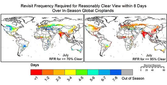
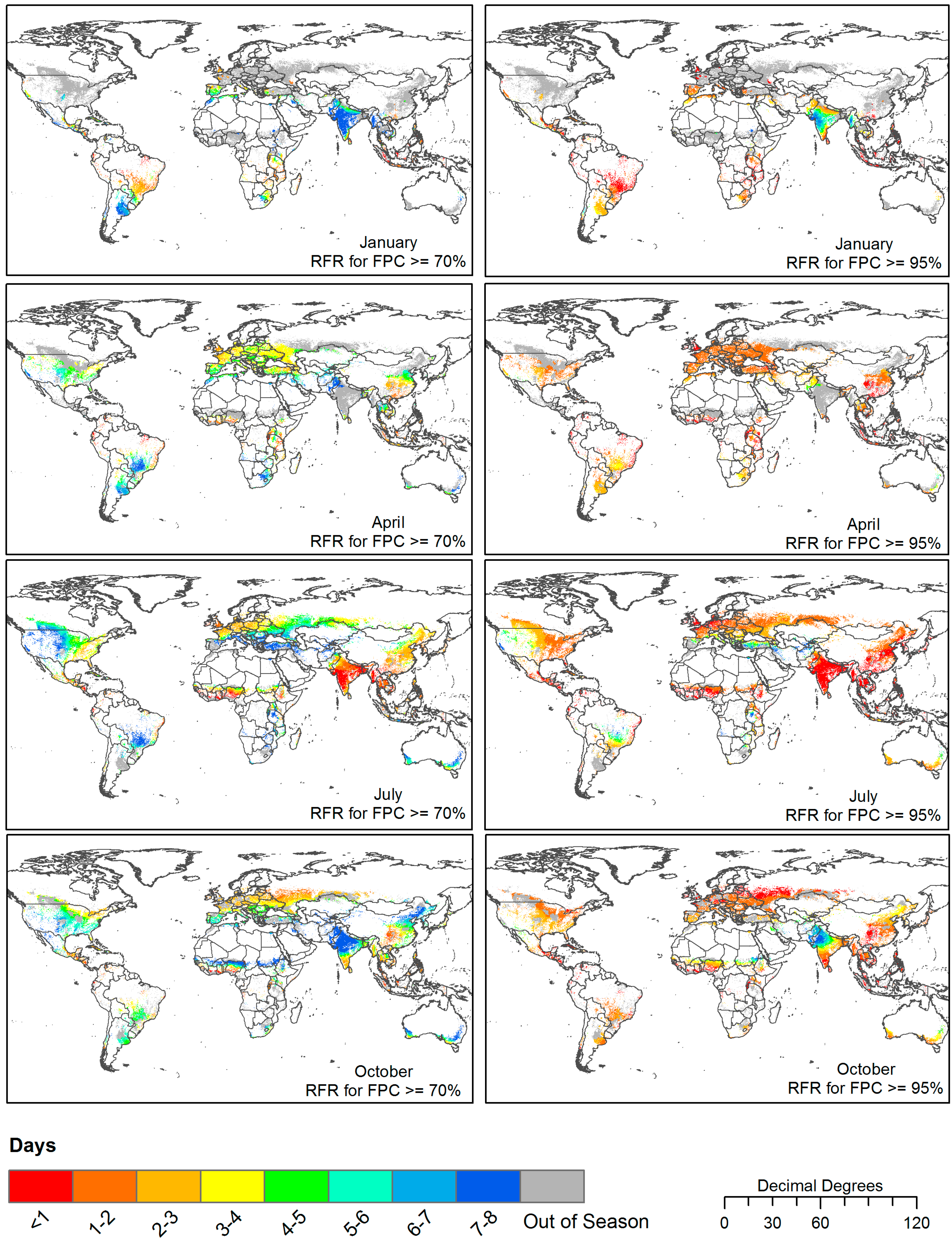
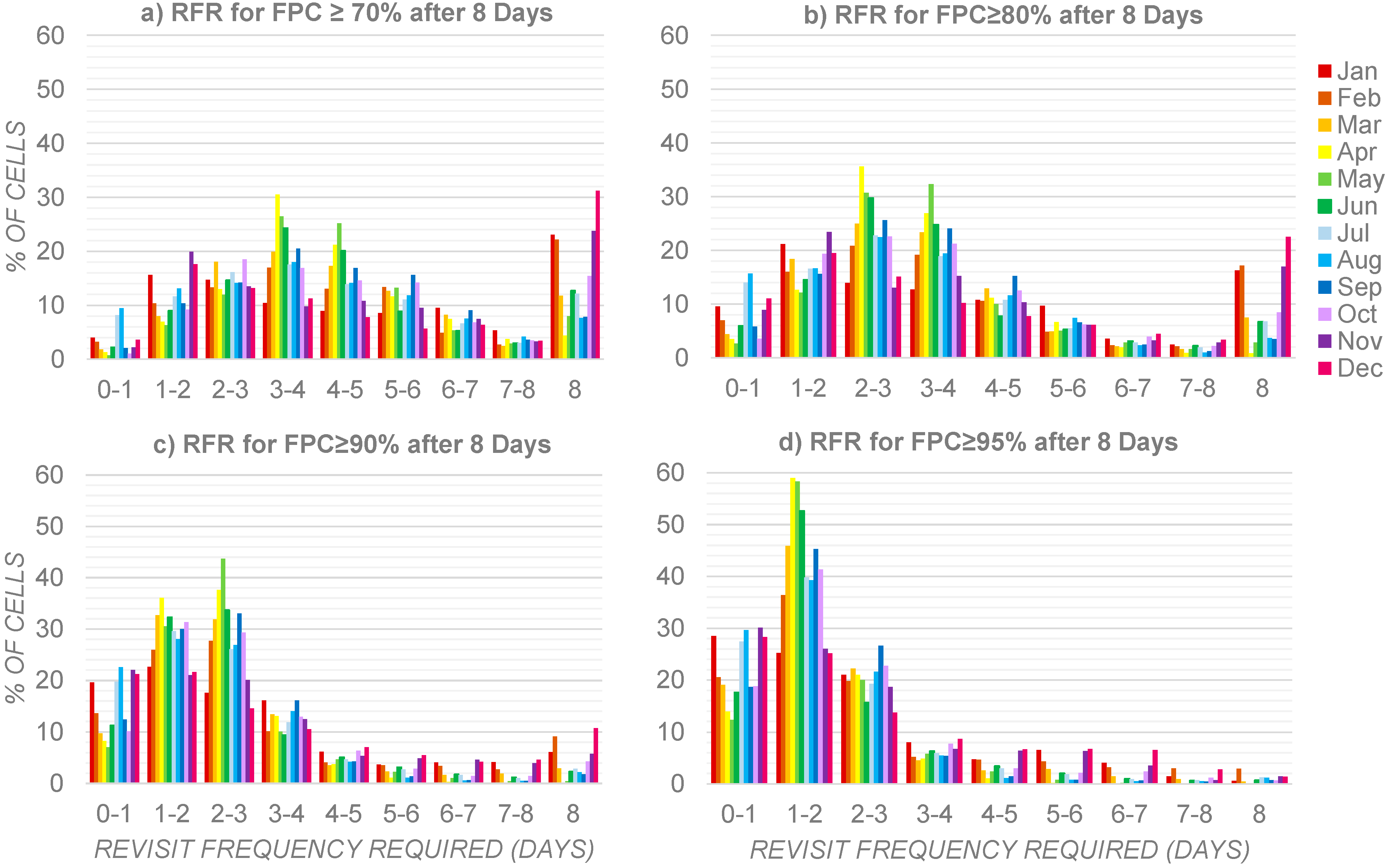
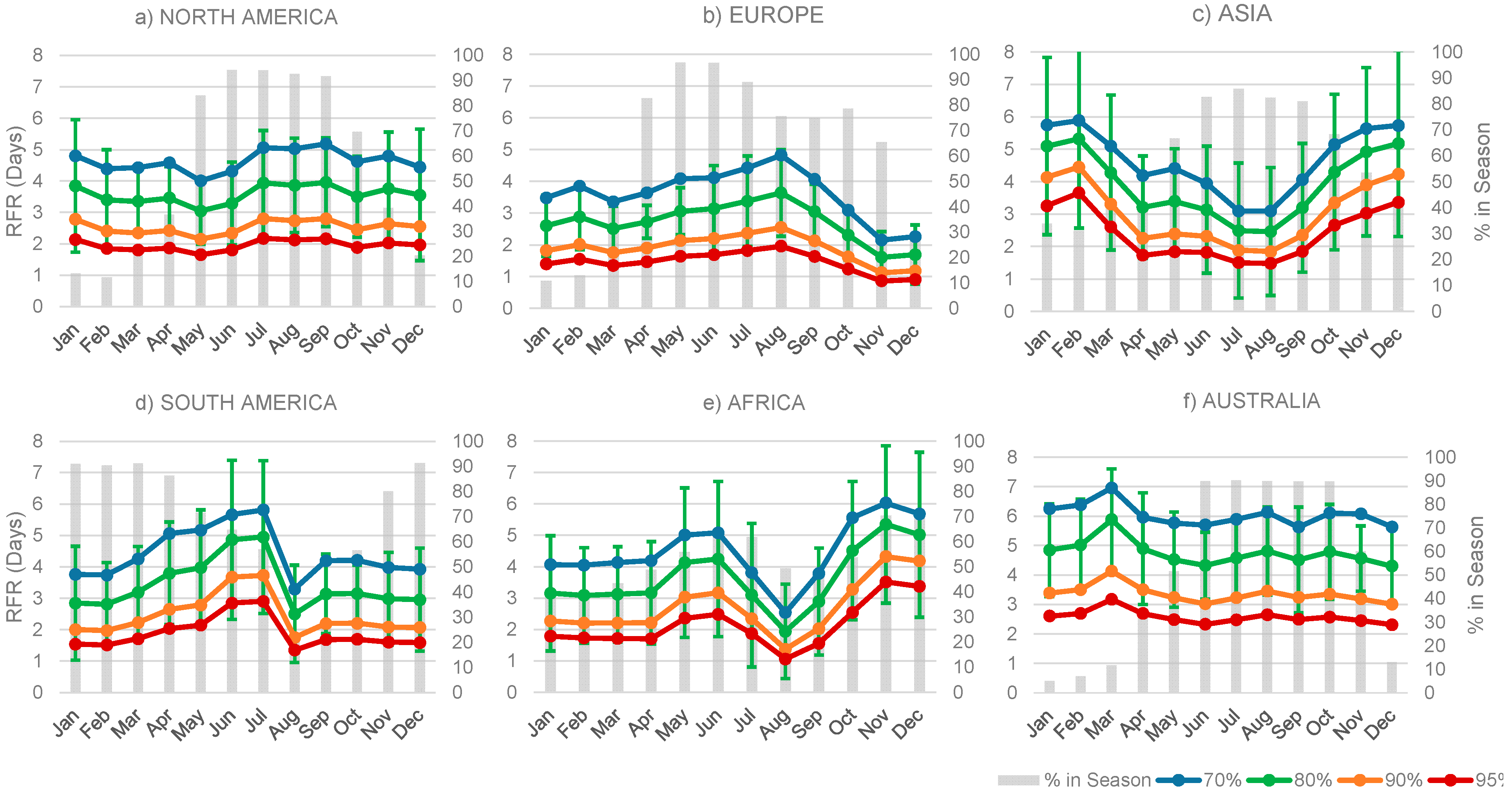
2.3. Input Datasets: How Frequently to Image for (Reasonably) Clear Views

Whether the requirement (Table 1, Column D) is for a virtually clear view of every pixel within a scene or a partially clear scene is contingent upon the application and the expert opinion of the user, although increasingly scientists are moving toward per pixel analyses as opposed to per scene analyses [66,68,77]. To evaluate the multiple thresholds of clarity that may be acceptable, the four definitions of a reasonably clear view will be presented (70%, 80%, 90%, and 95%), all based on daily MODIS Terra surface reflectance (MOD09) quality assessment bits from 2000 to 2012 [78]. Any 1-km pixel that contained cloud was flagged as cloudy and then aggregated to 0.05° to show daily percentage cloudy for each day and for each year analyzed. From this, the average percentage cloudy (and its complement, the average percentage clear) for each cell and for each day of the year between 2000 and 2012 was calculated. For the present analysis, this dataset has been further aggregated to show average cloudiness for each calendar month. The full dataset has been documented in Whitcraft et al. (2015) [3].
Cloud cover varies seasonally, geographically, and diurnally, and as such the revisit frequency required (RFR) in order to satisfy a given reasonably clear view requirement (referred to as the “Effective Temporal Resolution” in Table 1) within a certain period varies throughout the year, with location, and also with the acceptable cloud threshold [3,79,80,81,82,83,84,85,86,87,88,89]. As the great majority of moderate resolution EO satellites have morning overpasses, the revisit frequency required herein will be presented assuming a morning (10:30 am local solar time) overpass.
Multi-date image compositing is a common approach to overcoming issues of cloud occultation [19,20,81,90,91,92]. In areas impacted by cloud cover, multiple data acquisitions are necessary in order to piece together a cell or an area with an acceptable final percentage clear (FPC). The revisit frequency required (RFR) to yield a cell with a given FPC (here, 70%, 80%, 90%, or 95% clear) within a certain number of days (d; here, 8 days) is equal to that number of days divided by the number of necessary acquisitions:
RFR   =   d   ÷   [   ln ( 1   FPC 100 ) ln ( P ( cloud p o r t i o n )   ]
where P(cloudportion) is the probability that any given portion of a cell is cloudy during a given observation. This probability is the same as the average percentage of a cell that is cloudy, and is based on the assumption that the percentage of any cell that is cloudy is the same as the probability that any given portion of a cell is cloudy. As described in Roy et al. (2006) [93], from which Equation 1 is adapted, this may underestimate the impact of clouds, and as such, it may provide a slightly optimistic outlook for the RFR to meet a reasonable FPC requirement within a certain period (d).

2.4. Generation of Requirements Maps

For simplicity of analysis, the year has been divided into its calendar months, and acquisitions are considered necessary during any month for which even one day is actively cropped (based on median SOS and median EOS from Whitcraft et al. (2014) [2]). This may lead to overestimation of the period for which imagery is required, but variability in year-to-year cropping practices and the negative potential impacts of missing the SOS justifies the potentially expanded period of acquisition.
With all of the components of the EO requirements established, it is possible to articulate the spatially explicit revisit frequency requirements for any optical data requirement in Table 1. This is accomplished by assembling these individual layers to provide spatially explicit monthly estimates of revisit frequency required to yield a reasonably clear view within a certain time period, only for the extent of crops that are actively growing (or, in the case of those requirements for imagery during the non-AGS (not discussed herein), for all croplands that are out of season) for that month. For each individual requirement in Table 1, Column D, there is at least a minimum and a preferred “effective temporal resolution” (same as RFR) requirement during the AGS, and in Requirements #4 and #10 a tertiary requirement for imagery outside of the AGS. The focus herein will be on Requirement #5 (10–100m; optical data (visible, reflected-infrared, thermal infrared)), detailing the average RFR to meet each reasonably clear view requirement for its preferred (8-day) effective temporal resolution requirement for all field sizes during each month of the agricultural growing season (Table 1, Column D). While 16-day data has commonly been used [35,91,94], the precision and accuracy of satellite-based estimates, particularly regarding yield and condition, would be improved by having reasonably clear views every 8 days [19,21].

3. Results

As was shown in Whitcraft et al. (2015) [3], the early-to-mid AGS (between the start of season and shortly after the NDVI maximum) in most areas is more heavily occluded by cloud cover than is the late (or non-) AGS. This is particularly noticeable in India and surrounding areas, where the start of the season (May–June) is followed shortly by the Summer Monsoon (Figure 1). During the months after the Monsoon period for which crops are in season (approximately October–March), the revisit frequency requirement for much of the impacted area (especially India) is around 5–8 days in all scenarios. However, during the monsoon months (June–August), the RFR is almost always less than 1 day, even in the FPC ≥ 70% scenario. Only southern Brazil comes close to having a similar magnitude of seasonal divergence in revisit frequency required (Figure 1).
The revisit frequency required to yield a view at least 70% clear within 8 days varies throughout the calendar year and the AGS, ranging from < 1 day to exactly 8 days, with a mean ranging between 3.9 and 4.8 days, depending on the month (Figure 2a). For November through February, a single revisit (RFR = 8 days) is all that is required to yield a view at least 70% clear for 22%–31% of actively cropped cells globally, although the months with the greatest quantity of actively growing cropland (May–September) are often the most impacted by clouds and therefore require the most frequent revisit (cropland per month is shown in Figure 3a–f). Many of these cells with an RFR of 8 days fall in the areas of South and Southeast Asia, outside of the aforementioned Monsoon season (October to March). For April–June, 3–5 days is the most common revisit frequency required (20%–31% of cells), while in July–October, the required revisit frequency ranges broadly from 2 to 6 days. There are some cells for which a revisit rate of less than 1 day is required, but only during the months of July and August does this account for more than 4% of cells (8% and 9%, respectively). In sum, to be at least 70% clear, 44%–55% of in-season cells require a revisit rate more frequent than every 4 days, while 7%–23% of in-season cells require a revisit rate more frequent than every 2 days.
Not surprisingly, the higher the threshold of acceptable clarity (and the lower the threshold of acceptable cloud occlusion), the more frequent the required revisit becomes. In the FPC ≥ 80% scenario, the mean RFR decreases to 3.0–4.1 days (Figure 2b). There is also a marked decrease in the frequency with which a single revisit (RFR = 8) is all that is required (1%–23% of actively cropped cells), with 56%–79% requiring a revisit rate more frequent than every 4 days, and 15%–32% requiring a revisit rate more frequent than every 2 days. Meanwhile, in the FPC ≥ 90% scenario, the mean RFR decreases further to 2.2–3.3 days (Figure 2c), RFR = 8 days in 0–11% of actively cropped cells (with only December–February, the least pervasively cropped months, surpassing 6%), and 68%–95% require a revisit rate more frequent than every 4 days, while 38%–51% of in-season cells require a revisit rate more frequent than every 2 days. Finally, obtaining a view at least 95% clear after 8 days would require, on average, a revisit frequency of 1.7–2.6 days, with 76% to nearly 99% of actively cropped cells requiring a revisit rate more frequent than every 4 days (Figure 2d).
Figure 1. The revisit frequency required (RFR) to probabilistically yield a view at least 70% (left) or 95% (right) clear within 8 days over in-season croplands, for the representative months of January, April, July, and October. Areas containing cropland out of season are shown in gray. Resolution is 0.05°. Full map figures for all months can be found in the Supplemental Materials.
Remotesensing 07 01461 g001
Figure 2. Histograms showing the revisit frequency required (RFR) to yield a view with a certain minimum FPC within 8 days over actively cropped cells during each month of the year. (a) FPC ≥ 70%, (b) FPC ≥ 80%, (c) FPC ≥ 90%, and (d) FPC ≥ 95%.
Remotesensing 07 01461 g002
On a global basis, securing a view at least 80% clear requires a revisit rate on average 0.88 days more frequent than does a 70% clear view. Increasing the clarity from 80% to 90% requires a revisit rate on average 0.91 days more frequent, while increasing clarity from 90% to 95% translates to an RFR 0.57 days more frequent. However, there is considerable variability at the continental-to-local level, as well as throughout the year. This month-to-month and geographic variability is illustrated in Figure 3a–f, wherein the mean monthly RFRs are shown for each of the FPCs for each of the continents, plotted over the percentage of total cropland actively in season for that continent. Still, as is clear in the map figures (Figure 1) and is illustrated in Figure 3a–f by the standard deviation overplot, there is a great deal of fine scale variability in cloud cover. The largest within-region variability in RFR occurs in November–January in North America, June–August in Europe, December–February in Asia, June–July in South America, May–July and October–December in Africa, and March–April and September in Australia. Additionally, Africa and Asia, very large land masses that span broad latitudinal gradients, have the highest within-regional variability across all months (1.5–2.6 days and 1.6–2.9 days, respectively, depending on the month). This pattern in standard within-region variability is observed in the other FPC scenarios as well (not plotted).
Figure 3. For each continent (af), the mean revisit frequency required (RFR) to yield, every 8 days, an FPC of at least 70%, 80%, 90%, or 95% clear (left axis), on a monthly basis. The error bars (mean ± 1 standard deviation) plotted for the FPC ≥ 80% case illustrate sub-continental variability. Also plotted is the percentage of croplands in that continent that are in season at any point during that month (right axis), as indicated by Fritz et al. (2015) [1] and Whitcraft et al. (2014) [2].
Remotesensing 07 01461 g003

4. Discussion & Future Research

The RFR varies throughout the year and geographically, as well as with the threshold of acceptable cloud cover. If data that are at least 70% clear are required within a given period (8 days), then 44%–55% of global cells require a revisit frequency less than half the length of that given period (i.e., <4 days for a reasonably clear view within 8 days), although during November–February, 22%–31% of cells could be satisfied by only a single revisit within the given period (i.e., every 8 days). Meanwhile, many areas require revisits more frequently than every 2 days in order to probabilistically meet a requirement for reasonably clear views every 8 days, even with an FPC as low as 70%. In areas with persistent and pervasive cloud occultation, the costs may outweigh the benefits for monitoring with optical data. SAR data algorithms are currently being prototyped and analyzed for operational monitoring applications [57,64,95,96,97].
For over 40 years, moderate spatial resolution polar-orbiting optical remote sensing instruments have passed over areas of the Earth at least every 16–18 days, with much of the Landsat program’s history having 8–9 day overpass frequency, although data have not been systematically acquired at this rate for most areas outside of the United States [54,83,98]. In this context, it may seem surprising that the revisit frequency that is required to actually meet an 8-day requirement for reasonably clear data is in some areas less than 4 or even 2 days. However, in the context of global agricultural monitoring activities such as crop condition monitoring and yield forecasting, which have traditionally relied upon daily data, this revelation is not unexpected. In order to yield moderate resolution results at the regional to global scale, it is necessary to rethink the way in which we have historically approached moderate resolution systems’ design and/or to consider a multi-mission constellation approach to monitoring [60,77].
There remain several questions that require addressing in the development of satellite-based EO requirements for agricultural monitoring. First, the requirement evaluated (#5) is preferred for the full cropland extent, but data acquired on a sampled basis will still yield important results [73,99,100,101]. The location and extent of the statistical sampling frame will vary over time and with target crop, and thus the requirements over the full extent of actively growing large, medium, and small fields have been analyzed, and can later be refined geographically to represent sample sites. It could be beneficial to design a sampling strategy with these cloud constraints in mind. Secondly, an investigation into our current, near-term, and mid-term EO systems revisit capabilities would provide valuable insight into our missions’ capacity to meet such requirements. Many of the required revisit frequencies articulated herein are well beyond the capabilities of any single existing moderate resolution program or mission. This demonstrates that with current proven capabilities, a multi-mission, multi-space agency constellation approach is necessary for operational monitoring in the moderate resolution domain. Precisely how these constellations might operate requires further analysis, which can be found in this issue in Whitcraft et al. [70].
In the present analysis, the resultant RFR from Equation (1) is often a non-integer. A non-integer revisit is an impossibility with polar-orbiting, sun-synchronous imaging systems, and when translating into data requests it will have to be altered to align with real-world orbital capabilities. However, data coordination at this level is beyond the scope of this present discussion, but merits further research before implementation.
As the threshold of acceptable cloud cover decreases (i.e., the desired clarity increases), the revisits must be 0.5–1.2 days more frequent, depending on month, than each antecedent FPC threshold. The threshold of acceptable cloud cover will vary with the monitoring application and spatial resolution of imaging instruments, among other factors. For this reason, research should be conducted to analyze how these variable cloud cover amounts impact the production of each target product, investigating the utility and limitations of data with different cloud cover thresholds.
Finally, for the synthetic aperture radar (SAR) requirements detailed in Table 1, Requirements #6 and #9, the “where” requirement identifies “persistently cloudy” areas. It is necessary to delineate precisely which regions are “persistently cloudy” and therefore require microwave SAR acquisitions, a topic that will also be addressed in the accompanying paper [70].

5. Conclusions

Neither the problem of food insecurity nor the impact of increased agricultural market volatility is likely to disappear without policy interventions formed from sound scientific evidence. As such, it is crucial to acquire EO data of sufficient quantity, quality, and accessibility to generate informational products about local, regional, and global food production. In this vein, categorical Earth observation data requirements for global agricultural monitoring have been established by the GEO Agricultural Monitoring Community of Practice and the CEOS Ad Hoc Team for GEOGLAM, and are introduced here in Table 1. Further, these descriptive requirements have been made spatially explicit through the inclusion of the growing season calendars from Whitcraft et al. (2014 [2]; when to image), a “best available” cropland mask along with a field size distribution layer (Fritz et al. (2015) [1]; where [fine vs. moderate vs. coarse] data are required), and the cloud cover information detailed in Whitcraft et al. (2015 [3]; how frequently to image given a particular reasonably clear view requirement). We have introduced a method for combining these datasets to reveal the revisit frequency that would be required in order to probabilistically yield a reasonably clear view (defined as at least 70%, 80%, 90%, or 95% clear) within 8 days during each month for actively cropped areas at 0.05°. This is a novel framework for synthesizing multiple layers of information to create spatially explicit, quantitative estimates to which CEOS and space agency data acquisition teams can respond. As such, the spatially explicit requirements articulated herein provide critical inputs into a data acquisition strategy for global agricultural monitoring in the context of GEOGLAM, and highlight the need for a collaborative, multi-mission response to a pressing global issue.

Acknowledgments

The authors would like to acknowledge the GEO Agriculture Monitoring Community of Practice, and the CEOS Ad Hoc Team for GEOGLAM. In particular, we thank Pierre Defourny (UCL) and Brian Killough (NASA-LaRC) for their participation in and contributions to the development and refinement of the GEOGLAM requirements table. We thank Eric Vermote (NASA-GSFC) for the production of the cloud cover datasets utilized herein. We thank Samuel Goward (UMD) and Jeffrey Masek (NASA-GSFC) for their feedback and guidance. We also acknowledge the NASA Earth and Space Science Fellowship (NNX11AL56H) and NASA Applied Sciences (NNX11AQ79G) for their support of this work.

Author Contributions

All three authors took part in the development of the requirements table. Alyssa K. Whitcraft designed the research, generated and interpreted the results, and drafted the manuscript. Inbal Becker-Reshef and Christopher Justice both contributed substantially to research design, with Becker-Reshef providing crucial insight into dataset choice and refinement. All authors revised the manuscript, and provided insights regarding future research and discussion of results.

Conflicts of Interest

The authors declare no conflict of interest.

References

  1. Fritz, S.; See, L.; McCallum, I.; You, L.; Bun, A.; Moltchanova, E.; Duerauer, M.; Albrecht, F.; Schill, C.; Perger, C.; et al. Mapping global cropland and field size. Glob. Change Biol. 2015. [Google Scholar] [CrossRef] [Green Version]
  2. Whitcraft, A.K.; Becker-Reshef, I.; Justice, C.O. Agricultural growing season calendars derived from MODIS surface reflectance. Int. J. Digit. Earth 2014. [Google Scholar] [CrossRef]
  3. Whitcraft, A.K.; Vermote, E.F.; Becker-Reshef, I.; Justice, C.O. Cloud cover throughout the agricultural growing season: Impacts on passive optical earth observations. Remote Sens. Environ. 2015, 156, 438–447. [Google Scholar] [CrossRef]
  4. Developing a Strategy for Global Agricultural Monitoring in the framework of Group on Earth Observations (GEO) Workshop Report. Available online: http://www.fao.org/gtos/igol/docs/meeting-reports/07-geo-ag0703-workshop-report-nov07.pdf (accessed on 27 January 2015).
  5. Duveiller, G.; López-Lozano, R.; Seguini, L.; Bojanowski, J.S.; Baruth, B. Optical remote sensing requirements for operational crop monitoring and yield forecasting in Europe. In Proceedings of Sentinel-3 OLCI/SLSTR and MERIS/(A) ATSR Workshop, ESA SP-711, Frascati, Italy, 15–19 October 2012.
  6. Parihar, J.S.; Justice, C.; Soares, J.; Leo, O.; Kosuth, P.; Jarvis, I.; Williams, D.; Bingfang, W.; Latham, J.; Becker-Reshef, I. GEO-GLAM: A GEOSS-G20 initiative on global agricultural monitoring. In Proceedings of the 39th COSPAR Scientific Assembly, Mysore, India, 14–22 July 2012.
  7. Soares, J.; Williams, M.; Wu, B.; Leo, O.; Febre, P.; Huynh, F.; Kosuth, P.; Lepoutre, D.; Parihar, J.S.; Scarascia-Mugnozza, G.; et al. Strengthening Global Agricultural Monitoring: Improving Sustainable Data for Worldwide Food Security & Commodity Market Transparency 2011. Available online: http://www.earthobservations.org/documents/cop/ag_gams/201106_g20_global_agricultural_monitoring_initiative.pdf (accessed on 27 January 2015).
  8. Committee on Earth Observation Satellites. CEOS Acquisition Strategy for GEOGLAM Phase 1. Available online: http://ceos.org/images/Plenary2013/25-CEOS_Acquisition_Strategy_for_GEOGLAM_Phase-1_v1-0.pdf (accessed on 14 November 2014).
  9. GEO-GEOGLAM (Global Agirculture Monitoring Initiative). Available online: http://www.earthobservations.org/geoglam_cop.php (accessed on 4 November 2014).
  10. Duveiller, G.; Weiss, M.; Baret, F.; Defourny, P. Retrieving wheat green area index during the growing season from optical time series measurements based on neural network radiative transfer inversion. Remote Sens. Environ. 2011, 115, 887–896. [Google Scholar] [CrossRef]
  11. Wiegand, C.L.; Gerbermann, A.H.; Gallo, K.P.; Blad, B.L.; Dusek, D. Multisite analyses of spectral-biophysical data for corn. Remote Sens. Environ. 1990, 33, 1–16. [Google Scholar] [CrossRef]
  12. Wiegand, C.L.; Maas, S.J.; Aase, J.K.; Hatfield, J.L.; Pinter Jr, P.J.; Jackson, R.D.; Kanemasu, E.T.; Lapitan, R.L. Multisite analyses of spectral-biophysical data for wheat. Remote Sens. Environ. 1992, 42, 1–21. [Google Scholar] [CrossRef]
  13. Wiegand, C.L.; Richardson, A.J. Use of spectral vegetation indices to infer leaf area, evapotranspiration and yield: I. Rationale. Agron. J. 1990, 82, 623–629. [Google Scholar] [CrossRef]
  14. Richardson, A.J.; Wiegand, C.L.; Wanjura, D.F.; Dusek, D.; Steiner, J.L. Multisite analyses of spectral-biophysical data for sorghum. Remote Sens. Environ. 1992, 41, 71–82. [Google Scholar] [CrossRef]
  15. Duveiller, G.; Defourny, P.; Gérard, B. A method to determine the appropriate spatial resolution required for monitoring crop growth in a given agricultural landscape. In Proceedings of the 2008 IEEE International Geoscience and Remote Sensing Symposium, IGARSS 2008, Boston, MA, USA, 7–11 July 2008; pp. 562–565.
  16. Duveiller, G.; Defourny, P. A conceptual framework to define the spatial resolution requirements for agricultural monitoring using remote sensing. Remote Sens. Environ. 2010, 114, 2637–2650. [Google Scholar] [CrossRef]
  17. USDA National Agricultural Statistics Service. Quick Stats 2.0. Available online: http://www.nass.usda.gov/Charts_and_Maps/ Crop_Progress_&_Condition/ (accessed on 16 August 2013).
  18. Zaks, D.P.M.; Kucharik, C.J. Data and monitoring needs for a more ecological agriculture. Environ. Res. Lett. 2011, 6, 014017. [Google Scholar] [CrossRef]
  19. Johnson, D.M. An assessment of pre-and within-season remotely sensed variables for forecasting corn and soybean yields in the United States. Remote Sens. Environ. 2014, 141, 116–128. [Google Scholar] [CrossRef]
  20. Sakamoto, T.; Gitelson, A.A.; Arkebauer, T.J. MODIS-based corn grain yield estimation model incorporating crop phenology information. Remote Sens. Environ. 2013, 131, 215–231. [Google Scholar] [CrossRef]
  21. Becker-Reshef, I.; Vermote, E.; Lindeman, M.; Justice, C. A generalized regression-based model for forecasting winter wheat yields in Kansas and Ukraine using MODIS data. Remote Sens. Environ. 2010, 114, 1312–1323. [Google Scholar] [CrossRef]
  22. Boken, V.K.; Shaykewich, C.F. Improving an operational wheat yield model using phenological phase-based Normalized Difference Vegetation Index. Int. J. Remote Sens. 2002, 23, 4155–4168. [Google Scholar] [CrossRef]
  23. Rembold, F.; Atzberger, C.; Savin, I.; Rojas, O. Using low resolution satellite imagery for yield prediction and yield anomaly detection. Remote Sens. 2013, 5, 1704–1733. [Google Scholar] [CrossRef] [Green Version]
  24. Fan, J.; Wu, B. A methodology for retrieving cropping index from NDVI profile. J. Remote Sens. 2004, 8, 628–636. [Google Scholar]
  25. Biradar, C.M.; Xiao, X. Quantifying the area and spatial distribution of double- and triple-cropping croplands in India with multi-temporal MODIS imagery in 2005. Int. J. Remote Sens. 2011, 32, 367–386. [Google Scholar] [CrossRef]
  26. Duveiller, G.; Baret, F.; Defourny, P. Crop specific green area index retrieval from MODIS data at regional scale by controlling pixel-target adequacy. Remote Sens. Environ. 2011, 115, 2686–2701. [Google Scholar] [CrossRef]
  27. Galford, G.L.; Mustard, J.F.; Melillo, J.; Gendrin, A.; Cerri, C.C.; Cerri, C.E. Wavelet analysis of MODIS time series to detect expansion and intensification of row-crop agriculture in Brazil. Remote Sens. Environ. 2008, 112, 576–587. [Google Scholar] [CrossRef]
  28. Guindin-Garcia, N.; Gitelson, A.A.; Arkebauer, T.J.; Shanahan, J.; Weiss, A. An evaluation of MODIS 8- and 16-day composite products for monitoring maize green leaf area index. Agric. For. Meteorol. 2012, 161, 15–25. [Google Scholar]
  29. Justice, C.O.; Vermote, E.; Townshend, J.R.G.; DeFries, R.; Roy, D.P.; Hall, D.K.; Salomonson, V.V.; Privette, J.L.; Riggs, G.; Strahler, A.; et al. The Moderate Resolution Imaging Spectroradiometer (MODIS): Land remote sensing for global change research. IEEE Trans. Geosci. Remote Sens. 1998, 36, 1228–1249. [Google Scholar] [CrossRef]
  30. Justice, C.O.; Vermote, E.; Privette, J.; Sei, A. The evolution of US moderate resolution optical land remote sensing from AVHRR to VIIRS. In Land Remote Sensing and Global Environmental Change; Springer: Berlin, Germany, 2011; pp. 781–806. [Google Scholar]
  31. Justice, C.O.; Román, M.O.; Csiszar, I.; Vermote, E.F.; Wolfe, R.E.; Hook, S.J.; Friedl, M.; Wang, Z.; Schaaf, C.B.; Miura, T. Land and cryosphere products from Suomi NPP VIIRS: Overview and status. J. Geophys. Res.: Atmos. 2013, 118, 9753–9765. [Google Scholar] [CrossRef]
  32. Pan, Y.; Li, L.; Zhang, J.; Liang, S.; Zhu, X.; Sulla-Menashe, D. Winter wheat area estimation from MODIS-EVI time series data using the crop proportion phenology index. Remote Sens. Environ. 2012, 119, 232–242. [Google Scholar] [CrossRef]
  33. Pittman, K.; Hansen, M.C.; Becker-Reshef, I.; Potapov, P.V.; Justice, C.O. Estimating global cropland extent with multi-year MODIS data. Remote Sens. 2010, 2, 1844–1863. [Google Scholar] [CrossRef]
  34. Sakamoto, T.; Wardlow, B.D.; Gitelson, A.A.; Verma, S.B.; Suyker, A.E.; Arkebauer, T.J. A two-step filtering approach for detecting maize and soybean phenology with time-series MODIS data. Remote Sens. Environ. 2010, 114, 2146–2159. [Google Scholar] [CrossRef]
  35. Sakamoto, T.; Yokozawa, M.; Toritani, H.; Shibayama, M.; Ishitsuka, N.; Ohno, H. A crop phenology detection method using time-series MODIS data. Remote Sens. Environ. 2005, 96, 366–374. [Google Scholar] [CrossRef]
  36. Wardlow, B.D.; Egbert, S.L.; Kastens, J.H. Analysis of time-series MODIS 250 m vegetation index data for crop classification in the US Central Great Plains. Remote Sens. Environ. 2007, 108, 290–310. [Google Scholar] [CrossRef]
  37. Wardlow, B.D.; Egbert, S.L. Large-area crop mapping using time-series MODIS 250 m NDVI data: An assessment for the U.S. Central Great Plains. Remote Sens. Environ. 2008, 112, 1096–1116. [Google Scholar] [CrossRef]
  38. Xiao, X.; Boles, S.; Liu, J.; Zhuang, D.; Frolking, S.; Li, C.; Salas, W.; Moore, B., III. Mapping paddy rice agriculture in southern China using multi-temporal MODIS images. Remote Sens. Environ. 2005, 95, 480–492. [Google Scholar] [CrossRef]
  39. Wu, B.; Meng, J.; Li, Q.; Yan, N.; Du, X.; Zhang, M. Remote sensing-based global crop monitoring: Experiences with China’s CropWatch system. Int. J. Digit. Earth 2014, 7, 113–137. [Google Scholar] [CrossRef]
  40. Ozdogan, M. The spatial distribution of crop types from MODIS data: Temporal unmixing using Independent Component Analysis. Remote Sens. Environ. 2010, 114, 1190–1204. [Google Scholar] [CrossRef]
  41. Pax-Lenney, M.; Woodcock, C.E. The effect of spatial resolution on the ability to monitor the status of agricultural lands. Remote Sens. Environ. 1997, 61, 210–220. [Google Scholar] [CrossRef]
  42. Conrad, C.; Fritsch, S.; Zeidler, J.; Rücker, G.; Dech, S. Per-field irrigated crop classification in arid Central Asia using SPOT and ASTER data. Remote Sens. 2010, 2, 1035–1056. [Google Scholar] [CrossRef]
  43. Guerschman, J.P.; Paruelo, J.M.; Bella, C.D.; Giallorenzi, M.C.; Pacin, F. Land cover classification in the Argentine Pampas using multi-temporal Landsat TM data. Int. J. Remote Sens. 2003, 24, 3381–3402. [Google Scholar] [CrossRef]
  44. Doraiswamy, P.C.; Hatfield, J.L.; Jackson, T.J.; Akhmedov, B.; Prueger, J.; Stern, A. Crop condition and yield simulations using Landsat and MODIS. Remote Sens. Environ. 2004, 92, 548–559. [Google Scholar] [CrossRef]
  45. MacDonald, R.B.; Hall, F.G. Global crop forecasting. Science 1980, 208, 670–679. [Google Scholar] [CrossRef] [PubMed]
  46. MacDonald, R.B.; Hall, F.G.; Erb, R.B. The use of Landsat data in a large area crop inventory experiment (LACIE). LARS Symp. 1975, 46, IB1–IB23. [Google Scholar]
  47. Lobell, D.B.; Asner, G.P. Cropland distributions from temporal unmixing of MODIS data. Remote Sens. Environ. 2004, 93, 412–422. [Google Scholar] [CrossRef]
  48. Kauth, R.J.; Thomas, G.S. The tasselled cap—A graphic description of the spectral-temporal development of agricultural crops as seen by Landsat. LARS Symp. 1976, 159, 4B41–4B51. [Google Scholar]
  49. Odenweller, J.B.; Johnson, K.I. Crop identification using Landsat temporal-spectral profiles. Remote Sens. Environ. 1984, 14, 39–54. [Google Scholar] [CrossRef]
  50. Genovese, G.; Vignolles, C.; Nègre, T.; Passera, G. A methodology for a combined use of normalised difference vegetation index and CORINE land cover data for crop yield monitoring and forecasting. A case study on Spain. Agronomie 2001, 21, 91–111. [Google Scholar] [CrossRef]
  51. Homer, C.; Dewitz, J.; Fry, J.; Coan, M.; Hossain, N.; Larson, C.; Herold, N.; McKerrow, A.; VanDriel, J.N.; Wickham, J. Completion of the 2001 National land cover database for the counterminous United States. Photogramm. Eng. Remote Sens. 2007, 73, 337–341. [Google Scholar]
  52. Liu, J.; Liu, M.; Tian, H.; Zhuang, D.; Zhang, Z.; Zhang, W.; Tang, X.; Deng, X. Spatial and temporal patterns of China’s cropland during 1990–2000: an analysis based on Landsat TM data. Remote Sens. Environ. 2005, 98, 442–456. [Google Scholar] [CrossRef]
  53. Vogelmann, J.E.; Howard, S.M.; Yang, L.; Larson, C.R.; Wylie, B.K.; van Driel, N. Completion of the 1990s national land cover data set for the conterminous United States from Landsat thematic mapper data and ancillary data sources. Photogramm. Eng. Remote Sens. 2001, 67, 650–662. [Google Scholar]
  54. Wulder, M.A.; White, J.C.; Goward, S.N.; Masek, J.G.; Irons, J.R.; Herold, M.; Cohen, W.B.; Loveland, T.R.; Woodcock, C.E. Landsat continuity: Issues and opportunities for land cover monitoring. Remote Sens. Environ. 2008, 112, 955–969. [Google Scholar] [CrossRef]
  55. Li, Q.; Wu, B. Accuracy assessment of planted area proportion using Landsat TM imagery. J. Remote Sens. 2004, 8, 581–587. [Google Scholar]
  56. Brisco, B.; Brown, R.J. Multidate SAR/TM synergism for crop classification in western Canada. Photogramm. Eng. Remote Sens. 1995, 61, 1009–1014. [Google Scholar]
  57. McNairn, H.; Champagne, C.; Shang, J.; Holmstrom, D.; Reichert, G. Integration of optical and Synthetic Aperture Radar (SAR) imagery for delivering operational annual crop inventories. ISPRS J. Photogramm. Remote Sens. 2009, 64, 434–449. [Google Scholar] [CrossRef]
  58. Parihar, J.S.; Oza, M.P. FASAL: An integrated approach for crop assessment and production forecasting. Proc. SPIE 2006, 6411. [Google Scholar] [CrossRef]
  59. Goward, S.N.; Arvidson, T.; Williams, D.L.; Irish, R.; Irons, J.R. Moderate Spatial Resolution Optical Sensors; SAGE Publications Ltd.: London, UK, 2009. [Google Scholar]
  60. Goward, S.; Williams, D.; Arvidson, T.; Irons, J. The future of Landsat-class remote sensing. In Land Remote Sensing and Global Environmental Change; Springer: Berlin, Germany, 2011; pp. 807–834. [Google Scholar]
  61. Goward, S.; Chander, G.; Pagnutti, M.; Marx, A.; Ryan, R.; Thomas, N.; Tetrault, R. Complementarity of ResourceSat-1 AWiFS and Landsat TM/ETM+ sensors. Remote Sens. Environ. 2012, 123, 41–56. [Google Scholar] [CrossRef]
  62. Wulder, M.A.; Masek, J.G.; Cohen, W.B.; Loveland, T.R.; Woodcock, C.E. Opening the archive: How free data has enabled the science and monitoring promise of Landsat. Remote Sens. Environ. 2012, 122, 2–10. [Google Scholar] [CrossRef]
  63. Roy, D.P.; Wulder, M.A.; Loveland, T.R.; Allen, R.G.; Anderson, M.C.; Helder, D.; Irons, J.R.; Johnson, D.M.; Kennedy, R.; Scambos, T.A. Landsat-8: Science and product vision for terrestrial global change research. Remote Sens. Environ. 2014, 145, 154–172. [Google Scholar] [CrossRef]
  64. Chakraborty, M.; Patnaik, C.; Panigrahy, S.; Parihar, J.S. Monitoring of wet season rice crop at state and national level in India using multidate synthetic aperture radar data. Proc. SPIE 2006, 6411. [Google Scholar] [CrossRef]
  65. Gong, P.; Wang, J.; Yu, L.; Zhao, Y.; Zhao, Y.; Liang, L.; Niu, Z.; Huang, X.; Fu, H.; Liu, S.; et al. Finer resolution observation and monitoring of global land cover: First mapping results with Landsat TM and ETM+ data. Int. J. Remote Sens. 2013, 34, 2607–2654. [Google Scholar] [CrossRef]
  66. Hansen, M.C.; Potapov, P.V.; Moore, R.; Hancher, M.; Turubanova, S.A.; Tyukavina, A.; Thau, D.; Stehman, S.V.; Goetz, S.J.; Loveland, T.R. High-Resolution global maps of 21st-century forest cover change. Science 2013, 342, 850–853. [Google Scholar] [CrossRef] [PubMed]
  67. Johnson, D.M.; Mueller, R. The 2009 cropland data layer. Photogramm. Eng. Remote Sens. 2010, 76, 1201–1205. [Google Scholar]
  68. Roy, D.P.; Ju, J.; Kline, K.; Scaramuzza, P.L.; Kovalskyy, V.; Hansen, M.; Loveland, T.R.; Vermote, E.; Zhang, C. Web-enabled Landsat Data (WELD): Landsat ETM+ composited mosaics of the conterminous United States. Remote Sens. Environ. 2010, 114, 35–49. [Google Scholar] [CrossRef]
  69. Yu, L.; Wang, J.; Clinton, N.; Xin, Q.; Zhong, L.; Chen, Y.; Gong, P. FROM-GC: 30 m global cropland extent derived through multisource data integration. Int. J. Digit. Earth 2013, 6, 521–533. [Google Scholar] [CrossRef]
  70. Whitcraft, A.K.; Becker-Reshef, I.; Killough, B.D.; Justice, C.O. Meeting earth observation requirements for global agricultural monitoring: An evaluation of the revisit capabilities of current and planned moderate resolution optical earth observing missions. Remote Sens. 2015, 7, 1482–1503. [Google Scholar] [CrossRef]
  71. Fritz, S.; See, L.; You, L.; Justice, C.; Becker-Reshef, I.; Bydekerke, L.; Cumani, R.; Defourny, P.; Erb, K.; Foley, J.; et al. The need for improved maps of global cropland. Eos Trans. Am. Geophys. Union 2013, 94, 31–32. [Google Scholar]
  72. Friedl, M.A.; McIver, D.K.; Hodges, J.C.; Zhang, X.Y.; Muchoney, D.; Strahler, A.H.; Woodcock, C.E.; Gopal, S.; Schneider, A.; Cooper, A. Global land cover mapping from MODIS: algorithms and early results. Remote Sens. Environ. 2002, 83, 287–302. [Google Scholar] [CrossRef]
  73. GEOSS Ag 07 03 Discussion Paper: International Workshop on Impact of Climate Change on Agriculture. Available online: https://www.earthobservations.org/documents/cop/ag_gams/200912_17/200912_Agmon_Discussion%20Paper.pdf (accessed on 27 January 2015).
  74. Fritz, S.; McCallum, I.; Schill, C.; Perger, C.; Grillmayer, R.; Achard, F.; Kraxner, F.; Obersteiner, M. Geo-Wiki. Org: The use of crowdsourcing to improve global land cover. Remote Sens. 2009, 1, 345–354. [Google Scholar]
  75. Fritz, S.; McCallum, I.; Schill, C.; Perger, C.; See, L.; Schepaschenko, D.; van der Velde, M.; Kraxner, F.; Obersteiner, M. Geo-Wiki: An online platform for improving global land cover. Environ. Model. Softw. 2012, 31, 110–123. [Google Scholar] [CrossRef]
  76. Duveiller, G.; Baret, F.; Defourny, P. Remotely sensed green area index for winter wheat crop monitoring: 10-Year assessment at regional scale over a fragmented landscape. Agric. For. Meteorol. 2012, 166, 156–168. [Google Scholar] [CrossRef]
  77. Hansen, M.C.; Loveland, T.R. A review of large area monitoring of land cover change using Landsat data. Remote Sens. Environ. 2012, 122, 66–74. [Google Scholar] [CrossRef]
  78. Bréon, F.-M.; Vermote, E. Correction of MODIS surface reflectance time series for BRDF effects. Remote Sens. Environ. 2012, 125, 1–9. [Google Scholar] [CrossRef]
  79. Cairns, B. Diurnal variations of cloud from ISCCP data. Atmos. Res. 1995, 37, 133–146. [Google Scholar] [CrossRef]
  80. Kaufman, Y.J.; Remer, L.A.; Tanré, D.; Li, R.-R.; Kleidman, R.; Mattoo, S.; Levy, R.C.; Eck, T.F.; Holben, B.N.; Ichoku, C. A critical examination of the residual cloud contamination and diurnal sampling effects on MODIS estimates of aerosol over ocean. IEEE Trans. Geosci. Remote Sens. 2005, 43, 2886–2897. [Google Scholar] [CrossRef]
  81. Minnis, P.; Harrison, E.F. Diurnal variability of regional cloud and clear-sky radiative parameters derived from GOES data. Part I: Analysis method. J. Clim. Appl. Meteor. 1984, 23, 993–1011. [Google Scholar] [CrossRef]
  82. Gunderson, A.; Chodas, M. An investigation of cloud cover probability for the HyspIRI mission using MODIS cloud mask data. In Proceedings of the 2011 IEEE Aerospace Conference, Big Sky, MT, USA, 5–12 March 2011; pp. 1–14.
  83. Ju, J.; Roy, D.P. The availability of cloud-free Landsat ETM+ data over the conterminous United States and globally. Remote Sens. Environ. 2008, 112, 1196–1211. [Google Scholar] [CrossRef]
  84. Wylie, D.; Menzel, W.P. Eight years of high cloud statistics using HIRS. J. Clim. 1999, 12, 170–184. [Google Scholar] [CrossRef]
  85. Wylie, D.; Jackson, D.L.; Menzel, W.P.; Bates, J.J. Trends in global cloud cover in two decades of HIRS observations. J. Clim. 2005, 18, 3021–3031. [Google Scholar] [CrossRef]
  86. Chernokulsky, A.V.; Mokhov, I.I. Comparison of global cloud climatologies. Curr. Issues Remote Sens. Earth Space 2009, 6, 235–243. [Google Scholar]
  87. Minnis, P.; Trepte, Q.Z.; Sun-Mack, S.; Chen, Y.; Doelling, D.R.; Young, D.F.; Spangenberg, D.A.; Miller, W.F.; Wielicki, B.A.; Brown, R.R. Cloud detection in nonpolar regions for CERES using TRMM VIRS and Terra and Aqua MODIS data. IEEE Trans. Geosci. Remote Sens. 2008, 46, 3857–3884. [Google Scholar] [CrossRef]
  88. Minnis, P.; Sun-Mack, S.; Young, D.F.; Heck, P.W.; Garber, D.P.; Chen, Y.; Spangenberg, D.A.; Arduini, R.F.; Trepte, Q.Z.; Smith, W.L. CERES Edition-2 cloud property retrievals using TRMM VIRS and Terra and Aqua MODIS Data—Part I: Algorithms. IEEE Trans. Geosci. Remote Sens. 2011, 49, 4374–4400. [Google Scholar] [CrossRef]
  89. Stubenrauch, C.J.; Rossow, W.B.; Kinne, S.; Ackerman, S.; Cesana, G.; Chepfer, H.; Di Girolamo, L.; Getzewich, B.; Guignard, A.; Heidinger, A. Assessment of global cloud datasets from satellites. Bull. Am. Meteorol. Soc. 2013, 94, 1031–1049. [Google Scholar] [CrossRef]
  90. Bolton, D.K.; Friedl, M.A. Forecasting crop yield using remotely sensed vegetation indices and crop phenology metrics. Agric. For. Meteorol. 2013, 173, 74–84. [Google Scholar] [CrossRef]
  91. Chen, P.-Y.; Fedosejevs, G.; Tiscareño-LóPez, M.; Arnold, J.G. Assessment of MODIS-EVI, MODIS-NDVI and VEGETATION-NDVI composite data using agricultural measurements: An example at corn fields in Western Mexico. Environ. Monit. Assess. 2006, 119, 69–82. [Google Scholar] [CrossRef] [PubMed]
  92. Li, A.; Liang, S.; Wang, A.; Qin, J. Estimating crop yield from multi-temporal satellite data using multivariate regression and neural network techniques. Photogramm. Eng. Remote Sens. 2007, 73, 1149–1157. [Google Scholar] [CrossRef]
  93. Roy, D.P.; Lewis, P.; Schaaf, C.B.; Devadiga, S.; Boschetti, L. The global impact of clouds on the production of MODIS bidirectional reflectance model-based composites for terrestrial monitoring. Geosci. Remote Sens. Lett. 2006, 3, 452–456. [Google Scholar]
  94. Wardlow, B.D.; Kastens, J.H.; Egbert, S.L. Using USDA crop progress data for the evaluation of greenup onset date calculated from MODIS 250-meter data. Photogramm. Eng. Remote Sens. 2006, 72, 1225–1234. [Google Scholar] [CrossRef]
  95. Takashima, S.; Oyoshi, K.; Fukuda, T.; Okumura, T.; Tomiyama, N.; Nagano, T. Asia rice crop monitoring in GEO GLAM. In Proceedings of the 2013 IEEE Second International Conference on Agro-Geoinformatics (Agro-Geoinformatics), Fairfax, VA, USA, 12–16 August 2013; pp. 398–401.
  96. Takashima, S.S.; Oyoshi, K.; Okumura, T.; Tomiyama, N.; Rakwatin, P. Rice crop yield monitoring system prototyping and its evaluation result. In Proceedings of the 2012 IEEE First International Conference on Agro-Geoinformatics (Agro-Geoinformatics), Shanghai, China, 2–4 August 2012; pp. 1–4.
  97. McNairn, H.; Shang, J.; Jiao, X.; Champagne, C. The contribution of ALOS PALSAR multipolarization and polarimetric data to crop classification. IEEE Trans. Geosci. Remote Sens. 2009, 47, 3981–3992. [Google Scholar] [CrossRef]
  98. Wulder, M.A.; White, J.C.; Masek, J.G.; Dwyer, J.; Roy, D.P. Continuity of Landsat observations: Short term considerations. Remote Sens. Environ. 2011, 115, 747–751. [Google Scholar] [CrossRef]
  99. Sharma, S.A.; Panigrahy, S.; Parihar, J.S. Sampling design for global scale mapping and monitoring of agriculture. J. Indian Soc. Remote Sens. 2011, 39, 407–413. [Google Scholar] [CrossRef]
  100. Wang, J.; Liu, J.; Zhuan, D.; Li, L.; Ge, Y. Spatial sampling design for monitoring the area of cultivated land. Int. J. Remote Sens. 2002, 23, 263–284. [Google Scholar] [CrossRef]
  101. Wu, B.F.; LI, Q. Crop acreage estimation using two individual sampling frameworks with stratification. J. Remote Sens. 2004, 8, 551–569. [Google Scholar]

