Assessment of the NOAA S-NPP VIIRS Geolocation Reprocessing Improvements


1
Earth Resource Technology, Inc., NCWCP, E/RA2 5830 University Research Ct., Suite 2664, College Park, MD 20740, USA
2
NOAA (National Oceanic and Atmospheric Administration)/NESDIS (National Environmental Satellite, Data, and Information Service)/STAR (Center for Satellite Applications and Research), NCWCP, E/RA2, 5830 University Research Ct., Suite 2838, College Park, MD 20740, USA
3
CICS (Cooperative Institute for Climate & Satellites-Maryland)/ESSIC (Earth System Science Interdisciplinary Center), University of Maryland, 5825 University Research Court, Suite 4001, College Park, MD 20740, USA
*
Author to whom correspondence should be addressed.
Remote Sens. 2017, 9(10), 974; https://doi.org/10.3390/rs9100974
Submission received: 1 August 2017
/
Revised: 16 September 2017
/
Accepted: 18 September 2017
/
Published: 21 September 2017
(This article belongs to the Collection Visible Infrared Imaging Radiometers and Applications)
Abstract
:Long-term time series analysis requires consistent data records from satellites. The Visible Infrared Imaging Radiometer Suite (VIIRS) onboard the Suomi National Polar orbiting Partner (S-NPP) satellite launched in 2011 requires a major effort to produce consistently calibrated sensor data records (SDR). Accurate VIIRS geolocation products are critical to other VIIRS products and products from other instruments on the S-NPP satellite. This paper presents methods for assessing major improvements to the VIIRS geolocation products in the ongoing National Oceanic and Atmospheric Administration (NOAA)/Center for Satellite Applications and Research (STAR) reprocessing that incorporates all corrections in calibration parameters and SDR algorithms since launch to present. In this study, we analyzed the history of VIIRS geometric calibration parameter updates to identify optimal parameters to account for geolocation errors in the early days of the mission. A sample area located in North Western Africa was selected for validation purposes after analyzing global VIIRS and Landsat control point matching results. Geolocation products over the study region were reprocessed and I-bands/M-bands geolocation improvements were characterized by comparing geolocation errors before and after the reprocessing. Our results indicate that all short-term geolocation anomalies before the latest operational geometric calibration parameter update on 22 August 2013 were effectively minimized after reprocessing, with geolocation errors reduced from −47.1 ± 83.8 m to −23.3 ± 51.1 m (along scan) and from −15.6 ± 43.6 m to −5.9 ± 37.7 m (along track). Terrain correction for the VIIRS Day-Night-Band (DNB) was not implemented in the NOAA operational processing until 22 May 2015. In the reprocessing, it will be implemented to the entire DNB geolocation data record. DNB reprocessing improvement due to this implementation was evaluated using nighttime observations over point sources at sea level and over high altitude. Our results show that the implementation of terrain correction will reduce DNB geolocation errors at off-nadir high elevation locations from up to 9 km to ~0.5 pixel (0.375 km), comparable to those at sea level site. The reprocessed geolocation dataset will be distributed online for end-users to access.
1. Introduction
The Visible and Infrared Imaging Radiometer Suite (VIIRS) onboard the Suomi National Polar-Orbiting Partnership (S-NPP) satellite was successfully launched on 28 October 2011. VIIRS has 22 types of Sensor Data Records (SDR) at three spatial resolutions: including five imaging resolution bands (I-band, I1-I5, 375 m at nadir); 16 moderate resolution bands (M-band, M1-M16, 750 m resolution at nadir); one Day-Night-Band (DNB, 750 m constant spatial resolution across the scan). The radiometric and geometric calibration of S-NPP VIIRS have been performing well after majors calibration changes applied since launch and the SDRs achieved validated maturity in 18 March 2014 [1,2,3].
More than five years of National Oceanic and Atmospheric Administration (NOAA) operational VIIRS SDRs have been produced by the Joint Polar Satellite System (JPSS) Interface Data Processing Segment (IDPS) ground processing to date. While long-term time series analysis requires consistent VIIRS data records, the historical calibration changes lead to inconsistencies in the VIIRS SDRs. To address this issue, VIIRS SDRs are in the process of being reprocessed at NOAA/Center for Satellite Applications and Research (STAR) since late 2016 using the latest calibration coefficients and corrections in the algorithms [3,4,5,6]. The reprocessed dataset will be distributed online for end-users to access.
The data volume for the VIIRS SDRs is huge, about 0.6 terabytes per day after compression. Reprocessing all the VIIRS SDRs requires a significant amount of computing resources. Particularly, reprocessing the geolocation data records are expected to consume more than 75% of disk space and CPU time. To ensure the quality of the reprocessed VIIRS SDRs, validation capabilities need to be established to monitor calibration improvements. Accurate VIIRS geolocation products are essential for many other VIIRS products such as imagery, clouds, aerosol, ocean color, sea surface temperature, and active fire. It is important to ensure the quality of the reprocessed geolocation products before the reprocessed VIIRS radiance, reflectance, and brightness temperature products can be reliably evaluated. Moreover, VIIRS observations have the finest spatial resolutions among all instruments onboard the S-NPP satellite, accurate VIIRS geolocations are also critical for evaluating geolocation errors in the Cross-track Infrared Sounder [7], the Advanced Technology Microwave Sounder, and the Ozone Mapping and Profiler Suite.
The purpose of this paper is to present methods for evaluating major improvements in the NOAA STAR reprocessed VIIRS geolocation products. The history of VIIRS geometric calibration parameter changes in the NOAA IDPS operational processing were carefully examined to identify the optimal calibration parameters to be used in the reprocessing. Sample VIIRS geolocation products over a selected region were reprocessed to characterize major reprocessing improvements for I-bands and M-bands. Major improvement in DNB geolocation was studied by comparing DNB terrain corrected and non-terrain geolocations over nighttime point sources at sea level and over high altitude. The methodologies presented in this study can also be used to support JPSS-1 VIIRS that will be launched in late 2017. This paper is organized following this introduction as follows. Section 2 introduces VIIRS geolocation products and the history of geometric calibration parameter updates in the NOAA operational processing. Methods for NOAA near real time (NRT) geolocation monitoring are introduced in Section 3. Reprocessing improvements to the I-band/M-band geolocation products are presented in Section 4. Major improvements to the DNB geolocation are highlighted in Section 5. Section 6 summarizes this study.
2. VIIRS Geolocation Products and Geometric Calibration Parameter Update History
VIIRS is a cross-track scanning radiometer that has a ~3060 km swath width at nominal satellite altitude of 829 km [2]. Five VIIRS geolocation datasets are produced by the NOAA operational processing, including non-terrain corrected (ellipsoid) geolocation for I-bands (GIMGO) and M-bands (GMODO), terrain corrected geolocation for I-bands (GITCO) and M-bands (GMTCO), and DNB geolocation (GDNBO) [8]. Table 1 summarizes these geolocation products. The VIIRS geometric calibration is based on models of the instrument, the Earth, and the spacecraft orbit [9]. The core VIIRS geolocation algorithm intersects the VIIRS instrument’s line of sight vector with the World Geodetic System 1984 ellipsoid and with the Earth’s geoid and terrain to produce non-terrain corrected and terrain corrected geolocations. Terrain correction adjusts the geolocation for the parallax effect therefore generates more accurate latitudes and longitudes for off-nadir pixels over elevated surfaces. VIIRS I-bands and M-bands are well co-registered band to band by applying on-board time delays, with 2 × 2 I-band pixels nested to one M-band pixel [10]. The VIIRS geolocation algorithm first geolocates I-band pixels and then M-band geolocation is created by averaging the I-band geolocation data, except for the near nadir pixels for which full geolocation is calculated.
VIIRS uses along scan sample aggregation to limit pixel growth from nadir to end of scan [10]. Both I-bands and M-bands have three aggregation zones along scan at either side of nadir. At scan angles from 0° to 31.6° (near nadir), 3 samples (sub-pixels) are aggregated to 1 pixel (agg3:1); at scan angles from 31.6° to 44.7°, 2 samples are aggregated to 1 pixel (agg2:1), and at scan angles from 44.7° to 56.28°, no aggregation is performed (agg1:1) (see Figure 1a).
The geolocation algorithm for DNB is similar to I-bands, except that DNB has a large number of aggregation zones across scan and the extensive use of time delay and integration make its geolocation more complex. S-NPP VIIRS DNB has 32 aggregation zones at either side of nadir in order to maintain a nearly constant pixel size across the entire scan (~750 m, see Figure 1b). During nominal operation, the number of samples aggregated to form 1 pixel vary from 11 (beginning/end of scan) to 66 (nadir) in the along scan direction, and from 20 (beginning/end of scan) to 42 (nadir) in the along track direction. Both non-terrain corrected and terrain corrected geolocations reside in the same product. However, it is worth noting that the terrain corrected geolocation for DNB was not implemented in the NOAA operational processing until 22 May 2015; while terrain corrected geolocations for I-bands and M-bands are available from the beginning of the mission. In the NOAA STAR VIIRS SDR reprocessing, terrain correction will be implemented for the entire DNB data record. This DNB geolocation improvement will be assessed in Section 5.
In order to achieve highly accurate geometric calibration, the VIIRS instrument was carefully characterized through a series of laboratory tests prior to launch to determine parameters such as focal length, focal plane assembly center, detector to center spacing, scan rate and angles, earth view offset, detector sampling rate, aggregation, telescope to instrument frame transformation matrix, spacecraft to instrument mounting matrix, and start encoder nominal values for the rotating telescope assembly (RTA) and half angle mirror (HAM). The results of these prelaunch tests were the foundation for the baseline geolocation calibration parameter look-up tables (GEO PARAM LUT) that are used by the VIIRS geolocation algorithm. Separate GEO PARAM LUTs are required for I-band, M-band, and DNB. These LUTs share the same structure, with ~60 parameters in each LUT. Majority of parameters are the same for the 3 LUTs, while other parameters are specific for I-band, M-band, or DNB, such as detector offset and aggregation scheme. After launch, some parameters in the GEO PARAM LUTs were modified as a result of post-launch geometric calibration and validation [9]. Spacecraft to instrument mounting matrix is one of the most important parameters that needs to be updated after launch based on analysis of geolocation residual errors measured using ground truth validation.
Several major S-NPP VIIRS geometric calibration parameter updates have been performed prior to August 2013 to reduce errors in the geolocation products. Table 2 summarizes the history of GEO PARAM LUT updates [9,11]. An initial instrument to spacecraft mounting matrix update (version 2) was implemented on 23 February 2012 and reduced I-band geolocation error from ~1 km down to ~24 m. However, large errors (~3 km) were observed in DNB geolocation after this update (version 3). As a result, DNB focal plan assembly center was adjusted to remove the 3 km errors in the DNB geolocation. On 11 November 2012, scan control electronics (SCE) side was switched from Side B (primary side) to Side A in an effort to reduce the numbers of RTA/HAM synchronization losses. Therefore, I-band, M-band, and DNB geolocation LUTs were updated to incorporate telemetry polynomial coefficients for both SCE Side A and Side B (version 6). Later, SCE A-side data was further analyzed to optimize correction to remove scan angle dependent biases (versions 7 and 8). Star tracker re-alignment occurred on 25 April 2013 and the event caused a bias of ~25 m in the along track direction. Instrument to spacecraft mounting matrix was adjusted again to address this issue and the final GEO PARAM LUT update for S-NPP VIIRS happened on 22 August 2013 (version 9).
Since the final GEO PARAM LUT update on 22 August 2013, the NOAA operational VIIRS geolocation products have been performing well according to long-term geolocation error trending [9,12]. The accuracy for I-bands and M-bands terrain corrected geolocation is 1 ± 62 m (along-scan) and 3 ± 76 m (along-track) [11]. The DNB geolocation also performs well over sea surfaces, with accuracy of 7 ± 8 m (along-scan) and −29 ± 57 m (along-track) over coastal areas [13]. However, any error in the SDR geolocation data before the final LUT update remains and needs to be removed. The ongoing NOAA STAR VIIRS SDR reprocessing will remove geolocation errors by implementing the optimal versions of GEO LUTs and terrain correction for DNB from the beginning of the mission to present. Specifically, version 8 and version 9 GEO PARAM LUTs will be used in the reprocessing for before and after 2013-04-25 15:20 UTC, respectively. Major improvements will be presented in Section 4 and Section 5.
3. VIIRS Geolocation Error Monitoring at NOAA
The NOAA operational VIIRS I-bands and DNB geolocation products are monitored online in NRT. I-bands geolocation errors are monitored using the control point matching (CPM) program developed by the National Aeronautics and Space Administration (NASA) VIIRS Characterization Support Team (VCST). Since I-bands and M-bands are well co-registered, results for I-band geolocation can be applied to M-bands. DNB geolocation errors at nighttime are monitored using point sources. In this study, these two methods were also used for assessing major improvements to the NOAA STAR reprocessed geolocation dataset.
The NASA CPM program was originally developed for the Moderate Resolution Imaging Spectroradiometer (MODIS) geolocation validation and has been adopted for VIIRS I-bands geolocation error estimation and GEO PARAM LUT updates [9,14]. The CPM program for VIIRS computes geolocation errors by cross correlation of VIIRS daytime band I1 radiance (0.639 µm) and I-bands terrain corrected geolocation product (GITCO) with unique ground features found in Landsat red band data. Specifically, correlations between VIIRS band I1 and spatially degraded Landsat chips are calculated over a regular grid of locations centered on the line of sight initially calculated by assuming perfect VIIRS geolocation. “True” VIIRS geolocation is defined as the grid point where maximum correlation occurs. There are more than 1200 globally distributed Landsat red band ground control point (GCP) chips (800 × 800 pixels, 30 m spatial resolution) that define the location of the unique ground features in the control point chip library (see Figure 2). The outputs of the CPM program include ground truth and observed GCP latitude, longitude, height, spacecraft position, attitude, line and frame numbers, as well as observation time, and aggregation zone.
The NASA CPM program was successfully transitioned to NOAA STAR in April 2016. STAR further extended the CPM tool for NRT online geolocation error monitoring since January 2016 (http://ncc.nesdis.noaa.gov/VIIRS/VIIRSGeoErrors.php). Nadir equivalent geolocation errors are calculated by converting CPM generated geolocation residuals in fraction frames and lines to distance errors in the along scan and along track directions using models of VIIRS horizontal and vertical sampling distances. Figure 3 shows the I-bands geolocation error time series from January, 2017 to present. The accuracy of I-bands geolocation is 16.9 ± 102.3 m (mean bias and standard deviation) in the along scan direction and 19.8 ± 75.2 m in the along track direction; this is generally consistent with the results reported in earlier studies [9,15]. In the along scan direction, geolocation errors increase with scan angles, with mean biases and standard deviations of ~4.0 ± 110.0 m, 25.0 ± 118.0 m , and 45.0 ± 140.0 m for aggregation zones agg3:1, agg2:1, and agg1:1, respectively. In the along track direction, mean biases are nearly constant across the scan (~20.0 m); only standard deviations increase with scan angles, ~80.0, 100.0, and 120.0 m for aggregation zones agg3:1, agg2:1, and agg1:1, respectively. The small differences between geolocation errors reported here and those by previous studies are mainly due to differences in study period and quality controls between the NOAA and NASA monitoring tools, such as threshold of correlation and CPM chips used [16]. In addition, larger uncertainty may exist for geolocation errors at zone agg1:1, which has significantly less CPM data available compared to the other two zones because of a code error in the CPM tool. This issue will be further studied in the future.
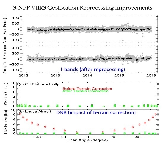
The NOAA operational VIIRS DNB geolocation at nighttime is monitored using point sources such as lights from oil platforms, power plants, gas flares, volcanoes, and bridges. Figure 4 shows an example of DNB nighttime geolocation error time series using DNB observations over the Oil Platform Holly point source from November 2015 to April 2017 (at sea level, http://ncc.nesdis.noaa.gov/VIIRS/VIIRSGeoErrors.php). Details about this site will be given in Section 5.1. DNB geolocation errors are calculated as distances between ground truth and observed latitudes and longitudes. Unlike the I-bands geolocation errors, DNB geolocation errors at different scan angles are not require to be adjusted to near-equivalent values due to the fact that S-NPP VIIRS DNB has near constant ground sample distance across the entire scan (see Figure 1b). Observed geolocations are centered on the oil platform, with mean bias about 0.5 pixel (0.375 km) and standard deviation about 0.2 km. Larger distance errors found in some cases may be caused by cloud contamination due to the difficulty of cloud detection at night. No significant scan angle dependency of DNB geolocation errors was observed, may due to the limitation of the nighttime point source based method used in this study.
4. Evaluating Reprocessing Improvements to the I-band/M-band Geolocation Products
4.1. Area of Interest Selection
The CPM program for NRT I-bands geolocation monitoring was used for I-band reprocessing improvements evaluation. Due to the huge volume of VIIRS data, reprocessing the entire SDR datasets (especially the geolocation data records), requires a significant amount of computing resources. In this study, we analyzed one year (2016) of global CPM results to identify a suitable area of interest (AOI) for fast geolocation product reprocessing improvement assessment. Figure 5a shows a small area over North Western Africa (Latitude: 16°N–32°N; Longitude: 16° to 7.6°W) that was selected based on the results of our analysis. There are 22 Landsat chips located within the region. Figure 5b show a sample Landsat chip selected. This region is distinguished by many clear days and large number of successful CPM events (defined by correlation coefficients >0.9) during all seasons. Most importantly, the area is small enough for quick VIIRS SDR product reprocessing.
4.2. I-Bands Geolocation Reprocessing Improvements
The NOAA operation VIIRS I-bands terrain corrected geolocation and band I1 radiance products over the study area from February 2012 to December 2016 were obtained from NOAA’s Comprehensive Large Array-Data Stewardship System (CLASS). Geolocation errors for the operational geolocation product were evaluated using CPM results. The errors at off nadir locations were converted to the nadir equivalent values using I-bands ground sample distance in the along scan and along track directions.
Figure 6 shows I-bands geolocation errors in the along scan and along track direction for the NOAA operational I-bands terrain-corrected geolocation. Dates for historical GEO PARAM LUT updates were also plotted. The background data points (gray color) show errors for individual CPM matching events; the solid line (black color) show averaged geolocation errors. Three short-term geolocation anomalies can be observed clearly: (1) before the initial instrument to spacecraft mounting matrix update on 23 February 2012, the geolocation errors are larger than 1 km; (2) the switch of SCE from Side B to Side A on 22 November 2012 causes ~400 m errors over the study area in the along scan direction; (3) the star tracker maintenance/re-alignment on 25 April 2013 causes errors of 25 m in both the along scan and along tract directions. The geolocation errors during the three periods estimated using the sample area are generally consistent with those estimated using global CPM datasets. The averaged geolocation errors prior to August 2013 are −47.1 ± 83.8 m (along scan) and −15.6 ± 43.6 m (along track). VIIRS geolocation products has been stable after the version 9 LUT update on 22 August 2013.
VIIRS geolocation products over the study area from February 2012 to 22 August 2013 were reprocessed using Algorithm Development Library (ADL) software version ADL_4.2_Mx8.11. No code change is required for VIIRS geolocation product reprocessing. Version 8 and version 9 of operational GEO PARAM LUTs were used for reprocessing before and after 25 April 2013 (15:20 UTC), respectively. Both the software and GEO PARAM LUTs used in this study are consistent with those used by the NOAA STAR reprocessing. No change in geometric calibration parameters after 22 August 2013 took place, therefore no reprocessing is needed in this study after this date.
Figure 7 shows VIIRS I-bands geolocation errors in the along scan and along track direction for the reprocessed I-bands terrain-corrected geolocation product. It can be observed that all three short-term calibration anomalies were successfully minimized after the reprocessing, with mean biases and standard deviations reduced to −23.3 ± 51.1 m (along scan) and −5.9 ± 37.7 m (along track). Geolocation errors increase slightly at off nadir locations, consistent with results based on global CPM results (see Section 2). Moreover, relatively larger residual bias (~−40 m) in the along scan direction from June–October 2012 was observed. We will continue to investigate this issue in the future.
5. Evaluating DNB Geolocation Product Reprocessing Improvements
Two major calibration improvements are expected in the reprocessed DNB geolocation product: (1) improvement due to DNB GEO PARAM LUT updates; (2) improvement due to the implementation of terrain correction for DNB. The DNB geolocation improvements due to GEO PARAM LUT updates are similar to those for I-bands, and will not be presented in this paper. Terrain correction was implemented from the beginning of the S-NPP mission for I-bands and M-band, however, it was not available for DNB until 22 May 2015. Terrain correction has no impacts over surfaces at sea level or at nadir; it improves geolocation accuracy at higher elevation surfaces and at larger scan angles. In this study, the improvement due to the terrain correction was quantified by comparing nighttime geolocation error over two point sources, one at sea level and the other one at high altitude.
5.1. Point Source Sites
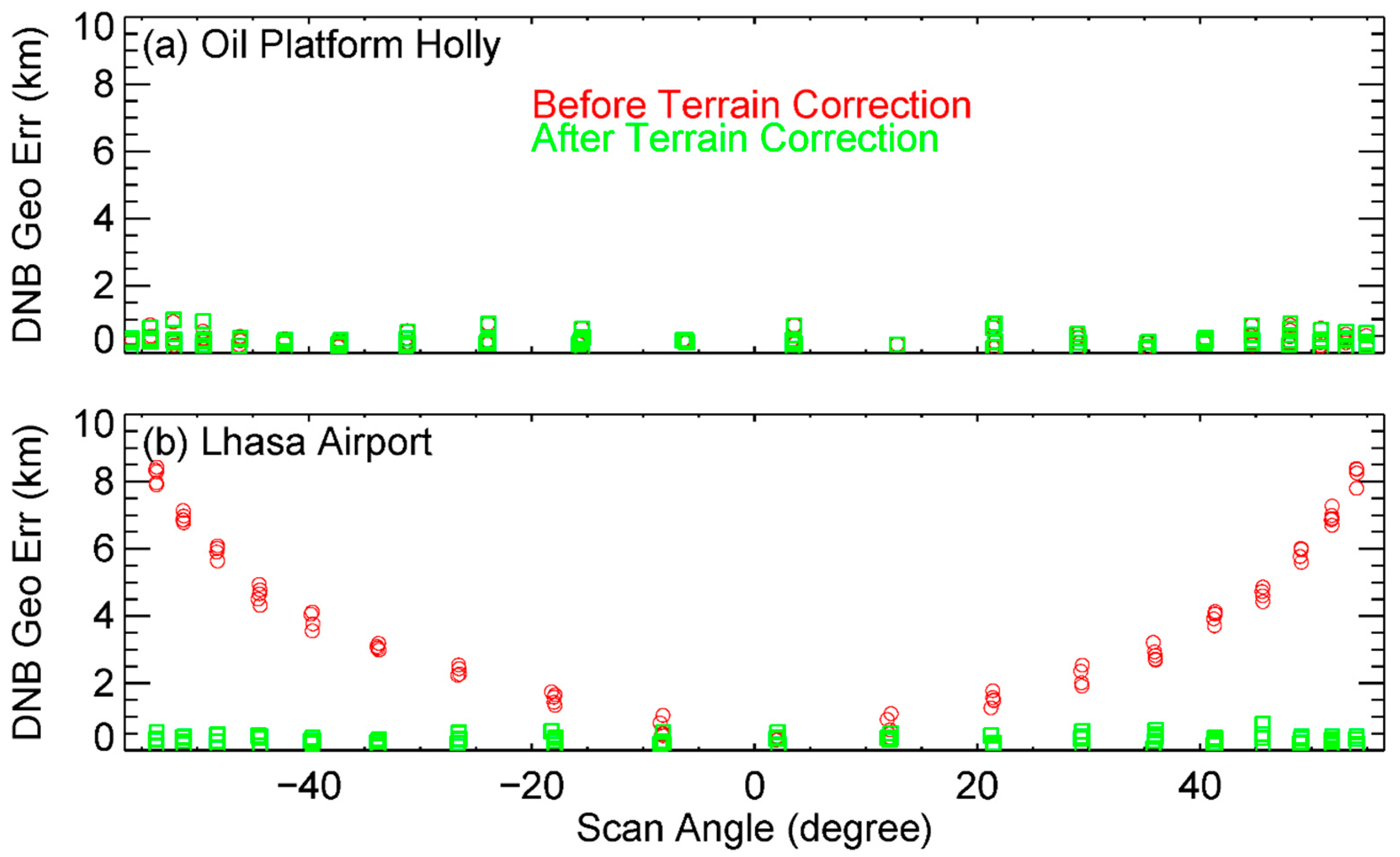
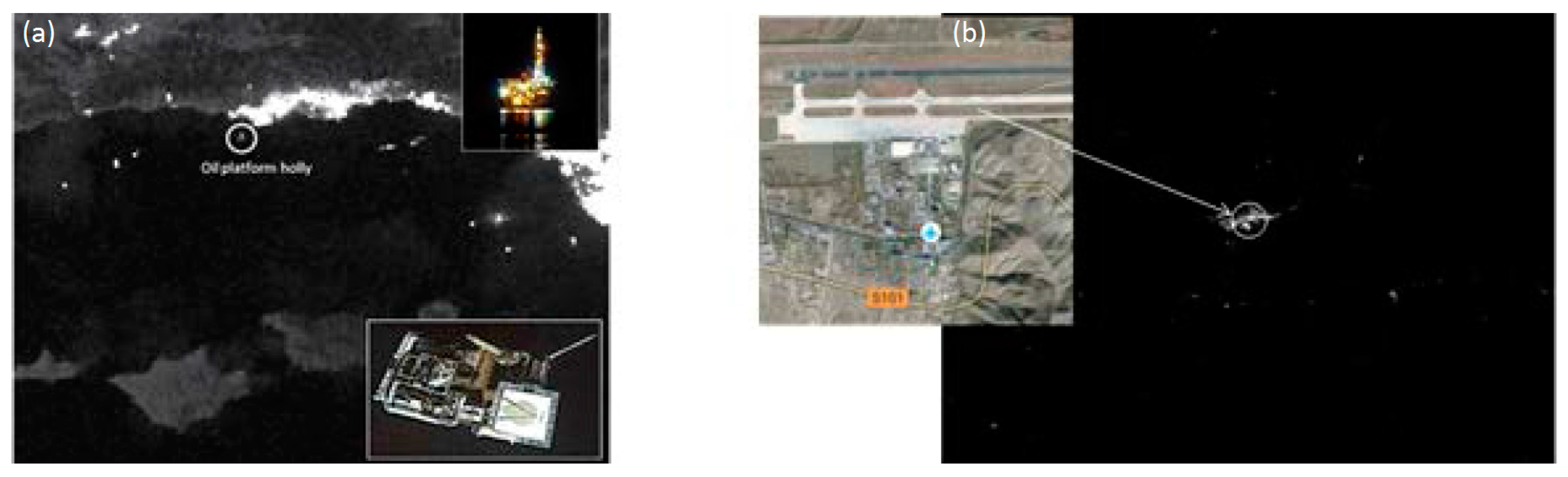
Two nighttime point sources were used to assess the DNB geolocation reprocessing improvement due to the implementation of terrain correction. The first point source is the Oil Platform Holly (latitude: 34.3898°N; longitude: 119.9065°W, at sea level, see Figure 8a), located near Los Angeles, CA. It is about 50 m long and 29 m wide over water. The lights appear to be always on at night and are relatively stable as a point source for DNB geolocation analysis. Although oil platforms have lights on overnight, their long-term stability is not well known. For example, some lights on the platform may be turned on and off at a given schedule. This may increase the uncertainties (to some extent) for geolocation validation. The second point source used by this study is the Lhasa Airport, Tibet, China (latitude: 29.2932°N; longitude 90.9006°E; elevation 3570 m above sea level, see Figure 8b). Differences between non-terrain corrected and terrin corrected geolocations over this high elevation site can be used to assess the DNB geolocation reprocessing improvement due to the implementation of terrain correction proir to 22 May 2015.
5.2. DNB Geolocation Improvement
Three months of NOAA operational DNB geolocation products (November 2015 to January 2016) over the two point sources were used to estimate improvements due to the implementing terrain correction to DNB geolocation. The data were obtained from NOAA STAR Central Data Repository, a short-term (4 months revolving) mirror site of the NOAA CLASS for S-NPP data. Geolocation errors were calculated as distances between the VIIRS observed and ground truth latitudes and longitudes for terrain corrected and non-terrain corrected geolocations over both sites.
Figure 9 compares geolocation errors over the Oil Platform Holly and Lhasa Airport sites. At sea level, DNB geolocation errors for the non-terrain corrected and terrain corrected geolocation products are very close to each other, with averaged geolocation error of ~0.5 pixel and standard deviation ~0.2 km. Moreover, geolocation errors are independent of scan angles, consistent with the fact that terrain correction only affects off-nadir observations with high elevations. Over the Lhasa Airport site, it can be observed that lack of terrain correction can introduce errors as large as ~9 km at high scan angles. After terrain correction, averaged geolocation error is reduced to ~0.5 pixel, comparable to the geolocation error over the Holly site. In addition, geolocation errors over the Lhasa Airport site become independent of scan angles after terrain correction.
6. Summary
S-NPP VIIRS SDR are being reprocessed at NOAA STAR using the latest coefficients and corrections in the algorithms to address the data inconsistency issues in the operational processing due to several major calibration changes since the launch of S-NPP satellite. Accurate VIIRS geolocation products are critical to other VIIRS data products and products from other instruments onboard the S-NPP satellite. This paper presents methods for assessing major improvements to the VIIRS geolocation products in the ongoing NOAA STAR reprocessing. In this study, we analyzed the history of VIIRS geometric calibration parameter updates to identify optimal versions of calibration parameters to account for geolocation errors in the early days of the mission. A sample area in North Western Africa was used to assess reprocessing improvements in the I-bands/M-bands geolocation products. Geolocation products over the region were reprocessed and I-bands/M-bands geolocation improvements were characterized by comparing geolocation errors before and after the reprocessing using the CPM program. Our results indicate that three short-term geolocation anomalies before the final GEO PARAM LUT update in August 2013 can be effectively reduced after reprocessing, with geolocation errors reduced from −47.1 ± 83.8 m to −23.3 ± 51.1 m (along scan) and from −15.6 ± 43.6 m to −5.9 ± 37.7 m (along track). Terrain correction will be implemented to the entire VIIRS DNB geolocation data record in the reprocessing. DNB reprocessing improvement due to the implementation of terrain correction was evaluated using nighttime observations over point sources at sea level and at high altitude. Our results show that terrain correction will reduce DNB geolocation errors for off nadir observation at high elevation locations from up to 9 km to ~0.5 pixel (0.375 km), comparable to the geolocation error over the sea level site. The reprocessed VIIRS geolocation dataset will be distributed online for end-users to access. The methodologies presented in this study will also be used to support J1 VIIRS, which will be launched in late 2017.
Acknowledgments
The manuscript contents are solely the opinions of the authors and do not constitute a statement of policy, decision, or position on behalf of NOAA or the U.S. government.
Author Contributions
Wenhui Wang and Yan Bai designed the study, developed methodology and software code, performed the analysis and wrote the manuscript. Changyong Cao and Slawomir Blonski contributed to the design of the study and provided technical oversight for the project.
Conflicts of Interest
The authors declare no conflict of interest.
References
- Cao, C.; De Luccia, F.J.; Xiong, X.; Wolfe, R.; Weng, F. Early on-orbit performance of the Visible Infrared Imaging Radiometer Suite onboard the Suomi National Polar-Orbiting Partnership (S-NPP) satellite. IEEE Trans. Geosci. Remote Sens. 2014, 52, 1142–1156. [Google Scholar] [CrossRef]
- Cao, C.; Xiong, J.; Blonski, S.; Liu, Q.; Uprety, S.; Shao, X.; Bai, Y.; Weng, F. Suomi NPP VIIRS sensor data record verification, validation, and long-term performance monitoring. J. Geophys. Res. 2013. [Google Scholar] [CrossRef]
- Cao, C.; Wang, W.; Blonski, S.; Zhang, B. Radiometric traceability diagnosis and bias correction for the Suomi NPP VIIRS long-wave infrared channels during blackbody unsteady states. J. Geophys. Res. 2017, 122, 5285–5297. [Google Scholar] [CrossRef]
- Blonski, S.; Cao, C. Suomi NPP VIIRS Reflective Solar Bands Operational Calibration Reprocessing. Remote Sens. 2015, 7, 15823. [Google Scholar] [CrossRef]
- Wang, W.; Cao, C.; Zhang, B.; Wang, L. Operational Correction and Validation of the VIIRS TEB Longwave Infrared Band Calibration Bias during Blackbody Temperature Changes. In Proceedings of the SPIE, San Diego, CA, USA, 21–23 August 2017. [Google Scholar]
- Choi, T.J.; Sun, J.; Zhang, B.; Wang, Z.; Cao, C.; Weng, F.; Wang, M. Suomi-NPP VIIRS initial reprocessing improvements and validations in the reflective solar bands. In Proceedings of the SPIE, San Diego, CA, USA, 21–23 August 2017. [Google Scholar]
- Wang, L.; Tremblay, D.A.; Han, Y.; Esplin, M.; Hagan, D.E.; Predina, J.; Suwinski, L.; Jin, X.; Chen, Y. Geolocation assessment for CrIS sensor data records. J. Geophys. Res. 2013, 118, 12690–12704. [Google Scholar] [CrossRef]
- Cao, C.; Xiong, X.J.; Wolfe, R.; DeLuccia, F.; Liu, Q.M.; Blonski, S.; Lin, G.G.; Nishihama, M.; Pogorzala, D.; Oudrari, H.; et al. Visible Infrared Imaging Radiometer Suite (VIIRS) Sensor Data Record (SDR) User’s Guide Version 1.2; National Oceanic and Atmospheric Administration (NOAA): College Park, MD, USA, 2013.
- Wolfe, R.E.; Lin, G.; Nishihama, M.; Tewari, K.P.; Tilton, J.C.; Isaacman, A.R. Suomi NPP VIIRS prelaunch and on-orbit geometric calibration and characterization. J. Geophys. Res. 2013, 118. [Google Scholar] [CrossRef]
- VIIRS ATBD. Joint Polar Satellite System (JPSS) VIIRS Radiometric Calibration Algorithm Theoretical Basis Document; NOAA/NESDIS/STAR: College Park, MD, USA, 2013.
- Lin, G.; Wolfe, R.E.; Yin, Z.; Tan, B.; Dellomo, J.; Tilton, J.C. Suomi NPP VIIRS geolocation update. In Proceedings of the NOAA STAR VIIRS SDR Bi-Weekly Teleconference, College Park, MD, USA, 24 February 2016. [Google Scholar]
- Liao, L.B.; Weiss, S.; Mills, S.; Hauss, B. Suomi NPP VIIRS day-night band on-orbit performance. J. Geophys. Res. 2013, 118. [Google Scholar] [CrossRef]
- Wolfe, R.E.; Lin, G.; Yin, Z.; Nishihama, M.; Tan, B.; Tilton, J.C. Suomi NPP VIIRS geolocation performance and improvements. In Proceedings of the JPSS 2014 Annual Science Team Meeting, College Park, MD, USA, 12–16 May 2014. [Google Scholar]
- Wolfe, R.E.; Nishihama, M.; Fleig, A.J.; Kuyper, J.A.; Roy, D.P.; Storey, J.C.; Patt, F.S. Achieving sub-pixel geolocation accuracy in support of MODIS land science. Remote Sens. Environ. 2002, 83, 31–49. [Google Scholar] [CrossRef]
- Lin, G.; Wolfe, R.E.; Dellomo, J.; Yin, Z.; Tan, B.; Tilton, J.C. VIIRS geospatial calibration for SNPP, J1 and beyond. In Proceedings of the NOAA STAR JPSS Annual Science Team Meeting, College Park, MD, USA, 8–12 August 2016. [Google Scholar]
- Lin, G.; NASA VCST, Greenbelt, MD, USA. Personal communication, 2017.
Figure 1.
S-NPP VIIRS ground sample distances (GSD) in the along scan and along track directions for (a) I-bands; (b) Day-Night-Band (DNB).
Figure 1.
S-NPP VIIRS ground sample distances (GSD) in the along scan and along track directions for (a) I-bands; (b) Day-Night-Band (DNB).
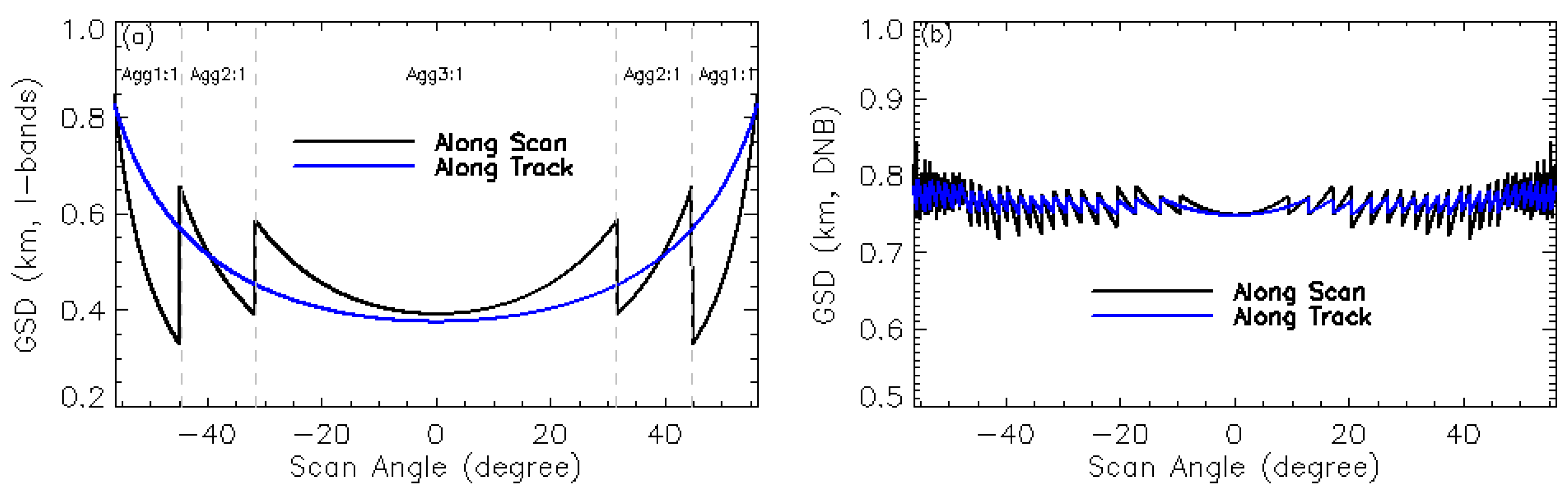
Figure 2.
Global distributions of Landsat chips in the NASA control point matching (CPM) chip library.
Figure 2.
Global distributions of Landsat chips in the NASA control point matching (CPM) chip library.
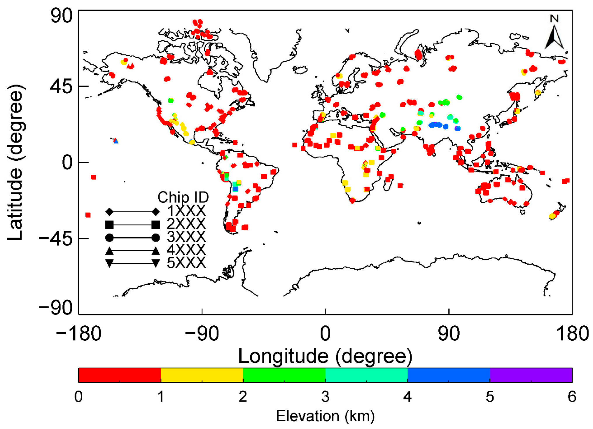
Figure 3.
NRT VIIRS I-bands geolocation error time series in the along scan (top) and along track (bottom) directions since February 2017.
Figure 3.
NRT VIIRS I-bands geolocation error time series in the along scan (top) and along track (bottom) directions since February 2017.
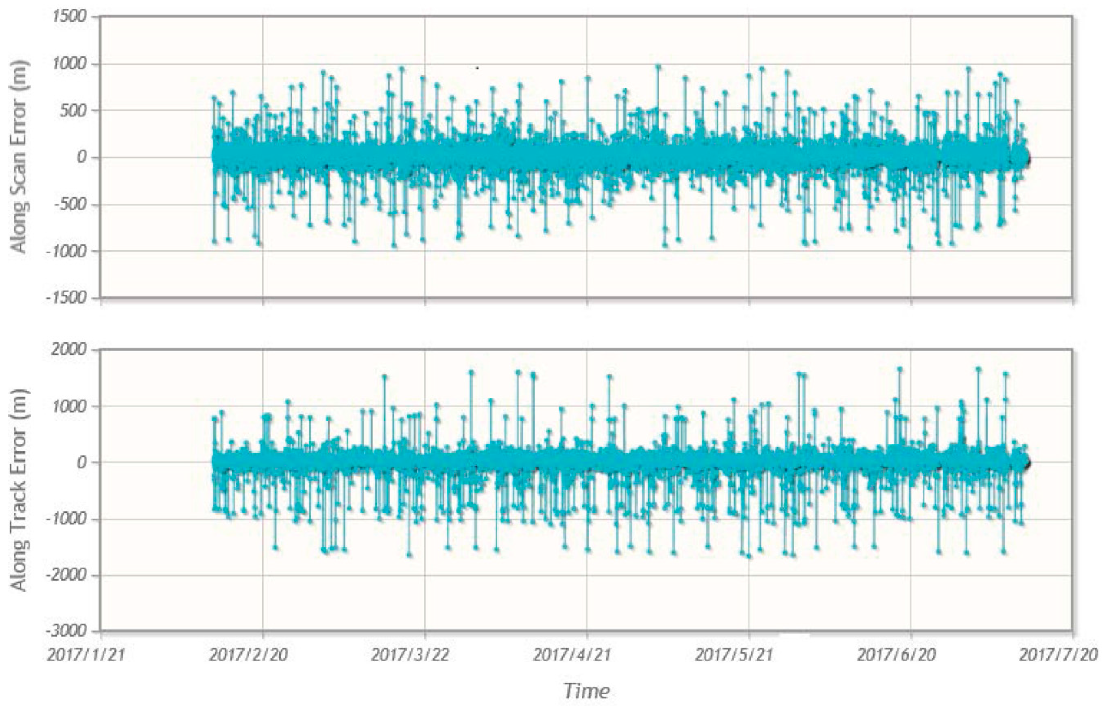
Figure 4.
VIIRS DNB geolocation errors at the Oil Platform Holly site.
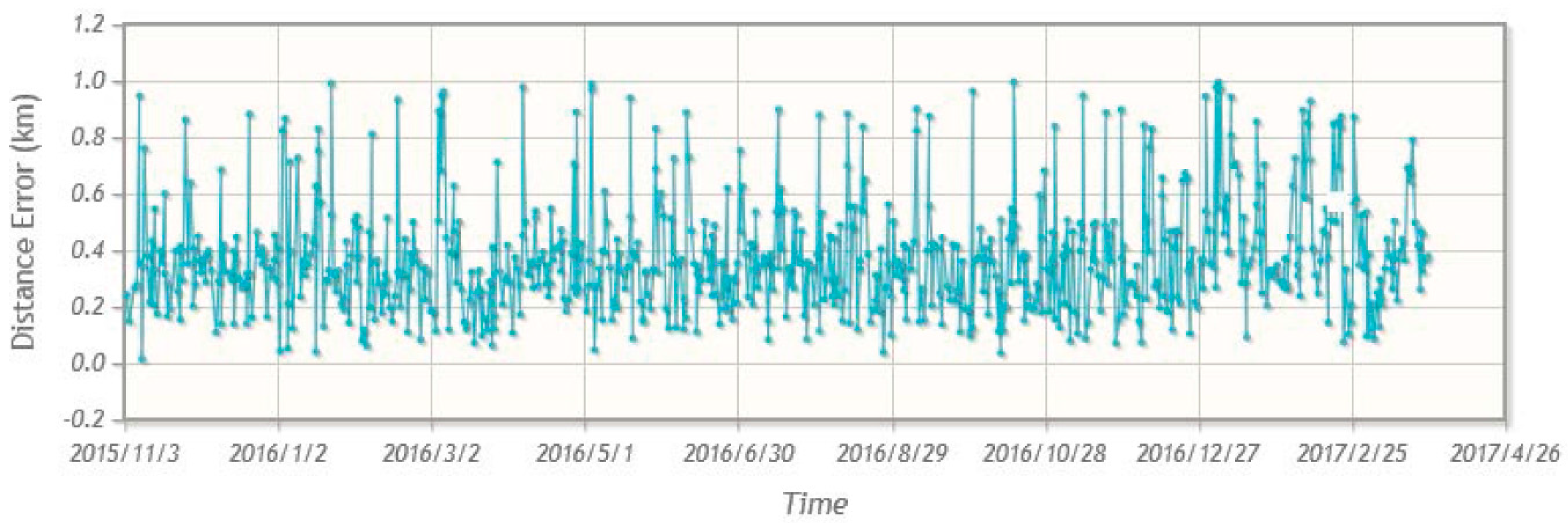
Figure 5.
(a) Area of interest identified for I-bands geolocation improvement assessment; (b) sample Landsat chip within the area of interest.
Figure 5.
(a) Area of interest identified for I-bands geolocation improvement assessment; (b) sample Landsat chip within the area of interest.
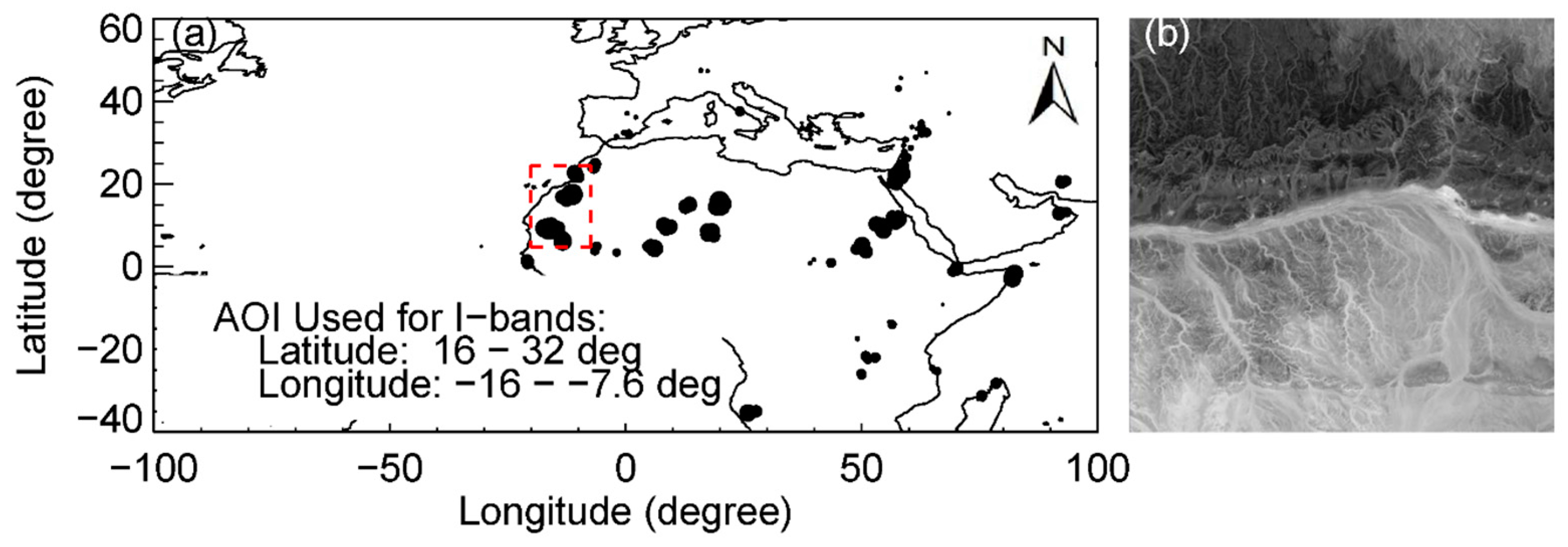
Figure 6.
I-bands geolocation errors in the along scan (top) and along track direction (bottom) for the NOAA operational I-bands terrain-corrected geolocation product.
Figure 6.
I-bands geolocation errors in the along scan (top) and along track direction (bottom) for the NOAA operational I-bands terrain-corrected geolocation product.
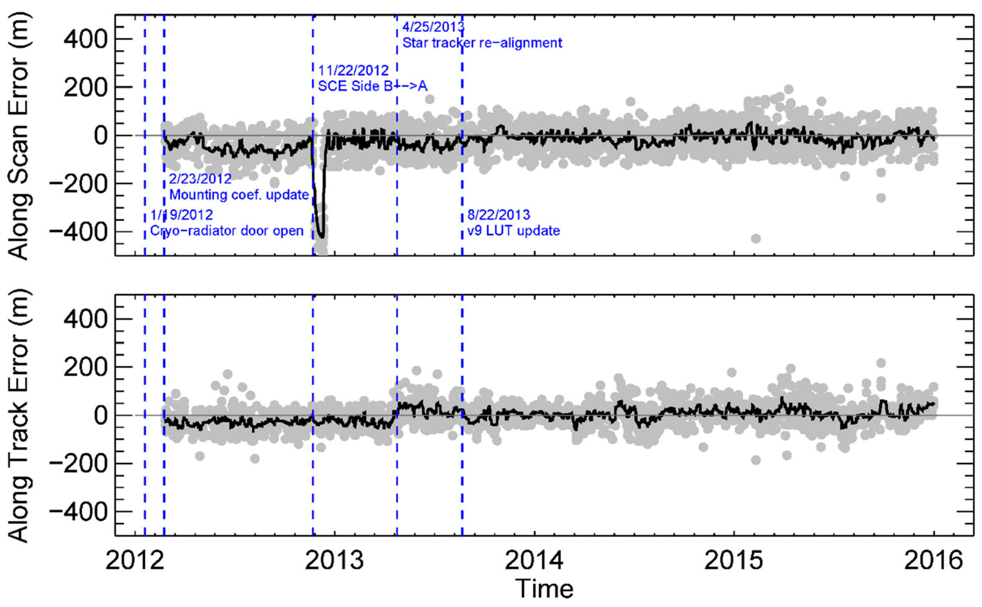
Figure 7.
I-bands geolocation errors in the along scan (top) and along track direction (bottom) for the reprocessed I-bands terrain-corrected geolocation product.
Figure 7.
I-bands geolocation errors in the along scan (top) and along track direction (bottom) for the reprocessed I-bands terrain-corrected geolocation product.
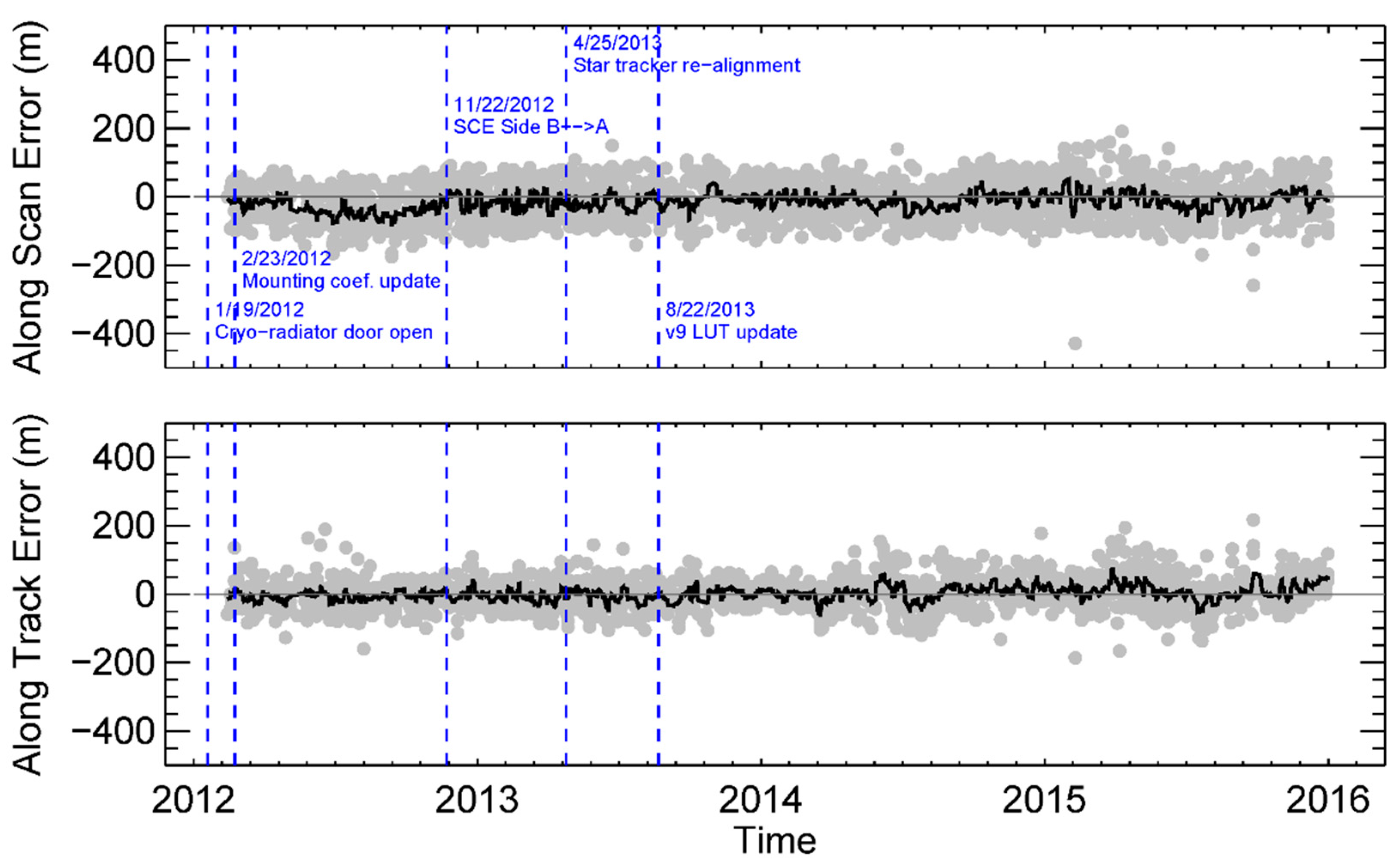
Figure 8.
Two DNB nighttime point sources: (a) the Oil Platform Holly; (b) the Lhasa airport.

Figure 9.
Nighttime DNB geolocation errors over (a) the Oil Platform Holly and (b) the Lhasa Airport sites.
Figure 9.
Nighttime DNB geolocation errors over (a) the Oil Platform Holly and (b) the Lhasa Airport sites.

Table 1.
Summary of the Visible and Infrared Imaging Radiometer Suite (VIIRS) geolocation products.
| Product Short Name | Spatial Resolution | Description | |
|---|---|---|---|
| I-bands | GIMGO | 375 m at nadir | Non-terrain corrected geolocation for I-bands |
| GITCO | 375 m at nadir | Terrain corrected geolocation for I-bands | |
| M-bands | GMODO | 750 m at nadir | Non-terrain corrected geolocation for M-bands |
| GMTCO | 750 m at nadir | Terrain corrected geolocation for M-bands | |
| DNB | GDNBO | 750 m across the entire scan | Non-terrain corrected and terrain corrected (since 22 May 2015) geolocation for DNB |
Table 2.
S-NPP VIIRS geometric parameter look-up table update history.
| Version | Effectivity Date | Notes |
|---|---|---|
| 0 | 11/8/2011–12/9/2011 | Initial prelaunch version. |
| 1 | 12/9/2011–2/23/2012 | Final prelaunch version. Cryo-radiator door opened on 1/19/2012. |
| 2 | I&M: 2/23/2012–12/11/2012 DNB: 2/23/2012–3/29/2012 | Initial instrument to spacecraft mounting matrix update. Removed bias ~1.3 km in I-bands and M-bands. |
| 3 | DNB: 3/29/2012–12/11/2012 | Adjusting DNB FPA center to reduce offset in DNB geolocation; removed bias ~3 km. |
| 4 | Not implemented | Initial version of LUTs prepared for SCE B → A switching for reducing HAM and RTA synchronization errors. |
| 5 | I&M: 12/11/2012–4/18/2013 | Telemetry polynomial coefficients appropriate to both sides A and B are in the corresponding field: Removed bias ~300 m after SCE was switched from Side B to Side Ae on 11/22/2012. |
| 6 | DNB: 12/11/2012–2/14/2013 | This version updated the poly_coef_tel field for SCE Side A [9]. |
| 7 | DNB: 2/14/2013–4/18/2013 | Additional analysis of SCE Side A data to optimize correction for both electronic sides, removed scan dependent biases. |
| 8 | 4/18/2013–8/22/2013 | Fine tune for reducing residual error versus scan angle [9]. |
| 9 | 8/22/2013–present | Star tracker re-alignment occurred on 4/25/2013 and caused bias ~25 m. This update ddjusted instrument to spacecraft mounting matrix and removed the ~25 m bias. |
© 2017 by the authors. Licensee MDPI, Basel, Switzerland. This article is an open access article distributed under the terms and conditions of the Creative Commons Attribution (CC BY) license (http://creativecommons.org/licenses/by/4.0/).
Share and Cite
MDPI and ACS Style
Wang, W.; Cao, C.; Bai, Y.; Blonski, S.; Schull, M.A. Assessment of the NOAA S-NPP VIIRS Geolocation Reprocessing Improvements. Remote Sens. 2017, 9, 974. https://doi.org/10.3390/rs9100974
AMA Style
Wang W, Cao C, Bai Y, Blonski S, Schull MA. Assessment of the NOAA S-NPP VIIRS Geolocation Reprocessing Improvements. Remote Sensing. 2017; 9(10):974. https://doi.org/10.3390/rs9100974
Chicago/Turabian StyleWang, Wenhui, Changyong Cao, Yan Bai, Slawomir Blonski, and Mitchell A. Schull. 2017. "Assessment of the NOAA S-NPP VIIRS Geolocation Reprocessing Improvements" Remote Sensing 9, no. 10: 974. https://doi.org/10.3390/rs9100974
Note that from the first issue of 2016, this journal uses article numbers instead of page numbers. See further details here.