
Urban Land-Cover Dynamics in Arid China Based on High-Resolution Urban Land Mapping Products


 ,
,  ,
,
Abstract
:
1. Introduction
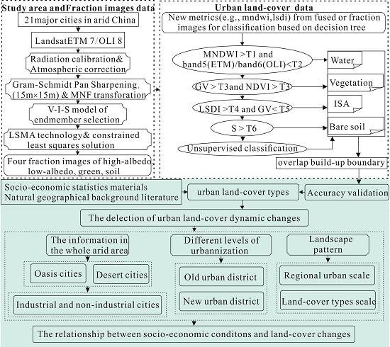
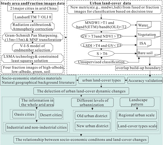
2. Materials and Methods
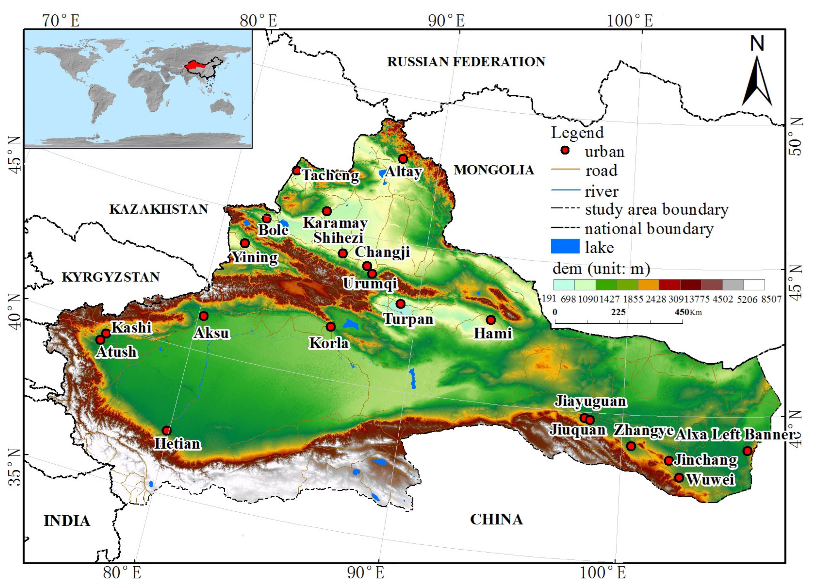
2.1. Study Area
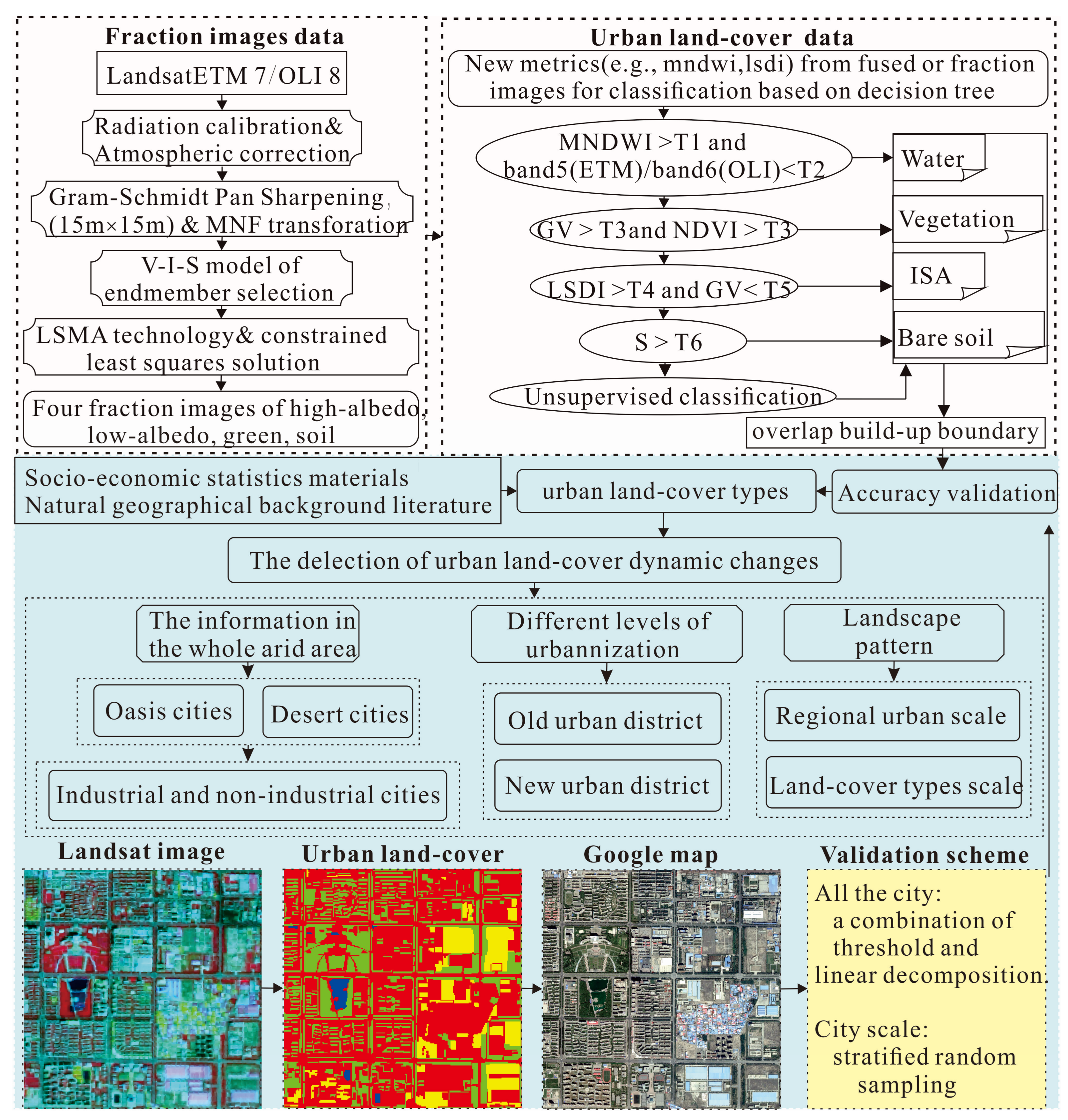
2.2. Methods
2.2.1. Data Collection and Pre-Processing
2.2.2. Data Fusion and Extraction of Fraction Images
2.2.3. Urban Land-Cover Classification and Type Division of Cities
2.2.4. Accuracy Evaluation
2.2.5. Change Detection Analysis
2.2.6. Landscape Pattern Analysis
2.2.7. Impacts of Economic Conditions on Urban Land-Cover Change
3. Results
3.1. Analysis of Urban Land Cover Classification Results
3.2. Analysis of Urban Land-Cover Changes between 2000 and 2014
3.2.1. Dynamic Characteristics of Urban Land-Cover in Arid Region of China
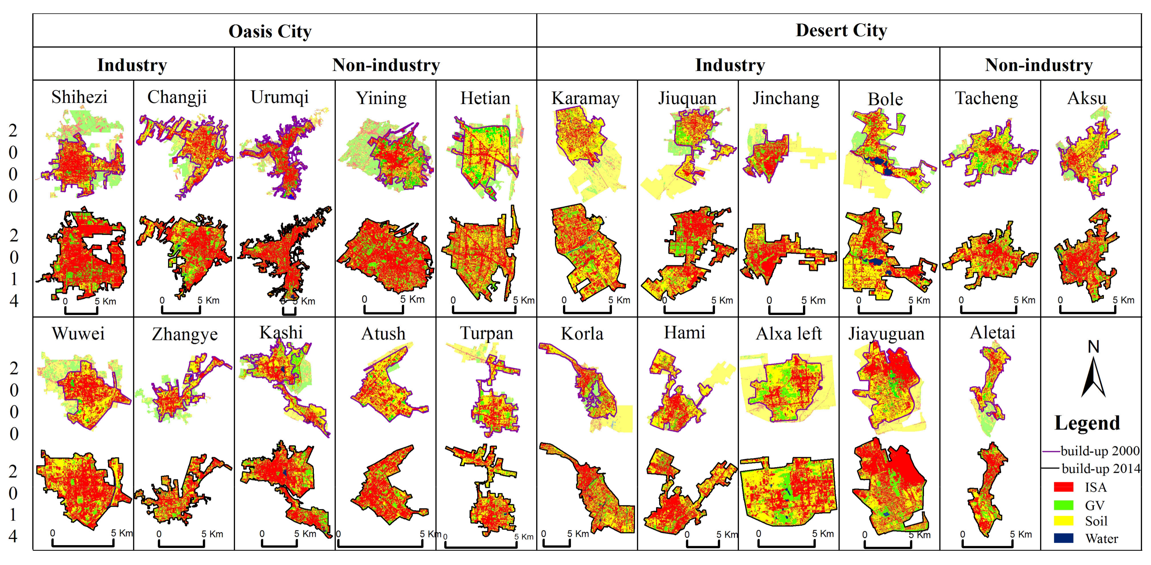
3.2.2. Changes of Spatial Distribution and Land-Cover in Different City Types
3.2.3. Changes of Land-Cover Transfer in Different Urbanization Levels
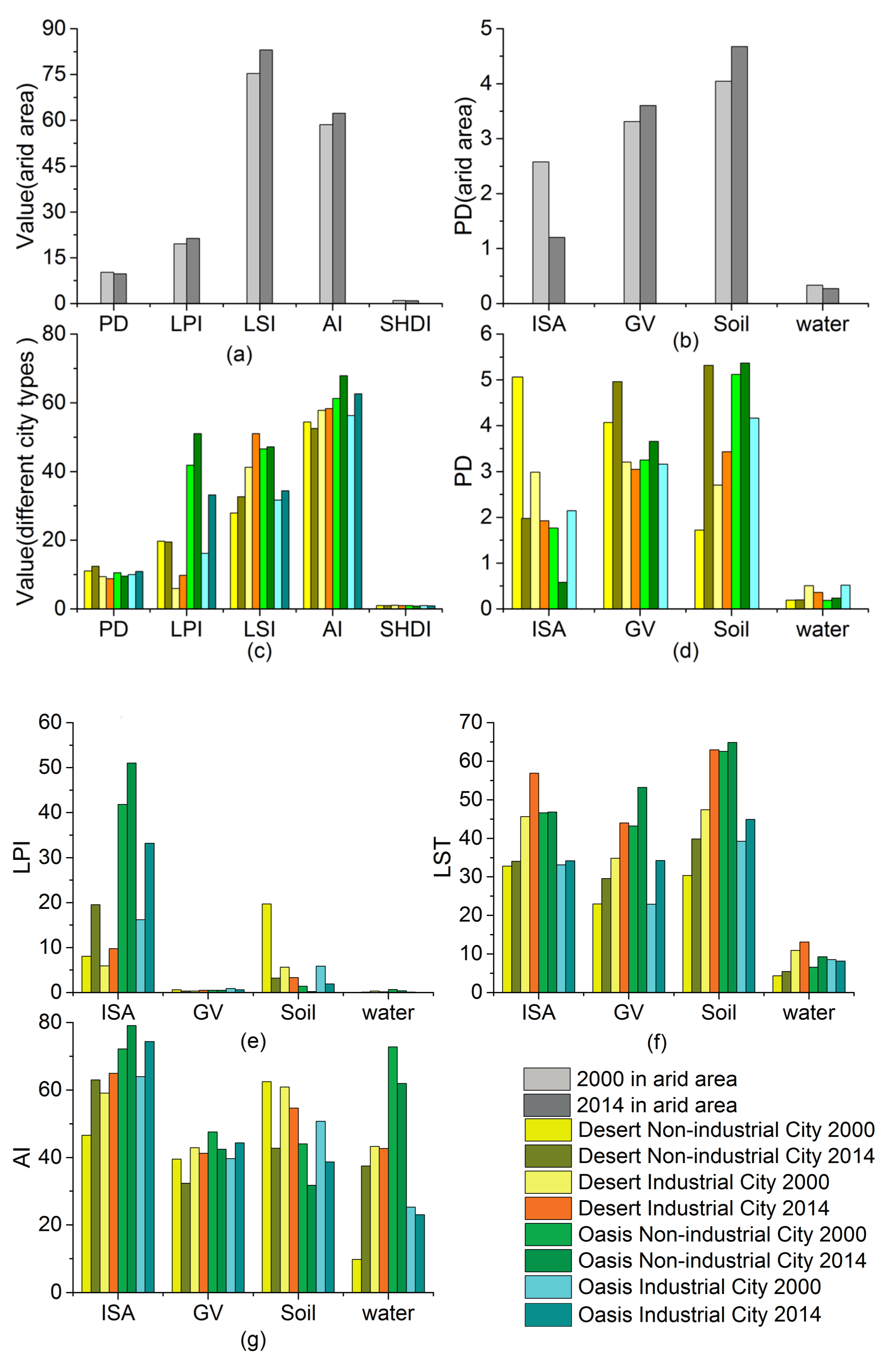
3.2.4. Patterns of Landscape Change
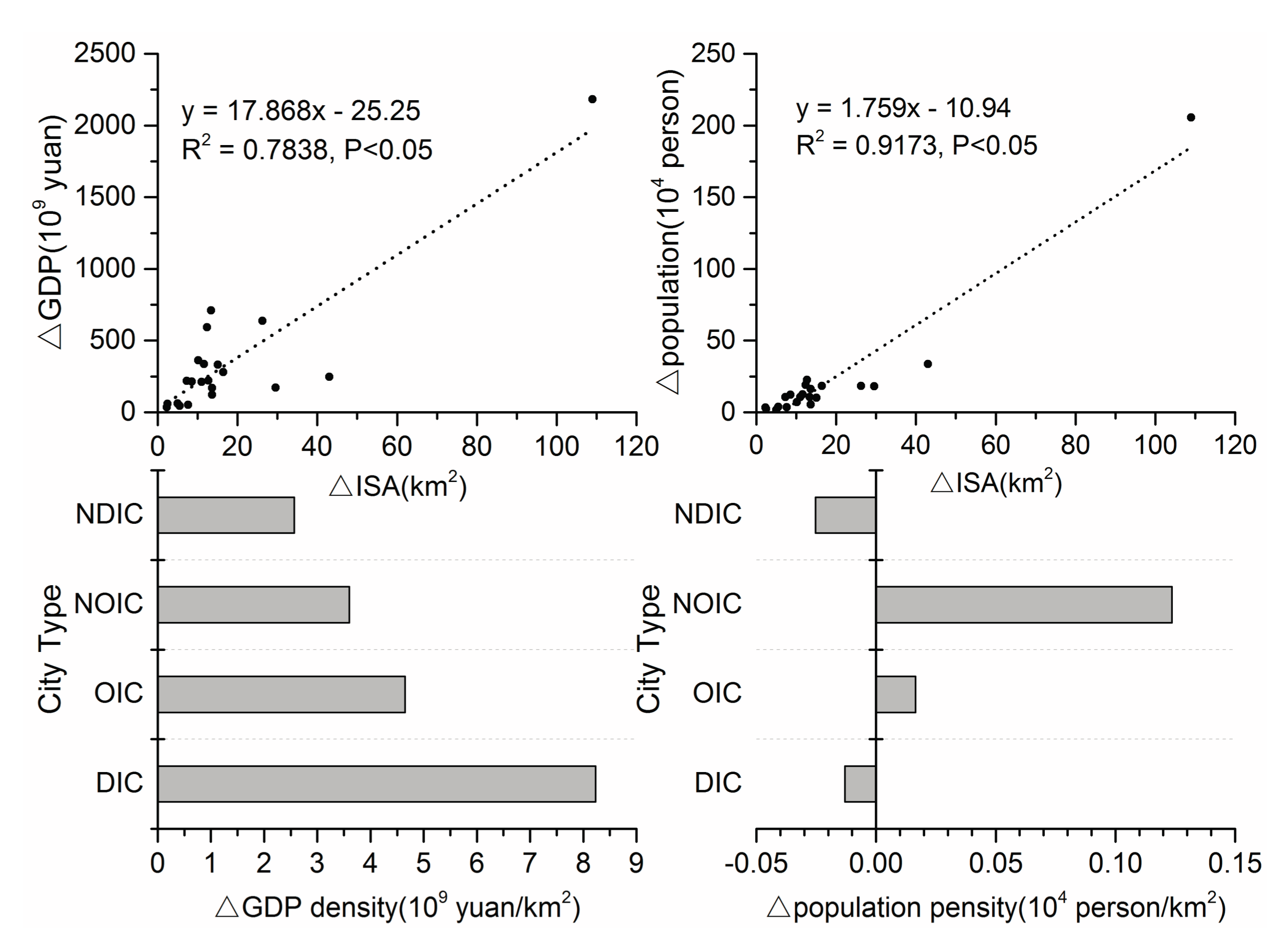
3.3. Analysis of the Relationship between Socio-Economic Conditions and Urban Land-Cover Changes
4. Discussion
4.1. Comparison of Urban Land-Cover Changes among Different Regions
4.2. The Urbanization Characterized by Expansion of ISA and Reduction of Bare Soil
4.3. Increasing Harmonization of Urbanization and Greening in Arid China
4.4. Environmental Effects
5. Conclusions
Acknowledgments
Author Contributions
Conflicts of Interest
References
- Grimm, N.B.; Faeth, S.H.; Golubiewski, N.E.; Redman, C.L.; Wu, J.; Bai, X.; Briggs, J.M. Global change and the ecology of cities. Science 2008, 319, 756–760. [Google Scholar] [CrossRef] [PubMed]
- Lutz, W.; Sanderson, W.C.; Scherbov, S. The end of world population growth. Nature 2001, 412, 543–545. [Google Scholar] [CrossRef] [PubMed]
- Seto, K.C.; Fragkias, M.; Güneralp, B.; Reilly, M.K. A meta-analysis of global urban land expansion. PLoS ONE 2011, 6, e23777. [Google Scholar] [CrossRef] [PubMed]
- Schneider, A. Monitoring land cover change in urban and peri-urban areas using dense time stacks of Landsat satellite data and a data mining approach. Remote Sens. Environ. 2012, 124, 689–704. [Google Scholar] [CrossRef]
- Seto, K.C.; Güneralp, B.; Hutyra, L.R. Global forecasts of urban expansion to 2030 and direct impacts on biodiversity and carbon pools. Proc. Natl. Acad. Sci. USA 2012, 109, 16083–16088. [Google Scholar] [CrossRef] [PubMed]
- Davies, Z.G.; Edmondson, J.L.; Heinemeyer, A.; Leake, J.R; Gaston, K.J. Mapping an urban ecosystem service: Quantifying above-ground carbon storage at a city-wide scale. J. Appl. Ecol. 2011, 48, 1125–1134. [Google Scholar]
- Seto, K.C.; Shepherd, J.M. Global urban land-use trends and climate impacts. Curr. Opin. Environ. Sustain. 2009, 1, 89–95. [Google Scholar] [CrossRef]
- Lee, J.G.; Heaney, J.P. Estimation of urban imperviousness and its impacts on storm water systems. J. Water Resour. Plan. Manag. 2003, 129, 419–426. [Google Scholar] [CrossRef]
- Wu, J.J. Making the case for landscape ecology an effective approach to urban sustainability. Landsc. J. 2008, 27, 41–50. [Google Scholar] [CrossRef]
- Kuang, W.; Liu, J.; Zhang, Z.; Lu, D.; Xiang, B. Spatiotemporal dynamics of impervious surface areas across China during the early 21st century. Chin. Sci. Bull. 2013, 58, 1691–1701. [Google Scholar] [CrossRef]
- Zhang, Y.; Odeh, I.O.; Han, C. Bi-temporal characterization of land surface temperature in relation to impervious surface area, NDVI and NDBI, using a sub-pixel image analysis. Int. J. Appl. Earth Obs. Geoinf. 2009, 11, 256–264. [Google Scholar] [CrossRef]
- Amiri, R.; Weng, Q.; Alimohammadi, A.; Alavipanah, S.K. Spatial–temporal dynamics of land surface temperature in relation to fractional vegetation cover and land use/cover in the Tabriz urban area, Iran. Remote Sens. Environ. 2009, 113, 2606–2617. [Google Scholar] [CrossRef]
- Kuang, W.; Chi, W.; Lu, D.; Dou, Y. A comparative analysis of megacity expansions in China and the US: Patterns, rates and driving forces. Landsc. Urban Plan. 2014, 132, 121–135. [Google Scholar] [CrossRef]
- Li, J.; Song, C.; Cao, L.; Zhu, F.; Meng, X.; Wu, J. Impacts of landscape structure on surface urban heat islands: A case study of Shanghai, China. Remote Sens. Environ. 2011, 115, 3249–3263. [Google Scholar] [CrossRef]
- Wu, J.; Desertification, R.R. Plant Sciences for Students; Macmillan Reference: New York, NY, USA, 2001. [Google Scholar]
- Lin, M.-L.; Chen, C.-W. Application of fuzzy models for the monitoring of ecologically sensitive ecosystems in a dynamic semi-arid landscape from satellite imagery. Eng. Comput. 2010, 27, 5–19. [Google Scholar] [CrossRef]
- Kepner, W.G.; Watts, C.J.; Edmonds, C.M.; Maingi, J.K.; Marsh, S.E.; Luna, G. A landscape approach for detecting and evaluating change in a semi-arid environment. In Monitoring Ecological Condition in the Western United States; Springer: Berlin, Germany, 2000; pp. 179–195. [Google Scholar]
- Zhang, C.; Chen, Y.; Lu, D. Mapping the land-cover distribution in arid and semiarid urban landscapes with Landsat Thematic Mapper imagery. Int. J. Remote Sens. 2015, 36, 4483–4500. [Google Scholar] [CrossRef]
- Zhang, Y.; Yang, D.; Zhang, X.; Dong, W.; Zhang, X. Regional structure and spatial morphology characteristics of oasis urban agglomeration in arid area—A case of urban agglomeration in northern slope of Tianshan Mountains, Northwest China. Chin. Geogr. Sci. 2009, 19, 341–348. [Google Scholar] [CrossRef]
- Myint, S.W.; Okin, G.S. Modelling land-cover types using Multiple Endmember Spectral Mixture Analysis in a desert city. Int. J. Remote Sens. 2009, 30, 2237–2257. [Google Scholar] [CrossRef]
- Li, X.; Myint, S.W.; Zhang, Y.; Galletti, C.; Zhang, X.; Turner, B.L. Object-based land-cover classification for metropolitan Phoenix, Arizona, using aerial photography. Int. J. Appl. Earth Obs. Geoinf. 2014, 33, 321–330. [Google Scholar] [CrossRef]
- Wulder, M.A.; Masek, J.G.; Cohen, W.B.; Loveland, T.R.; Woodcock, C.E. Opening the archive: How free data has enabled the science and monitoring promise of Landsat. Remote Sens. Environ. 2012, 122, 2–10. [Google Scholar] [CrossRef]
- Yan, Y.; Zhang, C.; Hu, Y.F.; Kuang, W.H. Urban Land-Cover Change and Its Impact on the Ecosystem Carbon Storage in a Dryland City. Remote Sens. 2016, 8, 6. [Google Scholar] [CrossRef]
- Lu, D.; Moran, E.; Batistella, M. Linear mixture model applied to Amazonian vegetation classification. Remote Sens. Environ. 2003, 87, 456–469. [Google Scholar] [CrossRef]
- Wu, C.; Murray, A.T. Estimating impervious surface distribution by spectral mixture analysis. Remote Sens. Environ. 2003, 84, 493–505. [Google Scholar] [CrossRef]
- Chi, W.; Shi, W.; Kuang, W. Spatio-temporal characteristics of intra-urban land cover in the cities of China and USA from 1978 to 2010. J. Geogr. Sci. 2015, 25, 3–18. [Google Scholar] [CrossRef]
- Guo, W.; Lu, D.; Wu, Y.; Zhang, J. Mapping Impervious Surface Distribution with Integration of SNNP VIIRS-DNB and MODIS NDVI Data. Remote Sens. 2015, 7, 12459–12477. [Google Scholar] [CrossRef]
- Lu, D.; Moran, E.; Hetrick, S. Detection of impervious surface change with multitemporal Landsat images in an urban–rural frontier. ISPRS J. Photogramm. Remote Sens. 2011, 66, 298–306. [Google Scholar] [CrossRef] [PubMed]
- Stefanov, W.L.; Ramsey, M.S.; Christensen, P.R. Monitoring urban land cover change: An expert system approach to land cover classification of semiarid to arid urban centers. Remote Sens. Environ. 2001, 77, 173–185. [Google Scholar] [CrossRef]
- Li, B.; Chen, Y.; Shi, X. Why does the temperature rise faster in the arid region of northwest China? J. Geophys. Res. Atmos. 2012, 117. [Google Scholar] [CrossRef]
- Wang, H.; Chen, Y.; Chen, Z. Spatial distribution and temporal trends of mean precipitation and extremes in the arid region, northwest of China, during 1960–2010. Hydrol. Process. 2013, 27, 1807–1818. [Google Scholar] [CrossRef]
- Module, F. Atmospheric Correction Module: QUAC and FLAASH User’s Guide. Version 2009, 4, 44. [Google Scholar]
- Bernstein, L.; Adler-Golden, S.; Sundberg, R.; Ratkowski, A. Improved Reflectance Retrieval from Hyper-and Multispectral Imagery without Prior Scene or Sensor Information. In Remote Sensing of Clouds and the Atmosphere XI; SPIE—International Society for Optics and Photonics: Bellingham, WA, USA, 2006; pp. 63622P–63628P. [Google Scholar]
- Liu, J.; Liu, M.; Zhuang, D.; Zhang, Z.; Deng, X. Study on spatial pattern of land-use change in China during 1995–2000. Sci. China Ser. D Earth Sci. 2003, 46, 373–384. [Google Scholar]
- Liu, J.Y.; Zhang, Z.X.; Zhuang, D.F.; Wang, Y.M.; Zhou, W.C.; Zhang, S.W.; Li, R.D.; Jiang, N.; Wu, S.X. A study on the spatial-temporal dynamic changes of land-useand driving forces analyses of China in the 1990s. Geogr. Res. 2003, 22, 1–12. [Google Scholar]
- Lu, D.; Li, G.; Kuang, W.; Moran, E. Methods to extract impervious surface areas from satellite images. Int. J. Digit. Earth 2014, 7, 93–112. [Google Scholar] [CrossRef]
- Lu, D.; Li, G.; Moran, E.; Batistella, M.; Freitas, C.C. Mapping impervious surfaces with the integrated use of Landsat Thematic Mapper and radar data: A case study in an urban–rural landscape in the Brazilian Amazon. ISPRS J. Photogramm. Remote Sens. 2011, 66, 798–808. [Google Scholar] [CrossRef]
- Ehlers, M.; Klonus, S.; Johan Åstrand, P.; Rosso, P. Multi-sensor image fusion for pansharpening in remote sensing. Int. J. Image Data Fusion 2010, 1, 25–45. [Google Scholar] [CrossRef]
- Han-qiu, X. A Study on Information Extraction of Water Body with the Modified Normalized Difference Water Index (MNDWI). J. Remote Sens. 2005, 5, 589–595. [Google Scholar]
- Zhang, C.; Tian, H.; Chen, G.; Chappelka, A.; Xu, X.; Ren, W.; Hui, D.; Liu, M.; Lu, C.; Pan, S. Impacts of urbanization on carbon balance in terrestrial ecosystems of the Southern United States. Environ. Pollut. 2012, 164, 89–101. [Google Scholar] [CrossRef] [PubMed]
- Fan, F.; Fan, W.; Weng, Q. Improving Urban Impervious Surface Mapping by Linear Spectral Mixture Analysis and Using Spectral Indices. Can. J. Remote Sens. 2015, 41, 577–586. [Google Scholar] [CrossRef]
- Adams, J. Classification of multispectral images based on fractions of endmembers: Application to land-cover change in the Brazilian Amazon. Remote Sens. Environ. 1995, 52, 137–154. [Google Scholar] [CrossRef]
- Lu, D.; Weng, Q. Use of impervious surface in urban land-use classification. Remote Sens. Environ. 2006, 102, 146–160. [Google Scholar] [CrossRef]
- Zurlini, G.; Riitters, K.H.; Zaccarelli, N.; Petrosillo, I. Patterns of disturbance at multiple scales in real and simulated landscapes. Landsc. Ecol. 2007, 22, 705–721. [Google Scholar] [CrossRef]
- Spatial Pattern Analysis Program for Categorical and Continuous Maps. Available online: http://www.umass.edu/landeco/research/fragstats/documents/fragstats.help.4.2.pdf (accessed on 21 April 2015).
- Aina, Y.A.; Parvez, I.M.; Balogun, A.-L. Examining the Effect of Land Use on the Spatiotemporal Dynamics of Urban Temperature in an Industrial City: A Landsat Imagery Analysis; Springer: Berlin, Germany, 2017; pp. 3–15. [Google Scholar]
- Smits, P.C.; Dellepiane, S.G.; Schowengerdt, R.A. Quality assessment of image classification algorithms for land-cover mapping: A review and a proposal for a cost-based approach. Int. J. Remote Sens. 1999, 20, 1461–1486. [Google Scholar] [CrossRef]
- Shuster, W.; Bonta, J.; Thurston, H.; Warnemuende, E.; Smith, D. Impacts of impervious surface on watershed hydrology: A review. Urban Water J. 2005, 2, 263–275. [Google Scholar] [CrossRef]
- Xiao, R.-B.; Ouyang, Z.-Y.; Zheng, H.; Li, W.-F.; Schienke, E.W.; Wang, X.-K. Spatial pattern of impervious surfaces and their impacts on land surface temperature in Beijing, China. J. Environ. Sci. 2007, 19, 250–256. [Google Scholar] [CrossRef]
- Liu, J.Y.; Kuang, W.H.; Zhang, Z.X.; Xu, X.L.; Qin, Y.W.; Ning, J.; Zhou, W.C.; Zhang, S.W.; Li, R.D.; Yan, C.Z.; et al. Spatiotemporal characteristics, patterns, and causes of land-use changes in China since the late 1980s. J. Geogr. Sci. 2014, 24, 195–210. [Google Scholar] [CrossRef]
- Cheng, G. Evolution of the Concept of Carrying Capacity and the Analysis Framework of Water Resources Carrying Capacity in Northwest of China. J. Glaciol. Geocryol. 2002, 24, 361–367. [Google Scholar]
- Chen, Y.; Day, S.D.; Wick, A.F.; Strahm, B.D.; Wiseman, P.E.; Daniels, W.L. Changes in soil carbon pools and microbial biomass from urban land development and subsequent post-development soil rehabilitation. Soil Biol. Biochem. 2013, 66, 38–44. [Google Scholar] [CrossRef]
- Wickens, G.E. Ecophysiology of Economic Plants in Arid and Semi-Arid Lands; Springer Science & Business Media: Berlin, Germany, 2013. [Google Scholar]
- Yan, Y.; Kuang, W.; Zhang, C.; Chen, C. Impacts of impervious surface expansion on soil organic carbon—A spatially explicit study. Sci. Rep. 2015, 5. [Google Scholar] [CrossRef] [PubMed]
- Lazzarini, M.; Marpu, P.R.; Ghedira, H. Temperature-land cover interactions: The inversion of urban heat island phenomenon in desert city areas. Remote Sens. Environ. 2013, 130, 136–152. [Google Scholar] [CrossRef]


| ID | City | 2000 | 2014 | ||||||||||
|---|---|---|---|---|---|---|---|---|---|---|---|---|---|
| T1 | T2 | T3 | T4 | T5 | T6 | T1 | T2 | T3 | T4 | T5 | T6 | ||
| 1 | Urumqi | 0.02 | 600 | 0.28 | 0.00 | 0.10 | 0.39 | 0.08 | 1700 | 0.31 | 0.03 | 0.10 | 0.35 |
| 2 | Karamay | 0.10 | 950 | 0.33 | 0.02 | 0.08 | 0.58 | 0.05 | 1600 | 0.35 | 0.02 | 0.08 | 0.34 |
| 3 | Shihezi | 0.10 | 600 | 0.26 | 0.04 | 0.08 | 0.41 | 0.08 | 1450 | 0.27 | 0.02 | 0.08 | 0.48 |
| 4 | Turpan | 0.00 | 500 | 0.35 | 0.00 | 0.10 | 0.45 | 0.00 | 1450 | 0.31 | 0.05 | 0.08 | 0.41 |
| 5 | Hami | 0.00 | 1100 | 0.32 | 0.02 | 0.10 | 0.23 | 0.10 | 1850 | 0.32 | 0.02 | 0.10 | 0.42 |
| 6 | Changji | 0.00 | 700 | 0.37 | 0.00 | 0.10 | 0.48 | 0.02 | 2750 | 0.32 | 0.00 | 0.10 | 0.44 |
| 7 | Yining | 0.00 | 950 | 0.34 | 0.00 | 0.08 | 0.45 | 0.00 | 1600 | 0.26 | 0.00 | 0.08 | 0.42 |
| 8 | Tacheng | 0.04 | 800 | 0.33 | 0.02 | 0.10 | 0.35 | 0.05 | 1400 | 0.29 | 0.02 | 0.10 | 0.41 |
| 9 | Altay | 0.00 | 650 | 0.31 | 0.03 | 0.10 | 0.49 | 0.02 | 1550 | 0.27 | 0.00 | 0.08 | 0.44 |
| 10 | Bole | 0.02 | 650 | 0.41 | 0.00 | 0.12 | 0.38 | 0.00 | 1200 | 0.24 | 0.00 | 0.08 | 0.53 |
| 11 | Korla | 0.00 | 1150 | 0.42 | 0.00 | 0.10 | 0.21 | 0.10 | 2900 | 0.34 | 0.04 | 0.08 | 0.32 |
| 12 | Aksu | 0.10 | 700 | 0.32 | 0.04 | 0.10 | 0.50 | 0.02 | 1100 | 0.29 | 0.02 | 0.10 | 0.62 |
| 13 | Atush | 0.00 | 500 | 0.31 | 0.00 | 0.08 | 0.55 | 0.00 | 1200 | 0.29 | 0.02 | 0.06 | 0.43 |
| 14 | Kashi | 0.01 | 900 | 0.44 | 0.02 | 0.15 | 0.42 | 0.05 | 1850 | 0.33 | 0.00 | 0.10 | 0.30 |
| 15 | Hetian | 0.05 | 700 | 0.41 | 0.02 | 0.10 | 0.30 | 0.00 | 1200 | 0.28 | 0.01 | 0.08 | 0.38 |
| 16 | Jiayuguan | 0.00 | 700 | 0.29 | 0.00 | 0.10 | 0.37 | 0.02 | 1850 | 0.25 | 0.00 | 0.08 | 0.40 |
| 17 | Jinchang | 0.12 | 950 | 0.26 | 0.04 | 0.08 | 0.29 | 0.10 | 1250 | 0.28 | 0.02 | 0.10 | 0.36 |
| 18 | Wuwei | 0.02 | 900 | 0.28 | 0.00 | 0.08 | 0.50 | 0.00 | 1300 | 0.31 | 0.01 | 0.10 | 0.52 |
| 19 | Zhangye | 0.07 | 650 | 0.31 | 0.02 | 0.10 | 0.57 | 0.00 | 1450 | 0.27 | 0.00 | 0.08 | 0.38 |
| 20 | Jiuquan | 0.01 | 1100 | 0.28 | 0.00 | 0.08 | 0.59 | 0.00 | 1350 | 0.31 | 0.00 | 0.08 | 0.39 |
| 21 | Alxa Left | 0.08 | 700 | 0.26 | 0.00 | 0.07 | 0.48 | 0.10 | 1950 | 0.34 | 0.02 | 0.08 | 0.32 |
| Classified Data | Classified Data | Reference Totals | Classified Totals | Number Correct | Producer’s Accuracy | User’s Accuracy | |||
|---|---|---|---|---|---|---|---|---|---|
| ISA | GV | Soil | Water | ||||||
| ISA | 197 | 2 | 28 | 0 | 243 | 227 | 197 | 81.07% | 86.78% |
| GV | 14 | 94 | 6 | 0 | 103 | 114 | 94 | 91.26% | 84.21% |
| Soil | 32 | 7 | 121 | 1 | 155 | 161 | 121 | 78.06% | 75.16% |
| Water | 0 | 0 | 0 | 15 | 16 | 15 | 15 | 93.75% | 100% |
| Conventional Method: Overall Classification Accuracy = 82.59% (i.e., 427/517) | |||||||||
| ISA | 208 | 1 | 21 | 0 | 243 | 230 | 208 | 85.60% | 90.43% |
| GV | 11 | 96 | 5 | 0 | 103 | 112 | 96 | 93.20% | 85.71% |
| Soil | 24 | 6 | 129 | 1 | 155 | 160 | 129 | 83.23% | 80.63% |
| Water | 0 | 0 | 0 | 15 | 16 | 15 | 15 | 93.75% | 100% |
| Our Method: Overall Classification Accuracy = 86.65% (i.e., 448/517) | |||||||||
| Index | Abbreviation | Expression | Comments |
|---|---|---|---|
| Patch Density | PD | Expresses the number of patches per unit area and facilitates comparisons among landscapes of varying sizes. | |
| ni: number of patches of type i | |||
| A = total landscape area (m2) | |||
| Largest Patch Index | LPI | Quantifies the percentage of total landscape area represented by the largest patch. A simple measure of dominance. | |
| aij = area (m2) of patch ij | |||
| A = total landscape area (m2) | |||
| Landscape Shape Index | LSI | Provides a standardized measure of total edge or edge density that adjusts for the size of the landscape. The expression on the left is for the class level; the expression on the right is for the landscape level. | |
| E* or = total length (m) of edge | |||
| A = total landscape area (m2). | |||
| Aggregation Index | AI | Shows the frequency of different pairs of patch types, or is an area weighted mean class aggregation index, where each class is weighted by its proportional area in the landscape. The expression on the left is for the class level; the expression on the right is for the landscape level. | |
| gii = number of like adjacencies for type i | |||
| max → gii = maximum | |||
| Pi = proportion of landscape type i | |||
| Shannon’s Diversity Index | SHDI | A popular measure of diversity in community ecology that is applied to landscapes here. | |
| Pi = proportion of the landscape occupied by patch type (class) i |
| Classified Data | Classified Data | Reference Totals | Classified Totals | Number Correct | Producer’s Accuracy | User’s Accuracy | |||||
| ISA | GV | Soil | Water | ||||||||
| ISA | 2553 | 37 | 182 | 5 | 2819 | 2777 | 2553 | 90.56% | 91.93% | ||
| GV | 68 | 1445 | 45 | 0 | 1524 | 1558 | 1445 | 94.82% | 92.75% | ||
| Soil | 198 | 42 | 1248 | 1 | 1475 | 1489 | 1248 | 84.61% | 83.81% | ||
| water | 0 | 0 | 0 | 176 | 182 | 176 | 176 | 96.70% | 100% | ||
| Overall Classification Accuracy = 90.37% (i.e., 5422/6000), Overall Kappa Statistics = 0.854 | |||||||||||
| City | Urumqi | Shi Hezi | Korla | Yi Ning | Ha Mi | Chang Ji | Zhang Ye | Karamay | Aksu | Ka Shi | |
| NSP | 988 | 578 | 517 | 412 | 368 | 333 | 293 | 264 | 266 | 260 | |
| OCA:% | 93.22 | 91.00 | 86.65 | 88.83 | 89.95 | 92.19 | 89.76 | 92.42 | 89.47 | 90.77 | |
| Kappa | 0.896 | 0.862 | 0.796 | 0.828 | 0.846 | 0.880 | 0.842 | 0.884 | 0.837 | 0.858 | |
| City | Alxa Left | Jin Chang | Jiu Quan | Jia Yuguan | Bo Le | Wu Wei | He Tian | Ta Cheng | Altay | Turpan | Atush |
| NSP | 243 | 254 | 210 | 190 | 199 | 151 | 143 | 122 | 92 | 67 | 50 |
| OCA:% | 88.89 | 88.98 | 89.05 | 90.53 | 89.45 | 92.72 | 89.51 | 89.34 | 90.22 | 89.55 | 86.00 |
| Kappa | 0.832 | 0.829 | 0.830 | 0.854 | 0.839 | 0.887 | 0.838 | 0.837 | 0.851 | 0.840 | 0.783 |
| ID | City | Build-Up Area Change (km2) | ISA | GV | SOIL | WATER | ||||
|---|---|---|---|---|---|---|---|---|---|---|
| △A (km2) | △f (%) | △A (km2) | △f (%) | △A (km2) | △f (%) | △A (km2) | △f (%) | |||
| 1 | Urumqi | 96.13 | 108.96 | 12.36 | 8.45 | −1.29 | −22.09 | −11.03 | 0.81 | −0.03 |
| 2 | Karamay | 23.04 | 13.36 | 13.42 | 4.06 | 3.72 | 5.48 | −16.67 | 0.13 | −0.47 |
| 3 | Shihezi | 47.23 | 43.02 | 16.77 | 8.84 | 2.64 | −4.16 | −18.4 | −0.45 | −1.02 |
| 4 | Turpan | 3.56 | 2.43 | 8.74 | −0.36 | −7.74 | 1.47 | −1.16 | 0.03 | 0.16 |
| 5 | Hami | 17.14 | 16.4 | 14.97 | 1.06 | −0.87 | −0.29 | −14.07 | −0.01 | −0.04 |
| 6 | Changji | 16.48 | 15.03 | 11.74 | 7.5 | 11.48 | −6.23 | −23.46 | 0.19 | 0.24 |
| 7 | Yining | 34.63 | 29.6 | 16.78 | 6.73 | 1.12 | −1.72 | −17.76 | 0.03 | −0.12 |
| 8 | Tacheng | 2.34 | 4.96 | 19.67 | −0.35 | −3.42 | −2.25 | −16.21 | −0.01 | −0.03 |
| 9 | Altay | 5.6 | 5.53 | 23 | 1.76 | 8.14 | −1.71 | −31.19 | 0.01 | 0.06 |
| 10 | Bole | 13.66 | 8.52 | 12.84 | −1.11 | −10.67 | 6.1 | −0.86 | 0.15 | −1.31 |
| 11 | Korla | 39.63 | 26.26 | 11.02 | 3.35 | −2.03 | 9.3 | −9.13 | 0.72 | 0.14 |
| 12 | Aksu | 9.02 | 13.67 | 22.77 | 0.83 | −0.96 | −5.78 | −22.37 | 0.31 | 0.58 |
| 13 | Atush | 1.06 | 2.27 | 21.42 | 0.6 | 6.21 | −1.79 | −27.28 | −0.02 | −0.36 |
| 14 | Kashi | 11.39 | 13.6 | 19.87 | 3.11 | 4.03 | −5.06 | −22.88 | −0.26 | −1.01 |
| 15 | Hetian | 6.32 | 7.65 | 23.39 | −0.53 | −6.89 | −0.8 | −16.46 | 0.00 | −0.04 |
| 16 | Jiayuguan | 13.14 | 11 | 8.78 | 5.18 | 8.46 | −3.34 | −17.75 | 0.29 | 0.5 |
| 17 | Jinchang | 20.54 | 12.71 | 8.75 | 0.12 | −8.5 | 7.69 | −0.21 | 0.02 | −0.03 |
| 18 | Wuwei | 10.86 | 7.3 | 6.12 | 2.73 | 8.58 | 0.6 | −15.49 | 0.22 | 0.8 |
| 19 | Zhangye | 16.18 | 11.59 | 14.24 | 2.32 | 2.37 | 2.31 | −15.8 | −0.05 | −0.8 |
| 20 | Jiuquan | 19.17 | 12.35 | 13.5 | 1.75 | −1.95 | 4.96 | −11.74 | 0.11 | 0.19 |
| 21 | Alxa Left | 18.44 | 10.19 | 10.65 | 1.79 | −3.67 | 6.23 | −7.38 | 0.22 | 0.4 |
| 22 | Total | 425.56 | 376.4 | 13.18 | 57.81 | 0.24 | −11.08 | −13.33 | 2.43 | −0.1 |
| Changes in | Oasis Cities | Desert Cities | ||
| Build-up | +43.70% | +62.90% | ||
| ISA | +14.59% | +14.98% | ||
| GV | +2.66% | −1.62% | ||
| Bare soil (%) | −17.17% | −13.24% | ||
| Water | −0.09% | −0.12% | ||
| Changes in | Industrial Cities | Non-Industrial Cities | Industrial Cities | Non-Industrial Cities |
| Build-up | +58.32% | +38.21% | +74.12% | +25.18% |
| ISA | +10.85% | +17.09% | +12.42% | +21.81% |
| GV | +7.79% | −0.76% | −2.70% | +1.25% |
| Bare soil | −18.77% | −16.10% | −9.48% | −23.26% |
| Water | +0.13% | −0.24% | −0.24% | +0.20% |
| Old Urban District | ISA | GV | Soil | Water | 2000 Total |
| ISA | 414.76 | 0.00 | 0.00 | 0.00 | 414.76 |
| GV | 42.45 | 65.43 | 0.30 | 0.45 | 108.63 |
| Soil | 148.99 | 38.18 | 126.27 | 0.75 | 314.19 |
| Water | 0.00 | 0.31 | 0.75 | 6.19 | 7.25 |
| 2014 total | 606.20 | 103.92 | 127.32 | 7.39 | 844.83 |
| New Urban District | ISA | GV | Soil | Water | 2000 Total |
| ISA | 15.97 | 0.00 | 0.00 | 0.00 | 15.97 |
| GV | 70.85 | 31.98 | 0.88 | 0.56 | 104.27 |
| Soil | 98.82 | 29.76 | 173.94 | 1.13 | 303.65 |
| Water | 0.00 | 0.00 | 0.31 | 1.36 | 1.67 |
| 2014 total | 185.64 | 61.74 | 175.13 | 3.05 | 425.56 |
© 2017 by the authors. Licensee MDPI, Basel, Switzerland. This article is an open access article distributed under the terms and conditions of the Creative Commons Attribution (CC BY) license (http://creativecommons.org/licenses/by/4.0/).
Share and Cite
Pan, T.; Lu, D.; Zhang, C.; Chen, X.; Shao, H.; Kuang, W.; Chi, W.; Liu, Z.; Du, G.; Cao, L. Urban Land-Cover Dynamics in Arid China Based on High-Resolution Urban Land Mapping Products. Remote Sens. 2017, 9, 730. https://doi.org/10.3390/rs9070730
Pan T, Lu D, Zhang C, Chen X, Shao H, Kuang W, Chi W, Liu Z, Du G, Cao L. Urban Land-Cover Dynamics in Arid China Based on High-Resolution Urban Land Mapping Products. Remote Sensing. 2017; 9(7):730. https://doi.org/10.3390/rs9070730
Chicago/Turabian StylePan, Tao, Dengsheng Lu, Chi Zhang, Xi Chen, Hua Shao, Wenhui Kuang, Wenfeng Chi, Zhengjia Liu, Guoming Du, and Liangzhong Cao. 2017. "Urban Land-Cover Dynamics in Arid China Based on High-Resolution Urban Land Mapping Products" Remote Sensing 9, no. 7: 730. https://doi.org/10.3390/rs9070730