Spatially Explicit Evaluation and Driving Factor Identification of Land Use Conflict in Yangtze River Economic Belt




Abstract
1. Introduction
2. Research Area and Data Sources
2.1. Research Area
2.2. Data Sources
3. Methodology
3.1. Land Use Classification System
3.2. Land Use Conflict
3.3. Selecting Potentially Important Driving Factors
3.4. Statistical Analysis
4. Results
4.1. Variation Characteristics of Land Use in YREB
4.2. Spatiotemporal Dynamic Analysis of Each Land Use Conflict Indicator
4.2.1. Temporal Variability in Land Use Conflict during 2000–2010 and 2010–2018
4.2.2. Spatiotemporal Dynamic Pattern of Land Use Conflict Indicators
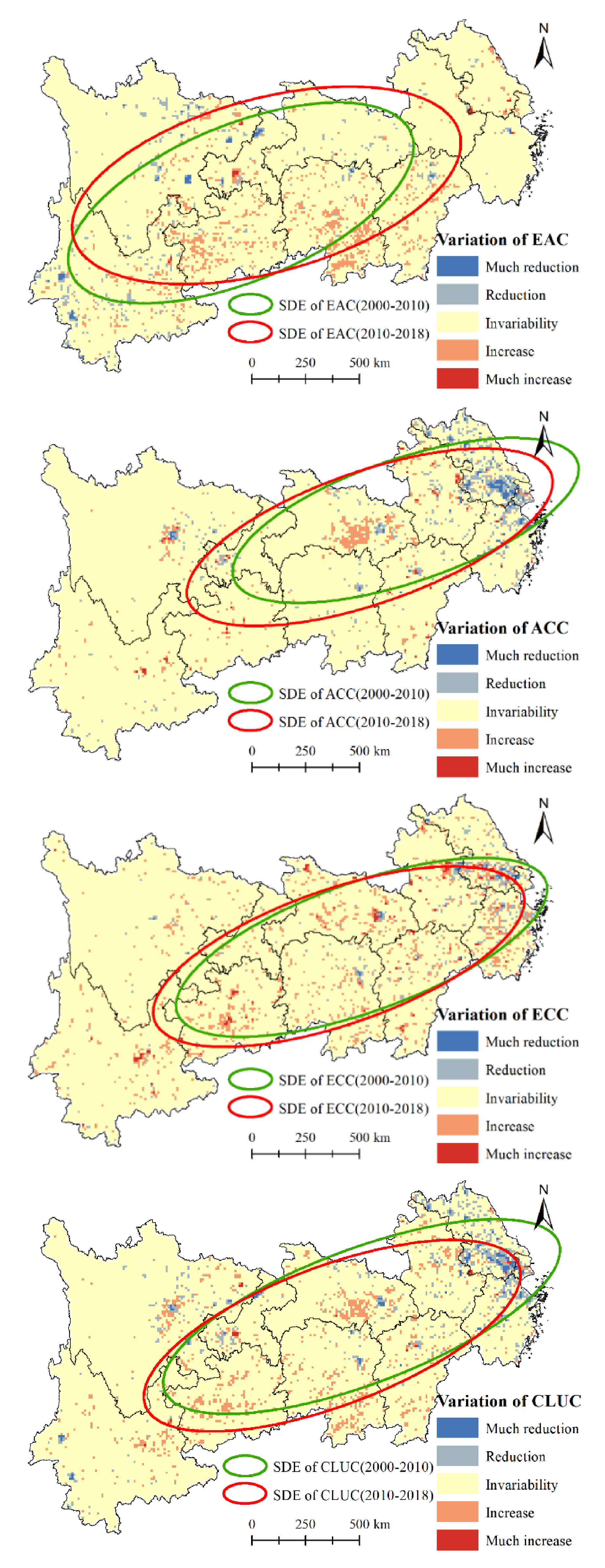
4.2.3. Spatiotemporal Variation Pattern and Standard Deviation Ellipse Analysis of Land Use Indicators
4.3. Driving Factors
5. Discussion
5.1. Major Influencing Factors of Land Use Conflict in YREB
5.2. Policy Implications
6. Conclusions
Author Contributions
Funding
Institutional Review Board Statement
Informed Consent Statement
Data Availability Statement
Acknowledgments
Conflicts of Interest
References
- Crutzen, P.J. Geology of mankind. Nature 2002, 415, 23. [Google Scholar] [CrossRef] [Scilit]
- Thomson, G.; Newman, P. Cities and the Anthropocene: Urban governance for the new era of regenerative cities. Urban Stud. 2020, 57, 1502–1519. [Google Scholar] [CrossRef] [Scilit]
- Trischler, H. The Anthropocene: A Challenge for the History of Science, Technology, and the Environment. NTM 2016, 24, 309–335. [Google Scholar] [CrossRef] [Scilit] [PubMed]
- Grimm, N.B.; Faeth, S.H.; Golubiewski, N.E.; Redman, C.L.; Wu, J.; Bai, X.; Briggs, J.M. Global change and the ecology of cities. Science 2008, 319, 756–760. [Google Scholar] [CrossRef] [Scilit]
- Tu, Y.; Chen, B.; Yu, L.; Xin, Q.; Gong, P.; Xu, B. How does urban expansion interact with cropland loss? A comparison of 14 Chinese cities from 1980 to 2015. Landsc. Ecol. 2020. [Google Scholar] [CrossRef] [Scilit]
- Curtis, P.G.; Slay, C.M.; Harris, N.L.; Tyukavina, A.; Hansen, M.C. Classifying drivers of global forest loss. Science 2018, 361, 1108–1111. [Google Scholar] [CrossRef] [Scilit]
- Zhang, W.; Villarini, G.; Vecchi, G.A.; Smith, J.A. Urbanization exacerbated the rainfall and flooding caused by hurricane Harvey in Houston. Nature 2018, 563, 384–388. [Google Scholar] [CrossRef] [Scilit]
- Pielke, R.A. Land Use and Climate Change. Science 2005, 310, 1625. [Google Scholar] [CrossRef] [Scilit]
- Jianchu, X.; Fox, J.; Vogler, J.B.; Yongshou, Z.P.; Lixin, Y.; Jie, Q.; Leisz, S. Land-use and land-cover change and farmer vulnerability in Xishuangbanna prefecture in southwestern China. Environ. Manag. 2005, 36, 404–413. [Google Scholar] [CrossRef] [Scilit]
- McNeeley, S.M.; Even, T.L.; Gioia, J.B.M.; Knapp, C.N.; Beeton, T.A. Expanding vulnerability assessment for public lands: The social complement to ecological approaches. Clim. Risk Manag. 2017, 16, 106–119. [Google Scholar] [CrossRef] [Scilit]
- Lioubimtseva, E. A multi-scale assessment of human vulnerability to climate change in the Aral Sea basin. Environ. Earth Sci. 2014, 73, 719–729. [Google Scholar] [CrossRef] [Scilit]
- Huang, X.; Huang, X.; He, Y.; Yang, X. Assessment of livelihood vulnerability of land-lost farmers in urban fringes: A case study of Xi’an, China. Habitat Int. 2017, 59, 1–9. [Google Scholar] [CrossRef] [Scilit]
- Liu, Y.; Fang, F.; Li, Y. Key issues of land use in China and implications for policy making. Land Use Policy 2014, 40, 6–12. [Google Scholar] [CrossRef] [Scilit]
- Qu, Y.; Long, H. The economic and environmental effects of land use transitions under rapid urbanization and the implications for land use management. Habitat Int. 2018, 82, 113–121. [Google Scholar] [CrossRef] [Scilit]
- Liang, X.; Jin, X.; Ren, J.; Gu, Z.; Zhou, Y. A research framework of land use transition in Suzhou City coupled with land use structure and landscape multifunctionality. Sci. Total Environ. 2020, 737, 139932. [Google Scholar] [CrossRef] [Scilit]
- Long, H.; Qu, Y. Land use transitions and land management: A mutual feedback perspective. Land Use Policy 2018, 74, 111–120. [Google Scholar] [CrossRef] [Scilit]
- Wang, J.; Li, Y.; Wang, Q.; Cheong, K.C. Urban–Rural Construction Land Replacement for More Sustainable Land Use and Regional Development in China: Policies and Practices. Land 2019, 8, 171. [Google Scholar] [CrossRef] [Scilit]
- Huang, L.; Hu, S.; Li, S.; Fu, Z. Nonmarketization Bargaining and Actual Compensation Level for Land Requisition: A Qualitative Comparative Analysis of China’s Land Requisition Conflict Events. Sustainability 2019, 11, 6084. [Google Scholar] [CrossRef] [Scilit]
- Ma, W.; Jiang, G.; Chen, Y.; Qu, Y.; Zhou, T.; Li, W. How feasible is regional integration for reconciling land use conflicts across the urban–rural interface? Evidence from Beijing–Tianjin–Hebei metropolitan region in China. Land Use Policy 2020, 92, 104433. [Google Scholar] [CrossRef] [Scilit]
- Wu, Y.; Heerink, N. Foreign direct investment, fiscal decentralization and land conflicts in China. China Econ. Rev. 2016, 38, 92–107. [Google Scholar] [CrossRef] [Scilit]
- Zhou, D.; Lin, Z.; Lim, S.H. Spatial characteristics and risk factor identification for land use spatial conflicts in a rapid urbanization region in China. Environ. Monit. Assess. 2019, 191, 677. [Google Scholar] [CrossRef] [Scilit] [PubMed]
- Liu, Z.; Liu, Y.; Baig, M.H.A. Biophysical effect of conversion from croplands to grasslands in water-limited temperate regions of China. Sci. Total Environ. 2019, 648, 315–324. [Google Scholar] [CrossRef] [Scilit] [PubMed]
- Bergius, M.; Benjaminsen, T.A.; Maganga, F.; Buhaug, H. Green economy, degradation narratives, and land-use conflicts in Tanzania. World Dev. 2020, 129, 104850. [Google Scholar] [CrossRef] [Scilit]
- Pacheco, F.A.L.; Varandas, S.G.P.; Sanches Fernandes, L.F.; Valle Junior, R.F. Soil losses in rural watersheds with environmental land use conflicts. Sci. Total Environ. 2014, 485–486, 110–120. [Google Scholar] [CrossRef] [Scilit]
- Valle Junior, R.F.; Varandas, S.G.; Sanches Fernandes, L.F.; Pacheco, F.A. Groundwater quality in rural watersheds with environmental land use conflicts. Sci. Total Environ. 2014, 493, 812–827. [Google Scholar] [CrossRef] [Scilit]
- Moore, S.A.; Brown, G.; Kobryn, H.; Strickland-Munro, J. Identifying conflict potential in a coastal and marine environment using participatory mapping. J. Environ. Manag. 2017, 197, 706–718. [Google Scholar] [CrossRef] [Scilit]
- Kim, I.; Arnhold, S. Mapping environmental land use conflict potentials and ecosystem services in agricultural watersheds. Sci. Total Environ. 2018, 630, 827–838. [Google Scholar] [CrossRef] [Scilit]
- Helwege, A. Challenges with resolving mining conflicts in Latin America. Extr. Ind. Soc. 2015, 2, 73–84. [Google Scholar] [CrossRef] [Scilit]
- Helbron, H.; Schmidt, M.; Glasson, J.; Downes, N. Indicators for strategic environmental assessment in regional land use planning to assess conflicts with adaptation to global climate change. Ecol. Indic. 2011, 11, 90–95. [Google Scholar] [CrossRef] [Scilit]
- Chen, S.; Yi, Z.-F.; Campos-Arceiz, A.; Chen, M.-Y.; Webb, E.L. Developing a spatially-explicit, sustainable and risk-based insurance scheme to mitigate human–wildlife conflict. Biol. Conserv. 2013, 168, 31–39. [Google Scholar] [CrossRef] [Scilit]
- He, Y.; Tang, C.; Zhou, G.; He, S. The Analysis of Spatial Conflict Measurement in Fast Urbanization Region from the Perspective of Geography——A Case Study of Changsha-Zhuzhou-Xiangtan Urban Agglomeration. J. Nat. Resour. 2014, 29, 1660–1674. [Google Scholar]
- Zou, L.; Liu, Y.; Wang, J.; Yang, Y.; Wang, Y. Land use conflict identification and sustainable development scenario simulation on China’s southeast coast. J. Clean. Prod. 2019, 238, 117899. [Google Scholar] [CrossRef] [Scilit]
- Iojă, C.I.; Niţă, M.R.; Vânău, G.O.; Onose, D.A.; Gavrilidis, A.A. Using multi-criteria analysis for the identification of spatial land-use conflicts in the Bucharest Metropolitan Area. Ecol. Indic. 2014, 42, 112–121. [Google Scholar] [CrossRef] [Scilit]
- You, H.; Yang, X. Urban expansion in 30 megacities of China: Categorizing the driving force profiles to inform the urbanization policy. Land Use Policy 2017, 68, 531–551. [Google Scholar] [CrossRef] [Scilit]
- Long, H.; Qu, Y.; Tu, S.; Zhang, Y.; Jiang, Y. Development of land use transitions research in China. J. Geogr. Sci. 2020, 30, 1195–1214. [Google Scholar] [CrossRef] [Scilit]
- Xu, Y.; McNamara, P.; Wu, Y.; Dong, Y. An econometric analysis of changes in arable land utilization using multinomial logit model in Pinggu district, Beijing, China. J. Environ. Manag. 2013, 128, 324–334. [Google Scholar] [CrossRef] [Scilit] [PubMed]
- Feng, Y.; Liu, Y.; Tong, X. Spatiotemporal variation of landscape patterns and their spatial determinants in Shanghai, China. Ecol. Indic. 2018, 87, 22–32. [Google Scholar] [CrossRef] [Scilit]
- Liu, Y.; Peng, J.; Zhang, T.; Zhao, M. Assessing landscape eco-risk associated with hilly construction land exploitation in the southwest of China: Trade-off and adaptation. Ecol. Indic. 2016, 62, 289–297. [Google Scholar] [CrossRef] [Scilit]
- Li, Y.; Sun, X.; Zhu, X.; Cao, H. An early warning method of landscape ecological security in rapid urbanizing coastal areas and its application in Xiamen, China. Ecol. Model. 2010, 221, 2251–2260. [Google Scholar] [CrossRef] [Scilit]
- Wang, D.; Jiang, D.; Fu, J.; Lin, G.; Zhang, J. Comprehensive Assessment of Production–Living–Ecological Space Based on the Coupling Coordination Degree Model. Sustainability 2020, 12, 2009. [Google Scholar] [CrossRef] [Scilit]
- Lin, G.; Jiang, D.; Fu, J.; Cao, C.; Zhang, D. Spatial Conflict of Production–Living–Ecological Space and Sustainable-Development Scenario Simulation in Yangtze River Delta Agglomerations. Sustainability 2020, 12, 2175. [Google Scholar] [CrossRef] [Scilit]
- Jin, G.; Deng, X.; Zhao, X.; Guo, B.; Yang, J. Spatiotemporal patterns in urbanization efficiency within the Yangtze River Economic Belt between 2005 and 2014. J. Geogr. Sci. 2018, 28, 1113–1126. [Google Scholar] [CrossRef] [Scilit]
- Ma, Q.; He, C.; Wu, J. Behind the rapid expansion of urban impervious surfaces in China: Major influencing factors revealed by a hierarchical multiscale analysis. Land Use Policy 2016, 59, 434–445. [Google Scholar] [CrossRef] [Scilit]
- Mantas, V.M.; Marques, J.C.; Pereira, A.J.S.C. A geospatial approach to monitoring impervious surfaces in watersheds using Landsat data (the Mondego Basin, Portugal as a case study). Ecol. Indic. 2016, 71, 449–466. [Google Scholar] [CrossRef] [Scilit]
- Tong, L.; Hu, S.; Frazier, A.E. Hierarchically measuring urban expansion in fast urbanizing regions using multi-dimensional metrics: A case of Wuhan metropolis, China. Habitat Int. 2019, 94, 102070. [Google Scholar] [CrossRef] [Scilit]
- Huang, X.; Xia, J.; Xiao, R.; He, T. Urban expansion patterns of 291 Chinese cities, 1990–2015. Int. J. Digit. Earth 2017, 12, 62–77. [Google Scholar] [CrossRef] [Scilit]
- Mitsova, D. Coupling Land Use Change Modeling with Climate Projections to Estimate Seasonal Variability in Runoff from an Urbanizing Catchment Near Cincinnati, Ohio. ISPRS Int. J. Geo-Inf. 2014, 3, 1256–1277. [Google Scholar] [CrossRef] [Scilit]
- Du, N.; Ottens, H.; Sliuzas, R. Spatial impact of urban expansion on surface water bodies—A case study of Wuhan, China. Landsc. Urban Plan. 2010, 94, 175–185. [Google Scholar] [CrossRef] [Scilit]
- Yao, X.; Christensen, M.J.; Bao, G.; Zhang, C.; Li, X.; Li, C.; Nan, Z. A toxic endophyte-infected grass helps reverse degradation and loss of biodiversity of over-grazed grasslands in northwest China. Sci. Rep. 2015, 5, 18527. [Google Scholar] [CrossRef] [Scilit]
- Montanari, A.; Londei, A.; Staniscia, B. Can we interpret the evolution of coastal land use conflicts? Using Artificial Neural Networks to model the effects of alternative development policies. Ocean Coast. Manag. 2014, 101, 114–122. [Google Scholar] [CrossRef] [Scilit]
- Valle Junior, R.F.; Varandas, S.G.P.; Sanches Fernandes, L.F.; Pacheco, F.A.L. Environmental land use conflicts: A threat to soil conservation. Land Use Policy 2014, 41, 172–185. [Google Scholar] [CrossRef] [Scilit]
- Liu, J.; Kuang, W.; Zhang, Z.; Xu, X.; Qin, Y.; Ning, J.; Zhou, W.; Zhang, S.; Li, R.; Yan, C.; et al. Spatiotemporal characteristics, patterns, and causes of land-use changes in China since the late 1980s. J. Geogr. Sci. 2014, 24, 195–210. [Google Scholar] [CrossRef] [Scilit]
- Liu, J.; Liu, M.; Tian, H.; Zhuang, D.; Zhang, Z.; Zhang, W.; Tang, X.; Deng, X. Spatial and temporal patterns of China’s cropland during 1990–2000: An analysis based on Landsat TM data. Remote Sens. Environ. 2005, 98, 442–456. [Google Scholar] [CrossRef] [Scilit]
- Li, D.; Xu, E.; Zhang, H. Influence of ecological land change on wind erosion prevention service in arid area of northwest China from 1990 to 2015. Ecol. Indic. 2020, 117, 106686. [Google Scholar] [CrossRef] [Scilit]
- Ning, J.; Liu, J.; Zhao, G. Spatio-temporal characteristics of disturbance of land use change on major ecosystem function zones in China. Chin. Geogr. Sci. 2015, 25, 523–536. [Google Scholar] [CrossRef] [Scilit]
- Zhong, Y.; Lin, A.; He, L.; Zhou, Z.; Yuan, M. Spatiotemporal Dynamics and Driving Forces of Urban Land-Use Expansion: A Case Study of the Yangtze River Economic Belt, China. Remote Sens. 2020, 12, 287. [Google Scholar] [CrossRef] [Scilit]
- Wang, H.; Meng, X. Siol Map Based Harmonized World Soil Database (v1.2); National Tibetan Plateau Data Center, Institute of Tibetan Plateau Research: Beijing, China, 2018. [Google Scholar]
- Wieder, W. Regridded Harmonized World Soil Database v1.2; ORNL Distributed Active Archive Center: Oak Ridge, TN, USA, 2014. [Google Scholar]
- Fischer, G.; Nachtergaele, F.; Prieler, S.; van Velthuizen, H.T.; Verelst, L.; Wiberg, D. Global Agro-Ecological Zones Assessment for Agriculture (GAEZ 2008); IIASA: Laxenburg, Austria; FAO: Rome, Italy, 2008. [Google Scholar]
- Shen, Y.; Xiong, A. Validation and comparison of a new gauge-based precipitation analysis over mainland China. Int. J. Climatol. 2016, 36, 252–265. [Google Scholar] [CrossRef] [Scilit]
- Zhang, Y.; Long, H.; Tu, S.; Ge, D.; Ma, L.; Wang, L. Spatial identification of land use functions and their tradeoffs/synergies in China: Implications for sustainable land management. Ecol. Indic. 2019, 107, 105550. [Google Scholar] [CrossRef] [Scilit]
- Liao, G.; He, P.; Gao, X.; Deng, L.; Zhang, H.; Feng, N.; Zhou, W.; Deng, O. The Production–Living–Ecological Land Classification System and Its Characteristics in the Hilly Area of Sichuan Province, Southwest China Based on Identification of the Main Functions. Sustainability 2019, 11, 1600. [Google Scholar] [CrossRef] [Scilit]
- Zhao, X.; Li, S.; Pu, J.; Miao, P.; Wang, Q.; Tan, K. Optimization of the National Land Space Based on the Coordination of Urban-Agricultural-Ecological Functions in the Karst Areas of Southwest China. Sustainability 2019, 11, 6752. [Google Scholar] [CrossRef] [Scilit]
- Gao, L.; Ma, C.; Wang, Q.; Zhou, A. Sustainable use zoning of land resources considering ecological and geological problems in Pearl River Delta Economic Zone, China. Sci. Rep. 2019, 9, 16052. [Google Scholar] [CrossRef] [Scilit]
- Yin, C.; Kong, X.; Liu, Y.; Wang, J.; Wang, Z. Spatiotemporal changes in ecologically functional land in China: A quantity-quality coupled perspective. J. Clean. Prod. 2019, 238, 117917. [Google Scholar] [CrossRef] [Scilit]
- Long, H.; Liu, Y.; Hou, X.; Li, T.; Li, Y. Effects of land use transitions due to rapid urbanization on ecosystem services: Implications for urban planning in the new developing area of China. Habitat Int. 2014, 44, 536–544. [Google Scholar] [CrossRef] [Scilit]
- Chi, Y.; Shi, H.; Zheng, W.; Sun, J.; Fu, Z. Spatiotemporal characteristics and ecological effects of the human interference index of the Yellow River Delta in the last 30 years. Ecol. Indic. 2018, 89, 880–892. [Google Scholar] [CrossRef] [Scilit]
- Valera, C.A.; Valle Junior, R.F.; Varandas, S.G.P.; Sanches Fernandes, L.F.; Pacheco, F.A.L. The role of environmental land use conflicts in soil fertility: A study on the Uberaba River basin, Brazil. Sci. Total Environ. 2016, 562, 463–473. [Google Scholar] [CrossRef] [Scilit]
- Li, T.; Long, H.; Zhang, Y.; Tu, S.; Ge, D.; Li, Y.; Hu, B. Analysis of the spatial mismatch of grain production and farmland resources in China based on the potential crop rotation system. Land Use Policy 2017, 60, 26–36. [Google Scholar] [CrossRef] [Scilit]
- Ge, D.; Long, H.; Zhang, Y.; Ma, L.; Li, T. Farmland transition and its influences on grain production in China. Land Use Policy 2018, 70, 94–105. [Google Scholar] [CrossRef] [Scilit]
- Yang, J.; Yang, J.; Luo, X.; Huang, C. Impacts by expansion of human settlements on nature reserves in China. J. Environ. Manag. 2019, 248, 109233. [Google Scholar] [CrossRef] [Scilit] [PubMed]
- Nguyen, T.T.; Verdoodt, A.; Van, Y.T.; Delbecque, N.; Tran, T.C.; Van Ranst, E. Design of a GIS and multi-criteria based land evaluation procedure for sustainable land-use planning at the regional level. Agric. Ecosyst. Environ. 2015, 200, 1–11. [Google Scholar] [CrossRef] [Scilit]
- Li, J.; Jiang, H.; Bai, Y.; Alatalo, J.M.; Li, X.; Jiang, H.; Liu, G.; Xu, J. Indicators for spatial–temporal comparisons of ecosystem service status between regions: A case study of the Taihu River Basin, China. Ecol. Indic. 2016, 60, 1008–1016. [Google Scholar] [CrossRef] [Scilit]
- Deng, X.; Zhao, C.; Yan, H. Systematic Modeling of Impacts of Land Use and Land Cover Changes on Regional Climate: A Review. Adv. Meteorol. 2013, 2013, 1–11. [Google Scholar] [CrossRef] [Scilit]
- Kuang, W.; Liu, J.; Dong, J.; Chi, W.; Zhang, C. The rapid and massive urban and industrial land expansions in China between 1990 and 2010: A CLUD-based analysis of their trajectories, patterns, and drivers. Landsc. Urban Plan. 2016, 145, 21–33. [Google Scholar] [CrossRef] [Scilit]
- Viglia, S.; Civitillo, D.F.; Cacciapuoti, G.; Ulgiati, S. Indicators of environmental loading and sustainability of urban systems. An emergy-based environmental footprint. Ecol. Indic. 2018, 94, 82–99. [Google Scholar] [CrossRef] [Scilit]
- Jackson, C.R.; Bahn, R.A.; Webster, J.R. Water Quality Signals from Rural Land Use and Exurbanization in a Mountain Landscape: What’s Clear and What’s Confounded? JAWRA J. Am. Water Resour. Assoc. 2017, 53, 1212–1228. [Google Scholar] [CrossRef] [Scilit]
- Chen, K.; Wang, X.; Li, D.; Li, Z. Driving force of the morphological change of the urban lake ecosystem: A case study of Wuhan, 1990–2013. Ecol. Model. 2015, 318, 204–209. [Google Scholar] [CrossRef] [Scilit]
- Feng, Y.; Yang, Q.; Tong, X.; Chen, L. Evaluating land ecological security and examining its relationships with driving factors using GIS and generalized additive model. Sci. Total Environ. 2018, 633, 1469–1479. [Google Scholar] [CrossRef] [Scilit]
- Hu, X.; Wu, Z.; Wu, C.; Ye, L.; Lan, C.; Tang, K.; Xu, L.; Qiu, R. Effects of road network on diversiform forest cover changes in the highest coverage region in China: An analysis of sampling strategies. Sci. Total Environ. 2016, 565, 28–39. [Google Scholar] [CrossRef] [Scilit]
- Selva, N.; Kreft, S.; Kati, V.; Schluck, M.; Jonsson, B.-G.; Mihok, B.; Okarma, H.; Ibisch, P.L. Roadless and Low-Traffic Areas as Conservation Targets in Europe. Environ. Manag. 2011, 48, 865–877. [Google Scholar] [CrossRef] [Scilit]
- Mo, W.; Wang, Y.; Zhang, Y.; Zhuang, D. Impacts of road network expansion on landscape ecological risk in a megacity, China: A case study of Beijing. Sci. Total Environ. 2017, 574, 1000–1011. [Google Scholar] [CrossRef] [Scilit]
- Tan, M.; Li, X.; Xie, H.; Lu, C. Urban land expansion and arable land loss in China—a case study of Beijing–Tianjin–Hebei region. Land Use Policy 2005, 22, 187–196. [Google Scholar] [CrossRef] [Scilit]
- Liu, Y.; Long, H.; Li, T.; Tu, S. Land use transitions and their effects on water environment in Huang-Huai-Hai Plain, China. Land Use Policy 2015, 47, 293–301. [Google Scholar] [CrossRef] [Scilit]
- Wang, L.; Pan, Y.; Cao, Y.; Li, B.; Wang, Q.; Wang, B.; Pang, W.; Zhang, J.; Zhu, Z.; Deng, G. Detecting early signs of environmental degradation in protected areas: An example of Jiuzhaigou Nature Reserve, China. Ecol. Indic. 2018, 91, 287–298. [Google Scholar] [CrossRef] [Scilit]



| Data Name | Data Type | Time Period | Resolution | Data Source |
|---|---|---|---|---|
| Land use/land cover data | Grid | 2000, 2010, 2018 | 30 m × 30 m | Resource and Environment Science and Data Center |
| DMSP/OLS Night Light Data | Grid | 2000, 2010, 2018 | 30 arc-seconds | National Geophysical Data Center |
| NDVI | Grid | 2000, 2010, 2018 | 1000 m × 1000 m | Resource and Environment Science and Data Center |
| Meteorological data | Vector | 2000, 2010, 2018 | 0.25° × 0.25° | China Meteorological Administration |
| DEM | Grid | 2003 | 90 m × 90 m | United States Geological Survey (USGS) |
| Soil quality data | Grid | 2000 | 30 arc-seconds | Harmonized World Soil Database |
| National boundary, sea land border, and major rivers | Vector | 2019 | 1:60,000,000 | Standard Map Service System |
| Administrative boundary and road map | Vector | 2015 | 1:250,000 | National Catalogue Service for Geographic Information |
| Socioeconomic data | Txt | 2018 | County level | Statistical Yearbook of Chinese Cities |
| Classes | Land Use Type | Description |
|---|---|---|
| Ecological land | Forest, grasslands, rivers, lakes, shoals, reservoirs, ponds, glaciers, and unutilized land | These land use types provide numerous ecological functions, such as climate regulation, gas regulation, water regulation, soil retention, and biodiversity. |
| Construction land | Urban and rural residential lands; construction land, including industrial, mining, and storage lands and roads. | These land use types mainly composed of impervious surface can provide industrial and mineral production as well as living functions, such as residence, shopping, education, and medical treatment. |
| Agricultural land | Paddy fields, irrigated land, and arid land. | The primary function of these land use types is agricultural production. |
| Criteria | Aptitude, impact, and feasibility class a | |||
| S1 | S2 | S3 | N | |
| Length of dry season (months) | 0–2 | 2–3 | 3–4 | >4 |
| Mean annual temperature (°C) | >22 | 22–20 | 20–18 | <18 |
| Mean annual maximum temperature (°C) | >27 | 27–24 | 24–22 | <22 |
| Slope (%) | 0–8 | 8–16 | 16–30 | >30 |
| Drainage | Good | Moderate | Imperfect | Poor |
| Soil texture b | C, SC, SCL | SL | LS | S |
| Soil depth (cm) | >100 | 100–70 | 70–50 | <50 |
| Distance to the road (m) | <500 | 500–1000 | 1000–2000 | >2000 |
| Variables | Abbreviation | Definitions |
|---|---|---|
| Demographic factors | TPOP | Total population of prefectural city |
| POPD | Population density of prefectural city | |
| Economic factors | GDPPC | per capita GDP |
| IFA | Investment in fixed assets | |
| TRSCG | Total retail sales of consumer goods | |
| Life factors | HBN | Number of hospital beds |
| MPUN | Number of mobile phone users | |
| RD | Road density |
| Class | 2000 | 2010 | 2018 | |
|---|---|---|---|---|
| Ecological land | Area (million ha) | 136.15 | 136.19 | 135.84 |
| Rate (%) | 66.41% | 66.43% | 66.26% | |
| Agricultural land | Area (million ha) | 64.02 | 62.08 | 60.88 |
| Rate (%) | 31.23% | 30.28% | 29.70% | |
| Construction land | Area (million ha) | 4.84 | 6.73 | 8.28 |
| Rate (%) | 2.35% | 3.28% | 4.04% |
| Class | 2000–2010 | 2010–2018 | Sum | Average | |
|---|---|---|---|---|---|
| ecological land | Annual variation (thousand ha) | 3.77 | −43.84 | −313.02 | −17.39 |
| Rate(%) | 0.02% | 0.08% | 0.86% | 0.05% | |
| agricultural land | Annual variation (thousand ha) | −193.9 | −149.53 | −3135.24 | −174.18 |
| Rate(%) | −0.30% | −0.24% | −4.92% | −0.27% | |
| construction land | Annual variation (thousand ha) | 190.13 | 193.37 | 3448.26 | 191.57 |
| Rate(%) | 18.51% | 13.86% | 295.98% | 16.44% |
| Variables | EAC | ACC | ECC | CLUC |
|---|---|---|---|---|
| TPOP | 0.534 ** | 0.800 ** | 0.470 ** | 0.839 ** |
| POPD | −0.189 * | 0.573 ** | — | 0.217 * |
| GDPPC | — | 0.428 ** | 0.349 ** | 0.244 ** |
| IFA | 0.438 ** | 0.736 ** | 0.530 ** | 0.775 ** |
| TRSCG | 0.245 ** | 0.780 ** | 0.471 ** | 0.677 ** |
| HBN | 0.559 * | 0.729 ** | 0.505 ** | 0.824 ** |
| MPUN | 0.389 ** | 0.826 ** | 0.517 ** | 0.790 ** |
| RD | 0.807 ** | 0.376 ** | 0.419 ** | 0.743 ** |
| Variables | EAC | ACC | ECC | CLUC |
|---|---|---|---|---|
| Model 1 | Model 2 | Model 3 | Model 3 | |
| TPOP | 0.002 * | 0.002 ** | — | 0.005 ** |
| POPD | −35.81 * | — | — | −42.61 ** |
| GDPPC | 2.214 ** | — | 0.068 ** | 1.812 ** |
| IFA | — | 0.99 * | 1.43 ** | — |
| TRSCG | — | 0.347 ** | — | — |
| HBN | 0.16 * | — | — | — |
| MPUN | — | 0.001 ** | — | — |
| RD | 0.448 ** | — | −0.315 ** | 0.512 * |
| R-squared | 0.653 | 0.734 | 0.360 | 0.803 |
| Year | Policy/Decree | Main Contents |
|---|---|---|
| 1986 | Farmland protection system | Cherish and rationally use every inch of land; effectively protecting farmlands is the basic state policy that our country must adhere to for a long time |
| 1989 | Basic farmland | The state established the basic farmland protection system and provided special protection to basic farmlands. |
| 1994 | Nature reserve regulation | The state formulated regulations to strengthen the construction and management of nature reserves and protect the natural environment and resources. |
| 1997 | Farmland dynamic balance system | The state established the farmland dynamic balance system in which farmlands are supplemented with no fewer than the land occupied by construction. |
| 1999 | Grain for Green | The state formulated policies to bring forward large-scale efforts to return farmlands to forests and restore livestock pastures to natural grasslands. |
| 2012 | Ecological red line | Areas with special and important ecological functions all over the country were strictly delineated into the ecological red line policy for special protection. |
| 2019 | National park | The state established a system of protected natural areas dominated by national parks. |
Publisher’s Note: MDPI stays neutral with regard to jurisdictional claims in published maps and institutional affiliations. |
© 2021 by the authors. Licensee MDPI, Basel, Switzerland. This article is an open access article distributed under the terms and conditions of the Creative Commons Attribution (CC BY) license (http://creativecommons.org/licenses/by/4.0/).
Share and Cite
Cui, J.; Kong, X.; Chen, J.; Sun, J.; Zhu, Y. Spatially Explicit Evaluation and Driving Factor Identification of Land Use Conflict in Yangtze River Economic Belt. Land 2021, 10, 43. https://doi.org/10.3390/land10010043
Cui J, Kong X, Chen J, Sun J, Zhu Y. Spatially Explicit Evaluation and Driving Factor Identification of Land Use Conflict in Yangtze River Economic Belt. Land. 2021; 10(1):43. https://doi.org/10.3390/land10010043
Chicago/Turabian StyleCui, Jiaxing, Xuesong Kong, Jing Chen, Jianwei Sun, and Yuanyuan Zhu. 2021. "Spatially Explicit Evaluation and Driving Factor Identification of Land Use Conflict in Yangtze River Economic Belt" Land 10, no. 1: 43. https://doi.org/10.3390/land10010043
APA StyleCui, J., Kong, X., Chen, J., Sun, J., & Zhu, Y. (2021). Spatially Explicit Evaluation and Driving Factor Identification of Land Use Conflict in Yangtze River Economic Belt. Land, 10(1), 43. https://doi.org/10.3390/land10010043