1. Introduction
The effects of natural phenomena and/or anthropic processes on built heritage are generally the “one-way” topic of most of the studies aiming at improving the knowledge of the possible interactions existing among the cultural heritage site and the surrounding environment.
In Italy, a long-lasting tradition of geological materials used as building materials for road pavements and residential buildings exists and, usually, the lithological features of materials vary according to the local geology from where they proceed.
In the Campania region, volcanics (lava blocks) and pyroclastics (coherent yellow and grey tuffs) mostly proceeding from the peri-vesuvian area and from the environs of other regional volcanic centres (e.g., Phlegrean Fields) characterize most of the built heritage dating from the Roman age up to the last decades.
These materials, which are normally affected by both chemical and mechanical alterations (especially when they are directly exposed to exogenous dynamics for long periods of time), have some peculiar behaviours which imply the capability of emitting low-intensity ionizing radiations whose levels are a function of the abundance of radioisotopes in the source rock.
Ionizing radiations—even at low intensity—can produce stochastic biological effects on the living beings exposed to them. The amount and the severity of the chemical and biological effects on a specific human tissue or organ can be expressed as the effective dose, which is also a function of both the absorbed energy per mass unit and the ability of radiations to transfer energy to the crossed material.
Evaluating the built heritage as a source of risk for people overturns the conventional point of view, or rather expands the cause-and-effect relationship among disastrous events, cultural heritage, and its conservation.
As a matter of the fact, a new perspective in the study of the interaction among the surrounding environment and radiogenic building materials can be considered especially for those ionizing radiations which have a high penetration capability (e.g., gamma rays), considering the potential influence that built heritage can have on human beings.
Legislative Decrees N. 230/1995 [
1], N. 241/2000 [
2], and N. 151/2001 [
3] (with subsequent amendments) represent the Italian legislation regulating human exposure conditions to ionizing radiation implementing the EURATOM Directives. Specifically, in accordance with the International Commission on Radiological Protection (ICRP) [
4], the effective dose limits for human beings not (directly or indirectly) exposed to ionizing radiation for work reasons is set at 1 mSv/y in addition to the environmental contributions given by cosmic radiations (with an average value of 0.4 mSv/y) and natural terrestrial radiations (with an average value of 0.5 mSv/y). Thus, a measured value of 1.9 mSv/y can be considered as a reference threshold to assess the onset of a potentially hazardous situation for the exposed population.
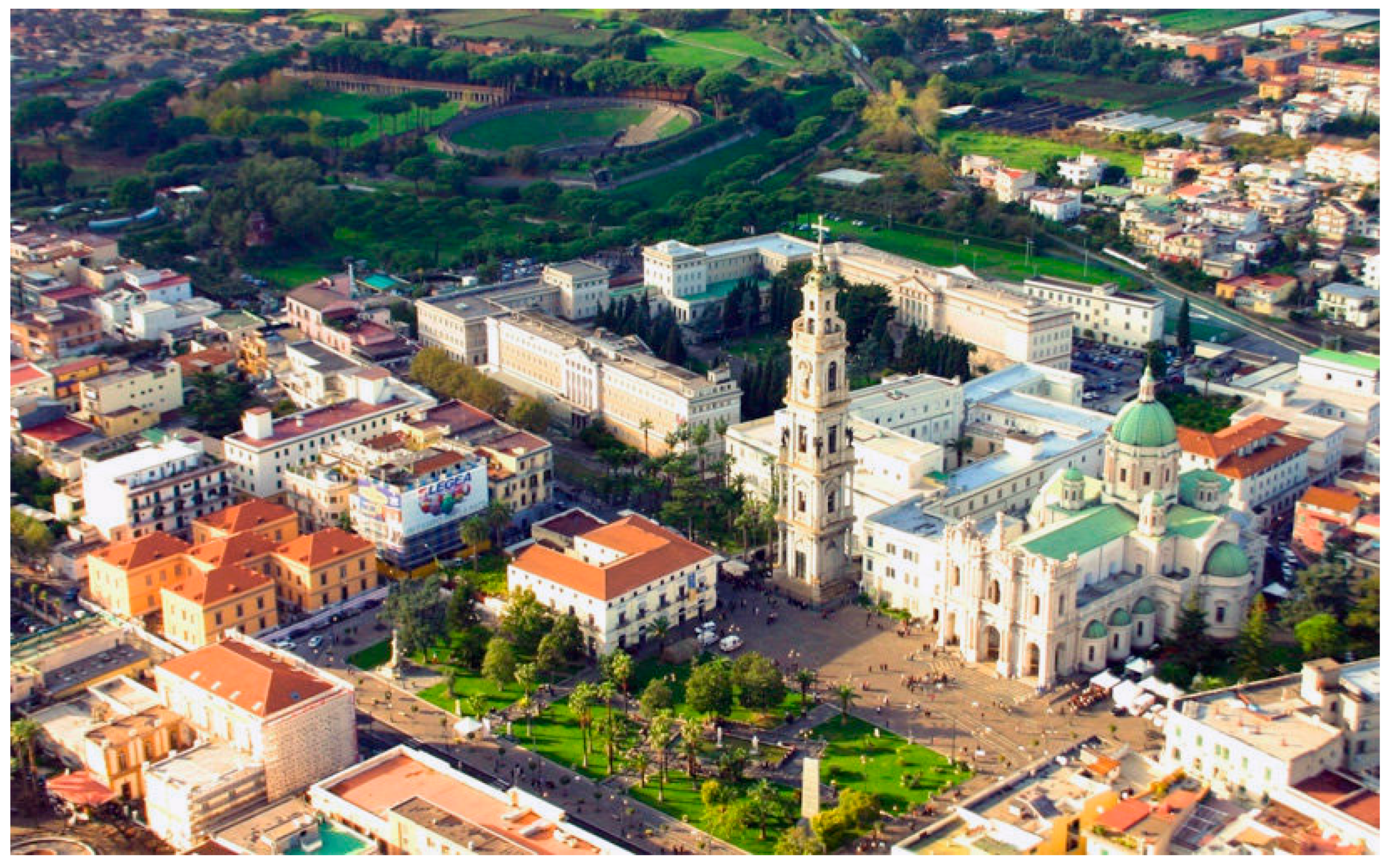
In light of the above considerations, due to both the huge presence of historical buildings and an intense touristic flow, the city of Pompei, on the southern side of the Somma-Vesuvius volcano, has been selected as a study area. Specifically, an assessment of the intensity and of the potential influence of gamma radiations emitted by built heritage on the local population and occasional visitors has been completed over a commonly crowded open space (Bartolo Longo Square,
Figure 1) surrounded by buildings mostly made of volcanic materials by using various constructive techniques in the last two centuries.
Given that ionizing radiation is therefore a further dimension of knowledge of the built heritage, in this paper, the Geographical Information System (GIS) and Building Information Modelling (BIM) are the experimentally adopted digital integrated tools to investigate the relationship among construction entities, building materials, and their effect on surroundings. Cadastral maps and open layers have been used to organise the GIS model for planning and classifying environmental radiation data, as well. Terrestrial laser scanning and mobile mapping data have been used to develop the BIM as semantic-aware three-dimensional modelling, capable of matching geometrical data to non-geometrical ones.
In addition, the possibility of using the emission spectra of materials as a fingerprint of their nature even when they are shielded by plasters or other isolating layers could be a non-invasive method to be explored and possibly to be developed.
To the best of our knowledge, this study represents the first instance of the implementation of radiometric prospecting on building heritage; additionally, the analysis of buildings’ radiation data through BIM and its thematic representations have no analogous case study.
2. Results
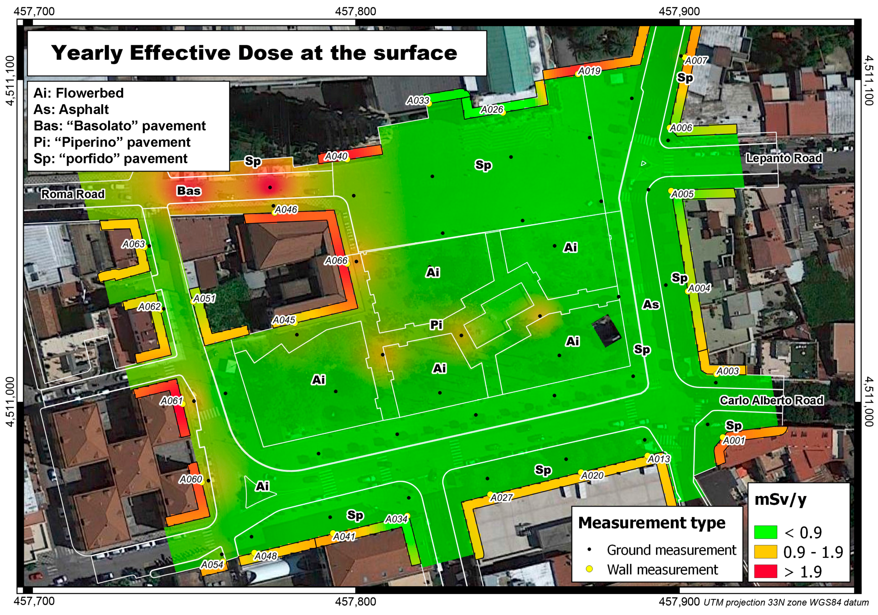
Figure 2 shows the distribution of the effective dose proceeding from pavement and building materials across the whole study area. Four types of flooring material have been recognised in the Square:
basolato, made by leucititic volcanic blocks, possibly proceeding from some local or Sicilian quarries;
piperino, made by trachitic/tefritic volcanic blocks, possibly proceeding from some Lazio quarries;
porfido, made by acidic effusive volcanic blocks, possibly proceeding from some Trentino quarries;
asphalt.
Apart of these materials, flowerbeds cover the 23% of the whole study area (ca. 16,500 sqm).
In terms of effective dose, the Square pavement is characterised by values ranging from 0.86 to 2.73 mSv/y.
Table 1 reports the basic statistical values featuring each material, showing how the
basolato flooring is the most emissive material, followed by
piperino,
porfido, and flowerbeds. Specifically, the
basolato flooring—on the north-western sector of the Square—surpasses the effective dose value of 1.9 mSv/y, considered as an attention threshold for public exposure to external ionising radiation.
Among the other materials, piperino—covering the walkways within the central garden—shows values between 0.9 and 1.9 mSv/y, below the attention threshold, but generally higher than porfido—used for sideways—and flowerbeds.
Asphalt—whose emission rate has been measured at only one station—is featured by a value of 1.71 mSv/y, which is almost unexpected, considering that it should not contain any volcanic/radiogenic material.
Measurements made on the surfaces of buildings surrounding B. Longo Square show a noticeable variability of the effective dose proceeding from the different fair-faced or plastered materials.
Specifically, higher values (>1.9 mSv/y) have been acquired in correspondence with:
the plastered surface of the building on the south-western corner of the study area, known as “Casa degli Operai”;
the plastered surface of the isolated building on north-western sector of the Square;
the fair-faced volcanic block surfaces of the fence wall on the sides of the Cathedral.
Intermediate values between 0.9 and 1.9 mSv/y have been recorded in correspondence with:
the plastered surface of two buildings on the south side of the Square, the Town Hall known as “Palazzo De Fusco”, in the western corner, and “Casa del Pellegrino”, in the eastern corner;
the plastered façade of the opposing buildings at the opening of Lepanto Road;
the plastered surfaces of two residential buildings on the east sector at the intersection with Roma Road;
the plastered south surface of the isolated building in the Square.
Lower values below 0.9 mSv/y have been acquired in correspondence with:
3. Discussion
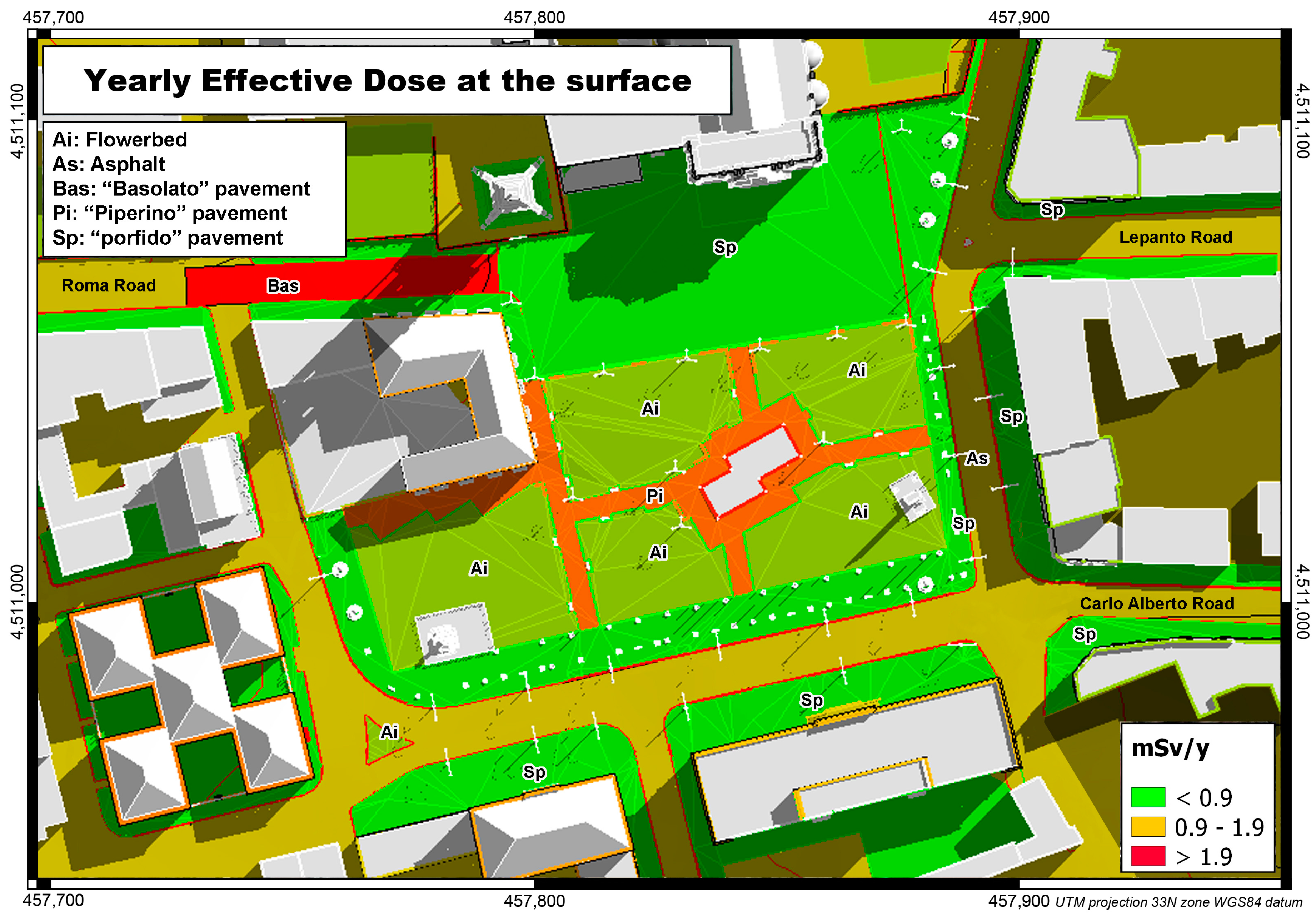
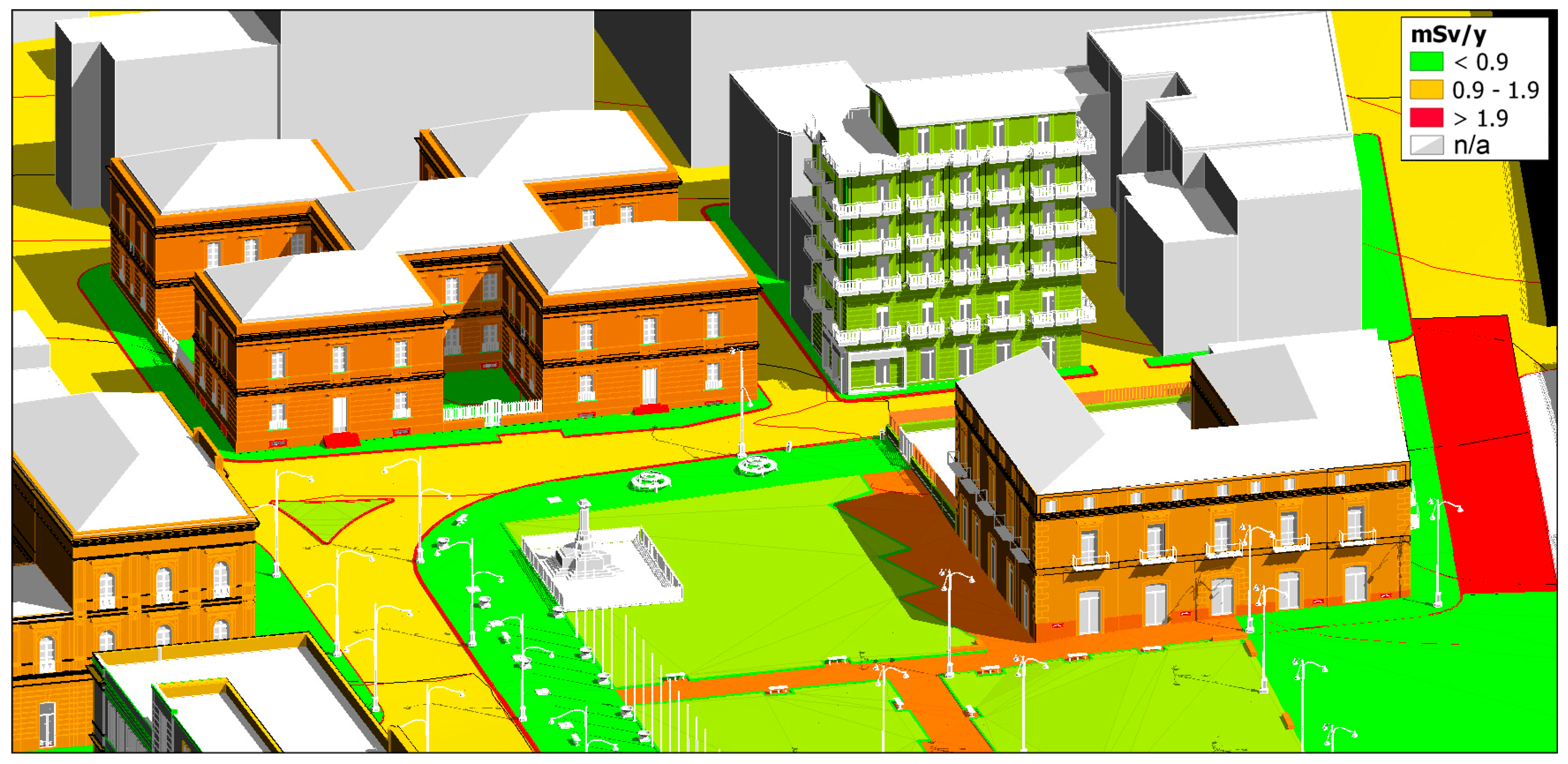
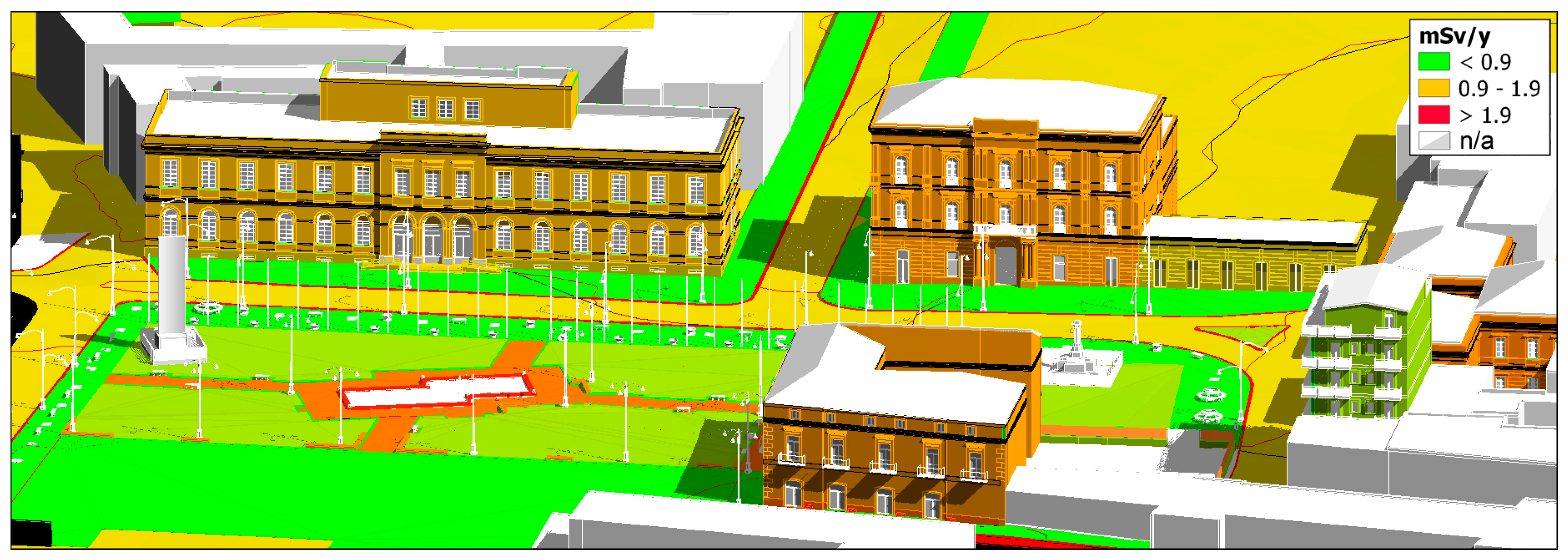
Thanks to BIM, a comprehensive representation of the effective dose distribution from construction entities has been generated by using a false colour palette; specifically, after calculating an average value of the effective dose for the different building materials, a model of the buildings has been generated and their external surfaces have been coloured according to the average effective dose produced by the main material constituting the construction entities (
Figure 3 and
Figure 4).
The colour ramp of the false colour palette—applied to the information models by means of the BimOne Color Splasher plug-in—range from green to red (associated to the highest emissive materials); as a matter of the fact, the construction entities made of higher emissive fair-faced materials, such as piperino, are reported in red such as the Roma Road segment, the sidewalk curbs, and the steps at main entrance of the “Casa degli Operai”.
The false colour representation—like thermal imaging—could reveal some invisible characteristics, as well.
Starting from the known effective dose generated from fair-faced materials, the effective dose associated with the plastered façades of the “Casa degli Operai”, the Town Hall, and the isolated building in the Square, coloured in ochre, suggests that beyond the plaster, a material comparable to the one making up the walkways at the central garden can be expected.
To confirm this, the historical documentation of the built heritage in Pompei—recorded as thematic datasets into the City Information Modelling (CIM)—allowed us to ascertain that
- (a)
the Town Hall and the isolated building—both dating to the middle of the 19th century—are tuff masonry buildings;
- (b)
the “Casa degli Operai”, built in 1887 [
6], and the “Casa del Pellegrino”—built in 1938 [
7]—are tuff masonry and concrete frame buildings.
- (c)
the rest of residential buildings—dating to the early of 20th century—are made by concrete frame structure and clay-brick dividing walls.
In general, in accordance with the effective dose average values set for the flooring materials, we can assume that all the higher values recorded on the fair-faced or plastered built surfaces can be associated with the presence of geologic material of igneous origin, while lower values are mostly related with sedimentary rocks, even if metamorphosed (e.g., marble).
It is interesting to observe that even when covered by plaster, igneous materials produce a noticeable effective dose which is still higher than other non-magmatic rocks, and this characteristic can become a useful tool to indirectly discriminate among the nature of building material even if they are shielded.
4. Materials and Methods
According to our research approach, the urban and built heritage documentation has been improved by the knowledge of the material features.
Thus, ionizing radiation is another non-geometrical information to be added to the already existing data asset which is widely used by Architectural and Urban Surveying. As matter of fact, the architectural surveying and modelling procedures and the environmental radiometric prospecting have been integrated into a technical-scientific protocol, with the aim of characterising road pavements, façades, urban furnishings, and building components.
All datasets about heritage documentation have been managed in multi-scalar GIS and BIM environments. Their interoperability has been made possible by matching both software databases through a common feature key; that is, the “construction entity by function”, detailed below. Those software databases have been continuously implemented during planning, acquisition, processing, and measurement steps.
In Bartolo Longo Square [
8,
9], the planning and acquisition steps have been concerned with the measurement of ionising radiation proceeding from building materials, referring to the geometrical data already acquired by authors in previous urban surveys [
10].
The cartographic model of Pompei has been organised in QGIS 2.18 software. Land cover (2014 Corine project), Building outline, Road path, and Road feature are the main vector layers; Google Maps (open layer) is the raster layer for a visible comparison.
Radiation measurements have been planned and drawn in a GIS model, according to orthogonal grids, oriented to Longo Square façades, with a nominal density of 330 sqm.
The grid nodes—defined by an ID code and geographic coordinates—have been transferred (KMZ files) to a handheld device into the “Maps.me” application (the free geo-location software by My.com) used to reach the stations (nodes) on which we acquired the gamma radiation.
The radiometric prospecting was achieved by means of a handheld spectrometer (AT6102, ATOMEX). The instrument is equipped with both a high-sensitivity scintillation NaI(Tl) detector and a Geiger–Muller counter.
The NaI(Tl) detector measuring range is 0.01–300 µSv/h with a ±20% maximum intrinsic relative error of measurement (with a measurement range of 50–3000 keV), and it is used for gamma-radiation detection and source localization, for radionuclide identification, and for gamma emission energy and radiation dose rate measuring.
The Geiger–Muller counter expands the gamma radiation dose rate measuring range of the NaI(Tl) detector up to100 mSv/h with a ±20% maximum intrinsic relative error of measurement (with a measurement range of 60–3000 keV).
At each station point, ionizing radiations were measured at two different heights (1 m and 0.2 m above ground level).
During the survey, the following alphanumeric information was recorded at each station: geo-coordinates of the site; date and time of acquisition; toponomastics and address; surface material in the direction of measure; spatial orientation of the measurement (N, E, W, S, Ground, Contact).
At the end of the instrumental acquisitions in B. Longo Square, 303 measurements had been recorded, including 73 measures in direct contact with the surface of the buildings.
After the raw data backup, the alphanumeric information registered on the handheld device was transferred to the QGIS model, according to the data interchange standards.
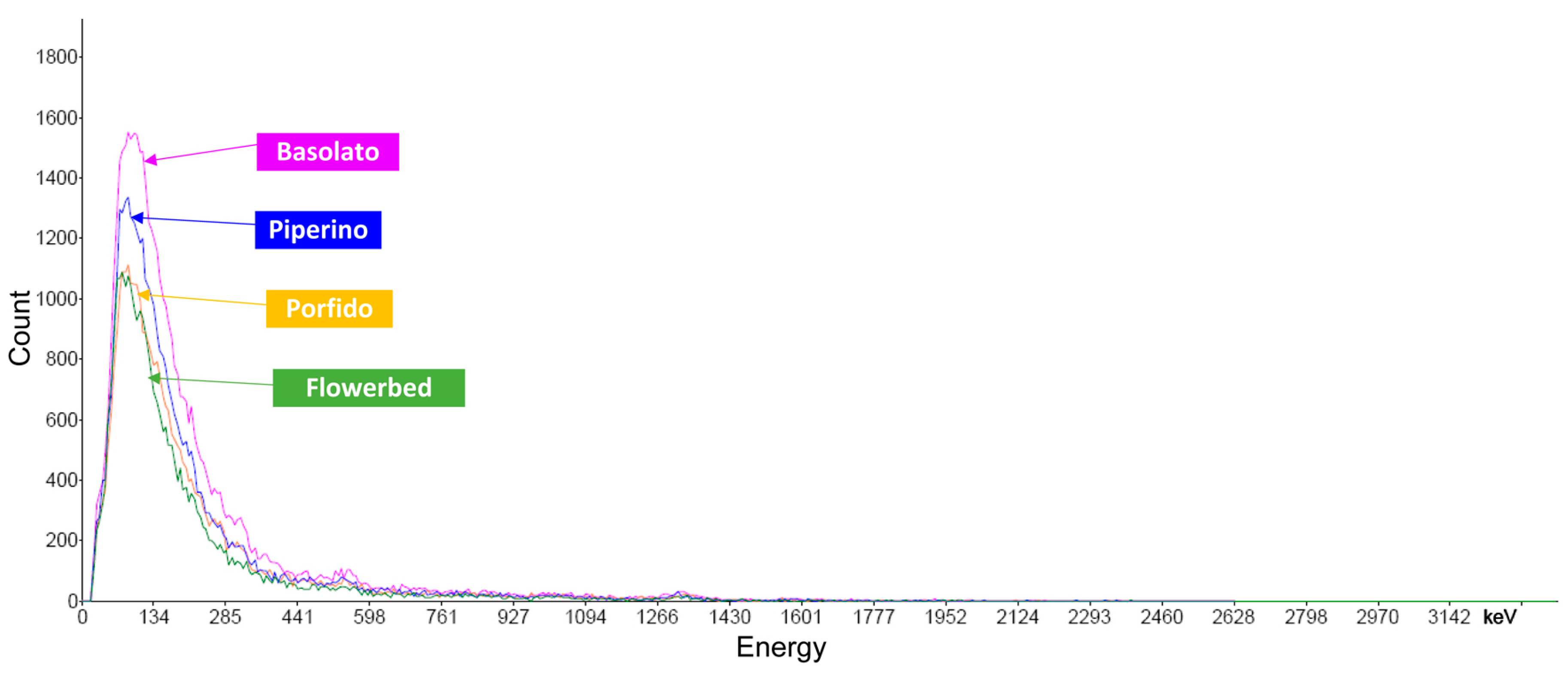
Radiometric measurements were processed in the Atas Lite software and, by using the emission spectra acquired (
Figure 5), the effective dose was calculated for each measuring point; after that, data were transferred to a GIS model matching common geographic coordinates. According to this approach, the non-spatial data (e.g., radiometry) become spatial, and for this reason they could be managed in the GIS model.
The approach to the CIM of B. Longo Square and to BIMs of the Square buildings is semantic, according to construction entities by function. The Information Models were organised in Autodesk Revit 2017 software (Educational licence). The construction entities in B. Longo Square are both industrial and traditional. The industrial entities (road attributes, urban furnishings, and some entities of contemporary buildings) were managed thanks to “IFC libraries”, while the traditional built entities were modelled according to the “as-built” methodology. In the latter case, the Elements, the Families, and the Types of BIMs were modelled starting from point cloud data. The geometrical 3D model approach was based on the selective segmentation by orthogonal cross-sections of point clouds and the morphological best fitting between point and surface data [
11,
12]. The hierarchical structure of Elements, Families, and Types were organised according to the OmniClass encoding, extended by industrial entities to “as-built” ones, making appropriate adaptations. The Ontology Web Language (open source Protégé software) was used to structure the BIM semantic hierarchy [
13].
The information modelling of B. Longo Square and its buildings was done integrating “IFC” and “as-built” approaches. The key modelling is the “construction entity by function” (OmniClass 11-00). The interoperability of georeferenced GIS, CIM, and BIMs was solved through this key.
A generic “construction entity by function” can be made by several materials, to which specific radiometric contact measurements correspond, opening to several analyses as discussed through the thematic pictures above.
Figure 2 and
Figure 6 show the interoperability among the Information Models; the GIS map (
Figure 2) represents the interpolated spatial distribution of the Yearly Effective Dose (YED), while the CIM map (
Figure 6) represents the YED proceeding from each flooring material, categorized as “construction entity by function”.
This logical structure is applicable to the classification of other non-spatial data among GIS, CIM, and BIM that could be useful to the built heritage documentation, towards a conscious conservation.
5. Conclusions
According to the semantic-aware Heritage Building Information Modeling (H-BIM) spread in the documentation of cultural heritage, the ionising radiations should be added to non-geometric data assets towards a better sustainable conservation process. Additionally, gamma-radiation detection could be used as a non-invasive technique to investigate the plastered building materials, as well as thermal and GPR scanning.
The cause-and-effect relationship among igneous building materials, their ionising radiation, and human health opens new critical assessments of the conservation concept.


