
A Mark along the Way: Schematic Rock Art and Communication Routes

Instituto de Estudios Prehistóricos, Grupo Quaternário e Pré-História do Centro de Geociências (u. ID73—FCT), C/John Lenon, n° 5, 06800 Mérida, Badajoz, Spain
Arts 2016, 5(3), 6; https://doi.org/10.3390/arts5030006
Submission received: 7 April 2016
/
Revised: 21 June 2016
/
Accepted: 25 June 2016
/
Published: 1 August 2016
Abstract
:On the Iberian Peninsula, during the Neolithic age, there was a new cycle of post-Palaeolithic rock art: schematic rock art. This rock art style is said to date from the 6th millennium BCE until the end of the Bronze Age (around the transition between the 2nd and 1st millennium BCE). Schematic rock art has been interpreted from different approaches (religious, semiological, social) according to the different lines of research followed in Spain for more than 100 years. In this article, based on the studies linked to “landscape archeology”, we are proposing an interpretative approach of schematic rock art. For us, this rock art style would have a functional character, landscape marker, reflecting close connections between the places chosen as a support for schematic depictions and ones with survival resources or communication routes between territories.
1. There Is Something That Doesn’t Work Here…
Schematic rock art research in the Iberian Peninsula has a long tradition, starting in the first decades of the last century. Important institutional figures, Spanish and foreign, have been involved in this research, most relevantly Eduardo Hernández Pacheco, Henri Breuil, and Juan Cabré. During this more than 100 years of research, different rock art documentation methods have been implemented while interpretative trends in schematic rock art were explored along different stages of the investigation. All have been discussed in previous works ([1] 23–37; [2,3,4]).
Over a long time, the “clues” or the instructions from excellent researchers were taken by us as authentic dogmas to localize the sheltered places with painted rock art ([5]: 513):
- -
- Smooth walls with reddish and yellowish tones, occupied by living lichens in contrast with the greyish tone of the rocks
- -
- Overhang crags, almost individualized, in the mountain range
- -
- Smooth walls where the reddish tones stand out
- -
- Big shelters that are easily seen from a distance
With these indications, locating shelters or other type of places with rock art seemed to be easy. However, we experienced many disappointments when arriving at wonderful sheltered places, authentic archetypes of sites that should contain rock art according to those definitions, and where we did not find any trace of rock paintings or engravings.
While the years passed and our research progressed, many places with schematic rock art were found. They were small-dimensioned shelters, cavities or projections on the rock with slight protected cornices, which had nothing or almost nothing to do with the ideal place defined by those researchers.
It was clear that the reason why those places were selected for rock art was different from simply choosing a quite outstanding place. The shelters were sometimes grouped in zones, with the paintings situated in protected places. However, in the same mountain range, there were also big shelters that had no graphic content.
On other occasions, the rock art sites of varied typologies, with a different number of panels, showing important diversity of figures appear along the mountain range, although without evident location criteria that help us to understand the reason for this selection. Finally, rock art shelters also appear isolated or in groups of maximal two shelters on prominent hills.
A full view of the results provided by our prospecting work makes it more evident that we faced different situations which, according to our hypothesis, corresponded to just a single motivation: to control the resources in the territory through the symbolization, either exerting the control in their communication routes or strategic enclaves associated with them (mountain passes, hills, fords, etc.), making depictions in places related to basic resources for the group subsistence (water, hunting, places for harvest), or indicating those elements related with the economic development (mainly outcrops or concentrations of minerals) existing in the area.
2. Establishing an Analysis Strategy
Extremadura is a region situated in Southwestern Spain, next to the Portuguese frontier. We have been focusing an important part of our research about schematic rock art in this region for more than twenty years. This has allowed us to locate more than five hundred places with prehistoric schematic paintings or engravings all over the territory [6,7]. Together with the group of shelters documented in Andalusia region, it is one of the most important concentrations of post-Paleolithic rock art in the Iberian Peninsula.
Further study of these enclaves, especially those where an important figurative diachronic sequence has been located, has allowed us to establish a chronological classification for schematic rock art, which is organized in three stages [8], whose basic characteristics are:
1st stage: ancient schematic rock art—identified with the first signs of this style, mainly symbols (dots, lines, sun figures, etc.), which appear during the earliest Neolithic period.
2nd stage: medium schematic rock art. It keeps the preceding iconographic basis and added a new figurative repertoire, which significantly modifies the percentage of depictions, giving outstanding prominence to human and animal figures, in contrast to the symbolism in the former stage. An important thematic complexity is also perceived in the scenography of the panels, as well as a new territorial distribution of the shelters. This distribution gives priority to the rock art shelter locations related with the strategic places for the control of the territory and the communication routes.
3rd stage: recent schematic rock art. It maintains thematic, scenographic and typology criteria of the middle stage, as also the tendency for location in places with an important strategic value. The elements with an ethnographic character clearly related to the Bronze Age (weapons, horned helmets, chariots, etc.) are the only ones that allow us to ascribe certain motifs to this last stage
Once these stages were established, it was necessary to analyze how the rock art of each stage interacted with the places where it had been represented. Therefore, this led us to establish a new classification as the first step of the analysis. This classification was strictly based on morphological criteria of the places where schematic rock art was discovered. In this way, five basic formats of rock art shelters were established:
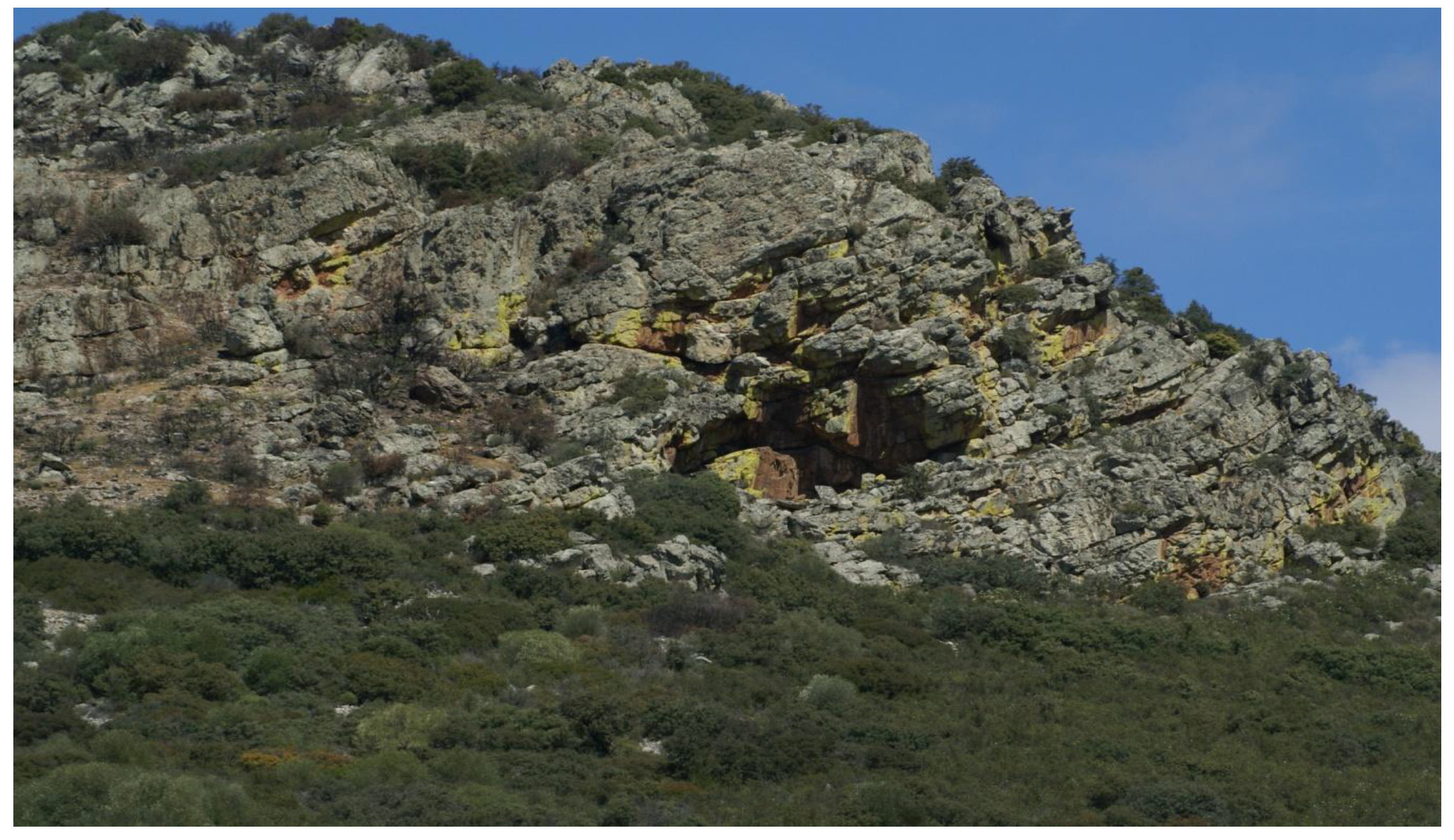
- Big shelters, above 10 m length, height and depth. They are easily perceptible in the landscape and their access does not usually present much difficulty (Figure 1).
- Shelters with certain spaciousness and a variable depth, although not exceeding 10 m. They can be easily used as shelter for one or more people (Figure 2).
- Smooth walls leaning slightly. Only this slight inclination allows preservation of motifs in inclement weather (Figure 3).
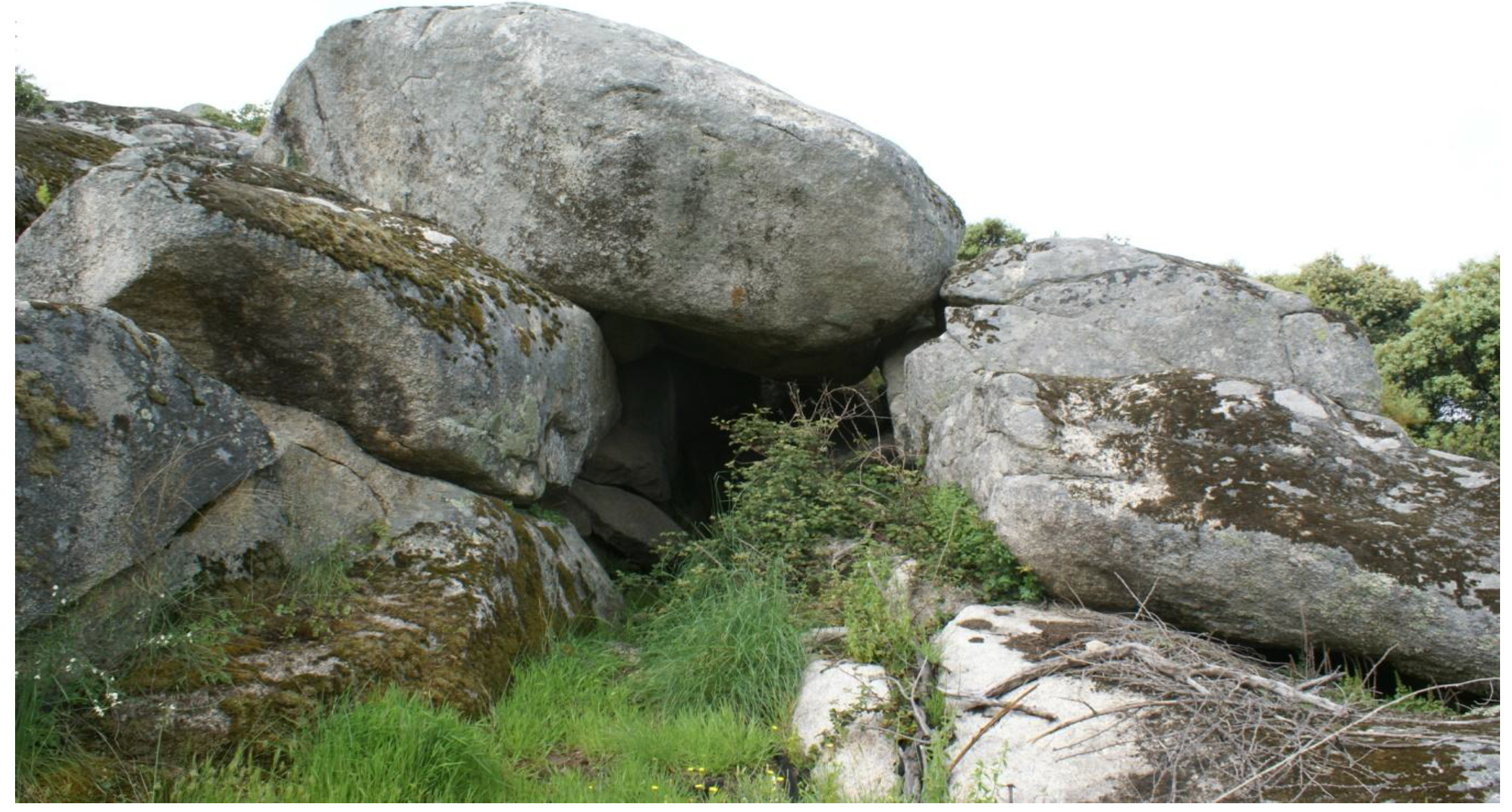
- Sites located in small protected areas inside big fallen blocks in zones with granite outcrops (Figure 4).
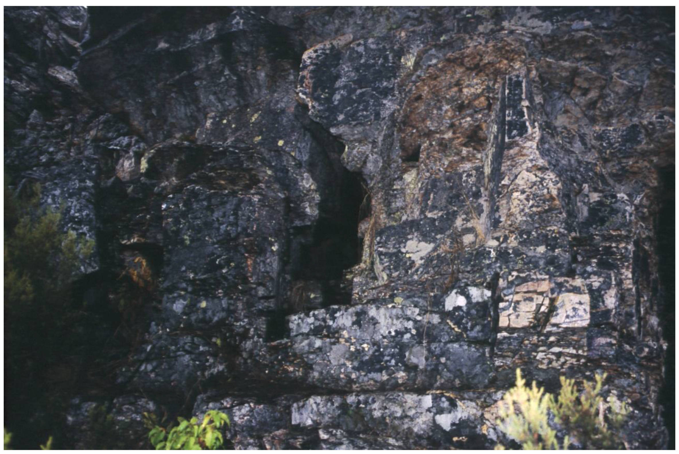
- Small cavities or cracks of small dimensions, most of the time not even large enough to be a shelter for a man. These sites always require an uncomfortable position inside in order to visualize the paintings (Figure 5).
The geological support used, such as granite, quartzite, slate, etc., could have been used to establish another very objective classification. However, this guideline, although taken into account during the analytical process, has not been decisive at any point because it was shown as a useless parameter to identify rock art places. Following this reflection, it could be concluded that, with disregard of the chronological stage, the authors of rock art took advantage of different kinds of geological supports located in their territorial action field for producing rock art, without distinction and without clear selection criteria.
At this point, it was necessary to test the viability of our first hypothesis: the effective control exerted on the territorial resources by prehistoric societies since the Neolithic until the Bronze Age through schematic rock art. In this line, we will take the post-processual approach as a reference to be applied to rock art interpretation, especially from the point of view of landscape archaeology. In this case, prehistoric rock art is considered another element of material culture (for example, classifying it as a similar category as lithic objects).
On this premise, schematic art was integrated in the cultural and socio-economic system developed by human groups occupying a certain territory during a specific period [9]. In this cultural system, schematic rock art plays an outstanding role in the context of trading strategies and taking control of the territory and its resources. In this respect, schematic rock art should be considered a communication system where the figures depicted are part of a symbolic board inside a group of specific locations (shelters), whose meaning is different depending on the chosen location and the type of audience to which the message is transmitted [10].
Without moving from this paradigmatic approach, and with the aim of deeply studying our proposal, we opt to continue with the line followed by Chippindale [11]. This author proposed a model where esthetics, stylistics and geographical aspects are interrelated.
This system helps us to get to an interpretation based on a conscious reiteration regarding the location of shelters in certain geographical contexts with strategic interest. In this interpretation, other constants are recognized: Those related to the typology of figures represented in the shelters, the diachronic limits in their representation, the variability of techniques and pigments used, and the location and visibility of panels where have been represented the figures.
3. Endorsement of the Hypothesis: The Control of Resources through Schematic Rock Art
Once the hypothesis has been posed and the analysis model was established, the only thing missing was to combine all those factors that we have considered before: different chronological stages that we set up in the development of schematic rock art, the different kind of shelters, its territorial distribution, and the different types of figures used in each case. The objective was to know how the symbolic evolution was and how the different figurative types were used, the place that was occupied on the panels, how different types of figures were combined with each other, their scenic composition and their visibility level—also how the panels with depictions interacted with the kind of shelter in each stage, where they were found, taking into account the location, dimensions, orientation, preferential situation, and type of relation with other palimpsests. Finally, this information was connected to the geographical features of the place where the shelter was located.
This led us to create a new classification for the sites where schematic rock art appeared, regarding their functionality:
- Concentration sites: these are enclaves of a big size, which are related to the A type shelter in our morphological classification. They are occupying an important place in the landscape, with outstanding visibility (from and towards the shelter), easy access and with an important strategic value regarding their dominant location in relation to movement zones, especially in fords, mountain passes and hills in mountain regions, or in specific access zones to the narrowed beds of the rivers that flow through the territory.
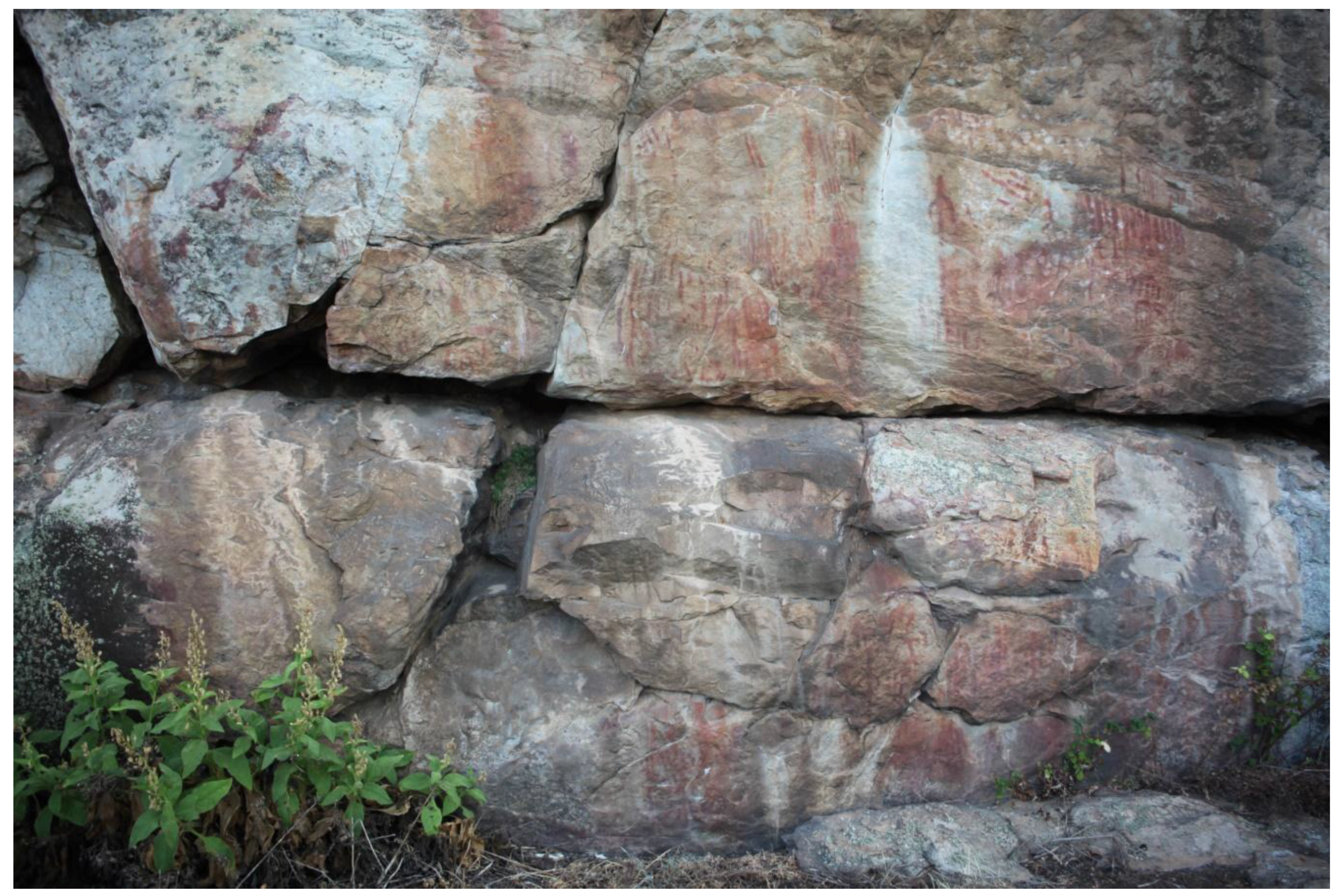
An important number of figures are localized in these sites. They are depicted on panels located indiscriminately (ceiling, central panels, outside, rock cornices, etc.) at different heights and with different orientations. In these cases, there are not clear criteria for a tidy layout, but there is a reiterative desire in order to record the use of the enclave, through depicting as many graphemes as possible. In this sense, iconographic series are diverse. They are human and animal depictions (the first are most common). In addition, an important variety of ‘abstract’ figures appear. Superimpositions are very common, and a huge variety of techniques, pigments and style representations too. All of these aspects are the reflections of a continuous use of these sites through time (Figure 6).
- 2.
- Indication sites: these are the most numerous, together with “movement shelters”. Their sizes are variable and they could perfectly fit into the typology B, C and D in our shelters’ morphological classification. They generally appear on the slope, just in the contact zone between the forest and the rocky line. They are perceptible to the eye at short and medium distances. The visual range from its access zone is wide, although sometimes the vegetation, the undergrowth, or woodlands limit the visibility to and from the shelter. Its territorial distribution avoids the proximity to movement zones or strategic spaces. The quantity of motifs that appear in these shelters is small. These are depicted on a small number of panels that generally do not have many figures and are located in visible places inside the rock art shelter. It is very important because, in this type of rock art shelter, it should be possible to realize the existence of motifs when someone just reached or entered there. The technique used is not very varied. It is usual to see figures made with a regular thick stroke and with the same type of pigment, mainly red. Iconography is simple too: schematic motifs mainly (circles, zigzag, angles, branch forms, spirals, dots, etc.). Human or animal figures appear rarely. The lack of figurative superposition and stylistic regularity suggest a punctuated use of these sites. Thus, it could be deduced that its presence in the territory can be linked to occasional or circumstantial control over some basic resources that are always located in the immediate surroundings of these shelters, essentials for survival in these mountain zones: water sources, hunting and even the shelters themselves (Figure 7).
- 3.
- Movement shelters: this type of shelter is clearly related to strategic places linked to the transit through territory, either through the courses of rivers and streams, or next to mountain passes, fords or hills, which enable communication through the mountain lines. Its size is varied, as well as its visibility range that, usually, should be medium or high, especially those who occupy higher zones. However, the visibility range is reduced in those located in incised gullies and/or slotted river beds. Morphologically, they fit into the B and C shelter types but with a clear predominance of the second over the first. The access to these shelters is often not very difficult, except in some cases when they are associated with inaccessible places in incised gullies, where there are shelters that are literally hanging over the edges, where the access is impossible without climbing equipment.
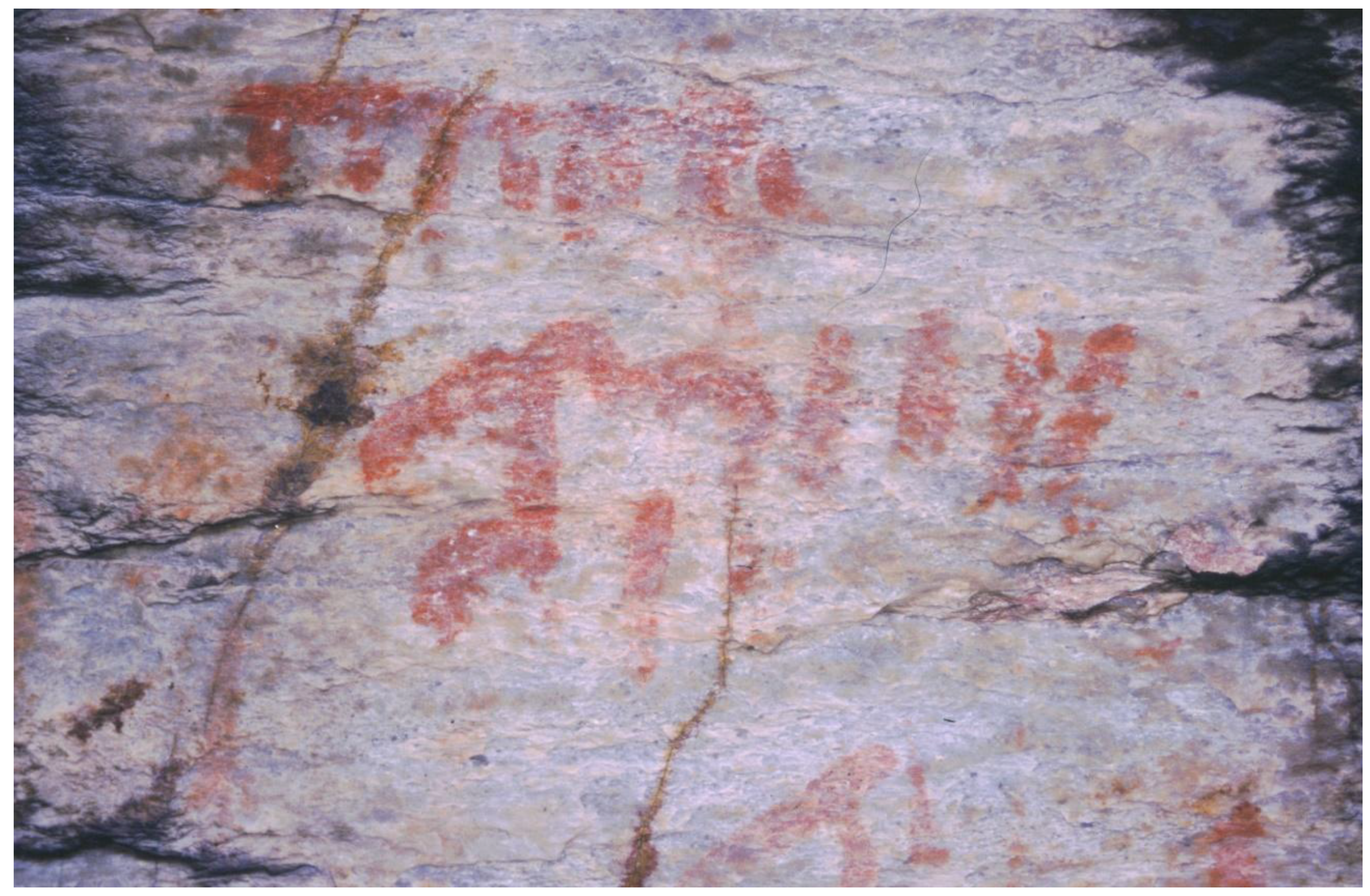
Technically, in fact, there are not too many changes in relation to the previous group: linear strokes and dots are very common motifs in these shelters. The thick ones predominate, although there are some motifs made with thin strokes (the motifs made with thin strokes are more common in this group than in “indication sites”), as well as the use of only one type of pigment (mainly red). Figurative superimpositions are scarce and the iconography is bit varied, although in contrast with the previous group, some kinds of motifs are systematically repeated, especially alignments of vertical strokes. Depictions of anthropomorphous motifs and zoomorphic figures accompanying the symbolic motifs are common. The compositional outlines are varied, from simple alignments of vertical strokes to other, more complex ones, which are clearly structured and hierarchical representations, where the human figure often is present. At the same time, linked figure models are repeated in similar geographical enclaves. One of them, linking a circular or square motif with a zoomorphic motif (usually with comb-shaped figure), seems very meaningful. This association is documented systematically in shelters associated with traffic places, especially mountain passes and hills.
Topographic distribution of panels in these kinds of shelters has a distinctly public nature because they are used only on the most visible surfaces from the outside, even at notable distances. Given that these shelters are clearly linked with communication routes, we could consider that they are authentic landscape marks, indicator signals in mountain passes or tracks associated with minor riverbeds that permitted the access to level zones with abundant grazing land, very adequate for the ranching cabins settlement in their seasonal movements (Figure 8).
Intimacy sites: this is the smallest group and from a morphological point of view, types D and E shelters in the preceding classification are the most common. Generally, these sites are not suitable to use as shelters because their size is very small and a person can hardly fit inside them. Their visibility range is always much reduced and they can even be unnoticed in the landscape around them. These sites do not usually contain a huge number of figures, which are always located on panels in areas that are not very visible. Thus, it is necessary to search carefully on every possible surface and even adopt forced positions in order to view them. A diversity of techniques was used in the creation of the figures, using thick or thin strokes and combinations of both too. Figures appear filled with plain color (mainly red, although black and white also occur) and sometimes bi-chrome figures are depicted (red and black or red and white). The iconography that appears in these shelters is also singular. Zoomorphic representations are rare; however, anthropomorphous figures and schematic motifs (especially sun-shaped figures, bars and dots) are common depictions. In addition, it is possible to find further singular depictions, which do not belong to any established typological classification. Typological associations have not been verified clearly, nor have defined criteria for the panel compositions, which usually have a small number of graphemes and where it is very difficult to find figures superimposed.
From an interpretative point of view, we believe that these are very unique places, used in very specific moments. They are generally used in an individualized way and for an aim not related to daily life, but more to do with ritual and magic. These may be contact places between humans and the supernatural world in which symbolic depictions could be an intrinsic part of the ritual (Figure 9).
4. Diachronic Evolution of a Symbolic Landscape: Ancient, Medium and Recent Schematic Rock Art
According to all the above-mentioned criteria, the landscape of Neolithic rock art during its beginnings (ancient schematic rock art) does not keep reference elements capturing our attention. The shelter is not outstanding, does not stand out above a territory where mountains, rivers, valleys, and plains become survival resources for human groups, which, although being connoisseurs of agriculture and ranching, still have an important dependence on hunting and gathering.
In this first stage, the schematic rock art authors use a variety of pigments (mainly red, but black and white too). “Abstract” figures are the most numerous, while the presences of anthropomorphous and zoomorphic motifs are very low. The iconographical variety is also reduced; the four most common depictions are: linear strokes, sun-shaped figures, circles and wave lines. In the few cases that anthropomorphous depiction appears, they adopt an ancoriforme format (anchor form), “Y” form or double “Y” form.
Panels are usually small since they made use of small surfaces in the rock shelter for the depiction of motifs. It is not possible to realize if some criteria were used to choose the panel location. On these panels, only a small group of graphemes was represented, using usually thick strokes. Superimpositions are very rare.
“Indication sites” are the typology of shelters more clearly associated with this first stage of schematic rock art (ancient schematic rock art), although shelters included under typology “intimacy sites” also can appear.
The rock art represented in these sites has characteristics (technical and stylistic) reflecting an egalitarian lifestyle. It is reflected, for example, in compositional outlines of scenes. In these scenes, the hierarchical organization never appears. It is only possible to see a few figures on these panels, scattered, and most of them with an apparently strong symbolic content. Their size is always similar.
In this model, the control of a large territory is not necessary. The only thing intended to be to achieved is the appropriation of basic resources for subsistence: mainly water and hunting. For this reason, there is a systematic association between rock art shelters and water, springs or seasonal sources of water, as well as hunting grounds or small routes of animals in their movements to water.
The rock art shelter is not perceptible in the landscape. It is necessary to approach it or even to go inside, to perceive that this space, its schematic motifs and the survival resource were linked. The first Neolithic groups used their schematic rock art to exert over them a symbolic appropriation.
Over time, during the Copper Age, social complexity increased. The previous Neolithic landscape uses are changed. Now, the control over survival resources is not enough. The territory of Chalcolithic human groups is large and complex. In this landscape, it is necessary to exert the control over productive activities (agriculture, ranching and metallurgy) as well as over traffic routes. The increase of trade exchange has as a consequence the progressive asymmetry in social relations, and social hierarchy appears [12].
The rock art style for this stage is the medium schematic rock art. Now, the shelters dominate over trade routes and areas with important resources, mainly metallurgical. These shelters are bigger and more visible. “Movement shelters” and “concentration sites” are the typologies that fit better into this new stage.
Panels are bigger in size. They are located in clearly visible places in the shelter, especially over the central areas on the back walls. The number of figures depicted on the panels increases and figurative superimpositions are common. Rock art scenes begin to be perceived. Horizontal scene patterns are the most common ones, although there are others more complex: vertical, triangular, and also circular. Hierarchical relationships are shown by differences in the size of motifs and their preferential position on the panel.
Figures made with red pigments and using thick strokes are clearly dominant. The typologies that appear in these shelters suffer an important change: decreases in the percentage of “abstract” motifs and growing anthropomorphous—these are the main protagonists in this new stage—and zoomorphic figures, all of them with varied formats. Those formats range from the most naturalistic ones to the less detailed depictions.
All this is in tune with a process that has been clearly marking this chronological period. It has been defined by some researchers as “ideological process of anthropomorphization”. The prevalence of human figures (mainly male) is not only shown in schematic rock art, but also on other ways of expression as portable art (anthropomorphous idols made of stone or bone), which have a special protagonism at the end of the third millennium BCE. These human representations (schematic rock art and portable art) extend geographically over much of the Iberian Peninsula. All this is the result of a process of social hierarchization, which is shown through rock art by means of figures to appear with elements of status and prestige ([13]: 356).
During the Bronze Age, the hierarchization process was intensified. It had been developed along the previous stage [14] and now new strategic settlements appear to intensify the territorial control [15]. All this happens in the middle of an outlook, which, on a peninsular scale, has very varied versions of a phenomenon of realignment of population and social, economic, and ideological changes [16].
Obviously, as happened with previous medium schematic rock art, the rock art of this stage, recent schematic rock art, was not indifferent to all the changes produced. The same shelters used in previous stages (“movement shelters” and “concentration sites”) were also used in this new stage. Motifs of this third stage usually overlap previous figures. Logically, recent schematic rock art maintains the characteristics of the previous stage (morphological, technical, and compositional patterns).
Thus, the task of identifying the graphemes of this new phase is really complicated. Thin strokes are more used than thick ones. They have been done with instruments that allow authors to make more detailed figures. The darker and denser pigment tones (mainly red) are the most common. However, the most representative element of this new rock art stage is the appearance of new iconographic models whose parallels are in the peninsular archaeological objects clearly ascribed to the Bronze Age (chariots, horned helmets, headdresses, swords, shields, etc.) and whose chronology, according to the main researchers, seems to reach an important development throughout the Bronze Age ([17]: 56; [18]: 34–71; [19]: 252), although they seem to become widespread mainly at the late Bronze Age [20].
In addition, some stylistic innovations are recognized in recent schematic rock art. The main one is about anthropomorphous depictions. Heads, trunks and arms, which usually show the hands and the fingers, were represented from a frontal perspective. The rest of the figures, legs and feet, are clearly individualized in profile.
With recent schematic rock art ends our schematic rock art sequence. It is closing an artistic and cultural cycle that has been in force for 4000 years. However, it does not mean that rock art was interrupted at this moment, because the Iberian Peninsula then witnesses the introduction of Iron Age rock art. It appears with an unusual force at the beginning of the first millennium BCE and continues until Roman conquest, using preferably petroglyphs as the method to create rock art.
The aim of this article is not to define the characteristics of this new artistic cycle, but characterize the schematic rock art style, emphasizing that, with the end of the Bronze Age, ends the schematic rock art, which started in the first period of the Neolithic with a distinctive personality. Schematic rock art is different from previous hunter-gatherer rock art styles (Levantine rock art, pre-schematic rock art) [21,22]. During its term, schematic rock art evolved. Thus, we were able to establish three stages: ancient, medium and recent schematic rock art, each one with particular characteristics regarding shelter distribution on the landscape, technique, style and iconography.
At the beginning of the Iron Age, a new chronological and cultural framework was accompanied with a new way of understanding rock art, which is perceived by changes in all the orders: technical, stylistic, thematic, etc. A new artistic style appears with a strong personality, although hardly defined yet. This cycle is, in any case, different from schematic rock art. Therefore, we think that schematic rock art should be clearly separated from the Iron Age rock art because both cycles give answers to different realities, and both of them should be studied and analyzed independently.
Acknowledgements
All sources of funding of the study should be disclosed. Please clearly indicate grants that you have received in support of your research work. Clearly state if you received funds for covering the costs to publish in open access.
Conflicts of Interest
The author declares no conflict of interest.
References
- H. Collado. Arte rupestre en la cuenca del Guadiana: El conjunto de grabados del Molino Manzánez (Alconchel-Cheles). Memorias de Odiana vol. 4; Beja: EDIA, 2006. [Google Scholar]
- H. Collado. “De H. Breuil a nuestros días: 80 Años de investigación en el arte rupestre esquemático de Extremadura. Los abrigos de la Sillá (Hornachos, Badajoz).” In Proceedings of the Actas del XXIV Congreso Nacional de Arqueología, Cartagena, Colombia, 1999; vol. 1, pp. 289–98.
- H. Collado, and M. Simoes de Abreu. “Post-Palaeolithic Rock Art in the Iberian Peninsula (1995–1999).” Rock Art Studies News of the World 2 (2003): 25–35. [Google Scholar]
- I. Domínguez, H. Collado, and J. J. García. “Un siglo de investigación para la pintura rupestre esquemática de la provincia de Badajoz. Evolución de la metodología y nuevas aportaciones.” In Proceedings of the Actas del II Congreso Arte Rupestre Esquemático en la Península Ibérica, Comarca de los Vélez, España, 5–8 Mayo 2010; pp. 279–86.
- A. Caballero Klink. La Pintura Rupestre Esquemática de la Vertiente Septentrional de Sierra Morena (Provincia de Ciudad Real) y su Contexto Arqueológico. Ciudad Real: Provinz, 1983. [Google Scholar]
- H. Collado. “Arte rupestre prehistórico en Extremadura: 1997–2006.” In Arte Prehistórico al Aire Libre en el sur de Europa. 2009, pp. 287–322. [Google Scholar]
- J. J. García. “La pintura rupestre esquemática en la provincia de Cáceres.” Extremadura Arqueológica 7 (1997): 119–40. [Google Scholar]
- H. Collado. Arte rupestre en la cuenca del Guadiana: El conjunto de grabados del Molino Manzánez (Alconchel-Cheles). Memorias de Odiana vol. 4; Beja: EDIA, 2006. [Google Scholar]
- J. Martínez. “Pintura rupestre esquemática: El panel, espacio social.” Trabajos de Prehistoria 59 (2002): 1–23. [Google Scholar] [CrossRef]
- R. Bradley. Rock Art and the Prehistory of Atlantic Europe: Signing the Land. New York: Routledge, 1997. [Google Scholar]
- C. Chippindale. “From millimetre up to kilometre: A framework of space and of scale for reporting and studying rock art in its landscape.” In The Figured Landscapes of Rock Art. Looking at Pictures in Place. Cambridge: Cambridge University Press, 2004. [Google Scholar]
- F. Nocete. Tercer Milenio Antes de Nuestra Era. Relaciones y Contradicciones Centro/Periferia en el Valle del Guadalquivir. Barcelona: Bellaterra, 2001. [Google Scholar]
- J. J. Enríquez. “Nuevos ídolos antropomorfos calcolíticos de la Cuenca Media del Guadiana.” Spal 9 (2000): 351–68. [Google Scholar] [CrossRef]
- V. Hurtado. “Los inicios de la complejización social y el Campaniforme en Extremadura.” Spal 8 (1999): 47–83. [Google Scholar] [CrossRef]
- I. Pavón. El Tránsito del II al I Milenio a.C. en Las Cuencas de los Ríos Tajo y Guadiana: La Edad del Bronce. Cáceres: Universidad de Extremadura, 1998. [Google Scholar]
- M. L. Ruiz-Gálvez. La Edad del Bronce, ¿Primera Edad de Oro de España? Barcelona: Crítica, 2001. [Google Scholar]
- M. Varela. “Arte rupestre do vale do Tejo (Portugal).” Semiótica del Arte Prehistórico Serie Arqueológica 18 (2001): 53–88. [Google Scholar]
- F. J. Costas, and P. Novoa. Los Grabados Rupestres de Galicia. Coruña: Monografías del Museo Arqueolóxico e Histórico de A Coruña, 1993, vol. 6. [Google Scholar]
- J. A. Gómez Barrera. “Manifestaciones de la facies esquemática en el centro y norte de la Península Ibérica.” ETF 5 (1992): 231–64. [Google Scholar]
- M. L. Ruiz-Gálvez. Ritos de Paso y Puntos de Paso. La ría de Huelva en el Mundo del Bronce Final Europeo. Madrid: Complutum Extra, 1995. [Google Scholar]
- H. Collado, and J. J. García. “Pintura rupestre esquemática sobre granito en la provincia de Cáceres: Los ejemplos de la Cueva Larga del Pradillo y Los Canchalejos de Belén (Trujillo).” Zephyrus 64 (2009): 19–38. [Google Scholar]
- H. Collado, and J. J. García. “10,000 años de arte rupestre. El ciclo preesquemático de la Península Ibérica y su reflejo en Extremadura (España).” In Actas del Congreso IFRAO 2009. Piaui: Parque Nacional de la Sierra de Capivara, 2010, vol. 4, pp. 1167–92. [Google Scholar]
Figure 1.
Linus Shelter, Monfragüe (Cáceres).
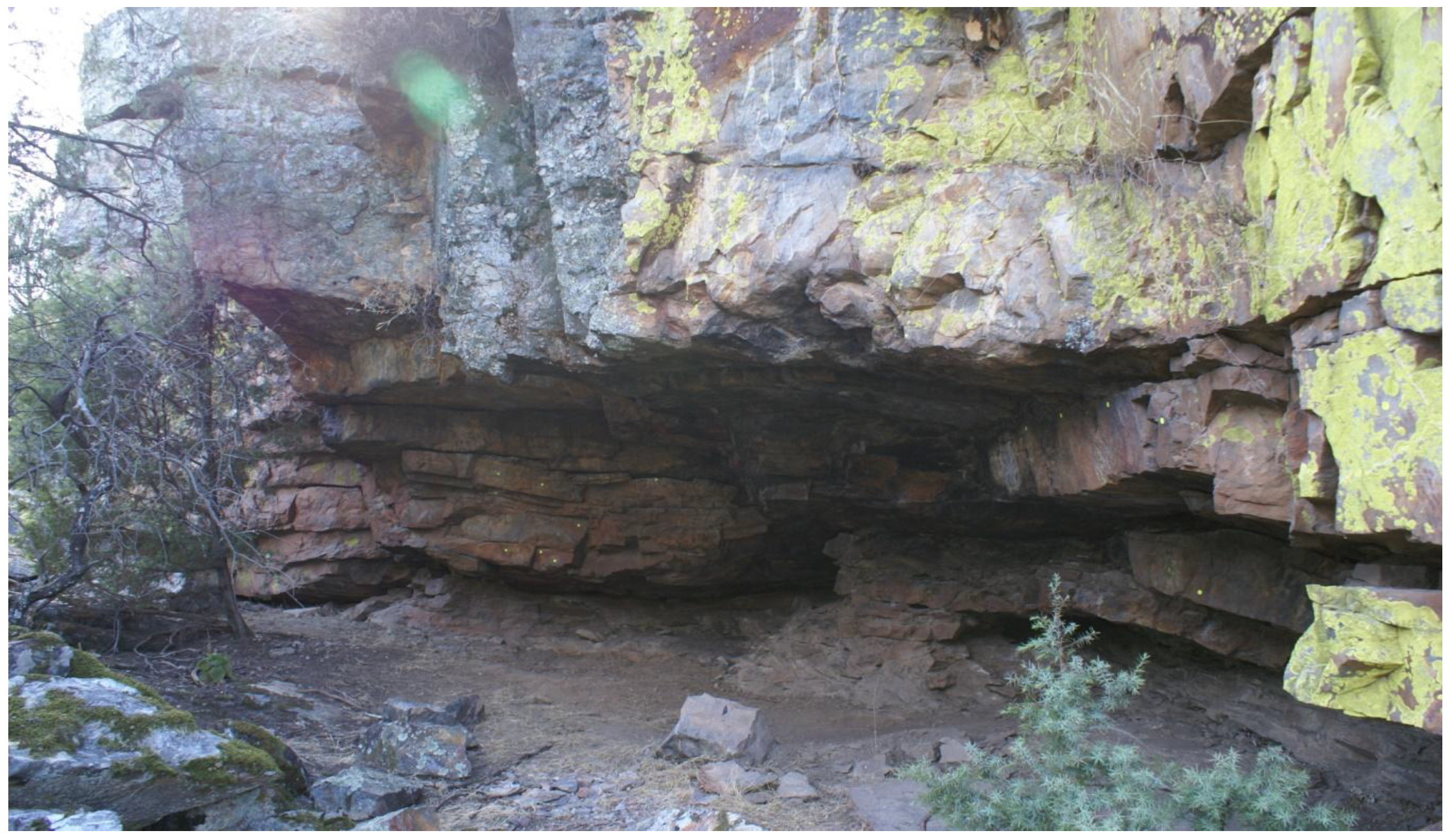
Figure 2.
Amarillo Shelter, Helechal (Badajoz).

Figure 3.
Alía Shelter, Alía (Cáceres).
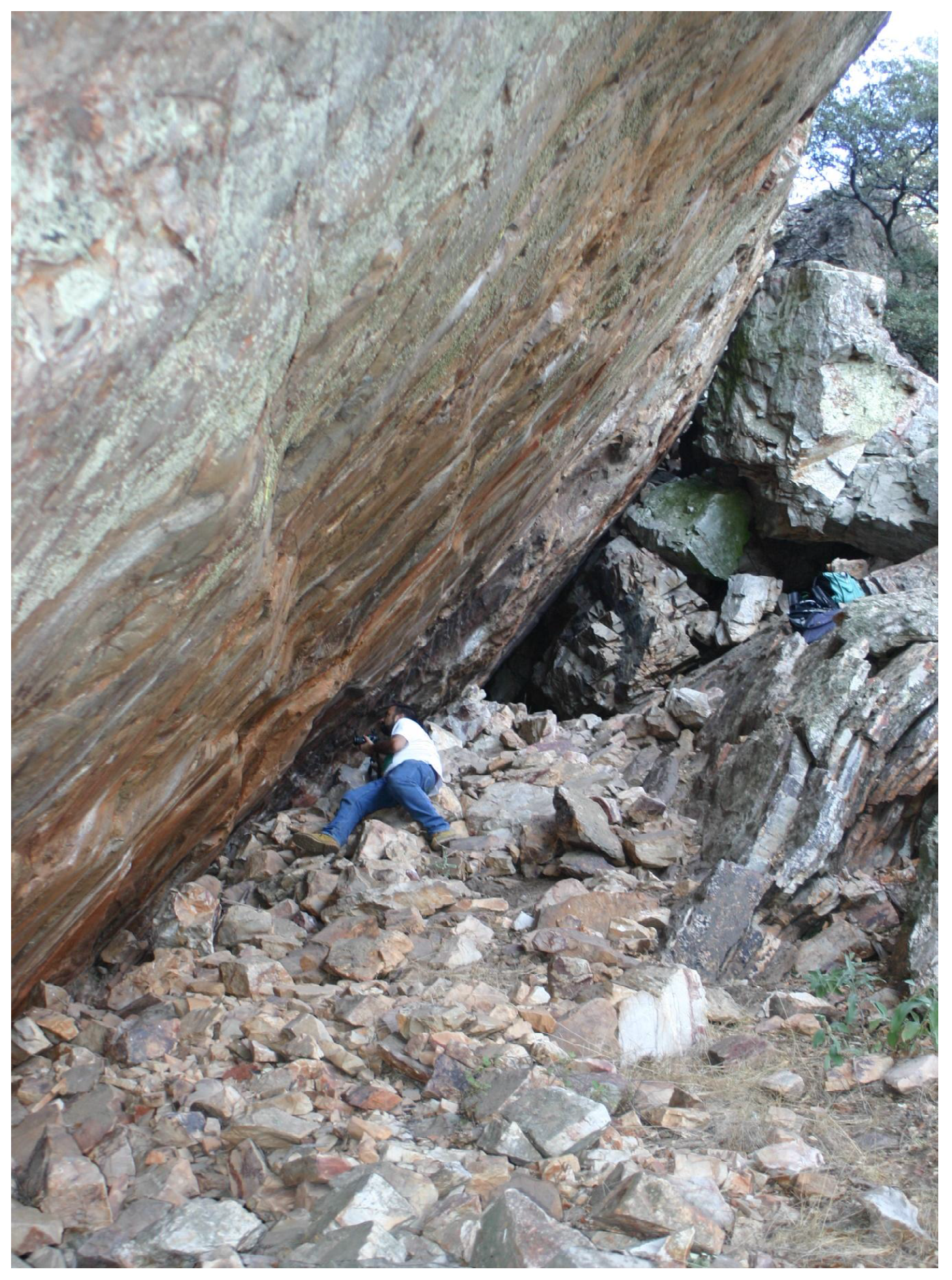
Figure 4.
Pradillo Shelter, Trujillo, (Cáceres).

Figure 5.
Noe Shelter, Monfragüe (Cáceres).

Figure 6.
Juanita Shelter, Oliva de Mérida (Badajoz).

Figure 7.
Cuevas 3 Shelter, Hornachos (Badajoz).

Figure 8.
Friso del Terror. Monfragüe National Park (Cáceres).
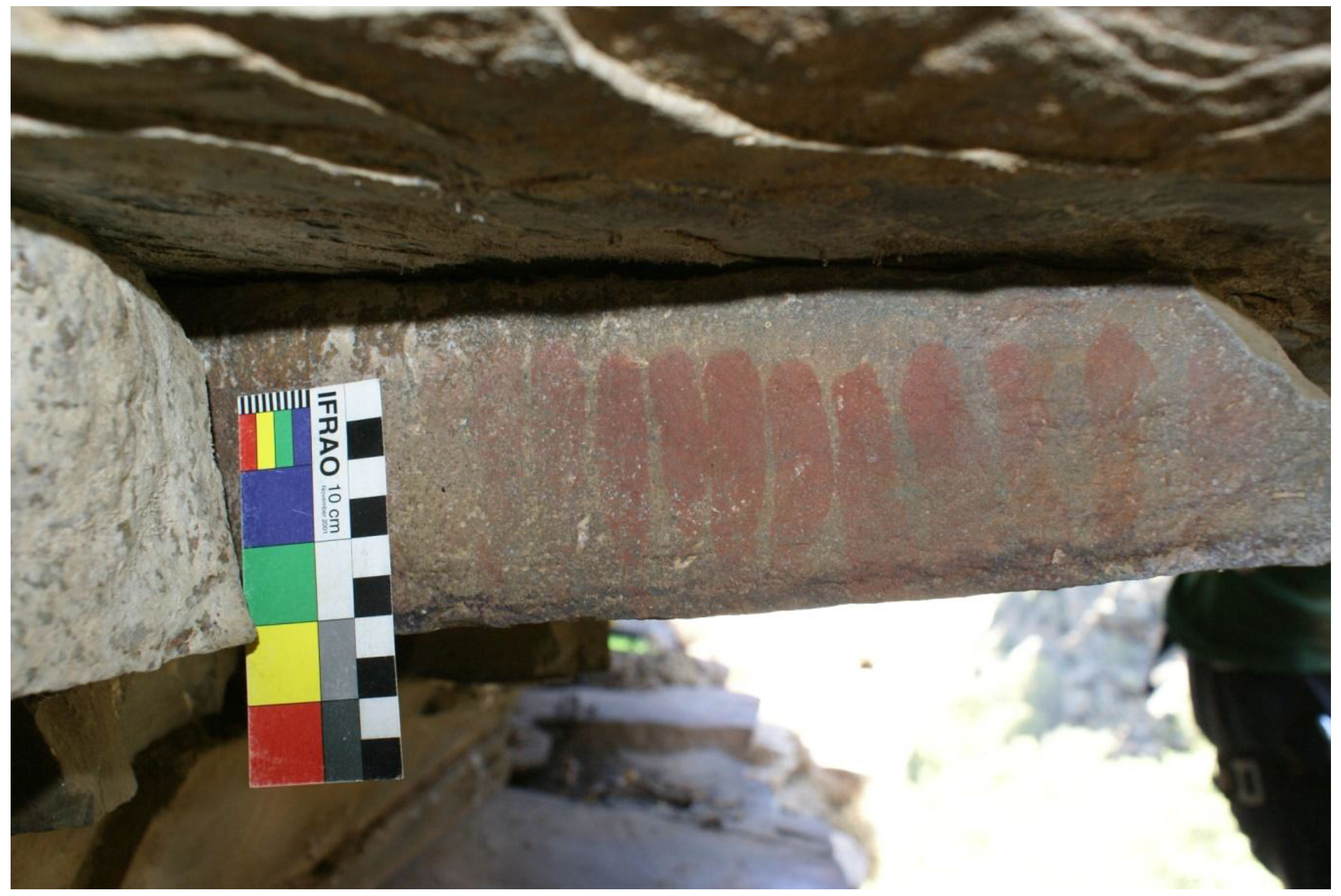
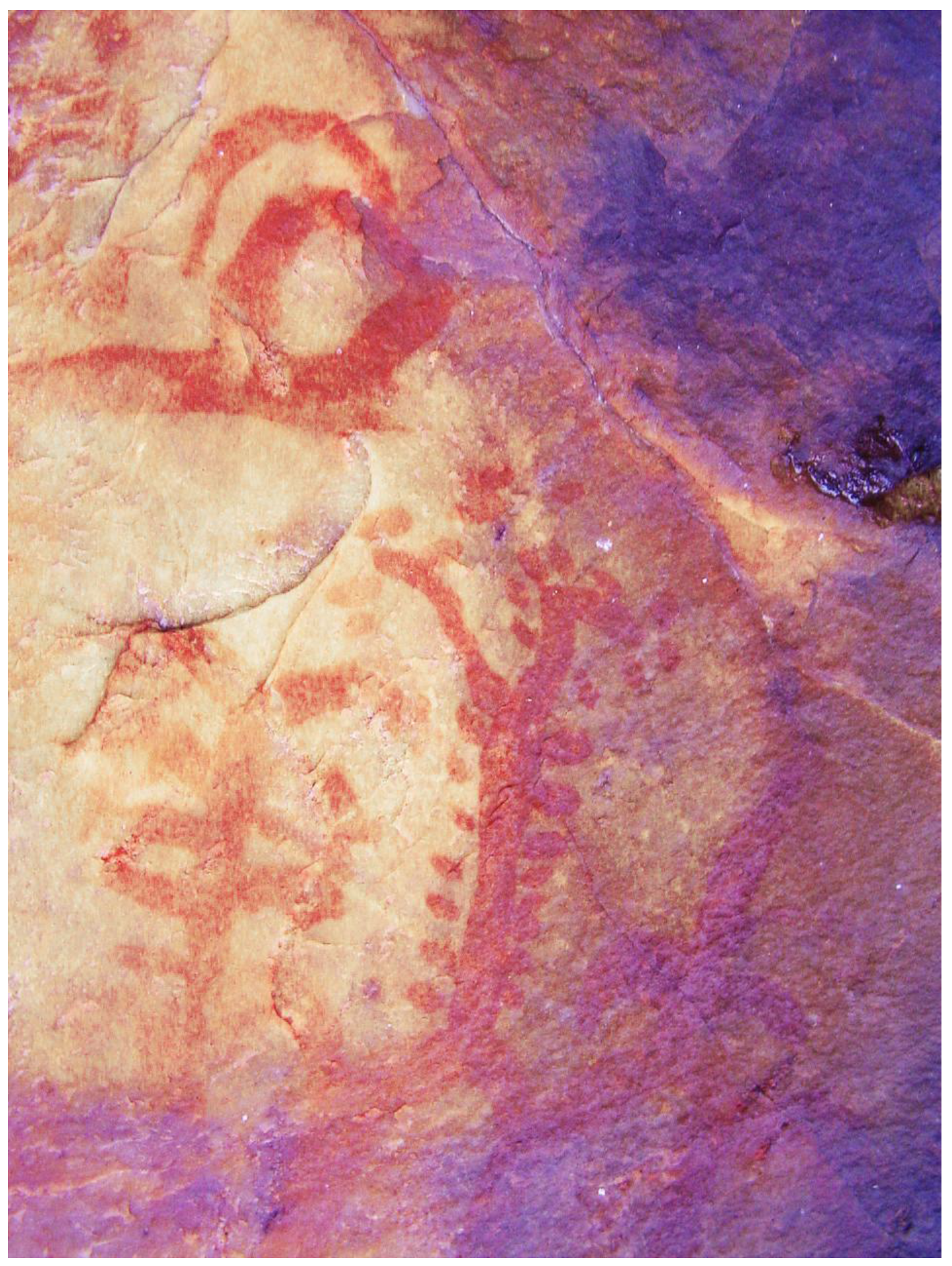
Figure 9.
Límite Shelter, Monfragüe (Cáceres).
© 2016 by the author; licensee MDPI, Basel, Switzerland. This article is an open access article distributed under the terms and conditions of the Creative Commons Attribution (CC-BY) license (http://creativecommons.org/licenses/by/4.0/).
Share and Cite
MDPI and ACS Style
Collado Giraldo, H. A Mark along the Way: Schematic Rock Art and Communication Routes. Arts 2016, 5, 6. https://doi.org/10.3390/arts5030006
AMA Style
Collado Giraldo H. A Mark along the Way: Schematic Rock Art and Communication Routes. Arts. 2016; 5(3):6. https://doi.org/10.3390/arts5030006
Chicago/Turabian StyleCollado Giraldo, Hipólito. 2016. "A Mark along the Way: Schematic Rock Art and Communication Routes" Arts 5, no. 3: 6. https://doi.org/10.3390/arts5030006
Note that from the first issue of 2016, this journal uses article numbers instead of page numbers. See further details here.