Watching the Beach Steadily Disappearing: The Evolution of Understanding of Retrogressive Breach Failures


1
Deltares, Department of Marine and Coastal Management, PO Box 177, 2600 MH Delft, The Netherlands
2
Independent Researcher, 4000 Brisbane, Australia
3
Cerema, 33200 Bordeaux, France
*
Author to whom correspondence should be addressed.
J. Mar. Sci. Eng. 2019, 7(10), 368; https://doi.org/10.3390/jmse7100368
Submission received: 27 August 2019
/
Revised: 3 October 2019
/
Accepted: 11 October 2019
/
Published: 17 October 2019
(This article belongs to the Section Coastal Engineering)
Abstract
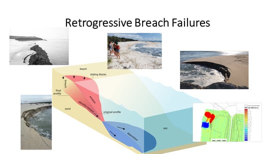
:Retrogressive breach failures or coastal flow slides occur naturally in the shoreface in fine sands near dynamic tidal channels or rivers. They sometimes retrogress into beaches, shoal margins and riverbanks where they can threaten infrastructure and cause severe coastal erosion and flood risk. Ever since the first reports were published in the Netherlands over a century ago, attempts have been made to understand the geo-mechanical mechanism of flow slides. In this paper we have established that events, observed during the active phase, are characterized by a slow but steady retrogression into the shoreline, often continuing for many hours. This can be explained by the breaching mechanism, as will be clarified in this paper. Recently, further evidence has become available in the form of video footage of active events in Australia and elsewhere, often publicly posted on the internet. All these observations justify the new term ‘retrogressive breach failure’ (RBF event). The mechanism has been confirmed in flume tests and in a field experiment. With a better understanding of the geo-mechanical mechanism, current protection methods can be better understood, and new defense strategies can be envisaged. In writing this paper, we hope that the coastal science and engineering communities will better recognize and understand these intriguing natural events.
1. Introduction
Retrogressive breach failures (RBF events), often more loosely named ‘coastal flow slides’ or just ‘flow slides’, are a type of underwater slope failure with a final very gentle run-out angle. This type of geohazard occurs naturally in fine sandy or silty subaqueous sediments on river and tidal channel banks, beaches, and tidal flats. When they retrogress into the foreshore above water, their progress can be directly observed (Figure 1).
The failure mechanism itself, powered by gravity, is complex and involves a geo-mechanical component within the water-saturated sand skeleton and an associated hydrodynamic component which carries suspended sand grains away before they resettle [1,2]. Sediment is released steadily over hours from the surface of an almost vertical, retrogressing submerged sand wall and mixes completely with ambient water to generate a sustained turbulent density current flowing downslope. As this current encounters more gentle slopes it loses momentum and sand grains settle in layers on the seabed.
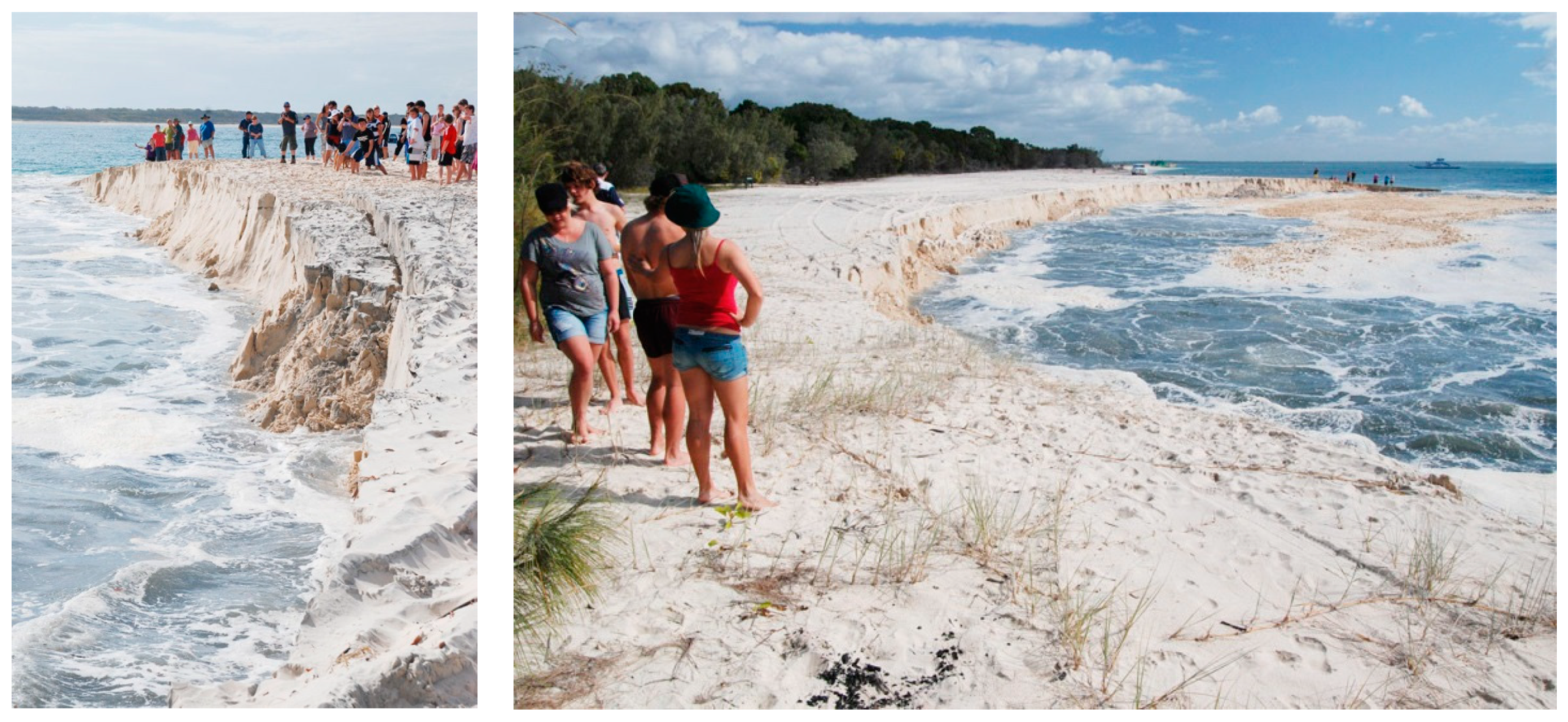
Flow slide events are seldom witnessed directly, since the active phase is short lived, they do not occur frequently and often remain completely submerged. They only sometimes retrogress into the beach or bank. Above the water table, in generally moist unsaturated sand, blocks tear off and fall into the water as they are undermined by the retrogressing sand wall (Figure 2). This extra sand further boosts the density current. At termination, a characteristic amphitheater-shaped head scar and a fan or tongue of newly deposited sand remain. Flow slides are not triggered by storms, waves, or earthquakes; they are a category of geohazard that is associated more with coastal tidal channel or riverbank erosion. They can also be associated with human activities in the submarine environment such as sand mining, dredging, and sand deposition at sea. They occur at many locations worldwide.
Research into these events is on the crossroads of several scientific specialties (geology, geotechnical engineering, geomorphology, and hydrodynamics), which has led to confusion and isolated research lines. In addition, reports over many years have been written in three languages (Dutch, German, and English) so information sharing has been difficult. Many historical descriptions of flow slides are available from the Netherlands. The term ‘coastal flow slide’ was introduced by Koppejan et al. [3]; with ‘flow’ in a hydrodynamic sense, as a sustained density current and ‘slide’ in a geotechnical sense, as a type of slope failure or instability in coastal settings. In Section 2 we present a new review of some original 19th century reports on historic events that reveals essential discrepancies with current geotechnical theory developed in the early 20th century. More recently, the authors have been involved in research on coastal erosion issues in their respective countries Australia, Netherlands and France, as described in Section 3.1 to Section 3.4. Here, for the first time, flow slides have been recognized and recorded on video during their active phase, revealing so far unknown information on speed and duration of the events.
In this paper, we use the terms ‘retrogressive breach failure’ (RBF event), [1], and ‘coastal flow slide’ as synonyms. This is not strictly true as the more general term ‘flow slide’ is sometimes used to describe any mass wasting or slope failure process other than shear or slip failures, such as (retrogressive) slumping, bank or beach collapses, earth and debris flows, earthquake-induced liquefaction, and landslides in sub-aerial muddy and water-saturated sediments like tailings dam failures. Our preferred name is ‘retrogressive breach failure’ (RBF event) because it uniquely and unambiguously describes the failure mechanism.
RBF events are still poorly recognized and understood by the coastal science and engineering communities, even though they can pose considerable risks to coastal and submerged infrastructure and sometimes to public safety. Often, they are misdiagnosed as shear slides, liquefaction failures or simply as ‘severe erosion’. Popular names given by the press are ‘sinkhole’, ‘beach collapse’, ‘underwater landslide’, or ‘channel slump’. Larger events are newsworthy because of their spectacular nature and, hence, are often reported in the media. In recent decades, active events have been opportunistically videoed and posted on the internet and these have become a valuable source of new information. We have recognized and explained the mechanics of these case studies (see Section 3.5). Table 1 gives an overview of events worldwide with properties, date, geographic coordinates and internet links.
A diagnostic feature of an RBF event is the high, near vertical subaqueous sand wall, which retrogresses steadily upslope during the active phase. This wall is called a ‘breach’ and the process ‘breaching’ [4]. Negative pore pressure within the sand skeleton behind the breach causes suction, which stiffens the deposit (strain hardening) and so resists a wall collapse. This will be explained further in Section 4. As a result of field observations and a better understanding of the physical mechanism of RBF events presented in this paper, it will be possible to develop realistic numerical models and design more effective mitigation measures. This is further discussed in Section 5.
2. Historical Overview of the RBF Phenomenon
2.1. History of the Flow Slide Threat in the Netherlands
Zeeland, the southwestern delta region of the Netherlands, has suffered from the threat of flooding for centuries. Here, the loss of land and lives due to flow slides destroying dikes and flood protection works has been high. Many mitigation measures have been trialed but it is only since the completion of the Delta Works program in 1987 that dike collapses have been substantially overcome [5].
Post-event flow slide damage profiles have been measured for almost two centuries [6]. The occurrence of flow slides can be easily recognized today in the typical hourglass shaped differential pre- and post-event bathymetry in ocean floor and coastal zone surveys. Figure 3 shows the erosion and deposition pattern of a completely subaqueous flow slide event in a steep channel bank eroded by tidal currents near the Eastern Scheldt Barrier [7,8]. Van Dijk [9] assessed a large number of previously unnoticed subaqueous shoal margin collapses from historical bathymetry data of the Western Scheldt.
De Bruin and Wilderom [10] collated historical information on the fate of polders related to dike failures and the struggle with the sea. We expand on this history since it supports present day observations and the modern understanding of flow slides. In the 18th and 19th century, many polders in Zeeland, reclaimed in previous centuries from slowly aggrading marshlands, were lost again due to the gradually advancing tidal channels and flow slides attacking embankments. Adequate protection became harder and more expensive and often retreat (building a new sea dike behind an existing one, called ‘inlaagdijk’ in Dutch) was the only option. In those days, heavily protected groynes (‘fixed points’) were built to redirect currents away from the shore, a strategy that failed since flow slides occurred in the unprotected areas between them (see Figure 4).
A hot spot for flow slides was the northern shore of the island Noord-Beveland where the strong tidal currents of the Eastern Scheldt approach the coast. Here, more than one kilometer of marshland was eroded within a century and finally the polder dikes came under direct threat [11]. A contemporary eye witness report documents the nature of the process of a dike collapse in 1864 [12] (translated from Dutch): ‘At 5:30 in the morning of the 10th of March 1864 the headman of the polder laborers noticed that already 4.5 ha of the bank area was taken into the deep and the water level already penetrated 15 m into the toe of the dike. The slide extended in both eastern and western directions. Blocks of soil of 2 to 8 m3 were torn off and tumbled down twisting into the emerging depth. The progression of this process diminished gradually and became less significant after 9 o’clock. Catastrophes like this usually happen at low tide. At 9.15 in the evening of 9th of March 1864 it was low tide and it should not remain unnoticed that one of the roommates of the headman started to hear from this time on and the whole night further, the sound of big blocks of soil falling into the water. Apparently, the event took place in the time between two successive ebb tides.’
While various 19th century authors described flow slides in detail in Dutch, the phenomenon remained unknown to the mostly German- and English-speaking international scientific communities in those days. Koppejan et al [3] explain the ‘Luctor et Emergo’ (I struggle and emerge) history of Zeeland and introduced the English term ‘coastal flow slide’ for the first time. They describe a typical Zeeland flow slide of that time: ‘A Zeeland flow slide is a gradual process where at intervals of a few minutes soil masses slide downward and flow out. Observation however is only possible after the disturbance has progressed to above the waterline and a steep wall has been formed here. Then at a place one or more meters landwards cracks appear about 10 m long, after which the soil mass in front starts to slide. In this way the slides go on, progressing about 50 m per hour. On the landward end of the slide the soil above and a little below the waterline may keep a very steep slope. The duration of the complete process varies from a few hours to a day.’
This report again clearly describes the slow retrogressive nature of events, all very similar to present day observations elsewhere in the world. Van Rummelen [13] calls the phenomenon ‘coast’ or ‘dike falls’ and indicates that they, not storm surges such as the disastrous 1953 flood event, are the major cause of the immense loss of land in the province of Zeeland over the past two centuries. The poor condition of many dikes due to the lack of maintenance during and after WWII also contributed to the problem.
2.2. Terzaghi and the Origin of the Term ‘Zettingsvloeiing’
The concept of the flow slide mechanism as a slope instability dates back to the origins of modern geotechnical engineering. Friedrich Müller, a German engineer, studied the coastal engineering works in Zeeland in the late 19th century, in order to later apply this knowledge in the German province of Schleswig-Holstein. In his report, published in 1898 [14], he described the phenomenon of coastal bank failures, especially observed at the northern coast of the island of Noord-Beveland adjacent to the large Roompot channel of the Eastern Scheldt, referring to detailed descriptions written in Dutch. He named this type of bank failure in German ‘Fälle’ or ‘Uferfälle’ (bank falls), a translation of the original Dutch concept ‘vallen’ or ‘oevervallen’. He distinguished this type of failure, characterized by a very gentle post event run-out slope and a typical amphitheater-shaped head scar, from ‘Abschiebungen’ or ordinary shear failures.
Karl Terzaghi, known as the ‘father’ of modern science-based geotechnical engineering, studied the work of Müller, available to him in his native German. He categorized the described ‘Sandfälle’ (sand falls) in Zeeland as an example of a type of instability that he called ‘Setzungsfließung’ or subsidence induced liquefaction in his famous 1925 handbook ‘Erdbaumechanik’ [15]. In a classification of land slide mechanisms, Terzaghi considered liquefaction as a type of slope failure in granular material, associated with subsidence, densification, and saturation, and, hence, reduction of effective stress, as in quicksand. In German, Setzungsfließung is still used in the context of a subaerial landslide (Rutschung) related to subsidence in unsaturated soil, for example after heavy rainwater infiltration resulting in saturation, excess pore water pressure (liquefaction), and associated sudden collapse, as recently described by Gudehus et al. [16].
Terzaghi [15] included a typical profile of what he considered to be a liquefaction flow slide (Figure 5) referring to Müller [14]. According to his description it was located at Noord-Beveland, a former island in Zeeland but he did not specify the exact location or date of the event. Examining more closely Müller’s original diagrams (‘Tafeln’, which are not included in recent reprints of the book) in the Middelburg library we noticed that Terzaghi’s Figure 5 actually shows the cross section of a large flow slide and dike collapse event that took place on 11 August 1881 at the Oud Noord-Bevelandse Polder, on the northern coast of the island (see Figure 6).
In Figure 6 and Figure 7a the original diagrams of Müller [14] are shown. Figure 7b shows the reconstructed location of this event on a 2018 Google Earth image. As can be seen in Figure 7 the shape of the northern coastline of Noord-Beveland today still shows the remains of lost dikes. The dikes were never repaired and the former polders (‘inlagen’) have been permanently lost, leaving here a wetland with salt marshes, today called the Oesterput. The encroachment of the Eastern Scheldt now has been arrested by the completion of the Delta works in 1987.
Terzaghi cites a geological report, which may have stated that the event took place with ‘catastrophic speed’ and was announced by a ‘muffled, thunder like roar’. The description in Müller may have given Terzaghi the impression of a rapid landslide event like a rock- or mud avalanche (‘Bergsturz’ or ‘Erdrutschung’ in German), common in mountainous landscapes. The short time and high speed reported by Terzaghi for this flow slide event however was definitely not reported in the original eyewitness descriptions. In the English version of his handbook ‘Soil Mechanics in Engineering Practice’ [17], Terzaghi writes: ‘Slides can occur only in loose saturated sands. They are caused by spontaneous liquefaction. The disturbance required to release a sand slide can be produced either by a shock or by a rapid change in the position of the water table. Once the movement has started, the sand flows as if it were a liquid and does not stop until the slope angle becomes smaller than 10° (about 1:6). The sand slides along the coast of the island of Zeeland in Holland belong in this category. The coast is located on a thick stratum of fine quartz sand that consists of rounded grains. The slope of the beach is only 15° (about 1:4). Yet, once every few decades after exceptionally high spring tides, the structure of the sand breaks down beneath a short section of the coastal belt. The sand flows out and spreads with great speed in a fan-shaped sheet over the bottom of the adjacent body of water.’ (refers to Figure 5).
The 1864 eyewitness report [12] states that the event took place over about 12 hours and was characterized by slow retrogression. The sound that could be heard all night came from blocks of sand falling into the water after the event arrived at the shoreline. A ‘catastrophic’ or ‘great speed’ is not mentioned by Müller, nor in the older original Dutch publications.
We conclude that the process was not like a landslide or an avalanche taking place in only minutes and the sound was not related to the speed of the process. Terzaghi had never read the original publications in Dutch and never personally witnessed the phenomenon in Zeeland, so he incorrectly diagnosed the flow slides or ‘Sandfälle’ in Zeeland to be a type of rapid liquefaction landslide he called ‘Setzungsfließung’. His hypothesis is not supported by the original publication of Müller to which he refers. Terzaghi’s explanation was adopted in 1940 by Keverling Buisman, the founder of the Soil Mechanics Laboratory in the Netherlands in his handbook [18]. He introduced the Dutch term ‘zettingsvloeiing’ as a translation of the German word ‘Setzungsfließung’. Following Terzaghi, he supported the hypothesis of the liquefaction mechanism as applied to the flow slides in Zeeland but did not further elaborate on this concept in his book.
2.3. Liquefaction or Breaching?
In the Dutch water management magazine OTAR in 1943, Barentsen [19], after having read Keverling Buisman’s book disputed the mechanism of liquefaction for the observed coastal bank failures, since it was not in agreement with the observed slow retrogression. Several very large flow slides occurred during WWII. He proposed that a flow slide would be better described by ‘a number of successive seepage slides’ (‘kwelafschuivingen’ in Dutch), coming close to the concept of RBF events. A long debate in OTAR followed.
After the 1953 floods, the Delta program was started and in the 1970s and 1980s research by the Department of Public Works and Water Management in the Netherlands focused on ways to prevent flow slide damaging the bank protection works of the sea dikes in Zeeland and the Storm Surge Barrier foundations in the Eastern Scheldt mouth. At that time, the flow slide mechanism was generally believed to be static liquefaction and despite Barentsen’s arguments the term ‘zettingsvloeiing’ came into use as a synonym for coastal flow slide [20,21]. Research for the Delta works in large scale flume tests in the 1970s and later, focused on rapid liquefaction failures and prevention measures in loosely packed sands [22,23,24]. Flow slides like those observed in Zeeland however, have never been demonstrated in flume tests.
In the early 1970s a research program was initiated in the Netherlands on dredging processes [25,26]. One of the first observations with suction in fine, densely packed, saturated sand in small-scale flume tests was the slow retrogressive erosion of a steep, often vertical sand wall or ‘breach’, which continued autonomously even after suction was discontinued (see Section 4.1). Van Os described the effect of sand dilatancy on slope behavior that explains breaching [27,28]. Boehmer conducted a field experiment to define the effect of flow slide and sediment gravity flow on dredged under water slopes [29]. Van den Berg applied breaching on geological deposits [4] and De Groot introduced the distinction between a liquefaction flow slide (‘verwekingsvloeiing’ in Dutch) and a breach flow slide (‘bresvloeiing’) for dike safety assessment [30]. He used ‘zettingsvloeiing’ as a more general term for both types of flow slide. In the Netherlands, flow slide risk research today is part of flood risk assessment required by law. Flow slides are presently assumed to be either breaching or liquefaction failures [31]. However, post-event bathymetry measurements do not reveal conclusive information on the geo-mechanical failure mechanism involved. Only ‘live’ observations of active events can prove if the process is slow (breaching continuing for hours) or fast (slides or liquefaction failures taking place in only minutes).
Terzaghi’s 1925 hypothesis and successive Dutch research also influenced thinking in other parts of the world. Failures in the Mississippi river banks, USA, the Fraser River near Vancouver, Canada [32], and Jamuna River, India [33] were attributed to static liquefaction, as were many events which occurred during dredging, sand mining, and sand placement [34,35]. Sands in which flow slides have been observed are generally not very densely packed but often still exhibit dilative behavior. Wanatowski [36] indicates that several well-documented slope failure events like Fort Peck Dam, Mississippi riverbanks and the Canadian arctic sand berms previously diagnosed as liquefaction occurred in dilative sands. The ‘bowl-shaped crests’ in the Nerlerk sand berm failures as described by Sladen et al [34] may equally have resulted from RBF events.
2.4. Retrogressive Bank Failures in the Mississippi River, USA
After a disastrous flood in 1927 in the Lower Mississippi River area, the US Army Corps of Engineers Waterways Experiment Station (WES) was assigned responsibility for research into riverbank failures (called ‘bank cavings’) that led to levee damage and flooding. Many riverbank instabilities or ‘flow failures’ had been noticed here although, again, very few were directly witnessed during the active phase. In the 1950s much effort was spent on determining an empirical method to assess ‘liquefaction flow failure’ susceptibility, based on geotechnical investigations and data of previously observed river bank failures [37].
In 1985 in the Lower Mississippi, New Orleans, a large flow slide known as the Celotex failure occurred. It resulted in damage to the levee [38] and extensive flooding. Dunbar et al. [39] present an overview of the research on river embankments and levee safety and risk prediction of flow slides in the USA. Typical post-event morphology was the ‘hourglass’ shape in plan-view and the gentle runout gradient of about 8° (about 1:7). The Celotex flow slide occurred during low water, opposite to previously observed flow slides in river point bar deposits. The initiation was attributed to scouring near the toe, which occurs mainly during high water. It was noted that the retrogression length of failure related to the thickness of the various sand layers and overburden of clay layers. Torrey et al [38] reported the dense (dilative) nature of sand deposits in the lower Mississippi from CPT tests, which Dutch geotechnical engineers involved in the research found remarkable since it excluded static liquefaction as the failure mechanism.
Padfield, a PhD student from Cambridge University studying bank failures in the Thames and Mississippi River, supervised by USACE, presented a new understanding for the Mississippi flow slides applicable to dense (dilative) sands [40]. He concluded that rather than liquefaction in loose sands, flow slides may be characterized by retrogressive erosion in dense sands, generating a sustained suspended sand flow. Witness reports of active failures at Montz in 1973 and Free Negro Point in 1949 [41], say that the retrogression process lasted over twenty hours, which is a clear indication of retrogressive breaching in dilatant sand. During a visit of members of USACE to Van Os and Delft Hydraulics, Padfield was acquainted with some results of Dutch dredging research related to the dilatant behavior of sands [27,28]. He applied this theory to retrogressive bank failures as observed in the USA. Later, small-scale flume tests as shown in Delft were performed by students at Cambridge University to show the stable retrogression of a steep face. Padfield also described the flow of sand along a gentle run-out angle but assumed a viscous Bagnold-type of partially liquefied flow rather than a turbulent density current. Torrey confirmed the slow retrogressive nature of Mississippi failure events [38], with the ‘over-steepened face’ of a submerged sand wall (the ‘breach’), where negative pore pressures develop due to dilation (or dilatancy) within the sand skeleton. We conclude now that the Mississippi bank failures can be accurately interpreted and classified as RBF events.
3. Recent Case Studies of RBF Events from Around the World
The three authors of this paper have each experienced and reported on coastal flow slides in their respective countries. In Section 3.1 to Section 3.4, case studies in which the authors were directly involved are discussed. In Section 3.5, recent examples of active events from other parts of the world as reported in the media and on the internet are described. Table 1 provides a summary of RBF events worldwide, as assessed in this study, showing date, location coordinates, and internet address of available video footage.
3.1. RBF Events in Queensland, Australia
Rapid beach collapse events have been observed at several locations on Australia’s east coast for over a century. In recent decades many have been recorded on video and some subsequently posted on the internet (Figure 1 and Figure 2). Big events receive wide media publicity and are often referred to in the popular press as ‘sinkholes’ or ‘underwater landslides’.
All Australian events observed during the active phase have been characterized by a breaching sand wall up to 7 m high (measured with a weighted line) retrogressing upslope slowly onto the beach at between 0.3 to 0.8 m per minute (5–13 mm/s). At the shore above the water table, moist sand shearing off in large blocks is a common feature and generates a characteristic ‘slapping’ sound. While not all events are witnessed during their active phase, post-event morphology always displays a typical amphitheater-shaped head scar (Figure 8). If post-event bathymetric images are available [1,42], a tongue or fan of sand deposited offshore can usually be identified.
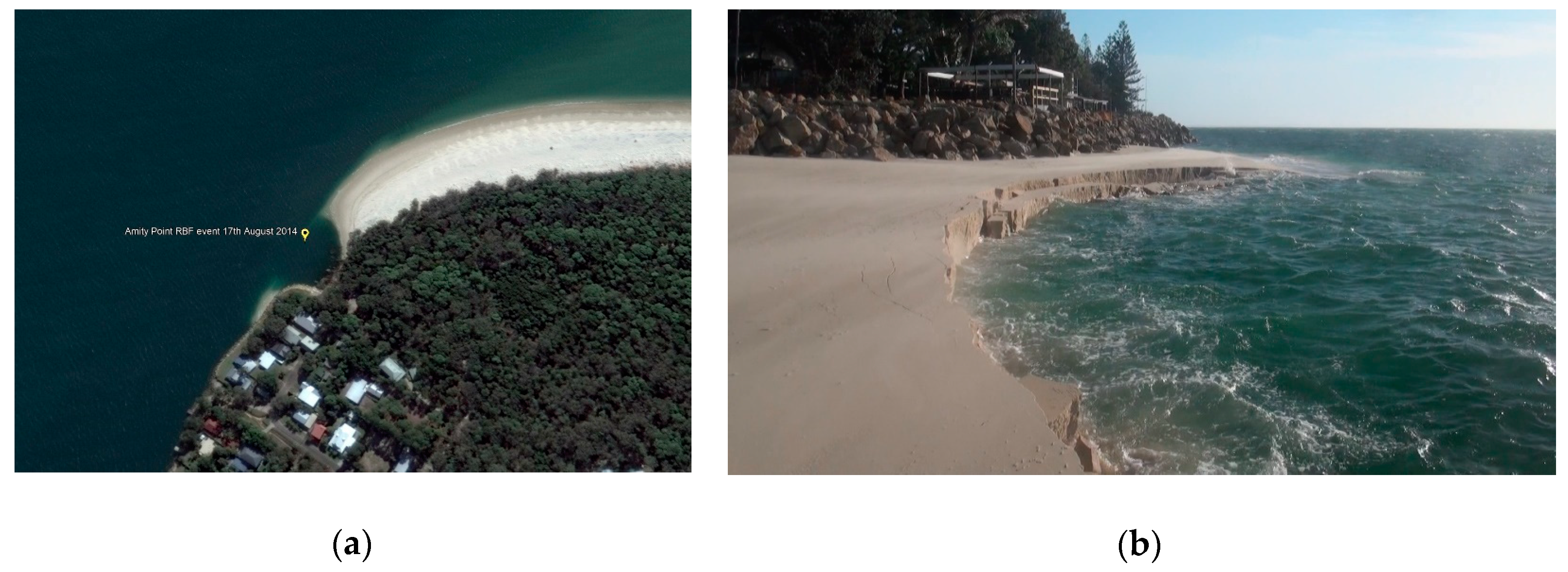
Prior to 2014, the geo-mechanical mechanisms driving these erosion events remained unclear to local coastal scientists and engineers. They were usually misdiagnosed as shear failures of an over-steep channel margin. Following a recent concerted awareness campaign, most local professionals now recognize these events as ‘retrogressive breach failures’ (RBF events) after Beinssen [1] (Figure 8b). Several ‘hotspots’ can be identified, including Amity Point on the NW point of North Stradbroke Island, which is a low spit of Holocene deposited fine silica sand (Figure 8a). A deep (22m) tidal channel runs close to the shoreline. Frequent RBF events have been occurring here for over a century and often collapse the beach and sometimes penetrate into vegetation further inland (Figure 9).
Local historian Thomas Welsby wrote in 1913 [43] of his observations made many years earlier: ‘I have known large slips at Amity carry away tons of sand and many a tea-tree familiar to my boating companions has toppled and fallen into the waters of the Bay’.
Events still occur frequently here. One specific site was monitored for 26 months during which 52 events were recorded [2], so on average an event reached the shoreline every two weeks. After each event, a crater is left which is subsequently filled with sand transported to the site in the littoral drift to set conditions for the next event. Since the water is usually very clear at Amity Point, the shear failure of wedges of sand under the water table has also been clearly observed in natural RBF events as they reach the shoreline. This is known as ‘dual mode failure’ [44,45].
The trigger that starts these events is not known and will be the subject of further research in Australia. One event in January 2011 coincided exactly with the arrival of a silt laden flood plume from the Brisbane River which substantially increased local tidal velocity and so suggests that the initial breach was formed on this occasion by current scour. Another event coincided with the draining of a lake after heavy rain indicating that submarine groundwater discharge may have been the trigger.
3.2. Plaat van Walsoorden Flood Control Test, Netherlands
In 2014, as a part of the flood risk assessment due to dike failure in the Netherlands, the development of a flow slide was extensively monitored in a field experiment, which tracked the progress of an artificially triggered breach in a sand shoal in the Western Scheldt [46,47]. At this site a large natural flow slide and shoal margin collapse occurred on 22 July 2014 [48,49,50], only weeks before the field test was scheduled. This demonstrated the vulnerability of the site to flow slides. Consequently, the test site was relocated a few hundred meters to the east, where conditions were almost identical.
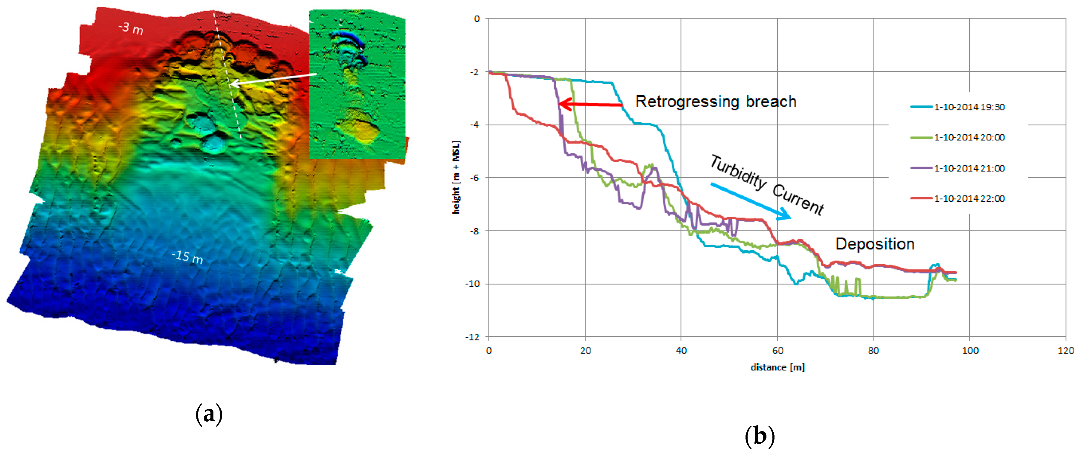
Extensive pre- and post-geotechnical and bathymetric investigations were performed. Breach failures were initiated by dredging and multiple flow slides with over 6-meter-high breaches and associated density currents were detected for a few hours on high-resolution multibeam echo sound images (Figure 10). On this occasion, retrogression terminated near the low tide mark and the volume of displaced sand remained small. The test conclusively demonstrated that these flow slides were characterized by slow retrogressive breaching (indicating that the sand exhibited dilatant behavior despite its young marine origin) and that the sand was conveyed away from the breach for some distance. However, why these breaches did not retrogress further and grow as large as the earlier natural event remains unclear.
3.3. Ameland Southwest Beach Collapses, Netherlands
The Wadden Sea in the north of the Netherlands is characterized by tidal inlets between barrier islands. Here, the Borndiep tidal inlet approaches the southwest coast of Ameland island and consists of sand and steep, firm clay layers to a depth of 20m. The coast is defended by revetments and groynes. At one specific site (Figure 11), adjacent to a groyne, the revetment turned out to be damaged and here periodical beach collapse events (‘strandvallen’ in Dutch) have occurred [51].
In 1979, a tragic accident took place at this site when a rescue boat was launched for an emergency and all 10 horses pulling the trailer over the beach to the seafront suddenly fell into deep water and drowned, probably due to an RBF event. In 2017 and 2019, beach collapse events again occurred at this site and were captured on video for the first time in the Netherlands. This footage displays the slow retrogressive nature of the collapses and the steep wall with sliding blocks, typical for RBF events (Table 1).
3.4. Coastal Erosion and Associated RBF Events at Cap Ferret, France
The Bassin d’Arcachon at the Atlantic coast of France is a triangle shaped lagoon, about 174 km² in area. This area is completely submerged during high tides and about 65% emerges at lowest tides only. Inside the bay, deeper channels convey high tide water towards an entrance, which is about 4km wide and about 10 m deep, oriented north south. Strong tidal currents flow through the entrance. Cap Ferret is a natural sand spit dividing the outlet of the Bassin d’Arcachon from the Atlantic Ocean. It consists of fine silica sand (150–200 µm) and its surface is largely covered by woods, municipal facilities and residential houses [52].
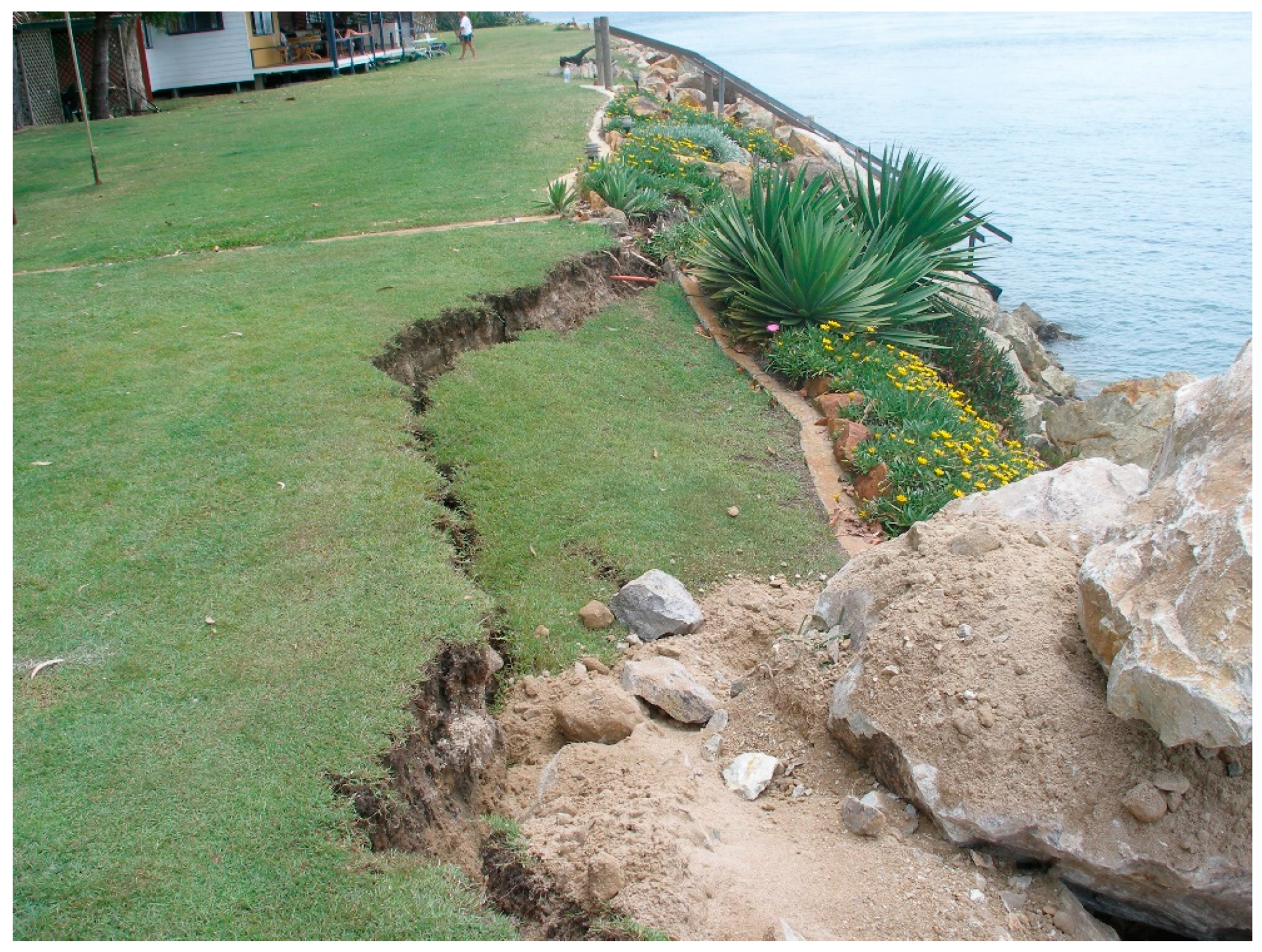
The highest flow velocities are observed along the south-eastern side of Cap Ferret. This shoreline has faced recurrent and hazardous slumping associated with ongoing coastal erosion. The coast on the inner part of the lagoon is partly protected from oceanic swell but several locations along the spit have been damaged in the past by sudden beach or rip-rap collapse events. In particular, the southernmost beach is subject to beach collapses. Figure 12 shows a recent example of an active medium-sized event (about 10 m in diameter). The coastal morphodynamical process is characterized by a cycle of RBF events followed by rapid infilling of sand carried to the site by the littoral drift. The site is analogous to Amity Point and Ameland described above in its geographical setting, frequency, and size of RBF events and the presence of a nearby riprap protection construction.
Considering the potential danger of a beach collapse to the public, a program to monitor the beach using time lapse photography was carried out over a 17-month period in 2015 and 2016. Many RBF events were recorded, and the beach dynamics of this site was described. The diameters of RBF scars range from 1–5 m to about 25–30 m. It was found that the events that emerged above water are part of a larger number of partly or entirely subaqueous events.
Time intervals between events also cover a large range of values, from one day to several weeks. Beach recovery can be very rapid here, nourished with sand carried in the littoral drift. It generally comes along with a redistribution of sand on a large coastal area surrounding the scar and induces a significant modification of the beach shape, showing that a larger area is influenced by morphodynamical processes here than just within the RBF scar itself.
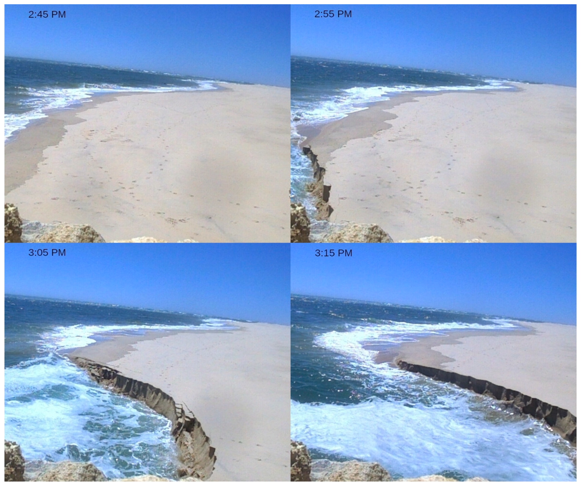
Figure 13 shows another event at Cap Ferret, seen over a timestamped sequence of static views. It shows a regression speed of about 10 m over half an hour or about 5 mm/s.
3.5. Internet Video Search Results
Very few coastal experts have actually witnessed and reported an active flow slide process. Van den Berg [4], for the first time, described a typical RBF event with sequential photographs that took place on a sandy shoal in the Dutch Wadden Sea in 1983.
More recently new direct observational field evidence including videos of RBF events in beaches or banks has become available. Table 1 gives an overview with internet links. Today with cell phone cameras and social media, rare events can be captured and shared, although observers are usually not aware of the geo-mechanical processes they are witnessing. Video evidence is particularly useful since it provides an understanding of time scales. Using key words such as ‘sinkhole’, ‘beach liquefaction’, ‘beach collapse’, ‘sand collapse’, ‘disappearing beach’, or simply ‘beach erosion’, descriptions and video footage can be found on the internet, usually with related information such as location, timing, and local engineering interpretations. Searching in other languages also often reveals events which can be interpreted as RBF events; in Dutch ‘strandval’, in French ‘effondrement de plage’. and in German ‘Einsturz’ or ’Uferrutschung’.
The first video of a large beach collapse that we now identify as an RBF event, was recorded with a cell phone at Inskip Point, Australia in 2011 and posted on the internet (Figure 2). This event was also reported by the TEN NEWS, Australia network. Large events at this location again took place and were recorded and posted in 2015 (with some damage to a camping area) and most recently 2018 (Figure 1). We found further examples of internet published footage of active events. In the USA, an event at Fort Popham, MN was recorded in 2011 and another at North Wildwood, NJ, in 2012 where on a previous occasion, reported by NBC10 Philadelphia, three bathers fell into the water, were dragged into the tidal current and drowned. Another event occurred in the Philippines at Candelaria, Zambales in 2013, reported by ANC news. Videos clearly reveal the slow retrogressive nature of the above RBF events, the sliding of blocks of sand and the steep scar. Typical RBF ‘footprints’ often can be identified on Google Earth satellite images (Figure 8a).
4. The Modern Understanding of Retrogressive Breach Failures (RBF)
4.1. The Breaching Mechanism
Retrogressive breaching requires sand to be relatively tightly packed, so that it will dilate when subjected to shear, as discovered in Dutch dredging research [25,26,27,28]. The ‘shear dilatancy effect’ requires sand grains to lever themselves apart under shear, thus increasing the void ratio and causing a lowering of pore water pressure relative to ambient pressure. It is this ‘underpressure’ that causes suction and stiffens the deposit (strain hardening), allowing a steep, almost vertical sand slope to temporarily exist. Figure 14 (lower layer) shows a breach face in a small-scale suction test [46]. Shear dilatancy cannot occur in loosely packed sand; instead the sand grains slide along the natural friction angle (Figure 14, upper layer). Retrogressing sand walls were also observed in the field during suction dredging and were named ‘Aktive Bresche’ [53], active banks [54], or breaches [26,55]. In sand mining pits the process can unintentionally result in bank collapses (RBF events).
Van den Berg [4] introduced breaching of sand as a natural slope failure mechanism in deep sea sediments, generating supercritical turbidity currents in submarine canyons, to explain fine-layered geological deposits (turbidites). Van Rhee and Weij [56,57] suggested ‘unstable breaching’ to be distinguished from stable breaching as is used in dredging practice.
Although pore water under-pressures generated by the dilatant shearing of sand stabilizes the sand wall, it may still fail by shearing from time to time. Wedges of sand shear off the breach and fall, mixing with water and boosting the density current. A new breach surface is then exposed which again sheds sand grains individually so that the mechanism switches back and forth between the two failure modes. Van Rhee and Bezuijen [55] reported this from flume tank tests and You et al [44,45] applied the name ‘dual mode failure’. The initiation and development of a full RBF event, however, has never been observed in flume tests, probably because available experimental facilities are too small.
4.2. The Density Current
Another prerequisite for sustained active breaching is that the sand raining or sliding from the sand wall is transported away from its base. If the breach is sufficiently high and the sand sufficiently fine, the suspended sand can gain enough momentum to initiate a turbulent density current. With supercritical flow conditions, enough sand will be removed from the base of the wall to permit breaching to continue.
As the density current flows downslope, it can generate enough momentum to erode the seafloor at the base of the breach and further downslope, entraining more sand in suspended load and increasing its density. This self-accelerating nature (sometimes called ignitive growth) of turbidity currents, as introduced by Parker et al. [58], depends on slope geometry and seabed sediment properties and has been modelled in various ways [59,60]. Retrogressive breaching can maintain sustained turbidity currents for hours in a quasi-steady mode, flushing sediment filled submarine canyons on a large scale [59,61,62]. As the density current encounters more gentle slopes, it will gradually lose momentum, slow and dissipate so that sand deposition prevails.
4.3. Anatomy of an RBF Event
In common with all landslides, RBF events are powered by gravitational potential energy. However, the mechanism is more complex than most other types of (submarine) landslides. RBF events require two elements working in tandem:
- (1)
- A geotechnical element: The ‘shear dilatancy’ or ‘breaching effect’ taking place within the sand skeleton itself, causing suction, which stabilizes the retrogressing sand wall, at slopes much steeper than the natural angle of internal friction. This requires the sand to be sufficiently densely packed (dilatant) and water saturated. The breach sheds a constant supply of ‘raining’ sand particles into the water that produces a dense mixture of sand and water.
- (2)
- A hydrodynamic element: This is characterized by the generation of a turbulent density current mixing and carrying suspended sand grains downslope and is governed by slope geometry and sand characteristics. The sand must be fine grained (low fall velocity) so that the density current can carry the grains some distance away before they again settle out of suspension. The breach must be high enough to provide enough sand and energy for turbulent mixing of the sand grains with ambient water to generate a homogeneous, denser than water suspension.
Figure 15 gives a schematic diagram of an RBF event.
The following processes and stages of an RBF event can be distinguished:
Preconditions: Fine-grained dilatant and water-saturated sand on a sufficiently steep and high subaqueous shoreface or channel slope. The ‘rule of thumb’ to assess flow slide vulnerability is a gradient of 18° (1:3) or more over a height of 5 m or more and a total slope height over 10 m [6]. The sand needs to be sufficiently fine grained (about 100–200 µm), freshly deposited (in general young uncemented Holocene marine sands), and not containing too much clay which could make the sediments more cohesive and less prone to breaching. More advanced methods to assess flow slide occurrence and flood risk have been developed in the Netherlands [21,31].
Triggering: The start of a natural event has never been directly observed so it is not known how small the initial breach is or how it is formed. Possible mechanisms are a small shear failure, liquefaction, or fluidization caused by submarine groundwater discharge, in turn caused by an exceptionally low tide or after high rainfall, conditions that are often mentioned in the literature. However, it can be assumed that if unstable preconditions exist, some form of triggering mechanism is likely to ultimately occur to set off an RBF event.
Breaching: Once started, a breach tracks autonomously upslope, powered by gravitational potential energy only. The only condition required for the breaching process to continue is that enough sand is conveyed away from the base of the sand wall so that its height is maintained or can grow.
The density current: If the sand wall is high enough, the sand grains being shed from the breach will mix with ambient water to generate a homogeneous denser than water, turbulent suspension that flows rapidly downslope as a density current and behaves like a deep-sea turbidity current. If the underwater slope is high and steep enough, the density current will entrain seabed sand and increase its density, resulting in a self-accelerating avalanche-like flow. This will lead to further slope degradation and increase the size of the event.
Reaching the shoreline (beach, bank, or defense structure): Events always track upslope along the maximum seafloor gradient and if breaching does not terminate underwater (for example by a change in the geology or sand properties or slope causing deposition of sand at the base of the breach etc.), the sand wall can reach the shoreline and continue into the beach or shore, where it can be observed and videoed. Moist unsaturated sand (where grains are held together by surface tension resulting in cohesive behavior) is undermined and topples off in blocks.
Termination: RBF events terminate naturally when sand settles at the base of the breach, reducing the sand wall height to the point where breaching can no longer shed enough sand to sustain the density current. The distance which events can penetrate landward is limited because whilst the runout angle is usually small (about 3–4° or 1:15 to 20, [6]) the breach height is limited at the top by the level of the water table. Therefore, as an event penetrates landward, the height of the breach progressively reduces. Events terminate abruptly as the almost vertical under water breach reduces its steepness and porewater under-pressures decrease until the slope reaches the natural angle of internal friction of the sand.
Detailed numerical modelling of the breaching process and the successive turbidity current, resulting in the assessment of the potential damage parameters of RBF events (such as post-event retrogression length, duration, run-out angle, and displaced volume of sediment), has not yet been successful, despite decades of research effort. It requires an accurate knowledge of the geotechnical properties of the sand bed (such as dilatancy and compaction), as well as the hydraulic properties of the sand-carrying density flow (such as erosion, deposition, and turbulent mixing). Progress is being made with computational fluid dynamics models [57] and material point methods [63,64]. The best approach may prove to be a hybrid model, combining the strength of both types of schematizations.
5. Modern Flow Slide Protection and Coastal Defense Strategies
Since a better understanding of the RBF mechanism is now available, new opportunities for prediction, prevention, and mitigation measures and even completely new and innovative solutions for coastal defense are possible. Most experience in defense against coastal flow slides still resides in the Netherlands. Here, coastal construction work to protect newly reclaimed polders in Zeeland, started in the late 18th century. Early engineering works often remained ineffective since only ‘defended points’ or groynes were built at that time. Between these points the tidal channel kept approaching the shoreline, so the embankments remained vulnerable to sequential RBF events. Recession often continued until the embankment finally collapsed (Figure 4 and Figure 6). The oldest and largest sea defense construction in the Netherlands, the Helderse Zeewering (Den Helder seawall), originally built in 1750, finally stopped the ongoing loss of land in the North of Holland and still survives today due to continuous monitoring and maintenance by Dutch authorities [65].
During the Delta works program, started after the 1953 floods and completed in 1987, closure dams and storm surge barriers were built and sea dikes were extensively reinforced. Since then no further damage by flow slides has occurred. Note that in Figure 3, a flow slide is detected that penetrated into the unprotected channel slope and partly under the scour protection (black lines) of the Eastern Scheldt Storm Surge Barrier. This event remained completely submerged and only minimal damage occurred [8]. Here, protection consists of connected stone mattresses, which can be undermined by breaching. Loose stone protection may have quenched this event earlier. The stability of the barrier itself was not affected and additional maintenance measures have since been taken.
It can now be understood why slope protection using rock fill and rip-rap cover, such as those applied over many years in the Netherlands, actually works. It also explains how the collapsing rock wall at Amity Point acts to smother RBF events.
To validate and demonstrate the role of breaching, some simple tests have been conducted in a small-scale flume with a 1:2 (26°) protected slope in fine sand (see Figure 16). The breaching process was maintained by constant suction, in the same way as shown in Figure 14, simulating constant removal of sand by tidal currents. A full RBF event will not take place in a small-scale experiment like this, since a sufficiently strong density current cannot develop. Two types of protection that are generally applied, were tested:
- (a)
- a filter-construction of fine and coarse gravel installed directly on the sand. In this test, the retrogression of the breach was immediately smothered by falling loose rocks covering the breach.
- (b)
- the same protection layer but laid on top of a permeable geotextile membrane. In this test, undermining by breaching continued steadily under the membrane until, after some hours, the complete slope had been degraded, and the natural angle of repose reached.
Today, for protection of the mildly sloping coastal zones along the North Sea where erosion only occurs during storm events, sand nourishment is generally used as the best erosion prevention strategy. Vegetation can also protect the berms of sea dikes from wave attack. However, along the deep tidal channels in Zeeland and the Wadden Sea, where tidal channels run close to the embankment, currents are often too strong for these strategies.
Risk for protected embankments along tidal channels and rivers still exists in the case of scouring of the channel bed near the toe of the underwater slope. Generally, the toe is protected also with rock armor or mattresses but where ongoing scour exists, a breach can develop that retrogresses and undermines the complete revetment [66]. If consisting of a sufficiently thick layer of loose rock, the breach will be quickly covered and smothered, preventing further retrogression, as shown in flume tests (Figure 16).
Recurrent RBF events over many years at Amity Point in Australia have caused significant coastal recession into both publicly and privately-owned land in a small coastal village [1,2]. Several erosion defense strategies have been trialed ranging from wooden and rock groins and placement of car bodies. All proved to be ineffective until finally a continuous rock wall was progressively built, funded by both private landowners and Government. This has proven to be successful in stopping further loss of land. Deep RBF events sometimes still penetrate under this barrier, but this causes rocks to slump into the breach, quenching further retrogression. Where slumping has occurred, as in Figure 17, the sea wall was repaired by adding rocks from above, so the wall foundation moves deeper after each event. In this way, the structure has become more stable over time. The protective riprap wall is now called a ‘flow slide barrier’ and its effectiveness is acknowledged by local coastal engineers. A ‘Shoreline Erosion Management Plan’ has recently been adopted, which formalizes this understanding [67].
Beinssen and Neil [2] describe how a collapsing riprap works to quench an active event. If an event encounters a rock wall defense and the base of the breach is higher than the rock wall foundations, the event terminates because it runs out of sand (Figure 8). If the base of the breach is lower than the rock wall foundations, the breach will undermine the rocks and the wall will slump or collapse (Figure 17).
At Cap Ferret in France, local authorities are concerned about the hazardous character and frequency of RBF events and consequently have restricted access to unstable beach areas for public safety. Though RBF events occur most frequently on the beach immediately adjacent to the riprap protection wall, no causal link has been established between the seawall and beach collapses. In the past, seawall extensions moved the most frequent events southward, but recently, several massive collapses of riprap material have also occurred along the protected shoreline. Falling rocks appear to be the most superficial ones and the core of the seawall remains stable.
6. Conclusions
Coastal flow slides or RBF events are slope failures which occur naturally in subaqueous slopes of fine, water saturated sands in the coastal shoreface. Events go mostly unnoticed but sometimes they emerge onto beaches, shoals, tidal flats or river banks. Events are powered by gravity and not by the kinetic energy of storms, waves or currents. The phenomenon is generally not well recognized or understood by coastal engineers although flow slides can threaten coastal infrastructure and embankments and cause significant coastal recession and flood risk. We have documented the history of coastal flow slides in the Netherlands and the immense impact on land loss, finally overcome with the completion of the Delta Works in 1987.
Ever since the first eyewitness reports of these events were published in the Netherlands over a century ago, attempts have been made to understand the geo-mechanical mechanism. For many years it was thought that the failure mechanism was liquefaction induced sliding, as proposed by Terzaghi, the ‘father of modern geotechnical engineering’ in 1925. We have established that early events, observed during the active phase, were characterized by a slow, steadily retrogressing sand wall as they arrived at the shoreline, going on for many hours to a day as described in now forgotten eyewitness reports, and shown that this is not consistent with Terzaghi’s analysis.
Dredging research in the Netherlands in the 1970s revealed slow retrogressive breaching in dilative sands as an alternative explanation for the flow slide failure mechanism. Breaching occurs when medium to tightly packed sand is subjected to shear and consequently dilates internally (shear dilatancy effect) so that a temporary ‘under-pressure’ or suction occurs in the pore water. The sand wall or breach is temporally stabilized by this internal suction (strain hardening) which reduces as water flows into the deposit. The breach sheds sand grains, which generate an associated density current. The only requirement for breaching to continue is that enough sand is conveyed away from the base of the breach by the density current so that its height is maintained or increased. In order to maintain a sustained breaching event, the sand must be fine enough to be entrained and conveyed away from the breach before again settling out of suspension.
Recently, further evidence on the flow slide mechanism has become available in the form of video footage posted on the internet of active events in Australia, France, the Netherlands and in coastal areas elsewhere in the world. This footage clearly confirms the slow retrogressive nature of the events and the near vertical breach. These observations exclude liquefaction failure as the mechanism and justify the term ‘retrogressive breach failure’ (RBF event).
Flow slides present difficult problems to researchers; their timing and location can be predicted only in terms of probability and they occur largely underwater where they are hidden from view. We have described how flow slides can pose risks to infrastructure and lead to undermining of shore and bank defenses, leading in turn to loss of land and flooding. By understanding the mechanism, better defense strategies can be envisaged. Shore and levee protection using rock protection and riprap can now be understood, since rocks slump and smother the breach, disrupting the progress of events. This has been observed in the field in Australia and France and confirmed in recent flume tests.
We explained that the lack of a consistent name for these events has confused thinking over many years. We propose the name ‘retrogressive breach failure’ (RBF event) because it accurately describes the process. In writing this paper, we hope that the coastal science and engineering communities will better recognize and understand these intriguing natural events.
Author Contributions
Idea, research, and manuscript by D.R.M., Section 3.1, Section 4.3, and part of Section 5 and general review by K.B., Section 3.4 and part of Section 5 by Y.N.
Funding
This research received no external funding.
Acknowledgments
We like to thank Ad van der Spek and Ad van Os for advice.
Conflicts of Interest
The authors declare no conflict of interest.
References
- Beinssen, K.; Neil, D.T.; Mastbergen, D.R. Field Observations of Retrogressive Breach Failures at two Tidal Inlets in Queensland, Australia. Aust. Geomech. 2014, 49, 55–63. [Google Scholar]
- Beinssen, K.; Neil, D.T. Retrogressive Breach Failure Events at Amity Point, Australia and their Interaction with Built Defences. In Proceedings of the 25th International Ocean and Polar Engineering Conference, Kona, HI, USA, 21–26 June 2015; pp. 1325–1330. [Google Scholar]
- Koppejan, A.W.; Van Wamelen, B.M.; Weinberg, L.J.H. Coastal Flow Slides in the Dutch Province of Zeeland. In Proceedings of the 2nd International Conference on Soil Mechanics and Foundation Engineering, Rotterdam, The Netherlands, 21–30 June 1948; Volume 13, pp. 89–96. [Google Scholar]
- Van den Berg, J.H.; Van Gelder, A.; Mastbergen, D.R. The importance of breaching as a mechanism of subaqueous slope failure in fine sand. Sedimentology 2002, 49, 81–95. [Google Scholar]
- Silvis, F.; De Groot, M. Flow slides in the Netherlands: Experience and engineering practice. Can. Geotech. J. 1995, 32, 1086–1092. [Google Scholar] [CrossRef]
- Wilderom, M.H.; Bakker, W.T. Resultaten van Het Vooroeveronderzoek Langs de Zeeuwse Stromen; Nota 75.2; Rijkswaterstaat: Vlissingen, The Netherlands, 1979. [Google Scholar]
- De Groot, M.B.; Mastbergen, D.R. Scour hole slope instability in sandy soil. In Proceedings of the 3rd International Conference on Scour and Erosion, Amsterdam, The Netherlands, 1–3 November 2006; CURNET: Gouda, The Netherlands. [Google Scholar]
- Stoutjesdijk, T.; Mastbergen, D.; De Groot, M. Stormvloedkering Oosterschelde: Ontwikkeling Ontgrondingskuilen en Stabiliteit Bodembescherming; Deelrapportage Hellinginstabiliteit; Deltares: Delft, The Netherlands, 2012. [Google Scholar]
- Van Dijk, W.M.; Mastbergen, D.R.; Van den Ham, G.A.; Leuven, J.R.F.W.; Kleinhans, M.G. Location and probability of shoal margin collapses in a sandy estuary. Earth Surf. Process. Landf. 2018, 43, 2342–2357. [Google Scholar] [CrossRef] [Green Version]
- De Bruin, M.P.; Wilderom, M.H. Tussen Afsluitdammen en Deltadijken; Deel 1; Noord-Beveland: Middelburg, The Netherlands, 1961. [Google Scholar]
- Lambrechtsen, C.L.M. Afschuiving aan Den Oever van den Calamiteusen Vlietepolder op 28 Oct. 1886. Verhandelingen 1888–1889, Tijdschr. Kon. Inst. v. Ing., 1888, 51–59, Platen 8, 9 en 10, Van Langenhuysen, ‘s-Gravenhage, The Netherlands.
- Neyt, P.J. Oeverafschuiving aan den Vlietepolder, Mededeelingen nopens den Oeverafschuiving den 10den Maart 1864 aan den Vlietepolder Ontstaan, Verhandelingen 1865–1866 Kon. Inst. v. Ing., 1865, 4–10, Plaat 1–3, The Hague, The Netherlands. Available online: http://lib.tudelft.nl/books/?bookname=Verhandelingen%201865-1866%20deel%202&page=1 (accessed on 16 October 2019).
- Van Rummelen, F.F.F.E. Dike- and Coast-Falls in the Province of Zeeland (South Western Netherlands). Geol. Mijnb. 1960, 39, 692–700. [Google Scholar]
- Müller, F. Das Wasserwesen der Niederländischen Provinz Zeeland; with Atlas Containing 10 Tafeln (Maps) with Detailed Illustrations, Berlin, W. Ernst Verlag, 1898; Reprint; Kessinger Legacy Reprints: Whitefish, MT, USA, 2010. [Google Scholar]
- Terzaghi, K. Erdbaumechanik auf bodenphysikalischer Grundlage; Franz Deuticke: Leipzig, Germany, 1925. [Google Scholar]
- Gudehus, G.; Keßler, J.; Lucke, B. Setzungsfließen. Geotechnik 2015, 38, 255–266. [Google Scholar] [CrossRef]
- Terzaghi, K.; Peck, R.B. Soil Mechanics in Engineering Practice; Wiley & Sons: New York, NY, USA, 1948; Second edition, Wiley, 1967, Third edition, Wiley, 1996. [Google Scholar]
- Keverling Buisman, A.S. Grondmechanica; Waltman: Delft, The Netherlands, 1940; Heruitgave: Balkema: Rotterdam, The Netherlands, 1996. [Google Scholar]
- Barentsen, P. Oevervallen, Zettingsvloeiingen of Kwelafschuivingen? In Orgaan van de Technisch Ambtenaren van den Rijkswaterstaat; OTAR: Dordrecht, The Netherlands, 1943; Volume 27, pp. 131–139. [Google Scholar]
- Stoutjesdijk, T.P.; De Groot, M.B.; Lindenberg, J. Engineering Approach to Coastal Flow Slides. In Proceedings of the 24th International Conference on Coastal Engineering, Kobe, Japan, 23–28 October 1994; pp. 3350–3359. [Google Scholar]
- De Groot, M.; Adel, H.D.; Stoutjesdijk, T.; Van Westenbrugge, C. Risk of dike failure due to flow slides. Coast. Eng. 1995, 26, 241–249. [Google Scholar] [CrossRef]
- De Groot, M.B.; Lindenberg, J.; Mastbergen, D.R.; Van den Ham, G. Liquefaction flow slides in large flumes. Int. J. Phys. Model. Geotech. 2019, 19, 37–53. [Google Scholar] [CrossRef]
- De Jager, R.R.; Maghsoudloo, A.; Askarinejad, A.; Molenkamp, F. Preliminary Results of Instrumented Laboratory Flow Slides. Procedia Eng. 2017, 175, 212–219. [Google Scholar] [CrossRef]
- De Jager, R.R. Assessing Liquefaction Flow Slides. Ph.D. Thesis, Delft University of Technology, Delft, The Netherlands, 2018. [Google Scholar] [CrossRef]
- Breusers, H.N.C. Suction of sand. Bull. Int. Assoc. Eng. Geol. Kref. 1974, 10, 65–66. [Google Scholar] [CrossRef]
- Van Kesteren, W.G.M.; Steeghs, H.J.M.G.; Mastbergen, D.R. Pore water behavior in dredging processes. In Proceedings World Dredging Conference XIII; Van Dam, V.L., Ed.; Universal Publishing Corporation: Bombay, India, 1992; pp. 598–615. [Google Scholar]
- Meijer, K.L.; Van Os, A.G. Pore Pressures Near Moving Underwater Slope. ASCE J. Geotech. Div. 1976, 102, 361–372. [Google Scholar]
- Van Os, A.G. Behaviour of soil when excavated under water. In Proceedings of the International Course on Modern Dredging, D.2, Delft, The Netherlands, 5–10 June 1977. Foundation Post Graduate Courses in Civil Engineering. [Google Scholar]
- Boehmer, J.W.; Borst, W.G.; Bras, A.; Van Raalte, G.H. Slope stability and slope production tests. A new tool in harbour design and dredging practice. In Proceedings of the World Dredging Congress X, BHRA, Singapore, 19–22 April 1983; pp. 283–308. [Google Scholar]
- De Groot, M.B.; Van der Ruyt, M.; Mastbergen, D.R.; Van den Ham, G.A. Bresvloeiing in Zand. Geotechniek 2009, 34–39. [Google Scholar]
- Van den Ham, G.A.; De Groot, M.B.; Mastbergen, D.R. A semi-empirical method to assess flow slide probability. In Submarine Mass Movements and Their Consequences; Advances in Natural and Technological Hazards Research; Krastel, S., Behrmann, J.-H., Volker, D., Stipp, M., Berndt, C., Urgeles, R., Chaytor, J., Huhn, K., Strasser, M., Harbitz, C.B., Eds.; Springer International: Cham, Switzerland, 2014; Volume 37, pp. 213–223. [Google Scholar]
- McKenna, G.T.; Luternauer, J.L.; Kostaschuk, R.A. Large-scale mass-wasting events on the Fraser River delta front near Sand Heads, British Columbia. Can. Geotech. J. 1992, 29, 151–156. [Google Scholar] [CrossRef]
- Ishihara, K. Flow Slides of Underwater Sand Deposits in Jamuna River Bed. In Geotechnical Engineering for Disaster Mitigation and Rehabilitation; Liu, H., Deng, A., Chu, J., Eds.; Springer: Berlin/Heidelberg, Germany, 2008. [Google Scholar]
- Sladen, J.A.; D’Hollander, R.D.; Krahn, J.; Mitchell, D.E. Back analysis of the Nerlerk berm liquefaction slides. Can. Geotech. J. 1985, 22, 579–588. [Google Scholar] [CrossRef]
- De Groot, M.B.; Heezen, F.T.; Mastbergen, D.R.; Stefess, H. Slopes and densities of hydraulically placed sands. In Proceedings of the Geot. Div. ASCE Spec. Conf. on Hydraulic Fill structures, Fort Collins, CO, USA, 15–18 August.
- Wanatowski, D.; Chu, J.; Lo Robert, S.C. Types of flow slide failures and possible failure mechanisms. In Geotechnical Engineering for Disaster Mitigation and Rehabilitation; Liu, H., Deng, A., Chu, J., Eds.; Springer: Berlin/Heidelberg, Germany, 2008. [Google Scholar]
- Stouffer, J.D. Verification of Empirical Method of Determining Slope Stability, 1956 Data, Potamology Investigations; Report No. 12-7; US Army Waterways Experiment Station: Vicksburg, MS, USA, 1957. [Google Scholar]
- Torrey, V.H., III; Dunbar, J.B.; Peterson, R.W. Retrogressive Failures in Sand Deposits of the Mississippi River; Report 1: Field Investigations, Laboratory Studies, and Analysis of Hypothesized Failure Mechanism. Report 2: Empirical Evidence in Support of the Hypothesized Failure Mechanism and Development of Levee Safety Monitoring System; Technical Report GL-88-9; Waterways Experiment Station Corps of Engineers: Vicksburg, MS, USA, 1988. [Google Scholar]
- Dunbar, J.B.; Torrey, V.H.; Wakeley, L.D. A Case History of Embankment Failure: Geological and Geotechnical Aspects of the Celotex Levee Failure, New Orleans, Louisiana; Technical Report GL-99-11; Waterways Experiment Station, US Corps of Engineers: Vicksburg, MS, USA, 1999. [Google Scholar]
- Padfield, C.J. The Stability of River Banks and Flood Embankments, a Centrifugal Model Study of the Influence of the Interaction of Two Deforming Layers in the Analysis of Two River Bank Stability Problems. Ph.D. Thesis, Cambridge University, Cambridge, UK, 1978. [Google Scholar]
- Reuss, R.F. Bank Cavings Investigations Free Nigger Point and Point Menoir Mississippi River, Potamology Investigations; Report, No.15-1; US Army Waterways Experiment Station: Vicksburg, MS, USA, 1952. [Google Scholar]
- Shipway, I. Risks Associated with Nearshore Instability at Inskip Point; EDG Consulting: Brisbane, Australia, 2015. [Google Scholar]
- Thomson, A.K. (Ed.) The Collected Works of Thomas Welsby; Jacaranda Press Pty. Ltd.: Brisbane, Australia, 1967. [Google Scholar]
- You, Y.; Flemings, P.; Mohrig, D. Dynamics of dilative slope failure. Geology 2012, 40, 663–666. [Google Scholar] [CrossRef] [Green Version]
- You, Y.; Flemings, P.; Mohrig, D. Mechanics of dual-mode dilative failure in subaqueous sediment deposits. Earth Planet. Sci. Lett. 2014, 397, 10–18. [Google Scholar] [CrossRef]
- Mastbergen, D.; Van den Ham, G.; Cartigny, M.; Koelewijn, A.; De Kleine, M.; Clare, M.; Hizzett, J.; Azpiroz, M.; Vellinga, A. Multiple flow slide experiment in the Westerschelde Estuary, The Netherlands. In Submarine Mass Movements and Their Consequences. Adv. in Nat. and Techn. Hazards Res.; Lamarche, G., Mountjoy, J., Bull, S., Eds.; Springer: Cham, Switzerland, 2016; Volume 41, pp. 241–252. [Google Scholar] [CrossRef]
- Van den Ham, G.A.; Mastbergen, D.R.; Koelewijn, A.R.; Ter Brake, C.K.E.; Zomer, W.S. Eindrapport Validatie-Experiment Zettingsvloeiing, Meten aan Zettingsvloeiing, Amersfoort: STOWA- Flood Control IJkdijk. 2015. Available online: https://www.stowa.nl/sites/default/files/assets/PUBLICATIES/Publicaties%202015/STOWA%202015-08.pdf (accessed on 16 October 2019).
- Van Schaick, S.J. Morphological Development after the July 2014 Flow Slide on the Tidal Flat of Walsoorden. Master’s Thesis, Delft University of Technology, Delft, The Netherlands, 2015. Available online: http://resolver.tudelft.nl/uuid:1d2fee04-7ec1-4132-b894-9b77b7e6a705 (accessed on 16 October 2019).
- Berg, J.V.D.; Martinius, A.; Houthuys, R. Breaching-related turbidites in fluvial and estuarine channels: Examples from outcrop and core and implications to reservoir models. Mar. Pet. Geol. 2017, 82, 178–205. [Google Scholar] [CrossRef]
- Mastbergen, D.R.; Van Schaick, S.J.; Van der Werf, J.J.; Schrijvershof, R.A. Flow Slide in the Tidal Flat of Walsoorden, Western Scheldt. In Poster, NCK Days; Netherlands Centre for Coastal Research: Delft, The Netherlands, 2016; Available online: https://www.nck-web.org/content/documents/book_of_abstracts_2016.pdf (accessed on 16 October 2019).
- Vermaas, T.; Mastbergen, D.; Van Dijk, T.; De Kleine, M.; Mesdag, C.; Hoogland, R.; Gaida, T. Geology and Morphology at Ameland South West. In Poster, NCK Days; Netherlands Centre for Coastal Research: Delft, The Netherlands, 2018; Available online: https://www.nck-web.org/content/documents/BoA_2018-compressed.pdf (accessed on 16 October 2019).
- Nédélec, Y.; Revel, J. Phénomènes D’érosion Côtière: Instabilité et Consolidation de Talus Littoraux Sur la Façade est du cap Ferret (Gironde); Rencontres Universitaires de Génie Civil: Bayonne, France, 2015; Available online: https://hal.archives-ouvertes.fr/hal-01167635/document (accessed on 16 October 2019).
- De Koning, J. Neue Erkenntnisse Beim Gewinnen und Transport von Sand im Spülproject Venserpolder; Tagung, V.D.I., Ed.; Bauen im Ausland: Hamburg, Germany, 1970; pp. 1–9. [Google Scholar]
- Helbo, T. Flow Slide Failure of Excavated Subaqueous Slopes. Master’s Thesis, Delft University, Delft, The Netherlands, Fugro, The Netherlands, 1996. Available online: http://resolver.tudelft.nl/uuid:5330b22e-f6db-4d59-8d00-7e0924e496e1 (accessed on 16 October 2019).
- Van Rhee, C.; Bezuijen, A. The Breaching of Sand Investigated in Large-scale Model Tests. Proc. Int. Conf. Coast. Eng. (ASCE) 1998, 3, 2509–2519. [Google Scholar]
- Van Rhee, C. Slope failure by unstable breaching. Proc. Inst. Civ. Eng. Marit. Eng. 2015, 168, 84–92. [Google Scholar] [CrossRef]
- Weij, D.; Keetels, G.H.; Goeree, J.; Van Rhee, C. An approach to research of the breaching process. In Proceedings of the WODCON XXI, Miami, FL, USA, 13–17 June 2016; Available online: https://www.westerndredging.org/images/2016/proceedings/7B-1.Weij%20final%20for%20proceedings%202.pdf (accessed on 16 October 2019).
- Parker, G.; Fukushima, Y.; Pantin, H.M. Self-accelerating turbidity currents. J. Fluid Mech. 1986, 171, 145–181. [Google Scholar] [CrossRef]
- Mastbergen, D.R.; Van den Berg, J.H. Breaching in fine sands and the generation of sustained turbidity currents in submarine canyons. Sedimentology 2003, 50, 625–637. [Google Scholar] [CrossRef]
- Van Rijn, L.C. Extreme transport due to turbidity currents in coastal waters. Coast. Eng. 2004, 4547–4559. [Google Scholar]
- Eke, E.; Parker, G.; Wang, R. Breaching as a mechanism for generating sustained turbidity currents. In Proceedings of the 33rd IAHR Congress, Vancouver, BC, Canada, 9–14 August 2009. [Google Scholar]
- Eke, E.; Viparelli, E.; Parker, G. Field-scale numerical modeling of breaching as a mechanism for generating continuous turbidity currents. Geosphere 2011, 7, 1063–1076. [Google Scholar] [CrossRef]
- Martinelli, M.; Rohe, A.; Soga, K. Modeling Dike Failure using the Material Point Method. Procedia Eng. 2017, 175, 341–348. [Google Scholar] [CrossRef]
- Dong, Y.; Wang, D.; Randolph, M.F. Runout of submarine landslide simulated with material point method. J. Hydrodyn. 2017, 29, 438–444. [Google Scholar] [CrossRef]
- Labooij, H. De Helderse Zeewering sinds 1750; Vrienden van de Hondsbossche: Heerhugowaard, The Netherlands, 2013. [Google Scholar]
- Mastbergen, D.; Taccari, M.L.; Van den Ham, G. Beoordeling drie onderwateroevers Den Helder en Texel; Deltares: Delft, The Netherlands, 2018. [Google Scholar]
- O’Brien, P. Amity Point Shoreline Erosion Management Plan; Water Technology: Brisbane, Australia, 2019. Available online: https://yoursay.redland.qld.gov.au/amity-point-shoreline-erosion (accessed on 16 October 2019).
Figure 1.
Aerial view of a large beach collapse (RBF event) at Inskip Point, Australia, 24 September 2018. The post-event scar in the beach is marked with the red dashed line. Photo: ABC News, Rainbow Beach Helicopters.
Figure 1.
Aerial view of a large beach collapse (RBF event) at Inskip Point, Australia, 24 September 2018. The post-event scar in the beach is marked with the red dashed line. Photo: ABC News, Rainbow Beach Helicopters.

Figure 2.
An active RBF even at Inskip Point, Queensland, Australia, 2011. Photos: Jim Wyers, Gympie Times.
Figure 2.
An active RBF even at Inskip Point, Queensland, Australia, 2011. Photos: Jim Wyers, Gympie Times.

Figure 3.
(a) Large subaqueous flow slide near Eastern Scheldt Storm Surge Barrier, Netherlands (Roompot channel (in 3D bathymetry), 2007; (b) Differential bathymetry 2007-2006 with scale and color scheme. Red = erosion (< ‒5 m), blue = deposition (> +5 m). Distance 500 m. Black lines indicate contours of bed protection, white arrows indicate flow slide direction. From Deltares, 2008 [8].

Figure 4.
Partial dike collapse following a flow slide event at Hoofdplaatpolder, Western Scheldt, Netherlands, 1964. Photo: Beeldbank Zeeland Zeeuwse Bibliotheek.
Figure 4.
Partial dike collapse following a flow slide event at Hoofdplaatpolder, Western Scheldt, Netherlands, 1964. Photo: Beeldbank Zeeland Zeeuwse Bibliotheek.

Figure 5.
Cross section of a flow slide from Terzaghi, F. Deuticke Verlag, Leipzig, 1925 [15]; later published in English [17], referring to Fr. Müller, [14].

Figure 6.
Cross section of 1881 flow slide at Oud Noord-Beveland Polder, Zeeland. Original figure of Fr. Müller, W. Ernst Verlag, Berlin, 1898 [14]. Compare Figure 5. For location, see Figure 7.

Figure 7.
(a) Map of 1881 flow slide (Uferfall) at Oud Noord-Beveland Polder, Zeeland. Original figure of Müller, W. Ernst Verlag, Berlin, 1898 [14]. For cross section G-H, see Figure 6. (b) Present day image of 1881 flow slide site with remains of dikes and a salt marsh, now called the Oesterput. Photo Google Earth, 2018.

Figure 8.
(a) Satellite image of an RBF crater at Amity Point captured on 18 August 2014 (Google Earth). (b) Image of this active event reaching the beach on 17 August 2014 viewed to the South. Beinssen, 2014 [1].
Figure 8.
(a) Satellite image of an RBF crater at Amity Point captured on 18 August 2014 (Google Earth). (b) Image of this active event reaching the beach on 17 August 2014 viewed to the South. Beinssen, 2014 [1].

Figure 9.
Damage after an RBF event at Amity Point (2017), including slumping of the ‘flow slide barrier’. Note that heavy foam is a common feature of events at this site. Photo: Beinssen.
Figure 9.
Damage after an RBF event at Amity Point (2017), including slumping of the ‘flow slide barrier’. Note that heavy foam is a common feature of events at this site. Photo: Beinssen.

Figure 10.
Flood Control flow slide test in 2014. (a) Bathymetry of dredging area (100 × 100 m) with small flow slide scars (below low-water line). Inserted: Differential bathymetry (blue = erosion, yellow = deposition). (b) Cross section along dashed line in (a) showing breach retrogression for 2.5 h, sand deposition and breach height of about 6 m. STOWA, Amersfoort, 2015 [47].

Figure 11.
Beach collapse or RBF event at Ameland Island Southwest, Netherlands, near coastal protection groyne, 2017. Photo (a): J. Kanger-Wijnberg (b): Staatsbosbeheer.
Figure 11.
Beach collapse or RBF event at Ameland Island Southwest, Netherlands, near coastal protection groyne, 2017. Photo (a): J. Kanger-Wijnberg (b): Staatsbosbeheer.

Figure 12.
Active flow slide or RBF event at Cap Ferret, 8 February 2018. For safety, the beach was closed for bathers. Photo: Denis Salle, France 3 Nouvelle-Aquitaine.
Figure 12.
Active flow slide or RBF event at Cap Ferret, 8 February 2018. For safety, the beach was closed for bathers. Photo: Denis Salle, France 3 Nouvelle-Aquitaine.

Figure 13.
Beach collapse at Cap Ferret, dated June 2016. Time stamps 14:45, 14:55, 15:05 and 15:15. Photo: Nédélec.
Figure 13.
Beach collapse at Cap Ferret, dated June 2016. Time stamps 14:45, 14:55, 15:05 and 15:15. Photo: Nédélec.

Figure 14.
Small-scale breaching test in fine sand. Upper layer loosely packed, lower layer densely packed fine sand (d50 = 120 µm, slope height 40 cm). Retrogression velocity 1–2 mm/s. The sand produced by the breach is removed by suction (left). Photo: M. Busink.
Figure 14.
Small-scale breaching test in fine sand. Upper layer loosely packed, lower layer densely packed fine sand (d50 = 120 µm, slope height 40 cm). Retrogression velocity 1–2 mm/s. The sand produced by the breach is removed by suction (left). Photo: M. Busink.

Figure 15.
Schematic diagram of a flow slide or RBF event in the coastal shoreface retrogressing into the foreshore and beach during low water (Left: Cross section. Right: 3D view. Red = erosion, blue = deposition). Graphics: R. Savert.
Figure 15.
Schematic diagram of a flow slide or RBF event in the coastal shoreface retrogressing into the foreshore and beach during low water (Left: Cross section. Right: 3D view. Red = erosion, blue = deposition). Graphics: R. Savert.

Figure 16.
Model test of breaching under a slowly collapsing rock slope protection consisting of a filter layer of fine and coarse gravel on a permeable geotextile membrane. Deltares, 2018 [66]. Photo: M. Busink.
Figure 16.
Model test of breaching under a slowly collapsing rock slope protection consisting of a filter layer of fine and coarse gravel on a permeable geotextile membrane. Deltares, 2018 [66]. Photo: M. Busink.

Figure 17.
Damage to the ‘Barrier’ at Amity Point (2016) after an RBF event has partly undermined it. Repairs by adding new rock have started. Photo: Beinssen.
Figure 17.
Damage to the ‘Barrier’ at Amity Point (2016) after an RBF event has partly undermined it. Repairs by adding new rock have started. Photo: Beinssen.


Table 1.
Overview of RBF events with date, characteristic dimensions, location and video internet URL.
Table 1.
Overview of RBF events with date, characteristic dimensions, location and video internet URL.
| Location | Year/Date | Volume | Channel Depth | Retrogression Length | Latitude | Longitude | Video Internet URL |
|---|---|---|---|---|---|---|---|
| - | - | 1000 m3 | m | m | ° | ° | - |
| Amity Point, QL, Australia | 17-8-2014 | - | 14 | 210 | 27°23′35″S | 153°26′23″E | - |
| Amity Point, QL, Australia | 2017 | - | - | - | 27°23′35″S | 153°26′23″E | - |
| Inskip Point, QL, Australia | 2005 | - | - | - | 25°48′31″S | 153°03′38″E | https://www.youtube.com/watch?v=ILptlF7P6LI |
| Inskip Point, QL, Australia | 26-6-2011 | - | - | - | 25°48′31″S | 153°03′38″E | https://www.youtube.com/watch?v=I9ieYvYdvdw |
| Inskip Point, QL, Australia | 26-9-2015 | - | 22 | 330 | 25°48′32.96″S | 153°3′39.93″E | https://www.brisbanetimes.com.au/national/queensland/car-and-caravan-in-sinkhole-at-qld-beach-20150927-gjvq44.html |
| Inskip Point, QL, Australia | 2-4-2016 | - | - | 300 | 25°48′31″S | 153°03′38″E | https://www.youtube.com/watch?time_continue=12&v=cqGi2S69XLs |
| Inskip Point, QL, Australia | 24-9-2018 | - | - | - | 25°48′31.11″S | 153°3′4.90″E | https://www.abc.net.au/news/2018-09-24/inskip-point-beach-collapses-into-the-ocean/10297840 |
| Jumpinpin, NSW, Australia | 24-11-2016 | - | 20 | 300 | 27°43′43.50″S | 153°26′57.52″E | https://globalnews.ca/video/2363621/sinkhole-as-big-as-a-football-field-opens-up-on-australian-beach/ |
| Pelican, NSW, Australia | 8-2-2016 | - | 6 | 90 | 33°04′06″S | 151°38′30″E | - |
| Cap Ferret, Bassin d’Arcachon, France | 8-2-2018 | - | 22 | 330 | 44°37′17.32″N | 1°14′44.49″W | https://france3-regions.francetvinfo.fr/nouvelle-aquitaine/gironde/arcachon/video-cap-ferret-littoral-interdit-face-au-risque-effondrement-1621487.html |
| Ameland SW, Netherlands | 10-3-2017 | 12 | 14 | 210 | 53°25′56.63″N | 5°37′34.32″E | - |
| Ameland SW, Netherlands | 3-11-2017 | - | - | - | 53°25′56.63″N | 5°37′34.32″E | https://www.youtube.com/watch?v=zKKvYitUsj8 |
| Ameland SW, Netherlands | 11-11-2017 | - | - | - | 53°25′56.63″N | 5°37′34.32″E | https://www.youtube.com/watch?v=ZQfbTkmJg8s |
| Ameland SW, Netherlands | 16-11-2017 | - | - | - | 53°25′56.63″N | 5°37′34.32″E | https://www.youtube.com/watch?v=rD6tAmoxyeE |
| Ameland SW, Netherlands | 27-1-2019 | - | - | - | 53°25Ȃ48.20″N | 5°37′47.82″E | https://www.youtube.com/watch?v=vubgtLRbkho |
| Ameland SW, Netherlands | 8-3-2019 | - | - | - | 53°25′56.63″N | 5°37′34.32″E | https://www.youtube.com/watch?v=vZERSlpQpdg |
| Oost-Vlieland, Netherlands | 1-2-2006 | 18 | 20 | 300 | 53°17′43.05″N | 5°5′34.83″E | - |
| Eastern Scheldt Barrier, Netherlands | 2007 | 850 | 30 | 450 | 51°36′59.26″N | 3°40′31.26″E | - |
| Hoofdplaatpolder, Netherlands | 10-6-1964 | - | 30 | 208 | 51°22′51.39″N | 3°37′3.32″E | - |
| Oud Noord-Bevelandse Polder, Neth. | 11-8-1881 | - | 34 | 185 | 51°36′18.30″N | 3°47′53.01″E | - |
| Plaat van Ossenisse, Netherlands | 2018 | 1100 | 37 | 555 | 51°25′34.42″N | 4°0′12.74″E | - |
| Plaat van Walsoorden, Netherlands | 1-10-2014 | 60 | 6 | 90 | 51°22′38.02″N | 4°4′5.45″E | - |
| Plaat van Walsoorden, Netherlands | 22-7-2014 | 850 | 25 | 375 | 51°22′42.10″N | 4°4′1.70″E | - |
| Vlietepolder, Netherlands | 10-3-1864 | 195 | 24 | 320 | 51°36′2.03″N | 3°45′27.86″E | - |
| Vlietepolder, Netherlands | 28-10-1886 | 540 | 40 | 380 | 51°35′55.53″N | 3°44′57.32″E | - |
| Candelaria, Zambales, Philippines | 23-6-2013 | - | - | - | 15°38′31.99″N | 119°55′27.54″E | https://www.youtube.com/watch?v=k736TXjVij0 |
| Celotex, LA, USA | 30-7-1985 | 230 | 36 | 540 | 29°54′14.99″N | 90°7′0.59″W | - |
| Free Negro Point, LA, USA | 24-3-1949 | - | - | - | 30°30′48.98″N | 91°12′43.24″W | - |
| Montz, LA, USA | 1973 | - | - | - | 30°0′13.48″N | 90°27′57.58″W | - |
| Fort Popham, MN, USA | 18-3-2011 | - | - | - | 43°45′11.44″N | 69°47′0.23″W | https://www.youtube.com/watch?v=BEN5SR0yXfU |
| North Wildwood, NJ, USA | 19-9-2012 | - | - | - | 39°0′39.02″N | 74°47′29.92″W | https://www.nbcphiladelphia.com/news/local/Severe-Beach-Erosion-in-North-Wildwood-170430206.html |
| Seabrook Island, SC, USA | 15-7-2016 | - | - | - | 32°33′34.99″N | 80°10′41.30″W | - |
| Nerlerk Berm, Canada | 1983 | - | - | - | 70°6′26.09″N | 134°51′3.54″W | - |
| Jamuna river, India | 1999 | - | - | - | 24°23′50.41″N | 89°45′46.24″E | - |
| Fraser river, Canada | 1985 | - | - | - | 49°7′28.42″N | 123°12′37.87″W | - |
© 2019 by the authors. Licensee MDPI, Basel, Switzerland. This article is an open access article distributed under the terms and conditions of the Creative Commons Attribution (CC BY) license (http://creativecommons.org/licenses/by/4.0/).
Share and Cite
MDPI and ACS Style
Mastbergen, D.R.; Beinssen, K.; Nédélec, Y. Watching the Beach Steadily Disappearing: The Evolution of Understanding of Retrogressive Breach Failures. J. Mar. Sci. Eng. 2019, 7, 368. https://doi.org/10.3390/jmse7100368
AMA Style
Mastbergen DR, Beinssen K, Nédélec Y. Watching the Beach Steadily Disappearing: The Evolution of Understanding of Retrogressive Breach Failures. Journal of Marine Science and Engineering. 2019; 7(10):368. https://doi.org/10.3390/jmse7100368
Chicago/Turabian StyleMastbergen, Dick R., Konrad Beinssen, and Yves Nédélec. 2019. "Watching the Beach Steadily Disappearing: The Evolution of Understanding of Retrogressive Breach Failures" Journal of Marine Science and Engineering 7, no. 10: 368. https://doi.org/10.3390/jmse7100368
Note that from the first issue of 2016, this journal uses article numbers instead of page numbers. See further details here.