Geodesic-Based Method for Improving Matching Efficiency of Underwater Terrain Matching Navigation

Abstract
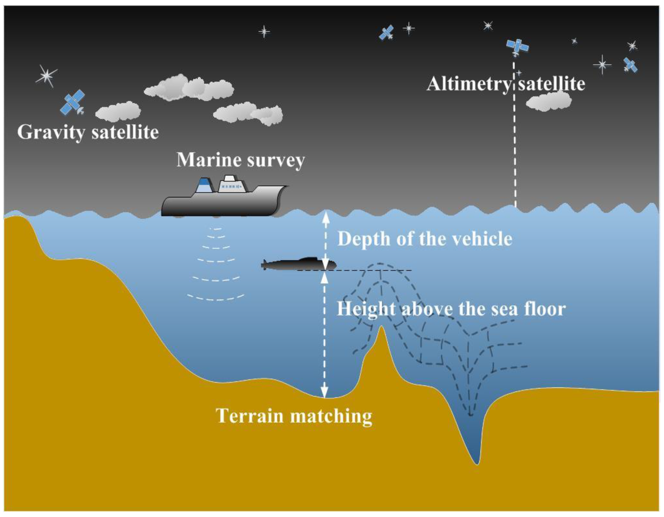
:1. Introduction
2. Materials and Methods
3. Results
3.1. Numerical Simulation and Verification of the Geodesic-Based Method
3.2. Application of the Geodesic-Based Method
4. Discussion
5. Conclusions
Author Contributions
Funding
Acknowledgments
Conflicts of Interest
References
- Zhang, J.H. Integrated navigation technology in long-range autonomous underwater vehicle. J. Proj. Rocket. Missiles Guid. 2006, 26, 183–188. [Google Scholar]
- Zhu, H.; Wang, S.J.; Cai, P. Straight-line geomagnetic matching for underwater base on ICCP. J. Chin. Inert. Technol. 2009, 17, 153–155. [Google Scholar]
- Zhang, H.W. Research on the Key Technologies of Underwater Gravity Field Aided Navigation and Positioning. Ph.D. Thesis, Harbin Engineering University, Harbin, China, 2013. [Google Scholar]
- Chen, P.Y.; Li, Y.; Su, Y.M.; Chen, X.L.; Jiang, Y.Q. Review of AUV underwater terrain matching navigation. J. Navig. 2015, 68, 1155–1172. [Google Scholar] [CrossRef]
- Zhou, J.; Ge, Z.L.; Shi, G.G.; Liu, Y.X. Key technique and development for geomagnetic navigation. J. Astronaut. 2008, 29, 1467–1472. [Google Scholar]
- Zheng, W.; Xu, H.Z.; Zhong, M.; Yun, M.J.; Zhou, X.H.; Peng, B.B. Efficient and rapid estimation of the accuracy of GRACE global gravitational field using the semi-analytical method. Chin. J. Geophys. 2008, 51, 1704–1710. [Google Scholar] [CrossRef]
- Zheng, W.; Hsu, H.; Zhong, M.; Yun, M.J.; Zhou, X.H.; Peng, B.B. Effective processing of measured data from GRACE key payloads and accurate determination of Earth’s gravitational field. Chin. J. Geophys. 2009, 52, 1966–1975. [Google Scholar] [CrossRef]
- Zheng, W.; Hsu, H.; Zhong, M.; Yun, M.J. Precise recovery of the Earth’s gravitational field with GRACE: Intersatellite Range-Rate Interpolation Approach. IEEE Geosci. Remote Sens. Lett. 2012, 9, 422–426. [Google Scholar] [CrossRef]
- Zheng, W.; Hsu, H.; Zhong, M.; Yun, M.J. Requirements analysis for future satellite gravity mission Improved-GRACE. Surv. Geophys. 2015, 36, 87–109. [Google Scholar] [CrossRef]
- Zheng, W.; Xu, H.Z.; Li, Z.W.; Wu, F. Precise establishment of the next-generation Earth gravity field model from HIP-3S based on combination of inline and pendulum satellite formations. Chin. J. Geophys. 2017, 60, 3051–3061. [Google Scholar]
- Li, X.W.; Liu, J.Y.; Kang, G.H. Development and application of TERCOM elevation aided navigation system. J. Chines Inert. Technol. 2006, 14, 34–40. [Google Scholar]
- Zhang, K.; Li, Y.; Zhao, J.H.; Rizos, C. A study of underwater terrain navigation based on the robust matching method. J. Navig. 2014, 67, 569–578. [Google Scholar] [CrossRef]
- Zhang, J.; Shen, J.; Li, H.; Rao, Z. Research and application progress on underwater terrain aided navigation technology. J. Natl. Univ. Def. Technol. 2015, 37, 128–135. [Google Scholar]
- Cheng, C.Q.; Hao, X.Y.; Zhang, Z.J.; Ma, Z.G. Robust integrated navigation algorithm of terrain aided navigation/INS. J. Chin. Inert. Technol. 2016, 24, 202–207. [Google Scholar]
- Chen, P.Y.; Li, Y.; Su, Y.M.; Chen, X.L.; Jiang, Y.Q. Underwater terrain positioning method based on least squares estimation for AUV. Chin. Ocean. Eng. 2015, 29, 859–874. [Google Scholar] [CrossRef]
- Xie, J.C.; Zhao, R.C. Studies on three terrain aided navigation methods. Meas. Control. Technol. 2007, 26, 15–18. [Google Scholar]
- Yan, C.Y.; He, R.; Cui, H.R. Summary underwater aided navigation. Technol. Innovation. 2015, 20, 15–16. [Google Scholar]
- Wang, W.; Li, S.S. Improvement of the Kalman Filtering in Gravity Anomaly Aided Navigation. In Proceedings of the China Satellite Navigation Conference, Wuhan, China, 15–17 May 2013. [Google Scholar]
- Liu, F.M.; Tang, Y.L. Application of the particle filter in INS/gravity integrated navigation based on differential evolution. Appl. Sci. Technol. 2015, 4, 15–19. [Google Scholar]
- Liu, C.X. Research on the Technologies of Underwater Terrain Aided Navigation and Positioning. Ph.D. Thesis, Harbin Engineering University, Harbin, China, 2003. [Google Scholar]
- Yan, L.; Cui, C.F.; Wu, H.L. A gravity matching algorithm based on TERCOM. Geomat. Inf. Sci. Wuhan Univ. 2009, 34, 261–264. [Google Scholar]
- Zhang, H.; Hu, X.L. A height-measuring algorithm applied to TERCOM radar altimeter. Int. Conf. Adv. Comput. Theory Eng. 2010, 5, 543–546. [Google Scholar]
- Li, S.S.; Wu, X.P.; Ma, B. Correlative extremum matching algorithm using underwater gravity anomalies. Acta Geod. Cartogr. Sin. 2011, 40, 464–469. [Google Scholar]
- Xu, K.H.; He, Y.P.; Shen, C.L. A Improved Algorithmic of Terrain Contour Forecast Matching Aided Navigation. Aeronaut. Comput. Tech. 2000, 30, 21. [Google Scholar]
- Yu, J.C.; Yan, L.; He, X. Design of TERCOM algorithm based on image layered-searching. Hydrogr. Surv. Charting 2008, 28, 33–39. [Google Scholar]
- Wang, S.P.; Zhang, H.M.; Zhao, J.H.; Tang, P. Marine geomagnetic navigation technology based on integration of TERCOM and ICCP. Geomat. Inf. Sci. Wuhan Univ. 2011, 36, 1209–1212. [Google Scholar]
- Liu, G.J.; Chen, J. Study on simulation techniques for the seabottom mapping system. Comput. Simul. 2000, 17, 21–24. [Google Scholar]
- Li, Y.; Ma, T.; Chen, P.Y.; Jiang, Y.Q.; Wang, R.P.; Zhang, Q. Autonomous underwater vehicle optimal path planning method for seabed terrain matching navigation. Ocean. Eng. 2017, 133, 107–115. [Google Scholar] [CrossRef]
- Zheng, T.; Cai, L.F.; Wang, Z.G.; Bian, S.F. Selection of matching area in terrain match aided navigation. J. Chin. Inert. Technol. 2009, 17, 191–196. [Google Scholar]
- Liu, Z.H.; Wang, H.; Cheng, B.G. Research on selection for scene matching area. Comput. Technol. Dev. 2013, 23, 128–133. [Google Scholar]
- Ma, Y.Y.; Ou, Y.Y.Z.; Huang, M.T.; Deng, K.L.; Qu, Z.H. Selection method for gravity-field matchable area based on information entropy of characteristic parameters. J. Chin. Inert. Technol. 2016, 24, 763–768. [Google Scholar]
- Rao, Z.; Zhang, J.Y.; Feng, W. Navigability evaluation method of terrain matching navigation area. J. Henan Univ. (Nat. Sci.) 2016, 46, 89–95. [Google Scholar]
- Cai, T.J.; Chen, X.W. Selection criterion based on analytic hierarchy process for matching region in gravity aided INS. J. Chin. Inert. Technol. 2013, 21, 93–96. [Google Scholar]
- Cheng, L.; Cai, T.J. Gravity matching algorithm using pattern recognition neural network. J. Chin. Inert. Technol. 2007, 15, 418–422. [Google Scholar]
- Lu, S.L.; Zhao, L.; Zhang, C.Y. Improved TERCOM based on fading factor. Int. Conf. Electr. Inf. Mechatron. 2011, 143, 770–774. [Google Scholar] [CrossRef]
- Wertz, J.R. Spacecraft Attitude Determination and Control; Springer: Dordrecht, The Netherlands, 1978; Volume 73, pp. 198–219. [Google Scholar]


| Information on Matching Point | Circular Error Probable (CEP) (m) | Search Matching Time | |||
|---|---|---|---|---|---|
| Number | Coordinates | Before Matching | Positioning Accuracy | ||
| Underwater terrain matching navigation | (a1) | 10.123° N,114.287° E | 1447.6 | 310.2 | 9.84 s |
| (b1) | 10.199° N,114.433° E | 1631.5 | 111.6 | ||
| (c1) | 10.273° N,114.579° E | 1252.6 | 102.9 | ||
| (d1) | 10.346° N,114.727° E | 1174.6 | 44.6 | ||
| Information on Matching Point | CEP (m) | Search Matching Time | |||
|---|---|---|---|---|---|
| Number | Coordinates | Before Matching | Positioning Accuracy | ||
| Underwater terrain matching navigation + geodesic-based method | (a2) | 10.124° N,114.287° E | 536.6 | 73.7 | 1.29 s |
| (b2) | 10.199° N,114.434° E | 469.3 | 96.5 | ||
| (c2) | 10.274° N,114.579° E | 560.6 | 86.9 | ||
| (d2) | 10.348° N,114.727° E | 404.4 | 53.4 | ||
© 2019 by the authors. Licensee MDPI, Basel, Switzerland. This article is an open access article distributed under the terms and conditions of the Creative Commons Attribution (CC BY) license (http://creativecommons.org/licenses/by/4.0/).
Share and Cite
Li, Z.; Zheng, W.; Wu, F. Geodesic-Based Method for Improving Matching Efficiency of Underwater Terrain Matching Navigation. Sensors 2019, 19, 2709. https://doi.org/10.3390/s19122709
Li Z, Zheng W, Wu F. Geodesic-Based Method for Improving Matching Efficiency of Underwater Terrain Matching Navigation. Sensors. 2019; 19(12):2709. https://doi.org/10.3390/s19122709
Chicago/Turabian StyleLi, Zhaowei, Wei Zheng, and Fan Wu. 2019. "Geodesic-Based Method for Improving Matching Efficiency of Underwater Terrain Matching Navigation" Sensors 19, no. 12: 2709. https://doi.org/10.3390/s19122709