Investigating Volcanic Plumes from Mt. Etna Eruptions of December 2015 by Means of AVHRR and SEVIRI Data

 , , , and
Abstract
:
1. Introduction
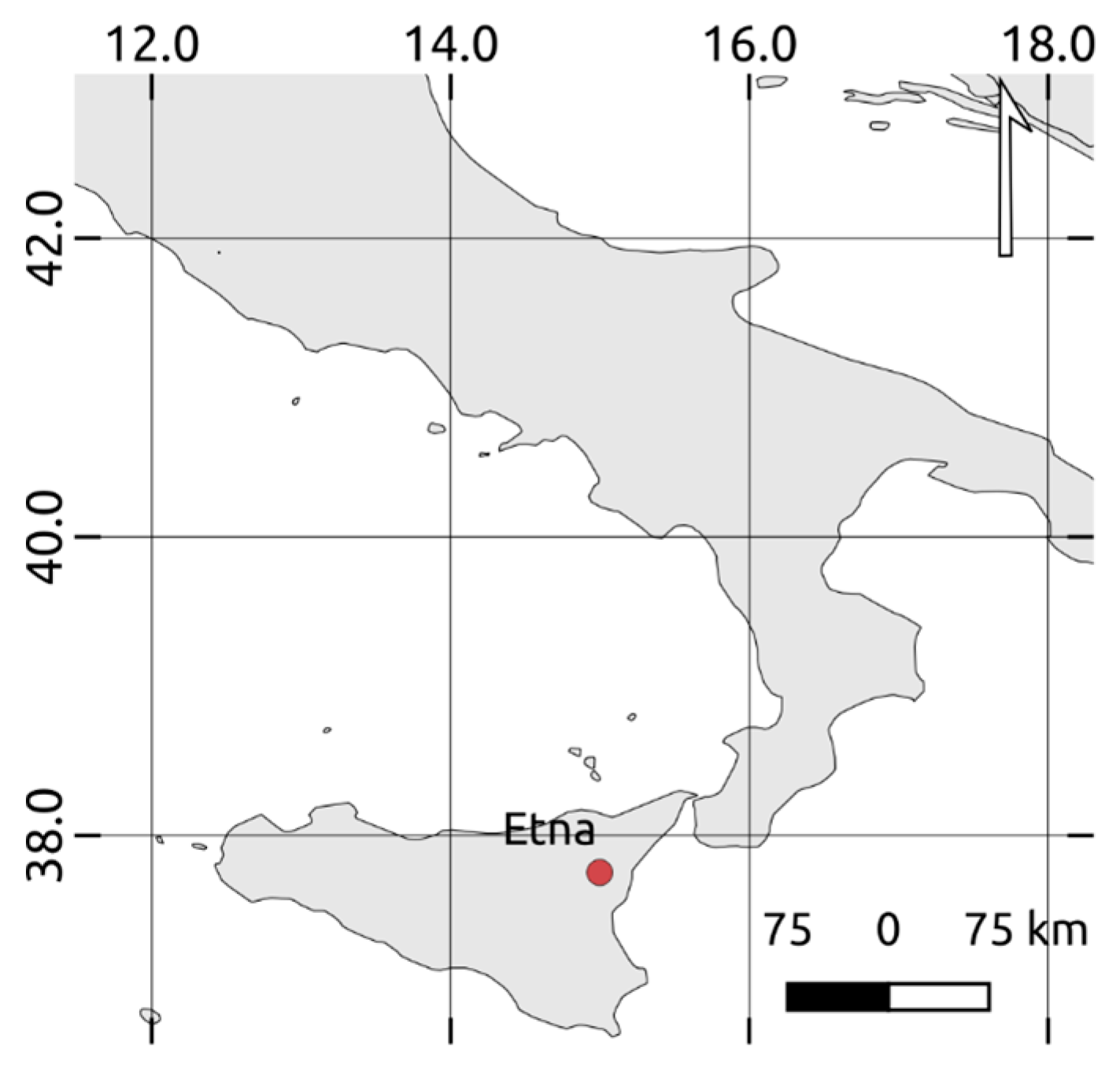
2. Data
3. Methods
3.1. RSTASH Algorithm
3.2. Plume Height and Mass Eruption Rate Estimations
4. Results
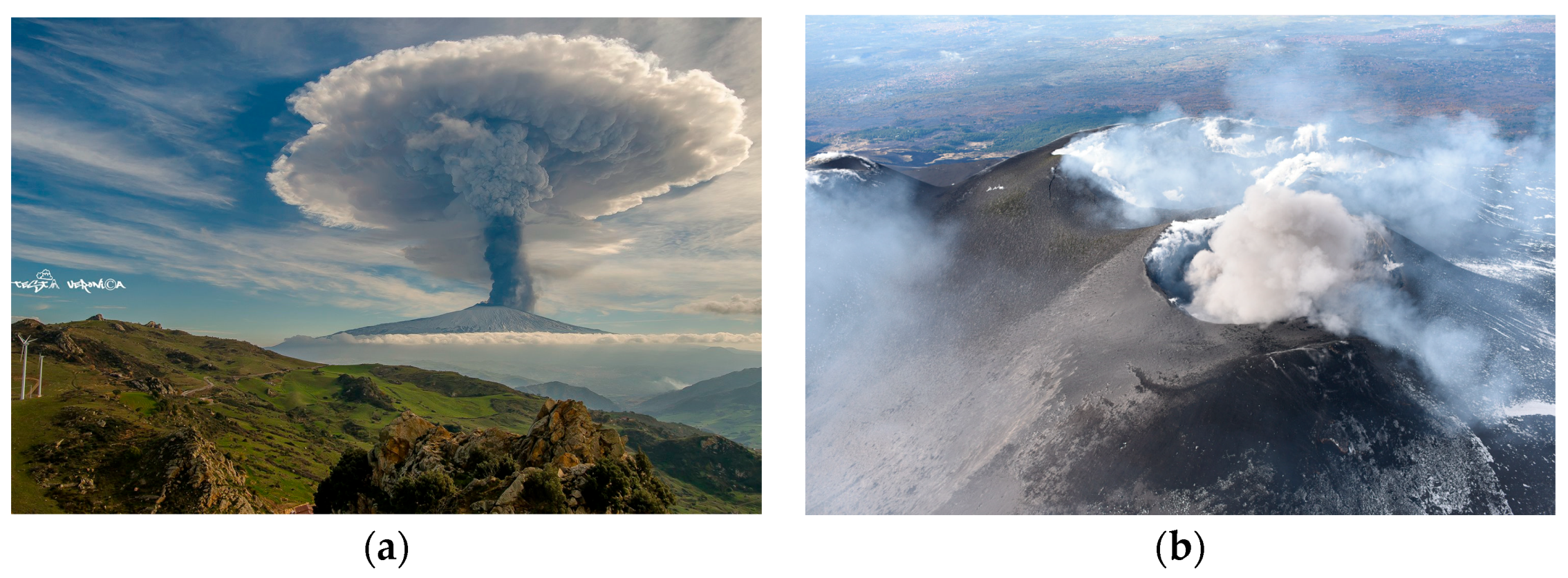
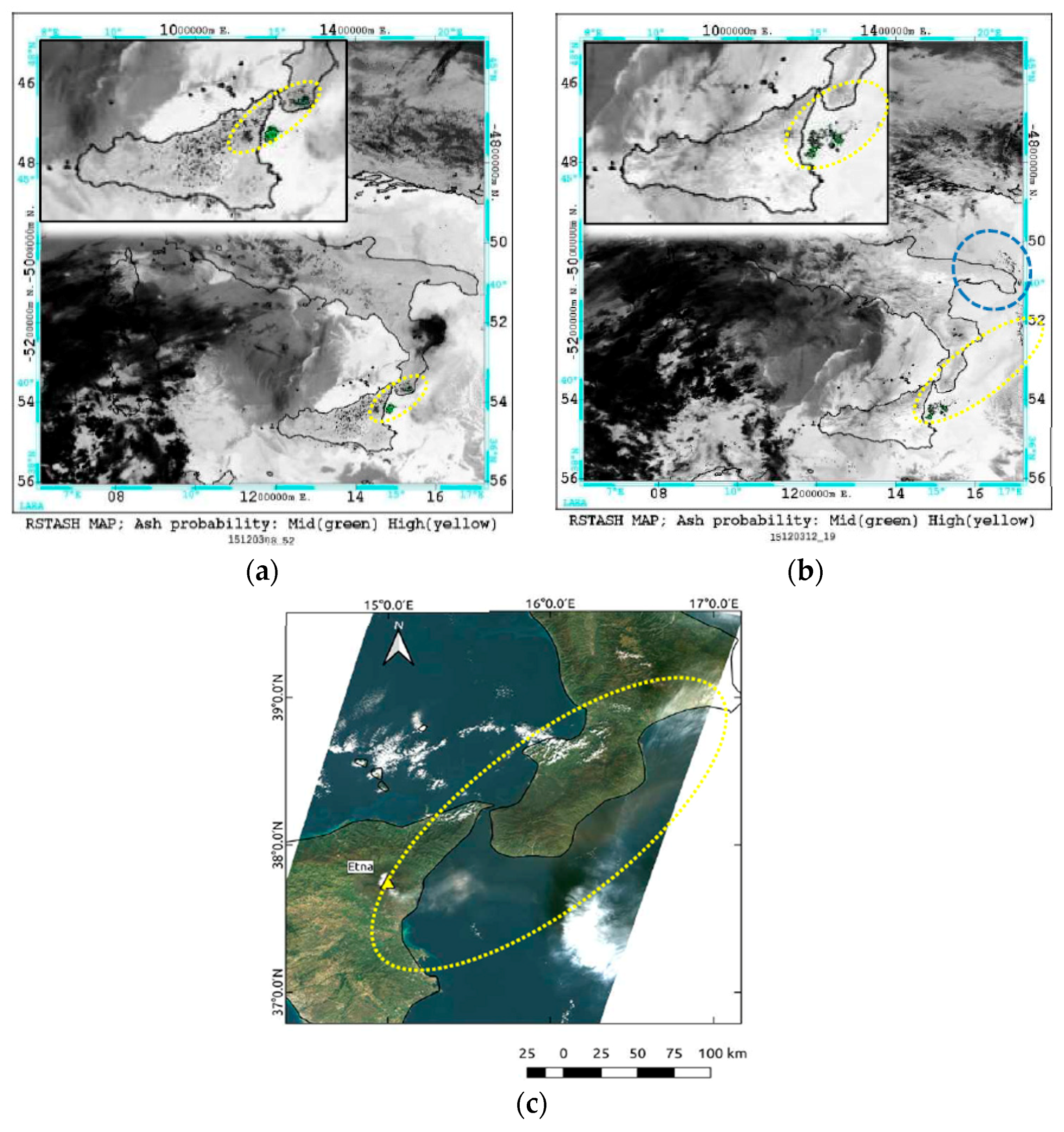
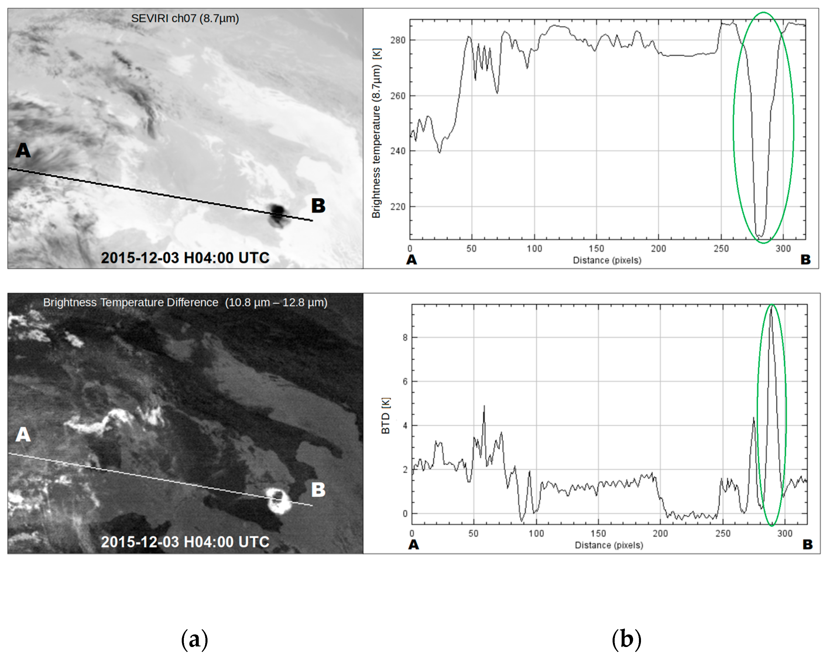
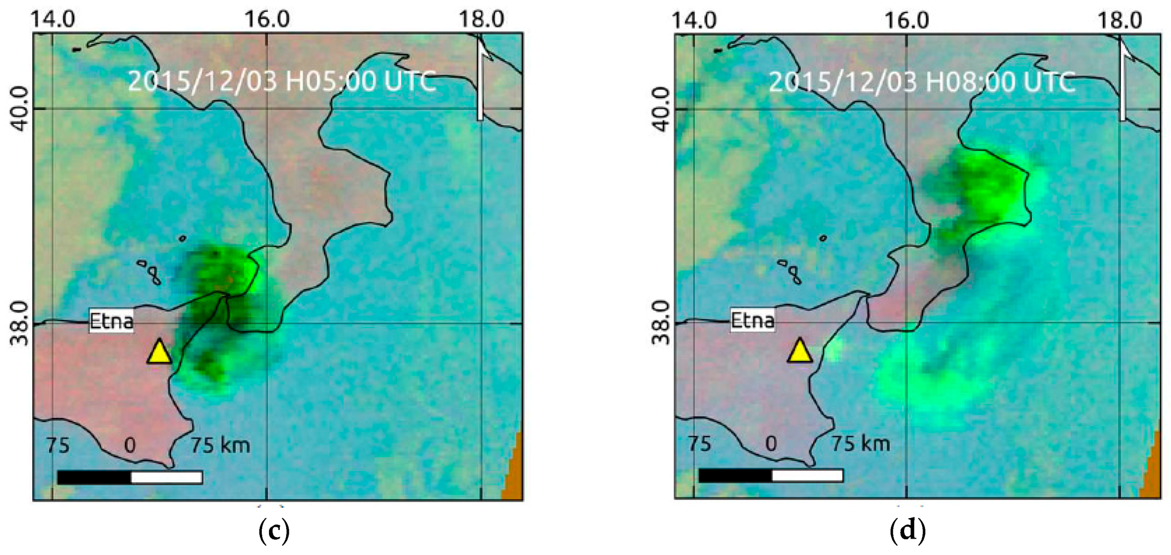
4.1. Ash Plume Detection of 3–5 December
4.2. Ash Plume Detection of 8–10 December
4.3. Estimates of Plume Height, Ash Coverage and Mass Eruption Rate
5. Discussion
6. Conclusions
Author Contributions
Funding
Acknowledgments
Conflicts of Interest
References
- Branca, S.; Del Carlo, P. Types of eruptions of Etna volcano AD 1670–2003: Implications for short-term eruptive behaviour. Bull. Volcanol. 2005, 67, 732–742. [Google Scholar] [CrossRef]
- Acocella, V.; Neri, M. What makes flank eruptions? The 2001 Etna eruption and its possible triggering mechanisms. Bull. Volcanol. 2003, 5, 517–529. [Google Scholar] [CrossRef]
- Istituto Nazionale di Geofisica e Vulcanologia, INGV, Sezione di Catania. Osservatorio Etneo. Available online: http://www.ct.ingv.it/it/11-notizie/news/1080-etna-20151210-31-breve.html (accessed on 9 January 2019).
- Corsaro, R.A.; Andronico, D.; Behncke, B.; Branca, S.; Caltabiano, T.; Ciancitto, F.; Cristaldi, A.; De Beni, E.; La Spina, A.; Lodato, L.; et al. Monitoring the December 2015 summit eruptions of Mt. Etna (Italy): Implications on eruptive dynamics. J. Volcanol. Geotherm. Res. 2017, 341, 53–69. [Google Scholar] [CrossRef]
- Pompilio, M.; Bertagnini, A.; Carlo, P.; Roberto, A. Magma dynamics within a basaltic conduit revealed by textural and compositional features of erupted ash: The December 2015 Mt. Etna paroxysms. Sci. Rep. 2017, 7, 4805. [Google Scholar] [CrossRef] [PubMed]
- Giornale di Sicilia. Available online: http://catania.gds.it/2015/12/05/emissione-di-cenere-delletna-aeroporto-chiuso-fino-alle-13_445270/ (accessed on 9 January 2019). (In Italian).
- ANSA-Calabria. Available online: http://www.ansa.it/calabria/notizie/2015/12/03/etna-chiuso-aeroporto-reggio-calabria_70baf471-48ca-4d08-b7db-4d052f37e191.html (accessed on 9 January 2019). (In Italian).
- Athanassiadou, M. The Mt Etna SO2 eruption in December 2015–the view from space. Weather 2016, 71, 273–279. [Google Scholar] [CrossRef]
- Hughes, E.J.; Yorks, J.; Krotkov, N.A.; Silva, A.M.; McGill, M. Using CATS near–real–time lidar observations to monitor and constrain volcanic sulfur dioxide (SO2) forecasts. Geophys. Res. Lett. 2016, 43, 11089–11097. [Google Scholar] [CrossRef]
- Corradini, S.; Guerrieri, L.; Lombardo, V.; Merucci, L.; Musacchio, M.; Prestifilippo, M.; Scollo, S.; Silvestri, M.; Spata, G.; Stelitano, D. Proximal Monitoring of the 2011–2015 Etna Lava Fountains Using MSG-SEVIRI Data. Geosciences 2018, 8, 140. [Google Scholar] [CrossRef]
- D’Aleo, R.; Bitetto, M.; Delle Donne, D.; Coltelli, M.; Coppola, D.; McCormick Kilbride, B.; Pecora, E.; Ripepe, M.; Salem, L.C.; Tamburello, G.; et al. Understanding the SO2 Degassing Budget of Mt Etna’s Paroxysms: First Clues from the December 2015 Sequence. Front. Earth Sci. 2019. [Google Scholar] [CrossRef]
- Pergola, N.; Tramutoli, V.; Marchese, F.; Scaffidi, I.; Lacava, T. Improving volcanic ash cloud detection by a robust satellite technique. Remote Sens. Environ. 2004, 90, 1–22. [Google Scholar] [CrossRef]
- Marchese, F.; Corrado, R.; Genzano, N.; Mazzeo, G.; Paciello, R.; Pergola, N.; Tramutoli, V. Assessment of the robust satellite technique (RST) for volcanic ash plume identification and tracking. In Use of Remote Sensing Techniques for Monitoring Volcanoes and Seismogenic Areas; USEReST: Naples, Italy, 2008. [Google Scholar] [CrossRef]
- Prata, A.J. Observations of volcanic ash clouds in the 10–12 µm window using AVHRR/2 data. Int. J. Remote Sens. 1989, 10, 751–761. [Google Scholar] [CrossRef]
- Yu, T.; Rose, W.I.; Prata, A.J. Atmospheric correction for satellite–Based volcanic ash mapping and retrievals using “split window” IR data from GOES and AVHRR. J. Geophys. Res. Atmos. 2002, 107, 10. [Google Scholar] [CrossRef]
- Ellrod, G.P.; Connell, B.H.; Hillger, D.W. Improved detection of airborne volcanic ash using multispectral infrared satellite data. J. Geophys. Res. Atmos. 2003, 108. [Google Scholar] [CrossRef] [Green Version]
- Andronico, D.; Spinetti, C.; Cristaldi, A.; Buongiorno, M.F. Observations of Mt. Etna volcanic ash plumes in 2006: An integrated approach from ground-based and polar satellite NOAA–AVHRR monitoring system. J. Volcanol. Geotherm. Res. 2009, 180, 135–147. [Google Scholar] [CrossRef]
- Kylling, A. Ash and ice clouds during the Mt Kelud February 2014 eruption as interpreted from IASI and AVHRR/3 observations. Atmos. Meas. Tech. 2016, 9, 2103–2117. [Google Scholar] [CrossRef] [Green Version]
- Aminou, D.M.A. MSG’s SEVIRI instrument. ESA Bull. 2002, 111, 15–17. [Google Scholar]
- Prata, A.J.; Kerkmann, J. Simultaneous retrieval of volcanic ash and SO2 using MSG–SEVIRI measurements. Geophys. Res. Lett. 2007, 34. [Google Scholar] [CrossRef]
- Corradini, S.; Merucci, L.; Prata, A.J. Retrieval of SO2 from thermal infrared satellite measurements: Correction procedures for the effects of volcanic ash. Atmos. Meas. Tech. 2009, 2, 177–191. [Google Scholar] [CrossRef]
- Francis, P.N.; Cooke, M.C.; Saunders, R.W. Retrieval of physical properties of volcanic ash using Meteosat: A case study from the 2010 Eyjafjallajökull eruption. J. Geophys. Res. Atmos. 2012, 117. [Google Scholar] [CrossRef] [Green Version]
- Tramutoli, V. Robust Satellite Techniques (RST) for Natural and Environmental Hazards Monitoring and Mitigation: Theory and Applications. Proc. Multitemp. 2007. [Google Scholar] [CrossRef]
- Marchese, F.; Falconieri, A.; Pergola, N.; Tramutoli, V. A retrospective analysis of the Shinmoedake (Japan) eruption of 26–27 January 2011 by means of Japanese geostationary satellite data. J. Volcanol. Geotherm. Res. 2014, 269, 1–13. [Google Scholar] [CrossRef]
- Marchese, F.; Malvasi, G.; Ciampa, M.; Filizzola, C.; Pergola, N.; Tramutoli, V. A robust multitemporal satellite technique for volcanic activity monitoring: Possible impacts on volcanic hazard mitigation. In Proceedings of the 2007 International Workshop on the Analysis of Multi-temporal Remote Sensing Images, Leuven, Belgium, 18–20 July 2007; pp. 1–5. [Google Scholar] [CrossRef]
- Marchese, F.; Falconieri, A.; Pergola, N.; Tramutoli, V. Monitoring the Agung (Indonesia) Ash Plume of November 2017 by Means of Infrared Himawari 8 Data. Remote Sens. 2018, 10, 919. [Google Scholar] [CrossRef]
- Falconieri, A.; Cooke, M.C.; Filizzola, C.; Marchese, F.; Pergola, N.; Tramutoli, V. Comparing Two Independent Satellite-Based Algorithms for Detecting and Tracking Ash Clouds by Using SEVIRI Sensor. Sensors 2018, 18, 369. [Google Scholar] [CrossRef] [PubMed]
- Virtanen, T.H.; Kolmonen, P.; Rodríguez, E.; Sogacheva, L.; Sundström, A.M.; de Leeuw, G. Ash plume top height estimation using AATSR. Atmos. Meas. Tech. 2014, 7, 2437–2456. [Google Scholar] [CrossRef] [Green Version]
- Kienle, J.; Shaw, G.E. Plume dynamics, thermal energy and long distance transport of vulcanian eruption clouds from Augustine volcano, Alaska. J. Volcanol. Geotherm. Res. 1979, 6, 139–164. [Google Scholar] [CrossRef]
- Prata, A.J.; Turner, P.J. Cloud-top height determination using ATSR data. Remote Sens. Environ. 1997, 59, 1–13. [Google Scholar] [CrossRef]
- Richards, M.S.; Ackerman, S.A.; Pavolonis, M.J.; Feltz, W.F.; Tupper, A. Volcanic Ash Cloud Heights Using the MODIS CO2-Slicing Algorithm; CIMSS University of Wisconsin-Madison, Department of Atmospheric and Oceanic Sciences: Madison, WI, USA, 2006. [Google Scholar]
- Zakšek, K.; Hort, M.; Zaletelj, J.; Langmann, B. Monitoring volcanic ash cloud top height through simultaneous retrieval of optical data from polar orbiting and geostationary satellites. Atmos. Chem. Phys. 2013, 13, 2589–2606. [Google Scholar] [CrossRef] [Green Version]
- Sawada, Y. Study on Analysis of Volcanic Eruptions Based on Eruption Cloud Image Data Obtained by the Geostationary Meteorological Satellite (GMS); Meteorology Research Institute: Tokyo, Japan, 1987; p. 335. [Google Scholar]
- Glaze, L.S.; Francis, P.W.; Self, S.; Rothery, D.A. The 16th September 1986 eruption of Lascar volcano, north Chile: Satellite investigations. Bull. Volcanol. 1989, 51, 149–160. [Google Scholar] [CrossRef]
- Oppenheimer, C. Volcanological applications of meteorological satellites. Int. J. Remote Sens. 1998, 10, 2829–2864. [Google Scholar] [CrossRef]
- Webley, P.W.; Mastin, L.G. Improved prediction and tracking of volcanic ash clouds. J. Volcanol. Geotherm. Res. 2009. [Google Scholar] [CrossRef]
- Mastin, L.G.; Guffanti, M.; Servranckx, R.; Webley, P.; Barsotti, S.; Dean, K.; Durant, A.; Ewert, J.W.; Neri, A.; Rose, W.I.; et al. A multidisciplinary effort to assign realistic source parameters to models of volcanic ash-cloud transport and dispersion during eruptions. J. Volcanol. Geotherm. Res. 2009, 186, 10–21. [Google Scholar] [CrossRef] [Green Version]
- Sparks, R.S.J.; Bursik, M.I.; Carey, S.N.; Gilbert, J.S.; Glaze, L.S.; Sigurdsson, H.; Woods, A.W. Volcanic Plumes; John Wiley: New York, NY, USA, 1997; p. 574. [Google Scholar]
- Mastin, L.G. Testing the accuracy of a 1–D volcanic plume model in estimating mass eruption rate. J. Geophys. Res. Atmos. 2014, 119, 2474–2495. [Google Scholar] [CrossRef]
- Woodhouse, M.J.; Hogg, A.J.; Phillips, J.C.; Sparks, R.S.J. Interaction between volcanic plumes and wind during the 2010 Eyjafjallajökull eruption, Iceland. J. Geophys. Res. Solid Earth 2013, 118, 92–109. [Google Scholar] [CrossRef] [Green Version]
- Steensen, B.M.; Kylling, A.; Kristiansen, N.I.; Schulz, M. Uncertainty assessment and applicability of an inversion method for volcanic ash forecasting. Atmos. Chem. Phys. 2017, 17, 9205–9222. [Google Scholar] [CrossRef] [Green Version]
- Romano, S.; Burlizzi, P.; Kinne, S.; De Tomasi, F.; Hamann, U.; Perrone, M.R. Radiative impact of Etna volcanic aerosols over south eastern Italy on 3 December 2015. Atmos. Environ. 2018, 182, 155–170. [Google Scholar] [CrossRef]
- Smiljanic, I.; Setvak, M.; Prata, F.; Kerkmann, J. On 3 December, for the first time in two years Mount Etna, erupted.” EUMETSAT Image Library (blog), EUMETSAT, December 2015. Available online: http://www.eumetsat.int/website/home/Images/ImageLibrary/DAT_2868529.html (accessed on 17 January 2019).
- Support to Aviation Control Service (SACS). Available online: http://sacs.aeronomie.be/ (accessed on 17 January 2019).
- Volcanic Ash Monitoring Product Guide–EUMETSAT. Available online: https://www.eumetsat.int/website/wcm/idc/idcplg?IdcService=GET_FILE&dDocName=PDF_VOL_PG&RevisionSelectionMethod=LatestReleased&Rendition=Web (accessed on 17 January 2019).
- SEVIRI Ash RGB Product Quick Guide–EUMETSAT. Available online: https://www.eumetsat.int/website/wcm/idc/idcplg?IdcService=GET_FILE&dDocName=PDF_RGB_QUICK_GUIDE_ASH&RevisionSelectionMethod=LatestReleased&Rendition=Web (accessed on 17 January 2019).
- Kalnay, E.; Kanamitsu, M.; Kistler, R.; Collins, W.; Deaven, D.; Gandin, L.; Iredell, M.; Saha, S.; White, G.; Woollen, J.; et al. The NCEP/NCAR 40-year reanalysis project. Bull. Am. Meteorol. Soc. 1996, 77, 437–470. [Google Scholar] [CrossRef]
- Steffke, A.M.; Fee, D.; Garces, M.; Harris, A. Eruption chronologies, plume heights and eruption styles at Tungurahua Volcano: Integrating remote sensing techniques and infrasound. J. Volcanol. Geotherm. Res. 2010, 193, 143–160. [Google Scholar] [CrossRef]
- Bonaccorso, A.; Calvari, S. A new approach to investigate an eruptive paroxysmal sequence using camera and strainmeter networks: Lessons from the 3–5 December 2015 activity at Etna volcano. Earth Planet. Sci. Lett. 2017, 475, 231–241. [Google Scholar] [CrossRef]
- NASA VIIRS Level-1 User Guide–Laads Daac. Available online: https://ladsweb.modaps.eosdis.nasa.gov/missions-and-measurements/viirs/NASA_VIIRS_L1B_UG_May_2018.pdf (accessed on 23 February 2019).
- Vulpiani, G.; Ripepe, M.; Valade, S. Mass discharge rate retrieval combining weather radar and thermal camera observations. J. Geophys. Res. Solid Earth 2016, 121, 5679–5695. [Google Scholar] [CrossRef] [Green Version]
- Calvari, S.; Cannavo, F.; Bonaccorso, A.; Spampinato, L.; Pellegrino, A.G. Paroxysmal explosions, lava fountains and ash plumes at Etna volcano: Eruptive processes and hazard implications. Front. Earth Sci. 2018, 6, 1–20. [Google Scholar] [CrossRef]
- Sigurdsson, H.; Houghton, B.; McNutt, S.; Rymer, H.; Stix, J. The Encyclopedia of Volcanoes; Elsevier: Amsterdam, The Netherlands, 2015. [Google Scholar]
- Freret-Lorgeril, V.; Donnadieu, F.; Scollo, S.; Provost, A.; Fréville, P.; Guéhenneux, Y.; Hervier, C.; Prestifilippo, M.; Coltelli, M. Mass Eruption Rates of tephra plumes during the 2011–2015 lava fountain paroxysms at Mt. Etna from Doppler radar retrievals. Front. Earth Sci. 2018, 6, 1–16. [Google Scholar] [CrossRef]


| Satellite Overpass Time (YYMMDD_hhmm) | Plume Height Range (km a.s.l.) | Ash Coverage (km2) |
|---|---|---|
| 151208_0533 151208_0837 | 3.2–4.4 3.2–4.4 | 49.4 58.8 |
| 151208_1959 | 4.4–5.8 | 172.8 |
| 151209_0150 151209_0522 151209_0816 151209_0903 | 4.4–5.8 1.6–3.2 3.2–4.4 3.2–4.4 | 1173.3 1450.7 351 1530 |
| 151209_1631 | 3.2–4.4 | 639.5 |
| 151209_1938 | 3.2–4.4 | 91.7 |
| 151210_0510 | 3.2–4.4 | 76.4 |
© 2019 by the authors. Licensee MDPI, Basel, Switzerland. This article is an open access article distributed under the terms and conditions of the Creative Commons Attribution (CC BY) license (http://creativecommons.org/licenses/by/4.0/).
Share and Cite
Marchese, F.; Falconieri, A.; Filizzola, C.; Pergola, N.; Tramutoli, V. Investigating Volcanic Plumes from Mt. Etna Eruptions of December 2015 by Means of AVHRR and SEVIRI Data. Sensors 2019, 19, 1174. https://doi.org/10.3390/s19051174
Marchese F, Falconieri A, Filizzola C, Pergola N, Tramutoli V. Investigating Volcanic Plumes from Mt. Etna Eruptions of December 2015 by Means of AVHRR and SEVIRI Data. Sensors. 2019; 19(5):1174. https://doi.org/10.3390/s19051174
Chicago/Turabian StyleMarchese, Francesco, Alfredo Falconieri, Carolina Filizzola, Nicola Pergola, and Valerio Tramutoli. 2019. "Investigating Volcanic Plumes from Mt. Etna Eruptions of December 2015 by Means of AVHRR and SEVIRI Data" Sensors 19, no. 5: 1174. https://doi.org/10.3390/s19051174