Using Ground Penetrating Radar to Reveal Hidden Archaeology: The Case Study of the Württemberg-Stambol Gate in Belgrade (Serbia)


 , ,
, ,
Abstract
: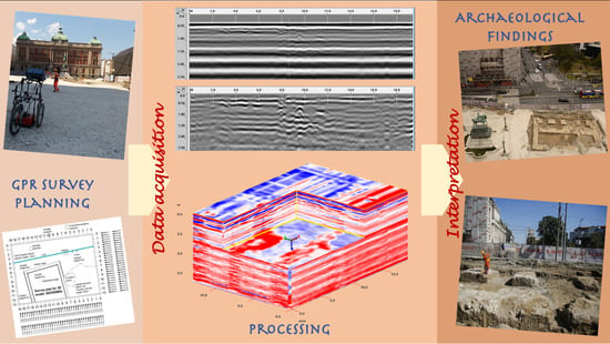
1. Introduction
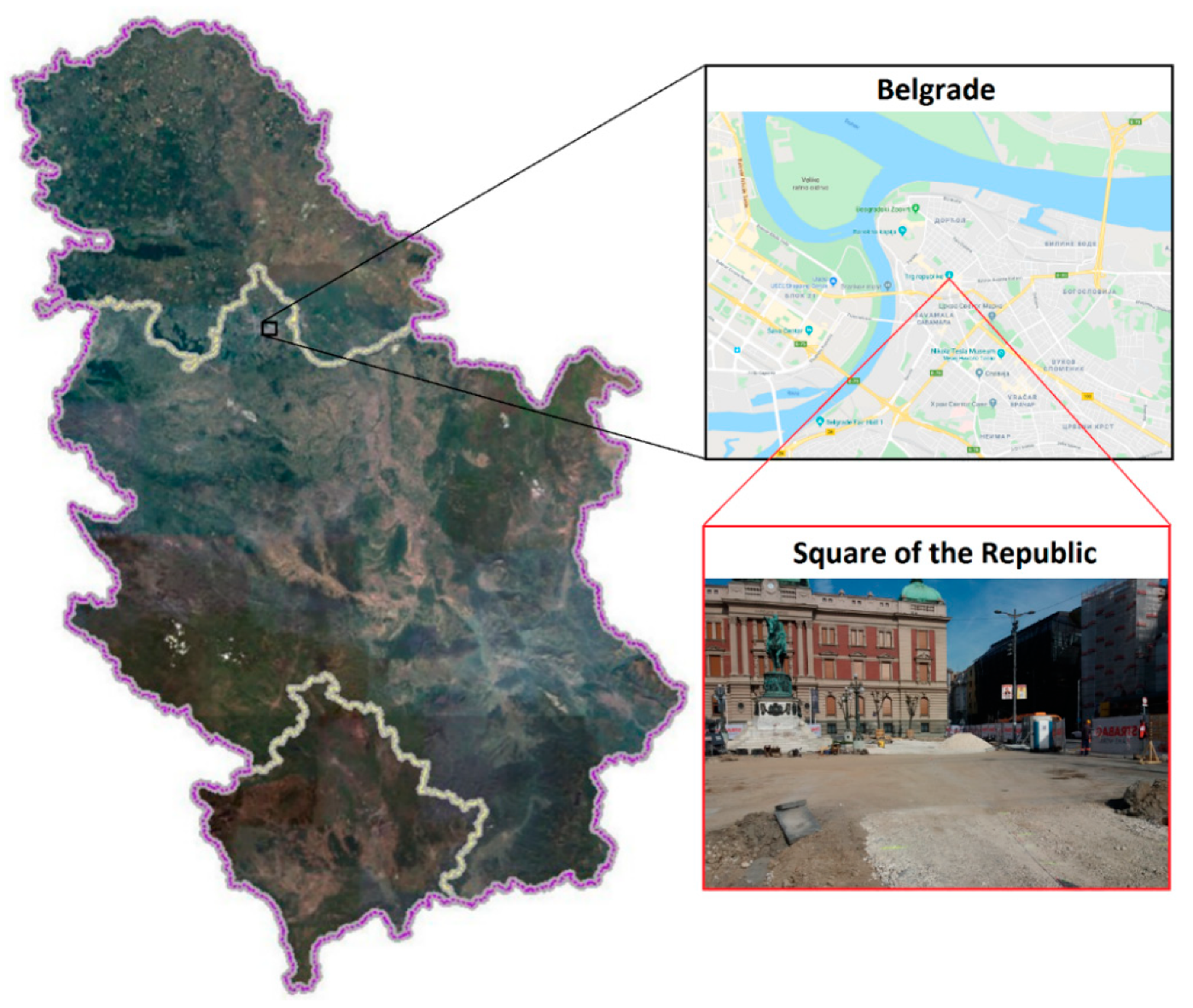
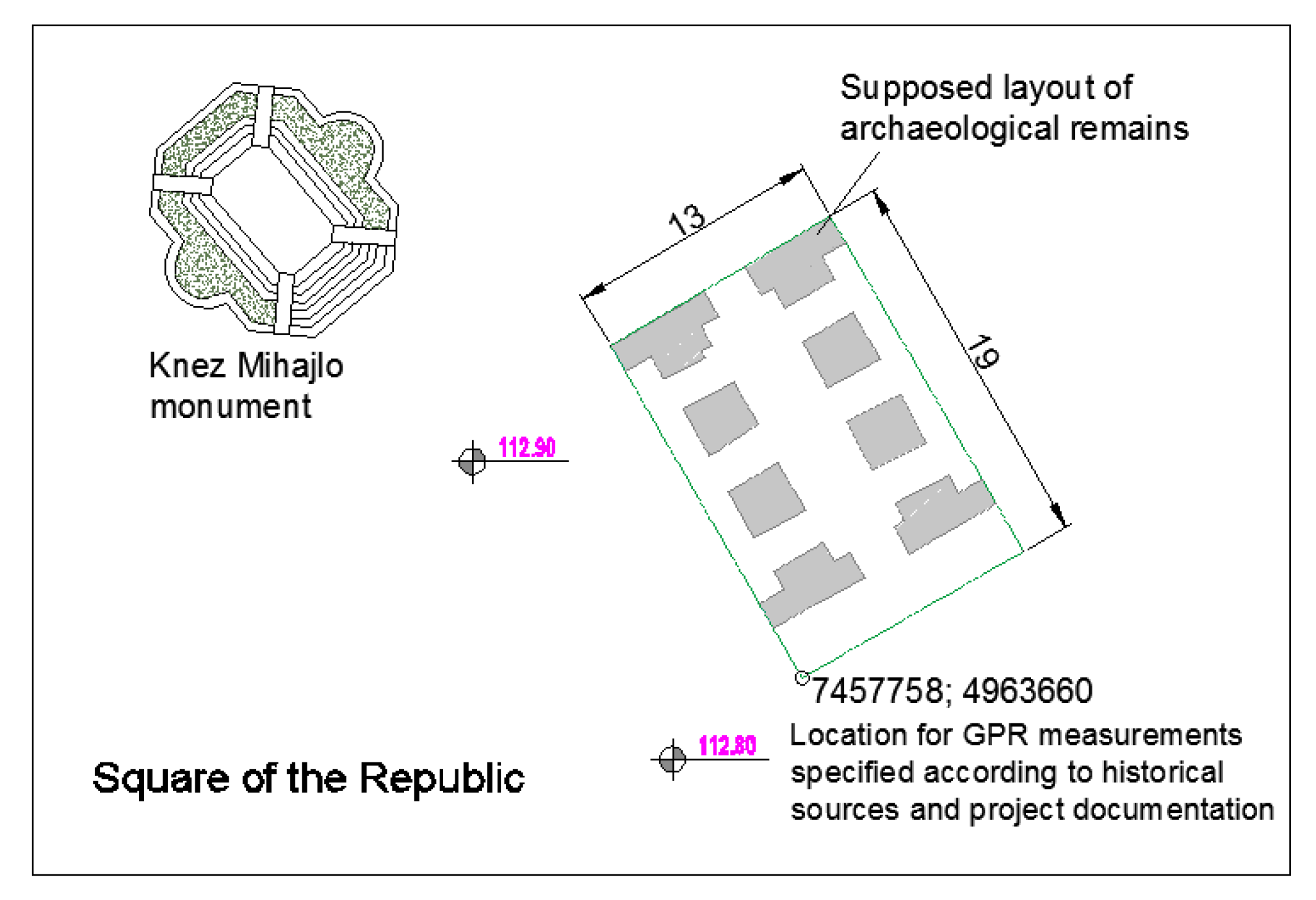
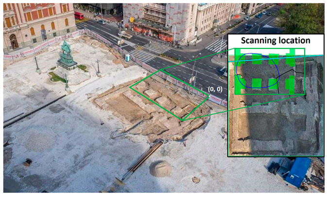
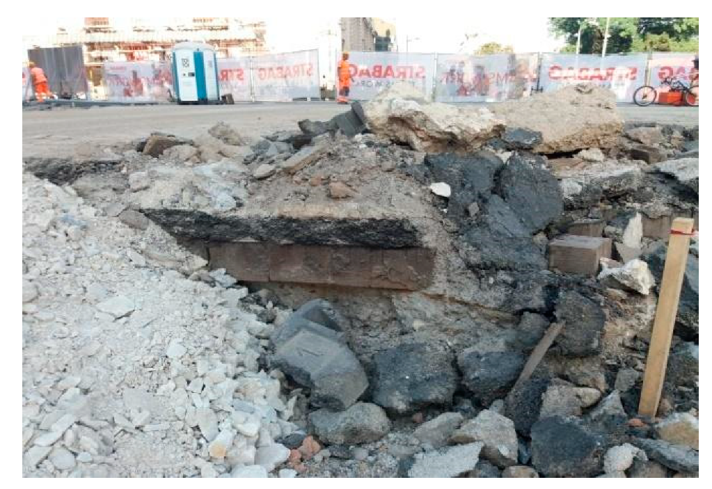
2. The Survey Area and Sought Archaeological Remains
3. Methodology
3.1. Survey Planning and Data Acquisition Strategy
- (1)
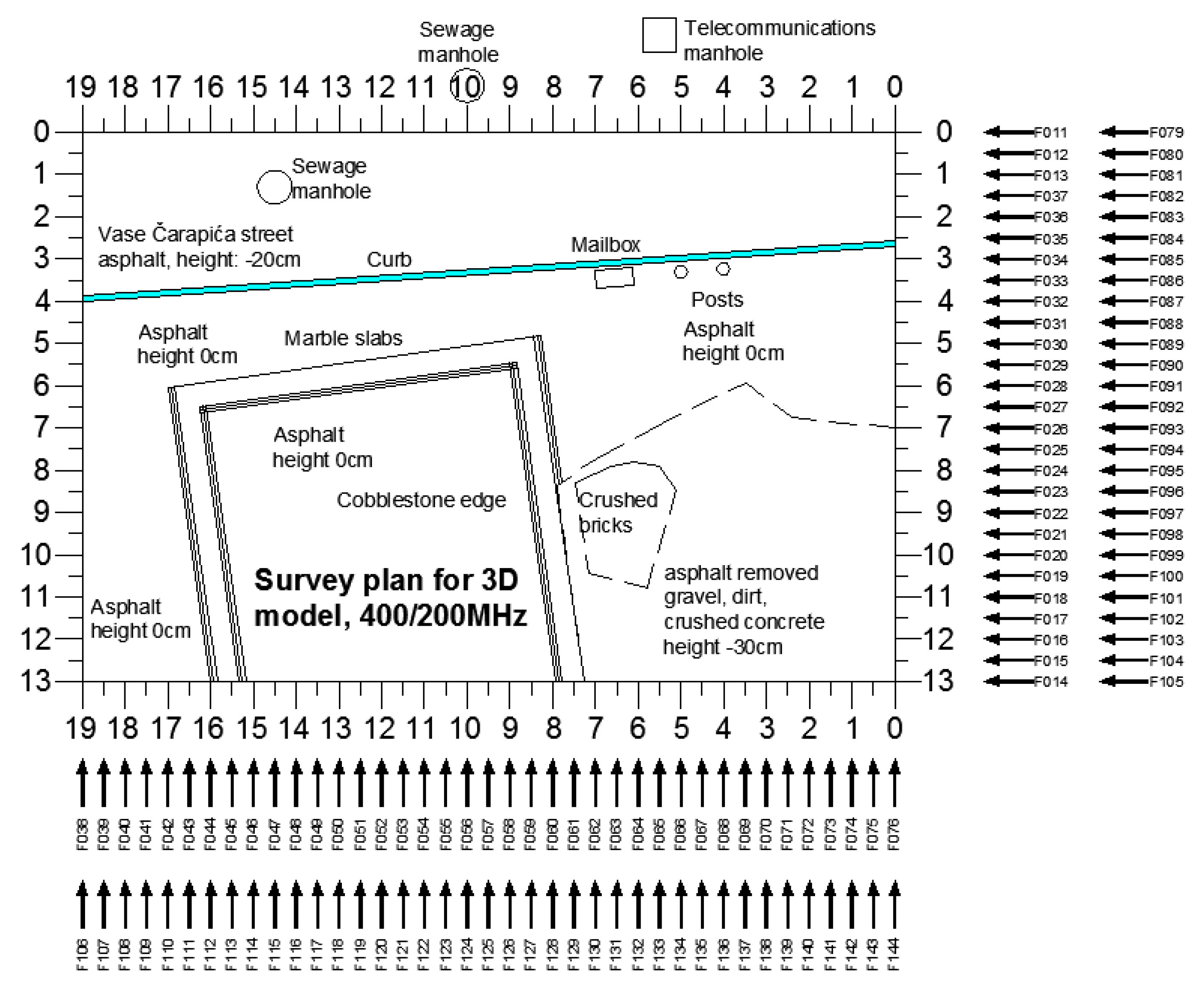
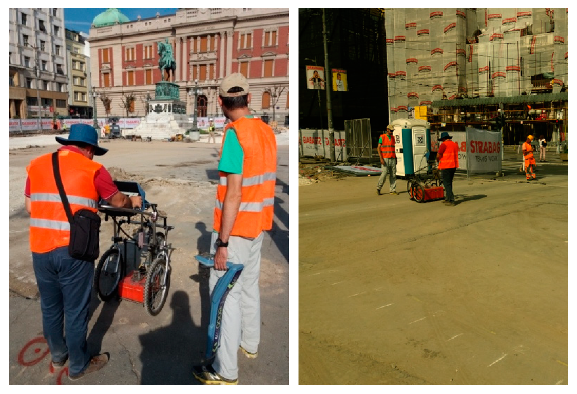
- Marking of the 19 m × 13 m zone that included the region of interest. This step was done by using a Global Navigation Satellite System (GNSS) device and terrestrial stake-out of the points with coordinates read from cadastral plans [38].
- (2)
- Estimation of the average propagation velocity of electromagnetic waves (or the average relative permittivity of the soil) in the region of the survey. Such information is used to determine the most appropriate distance between adjacent acquisition lines and it is crucial to set the time window and calibrate the GPR data, i.e., to transform time into distances. The estimation of the average wave velocity was accomplished by scanning underground utilities at known depth [39,40]. Since there were several manholes in the zone, with utilities 1 to 2 m deep, this procedure was repeated many times to find a representative value of the velocity. The estimated value was v = 0.106 [m/ns], which corresponds to a relative permittivity εR = 8. Based on these observations, the average wavelength λ in the soil was calculated for both the antenna central frequencies 400 MHz and 200 MHz (see Table 1).
- (3)
- Verifying that the chosen vertical scanning resolution satisfied Nyquist sampling criterion. According to Nyquist sampling criterion, the vertical scanning resolution has to be Δy ≤ 0.25λ [41,42]. When using the 400 MHz antennas, the time window was chosen by taking into account the estimated value of v and to achieve a scanning depth of 2 m; with 512 samples per trace, it was easy to check that Nyquist criterion was satisfied (2 m/512 = 0.039 m < 0.066 m, Table 1). When using the 200 MHz antennas, the desired scanning depth was 4 m and the vertical resolution was again 512 samples/scan, hence Nyquist condition was satisfied in this case too (4 m/512 = 0.0078 m < 0.1325 m, Table 1).
- (4)
- Choosing an appropriate distance between adjacent acquisition lines (profile spacing, PS). PS plays a decisive role in GPR archaeological prospection [43]. A denser profile spacing yields better horizontal resolution, higher quality of horizontal slice images and easier data interpretation—but is time consuming, hence expensive. Obviously, it is not realistic to acquire infinitely dense GPR profiles and in practice it is always necessary to balance between survey resolution and its cost; interpolation techniques are widely used to fill data gaps between adjacent profiles [43]. In some cases, different PS values may be chosen along different grid axes. All things considered, a good value for PS can be chosen in various ways, as summarized in the following:
- (a)
- Full resolution scanning [41]–this approach provides a horizontal resolution that eliminates the need for interpolation. Results obtained using this procedure are the best, especially for archaeological prospection, but they are very time consuming. The approach requires that the chosen PS satisfies Nyquist sampling criterion, i.e., PS ≤ 0.25λ. In the case study presented herein, PS should therefore be about 7 cm for the 400 MHz antennas and about 14 cm for the 200 MHz antennas. If higher frequency values are used in this calculation, taking into account that the emitted pulse has a wide spectrum, PS becomes even smaller. Such a dense profiling is very difficult to obtain in field conditions: grid marking on the ground would take too much time and be tedious, as well as the acquisition itself. This approach is applicable only in case of ideal ground surface and without time constraints for the acquisition.
- (b)
- Definition of PS based on the expected size of the sought targets and distance between adjacent targets–This is the simplest and most common approach, wherein the chosen PS is no larger than the expected size of the sought objects and no larger than the distance between adjacent objects [44,45,46]. In the case study presented in this paper this approach was adopted and PS = 0.5 m was chosen. On the 19 m × 13 m grid, 39 + 27 = 66 radargrams were therefore collected, whereas the application of the full resolution scanning approach would have required the collection 186 + 272 = 458 radargrams with the 400 MHz antennas, and 98 + 136 = 229 radargrams with the 200 MHz antennas.
- (c)
- Definition of PS based on the analysis of a f-k (frequency-wavenumber) plot of a densely sampled, representative radargram. This is an often-practiced graphical procedure that has to be executed in the field by the GPR operator, taking into account also the maximum radiation angle of the GPR antenna over the specific soil where the survey is carried out. This approach was not used in the present case study and it is not discussed further in this paper, but a detailed explanation can be found in [41].
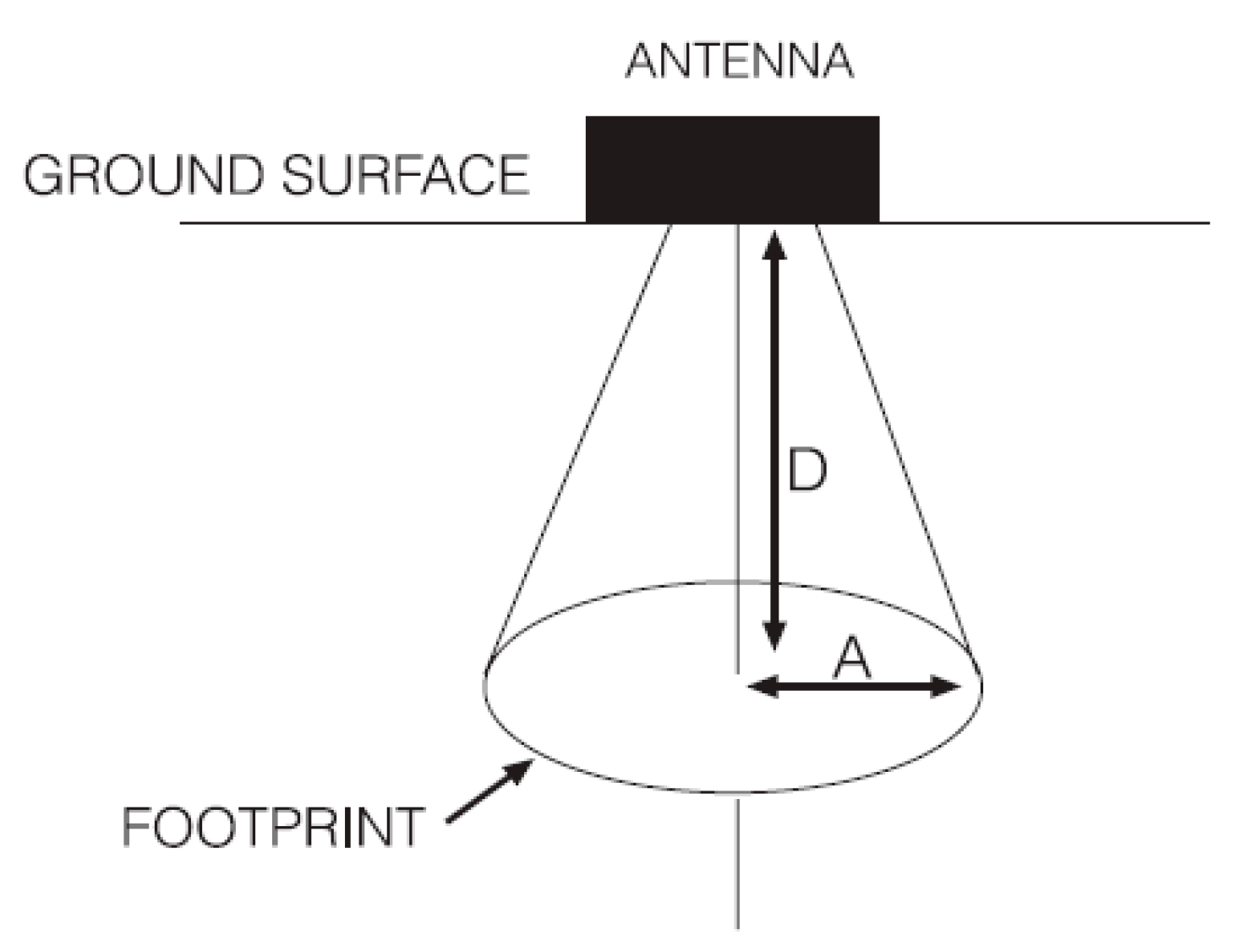
- (d)
- Calculation of PS based on the antenna footprint (Figure 3)–In this method, the calculation of the antenna footprint at a given depth is used to choose an appropriate spatial resolution. In particular, the radius of the antenna footprint is the minimum value of PS that guarantees full coverage of the area of interest at a given depth. Different equations can be used to estimate the antenna footprint, based on different empirical definitions of the Fresnel distance. According to [5]:and according to [44]:where A is the radius of the antenna footprint, λ is again the wavelength at the central frequency f of the used antennas, v is the wave velocity, D is the depth from the ground surface to the reflection surface where the antenna footprint is calculated, and εR is the average relative dielectric permittivity of the material from the ground surface to the depth D. For the antennas used in this paper and given conditions in the field, the resulting values of A when D = 1 m and D = 2 m are reported in Table 1. The expected depth of the sought targets was between 0.5 m and 1.8 m, and the values of A at 1 m and 2 m, according to equations (1) and (2), were between 0.37 m and 0.8 m. These results confirm that PS = 0.5 m is a reasonable value.
- (e)
- In [44], it is suggested to use PS < 4λ, which in the present case study yields a minimum PS of 1.06 m and 2.12 m with 400 MHz and 200 MHz antennas, respectively. This further confirms that PS = 0.5 m was an appropriate choice for both sets of antennas.
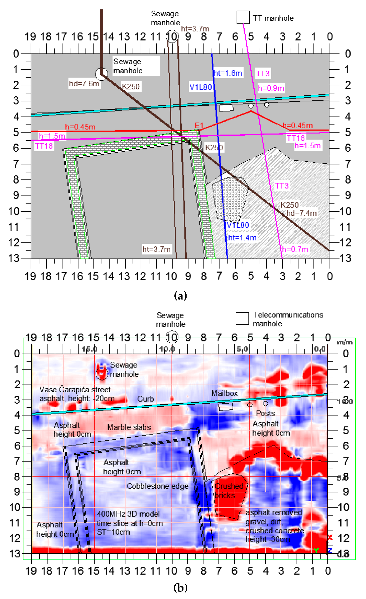
- Sewage pipe K250: concrete pipe with Nominal Diameter DN = 250 mm, at 7 m depth;
- Telecommunication cable TT16: bunch of cables in a protective PVC tube with DN = 80 mm, at 1.5 m depth;
- Telecommunication cable TT3: bunch of cables in a protective PVC tube with DN = 80 mm, at unknown depth;
- Waterline V1L80: metal pipe with DN = 80 mm, at unknown depth;
- Powerline, at 0.6 m depth.
3.2. Data Editing and Processing
4. Results and Discussion
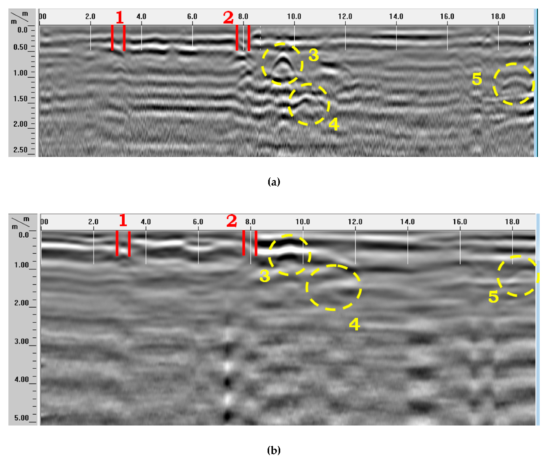
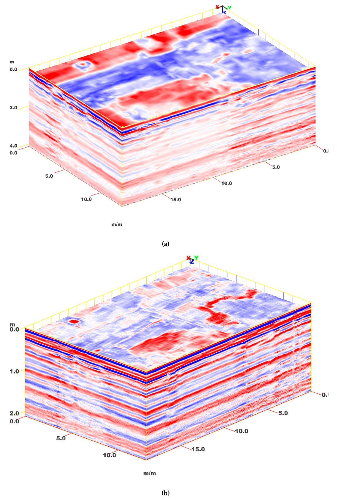
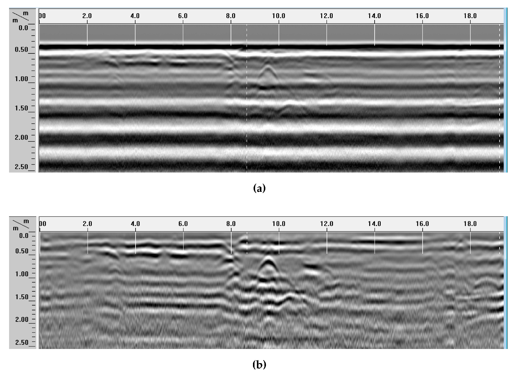
4.1. B-scans
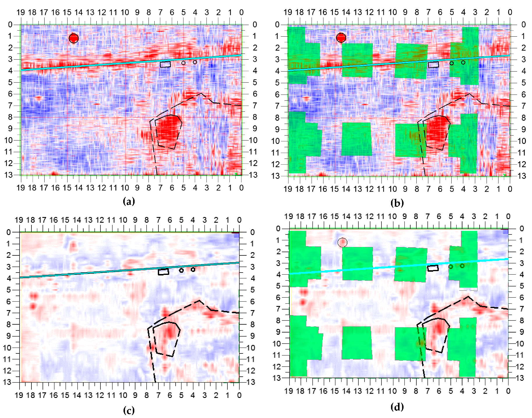
4.2. C-scans and Horizontal Slices
5. Conclusions
Author Contributions
Funding
Acknowledgments
Conflicts of Interest
References
- Persico, R. Introduction to Ground Penetrating Radar: Inverse Scattering and Data Processing; Wiley-IEEE Press: Hoboken, NJ, USA, 2014; p. 392. [Google Scholar]
- Benedetto, A.; Pajewski, L. (Eds.) Civil Engineering Applications of Ground Penetrating Radar; Springer Transactions in Civil and Environmental Engineering; Springer International: New Delhi, India, 2015; p. 385. [Google Scholar]
- Dérobert, X.; Pajewski, L. TU1208 Open Database of Radargrams: The Dataset of the IFSTTAR Geophysical Test Site. Remote Sens. 2018, 10, 530. [Google Scholar] [CrossRef] [Green Version]
- Conyers, L.B. Interpreting Ground-Penetrating Radar for Archaeology; Routledge, Taylor and Francis Group: New York, NY, USA, 2014; p. 214. [Google Scholar]
- Conyers, L.B.; Goodman, B. Ground-Penetrating Radar: An Introduction for Archaeologists; AltaMira Press: Walnut Creek, CA, USA; London, UK; New Delhi, India, 1997; p. 232. [Google Scholar]
- Urban, T.M.; Murray, C.A.; Vella, C.; Lahikainen, A. Ground-penetrating radar survey on the island of Pantelleria (Italy) reveals an ancient architectural complex with likely Punic and Roman components. J. Appl. Geophys. 2015, 123, 164–169. [Google Scholar] [CrossRef]
- Malfitana, D.; Leucci, G.; Fragalà, G.; Masini, N.; Scardozzi, G.; Cacciaguerra, G.; Santagati, C.; Shehi, E. The potential of integrated GPR survey and aerial photographic analysis of historic urban areas: A case study and digital reconstruction of a Late Roman villa in Durrës (Albania). J. Archaeol. Sci. 2015, 4, 276–284. [Google Scholar] [CrossRef] [Green Version]
- Deiana, R.; Leucci, G.; Martorana, R. New Perspectives on Geophysics for Archaeology: A Special Issue. Surv. Geophys. 2018, 39, 1035–1038. [Google Scholar] [CrossRef] [Green Version]
- Fontul, S.; Solla, M.; Cruz, H.; Machado, J.S.; Pajewski, L. Ground Penetrating Radar Investigations in the Noble Hall of São Carlos Theater in Lisbon, Portugal. Surv. Geophys. 2018, 39, 1125–1147. [Google Scholar] [CrossRef]
- Di Giacomo, G.; De Giorgi, L.; Ditaranto, I.; Leucci, G.; Miccoli, I.; Scardozzi, G. The Medieval cave village of Casalrotto (Mottola, Apulia): New data on the settlement and its necropolis from archaeological and geophysical measurements. Measurement 2018, 128, 96–103. [Google Scholar] [CrossRef]
- Persico, R.; D’Amico, S. Use of Ground Penetrating Radar and standard geophysical methods to explore the subsurface. Ground Penetrating Radar 2018, 1, 1–37. [Google Scholar] [CrossRef]
- Persico, R.; D’Amico, S.; Rizzo, E.; Capozzoli, L.; Micallef, A. Ground Penetrating Radar investigations in sites of cultural interest in Malta. Ground Penetrating Radar 2018, 1, 38–61. [Google Scholar]
- Bianco, C.; De Giorgi, L.; Giannotta, M.T.; Leucci, G.; Meo, F.; Persico, R. The Messapic Site of Muro Leccese: New Results from Integrated Geophysical and Archaeological Surveys. Remote Sens. 2019, 11, 1478. [Google Scholar] [CrossRef] [Green Version]
- Caspari, G.; Sadykov, T.; Blochin, J.; Buess, M.; Nieberle, M.; Balz, T. Integrating Remote Sensing and Geophysics for Exploring Early Nomadic Funerary Architecture in the Siberian Valley of the Kings. Sensors 2019, 19, 3074. [Google Scholar] [CrossRef] [PubMed] [Green Version]
- Conyers, L.B.; Sutton, M.J.; St. Pierre, E. Dissecting and Interpreting a Three-Dimensional Ground-Penetrating Radar Dataset: An Example from Northern Australia. Sensors 2019, 19, 1239. [Google Scholar] [CrossRef] [PubMed] [Green Version]
- Leucci, G.; Giorgi, L.D.; Ditaranto, I.; Giuri, F.; Ferrari, I.; Scardozzi, G. New Data on the Messapian Necropolis of Monte D’Elia in Alezio (Apulia, Italy) from Topographical and Geophysical Surveys. Sensors 2019, 19, 3494. [Google Scholar] [CrossRef] [PubMed] [Green Version]
- Leucci, G.; Di Giacomo, G.; Ditaranto, I.; Miccoli, I.; Scardozzi, G. Integrated Ground-penetrating Radar and Archaeological Surveys in the Ancient City of Hierapolis of Phrygia (Turkey). Archaeol. Prospect. 2013, 20, 285–301. [Google Scholar] [CrossRef]
- Conyers, L.B. Ground-Penetrating Radar for Archaeology; Rowman and Littlefield Publishers; Alta Mira Press: Lanham, MD, USA, 2013; p. 241. [Google Scholar]
- Vickers, R.; Dolphin, L.; Johnson, D. Archeological investigations at Chaco Canyon using a subsurface radar. In Reports of the Chaco Center; National Park Service and University of New Mexico: Albuquerque, NM, USA, 1976; Volume 1, pp. 81–101. [Google Scholar]
- Novo, A.; Manacorda, G.; Simi, A. Multichannel 3D GPR array systems: Recent results in engineering and archaeology. In Proceedings of the 26th Symposium on the Application of Geophysics to Engineering and Environmental Problems, Denver, CO, USA, 17–21 March 2013; pp. 433–441. [Google Scholar]
- Goodman, D.; Piro, S. GPR Remote Sensing in Archaeology; Springer: Berlin/Heidelberg, Germany, 2013; p. 233. [Google Scholar]
- Giannopoulos, A. Modelling ground penetrating radar by GprMax. Constr. Build. Mater. 2005, 19, 755–762. [Google Scholar] [CrossRef]
- Trinks, I.; Hinterleitner, A.; Neubauer, W.; Nau, E.; Löcker, K.; Wallner, M.; Gabler, M.; Filzwieser, R.; Wilding, J.; Schiel, H.; et al. Large-area high-resolution ground-penetrating radar measurements for archaeological prospection. Archaeol. Prospect. 2018, 25, 171–195. [Google Scholar] [CrossRef]
- Pérez-Gracia, V.; Canas, J.A.; Pujades, L.G.; Clapés, J.; Caselles, O.; Garcıa, F.; Osorio, R. GPR survey to confirm the location of ancient structures under the Valencian Cathedral (Spain). J. Appl. Geophys. 2000, 43, 167–174. [Google Scholar] [CrossRef]
- Trinks, I.; Karlsson, P.; Biwall, A.; Hinterleitner, A. Mapping the urban subsoil using ground penetrating radar—Challenges and potentials for archaeological prospection. ArcheoSciences 2009, 33, 237–240. [Google Scholar] [CrossRef] [Green Version]
- Łyskowski, M.; Pasierb, B.; Wardas-Lasoń, M.; Wojas, A. Historical anthropogenic layers identification by geophysical and geochemical methods in the Old Town area of Krakow (Poland). Catena 2018, 163, 196–203. [Google Scholar] [CrossRef]
- Monteroso-Checa, A.; Teixidó, T.; Gasparini, M.; Peña, J.A.; Rodero, S.; Moreno, J.C.; Morena, J.A. Use of Remote Sensing, Geophysical Techniques and Archaeological Excavations to Define the Roman Amphitheater of Torreparedones (Córdoba, Spain). Remote Sens. 2019, 11, 2937. [Google Scholar] [CrossRef] [Green Version]
- Mozzi, P.; Fontana, A.; Ferrarese, F.; Ninfo, A.; Campana, S.; Francese, R. The Roman City of Altinum, Venice Lagoon, from Remote Sensing and Geophysical Prospection. Archaeol. Prospect. 2016, 23, 27–44. [Google Scholar] [CrossRef]
- Trinks, I.; Neubauer, W.; Hinterleitner, A. First High-resolution GPR and Magnetic Archaeological Prospection at the Viking Age Settlement of Birka in Sweden. Archaeol. Prospect. 2014, 21, 185–199. [Google Scholar] [CrossRef]
- Pajewski, L.; Persico, R.; Salucci, M.; Solla, M. Ground Penetrating Radar for archaeological investigations and cultural-heritage diagnostics: Research activities in the COST Action TU1208. In Proceedings of the IMEKO International Conference on Metrology for Archaeology and Cultural Heritage—MetroArchaeo 2017, Lecce, Italy, 23–25 October 2017; International Measurement Confederation: Budapest, Hungary, 2017; pp. 87–91. [Google Scholar]
- Pajewski, L.; Solla, M.; Küçükdemirci, M. Ground-penetrating radar for archaeology and cultural-heritage diagnostics: Activities carried out in COST Action TU1208. In Nondestructive Techniques for the Assessment and Preservation of Historic Structures; CRC Press: Boca Raton, FL, USA, 2010; pp. 215–225. [Google Scholar]
- Pajewski, L.; Benedetto, A.; Derobert, X.; Giannopoulos, A.; Loizos, A.; Manacorda, G.; Marciniak, M.; Plati, C.; Schettini, G.; Trinks, I. Applications of ground penetrating radar in civil engineering—COST Action TU1208. In Proceedings of the 7th International. Workshop on Advanced Ground Penetrating Radar (IWAGPR), Nantes, France, 2–5 July 2013; pp. 1–6. [Google Scholar]
- Pajewski, L.; Benedetto, A. Advanced Ground Penetrating Radar: Open issues and new research opportunities in Europe. In Proceedings of the 10th European Radar Conference (EuRad), 2013 European Microwave Week (EuMW 2013), Nuremberg, Germany, 6–11 October 2013; pp. 1847–1850. [Google Scholar]
- Pajewski, L.; Tõnisson, H.; Orviku, K.; Govedarica, M.; Ristić, A.; Borecky, V.; Serkan Artagan, S.; Fontul, S.; Dimitriadis, K. TU1208 GPR Roadshow: Educational and promotional activities carried out by Members of COST Action TU1208 to increase public awareness on the potential and capabilities of the GPR technique. Ground Penetrating Radar 2019, 2, 67–109. [Google Scholar] [CrossRef]
- Vrtunski, M.; Ristic, A.; Bugarinovic, Ž.; Govedarica, M. GPR in archeological prospection: A case study of Republic square in Belgrade. In Geophysical Research Abstracts, Proceedings of the European Geosciences Union (EGU) General Assembly 2019, Vienna, Austria, 7–12 April 2019; European Geosciences Union: Munich, Germany, 2019; Abstract ID EGU2019-7840. [Google Scholar]
- Jovanović, D. Stambol kapija u Beogradu. Starinar 1952, 3–4, 191–196. (In Serbian) [Google Scholar]
- Jovanović, D. Trg Republike kao istorijski okvir Stambol kapije. Godišnjak Grada Beograda 1955, 2, 191–196. (In Serbian) [Google Scholar]
- Republic of Serbia, Republic geodethic authority, Archive department, Number 953-585/17, Cadastral municipality: Stari grad (Old city), Belgrade 1, Sheet 1, Scale 1:500, Copy of original archive from 1946 to 1967. Available online: https://eurogeographics.org/member/republic-geodetic-authority/ (accessed on 21 January 2020).
- Ristic, A.V.; Petrovacki, D.; Govedarica, M. A new method to simultaneously estimate the radius of a cylindrical object and the wave propagation velocity from GPR data. Comput. Geosci. 2009, 35, 1620–1630. [Google Scholar] [CrossRef]
- Frezza, F.; Martinelli, P.; Pajewski, L.; Schettini, G. A CWA-Based Detection Procedure of a Perfectly-Conducting Cylinder Buried in a Dielectric Half-Space. Prog. Electromagn. Res. PIER B 2008, 7, 265–280. [Google Scholar] [CrossRef] [Green Version]
- Grasmueck, M.; Weger, R.; Horstmeyer, H. Full-Resolution 3D GPR Imaging. Geophys 2005, 70, K12–K19. [Google Scholar] [CrossRef]
- Roberts, R.; Cist, D.; Cathage, A. Full-Resolution GPR Imaging Applied to Utility Surveying: Insights from Multi-Polarization Data Obtained over a Test Pit. In Proceedings of the 5th IWAGPR conference, Granada, Spain, 27–29 May 2009; University of Granada: Granada, Spain, 2009; p. 6. [Google Scholar]
- Pérez-Gracia, V.; Di Capua, D.; González-Drigo, R.; Caselles, O.; Pujades, L.; Salinas, V. GPR resolution in cultural heritage applications. In Proceedings of the 13th International Conference on Ground Penetrating Radar (GPR), Lecce, Italy, 21–25 June 2010. [Google Scholar]
- Luo, T.X.; Lai, W.W.; Chang, R.K.; Goodman, D. GPR imaging criteria. J. Appl. Geophys. 2019, 165, 37–48. [Google Scholar] [CrossRef]
- ASTM D6432-11. Standard Guide for Using the Surface Ground Penetrating Radar Method for Subsurface Investigation; ASTM: West Conshohocken, PA, USA, 2011. [Google Scholar]
- Maas, C.; Schmalzl, J. Using pattern recognition to automatically localize reflection hyperbolas in data from ground penetrating radar. Comput. Geosci. 2013, 58, 116–125. [Google Scholar] [CrossRef]
- Persico, R.; Provenzano, A.; Trela, C.; Sato, M.; Takahashi, K.; Arcone, S.; Koppenjan, S.; Stolarczyk, L.; Utsi, E.C.; Ebihara, S.; et al. Recommendations for the Safety of People and Instruments in Ground-Penetrating Radar and Near-Surface Geophysical Prospecting; European Association of Geophysicists and Engineers (EAGE): The Hague, The Netherlands, 2015; ISBN 978-94-628-2162-0. [Google Scholar]
- Persico, R.; Pajewski, L. Safety issues in ground-penetrating radar and near-surface geophysical prospecting. In Proceedings of the 24th International Conference on Software, Telecommunications and Computer Networks (SoftCOM), Split, Croatia, 22–24 September 2016; pp. 1–6. [Google Scholar] [CrossRef]
- Ristic, A.; Bugarinovic, Z.; Govedarica, M.; Pajewski, L.; Derobert, X. Verification of algorithm for point extraction from hyperbolic reflections in GPR data. In Proceedings of the 9th International Workshop on Advanced Ground Penetrating Radar (IWAGPR), Edinburgh, UK, 28–30 June 2017; pp. 1–5. [Google Scholar]
- Ristic, A.; Vrtunski, M.; Govedarica, M.; Pajewski, L.; Derobert, X. Automated data extraction from synthetic and real radargrams of district heating pipelines. In Proceedings of the 9th International Workshop on Advanced Ground Penetrating Radar (IWAGPR), Edinburgh, UK, 28–30 June 2017; pp. 1–5. [Google Scholar]


| Central Frequency f [MHz] | Wave Velocity v [m/ns] | Wavelength λ [m] | Horizontal/ Vertical Full Resolution Δx/Δy [m] | Antenna Footprint A [m] (1) at Depth 1 m/2 m | Antenna Footprint A [m] (2) at Depth 1 m/2 m |
|---|---|---|---|---|---|
| 400 | 0.106 | 0.265 | 0.06625 | 0.40/0.73 | 0.37/0.52 |
| 200 | 0.530 | 0.1325 | 0.47/0.80 | 0.53/0.74 |
© 2020 by the authors. Licensee MDPI, Basel, Switzerland. This article is an open access article distributed under the terms and conditions of the Creative Commons Attribution (CC BY) license (http://creativecommons.org/licenses/by/4.0/).
Share and Cite
Ristić, A.; Govedarica, M.; Pajewski, L.; Vrtunski, M.; Bugarinović, Ž. Using Ground Penetrating Radar to Reveal Hidden Archaeology: The Case Study of the Württemberg-Stambol Gate in Belgrade (Serbia). Sensors 2020, 20, 607. https://doi.org/10.3390/s20030607
Ristić A, Govedarica M, Pajewski L, Vrtunski M, Bugarinović Ž. Using Ground Penetrating Radar to Reveal Hidden Archaeology: The Case Study of the Württemberg-Stambol Gate in Belgrade (Serbia). Sensors. 2020; 20(3):607. https://doi.org/10.3390/s20030607
Chicago/Turabian StyleRistić, Aleksandar, Miro Govedarica, Lara Pajewski, Milan Vrtunski, and Željko Bugarinović. 2020. "Using Ground Penetrating Radar to Reveal Hidden Archaeology: The Case Study of the Württemberg-Stambol Gate in Belgrade (Serbia)" Sensors 20, no. 3: 607. https://doi.org/10.3390/s20030607
APA StyleRistić, A., Govedarica, M., Pajewski, L., Vrtunski, M., & Bugarinović, Ž. (2020). Using Ground Penetrating Radar to Reveal Hidden Archaeology: The Case Study of the Württemberg-Stambol Gate in Belgrade (Serbia). Sensors, 20(3), 607. https://doi.org/10.3390/s20030607