1. Introduction
Light Detection and Ranging (LiDAR) and Structure from Motion (SfM) software provide large amounts of digital data from which virtual outcrops can be created. The accuracy of these surface reconstructions is crucial for quantitative structural analysis [
1]. The use of photogrammetry and laser scanning significantly increased the possibilities of documentation of geological structures and archaeological monuments.
In [
2] the Structure from Motion approach and the Dense Image Matching (DIM) or Multi View Stereo (MVS) algorithms are characterized by five main steps, which require, as their input data, only the acquired images:
The SfM method offers an economical and simple solution for many industries, including geological sciences. Close-range terrestrial photogrammetry and computer vision approach is suitable to obtain high-resolution spatial data suitable for modelling meso and micro-scale landforms [
8]. SfM produces models in which a high-resolution photograph is fully integrated with the underlying 3-D surface and is therefore suitable for rock slopes mapping [
9]. This method is particularly useful at steep dam abutments as an alternative to rope access and can provide necessary accuracy for detailed analyses [
10]. In [
11] the authors recommend wherever possible the use of remote sensing derived 3D models in combination with high resolution photographs of the rock cuts. In tunnels, SfM is used to characterize underground rocks [
12], to monitor deformations, displacements and to analyze tunnel stability [
13,
14]. Furthermore, the photogrammetric SfM method has its place in archeology [
15]. Stones and rocks can be also part of cultural heritage and the method of 3D modelling can improve the archeological research. In [
16] carved stones modelling by SfM was tested to obtain photo-realistic 3D models of the stones.
The Terrestrial Laser Scanning (TLS) provides a high-density point cloud, up to thousands of points per square meter, depending on the setting parameters. During a short period of time, large numbers of high-quality data can be obtained to characterize the object of interest. TLS has a wide range of applications, especially in architecture and construction [
17], but it can also be exploited in geosciences. Examples include archeology or cultural heritage documentation [
18,
19,
20,
21,
22,
23], or speleology [
24,
25]. In recent years, TLS has increasingly been used in geomorphological studies to capture more detailed features of given objects and phenomena, such as riverbeds and sediments [
26], landslides [
27,
28,
29] or erosion [
30,
31]. TLS data also allows to derive and illustrate the orientation and slope of rock hillsides [
32], respectively destructive phenomena such as falling rocks and avalanches [
33,
34], debris currents (debris flows) [
35] or the boulders instability [
36].
With the rapid development of mobile devices, especially smartphones, the computing capacity and data collection through digital photography have been growing. The resolution of the latest smartphone cameras is commonly from 48 to 108 MPix and increasing camera sensor size allows image capturing even in the dark conditions. Three-dimensional point cloud creation from SfM is included in number of photogrammetric applications based on image processing in smartphones [
2,
37]. Images and processed 3D models are thus useful for mapping of smaller objects such as rock formations, roads or individual tree trunks in forest stands. One of SfM app, commonly used for scientific research, is SCANN3D [
2,
37]. SCANN3D locally performs the 3D reconstruction, not on the cloud, in quite a rapid way, working entirely offline. The main benefit of the application is the real-time guidance during the image capturing phase, tracking multiple points in the viewpoints, which go from red to green when the camera has been moved sufficiently, ensuring a good image overlap. However, this application does not lock the focus and exposure after acquiring the first image, and this aspect can negatively affect the 3D reconstruction [
2].
The Google Tango is technology, that enables to measure and create the models of objects directly using a smartphone. It uses infrared cameras (the RGB-D sensor) to measure image depth. The technology combined three basic principles: image depth estimation based on RGB-D sensor, motion mapping based on inertial navigation (accelerometers and gyroscopes) and so-called SLAM technology [
38,
39], which can refine the position based on recognized objects in space. The technology has been successfully tested for forest inventory [
40,
41]. However, Tango was not fully utilized by the market, as the sensor had a high battery consumption and was redundant for the common user. Since 2017, Google has stopped supporting the Tango project and has started offering ARCore technology, which partially replaces it.
ARCore is Google platform for augmented reality experiences building. Using different Application Programming Interfaces (API), ARCore enables a smartphone to sense its environment, understand the world and interact with information. Some of the APIs are available across Android and iOS to enable shared ARCore experiences. ARCore uses three key capabilities to integrate virtual content with the real world as seen through phone’s camera [
42]:
Motion tracking allows the phone to understand and track its position relative to the world;
Environmental understanding allows the phone to detect the size and location of all type of surfaces: horizontal, vertical and angled like the ground, coffee table or walls;
Light estimation allows the phone to estimate the environment current lighting conditions.
ARCore’s motion tracking relies on both visual information from the camera and inertial measurements from the device’s inertial measurement unit (IMU). ARCore uses a process called concurrent odometry and mapping, or COM, to understand where the phone is relative to the world around it. ARCore detects visually distinct features in the captured camera image called feature points and uses these points to compute its change in location. The visual information is combined with inertial measurements from the device’s IMU to estimate the pose (position and orientation) of the camera relative to the world over time [
43].
Although majority of new mobile devices support this technology, there are not too many applications on the market that allow direct mapping of larger objects. Available applications focus only on smaller objects scanning, such as statues or furniture or building interiors, except 3D Scanner for the ARCore app. ARCore’s 3D Scanner uses code from the Tango project library, but it replaces pixel depth calculation with ArCore technology. The 3D Scanner for ARCore uses a sequence of images, which is connected using the SfM algorithm [
44] and emulating key points from ARCore. Thanks to the emulation, any mobile phone whose camera supports ARCore technology can be used to scan an object. After the scan is completed, the models are filled using the Poisson reconstruction and texturing using the Tango library. The application is primarily intended for scanning flats and interiors. Prerequisite for good quality results is to dispose of an object with quite complicated surface texture. The main advantage of the application is the reconstruction of objects in real time with very short modeling time depending on the mobile phone performance. Newer application versions also support Time-of-Flight cameras (ToF), which measure the depth of each pixel based on the time of radiation and radiation reception, and primarily serve for accurate focusing [
45].
The possibility of reducing the costs of the survey with low-cost equipment, such as digital and amateur cameras, smartphones, tablets and action cams, is one of the main advantages of the photogrammetric technique, which also allows for a high repeatability of the survey [
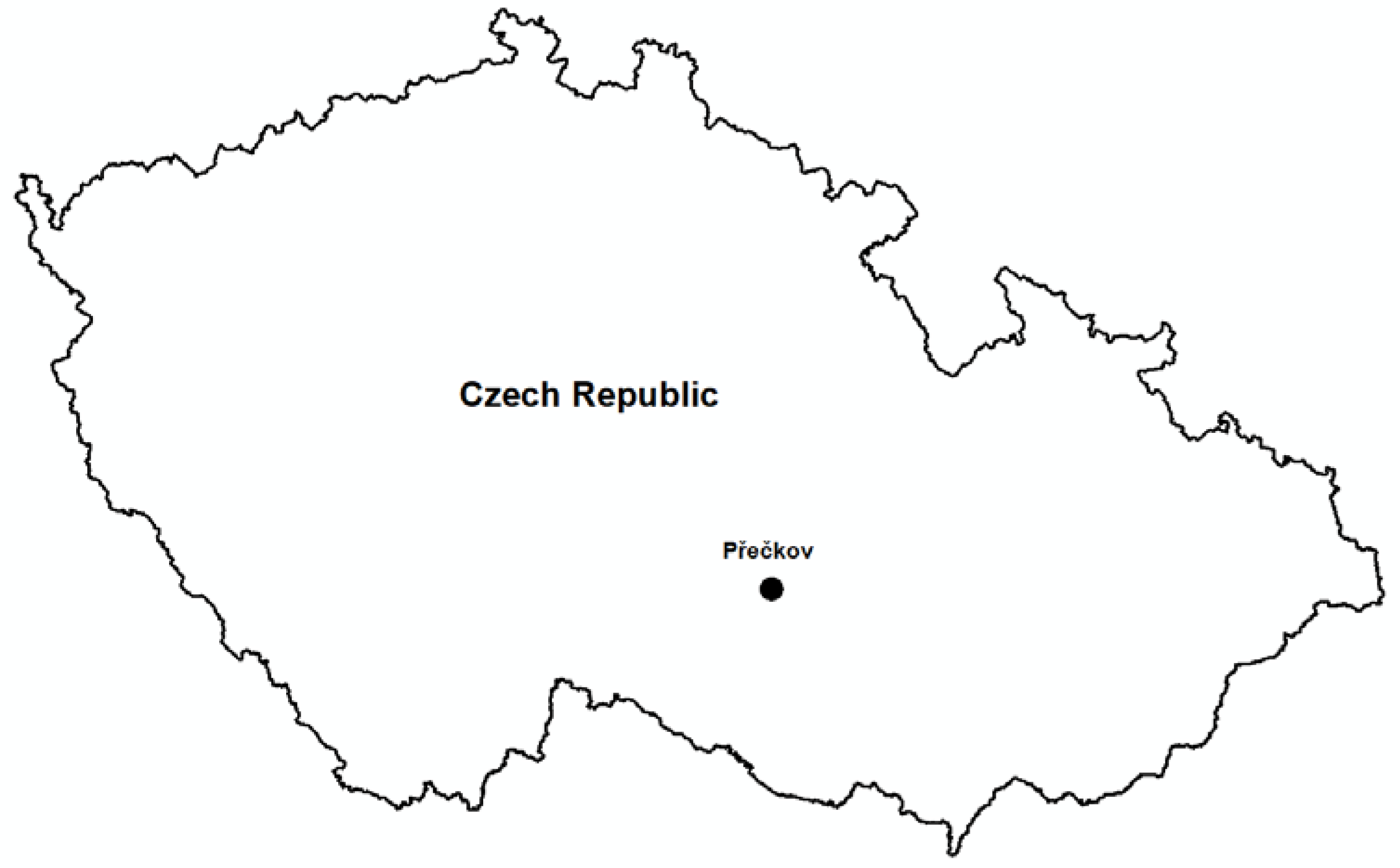
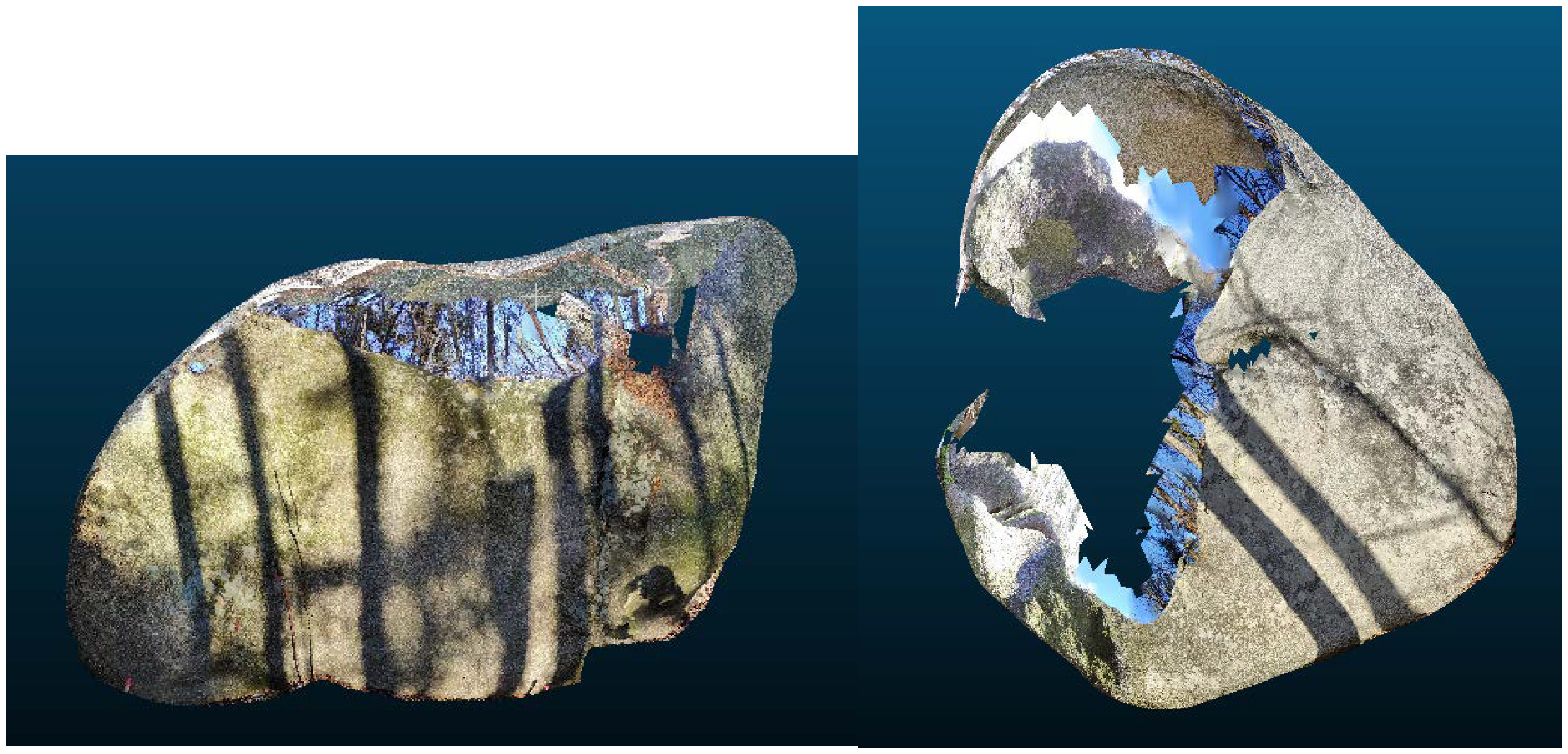
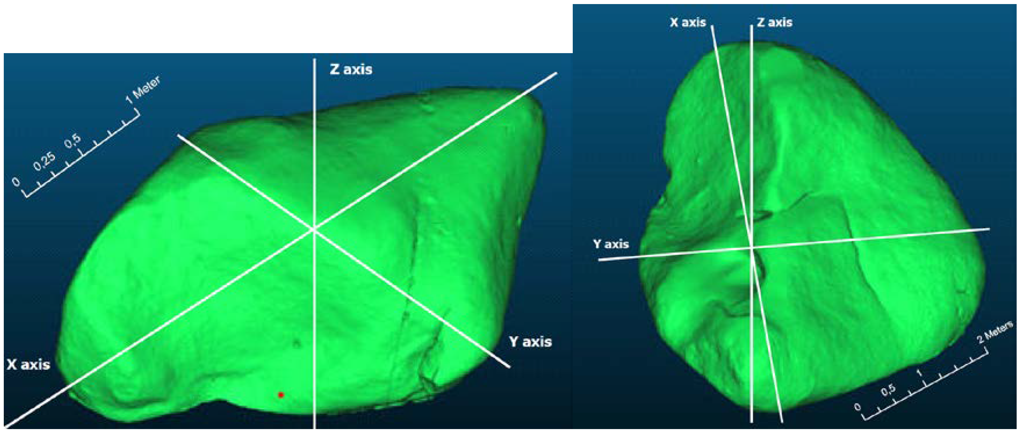
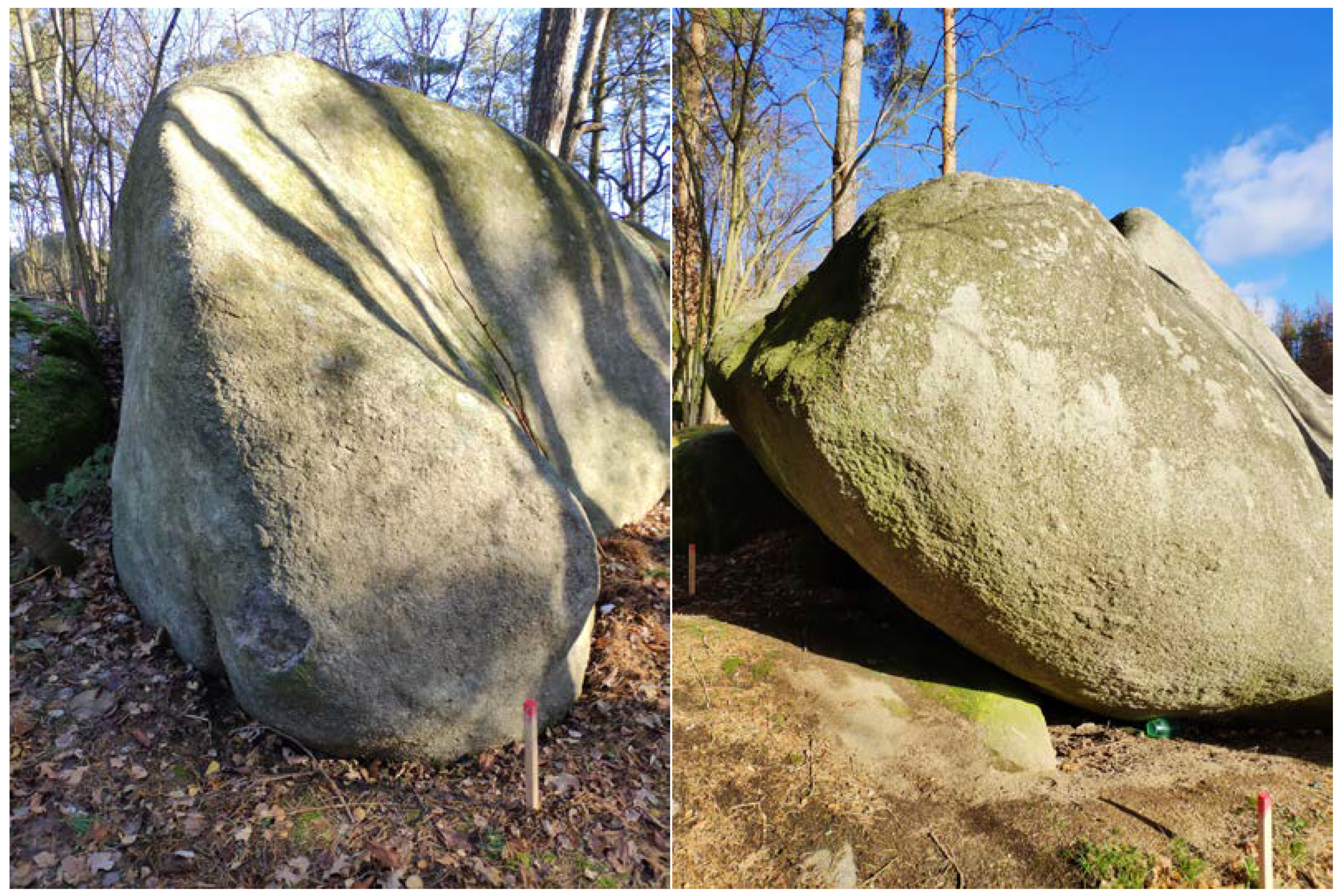
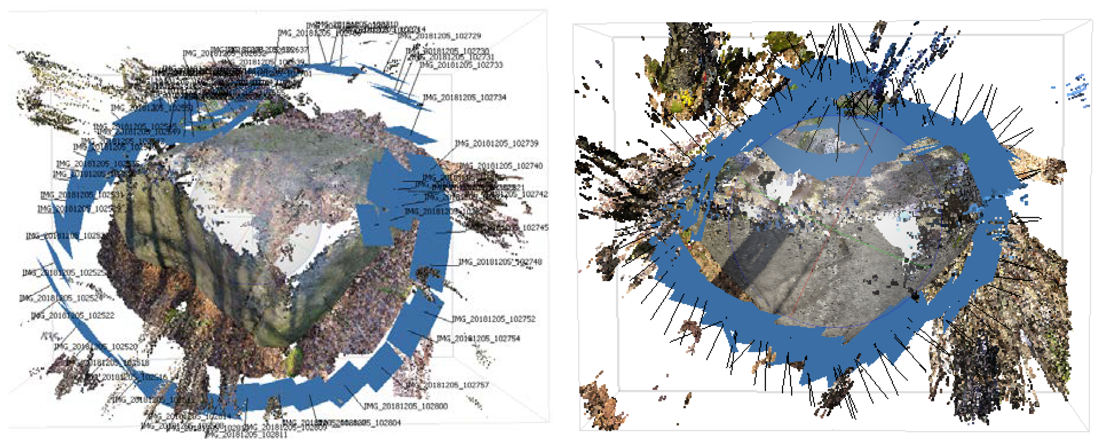
2]. Therefore, the main aim of this research is to compare different remote sensing methods for 3D modeling of small rock outcrops on the example of two boulders and to answer the question whether modern technologies of 3D modeling using modern smartphones can offer a simpler and cheaper method for 3D reconstructions of small rock outcrops and other similar objects in other applications, such as archeology. The results of the study should answer whether smartphone applications can be an alternative to conventional data collection methods such as TLS and close-range photogrammetry with sufficient accuracy without the need of expensive instruments (TLS) or professional SfM software.
4. Discussion and Conclusions
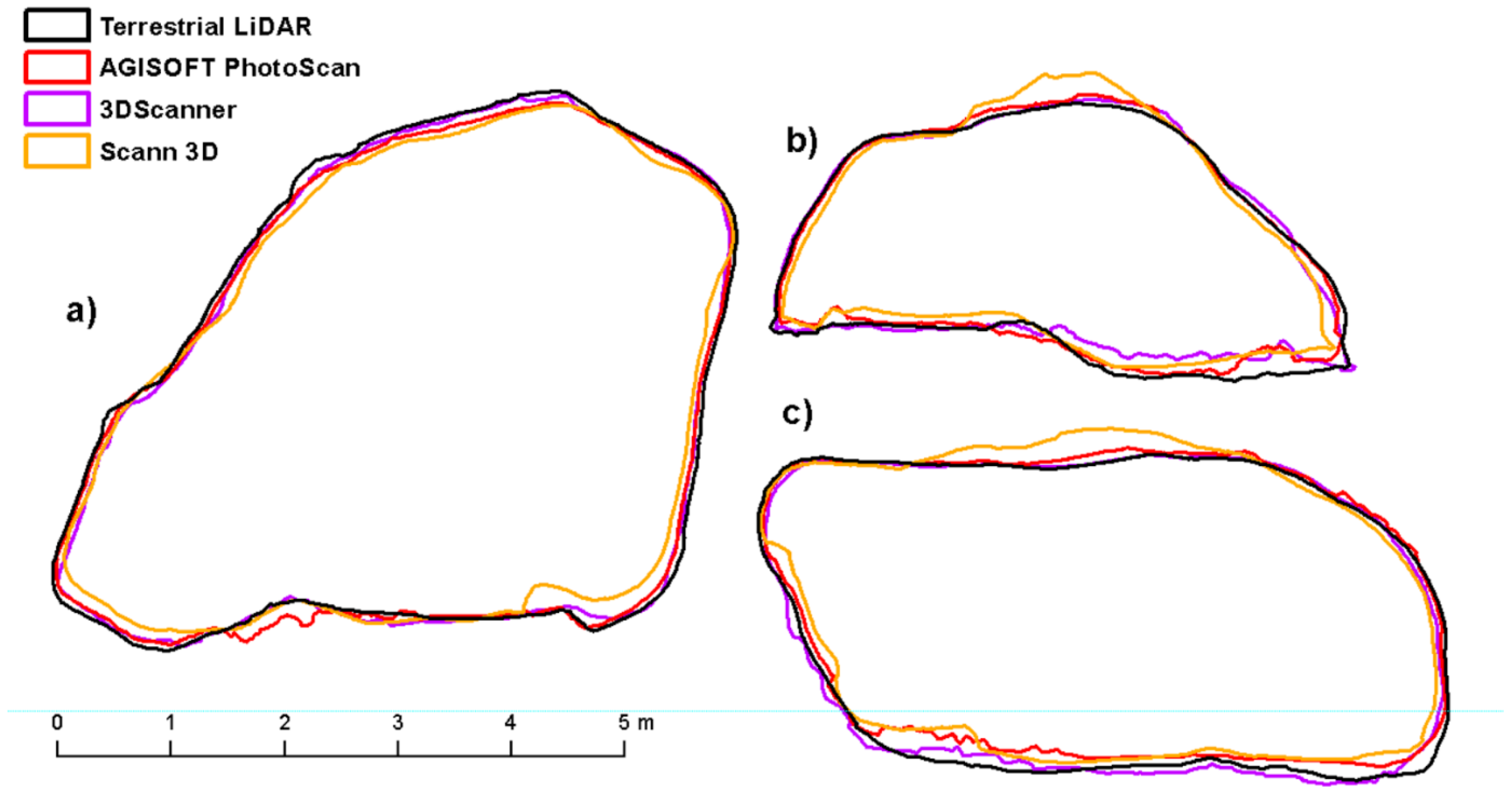
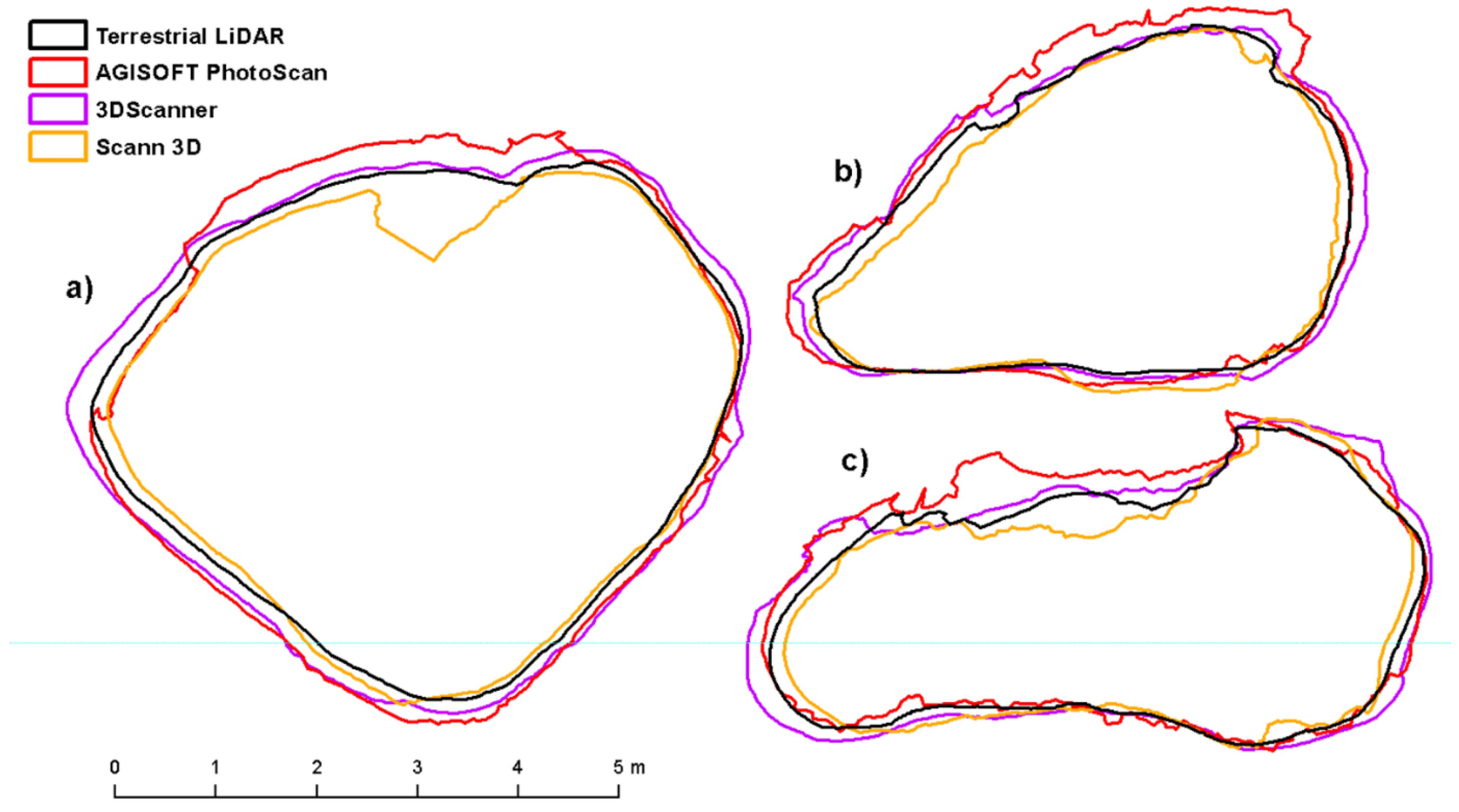
The results of comparison of different remote sensing methods for 3D modeling of small rock outcrops are not entirely clear, and it is not possible to state which mapping method is optimal. Nevertheless, it can be stated that all methods are usable for the purpose of creating rock outcrop models. These surprisingly good results in all image-based methods used are mainly due to the texture of the rocks, as the high texture ensures finding of a high number of tie points. The accuracy of a 3D model depends on the amount of feature points extracted from the captured set of images. If a surface being captured is texture rich, the quality of the produced data would be higher in comparison with poorly textured surfaces. The problem of feature extraction from a texture-less surface is mentioned in many previous studies [
50,
51,
52]. The limiting factors are mainly light conditions during imaging because all methods are passive and are based on the visible part of the electromagnetic spectrum. Good quality model processing is also dependent on the overlay of images, which puts demands during the manual imaging process. In the case of ready-to-use apps like SCANN3D and 3D Scanner for ARCore is process driven by app itself. Compared to TLS, they do not require expensive instruments and achieve very similar results. However, when processing photos in SCANN3D App and AGISOFT PhotoScan, the disadvantage is the necessity to measure at least 3 control points to scale and position in the coordinate system. The 3DScanner for ARCore is the only application that works completely independently, allowing to create a scale model that is directly applicable for further use. Another advantage is the creation of the model in real time, when it is possible to check calculated model during the scanning and fill in the places with the gaps. Ready-to-use applications have limitations primarily in terms of the size of the subject. In the case of rock formations with detailed texture, it is possible to create models of different sized objects, especially depending on accessibility, as these applications require shorter distance to capture feature points. Based on the results presented here, smartphone apps should be restricted to objects with maximum height of 5 m, but the particular constraint is due to the object’s accessibility rather than its size.
Although there is number of 3D scanning applications for smartphones on the market, there are not many studies dealing with the accuracy of the created models of large objects. Similar studies include e.g., [
50], where authors compared cloud processing of images taken with different types of smartphones for the purposes of archeological documentation of buildings with the conclusion that the models created are accurate enough, but there are errors at the edges of the model up to 50 cm. Another study [
51] focused on reliability of smartphones that incorporate 3D depth sensors for 3D reconstruction of cultural heritage objects. The authors used Google Tango technology and compared results with photogrammetry. The results are very similar as [
53], showing the larger deviations on the edges of the model where no perfect match was achieved. The model produced by photogrammetry was of higher quality than the Tango-based one. In [
54] the authors concluded that it is possible to obtain high-quality results from numerous images of building captured by smartphone cameras using appropriate software solutions. Very similar results were gained in [
55], comparison of riverbank models from TLS and close-range photogrammetry resulting in RMSE from 0,02–0,05 m, depending on the device used (digital single-lens camera x smartphone). In [
2] authors tried to create model of the interior of cave by SCANN3D app with conclusion, that due to the higher number of images and to the particularly poor light conditions, the application was able to reconstruct the models only partially, with a quality that was not excellent in terms of the number of points and completeness of the model, even when setting the highest quality level.
Due to the rapid development, in near future, it will be possible to count on further improvements in the 3D data collection using smartphones. In many cases, new smartphones for 2020 already have another (mostly third or fourth) camera for determining the depth of images (ToF cameras—Time of Flight), which should further refine the possibility of creating 3D models according to manufacturer´s information. In [
56] the authors tested the ToF camera system with different objects to check the surface of reconstruction and accuracy evaluation. The results have demonstrated that the proposed technique is feasible for dense 3D measurement applications. In [
57] the authors developed a machine vision system consisting of RGB and ToF camera to estimate the size of apples in tree canopies. With this system, they were able to not only measure the size of apple fruits but even to calculate the local coordinates of each fruit. For example, the 3D Scanner for ARCore app also allows the use of ToF camera in the new version. The disadvantage is the lower resolution of ToF cameras. However, phones for the year 2020 can have up to 5 Mpix ToF cameras and can improve the data acquisition. As a result, smartphones can replace expensive instruments such as Terrestrial Laser Scanners as well as photogrammetric cameras and desktop software for photogrammetric processing.


