Assessment of FSDAF Accuracy on Cotton Yield Estimation Using Different MODIS Products and Landsat Based on the Mixed Degree Index with Different Surroundings


Abstract
:1. Introduction
2. Materials and Methods
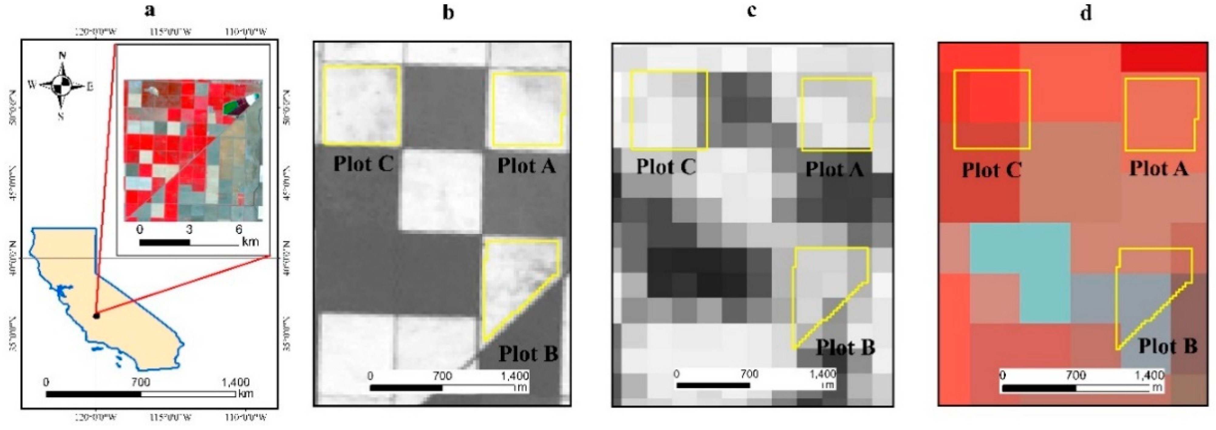
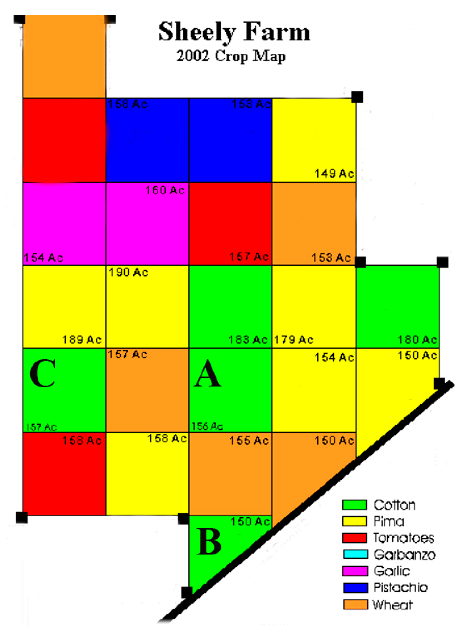
2.1. Study Area
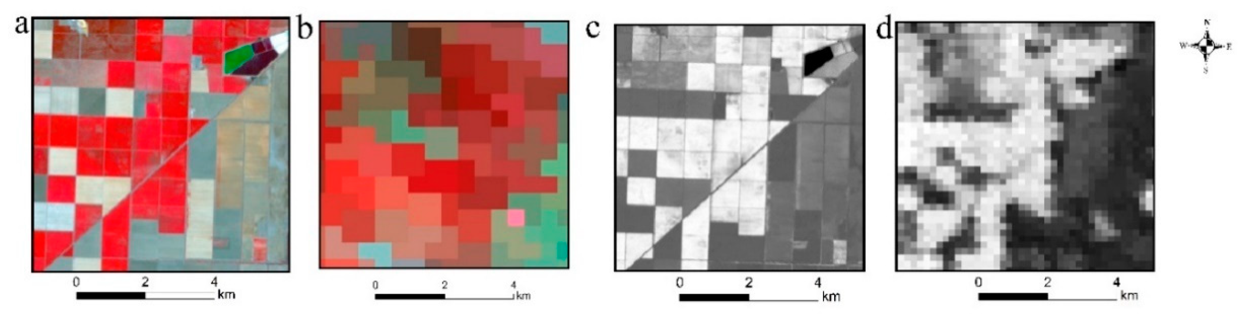
2.2. Satellite Images
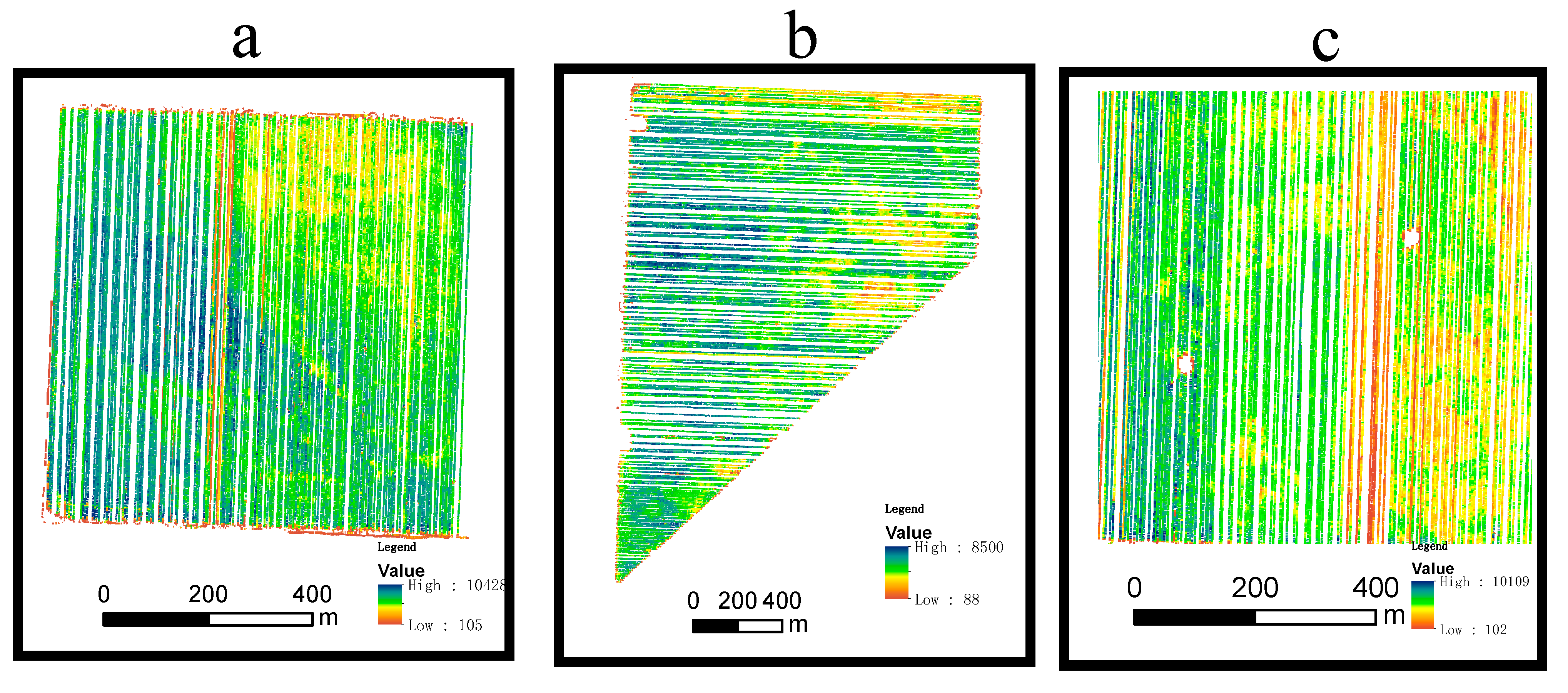
2.3. Yield Data
2.4. FSDAF Model
2.5. Selection of Images for the Fusion Model
2.6. Mixed Degree Index (MDI)
- (1)
- Mixed pixel area ratio (MPAR)
- (2)
- NDVI proportion (NDVIPro)
- (3)
- Mixed degree index (MDI)
2.7. Yield Estimation Model
2.8. Accuracy Evaluation Method
2.9. Flow Chart of Data Analysis, Model Validation, and Evaluation
3. Results
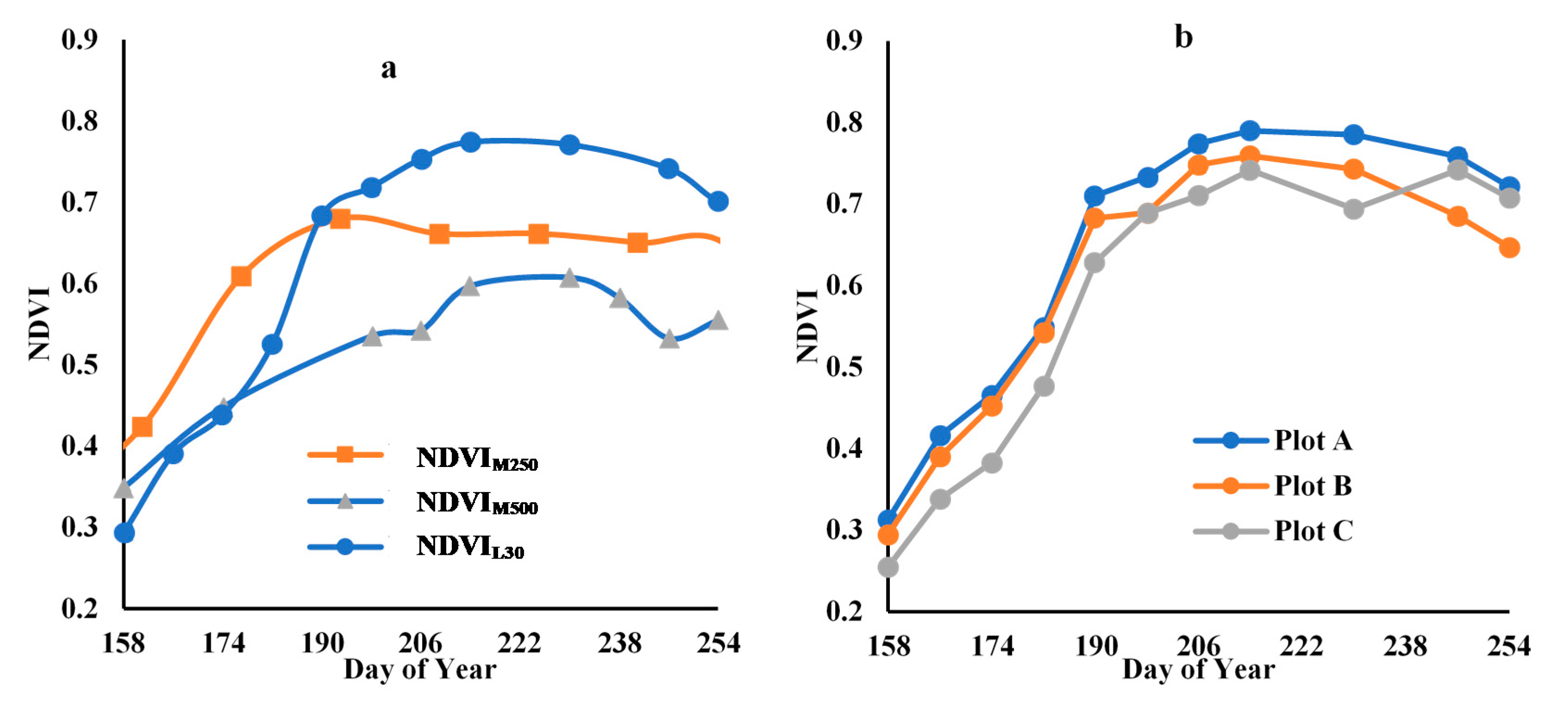
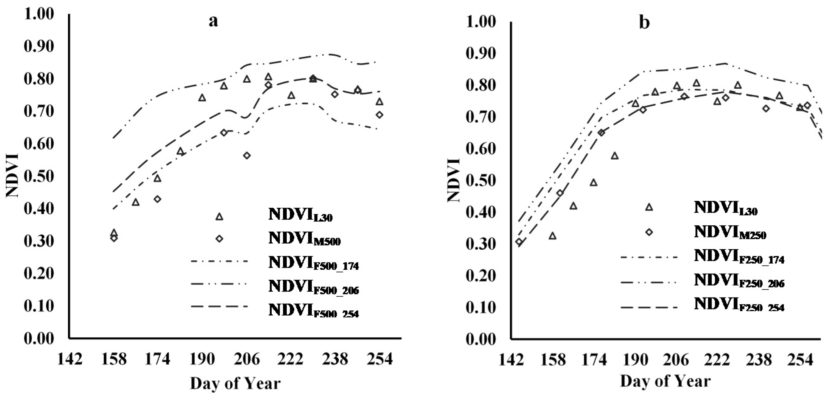
3.1. Time-Series NDVI of the MODIS and Landsat Images
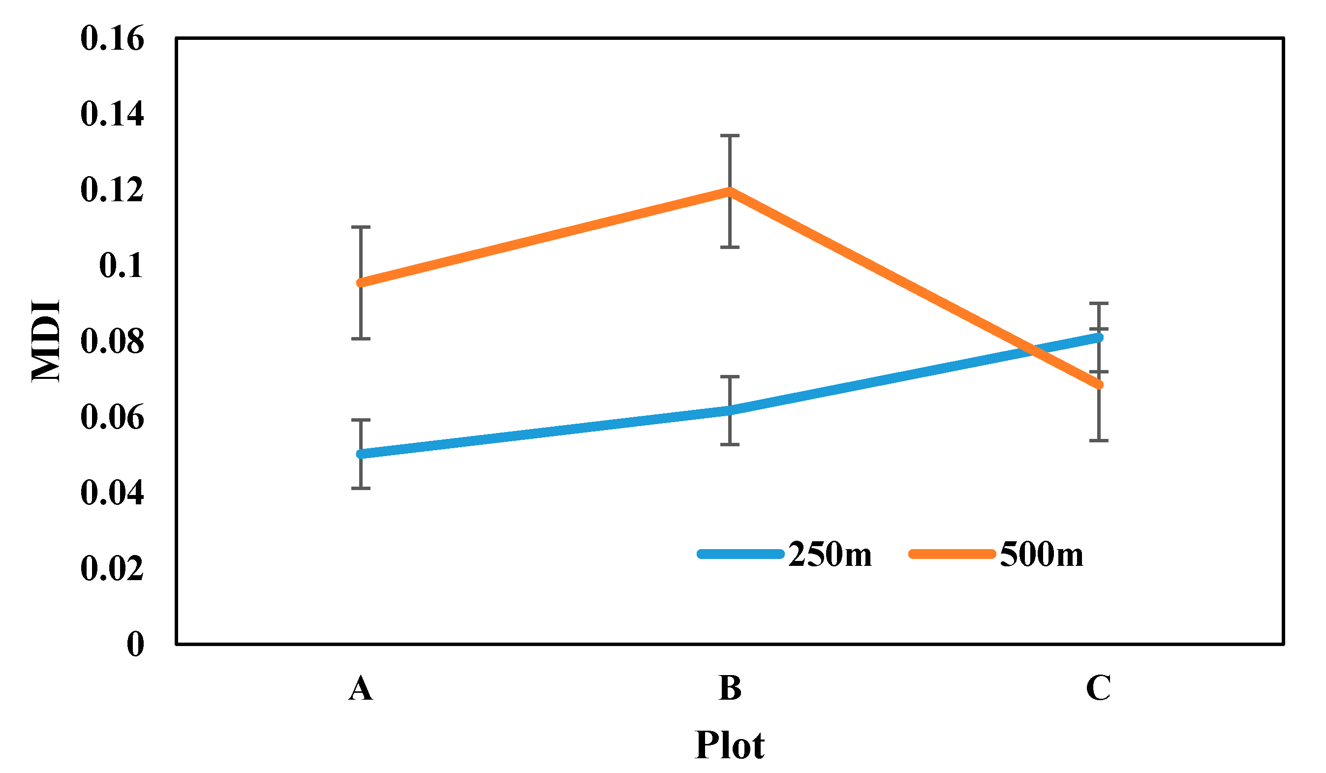
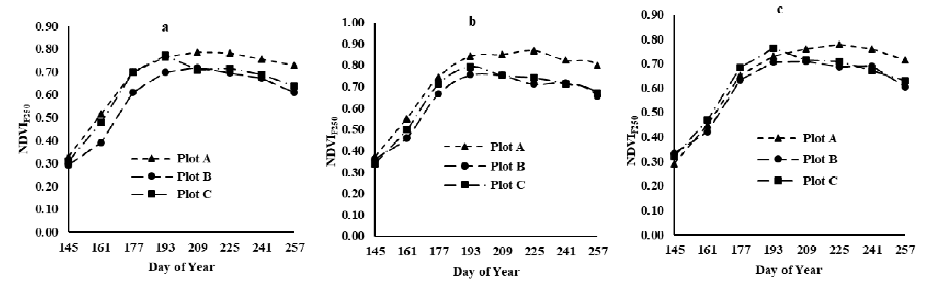
3.2. MDI of A/B/C at Different Spatial Resolutions
3.3. Landsat–MODIS Fusion Results
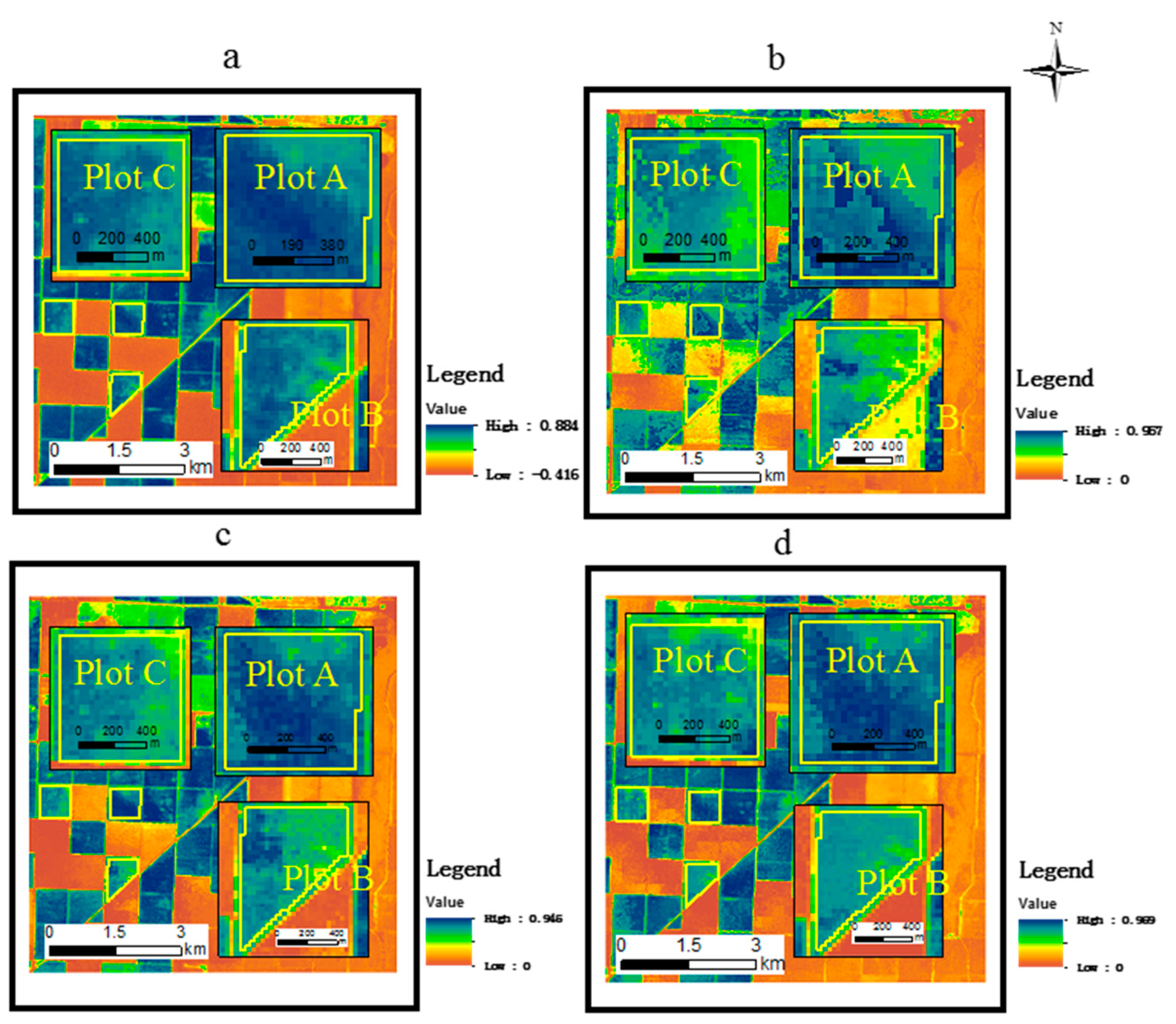
3.3.1. Results of the Fusion of Landsat at Different Reference Dates with 500 m MOD09GA
3.3.2. Results of the Fusion of Landsat at Different Reference Dates with 250 m MOD13Q1
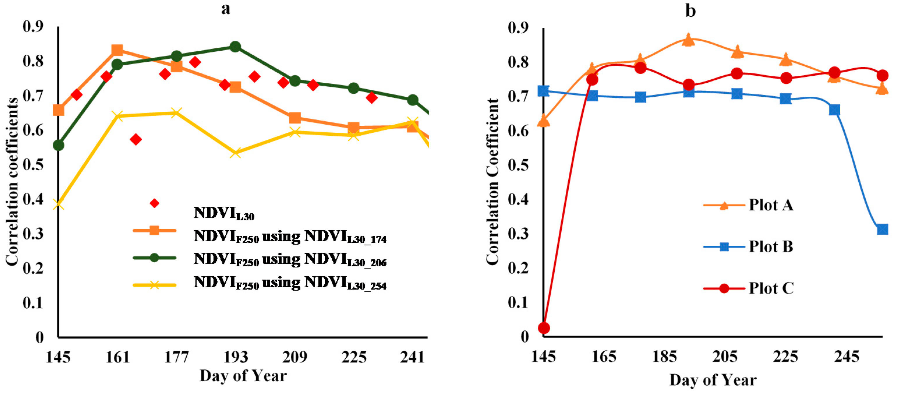
3.3.3. Analysis of Time-Series Fusion Results
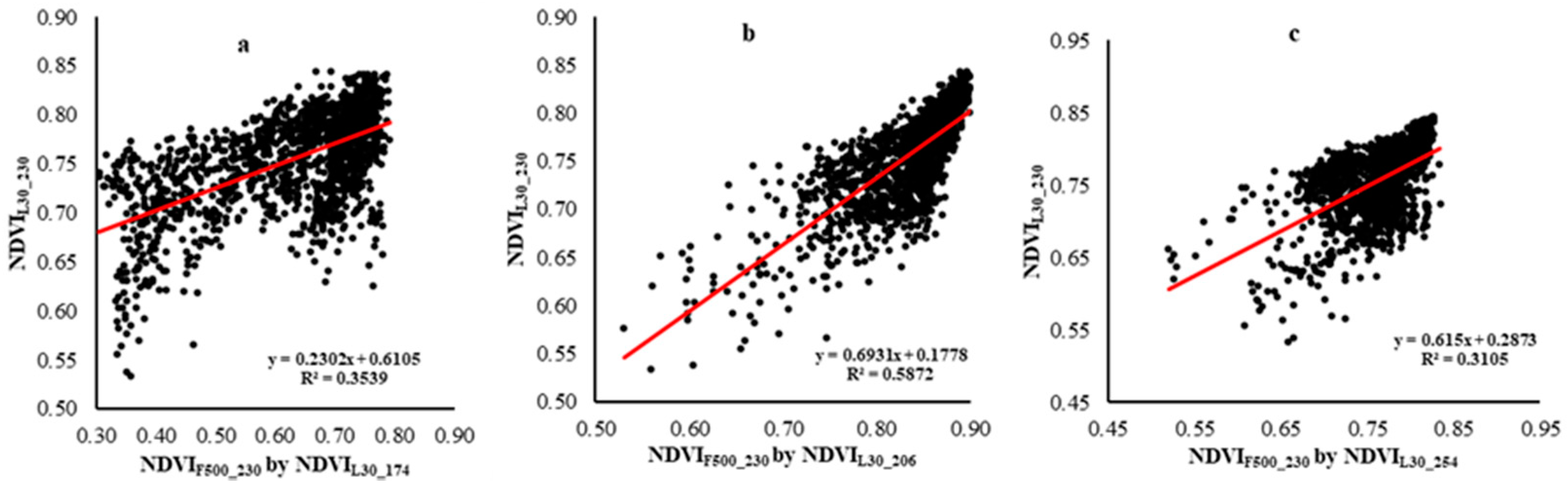
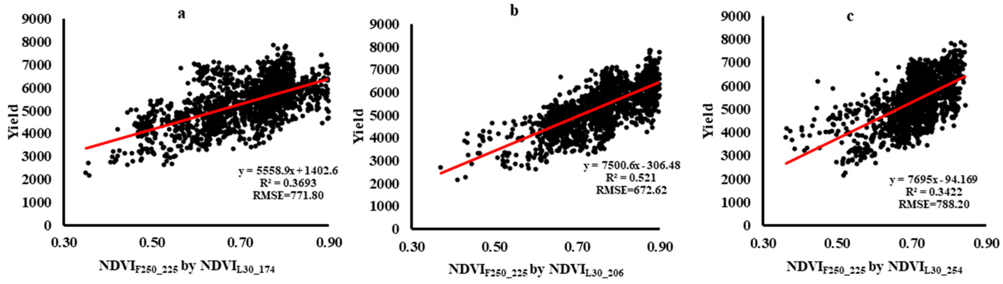
3.4. Correlation Analysis between Cotton Yield and Time-Series Fusion NDVI
4. Discussion
5. Conclusions
Author Contributions
Funding
Acknowledgments
Conflicts of Interest
References
- Shen, M.; Tang, Y.; Chen, J.; Zhu, X.; Zheng, Y. Influences of temperature and precipitation before the growing season on spring phenology in grasslands of the central and eastern Qinghai-Tibetan Plateau. Agric. For. Meteorol. 2011, 151, 1711–1722. [Google Scholar] [CrossRef]
- Shen, M.; Zhang, G.; Cong, N.; Wang, S.; Kong, W.; Piao, S. Increasing altitudinal gradient of spring vegetation phenology during the last decade on the qinghai–tibetan plateau. Agric. For. Meteorol. 2014, 189–190, 71–80. [Google Scholar] [CrossRef]
- Kibret, K.S.; Marohn, C.; Cadisch, G. Assessment of land use and land cover change in South Central Ethiopia during four decades based on integrated analysis of multi-temporal images and geospatial vector data. Remote Sens. Appl. Soc. Environ. 2016, 3, 1–19. [Google Scholar] [CrossRef]
- Ran, Y.; Li, X.; Jin, R.; Kang, J.; Cosh, M.H. Strengths and weaknesses of temporal stability analysis for monitoring and estimating grid-mean soil moisture in a high-intensity irrigated agricultural landscape. Water Resour. Res. 2017, 53, 283–301. [Google Scholar] [CrossRef]
- Nuarsa, I.W.; Nishio, F.; Hongo, C.; Mahardika, I.G. Using variance analysis of multitemporal MODIS images for rice field mapping in Bali Province, Indonesia. Int. J. Remote Sens. 2012, 33, 5402–5417. [Google Scholar] [CrossRef]
- Sakamoto, T.; Gitelson, A.A.; Arkebauer, T.J. MODIS-based corn grain yield estimation model incorporating crop phenology information. Remote Sens. Environ. 2013, 131, 215–231. [Google Scholar] [CrossRef]
- Zhang, Z.; Li, Z.; Chen, Y.; Zhang, L.; Tao, F. Improving regional wheat yields estimations by multi-step-assimilating of a crop model with multi-source data. Agric. For. Meteorol. 2020, 290, 107993. [Google Scholar] [CrossRef]
- Yuhan, R.; Xiaolin, Z.; Jin, C.; Jianmin, W. An improved method for producing high spatial-resolution ndvi time series datasets with multi-temporal modis ndvi data and landsat tm/etm+ images. Remote Sens. 2015, 7, 7865–7891. [Google Scholar]
- Yu, L.; Shi, Y.; Gong, P. Land cover mapping and data availability in critical terrestrial ecoregions: A global perspective with Landsat thematic mapper and enhanced thematic mapper plus data. Biol. Conserv. 2015, 190, 34–42. [Google Scholar] [CrossRef]
- Masek, J.G.; Huang, C.; Wolfe, R.; Cohen, W.; Hall, F.; Kutler, J.; Nelson, P. North american forest disturbance mapped from a decadal landsat record. Remote Sens. Environ. 2008, 112, 2914–2926. [Google Scholar] [CrossRef]
- Main-Knorn, M.; Cohen, W.B.; Kennedy, R.E.; Grodzki, W.; Pflugmacher, D.; Griffiths, P.; Hostert, P. Monitoring coniferous forest biomass change using a Landsat trajectory-based approach. Remote Sens. Environ. 2013, 139, 277–290. [Google Scholar] [CrossRef]
- Cohen, W.B.; Goward, S.N. Landsat’s role in ecological applications of remote sensing. BioScience 2004, 54, 535–545. [Google Scholar] [CrossRef]
- Roy, D.P.; Ju, J.; Lewis, P.; Schaaf, C.; Lindquist, E. Multi-temporal modis-landsat data fusion for relative ra-diometric normalization, gap filling, and prediction of landsat data. Remote Sens. Environ. 2008, 112, 3112–3130. [Google Scholar] [CrossRef]
- González-Sanpedro, M.; Le Toan, T.; Moreno, J.; Kergoat, L.; Rubio, E. Seasonal variations of leaf area index of agricultural fields retrieved from Landsat data. Remote Sens. Environ. 2008, 112, 810–824. [Google Scholar] [CrossRef] [Green Version]
- Minghelli, A.; Chevalier, C.; Descloitres, J.; Berline, L.; Blanc, P.; Chami, M. Synergy between Low Earth Orbit (LEO)—MODIS and Geostationary Earth Orbit (GEO)—GOES Sensors for Sargassum Monitoring in the Atlantic Ocean. Remote. Sens. 2021, 13, 1444. [Google Scholar] [CrossRef]
- Yang, J.J.; Wang, B.Y.; Shi, Y.; Li, P.; Zhang, E.W. A multi-sensors weighted data fusion method based on measurement traversal correction. J. Phys. Conf. Ser. 2021, 1846, 012081. [Google Scholar] [CrossRef]
- Gao, F.; Masek, J.; Schwaller, M.; Hall, F. On the blending of the Landsat and MODIS surface reflectance: Predicting daily Landsat surface reflectance. IEEE Trans. Geosci. Remote Sens. 2006, 44, 2207–2218. [Google Scholar]
- Zhu, X.; Chen, J.; Gao, F.; Chen, X.; Masek, J.G. An enhanced spatial and temporal adaptive reflectance fusion model for complex heterogeneous regions. Remote Sens. Environ. 2010, 114, 2610–2623. [Google Scholar] [CrossRef]
- Hilker, T.; Wulder, M.; Coops, N.; Linke, J.; McDermid, G.; Masek, J.G.; Gao, F.; White, J. A new data fusion model for high spatial- and temporal-resolution mapping of forest disturbance based on Landsat and MODIS. Remote Sens. Environ. 2009, 113, 1613–1627. [Google Scholar] [CrossRef]
- Emelyanova, I.V.; McVicar, T.R.; Van Niel, T.G.; Li, L.T.; Van Dijk, A.I.J.M. Assessing the accuracy of blending Landsat–MODIS surface reflectances in two landscapes with contrasting spatial and temporal dynamics: A framework for algorithm selection. Remote Sens. Environ. 2013, 133, 193–209. [Google Scholar] [CrossRef]
- Zhu, X.; Helmer, E.H.; Gao, F.; Liu, D.S.; Chen, J.; Lefsky, M.A. A flexible spatiotemporal method for fusing satellite images with different resolutions. Remote Sens. Environ. 2016, 172, 165–177. [Google Scholar] [CrossRef]
- Broich, M.; Huete, A.; Tulbure, M.G.; Ma, X.; Xin, Q.; Paget, M.; Restrepo-Coupe, N.; Davies, K.; Devadas, R.; Held, A. Land surface phenological response to decadal climate variability across Australia using satellite remote sensing. Biogeosciences 2014, 11, 5181–5198. [Google Scholar] [CrossRef] [Green Version]
- Ali, S.; Cheema, M.; Waqas, M.; Waseem, M.; Awan, U.; Khaliq, T. Changes in Snow Cover Dynamics over the Indus Basin: Evidences from 2008 to 2018 MODIS NDSI Trends Analysis. Remote Sens. 2020, 12, 2782. [Google Scholar] [CrossRef]
- Xu, Q.; Yang, G.; Long, H.; Wang, L.; Li, X.; Huang, D. Crop information identification based on MODIS NDVI time-series data. Trans. Chin. Soc. Agric. Eng. 2014, 30, 134–144. [Google Scholar]
- Alexandridis, T.; Ovakoglou, G. Relation of MODIS EVI and LAI Across Time, Vegetation Types and Hydrological Regimes. In Proceedings of the EGU General Assembly Conference, Vienna, Austria, 12–17 April 2015. [Google Scholar]
- Liu, J.; Huffman, T.; Qian, B.; Shang, J.; Li, Q.; Dong, T.; Davidson, A.; Jing, Q. Crop yield estimation in the Canadian Prairies using Terra/MODIS-derived crop metrics. IEEE J. Sel. Top. Appl. Earth Obs. Remote Sens. 2020, 1, 99. [Google Scholar] [CrossRef]
- Sakamoto, T. Incorporating environmental variables into a MODIS-based crop yield estimation method for United States corn and soybeans through the use of a random forest regression algorithm. ISPRS J. Photogramm. Remote. Sens. 2020, 160, 208–228. [Google Scholar] [CrossRef]
- Son, N.; Chen, C.; Minh, V.Q.; Trung, N. A comparative analysis of multitemporal MODIS EVI and NDVI data for large-scale rice yield estimation. Agric. For. Meteorol. 2014, 197, 52–64. [Google Scholar] [CrossRef]
- Chipanshi, A.; Zhang, Y.; Kouadio, L.; Newlands, N.; Davidson, A.; Hill, H.; Warren, R.; Qian, B.; Daneshfar, B.; Bedard, F.; et al. Evaluation of the integrated canadian crop yield fore-caster (ICCYF) model for in-season prediction of crop yield across the canadian agricultural landscape. Agric. For. Meteorol. 2015, 206, 137–150. [Google Scholar]
- Franch, B.; Vermote, E.; Becker-Reshef, I.; Claverie, M.; Huang, J.; Zhang, J.; Justice, C.; Sobrino, J.A. Improving the timeliness of winter wheat production forecast in the United States of America, Ukraine and China using MODIS data and NCAR Growing Degree Day information. Remote Sens. Environ. 2015, 161, 131–148. [Google Scholar] [CrossRef]
- Liu, H.; Meng, L.; Zhang, X.; Susan, U.; Ning, D.; Sun, S. Estimation model of cotton yield with time-series Landsat images. Trans. Chin. Soc. Agric. Eng. 2015, 31, 215–220. [Google Scholar]
- Meng, L.; Zhang, X.L.; Liu, H.; Guo, D.; Yan, Y.; Qin, L.; Pan, Y. Estimation of cotton yield using the recon-structed time-series vegetation index of landsat data. Can. J. Remote Sens. 2017, 43, 244–255. [Google Scholar] [CrossRef]
- ZarcoTejada, P.J.; Ustin, S.L.; Whiting, M.L. Temporal and Spatial Relationships between Within-Field Yield Variability in Cotton and High-Spatial Hyperspectral Remote Sensing Imagery. Agron. J. 2005, 97, 641–653. [Google Scholar] [CrossRef] [Green Version]
- Meng, L.; Liu, H.; Zhang, X.; Ren, C.; Ustin, S.; Qiu, Z.; Xu, M.; Guo, D. Assessment of the effectiveness of spatiotemporal fusion of multi-source satellite images for cotton yield estimation. Comput. Electron. Agric. 2019, 162, 44–52. [Google Scholar] [CrossRef]
- Bookstein, F.L. Shape and the information in medical images: A decade of the morphometric synthesis. In Workshop on Mathematical Methods in Biomedical Image Analysis; IEEE: San Francisco, CA, USA, 1997. [Google Scholar]
- Rojas, O. Operational maize yield model development and validation based on remote sensing and agrometeorological data in Kenya. Int. J. Remote Sens. 2007, 28, 3775–3793. [Google Scholar] [CrossRef] [Green Version]
- Dehghani, R.; Ghorbani, M.A.; Teshnehlab, M.; Rikhtehgar, G.A.; Asadi, E. Comparison and evalution of bayesian neural network, gene gramming, support vector machine and multiple expression proLinear regression in river discharge estimation (Case Study: Sufi Chay Basin). Iran. Irrig. & Water Eng. 2015, 5, 66–85. [Google Scholar]
- Fitzgerald, G.J.; Pinter, P.J., Jr.; Hunsaker, D.J.; Clarke, T.R. Multiple shadow fractions in spectral mixture analysis of a cotton canopy. Remote Sens. Environ. 2005, 97, 526–539. [Google Scholar] [CrossRef]
- Chen, J.; Jnsson, P.M. A simple Method for Reconstructing a High Quality NDVI Time-series Data Set Based on the Savitzky-Golay Filter. Remote Sens. Environ. 2004, 91, 332. [Google Scholar] [CrossRef]
- Jamshidi, S.; Zand-Parsa, S.; Jahromi, M.N.; Niyogi, D. Application of A Simple Landsat-MODIS Fusion Model to Estimate Evapotranspiration over A Heterogeneous Sparse Vegetation Region. Remote Sens. 2019, 11, 741. [Google Scholar] [CrossRef] [Green Version]
- Sakamoto, T.; Yokozawa, M.; Toritani, H.; Shibayama, M.; Ishitsuka, N.; Ohno, H. A crop phenology detection method using time-series modis data. Remote Sens. Environ. 2005, 96, 366–374. [Google Scholar] [CrossRef]
- Zhou, X.; Wang, P.; Tansey, K.; Zhang, S.; Wang, L. Developing a fused vegetation temperature condition index for drought monitoring at field scales using sentinel-2 and modis imagery. Comput. Electron. Agric. 2020, 168, 105144. [Google Scholar] [CrossRef]


| Product | Sensors | Date | Number of Images |
|---|---|---|---|
| Landsat | TM 5 | 6 May; 22 May; 7 June; 23 June; 1 July; 17 July; 2 August; 26 August; 11 September; 27 September; 13 October; 29 October; | 12 |
| ETM 7 | 14 May; 30 May; 15 June; 9 July; 25 July; 18 August; 3 September; 19 September; 5 October; 21 October; | 10 | |
| MODIS | MOD13Q1 | 25 May; 10 June; 26 June; 12 July; 28 July; 13 August; 29 August; 14 September; | 8 |
| MOD09GA | 7 June; 23 June; 17 July; 25 July; 2 August; 18 August; 26 August; 3 September; 11 September; | 9 |
| Plot | Early Stage (NDVIL30_174) | Middle Stage (NDVIL30_206) | End Stage (NDVIL30_254) |
|---|---|---|---|
| A | y = 0.3225x + 0.5601 R² = 0.3298 | y = 1.5028x − 0.5154 R² = 0.6586 | y = 0.8208x + 0.1313 R² = 0.1401 |
| B | y = 0.2752x + 0.5978 R² = 0.3775 | y = 0.6046x + 0.2604 R² = 0.652 | y = 0.5426x + 0.3506 R² = 0.2626 |
| C | y = 0.2282x + 0.5908 R² = 0.3962 | y = 0.8174x + 0.0569 R² = 0.6599 | y = 1.092x − 0.0946 R² = 0.4449 |
| ABC | y = 0.2302x + 0.6105 R² = 0.3539 | y = 0.6931x + 0.1778 R² = 0.5872 | y = 0.615x + 0.2873 R² = 0.3105 |
| Plot | Early Stage | Middle Stage | End Stage |
|---|---|---|---|
| A | y = 0.3669x + 0.5008 R² = 0.4933 | y = 0.6458x + 0.2429 R² = 0.831 | y = 0.6934x + 0.253 R² = 0.6195 |
| B | y = 0.3911x + 0.4802 R² = 0.6298 | y = 0.4805x + 0.4025 R² = 0.6082 | y = 0.9684x + 0.0901 R² = 0.7703 |
| C | y = 0.224x + 0.5886 R² = 0.3148 | y = 0.4911x + 0.389 R² = 0.800 | y = 0.3436x + 0.5077 R² = 0.4459 |
| ABC | y = 0.3371x + 0.5166 R² = 0.5372 | y = 0.4492x + 0.4173 R² = 0.739 | y = 0.5085x + 0.3962 R² = 0.5911 |
Publisher’s Note: MDPI stays neutral with regard to jurisdictional claims in published maps and institutional affiliations. |
© 2021 by the authors. Licensee MDPI, Basel, Switzerland. This article is an open access article distributed under the terms and conditions of the Creative Commons Attribution (CC BY) license (https://creativecommons.org/licenses/by/4.0/).
Share and Cite
Meng, L.; Liu, H.; Ustin, S.L.; Zhang, X. Assessment of FSDAF Accuracy on Cotton Yield Estimation Using Different MODIS Products and Landsat Based on the Mixed Degree Index with Different Surroundings. Sensors 2021, 21, 5184. https://doi.org/10.3390/s21155184
Meng L, Liu H, Ustin SL, Zhang X. Assessment of FSDAF Accuracy on Cotton Yield Estimation Using Different MODIS Products and Landsat Based on the Mixed Degree Index with Different Surroundings. Sensors. 2021; 21(15):5184. https://doi.org/10.3390/s21155184
Chicago/Turabian StyleMeng, Linghua, Huanjun Liu, Susan L. Ustin, and Xinle Zhang. 2021. "Assessment of FSDAF Accuracy on Cotton Yield Estimation Using Different MODIS Products and Landsat Based on the Mixed Degree Index with Different Surroundings" Sensors 21, no. 15: 5184. https://doi.org/10.3390/s21155184
APA StyleMeng, L., Liu, H., Ustin, S. L., & Zhang, X. (2021). Assessment of FSDAF Accuracy on Cotton Yield Estimation Using Different MODIS Products and Landsat Based on the Mixed Degree Index with Different Surroundings. Sensors, 21(15), 5184. https://doi.org/10.3390/s21155184