Non-Contact Diagnostics of the Geometry of a Historic Wooden Building as an Element of Periodic Safety Assessment
Abstract
:1. Introduction
2. Materials and Methods
2.1. Description of the Examined Church
2.2. Methods
- Diagnostics by a non-contact method (laser scanning);
- Building a 3D model;
- Selecting structural elements for which the current geometry is determined, and checking whether there are any deviations from the theoretical state;
- If these deviations cannot be found, there are no premises confirming the hypothesis about object deformation under the influence of certain factors—the reasons are reclassified;
2.2.1. Geodetic Measurements
y = d × cosβ × sinα
z = d × sinβ
2.2.2. The Use of TLS Technology in the Church
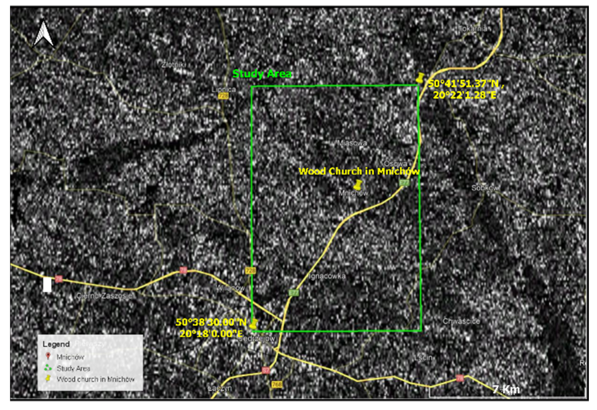
2.2.3. Interferometric Method
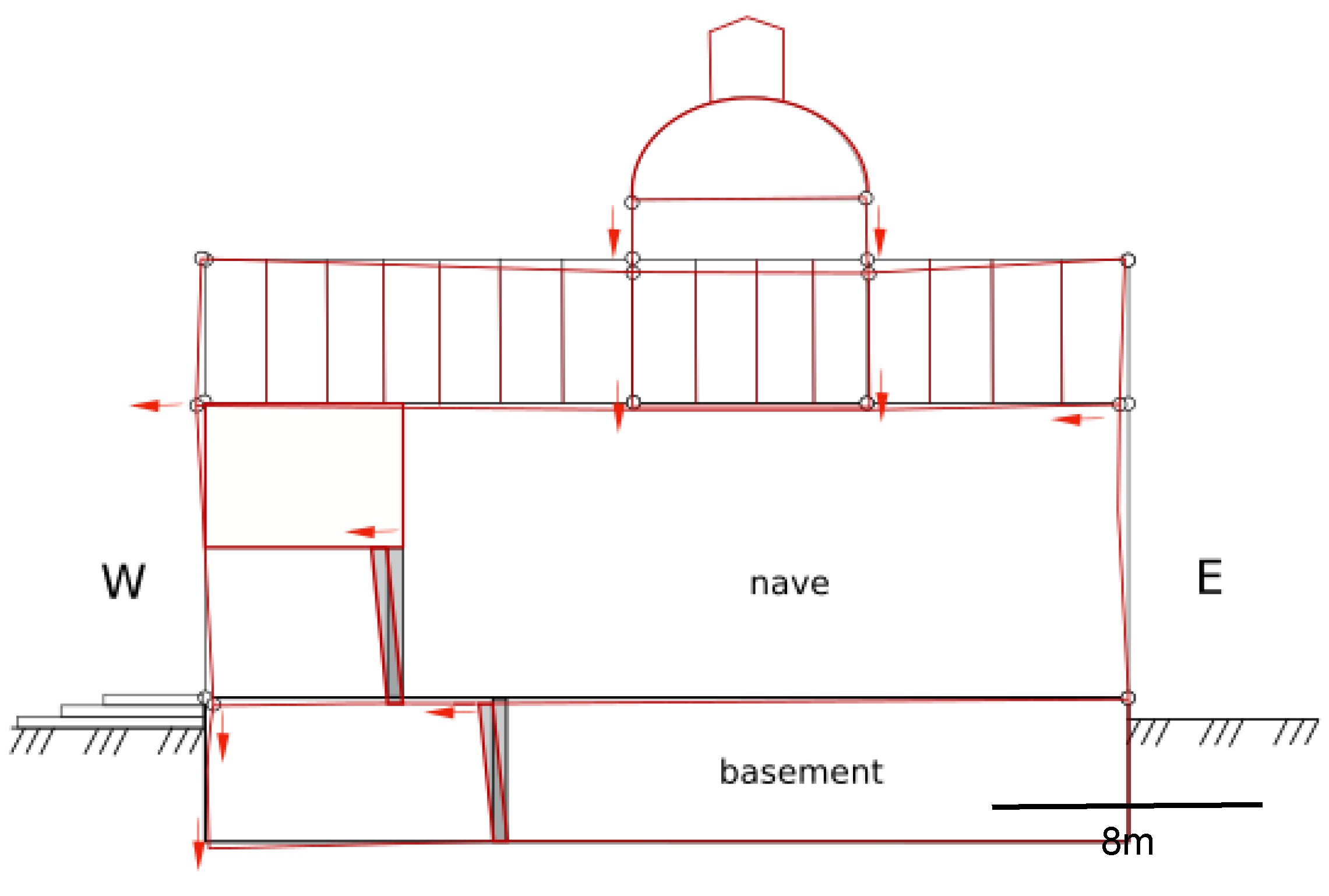
2.2.4. Finite Element Method Analysis
3. Results
3.1. Church Measurements
3.2. Analysis of the Geometric State
3.3. PSInSAR Analysis
3.4. FEM Analysis
4. Discussion
5. Conclusions
Funding
Institutional Review Board Statement
Informed Consent Statement
Data Availability Statement
Acknowledgments
Conflicts of Interest
References
- Ikeda, K.; Murota, K. Critical initial imperfection of structures. Int. J. Solids Struct. 1990, 26, 865–886. [Google Scholar]
- Hutton, D.V. Fundamentals of Finite Element Analysis; McGraw-Hill: New York, NY, USA, 2004. [Google Scholar]
- Holzer, S.; Loferski, J.; Dillard, D. A Review of Creep in Wood: Concepts Relevant to Develop Long-Term Behavior Predictions for Wood Structures. Wood Fiber Sci. 1989, 21, 376–392. [Google Scholar]
- Breyer, D.E.; Cobeen, K.E.; Fridley, K.J.; Pollock, D.G. Design of Wood Structures—ASD/LRFD; McGraw-Hill Education: New York, NY, USA, 2015. [Google Scholar]
- Tsakiri, M.; Lichti, D.; Pfeifer, N. Terrestrial Laser Scanning for Deformation Monitoring. In Proceedings of the 3rd IAG/12th FIG Symposium, Baden, Germany, 22–24 May 2006. [Google Scholar]
- Kurzątkowski, M. Mały Słownik Ochrony Zabytków. (Little Dictionary of Monument Protection); Warszawa MKiS: Warsaw, Poland, 1989. [Google Scholar]
- Falkowski, P.; Uchański, J.; Sörensen, L. The Problem of Standardization of Terrestrial Laser Scanning Techniques for Architecture Inventory Purposes. Arch. Photogramm. Cartogr. Remote Sens. 2008, 18, 633–641. [Google Scholar]
- Davis, A.; Belton, D.; Helmholz, P.; Bourke, P.; McDonald, J. Pilbara rock art: Laser scanning, photogrammetry and 3D photographic reconstruction as heritage management tools. Herit. Sci. 2017, 5, 25. [Google Scholar] [CrossRef] [Green Version]
- Liu, R.; Shi, G.; Ji, F. Ancient architecture reconstructing based on Terrestrial 3D Laser Scanning technology. In Proceedings of the 2nd International Conference on Software Engineering and Data Mining, Chengdu, China, 23–25 June 2010; pp. 285–288. [Google Scholar]
- Rui, X.; Xiaojun, C.; Hongfei, Z. Terrestrial Laser Scanning for the digital protection of historical architecture. In Proceedings of the Second IITA International Conference on Geoscience and Remote Sensing, Qingdao, China, 28–31 August 2010; pp. 246–249. [Google Scholar] [CrossRef]
- Yin, Y.; Antonio, J. Application of 3D laser scanning technology for image data processing in the protection of ancient building sites through deep learning. Image Vis. Comput. 2020, 102, 103969. [Google Scholar] [CrossRef]
- Bai, C.; Wang, Q. Misapplications of 3D laser scanning in metric survey of historic buildings. In Proceedings of the International Conference on Remote Sensing, Environment and Transportation Engineering, Nanjing, China, 24–26 June 2011; pp. 1354–1357. [Google Scholar] [CrossRef]
- Zhang, R.; Wang, Y.; Song, D. Research on 3D Reconstruction Using Laser Scanning Data Acquired from Ancient Architecture. In Proceedings of the First International Conference on Information Science and Engineering, Nanjing, China, 26–28 December 2009; pp. 2145–2148. [Google Scholar] [CrossRef]
- Webb, N.; Buchanan, A. Tracing the Past: A digital analysis of the Lady Chapel vaults at Ely cathedral. In Proceedings of the 3rd Digital Heritage International Congress (DigitalHERITAGE) Held Jointly with 2018 24th International Conference on Virtual Systems & Multimedia (VSMM 2018), San Francisco, CA, USA, 26–30 October 2018; pp. 1–4. [Google Scholar] [CrossRef]
- Barba, S.; De Feo, E.; D’Auria, S.; Guerriero, L. Survey and virtual restoration: The Castle of Magacela (Spain). In Proceedings of the 18th International Conference on Virtual Systems and Multimedia, Milan, Italy, 2–5 September 2012; pp. 641–644. [Google Scholar] [CrossRef]
- Pattee, A.; Höfle, B.; Seitz, C. Integrative 3D recording methods of historic architecture Burg Hohenecken castle from southwest Germany. In Proceedings of the Digital Heritage International Congress (DigitalHeritage), Granada, Spain, 28 September–2 October 2015; pp. 95–98. [Google Scholar] [CrossRef]
- Spring, A.P.; Peters, C.; Minns, T. Using Mid-Range Laser Scanners to Digitize Cultural-Heritage Sites. IEEE Comput. Graph. Appl. 2010, 30, 15–19. [Google Scholar] [CrossRef]
- Guidi, G.; Russo, M.; Angheleddu, D.; Zolese, P. A virtual connection between past and present: The digital revival of Cham’s Architecture (Vietnam). In Proceedings of the 18th International Conference on Virtual Systems and Multimedia, Milan, Italy, 2–5 September 2012; pp. 361–368. [Google Scholar] [CrossRef]
- Hess, M.; Petrovic, V.; Meyer, D.; Rissolo, D.; Kuester, F. Fusion of multimodal three-dimensional data for comprehensive digital documentation of cultural heritage sites. In Proceedings of the Digital Heritage International Congress (DigitalHeritage), Granada, Spain, 28 September–2 October 2015; pp. 595–602. [Google Scholar] [CrossRef]
- Shi, Y.; Cheng, X. Study of architecture modeling method and accuracy based on laser scanning. In Proceedings of the International Conference on Computer Application and System Modeling (ICCASM 2010), Taiyuan, China, 22–24 October 2010; pp. V11-176–V11-180. [Google Scholar] [CrossRef]
- Ghazali, R.; Sukri, A.E.E.; Latif, A.R.A.; Rasam, A.R.A.; Latif, Z.A.; Samad, A.M. Evaluating the relationship between scanning resolution of laser scanner with the accuracy of the 3D model constructed. In Proceedings of the IEEE International Conference on Control System, Computing and Engineering, Penang, Malaysia, 25–27 November 2011; pp. 590–595. [Google Scholar] [CrossRef]
- Rebolj, D.; Pučko, Z.; Babič, N.Č.; Bizjak, M.; Mongus, D. Point cloud quality requirements for Scan-vs-BIM based automated construction progress monitoring. Autom. Constr. 2017, 84, 323–334. [Google Scholar] [CrossRef]
- Sanhudo, L.; Ramos, N.M.M.; Martins, J.P.; Almeida, R.M.S.F.; Barreira, E.; Simões, M.L.; Cardoso, V. A framework for in-situ geometric data acquisition using laser scanning for BIM modelling. J. Build. Eng. 2020, 28, 101073. [Google Scholar] [CrossRef]
- Wojtkowska, M.; Kędzierski, M.; Delis, P. Validation of terrestrial laser scanning and artificial intelligence for measuring deformations of cultural heritage structures. Measurement 2021, 167, 108291. [Google Scholar] [CrossRef]
- Yajing, D.; Chengjun, B. Application scope of the Terrestrial Laser Scanner in measured survey on architectural heritages. In Proceedings of the International Conference on Electric Technology and Civil Engineering (ICETCE), Lushan, China, 22–24 April 2011; pp. 2954–2957. [Google Scholar] [CrossRef]
- Galli, M.; Inglese, C.; Ismaelli, T.; Griffo, M. Rome under Rome: Survey and analysis of the east excavation area beneath the Basilica Iulia. In Proceedings of the 3rd Digital Heritage International Congress (DigitalHERITAGE) Held Jointly with 2018 24th International Conference on Virtual Systems & Multimedia (VSMM 2018), San Francisco, CA, USA, 26–30 October 2018; pp. 1–4. [Google Scholar] [CrossRef]
- Kwoczyńska, B.; Piech, I.; Polewany, P.; Gora, K. Modeling of Sacral Objects Made on the Basis of Aerial and Terrestrial Laser Scanning. In Proceedings of the Baltic Geodetic Congress (BGC Geomatics), Olsztyn, Poland, 21–23 June 2018; pp. 275–282. [Google Scholar] [CrossRef]
- Wang, C.; Wen, C.; Dai, Y.; Yu, S.; Liu, M. Urban 3D modeling with mobile laser scanning: A review. Virtual Real. Intell. Hardw. 2020, 2, 175–212. [Google Scholar] [CrossRef]
- Valenti, G.M.; Romor, J. Image Based Modeling, 3D Laser scan & Gigapixel survey for the documentation of Carlo Lucangeli’s Flavian Amphitheater wooden model. In Proceedings of the 3rd Digital Heritage International Congress (DigitalHERITAGE) Held Jointly with 2018 24th International Conference on Virtual Systems & Multimedia (VSMM 2018), San Francisco, CA, USA, 26–30 October 2018; pp. 1–4. [Google Scholar] [CrossRef]
- Carpiceci, M.; Angelini, A. Looking for the full scan: S. Zenone chapel. In Proceedings of the Metrology for Archaeology and Cultural Heritage (MetroArchaeo), Cassino, FR, Italy, 22–24 October 2018; pp. 345–350. [Google Scholar] [CrossRef]
- Cosentino, A.; Sgarlata, M.; Scandurra, C.; Stout, S.; Galizia, M.; Santagati, C. Multidisciplinary investigations on the byzantine oratory of the Catacombs of Saint Lucia in Syracuse. In Proceedings of the Digital Heritage International Congress (DigitalHeritage), Granada, Spain, 28 September–2 October 2015; pp. 137–140. [Google Scholar] [CrossRef]
- Agnello, F. The Cathedral of Palermo: From survey to historic interpretation. In Proceedings of the Digital Heritage International Congress (DigitalHeritage), Marseille, France, 28 October–1 November 2013; pp. 713–716. [Google Scholar] [CrossRef]
- Huber, D.; Akinci, B.; Tang, P.; Adan, A.; Okorn, B.; Xiong, X. Using laser scanners for modeling and analysis in architecture, engineering, and construction. In Proceedings of the 44th Annual Conference on Information Sciences and Systems (CISS), Princeton, NJ, USA, 17–19 March 2010; pp. 1–6. [Google Scholar] [CrossRef]
- Laing, R.; Leon, M.; Isaacs, J. Monuments Visualization: From 3D Scanned Data to a Holistic approach, an Application to the City of Aberdeen. In Proceedings of the 19th International Conference on Information Visualisation, Barcelona, Spain, 22–24 July 2015; pp. 512–517. [Google Scholar] [CrossRef]
- Cardaci, A.; Roberti, G.M.; Versaci, A. Palazzo Raimondi in Cremona: 3D survey and diagnostic tests for the knowledge of construction techniques and historical materials. In Proceedings of the Digital Heritage International Congress (DigitalHeritage), Granada, Spain, 28 September–2 October 2015; pp. 181–184. [Google Scholar] [CrossRef]
- Tang, P.; Huber, D.; Akinci, B.; Lipman, R.; Lytle, A. Automatic reconstruction of as-built building information models from laser-scanned point clouds: A review of related techniques. Autom. Constr. 2010, 19, 829–843. [Google Scholar] [CrossRef]
- Akib, W.A.A.W.M.; Tahar, K.N.; Ahmad, A. Slope gradient analysis at different resolution using terrestrial laser scanner. In Proceedings of the IEEE 8th International Colloquium on Signal Processing and Its Applications, Melaka, Malaysia, 23–25 March 2012; pp. 169–173. [Google Scholar] [CrossRef] [Green Version]
- Yang, H.; Xu, X.; Xu, W.; Neumann, I. Terrestrial Laser Scanning-Based Deformation Analysis for Arch and Beam Structures. IEEE Sens. J. 2017, 17, 4605–4611. [Google Scholar] [CrossRef]
- Lipecki, T.; Ligarska, H.; Zawadzka, M. The influence of mining activities on the Church of St. Cross in Bytom-Miechowice. Rep. Geod. Geoinform. 2018, 105, 7–18. [Google Scholar] [CrossRef] [Green Version]
- Mirowski, R. Drewniane Kościoły i Dzwonnice Ziemi Świętokrzyskiej. (Wooden Churches and Bell Towers of the Świętokrzyskie Region); Regional Center for Studies and Cultural Environment Protection in Kielce: Kielce, Poland, 2002. [Google Scholar]
- Jaskłowski, W. Z Przeszłości Jędrzejowskiego. Dominium Mnichów. (From the Past of Jędrzejowski. Dominion of Mnichow); Mnichów: Jedrzejow, Poland, 1919. [Google Scholar]
- Wiśniewski, J. Historyczny Opis Kościołów, Miast, Zabytków i Pamiątek Jędrzejowskich. (Historical Description of Jędrzejów Churches, Towns, Monuments and Mementoes); School of Rzem: Marjówka, Poland, 1930. [Google Scholar]
- Tkaczyk, P. Kościół Świętego Szczepana w Mnichowie, Zabytek Drewnianej Architektury Sakralnej. (Saint Stephen’s Church in Mnichów, a Monument of Wooden Sacred Architecture); Parafia Św. Szczepana w Mnichowie: Kielce, Poland, 2014. [Google Scholar]
- Ciampalini, A.; Bardi, F.; Bianchini, S.; Frodella, W.; del Ventisette, C.; Moretti, S.; Casagli, N. Analysis of Building Deformation in Landslide Area Using Multisensor PSInSARTM Technique. Int. J. Appl. Earth Obs. Geoinf. 2014, 33, 166–180. [Google Scholar] [CrossRef] [PubMed]
- Abellán, A.; Jaboyedoff, M.; Oppikofer, T.; Vilaplana, J.M. Detection of millimetric deformation using a terrestrial laser scanner: Experiment and application to a rockfall event. Nat. Hazards Earth Syst. Sci. 2009, 9, 365–372. [Google Scholar] [CrossRef] [Green Version]
- Lemmens, M. Terrestrial laser scanning. In Geo-Information; Springer: Dordrecht, The Netherlands, 2011; pp. 101–121. [Google Scholar]
- Perski, Z.; Hanssen, R.; Wojcik, A.; Wojciechowski, T. InSAR Analyses of Terrain Deformation near the Wieliczka Salt Mine, Poland. Eng. Geol. 2009, 106, 58–67. [Google Scholar] [CrossRef]
- Tomás, R.; García-Barba, J.; Cano, M.; Sanabria, M.P.; Ivorra, S.; Duro, J.; Herrera, G. Subsidence damage assessment of a Gothic church using differential interferometry and field data. Struct. Health Monit. 2012, 11, 751–762. [Google Scholar] [CrossRef] [Green Version]
- Sánchez-Aparicio, L.J.; Riveiro, B.; González-Aguilera, D.; Ramos, L.F. The combination of geomatic approaches and operational modal analysis to improve calibration of finite element models: A case of study in Saint Torcato Church (Guimarães, Portugal). Constr. Build. Mater. 2014, 70, 118–129. [Google Scholar] [CrossRef] [Green Version]
- Castellazzi, G.; D’Altri, A.M.; de Miranda, S.; Ubertini, F. An innovative numerical modeling strategy for the structural analysis of historical monumental buildings. Eng. Struct. 2017, 132, 229–248. [Google Scholar] [CrossRef]
- Meisina, C.; Zucca, F.; Nott, D.; Colombo, A.; Cucchi, A.; Savio, G.; Giannico, C.; Bianchi, M. Geological Interpretation of PSInSAR Data at Regional Scale. Sensors 2008, 8, 7469–7492. [Google Scholar] [CrossRef] [Green Version]
- Torre-Ferrero, C.; Llata, J.R.; Alonso, L.; Robla, S.; Sarabia, E.G. 3D point cloud registration based on a purpose-designed similarity measure. EURASIP J. Adv. Signal Process. 2012, 2012, 57. [Google Scholar] [CrossRef] [Green Version]
- Song, P. Local voxelizer: A shape descriptor for surface registration. Comput. Vis. Media 2015, 1, 279–289. [Google Scholar] [CrossRef] [Green Version]
- Hemeda, S. 3D finite element coupled analysis model for geotechnical and complex structural problems of historic masonry structures: Conservation of Abu Serga church. Cairo, Egypt. Herit. Sci. 2019, 7, 6. [Google Scholar] [CrossRef]


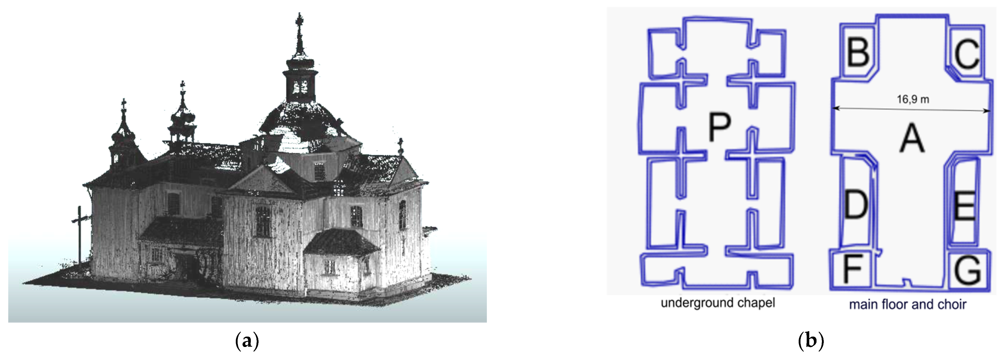





| Room | Circumference [m] | Height [m] | Area [m2] | Volume [m3] |
|---|---|---|---|---|
| P (underground) | 221.3 | 3.47 | 320.87 | 1113.42 |
| A (main nave) | 83.91 | 17.77 | 260.17 | 2556.3 |
| B | 16.66 | 4.18 | 17.5 | 73.16 |
| C | 16.1 | 3.75 | 16.34 | 61.26 |
| D | 23.17 | 3.99 | 26.7 | 106.53 |
| E | 21.65 | 3.94 | 21.64 | 85.25 |
| F | 16.13 | 4.76 | 16.19 | 77.06 |
| G | 16.04 | 4.62 | 16.01 | 73.97 |
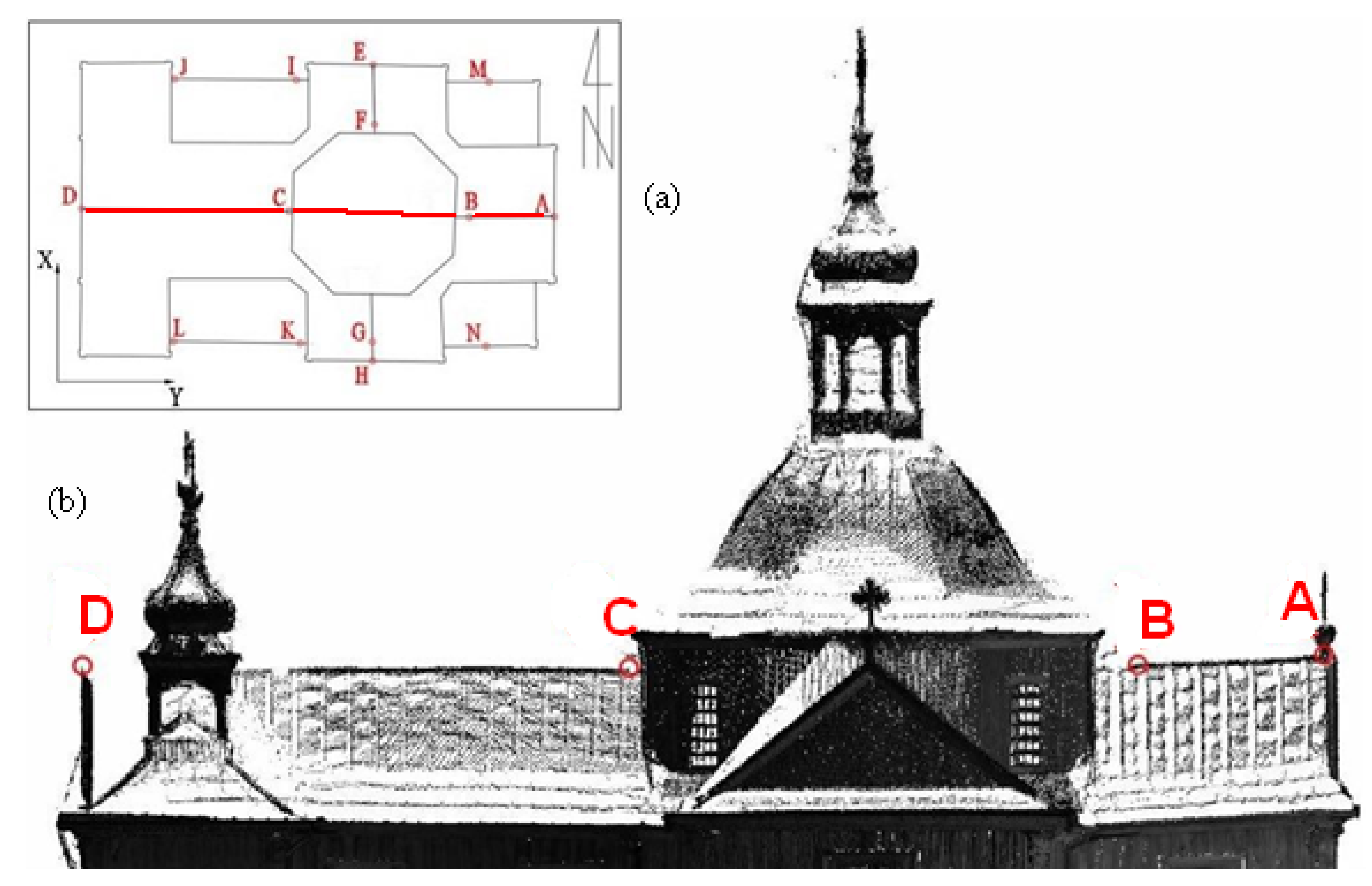
| Wall | Number of Points | Height of Walls (m) | Slope Value (mm/m) | Tilt Direction |
|---|---|---|---|---|
| A | 49 | 3.63 | 21 | South |
| B | 160 | 8.85 | 19 | South |
| C | 63 | 3.67 | 13 | South |
| D | 94 | 8.78 | 9 | South |
| E | 45 | 8.73 | 6 | West |
| F | 150 | 8.97 | 19 | West |
| G | 74 | 8.68 | 17 | West |
| H | 75 | 8.93 | 9 | South |
| I | 60 | 3.30 | 17 | South |
| J | 151 | 8.76 | 16 | South |
| K | 46 | 3.51 | 11 | South |
| L | 24 | 3.43 | 26 | West |
| M | 162 | 8.87 | 35 | West |
| N | 95 | 3.52 | 34 | West |
Publisher’s Note: MDPI stays neutral with regard to jurisdictional claims in published maps and institutional affiliations. |
© 2022 by the author. Licensee MDPI, Basel, Switzerland. This article is an open access article distributed under the terms and conditions of the Creative Commons Attribution (CC BY) license (https://creativecommons.org/licenses/by/4.0/).
Share and Cite
Lipecki, T. Non-Contact Diagnostics of the Geometry of a Historic Wooden Building as an Element of Periodic Safety Assessment. Sensors 2022, 22, 1301. https://doi.org/10.3390/s22041301
Lipecki T. Non-Contact Diagnostics of the Geometry of a Historic Wooden Building as an Element of Periodic Safety Assessment. Sensors. 2022; 22(4):1301. https://doi.org/10.3390/s22041301
Chicago/Turabian StyleLipecki, Tomasz. 2022. "Non-Contact Diagnostics of the Geometry of a Historic Wooden Building as an Element of Periodic Safety Assessment" Sensors 22, no. 4: 1301. https://doi.org/10.3390/s22041301


