
QuadNet: A Hybrid Framework for Quadrotor Dead Reckoning


Abstract
:1. Introduction
- 1.
- Provides altitude information enabling the determination of the quadrotor three-dimensional position vector;
- 2.
- The regression rate can be set at any desired time interval for the position vector estimation. For example, in [19], it was a peak-to-peak estimation occurring approximately every seven seconds, and now it was reduced to less than a second.
- 3.
- As a data-driven approach, there is no need for any calibration prior operation as required in the model-based QDR approach.
2. Problem Formulation
2.1. Inertial Navigation Systems
2.2. Quadrotor Dead Reckoning
3. Quadnet1 Framework
3.1. Proposed Approach
- 1.
- The required Weinberg gain in (9) requires precalibration and is very sensitive to the quadrotor periodic motion type.
- 2.
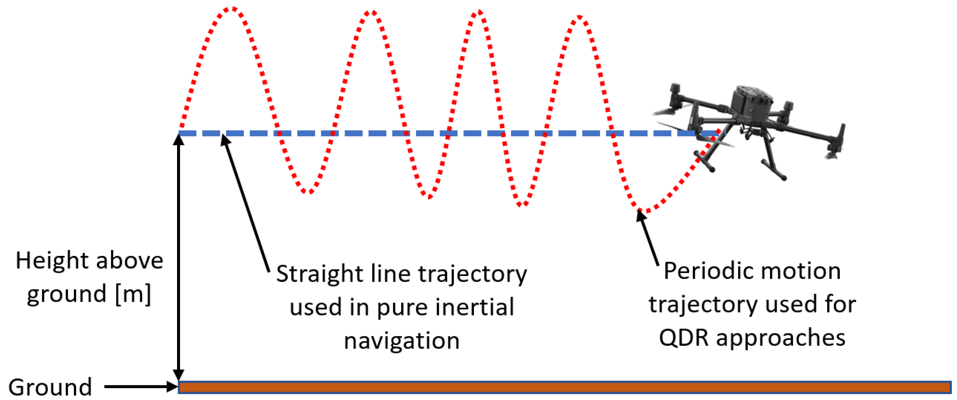
- QDR provides a position solution between two successive peaks only (p2p), where the time duration between the two peaks is several seconds.
- 3.
- The QDR approach does not provide the quadrotor altitude.
3.2. Quadnet Regression Model Architectures
- QuadNet1: consisting of one-dimensional convolution neural networks (CNN) and fully connected layers;
- QuadNet2: consisting of one-dimensional CNN, long short-term memory (LSTM) neural networks, and fully connected layers.
3.2.1. Quadnet 1
3.2.2. Quadnet 2
- 1.
- Forget Gate: Decides what information is thrown away from the cell state:where is the forget gate’s activation vector, is the sigmoid function, is the weights matrix, is the hidden state vector of the previous layer, is the input vector to the LSTM unit, and is the bias vector.
- 2.
- Input Gate: Decides which values are updated by:where is the update gate’s activation vector.
- 3.
- Cell Input State: Creates a vector of new candidate values that could be added to the state. Together with (18), it is used to create an update for the state:where is the cell input activation vector.
- 4.
- Cell State: The old state is multiplied by the forget gate’s activation function, and the input gate’s activation vector is multiplied by the cell input activation vector to obtain the updated cell state:
- 5.
- Output Gate and Hidden State: The output is based on the previous layer’s hidden state, while the hidden state is based on the cell state as described by:where is the output gate’s activation vector, and is the hidden state vector.
3.3. Loss Function
4. Data Collection and Preprocessing
4.1. Dataset
5. Analysis and Results
5.1. Performance Measure
5.2. Baseline Architecture Evaluation: Distance
5.3. Baseline Architecture Evaluation: Height
5.4. Influence of Window Size
5.5. Influence of Input Size
- 1.
- Six (baseline): Three gyroscope and three accelerometer measurements; i.e., the specific force and angular velocity vectors.
- 2.
- Three: Three accelerometer measurements; that is, only the specific force vector.
- 3.
- Two: The specific force and angular velocity magnitudes.
6. Conclusions
Author Contributions
Funding
Institutional Review Board Statement
Informed Consent Statement
Data Availability Statement
Acknowledgments
Conflicts of Interest
References
- Bouabdallah, S.; Siegwart, R. Backstepping and Sliding-mode Techniques Applied to an Indoor Micro Quadrotor. In Proceedings of the IEEE International Conference on Robotics and Automation, Barcelona, Spain, 18–22 April 2005; pp. 2247–2255. [Google Scholar]
- Wang, Y.; Wang, Y.; Dong, Y.; Ren, B. Bounded UDE-Based Control for a SLAM Equipped Quadrotor with Input Constraints. In Proceedings of the American Control Conference (ACC), Philadelphia, PA, USA, 10–12 July 2019; pp. 3117–3122. [Google Scholar]
- Goodarzi, F.A. Autonomous aerial payload delivery with quadrotor using varying length cable. In Proceedings of the International Conference on Advanced Mechatronic Systems (ICAMechS), Melbourne, VIC, Australia, 30 November–3 December 2016; pp. 394–399. [Google Scholar]
- Mathew, N.; Smith, S.L.; Waslander, S.L. Planning Paths for Package Delivery in Heterogeneous Multirobot Teams. IEEE Trans. Autom. Sci. Eng. 2015, 12, 1298–1308. [Google Scholar] [CrossRef]
- Raoult, V.; Colefax, A.P.; Allan, B.M.; Cagnazzi, D.; Castelblanco-Martínez, N.; Ierodiaconou, D.; Schofield, G. Operational protocols for the use of drones in marine animal research. Drones J. 2020, 4, 64. [Google Scholar] [CrossRef]
- Gray, P.C.; Bierlich, K.C.; Mantell, S.A.; Friedlaender, A.S.; Goldbogen, J.A.; Johnston, D.W. Drones and convolutional neural networks facilitate automated and accurate cetacean species identification and photogrammetry. Methods Ecol. Evol. J. 2019, 10, 1490–1500. [Google Scholar] [CrossRef]
- Faessler, M.; Fontana, F.; Forster, C.; Mueggler, E.; Pizzoli, M.; Scaramuzza, D. Autonomous, vision-based flight and live dense 3D mapping with a quadrotor micro aerial vehicle. J. Field Robot. 2016, 33, 431–450. [Google Scholar] [CrossRef]
- Pounds, P.E.I.; Bersak, D.R.; Dollar, A.M. Grasping from the air: Hovering capture and load stability. In Proceedings of the 2011 IEEE International Conference on Robotics and Automation, Shanghai, China, 9–13 May 2011; pp. 2491–2498. [Google Scholar]
- Popek, K.M.; Johannes, M.S.; Wolfe, K.C.; Hegeman, R.A.; Hatch, J.M.; Moore, J.L.; Yeh, B.Y.; Katyal, K.D.; Bamberger, R.J. Autonomous grasping robotic aerial system for perching (agrasp). In Proceedings of the 2018 IEEE/RSJ International Conference on Intelligent Robots and Systems, Madrid, Spain, 1–5 October 2018; pp. 1–9. [Google Scholar]
- Luo, C.; Espinosa, A.P.; Pranantha, D.; Gloria, A.D. Multi-robot search and rescue team. In Proceedings of the 2011 IEEE International Symposium on Safety, Security, and Rescue Robotics, Kyoto, Japan, 1–5 November 2011; pp. 296–301. [Google Scholar]
- Arreola, L.; de Oca, A.M.; Flores, A.; Sanchez, J.; Flores, G. Improvement in the UAV position estimation with low-cost GPS, INS and vision-based system: Application to a quadrotor UAV. In Proceedings of the International Conference on Unmanned Aircraft Systems (ICUAS), Dallas, TX, USA, 12–15 June 2018; pp. 1248–1254. [Google Scholar]
- Chiella, A.C.; Machado, H.N.; Teixeira, B.O.; Pereira, G.A. GNSS/LiDAR-based navigation of an aerial robot in sparse forests. Sensors 2019, 19, 4061. [Google Scholar] [CrossRef] [Green Version]
- Mur-Artal, R.; Montiel, J.M.M.; Tardós, J.D. ORB-SLAM: A Versatile and Accurate Monocular SLAM System. IEEE Trans. Robot. 2015, 31, 1147–1163. [Google Scholar] [CrossRef] [Green Version]
- Mur-Artal, R.; Tardós, J.D. ORB-SLAM2: An Open-Source SLAM System for Monocular, Stereo, and RGB-D Cameras. IEEE Trans. Robot. 2017, 33, 1255–1262. [Google Scholar] [CrossRef] [Green Version]
- Campos, C.; Elvira, R.; Rodríguez, J.J.G.; Montiel, J.M.M.; Tardós, J.D. ORB-SLAM3: An Accurate Open-Source Library for Visual, Visual–Inertial, and Multimap SLAM. IEEE Trans. Robot. 2021, 37, 1874–1890. [Google Scholar] [CrossRef]
- Do, T.; Carrillo-Arce, L.C.; Roumeliotis, S.I. High-speed autonomous quadrotor navigation through visual and inertial paths. Int. J. Robot. Res. 2019, 38, 486–504. [Google Scholar] [CrossRef]
- Martinez-Martin, E.; Ferrer, E.; Vasilev, I.; Pobil, A.P.D. The UJI Aerial Librarian Robot: A Quadcopter for Visual Library Inventory and Book Localisation. Sensors 2021, 21, 1079. [Google Scholar] [CrossRef]
- Titterton, D.; Weston, J.L. Strapdown Inertial Navigation Technology; American Institute of Aeronautics and Astronautics and the Institution of Electrical Engineers: New York, NY, USA, 2004. [Google Scholar]
- Shurin, A.; Klein, I. QDR: A Quadrotor Dead Reckoning Framework. IEEE Access 2020, 8, 204433–204440. [Google Scholar] [CrossRef]
- Hou, X.; Bergmann, J. Pedestrian Dead Reckoning With Wearable Sensors: A Systematic Review. IEEE Sens. J. 2021, 21, 143–152. [Google Scholar] [CrossRef]
- Manos, A.; Klein, I.; Hazan, T. Gravity-based methods for heading computation in pedestrian dead reckoning. Sensors 2019, 19, 1170. [Google Scholar] [CrossRef] [Green Version]
- Klein, I.; Solaz, Y.; Ohayon, G. Pedestrian dead reckoning with smartphone mode recognition. IEEE Sens. J. 2018, 18, 7577–7584. [Google Scholar] [CrossRef]
- Gao, W.; Hsu, D.; Lee, W.S.; Shen, S.; Subramanian, K. Intention-Net: Integrating Planning and Deep Learning for Goal-Directed Autonomous Navigation. In Proceedings of the 1st Annual Conference on Robot Learning, Proceedings of Machine Learning Research, Mountain View, CA, USA,, 13–15 November 2017; Volume 78, pp. 185–194. [Google Scholar]
- Zhu, Y.; Mottaghi, R.; Kolve, E.; Lim, J.J.; Gupta, A.; Fei-Fei, L.; Farhadi, A. Target-driven visual navigation in indoor scenes using deep reinforcement learning. In Proceedings of the IEEE International Conference on Robotics and Automation (ICRA), Singapore, 29 May–3 June 2017; pp. 3357–3364. [Google Scholar]
- Hu, H.; Zhang, K.; Tan, A.H.; Ruan, M.; Agia, C.; Nejat, G. A Sim-to-Real Pipeline for Deep Reinforcement Learning for Autonomous Robot Navigation in Cluttered Rough Terrain. IEEE Robot. Autom. Lett. 2021, 6, 6569–6576. [Google Scholar] [CrossRef]
- Elhoushi, M.; Georgy, J.; Noureldin, A.; Korenberg, M. Online motion mode recognition for portable navigation using low-cost sensors. Navigation 2015, 62, 273–290. [Google Scholar] [CrossRef]
- Shavit, Y.; Klein, I. Boosting Inertial-Based Human Activity Recognition with Transformers. IEEE Access 2021, 9, 53540–53547. [Google Scholar] [CrossRef]
- Ramanujam, E.; Perumal, T.; Padmavathi, S. Human Activity Recognition with Smartphone and Wearable Sensors Using Deep Learning Techniques: A Review. IEEE Sens. J. 2021, 21, 13029–13040. [Google Scholar] [CrossRef]
- Klein, I. Smartphone mode recognition Smartphone Location Recognition: A Deep Learning-Based Approach. Sensors 2020, 20, 214. [Google Scholar] [CrossRef] [Green Version]
- Yang, R.; Wang, B. PACP: A position-independent activity recognition method using smartphone sensors. Information 2016, 7, 72. [Google Scholar] [CrossRef] [Green Version]
- Zhou, X.; Liang, W.; Wang, K.I.K.; Wang, H.; Yang, L.T.; Jin, Q. Deep learning- enhanced human activity recognition for Internet of healthcare things. IEEE Internet Things J. 2020, 7, 6429–6438. [Google Scholar] [CrossRef]
- Vertzberger, E.; Klein, I. Attitude adaptive estimation with smartphone classification for pedestrian navigation. IEEE Sens. J. 2021, 21, 9341–9348. [Google Scholar] [CrossRef]
- Zak, I.; Katz, R.; Klein, I. MLCA – A Machine Learning Framework for INS coarse Alignment. Sensors 2020, 20, 6959. [Google Scholar] [CrossRef]
- Yona, M.; Klein, I. Compensating for Partial Doppler Velocity Log Outages by using Deep-Learning Approaches. In Proceedings of the IEEE International Symposium on Robotic and Sensors Environments (ROSE 2021), Virtual, 28–29 October 2021. [Google Scholar]
- Yan, H.; Herath, S.; Furukawa, Y. RoNIN: Robust neural inertial navigation in the wild: Benchmark, evaluations, and new methods. arXiv 2019, arXiv:1905.12853. [Google Scholar]
- Yan, H.; Shan, Q.; Furukawa, Y. RIDI: Robust IMU double integration. In Proceedings of the European Conference on Computer Vision (ECCV), Munich, Germany, 8–14 September 2018; pp. 621–636. [Google Scholar]
- Gu, F.; Khoshelham, K.; Yu, C.; Shang, J. Accurate step length estimation for pedestrian dead reckoning localization using stacked autoencoders. IEEE Trans. Instrum. Meas. 2019, 68, 2705–2713. [Google Scholar] [CrossRef]
- Chen, C.; Zhao, P.; Lu, C.X.; Wang, W.; Markham, A.; Trigoni, N. Deep-learning-based pedestrian inertial navigation: Methods, data set, and on-device inference. IEEE Internet Things J. 2020, 7, 4431–4441. [Google Scholar] [CrossRef] [Green Version]
- Asraf, O.; Shama, F.; Klein, I. PDRNet: A deep-learning pedestrian dead reckoning framework. IEEE Sens. J. 2021. [Google Scholar] [CrossRef]
- Weinberg, H. Using the ADXL202 in Pedometer and Personal Navigation Applications. Analog. Devices AN-602 Appl. Note 2002, 2, 1–6. [Google Scholar]
- Hara, K.; Saito, D.; Shouno, H. Analysis of function of rectified linear unit used in deep learning. In Proceedings of the International Joint Conference on Neural Networks (IJCNN), Killarney, Ireland, 12–17 July 2015; pp. 1–8. [Google Scholar]
- Kalchbrenner, N.; Danihelka, I.; Graves, A. Grid long short-term memory. arXiv 2015, arXiv:1507.01526. [Google Scholar]
- Shurin, A.; Saraev, A.; Yona, M.; Gutnik, Y.; Farber, S.; Etzion, A.; Klein, I. The Autonomous Platforms Inertial Dataset. IEEE Access 2022, 10, 10191–10201. [Google Scholar] [CrossRef]


| Trajectory | Actual Distance [m] | Approach | Dist. Error [m] | RMSE [m] |
|---|---|---|---|---|
| Straight line | 101.1 | INS | 143 | 41.8 |
| QDR | 1.7 | 1.6 | ||
| Periodic Motion | 80.2 | QuadNet1 | 0.08 | 0.45 |
| QuadNet2 | 1.15 | 0.85 | ||
| QDR | 1.8 | 4.95 | ||
| Periodic Motion | 95.9 | QuadNet1 | 0.02 | 1.8 |
| QuadNet2 | 1.1 | 2.1 |
| Trajectory | Actual Distance [m] | Approach | Dist. Error [m] | RMSE [m] |
|---|---|---|---|---|
| Straight line | 101.1 | INS | 459.7 | 128.2 |
| QDR | 6.9 | 6.6 | ||
| Periodic Motion | 80.2 | QuadNet1 | 2.1 | 1 |
| QuadNet2 | 3.0 | 2.3 | ||
| QDR | 6.9 | 9.2 | ||
| Periodic Motion | 95.9 | QuadNet1 | 4.3 | 2.8 |
| QuadNet2 | 6.8 | 3.9 |
| Trajectory | Approach | RMSE [m] |
|---|---|---|
| INS | 20.7 | |
| Periodic Motion | QuadNet1 | 0.5 |
| QuadNet2 | 1.3 | |
| INS | 14.7 | |
| Periodic Motion | QuadNet1 | 0.7 |
| QuadNet2 | 1.8 |
| Trajectory | Approach | RMSE [m] |
|---|---|---|
| INS | 78.7 | |
| Periodic Motion | QuadNet1 | 1.3 |
| QuadNet2 | 1.45 | |
| INS | 96.1 | |
| Periodic Motion | QuadNet1 | 1.25 |
| QuadNet2 | 1.9 |
| Trajectory | Window Size | Distance RMSE | Height RMSE |
|---|---|---|---|
| [Samples] | [m] | [m] | |
| 15 | 1.4 | 1.5 | |
| Periodic Motion | 25 | 0.5 | 0.5 |
| 50 | 0.6 | 0.6 | |
| 15 | 2.6 | 1.7 | |
| Periodic Motion | 25 | 1.8 | 0.7 |
| 50 | 1.9 | 1.1 |
| Trajectory | Input Size | Distance RMSE | Height RMSE |
|---|---|---|---|
| [Samples] | [m] | [m] | |
| 2 | 13.8 | 2.5 | |
| Periodic Motion | 3 | 3.35 | 0.7 |
| 6 | 0.45 | 0.5 | |
| 2 | 16.75 | 1.6 | |
| Periodic Motion | 3 | 4.15 | 1.05 |
| 6 | 1.8 | 0.7 |
Publisher’s Note: MDPI stays neutral with regard to jurisdictional claims in published maps and institutional affiliations. |
© 2022 by the authors. Licensee MDPI, Basel, Switzerland. This article is an open access article distributed under the terms and conditions of the Creative Commons Attribution (CC BY) license (https://creativecommons.org/licenses/by/4.0/).
Share and Cite
Shurin, A.; Klein, I. QuadNet: A Hybrid Framework for Quadrotor Dead Reckoning. Sensors 2022, 22, 1426. https://doi.org/10.3390/s22041426
Shurin A, Klein I. QuadNet: A Hybrid Framework for Quadrotor Dead Reckoning. Sensors. 2022; 22(4):1426. https://doi.org/10.3390/s22041426
Chicago/Turabian StyleShurin, Artur, and Itzik Klein. 2022. "QuadNet: A Hybrid Framework for Quadrotor Dead Reckoning" Sensors 22, no. 4: 1426. https://doi.org/10.3390/s22041426
APA StyleShurin, A., & Klein, I. (2022). QuadNet: A Hybrid Framework for Quadrotor Dead Reckoning. Sensors, 22(4), 1426. https://doi.org/10.3390/s22041426