

Application of the Concept of Land Degradation Neutrality for Remote Monitoring of Agricultural Sustainability of Irrigated Areas in Uzbekistan

Abstract
:1. Introduction
- avoiding new degradation of land by maintaining existing healthy land;
- reducing existing degradation by adopting sustainable land management practices;
- accelerating efforts to restore degraded lands to a natural or more productive state [3].
2. Materials and Methods
2.1. Researching Area
2.2. Methods
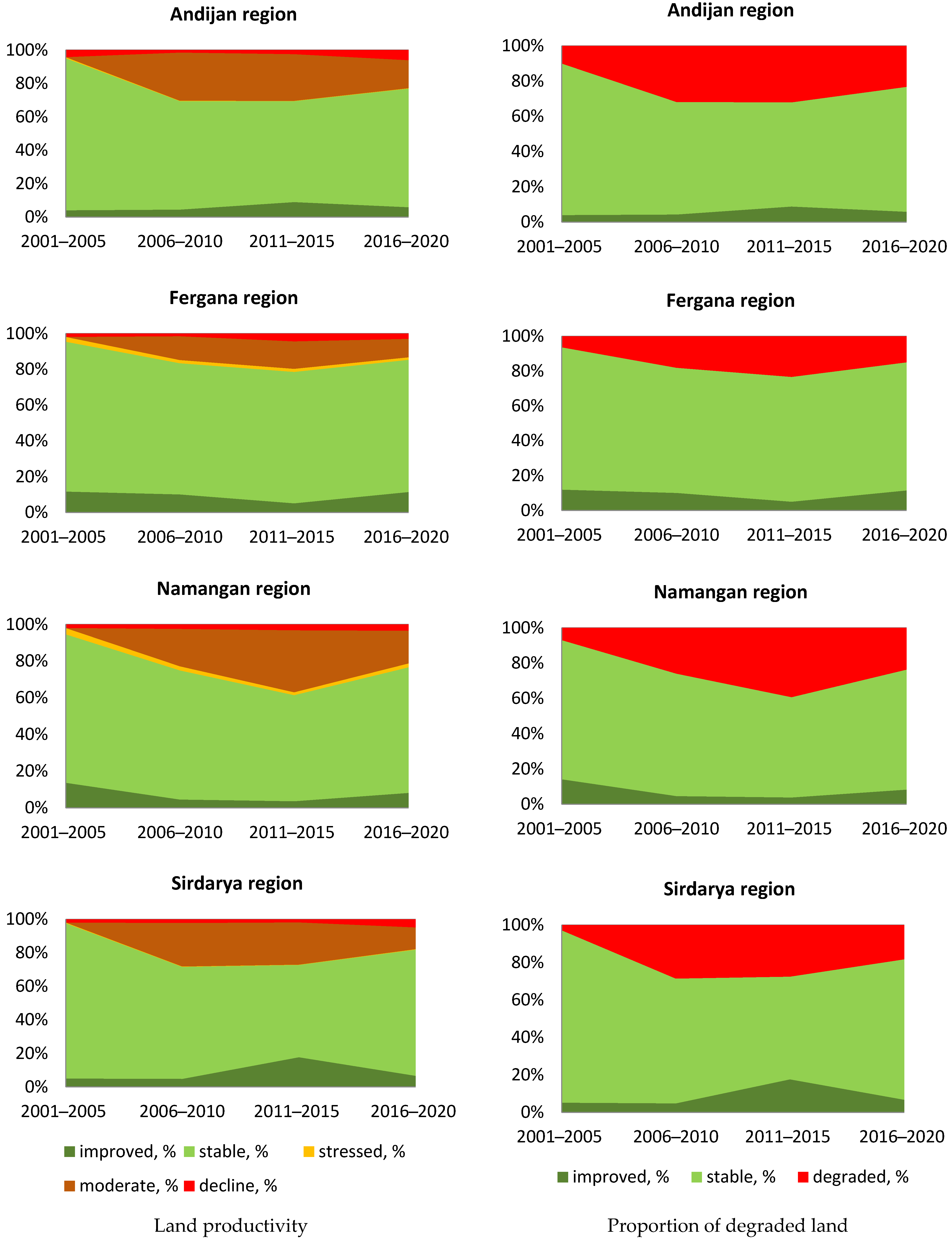
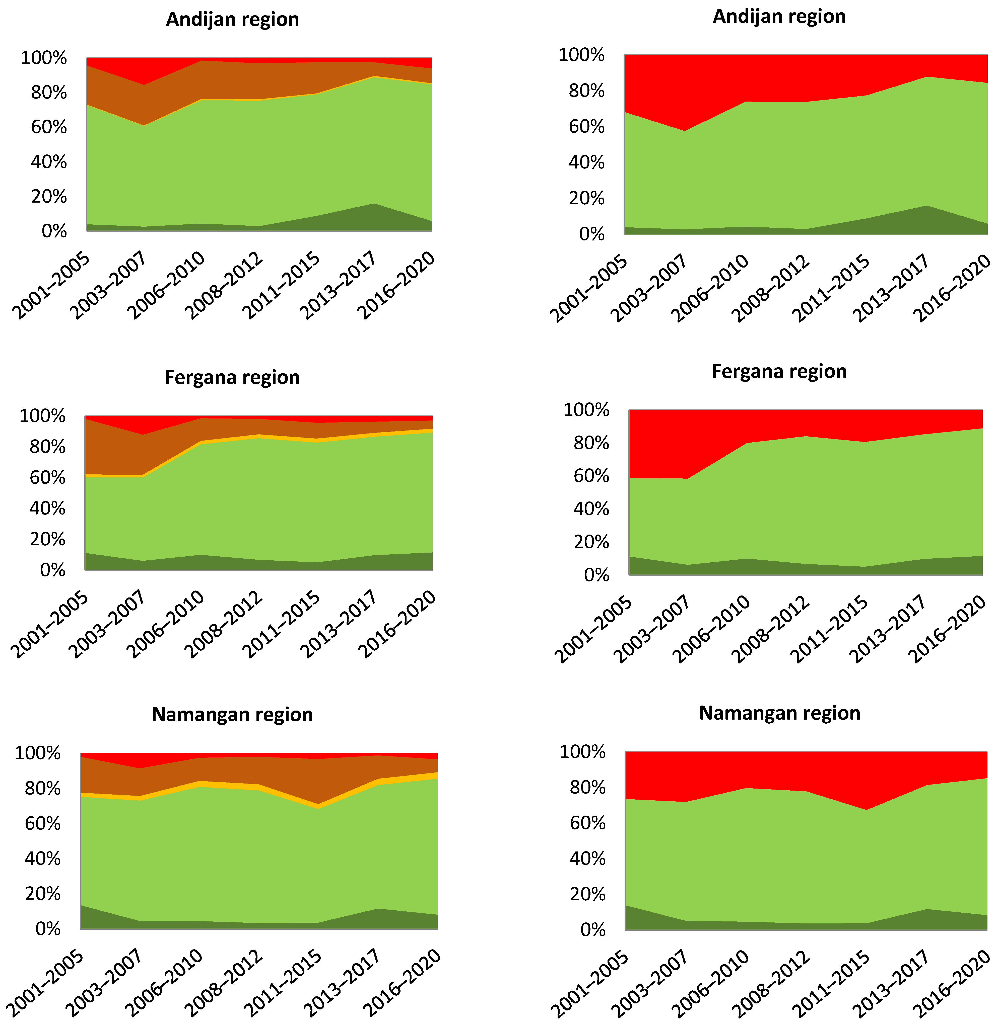
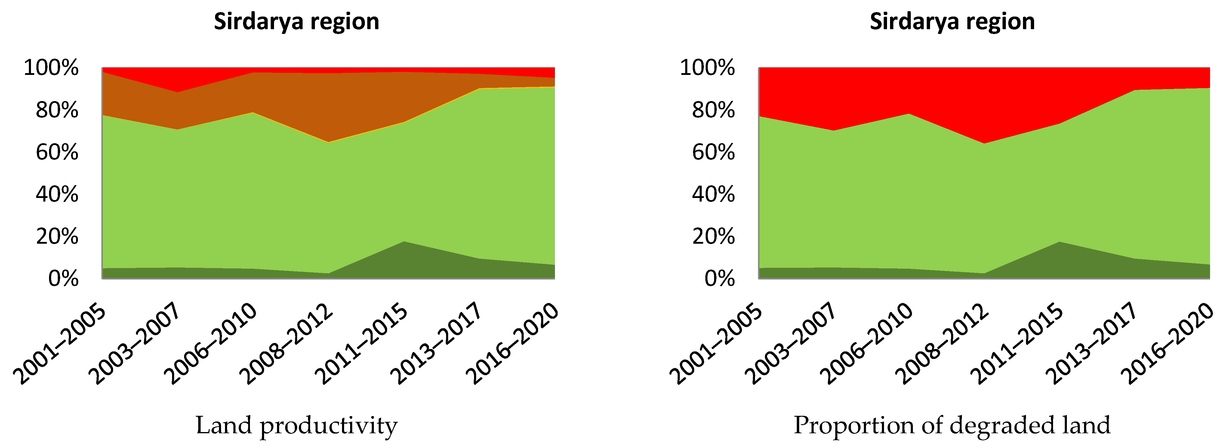
3. Results
4. Conclusions
Author Contributions
Funding
Institutional Review Board Statement
Informed Consent Statement
Data Availability Statement
Conflicts of Interest
References
- UNCCD. 3/COP.12 Integration of the Sustainable Development Goals and Targets into the Implementation of the United Nations Convention to Combat Desertification and the Intergovernmental Working Group Report on Land Degradation Neutrality. ICCD/COP(12)/20/Add.1. 2015. Available online: https://www.unccd.int/sites/default/files/sessions/documents/ICCD_COP12_20_Add.1/20add1eng.pdf (accessed on 14 June 2023).
- United Nations Department of Economic and Social Affairs. Available online: https://unstats.un.org/sdgs/metadata/files/Metadata-15-03-01.pdf (accessed on 14 June 2023).
- UNCCD. Land Degradation Neutrality. Available online: https://www.unccd.int/land-and-life/land-degradation-neutrality/overview (accessed on 14 June 2023).
- Orr, B.J.; Cowie, A.L.; Castillo, V.M.S.; Chasek, P.; Crossman, N.D.; Erlewein, A.; Welton, S. Scientific Conceptual Framework for Land Degradation Neutrality. A Report of the Science-Policy Interface; United Nations Convention to Combat Desertification (UNCCD): Bonn, Germany, 2017; Available online: https://www.unccd.int/resources/publications/scientific-conceptual-framework-land-degradation-neutrality-report-science (accessed on 14 June 2023).
- Cowie, A.L.; Orr, B.J.; Castillo Sanchez, V.M.; Chasek, P.; Crossman, N.D.; Erlewein, A.; Louwagie, G.; Maron, M.; Metternicht, G.I.; Minelli, S.; et al. Land in balance: The scientific conceptual framework for Land Degradation Neutrality. Environ. Sci. Policy 2018, 79, 25–35. [Google Scholar] [CrossRef]
- Trends.Earth. User Guide. Available online: http://docs.trends.earth/en/latest/for_users/index.html (accessed on 14 June 2023).
- Sims, N.C.; Newnham, G.J.; England, J.R.; Guerschman, J.; Cox, S.J.D.; Roxburgh, S.H.; Viscarra Rossel, R.A.; Fritz, S.; Wheeler, I. Good Practice Guidance. SDG Indicator 15.3.1, Proportion of Land That Is Degraded Over Total Land Area; Version 2.0; United Nations Convention to Combat Desertification: Bonn, Germany, 2021; Available online: https://www.unccd.int/sites/default/files/documents/2021-09/UNCCD_GPG_SDG-Indicator-15.3.1_version2_2021.pdf (accessed on 14 June 2023).
- Gonzalez-Roglich, M.; Zvoleff, A.; Noon, M.; Liniger, H.; Fleiner, R.; Harari, N.; Garcia, C. Synergizing global tools to monitor progress towards land degradation neutrality: Trends.Earth and the World Overview of Conservation Approaches and Technologies sustainable land management database. Environ. Sci. Policy 2019, 93, 34–42. [Google Scholar] [CrossRef]
- Aynekulu, E.; Lohbeck, M.; Nijbroek, R.; Ordoñez, J.C.; Turner, K.G.; Vågen, T.; Winowiecki, L. Review of Methodologies for Land Degradation Neutrality Baselines: Sub-National Case Studies from Costa Rica and Namibia; CIAT Publication No. 441; International Center for Tropical Agriculture (CIAT) and World Agroforestry Center (ICRAF): Nairobi, Kenya, 2017; 58p, Available online: http://hdl.handle.net/10568/80563 (accessed on 14 June 2023).
- Gichenje, H.; Godinho, S. Establishing a land degradation neutrality national baseline through trend analysis of GIMMS NDVI Time-series. Land Degrad. Dev. 2018, 29, 2985–2997. [Google Scholar] [CrossRef]
- Metin, A.E.; Caglak, S. Assessment of the effect of land use change on bioclimatic comfort conditions in Usak province. Turk. J. Agric. For. 2022, 46, 632–641. [Google Scholar] [CrossRef]
- Kust, G.; Andreeva, O.; Cowie, A. Land Degradation Neutrality: Concept development, practical applications and assessment. J. Environ. Manag. 2017, 195, 16–24. [Google Scholar] [CrossRef] [PubMed]
- Andreeva, O.V.; Kust, G.S.; Lobkovsky, V.A. Sustainable Land Management and Land Degradation Neutrality. Her. Russ. Acad. Sci. 2022, 92, 285–296. [Google Scholar] [CrossRef]
- Kust, G. Desertification: Principles of Ecological and Genetic Assessment and Mapping; Moscow State University named after M.V. Lomonosov” Publishing House (Printing House): Moscow, Russia, 1999; 362p, Available online: https://elibrary.ru/item.asp?id=30793814 (accessed on 14 June 2023). (In Russian)
- Nkonya, E.; Gerber, N.; Baumgartner, P.; von Braun, J.; De Pinto, A.; Graw, V.; Kato, E.; Kloos, J.; Walter, T. The Economics of Desertification, Land Degradation, and Drought toward an Integrated Global Assessment. ZEF-Discussion Papers on Development Policy No. 150. 2011. Available online: https://papers.ssrn.com/sol3/papers.cfm?abstract_id=1890668 (accessed on 14 June 2023).
- Mirzabaev, A.; Ahmed, M.; Werner, J.; Pender, J.; Louhaichi, M. Rangelands of Central Asia: Challenges and opportunities. J. Arid Land 2016, 8, 93–108. [Google Scholar] [CrossRef] [Green Version]
- Chen, T.; Tang, G.; Yuan, Y.; Guo, H.; Xu, Z.; Jiang, G.; Chen, X. Unraveling the relative impacts of climate change and human activities on grassland productivity in Central Asia over last three decades resource. Sci. Total Environ. 2020, 743, 140649. [Google Scholar] [CrossRef] [PubMed]
- Avetisyan, S. Land Resources and Food Security of Central Asia and the Caucasus; Some Features of the Use of Land Resources in Agriculture in the Post-Soviet Space; Food and Agriculture Organization of the United Nations: Rome, Italy, 2016; pp. 24–49. Available online: https://www.fao.org/3/I5914B/i5914b.pdf (accessed on 14 June 2023). (In Russian)
- Li, Z.; Chen, Y.; Fang, G.; Li, Y. Multivariate assessment and attribution of droughts in Central Asia. Sci. Rep. 2017, 7, 1316. [Google Scholar] [CrossRef] [PubMed] [Green Version]
- Deng, H.; Yin, Y.; Han, X. Vulnerability of vegetation activities to drought in Central Asia. Environ. Res. Lett. 2020, 15, 084005. [Google Scholar] [CrossRef]
- Yakubov, M.A.; Yakubov, H.E.; Yakubov, S.H. Central Asia Reservoir and Drainage Flow Assessment and Irrigation Use. Tashkent. 2011. Available online: http://cawater-info.net/library/rus/cdf_ru.pdf (accessed on 14 June 2023). (In Russian).
- Suleimenov, M.K. Where is Central Asian Agriculture Headed? 2012. Available online: https://kazakh-zerno.net/72549-kuda-idet-selskoe-khozyajstvo-tsentralnoj-azii/ (accessed on 14 June 2023). (In Russian).
- Presidential Decree on Measures for the Effective Use of Land and Water Resources in Agriculture. 2019. Available online: https://lex.uz/ru/docs/4378524#4380363 (accessed on 14 June 2023). (In Russian).
- Nigmajanov, U.H. Country’s Land Holdings and Categories; Tashkent Institute of Irrigation Engineers and Agricultural Mechanization. Available online: https://staff.tiiame.uz/storage/users/443/presentations/lE3stmlaq2bAkJFFotdfspJVc07b6H8tySUdmCr9.pdf (accessed on 14 June 2023). (In Russian).
- Cracknell, A.P. The Advanced Very High Resolution Radiometer (AVHRR); Taylor and Francis: Abingdon, UK, 1997; 534p. [Google Scholar]
- ESA. Land Cover CCI Product User Guide. Version 2. Tech. Rep.. 2017. Available online: http://maps.elie.ucl.ac.be/CCI/viewer/download/ESACCI-LC-Ph2-PUGv2_2.0.pdf (accessed on 14 June 2023).
- New Release of the C3S Global Land Cover Products for 2016, 2017 and 2018 Consistent with the CCI 1992—2015 Map Series. The European Space Agency, 2019. Available online: http://www.esa-landcover-cci.org/?q=node/197 (accessed on 14 June 2023).
- Bryzzhev, A.V.; Rukhovich, D.I.; Koroleva, P.V. Organization of retrospective monitoring of the soil cover in Azov district of Rostov oblast. Eurasian Soil Sci. 2015, 48, 1029–1049. [Google Scholar] [CrossRef]
- Ismonov, A.J.; Abdurakhmanov, N.Y.; Karimov, H.N.; Kalandarov, N.N.; Tursunov, S.T. Soils of the Central Fergana region and their changes under irrigation. Sci. Rev. Biol. Sci. 2018, 3, 12–17. Available online: https://science-biology.ru/ru/article/view?id=1102#:~:text=%D0%A1%D0%BE%D0%B4%D0%B5%D1%80%D0%B6%D0%B0%D0%BD%D0%B8%D0%B5%20%D0%B3%D1%83%D0%BC%D1%83%D1%81%D0%B0%20%D0%B2%20%D0%BF%D0%B0%D1%85%D0%BE%D1%82%D0%BD%D0%BE%D0%BC%20%D0%B3%D0%BE%D1%80%D0%B8%D0%B7%D0 (accessed on 14 June 2023). (In Russian).
- Ruziyeva, I.Z. Soil conditions of irrigated central Fergana lands. Sci. Rev. Biol. Sci. 2019, 2, 69–73. Available online: https://science-biology.ru/ru/article/view?id=1150 (accessed on 14 June 2023). (In Russian).
- Jiang, L.; Bao, A.; Jiapaer, G.; Liu, R.; Yuan, Y.; Yu, T. Monitoring land degradation and assessing its drivers to support sustainable development goal 15.3 in Central Asia. Sci. Total Environ. 2022, 807, 150868. [Google Scholar] [CrossRef] [PubMed]
- Aw-Hassan, A.; Korol, V.; Nishanov, N.; Djanibekov, U.; Dubovyk, O.; Mirzabaev, A. Economics of land degradation and improvement in Uzbekistan. In Economics of land Degradation and Improvement—A Global Assessment for Sustainable Development; Springer: Cham, Switzerland, 2016; pp. 651–682. [Google Scholar] [CrossRef] [Green Version]
- Gafurova, L.; Juliev, M. Soil Degradation Problems and Foreseen Solutions in Uzbekistan. In Regenerative Agriculture: What’s Missing? What Do We Still Need to Know? Springer International Publishing: Cham, Switzerland, 2021; pp. 59–67. [Google Scholar] [CrossRef]
- NIST/SEMATECH e-Handbook of Statistical Methods. 2012. Available online: http://www.itl.nist.gov/div898/handbook/ (accessed on 14 June 2023).
- Statistics Agency under the President of the Republic of Uzbekistan. Agriculture. Available online: https://stat.uz/en/official-statistics/agriculture (accessed on 14 June 2023).
- Andreeva, O.; Sebentsov, A.; Kust, G.; Kolosov, V. Study on Land Degradation, Climate Change and Migration Nexus in Central Asia. UNCCD. 2022. Available online: https://www.unccd.int/resources/case-studies/study-land-degradation-climate-change-and-migration-nexus-central-asia (accessed on 14 June 2023).
- Kuvaiskova, Y.; Klyachkin, V. Statistical Forecasting Methods: A Training Manual; Ulyanovsk State Technical University: Ulyanovsk, Russia, 2019; 197p. (In Russian) [Google Scholar]
- Utemisova, A.; Kunakbaev, T. Analytical alignment of time series by moving mean. Math. Softw. Syst. Ind. Soc. Spheres 2018, 6, 49–52. Available online: https://ssi.magtu.ru/doc/2018-2/all.pdf#page=51 (accessed on 14 June 2023). (In Russian).


| Region | Total Area, Thousand Hectares | Agricultural Lands | Irrigated Lands in Total (Incl. Farmlands, Forests, Horticulture, etc.) | ||
|---|---|---|---|---|---|
| Thousand Hectares | % | Thousand Hectares | % | ||
| Andijan | 430.3 | 255.4 | 59.4 | 274.2 | 63.7 |
| Namangan | 718.1 | 387.9 | 54.0 | 290.0 | 40.4 |
| Fergana | 700.5 | 320.4 | 45.7 | 368.5 | 52.6 |
| Syrdarya | 427.6 | 287.4 | 67.2 | 286.3 | 67.0 |
| Uzbekistan (in total) | 44,892.4 | 25,639.0 | 57.1 | 4329.0 | 9.6 |
| LDN Indicator | Data Set | Resolution (Meters) | Time Period |
|---|---|---|---|
| Land Cover | ESA CCI LC | 300 | 1992–2020 |
| Land Productivity (NDVI) | MOD13Q1 | 250 | 18 February 2000–17 February 2023 |
| Soil Organic Carbon | Soil Grids | 250 | 2020 |
Disclaimer/Publisher’s Note: The statements, opinions and data contained in all publications are solely those of the individual author(s) and contributor(s) and not of MDPI and/or the editor(s). MDPI and/or the editor(s) disclaim responsibility for any injury to people or property resulting from any ideas, methods, instructions or products referred to in the content. |
© 2023 by the authors. Licensee MDPI, Basel, Switzerland. This article is an open access article distributed under the terms and conditions of the Creative Commons Attribution (CC BY) license (https://creativecommons.org/licenses/by/4.0/).
Share and Cite
Kust, G.; Andreeva, O.; Shklyaeva, D. Application of the Concept of Land Degradation Neutrality for Remote Monitoring of Agricultural Sustainability of Irrigated Areas in Uzbekistan. Sensors 2023, 23, 6419. https://doi.org/10.3390/s23146419
Kust G, Andreeva O, Shklyaeva D. Application of the Concept of Land Degradation Neutrality for Remote Monitoring of Agricultural Sustainability of Irrigated Areas in Uzbekistan. Sensors. 2023; 23(14):6419. https://doi.org/10.3390/s23146419
Chicago/Turabian StyleKust, German, Olga Andreeva, and Darya Shklyaeva. 2023. "Application of the Concept of Land Degradation Neutrality for Remote Monitoring of Agricultural Sustainability of Irrigated Areas in Uzbekistan" Sensors 23, no. 14: 6419. https://doi.org/10.3390/s23146419