
Correction of Thin Cirrus Absorption Effects in Landsat 8 Thermal Infrared Sensor Images Using the Operational Land Imager Cirrus Band on the Same Satellite Platform


Abstract
:1. Introduction
2. Background and Methods
2.1. Background on Cirrus Contamination Effects in Landsat 8/9 Data Products
2.2. The Landsat 8/9 OLI and TIRS Instruments
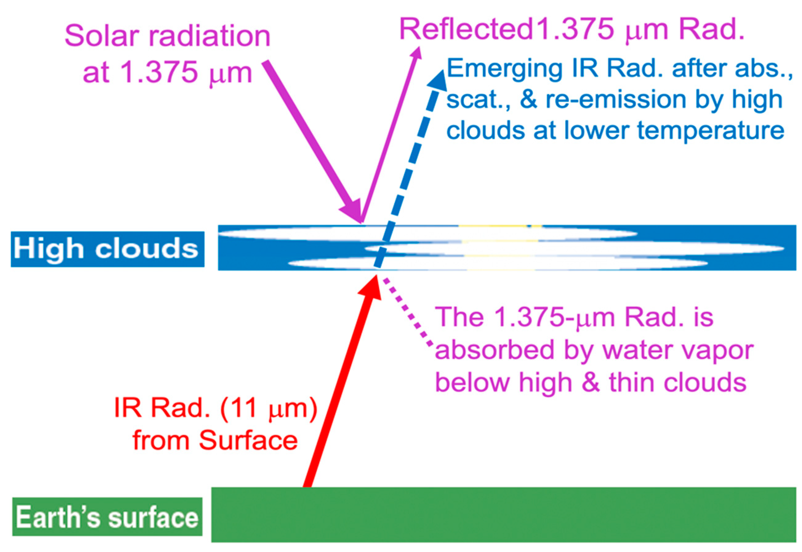
2.3. Cirrus Absorption and Scattering Properties
2.4. Removal of Cirrus Effects in Landsat 8 OLI Images for Bands in the 0.4–2.5 μm Range
2.5. The Linear Relationship between 1.375-μm Band Cirrus Scattering and 11-μm Band Ice Absorption
3. Results
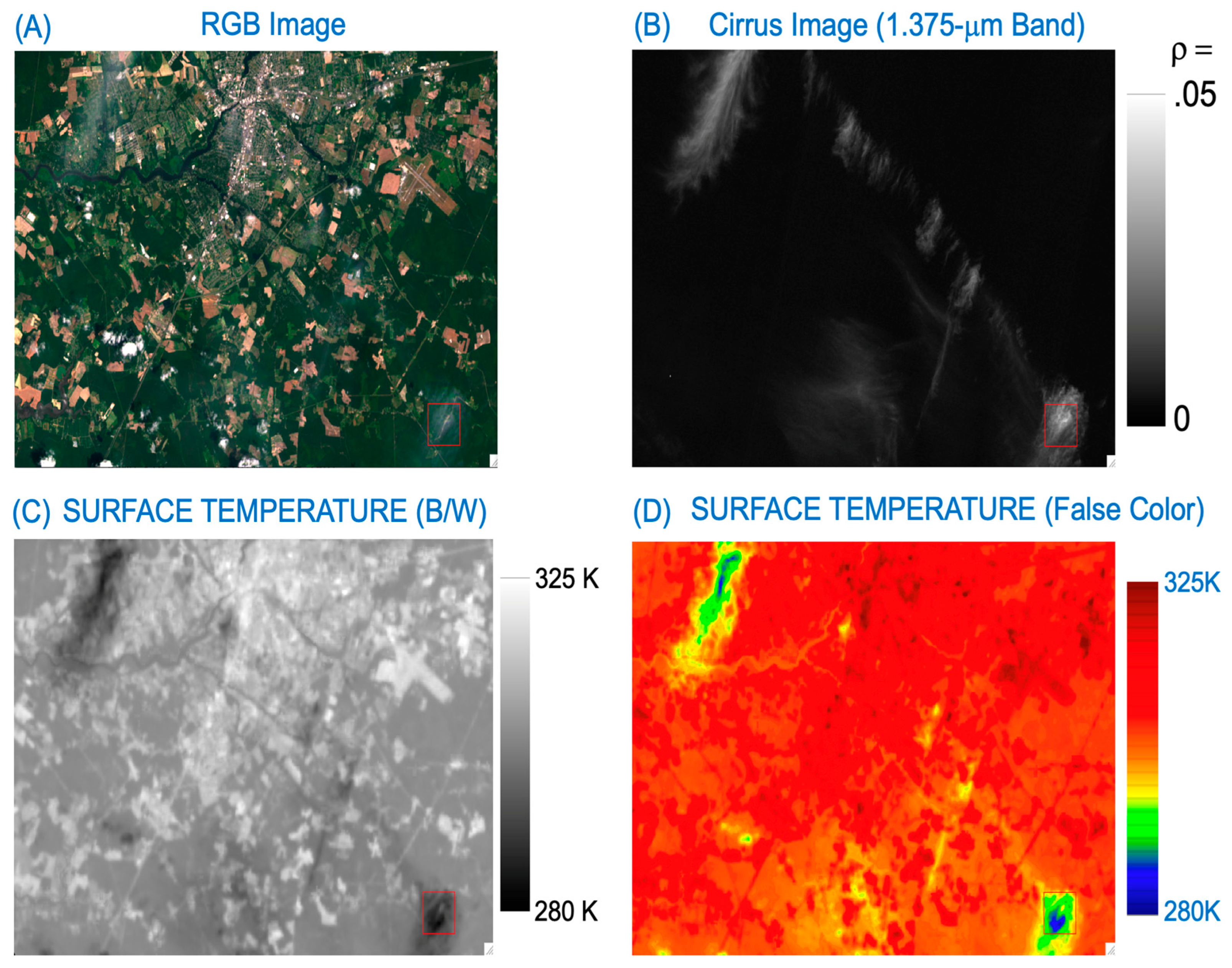
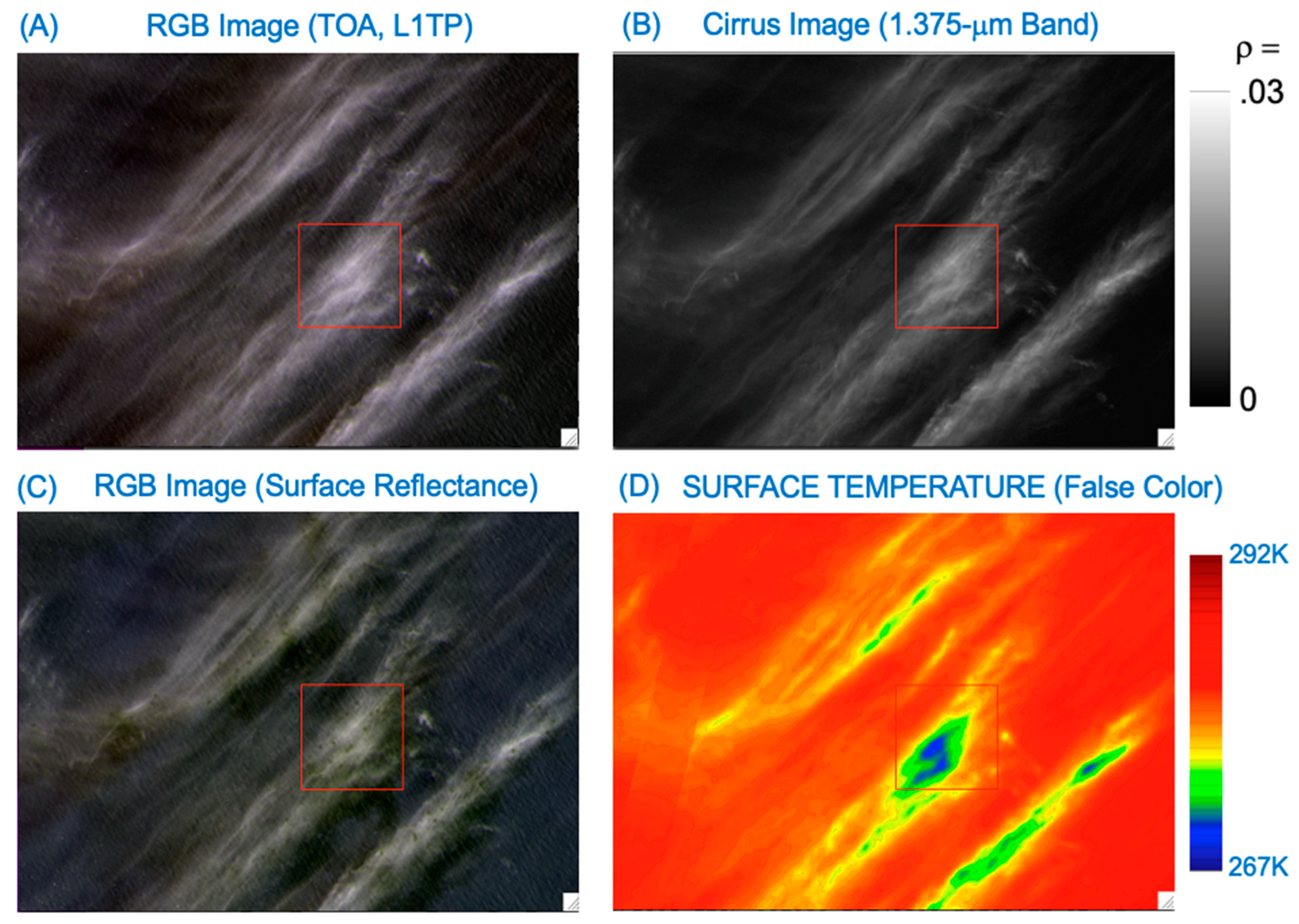
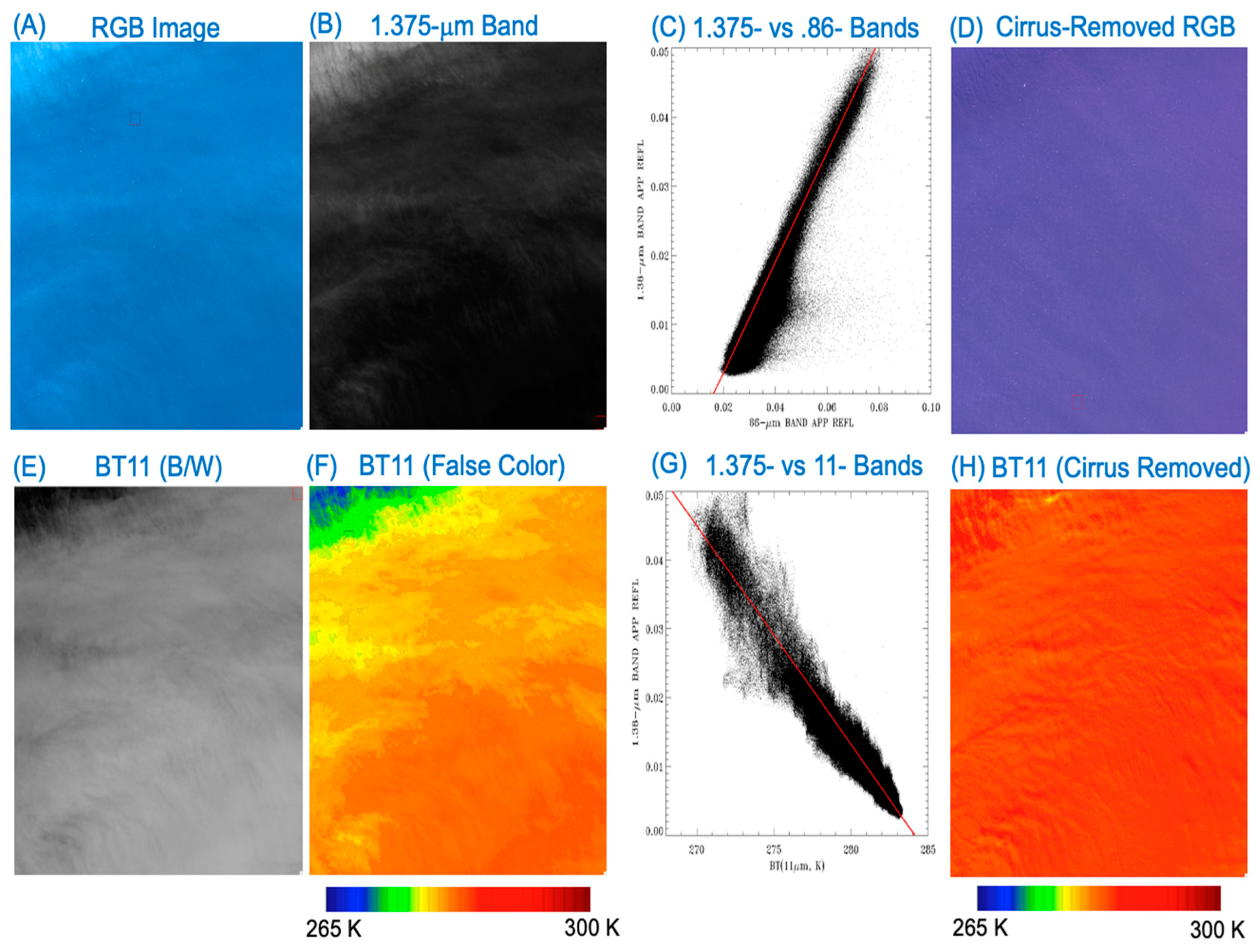
3.1. A Water Scene West of the Coastal Area of Chile, 21 March 2014
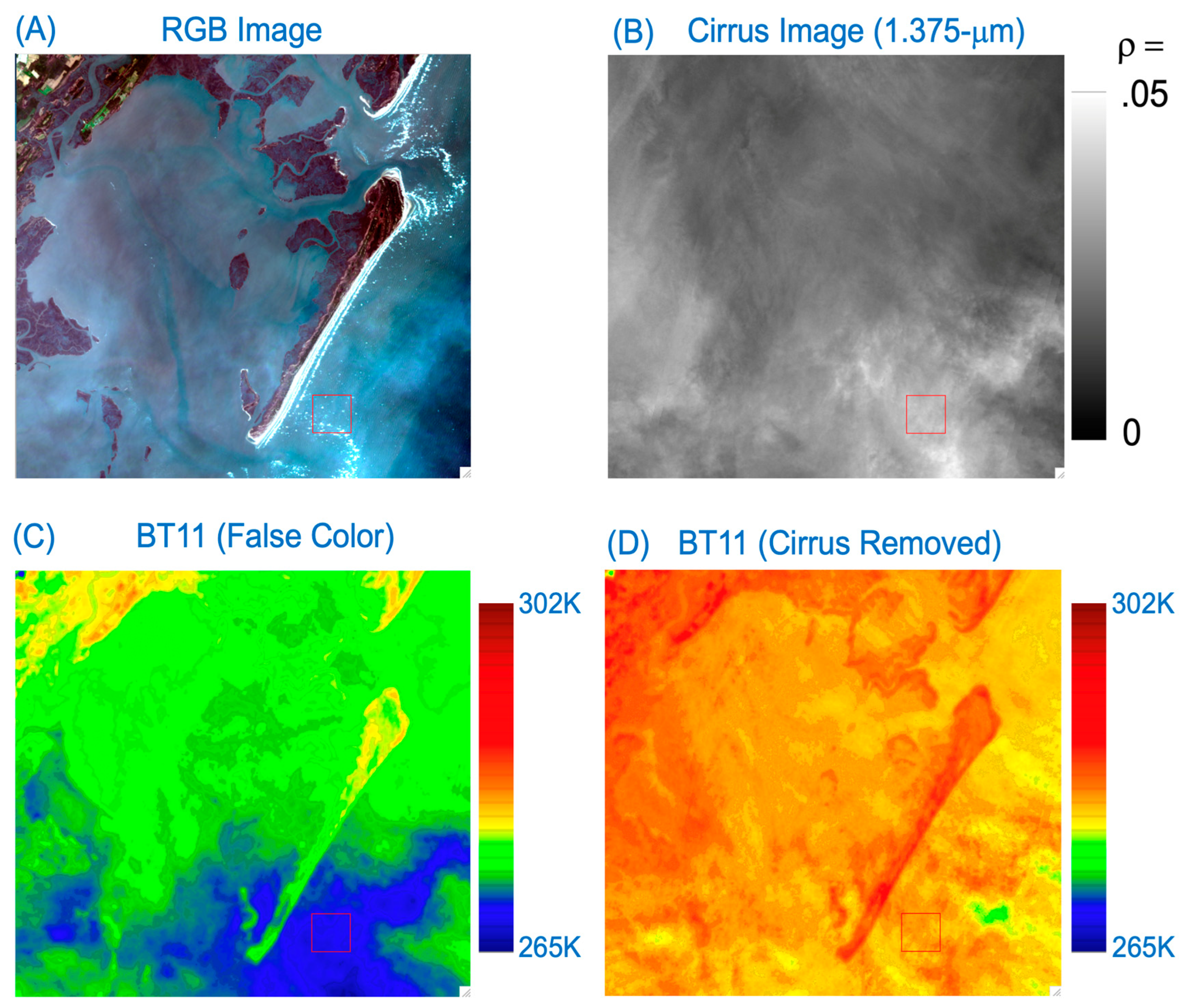
3.2. A Land/Water Boundary Scene, Maryland, USA, 17 April 2014
3.3. A Water Scene, Baltic Sea, 11 August 2015
4. Discussion
5. Summary
Author Contributions
Funding
Data Availability Statement
Conflicts of Interest
References
- Landsat 8-9 Calibration and Validation (Cal/Val) Algorithm Description Document (ADD). Available online: https://www.usgs.gov/media/files/landsat-8-9-calibration-validation-algorithm-description-document (accessed on 1 January 2020).
- Landsat 8-9 Collection 2 (C2) Level 2 Science Product (L2SP) Guide. Available online: https://www.usgs.gov/media/files/landsat-8-9-collection-2-level-2-science-product-guide (accessed on 1 January 2020).
- Gao, B.-C.; Kaufman, Y.J. Selection of the 1.375-µm MODIS channel for remote sensing of cirrus clouds and stratospheric aerosols from space. J. Atmos. Sci. 1995, 52, 4231–4237. [Google Scholar] [CrossRef]
- Anderson, M.C.; Norman, J.M.; Kustas, W.P.; Houborg, R.; Starks, P.J.; Agam, N. A thermal-based remote sensing technique for routine mapping of land-surface carbon, water and energy fluxes from field to regional scales. Remote Sens. Environ. 2008, 112, 4227–4241. [Google Scholar] [CrossRef]
- Malakar, N.K.; Hulley, G.C.; Hook, S.J.; Laraby, K.; Cook, M.; Schott, J.R. An Operational Land Surface Temperature Product for Landsat Thermal Data: Methodology and Validation. IEEE Trans. Geosci. Remote Sens. 2018, 56, 5717–5735. [Google Scholar] [CrossRef]
- Hulley, G.C.; Hook, S.J.; Abbott, E.; Malakar, N.; Islam, T.; Abrams, M. The ASTER Global Emissivity Dataset (ASTER GED): Mapping Earth’s emissivity at 100 meter spatial scale. Geophys. Res. Lett. 2015, 42, 7966–7976. [Google Scholar] [CrossRef]
- Salomonson, V.V.; Barnes, W.L.; Maymon, P.W.; Montgomery, H.E.; Ostrow, H. MODIS: Advanced facility instrument for studies of the earth as a system. IEEE Trans. Geosci. Remote Sens. 1989, 27, 145–153. [Google Scholar] [CrossRef]
- King, M.D.; Menzel, W.P.; Kaufman, Y.J.; Tanre, D.; Gao, B.-C.; Platnick, S.; Ackerman, S.A.; Remer, L.A.; Pincus, R.; Hubanks, P.A.; et al. Cloud and aerosol properties, precipitable water, and profiles of temperature and humidity from MODIS. IEEE Trans. Geosci. Remote Sens. 2003, 41, 442–458. [Google Scholar] [CrossRef]
- Laraby, K.G.; Schott, J.R. Uncertainty estimation method and Landsat 7 global validation for the Landsat surface temperature product. Remote Sens. Environ. 2018, 216, 472–481. [Google Scholar] [CrossRef]
- Schaeffer, B.A.; Iiames, J.; Dwyer, J.; Urquhart, E.; Salls, W.; Rover, J.; Seegers, B. An initial validation of Landsat 5 and 7 derived surface water temperature for U.S. lakes, reservoirs, and estuaries. Int. J. Remote Sens. 2018, 39, 7789–7805. [Google Scholar] [CrossRef]
- Shi, J.; Hu, C. Evaluation of ECOSTRESS thermal data over south Florida estuaries. Sensors 2021, 21, 4341. [Google Scholar] [CrossRef]
- Weidberg, N.; Wethey, D.S.; Woodin, S.A. Global intercomparison of hyper-resolution ECOSTRESS coastal sea surface temperature measurements from the Space Station with VIIRS-N20. Remote Sens. 2021, 13, 5021. [Google Scholar] [CrossRef]
- Melton, F.S.; Huntington, J.; Grimm, R.; Herring, J.; Hall, M.; Rollison, D.; Erickson, T.; Allen, R.; Anderson, M.; Fisher, J.B.; et al. OpenET: Filling a Critical Data Gap in Water Management for the Western United States. J. Am. Water Resour. Assoc. 2021, 58, 971–994. [Google Scholar] [CrossRef]
- Gao, B.-C.; Li, R.-R. Removal of thin cirrus scattering effects in Landsat 8 OLI images using the cirrus detecting channel. Remote Sens. 2017, 9, 834. [Google Scholar] [CrossRef]
- Kneizys, F.X.; Shettle, E.P.; Abreu, L.W.; Chetwynd, J.H.; Anderson, G.P.; Gallery, W.O.; Selby, J.E.A.; Clough, S.A. Users Guide to LOWTRAN7, AFGL-TR-88-0177; Environmental Research Papers, No. 1010; Air Force Geophysics Laboratory: Middlesex County, MA, USA, 1988. [Google Scholar]
- U.S. Standard Atmosphere. National Oceanic and Atmospheric Administration, National Aeronautics and Space Administration, United States Air Force, Washington, D.C., October 1976. 1976. Available online: https://www.ngdc.noaa.gov/stp/space-weather/online-publications/miscellaneous/us-standard-atmosphere-1976/us-standard-atmosphere_st76-1562_noaa.pdf (accessed on 1 January 2020).
- Gao, B.-C.; Li, R.-R.; Shettle, E.P. Cloud remote sensing using midwave IR CO2 and N2O slicing channels near 4.5 μm. Remote Sens. 2011, 3, 1006–1013. [Google Scholar] [CrossRef]
- Wei, H.; Yang, P.; Li, J.; Baum, B.A.; Huang, H.L.; Platnick, S.; Hu, Y.; Strow, L. Retrieval of semitransparent ice cloud optical thickness from atmospheric infrared sounder (AIRS) measurements. IEEE Trans. Geosci. Remote Sens. 2004, 47, 2254–2267. [Google Scholar]
- Yang, P.; Hioki, S.; Saito, M.; Kuo, C.-P.; Baum, B.A.; Liou, K.-N. A review of ice cloud optical property models for passive satellite remote sensing. Atmosphere 2018, 9, 499. [Google Scholar] [CrossRef]
- King, M.; Tsay, S.; Platnick, S.; Wang, M.; Liou, K.-N. Cloud Retrieval Algorithms for MODIS: Optical Thickness, Effective Particle Radius, and Thermodynamic Phase, MODIS Algorithm Theoretical Basis Document No. ATBD-MOD-05. 1997. Available online: https://modis.gsfc.nasa.gov/data/atbd/atbd_mod05.pdf (accessed on 1 January 2020).
- Platnick, S.; King, M.; Meyer, K.; Wind, G.; Amarasinghe, N.; Marchant, B.; Arnold, G.T.; Zhang, Z.; Hubanks, P.A.; Ridgway, B.; et al. MODID Cloud Optical Properties: User Guide for Collection 6 Level-2 MOD06/MYD06 Product and Associated level-3 Datasets. 2015. Available online: https://modis-images.gsfc.nasa.gov/_docs/C6MOD06OPUserGuide.pdf (accessed on 1 January 2020).
- Gao, B.-C.; Kaufman, Y.J.; Han, W.; Wiscombe, W.J. Correction of thin cirrus path radiance in the 0.4–1.0 µm spectral region using the sensitive 1.375-µm cirrus detecting channel. J. Geophys. Res. 1998, 103, 32169–32176. [Google Scholar] [CrossRef]
- Gao, B.-C.; Yang, P.; Han, W.; Li, R.-R.; Wiscombe, W.J. An algorithm using visible and 1.38-micron channels to retrieve cirrus cloud reflectances from aircraft and satellite data. IEEE Trans. Geosci. Remote Sens. 2002, 40, 1659–1668. [Google Scholar] [CrossRef]
- Gao, B.-C.; Li, R.-R. The VIIRS cirrus reflectance algorithm. Sensors 2023, 23, 2234. [Google Scholar] [CrossRef] [PubMed]
- Knight, E.J.; Kvaran, G. Landsat-8 operational land imager design, characterization and performance. Remote Sens. 2014, 6, 10286–10305. [Google Scholar] [CrossRef]
- Storey, J.; Choate, M.; Lee, K. Landsat 8 operational land imager on-orbit geometric calibration and performance. Remote Sens. 2014, 6, 11127–11152. [Google Scholar] [CrossRef]
- Nguyen, B.Q.; Tran, T.-N.; Grodzka-Łukaszewska, M.; Sinicyn, G.; Lakshmi, V. Assessment of urbanization-induced land-use change and its impact on temperature, evaporation, and humidity in central Vietnam. Water 2022, 14, 3367. [Google Scholar] [CrossRef]


| Bands | Wavelength (μm) | Resolution (m) |
|---|---|---|
| Band 1–Ultra Blue | 0.43–0.45 | 30 |
| Band 2–Blue | 0.45–0.51 | 30 |
| Band 3–Green | 0.53–0.59 | 30 |
| Band 4–Red | 0.64–0.67 | 30 |
| Band 5–Near-Infrared (NIR) | 0.85–0.88 | 30 |
| Band 6–Shortwave Infrared (SWIR) 1 | 1.57–1.65 | 30 |
| Band 7–Shortwave Infrared (SWIR) 2 | 2.11–2.29 | 30 |
| Band 8–Panchromatic | 0.50–0.68 | 15 |
| Band 9–Cirrus | 1.36–1.39 | 30 |
| Band 10–Thermal Infrared (TIRS) 1 | 10.6–11.19 | 100 |
| Band 11–Thermal Infrared (TIRS) 2 | 11.5–12.51 | 100 |
Disclaimer/Publisher’s Note: The statements, opinions and data contained in all publications are solely those of the individual author(s) and contributor(s) and not of MDPI and/or the editor(s). MDPI and/or the editor(s) disclaim responsibility for any injury to people or property resulting from any ideas, methods, instructions or products referred to in the content. |
© 2024 by the authors. Licensee MDPI, Basel, Switzerland. This article is an open access article distributed under the terms and conditions of the Creative Commons Attribution (CC BY) license (https://creativecommons.org/licenses/by/4.0/).
Share and Cite
Gao, B.-C.; Li, R.-R.; Yang, Y.; Anderson, M. Correction of Thin Cirrus Absorption Effects in Landsat 8 Thermal Infrared Sensor Images Using the Operational Land Imager Cirrus Band on the Same Satellite Platform. Sensors 2024, 24, 4697. https://doi.org/10.3390/s24144697
Gao B-C, Li R-R, Yang Y, Anderson M. Correction of Thin Cirrus Absorption Effects in Landsat 8 Thermal Infrared Sensor Images Using the Operational Land Imager Cirrus Band on the Same Satellite Platform. Sensors. 2024; 24(14):4697. https://doi.org/10.3390/s24144697
Chicago/Turabian StyleGao, Bo-Cai, Rong-Rong Li, Yun Yang, and Martha Anderson. 2024. "Correction of Thin Cirrus Absorption Effects in Landsat 8 Thermal Infrared Sensor Images Using the Operational Land Imager Cirrus Band on the Same Satellite Platform" Sensors 24, no. 14: 4697. https://doi.org/10.3390/s24144697
APA StyleGao, B.-C., Li, R.-R., Yang, Y., & Anderson, M. (2024). Correction of Thin Cirrus Absorption Effects in Landsat 8 Thermal Infrared Sensor Images Using the Operational Land Imager Cirrus Band on the Same Satellite Platform. Sensors, 24(14), 4697. https://doi.org/10.3390/s24144697