Assessing Derawan Island’s Coral Reefs over Two Decades: A Machine Learning Classification Perspective
Abstract
:1. Introduction
2. Materials and Methods
2.1. Study Area
2.2. Data
2.2.1. Landsat-7
2.2.2. Landsat 9
2.2.3. Sentinel-2
2.2.4. Multispectral Aerial Photography
2.2.5. Underwater Photo Transects (UPT)
2.3. Methodology
2.3.1. Data Processing
- 1.
- Recapitulation and Validation of UPT Data and Multispectral Aerial Photography: To calculate the coverage of the coral reef ecosystem, the UPT (Underwater Photo Transect) data was processed using the Coral Net platform [41]. This UPT data, crucial for assessing the ecosystem coverage, involved capturing images with GoPro cameras and GPS sets for precise location data. Each image underwent a detailed analysis using a 10 × 10 grid pattern, totaling 100 points (Figure 3). At this stage, every UPT point represented a 50 × 50 cm area, providing a high-resolution view of the coral reef. This meticulous examination included classifying the benthic environment at each grid point into detailed categories such as hard coral, soft coral, sand, algae, rock, rubble, and seagrass. This comprehensive classification, as depicted in Figure 1h, facilitated an in-depth understanding of the diverse benthic habitats present in each image. Furthermore, the UPT point interpretation of the 50 × 50 cm areas served as a reference to upscale the analysis to larger areas of 10 × 10 m. In this scaling-up process, the classification scheme was simplified into broader categories: coral, sand-rubble, seagrass, and mixed bottom class (Figure 1i). This modification was essential for matching the UPT data with the grid used in Sentinel-2 multispectral aerial photography. This integration of fine-scale UPT analysis and larger-scale satellite data, along with the adjusted classification scheme, allowed for a more comprehensive monitoring and understanding of the coral reef ecosystem. It ensured that the ecosystem was analyzed in a detailed and multi-scaled manner, crucial for accurate ecosystem assessments and conservation efforts.
- 2.
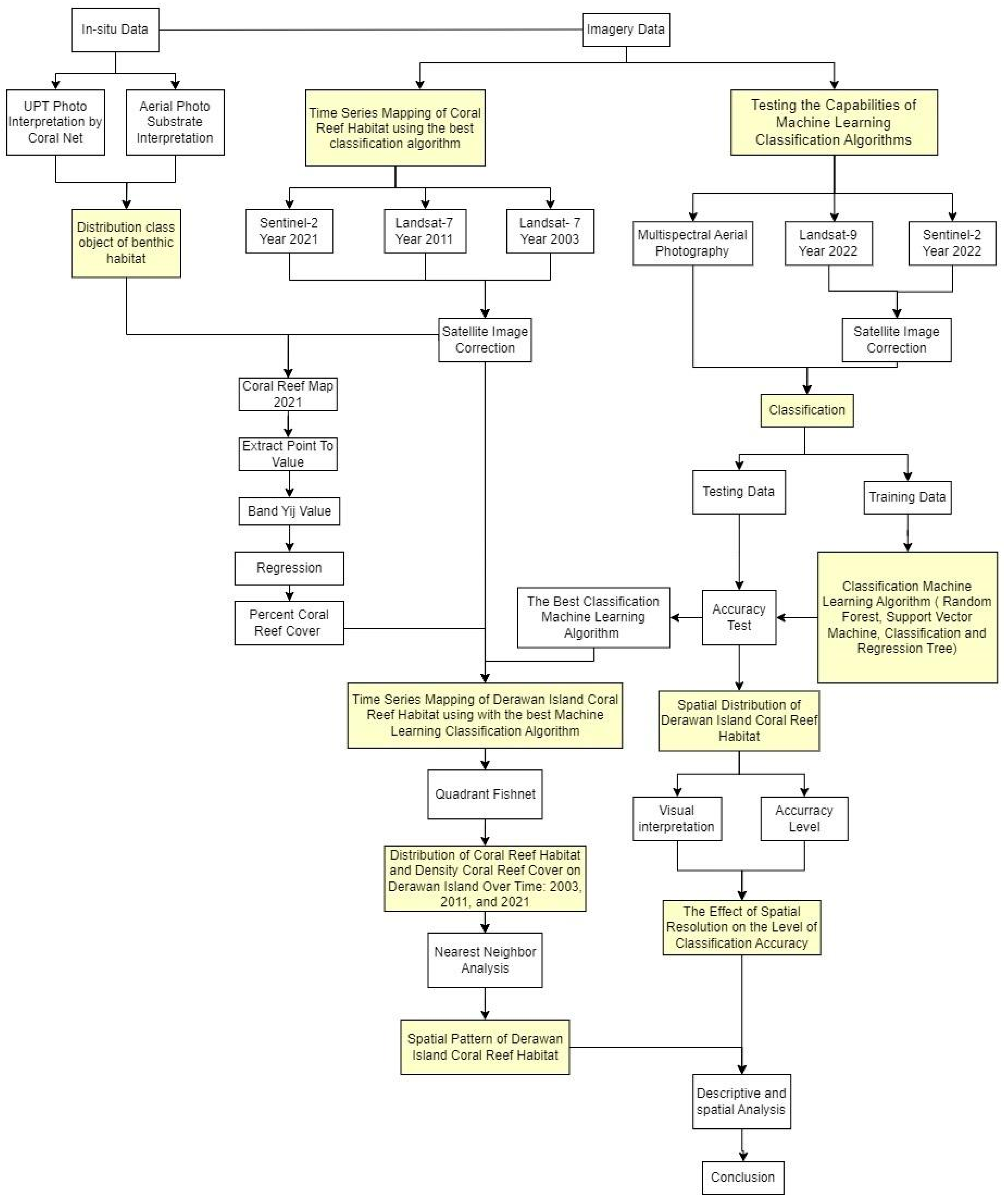
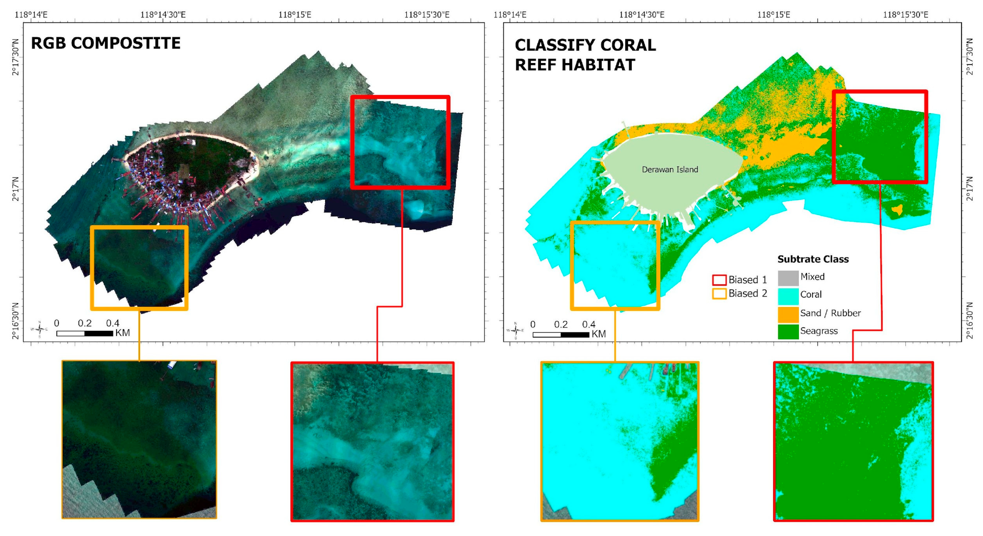
- Benthic Habitat Classification: Prior to implementing the classification algorithms, we applied necessary corrections to the satellite and UAV imagery, including adjustments for water surface and water column using the Lyzenga algorithm (Depth Invariant Index-Yij) [42]. This preparatory step was crucial to account for variations due to water depth and surface conditions, ensuring a more accurate base for habitat analysis [43,44]. In this phase of our study, we aimed to harmonize the available datasets from different remote sensing platforms. Although we did not have Landsat 9 images from 2021, we used the closest available satellite imagery from 2022, along with Sentinel-2 images from the same year. This was complemented by UAV-based multispectral aerial photos taken in December 2021, coinciding with the date of the Underwater Photo Transects (UPT). This alignment in data collection dates allowed for a coherent framework in our comprehensive benthic habitat assessment, despite the slight temporal mismatch with the Landsat 9 data. Given the spatial resolution limitations of the satellite images, we simplified the detailed UPT classification scheme into broader categories more compatible with the satellite data. These categories included ‘coral’ (encompassing both hard and soft coral), ‘sand/rubble’ (merging sand and rubble), ‘seagrass’, and ‘mixed bottom’ (incorporating algae, rock, and other mixed elements). Such simplification was vital to align with the spatial resolution capabilities of the Landsat 7, Landsat 9, and Sentinel-2 imagery, thereby ensuring a more accurate and feasible classification process. We adapted the ground truth labels for algorithm training to this revised scheme and divided the dataset into training (70%) and testing (30%) sets. The accuracy of each classification algorithm—RF, SVM, and CART—was then assessed using the confusion matrix method, ensuring a robust evaluation of our benthic habitat classification approach.
- 3.
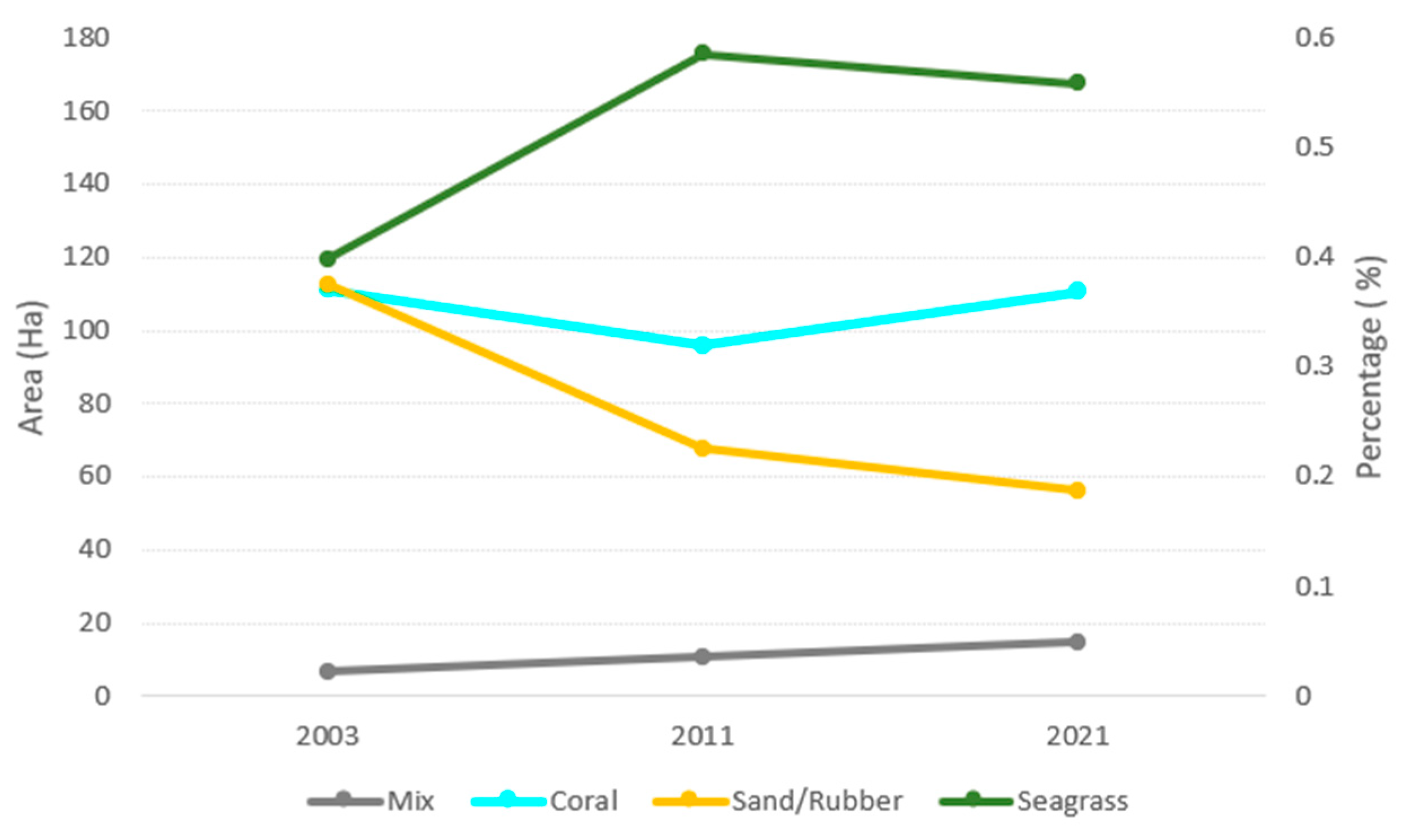
- Temporal Distribution Mapping: Following the machine learning classification tests, the best-performing algorithm was then applied to a comprehensive timeseries of satellite multispectral imagery. This timeseries spanned from 2003 to 2021 and included data from both Landsat 7 and Sentinel-2 satellites. This approach allowed us to analyze changes in the coral reef ecosystem of Derawan Island over an extended period, providing valuable insights into temporal patterns and trends. To facilitate a balanced and accurate comparison across different years and satellite sources, we resampled the Sentinel-2 satellite image classification results to a 30 m resolution. This was necessary to align with the resolution of the Landsat 7 satellite images. The combined and harmonized dataset was then visualized, where we constructed a detailed map showcasing the temporal distribution and evolution of the coral reef ecosystem from 2003 to 2021. This map not only highlighted the spatial changes but also served as a crucial tool for understanding the long-term environmental dynamics affecting the coral reefs around Derawan Island.
- 4.
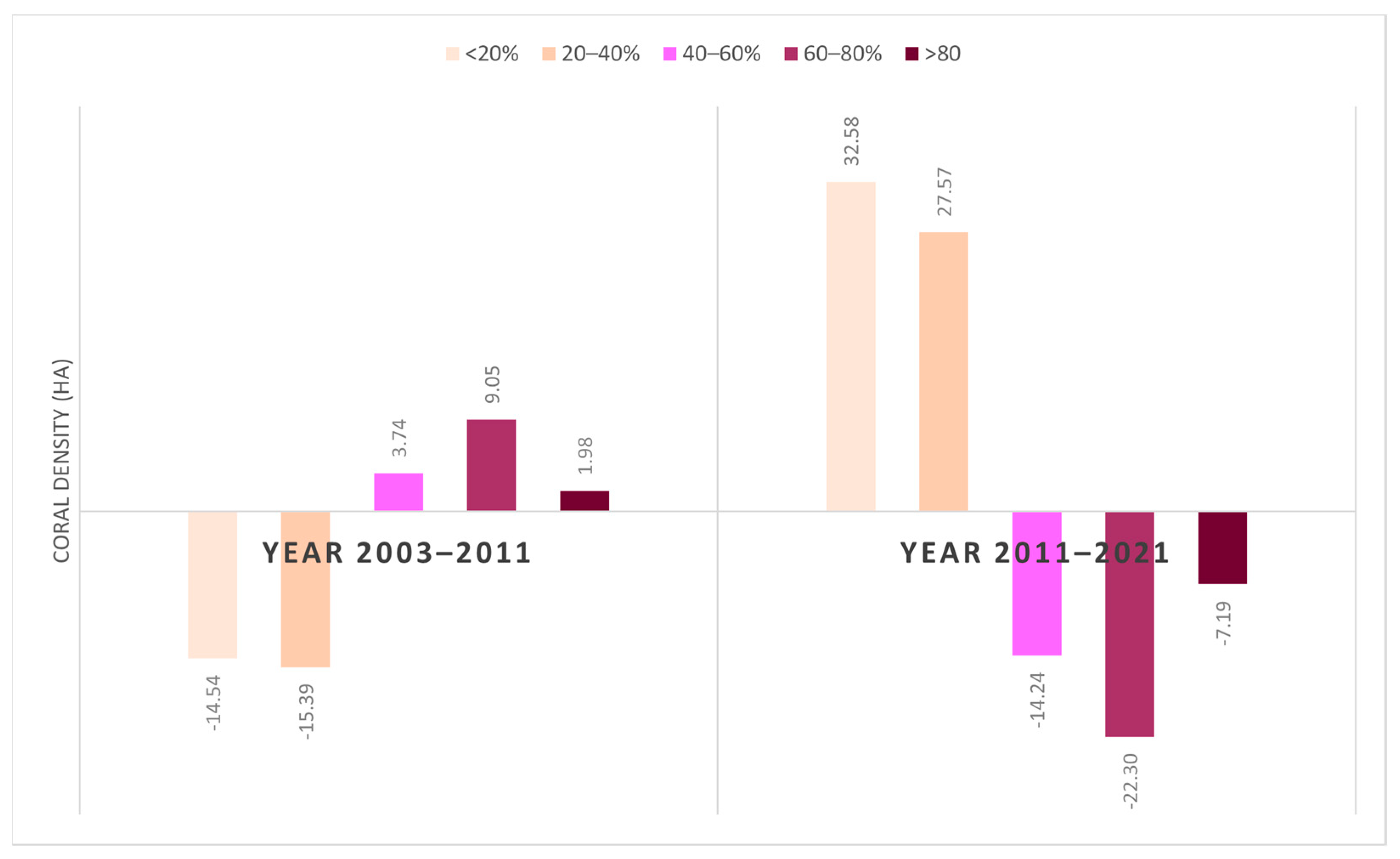
- Mapping Changes in Coral Reef Habitat Density: After the temporal mapping of the coral reef ecosystem around Derawan Island from 2003, 2011, and 2021, we further refined our analysis by focusing exclusively on the coral reef class. We masked out all other classes from our classification results to isolate the coral reef areas. The next critical step involved calculating the density of the selected coral reef class areas, which was derived from our previous classification process. This calculation was achieved through RF regression analysis, correlating the observed coral reef density from the UPT dataset with the Yi band values. These computations utilized image reflectance data from the timeseries and Yij band values from the Depth Invariant Index algorithm. The indicator of coral reef density was an essential component in our study, offering insights into the spatial distribution and density changes of coral reefs over the studied period, thus providing a more nuanced understanding of the ecosystem’s dynamics and health.
- 5.
- Analysis of Spatial Distribution Patterns: To analyze the spatial distribution and temporal change patterns in the coral reef ecosystem around Derawan Island, we utilized the fishnet tool in GIS. This tool facilitated the creation of a grid-like quadrant area over the entire study region, effectively segmenting the area into smaller, manageable units. This segmentation was crucial for a detailed and systematic analysis of spatial patterns, as it allowed us to examine the distribution of coral reefs within each quadrant and observe variations across different sections of the study area.
2.3.2. Machine Learning Classification
- 1.
- Random Forest
- 2.
- Support Vector Machine
- 3.
- Classification and Regression Tree
3. Result
3.1. The Effect of Spatial Resolution on the Level of Classification Accuracy of the Machine Learning Algorithm
3.2. Temporal Pattern of Changes in Derawan Island Coral Reef Habitats in 2003, 2011, and 2021
3.3. Coral Reef Density over a Decade on Derawan Island
4. Discussion
5. Conclusions
Supplementary Materials
Author Contributions
Funding
Institutional Review Board Statement
Informed Consent Statement
Data Availability Statement
Conflicts of Interest
References
- Thornton, S.; Richardson, L.J. Learn the Risks Our World’s Coral Reefs Are Facing and What They Mean for Our Future and the Future of the Ocean. National Geographic. Available online: https://education.nationalgeographic.org/resource/coral-reefs/ (accessed on 20 December 2023).
- Hoegh-Guldberg, O.; Poloczanska, E.S.; Skirving, W.; Dove, S. Coral Reef Ecosystems under Climate Change and Ocean Acidification. Front. Mar. Sci. 2017, 4, 158. [Google Scholar] [CrossRef]
- D’Angelo, C.; Wiedenmann, J. Impacts of Nutrient Enrichment on Coral Reefs: New Perspectives and Implications for Coastal Management and Reef Survival. Curr. Opin. Environ. Sustain. 2014, 7, 82–93. [Google Scholar] [CrossRef]
- Houk, P.; Castro, F.; McInnis, A.; Rucinski, M.; Starsinic, C.; Concepcion, T.; Manglona, S.; Salas, E. Nutrient Thresholds to Protect Water Quality, Coral Reefs, and Nearshore Fisheries. Mar. Pollut. Bull. 2022, 184, 114144. [Google Scholar] [CrossRef] [PubMed]
- Baird, M.E.; Mongin, M.; Rizwi, F.; Bay, L.K.; Cantin, N.E.; Morris, L.A.; Skerratt, J. The Effect of Natural and Anthropogenic Nutrient and Sediment Loads on Coral Oxidative Stress on Runoff-Exposed Reefs. Mar. Pollut. Bull. 2021, 168, 112409. [Google Scholar] [CrossRef]
- NOAA. How Do Coral Reefs Benefit the Economy? NOAA. Available online: https://oceanservice.noaa.gov/facts/coral_economy.html (accessed on 10 November 2023).
- Burke, L.; Spalding, M. Shoreline Protection by the World’s Coral Reefs: Mapping the Benefits to People, Assets, and Infrastructure. Mar. Policy 2022, 146, 105311. [Google Scholar] [CrossRef]
- Chafid, F. Basics of Natural Tourism Management; Liberty Offset: Yogyakarta, Indonesia, 1995. [Google Scholar]
- House of Representative of Indonesia Republic. Academic Manuscript of the Bill Concerning Conservation of Biological Resources and Their Ecosystems; House of Representative of Indonesia Republic: Jakarta, Indonesia, 2017; 173p.
- Lillesand, T.; Kiefer, R.W.; Chipman, J. Remote Sensing and Image Interpretation, 7th ed.; Wiley: Hoboken, NJ, USA, 2015. [Google Scholar]
- Prawoto, C.D.; Hartono, H. Benthic Habitat Mapping with Sentinel-2A Multispectral Imagery in the Waters of Menjangan Kecil and Menjangan Besar Islands, Karimunjawa Islands. J. Bumi Indones. 2018, 7, 260747. [Google Scholar]
- Hedley, J.D.; Roelfsema, C.; Brando, V.; Giardino, C.; Kutser, T.; Phinn, S.; Mumby, P.J.; Barrilero, O.; Laporte, J.; Koetz, B. Coral Reef Applications of Sentinel-2: Coverage, Characteristics, Bathymetry and Benthic Mapping with Comparison to Landsat 8. Remote Sens. Environ. 2018, 216, 598–614. [Google Scholar] [CrossRef]
- Brodie, J.; Ash, L.V.; Tittley, I.; Yesson, C. A Comparison of Multispectral Aerial and Satellite Imagery for Mapping Intertidal Seaweed Communities. Aquat. Conserv. Mar. Freshw. Ecosyst. 2018, 28, 872–881. [Google Scholar] [CrossRef]
- Zhang, C. Applying Data Fusion Techniques for Benthic Habitat Mapping and Monitoring in a Coral Reef Ecosystem. ISPRS J. Photogramm. Remote Sens. 2015, 104, 213–223. [Google Scholar] [CrossRef]
- Wicaksono, P.; Aryaguna, P.A.; Lazuardi, W. Benthic Habitat Mapping Model and Cross Validation Using Machine-Learning Classification Algorithms. Remote Sens. 2019, 11, 1279. [Google Scholar] [CrossRef]
- Li, A.S.; Chirayath, V.; Segal-Rozenhaimer, M.; Torres-Perez, J.L.; van den Bergh, J. NASA NeMO-Net’s Convolutional Neural Network: Mapping Marine Habitats with Spectrally Heterogeneous Remote Sensing Imagery. IEEE J. Sel. Top. Appl. Earth Obs. Remote Sens. 2020, 13, 5115–5133. [Google Scholar] [CrossRef]
- Li, X.-M.; Ma, Y.; Leng, Z.-H.; Zhang, J.; Lu, X.-X. High-Accuracy Remote Sensing Water Depth Retrieval for Coral Islands and Reefs Based on LSTM Neural Network. J. Coast. Res. 2020, 102, 21–32. [Google Scholar] [CrossRef]
- Li, J.; Knapp, D.E.; Fabina, N.S.; Kennedy, E.V.; Larsen, K.; Lyons, M.B.; Murray, N.J.; Phinn, S.R.; Roelfsema, C.M.; Asner, G.P. A Global Coral Reef Probability Map Generated Using Convolutional Neural Networks. Coral Reefs 2020, 39, 1805–1815. [Google Scholar] [CrossRef]
- Wan, J.; Ma, Y. Multi-Scale Spectral-Spatial Remote Sensing Classification of Coral Reef Habitats Using CNN-SVM. J. Coast. Res. 2020, 102, 11–20. [Google Scholar] [CrossRef]
- Burns, C.; Bollard, B.; Narayanan, A. Machine-Learning for Mapping and Monitoring Shallow Coral Reef Habitats. Remote Sens. 2022, 14, 2666. [Google Scholar] [CrossRef]
- Dang, K.B.; Nguyen, T.H.T.; Nguyen, H.D.; Truong, Q.H.; Vu, T.P.; Pham, H.N.; Duong, T.T.; Giang, V.T.; Nguyen, D.M.; Bui, T.H.; et al. U-Shaped Deep-Learning Models for Island Ecosystem Type Classification, a Case Study in Con Dao Island of Vietnam. One Ecosyst. 2022, 7, e79160. [Google Scholar] [CrossRef]
- Franceschini, S.; Meier, A.C.; Suan, A.; Stokes, K.; Roy, S.; Madin, E.M.P. A Deep Learning Model for Measuring Coral Reef Halos Globally from Multispectral Satellite Imagery. Remote Sens. Environ. 2023, 292, 113584. [Google Scholar] [CrossRef]
- Chen, C.; Liang, J.; Yang, G.; Sun, W. Spatio-Temporal Distribution of Harmful Algal Blooms and Their Correlations with Marine Hydrological Elements in Offshore Areas, China. Ocean Coast. Manag. 2023, 238, 106554. [Google Scholar] [CrossRef]
- Pratama, M.R.A.; Manessa, M.D.M.; Supriatna, S.; Ayu, F.; Haidar, M. Spatial Distribution of Coral Reef Degradation with Human Activities in the Coastal Waters of Samatellu Lompo Island, South Sulawesi. Geoplanning 2022, 9, 121–132. [Google Scholar] [CrossRef]
- Marine and Fisheries Ministry. Number of Indonesian Islands. Available online: https://kkp.go.id/djprl/p4k/page/4270-jumlah-pulau (accessed on 3 November 2023).
- Ramdhan, M.; Arifin, T. Application of Geographic Information System for Assessment of Indonesia Marine Proportion. J. Ilm. Geomatika 2013, 19, 141–146. [Google Scholar]
- UNESCO. World Heritage. Conv. Concering Protrction World Curtural Nat. Herit. 2005, 41, 41-5055. [Google Scholar] [CrossRef]
- Indonesian Ministry of Tourism and Creative Economy. The Exoticism of the Derawan Islands, a Charming Hidden Paradise. Available online: https://www.indonesia.travel/id/id/destinasi/kalimantan/derawan-archipelago/eksotisme-kepulauan-derawan-surga-tersembunyi-yang-menawan (accessed on 12 November 2023).
- Brandl, S.J.; Rasher, D.B.; Côté, I.M.; Casey, J.M.; Darling, E.S.; Lefcheck, J.S.; Duffy, J.E. Coral Reef Ecosystem Functioning: Eight Core Processes and the Role of Biodiversity. Front. Ecol. Environ. 2019, 17, 445–454. [Google Scholar] [CrossRef]
- Bara’langi’, L.N.T.; Yusuf, S.; Rani, C.; Husain, A.A.A.; Tresnati, J.; Tuwo1, A. Zooxanthellae Density in Different Zone and Life Form in Inner and Outer Zone of Spermonde Islands. J. Ilmu Kelaut. Spermonde 2021, 7, 27–35. [Google Scholar]
- Guan, Y.; Hohn, S.; Merico, A. Suitable Environmental Ranges for Potential Coral Reef Habitats in the Tropical Ocean. PLoS ONE 2015, 10, e0128831. [Google Scholar] [CrossRef] [PubMed]
- Russell, B.J.; Dierssen, H.M.; Hochberg, E.J. Water Column Optical Properties of Pacific Coral Reefs Across Geomorphic Zones and in Comparison to Offshore Waters. Remote Sens. 2019, 11, 1757. [Google Scholar] [CrossRef]
- Saputra, S.A.; Yuda, I.P.; Zahida, F. Keanekaragaman Dan Penutupan Terumbu Karang di Pantai Pasir Putih, Jawa Timur. Ph.D. Thesis, Universitas Atma Jaya Yogyakarta, Yogyakarta, Indonesia, 2016. [Google Scholar]
- Elisha, O.D.; Felix, M.J. Destruction of Coastal Ecosystems and the Vicious Cycle of Poverty in Niger Delta Region. J. Glob. Agric. Ecol. 2021, 11, 7–24. [Google Scholar]
- East Kalimatan Province MMarine and Fisheries Office. Identification and Mapping of Zoning of Marine Conservation Areas and Small Islands (KKP3K) of Kutai Kartanegara District. 2022. Available online: http://repository.unmul.ac.id/handle/123456789/47337 (accessed on 4 November 2023).
- NOAA. Pacific Climate Update Coral Bleaching Heat Stress Analysis and Seasonal Guidance through September 2022. Available online: https://coralreefwatch.noaa.gov/satellite/analyses_guidance/pacific_cbts_ag_20220531.php (accessed on 31 October 2023).
- King, M.D.; Platnick, S. The Earth Observing System (EOS). In Comprehensive Remote Sensing; Elsevier: Amsterdam, The Netherlands, 2018; pp. 7–26. [Google Scholar] [CrossRef]
- Markham, B.L.; Jenstrom, D.; Masek, J.G.; Dabney, P.; Pedelty, J.A.; Barsi, J.A.; Montanaro, M. Landsat 9: Status and Plans; Butler, J.J., Xiong, X., Gu, X., Eds.; NASA: Washington, DC, USA, 2016; p. 99720G. [CrossRef]
- Park, H.; Choi, J.; Park, N.; Choi, S. Sharpening the VNIR and SWIR Bands of Sentinel-2A Imagery through Modified Selected and Synthesized Band Schemes. Remote Sens. 2017, 9, 1080. [Google Scholar] [CrossRef]
- Wu, Z.; Snyder, G.; Vadnais, C.; Arora, R.; Babcock, M.; Stensaas, G.; Doucette, P.; Newman, T. User Needs for Future Landsat Missions. Remote Sens. Environ. 2019, 231, 111214. [Google Scholar] [CrossRef]
- Chen, Q.; Beijbom, O.; Chan, S.; Bouwmeester, J.; Kriegman, D. A New Deep Learning Engine for CoralNet. In Proceedings of the IEEE/CVF International Conference on Computer Vision, Montreal, BC, Canada, 11–17 October 2021; pp. 3686–3695. [Google Scholar] [CrossRef]
- Lyzenga, D.R. Passive Remote Sensing Techniques for Mapping Water Depth and Bottom Features. Appl. Opt. 1978, 17, 379. [Google Scholar] [CrossRef]
- Manessa, M.D.M.; Haidar, M.; Budhiman, S.; Winarso, G.; Kanno, A.; Sagawa, T.; Sekine, M. Evaluating the Performance of Lyzenga’s Water Column Correction in Case-1 Coral Reef Water Using a Simulated Wolrdview-2 Imagery. IOP Conf. Ser. Earth Environ. Sci. 2016, 47, 12018. [Google Scholar] [CrossRef]
- Hafizt, M.; Manessa, M.D.M.; Adi, N.S.; Prayudha, B. Benthic Habitat Mapping by Combining Lyzenga’s Optical Model and Relative Water Depth Model in Lintea Island, Southeast Sulawesi. IOP Conf. Ser. Earth Environ. Sci. 2017, 98, 12037. [Google Scholar] [CrossRef]
- Breiman, L. Random Forests. Mach. Learn. 2001, 45, 5–32. [Google Scholar] [CrossRef]
- Purwanto, A.D.; Ibrahim, A.; Ulfa, A.; Pawati, E.; Supriyono, A. Development of Benthic Habitat Identification Model Using Object-Based Image Analysis (OBIA) Segmentation Approach and Machine Learning Algorithm (Case Study: Pari Island, Seribu Islands). Pus. Ris. Kelaut. 2022, 17. [Google Scholar] [CrossRef]
- Kulkarni, A.D.; Lowe, B. Random Forest Algorithm for Land Cover Classification. Int. J. Recent Innov. Trends Comput. Commun. 2016, 4, 58–63. [Google Scholar]
- Boser, B.E.; Guyon, I.M.; Vapnik, V.N. A Training Algorithm for Optimal Margin Classifiers. In Proceedings of the Fifth Annual Workshop on Computational Learning Theory, Pittsburgh, PA, USA, 27–29 July 1992; ACM: New York, NY, USA, 1992; pp. 144–152. [Google Scholar] [CrossRef]
- Byvatov, E.; Schneider, G. Support Vector Machine Applications in Bioinformatics. Appl. Bioinform. 2003, 2, 67–77. [Google Scholar]
- Lewis, R.J.; Ph, D.; Street, W.C. An Introduction to Classification and Regression Tree (CART) Analysis. In Proceedings of the 2000 Society for Academic Emergency Medicine (SAEM) Annual Meeting, San Francisco, CA, USA, 22–25 May 2000. 14p. [Google Scholar]
- Manessa, M.D.M.; Kanno, A.; Sekine, M.; Ampou, E.; Widagti, N.; As-syakur, A. Shallow-Water Benthic Identification Using Multispectral Satellite Imagery: Investigation on the Effects of Improving Noise Correction Method and Spectral Cover. Remote Sens. 2014, 6, 4454–4472. [Google Scholar] [CrossRef]
- Kupidura, P.; Lesisz, K. The Impact of the Type and Spatial Resolution of a Source Image on the Effectiveness of Texture Analysis. Remote Sens. 2022, 15, 170. [Google Scholar] [CrossRef]
- Chen, J.; Chen, Z.; Huang, R.; You, H.; Han, X.; Yue, T.; Zhou, G. The Effects of Spatial Resolution and Resampling on the Classification Accuracy of Wetland Vegetation Species and Ground Objects: A Study Based on High Spatial Resolution UAV Images. Drones 2023, 7, 61. [Google Scholar] [CrossRef]
- Dorji, P.; Fearns, P. Impact of the Spatial Resolution of Satellite Remote Sensing Sensors in the Quantification of Total Suspended Sediment Concentration: A Case Study in Turbid Waters of Northern Western Australia. PLoS ONE 2017, 12, e0175042. [Google Scholar] [CrossRef]
- Gülher, E.; Alganci, U. Satellite-Derived Bathymetry Mapping on Horseshoe Island, Antarctic Peninsula, with Open-Source Satellite Images: Evaluation of Atmospheric Correction Methods and Empirical Models. Remote Sens. 2023, 15, 2568. [Google Scholar] [CrossRef]
- Smith, P.F.; Ganesh, S.; Liu, P. A Comparison of Random Forest Regression and Multiple Linear Regression for Prediction in Neuroscience. J. Neurosci. Methods 2013, 220, 85–91. [Google Scholar] [CrossRef] [PubMed]
- Lovatti, B.P.O.; Nascimento, M.H.C.; Neto, Á.C.; Castro, E.V.R.; Filgueiras, P.R. Use of Random Forest in the Identification of Important Variables. Microchem. J. 2019, 145, 1129–1134. [Google Scholar] [CrossRef]
- Duan, Z.; Chu, S.; Cheng, L.; Ji, C.; Li, M.; Shen, W. Satellite-Derived Bathymetry Using Landsat-8 and Sentinel-2A Images: Assessment of Atmospheric Correction Algorithms and Depth Derivation Models in Shallow Waters. Opt. Express 2022, 30, 3238. [Google Scholar] [CrossRef]
- Aziz, F.; Kusratmoko, E.; Manessa, M.D.M. Google Earth Engine Application for Estimating Changes in Water Surface Area of Lake Toba. In IOP Conference Series: Earth and Environmental Science; Institute of Physics Publishing: Bristol, UK, 2020; Volume 500. [Google Scholar] [CrossRef]
- Manessa, M.D.M.; Kanno, A.; Sekine, M.; Haidar, M.; Yamamoto, K.; Imai, T.; Higuchi, T. Satellite-Derived Bathymetry Using Random Forest Algorthm and Worldview-2 Imagery. Geoplan. J. Geomat. Plan. 2016, 3, 117. [Google Scholar] [CrossRef]
- Hu, P.; Guo, W.; Chapman, S.C.; Guo, Y.; Zheng, B. Pixel Size of Aerial Imagery Constrains the Applications of Unmanned Aerial Vehicle in Crop Breeding. ISPRS J. Photogramm. Remote Sens. 2019, 154, 1–9. [Google Scholar] [CrossRef]
- Fauzan, M.A.; Wicaksono, P.; Hartono. Characterizing Derawan Seagrass Cover Change with Time-Series Sentinel-2 Images. Reg. Stud. Mar. Sci. 2021, 48, 102048. [Google Scholar] [CrossRef]
- Zhang, X. A Survey Bias Index Based on Unmanned Aerial Vehicle Imagery to Review the Accuracy of Rural Surveys. Land 2022, 11, 873. [Google Scholar] [CrossRef]


| Data | Resolution Time | Resolution Spatial | Time | Source |
|---|---|---|---|---|
| Landsat 7 | 16 Days | 30 m | 2003 and 2011 | USGS |
| Landsat 9 | 16 Days | 30 m | 2022 | USGS |
| Sentinel-2 | 5 Days | 10 m | 2021 and 2022 | European Union/ESA/Copernicus |
| Multispectral Aerial Photography | One time | 8 cm | 2021 | In-situ data |
| Underwater Photo Transects (UPT) | One time | - | 2021 | In-situ data |
Disclaimer/Publisher’s Note: The statements, opinions and data contained in all publications are solely those of the individual author(s) and contributor(s) and not of MDPI and/or the editor(s). MDPI and/or the editor(s) disclaim responsibility for any injury to people or property resulting from any ideas, methods, instructions or products referred to in the content. |
© 2024 by the authors. Licensee MDPI, Basel, Switzerland. This article is an open access article distributed under the terms and conditions of the Creative Commons Attribution (CC BY) license (https://creativecommons.org/licenses/by/4.0/).
Share and Cite
Manessa, M.D.M.; Ummam, M.A.F.; Efriana, A.F.; Semedi, J.M.; Ayu, F. Assessing Derawan Island’s Coral Reefs over Two Decades: A Machine Learning Classification Perspective. Sensors 2024, 24, 466. https://doi.org/10.3390/s24020466
Manessa MDM, Ummam MAF, Efriana AF, Semedi JM, Ayu F. Assessing Derawan Island’s Coral Reefs over Two Decades: A Machine Learning Classification Perspective. Sensors. 2024; 24(2):466. https://doi.org/10.3390/s24020466
Chicago/Turabian StyleManessa, Masita Dwi Mandini, Muhammad Al Fadio Ummam, Anisya Feby Efriana, Jarot Mulyo Semedi, and Farida Ayu. 2024. "Assessing Derawan Island’s Coral Reefs over Two Decades: A Machine Learning Classification Perspective" Sensors 24, no. 2: 466. https://doi.org/10.3390/s24020466
APA StyleManessa, M. D. M., Ummam, M. A. F., Efriana, A. F., Semedi, J. M., & Ayu, F. (2024). Assessing Derawan Island’s Coral Reefs over Two Decades: A Machine Learning Classification Perspective. Sensors, 24(2), 466. https://doi.org/10.3390/s24020466


