Impacts of Loss of Cryosphere in the High Mountains of Northwest North America
Abstract
:1. Introduction
2. River Re-Routing Due to Deglacierization
2.1. The 2016 Ä’äy Chú (Slims River) River Capture Event
2.2. Future Drainage Reorganization Due to Glacier Retreat
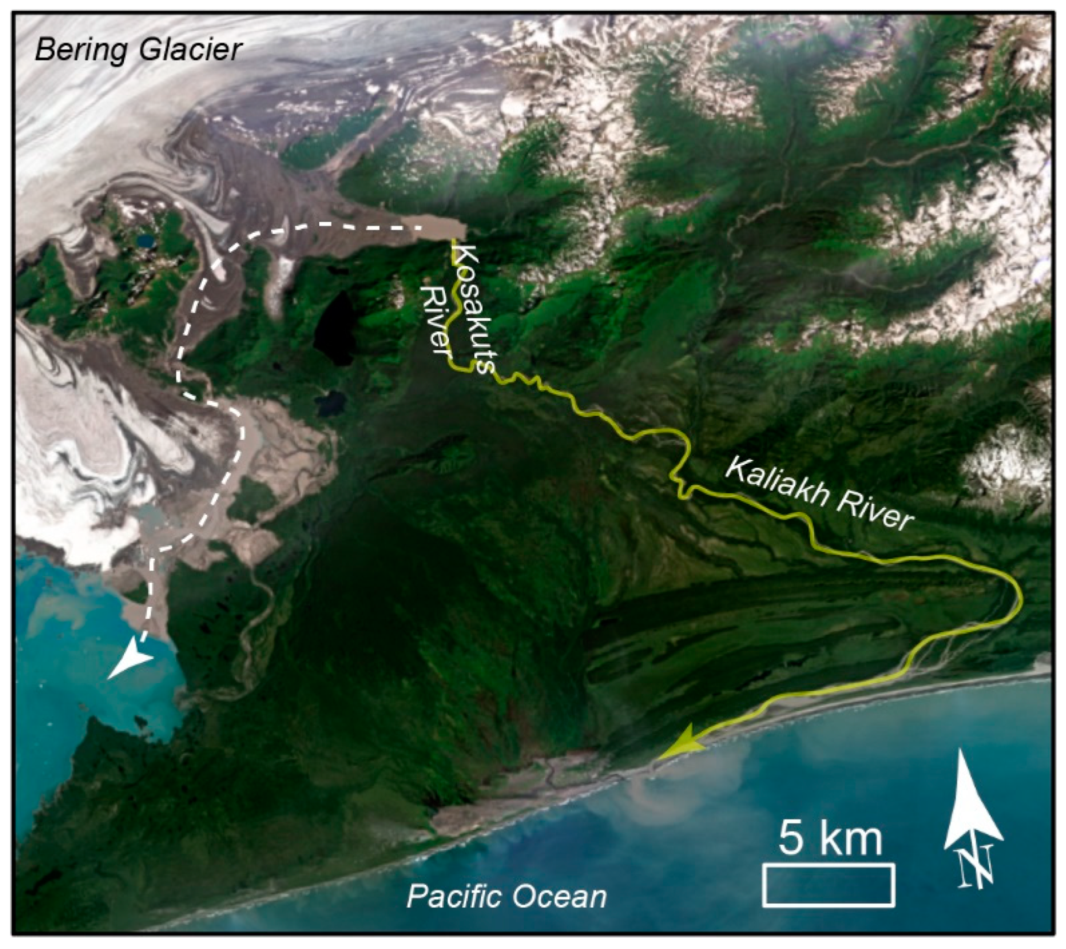
2.2.1. Bering Glacier, Alaska
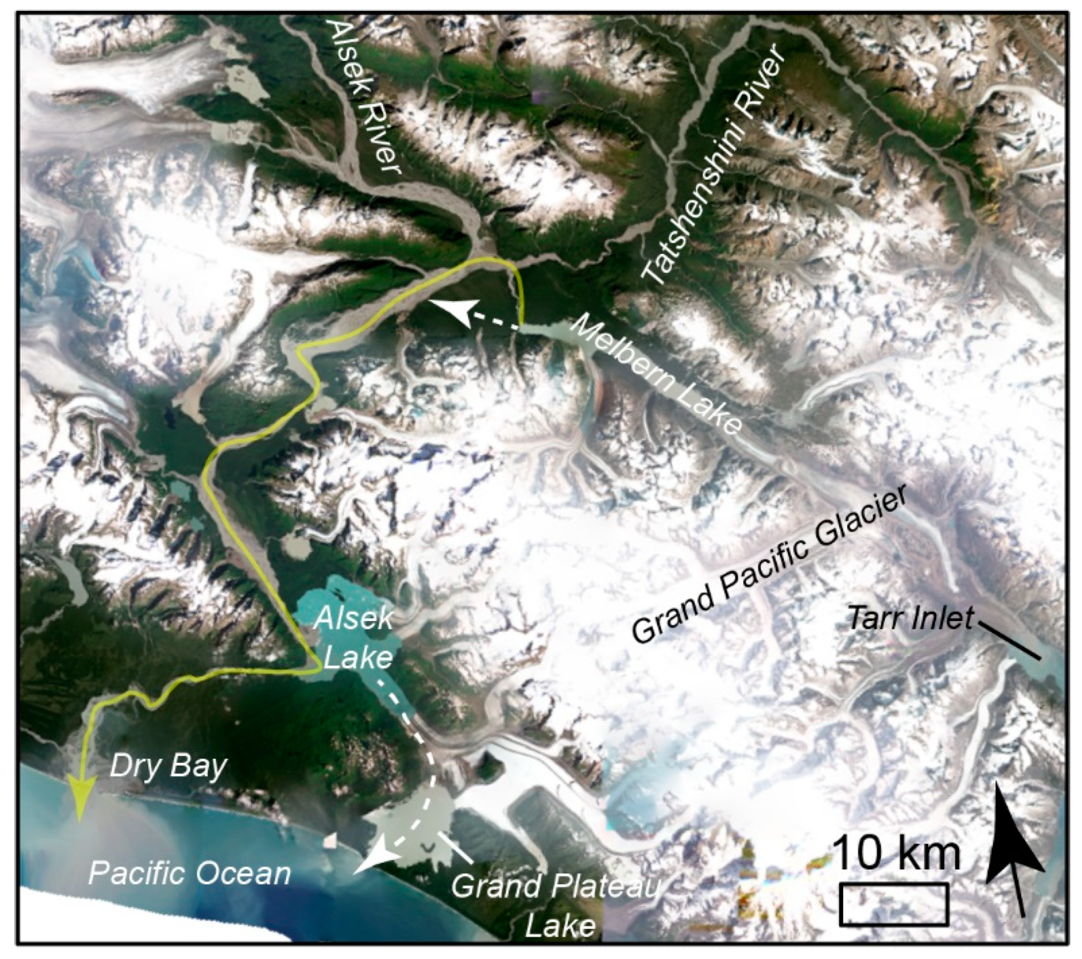
2.2.2. Grand Pacific and Melbern Glaciers, BC
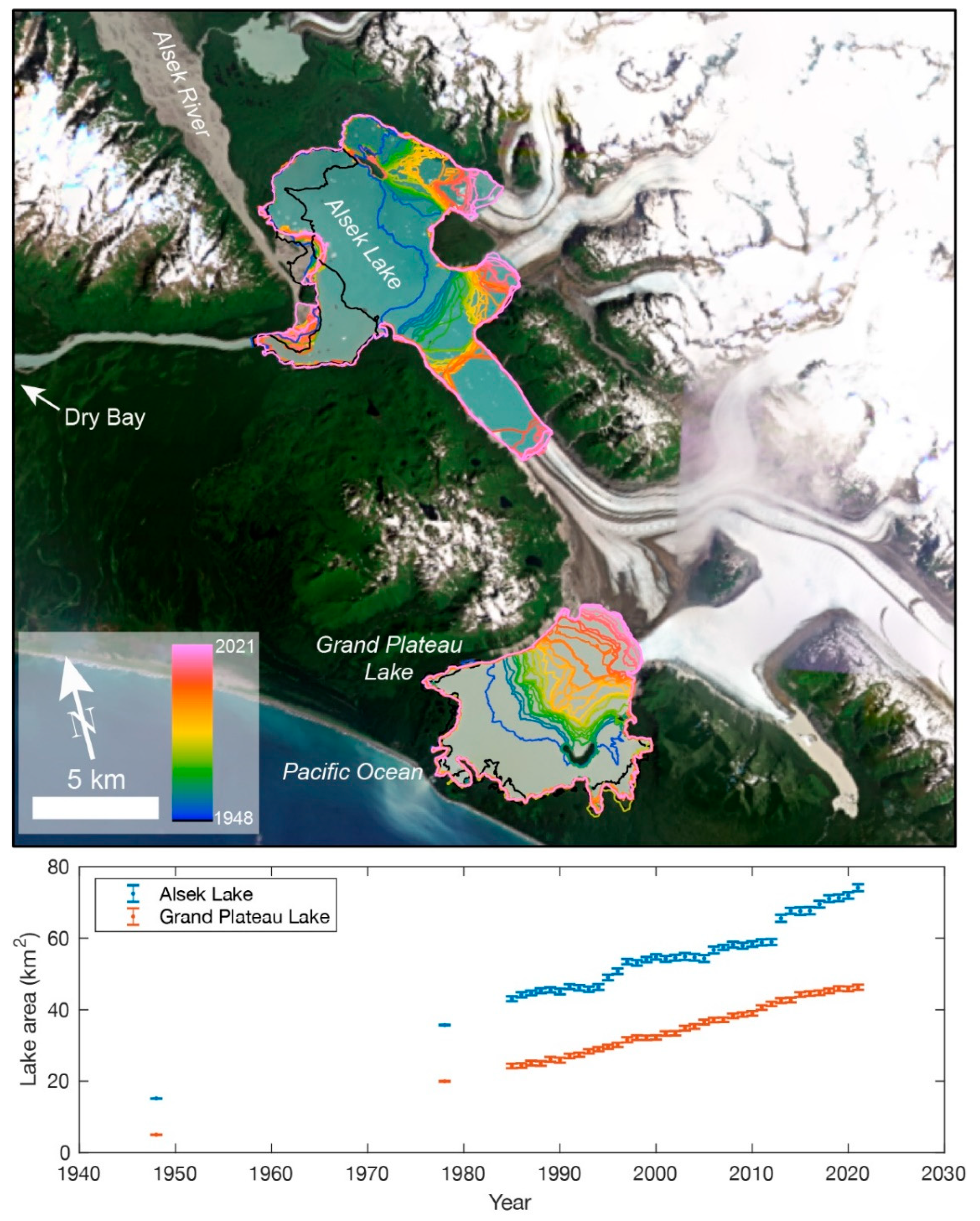
2.2.3. Alsek Lake and Grand Plateau Glacier, Alaska
3. Impacts of Deglacierization on Sediment Delivery and Hydrology
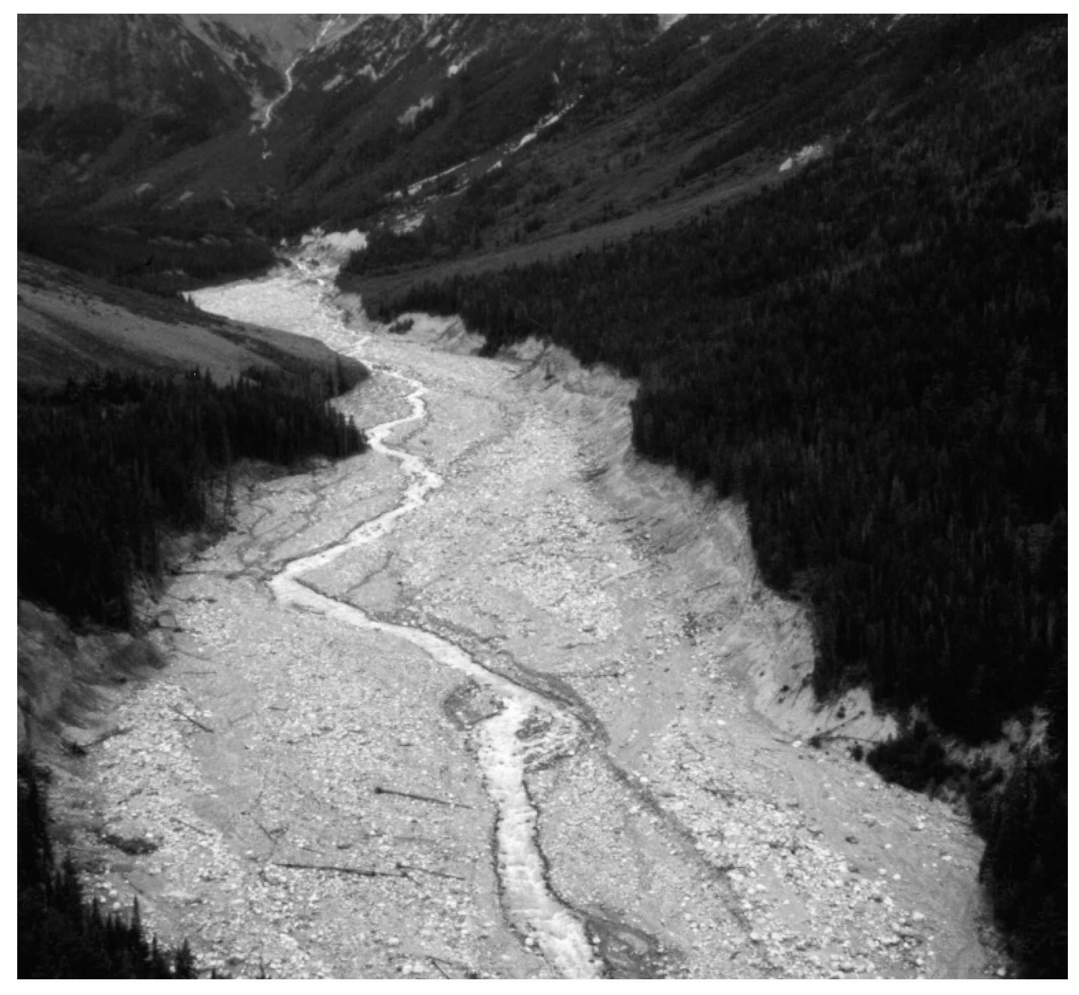
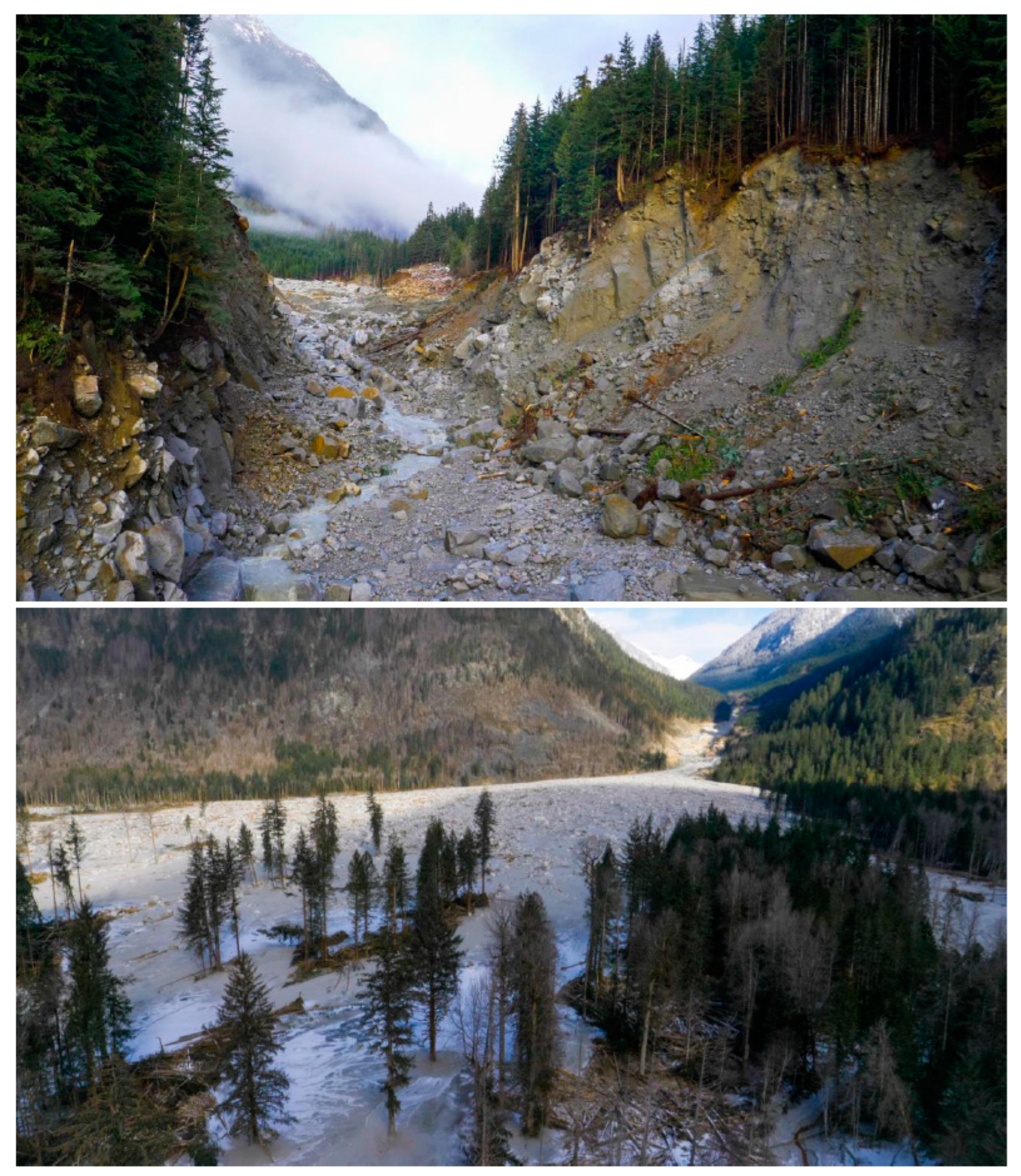
4. Impacts of Deglacierization on Ecosystems
5. Conclusions
Author Contributions
Funding
Data Availability Statement
Conflicts of Interest
References
- Bosson, J.; Huss, M.; Osipova, E. Disappearing world heritage glaciers as a keystone of nature conservation in a changing climate. Earth’s Future 2019, 7, 469–479. [Google Scholar] [CrossRef] [Green Version]
- Huss, M.; Bookhagen, B.; Huggel, C.; Jacobsen, D.; Bradley, R.; Clague, J.; Vuille, M.; Buytaert, W.; Cayan, D.; Greenwood, G.; et al. Toward mountains without permanent snow and ice. Earth’s Future. 2017, 5, 418–435. [Google Scholar] [CrossRef]
- Shugar, D.H.; Clague, J.J. Changing glaciers, changing rivers. In State of the Mountains Report 1; Parrott, L., Robinson, Z., Hik, D., Eds.; Alpine Club of Canada: Calgary, AB, Canada, 2018; pp. 4–11. ISBN 9780920330715. [Google Scholar]
- Vaughan, D.G.; Comiso, J.C.; Allison, I.; Carrasco, J.; Kaser, G.; Kwok, R.; Mote, P.W.; Murray, T.; Paul, F.; Ren, J.; et al. Observations: Cryosphere. In Climate Change 2013: The Physical Science Basis. Contribution of Working Group I to the Fifth Assessment Report of the Intergovernmental Panel on Climate Change; Stocker, T.F., Qin, D., Plattner, G.-K., Tignor, M., Allen, S.K., Boschung, J., Nauels, A., Xia, Y., Bex, V., Midgley, P.M., Eds.; Cambridge University Press: Cambridge, UK; New York, NY, USA, 2014; pp. 317–382. ISBN 9781107415324. [Google Scholar]
- Berthier, E.; Schiefer, E.; Clarke, G.K.C.; Menounos, B.; Remy, F. Contribution of Alaskan glaciers to sea-level rise derived from satellite imagery. Nat. Geosci. 2010, 3, 92–95. [Google Scholar] [CrossRef] [Green Version]
- Evans, S.G.; Clague, J.J. Recent climatic change and catastrophic geomorphic processes in mountain environments. Geomorphology 1994, 10, 107–128. [Google Scholar] [CrossRef]
- Larsen, C.F.; Motyka, R.J.; Arendt, A.A.; Echelmeyer, K.A.; Geissler, P.E. Glacier changes in southeast Alaska and northwest British Columbia and contribution to sea level rise. J. Geophys. Res. 2007, 112, F01007. [Google Scholar] [CrossRef]
- Dyke, A.S.; Prest, V.K. Late Wisconsinan and Holocene Retreat of the Laurentide Ice Sheet; Geological Survey of Canada: Ottawa, ON, Canada, 1987; Map 1702A; p. 1. [Google Scholar]
- Clarke, G.K.C.; Jarosch, A.H.; Anslow, F.S.; Radić, V.; Menounos, B. Projected deglaciation of western Canada in the twenty-first century. Nat. Geosci. 2015, 8, 372–377. [Google Scholar] [CrossRef]
- Hugonnet, R.; McNabb, R.; Berthier, E.; Menounos, B.; Nuth, C.; Girod, L.; Farinotti, D.; Huss, M.; Dussaillant, I.; Brun, F.; et al. Accelerated global glacier mass loss in the early twenty-first century. Nature 2021, 592, 726–731. [Google Scholar] [CrossRef]
- Shannon, S.; Smith, R.; Wiltshire, A.; Payne, T.; Huss, M.; Betts, R.; Caesar, J.; Koutroulis, A.; Jones, D.; Harrison, S. Global glacier volume projections under high-end climate change scenarios. Cryosphere 2019, 13, 325–350. [Google Scholar] [CrossRef] [Green Version]
- Harrison, S. Climate sensitivity: Implications for the response of geomorphological systems to future climate change. In Periglacial and Paraglacial Processes and Environments; Knight, J., Harrison, S., Eds.; Geological Society: London, UK, 2009; Special Publication 320; pp. 257–265. ISBN 9781862392816. [Google Scholar]
- Lane, S.N.; Bakker, M.; Gabbud, C.; Micheletti, N.; Saugy, J.-N. Sediment export, transient landscape response and catchment-scale connectivity following rapid climate warming and Alpine glacier recession. Geomorphology 2017, 277, 210–227. [Google Scholar] [CrossRef] [Green Version]
- Micheletti, N.; Chandler, J.H.; Lane, S.N. Investigating the geomorphological potential of freely available and accessible structure-from-motion photogrammetry using a smartphone. Earth Surf. Process. Landforms 2015, 40, 473–486. [Google Scholar] [CrossRef]
- Zhao, D.; Wu, S. Projected Changes in permafrost active layer thickness over the Qinghai-Tibet Plateau under climate change. Water Resour. Res. 2019, 55, 7860–7875. [Google Scholar] [CrossRef]
- Coe, J.A.; Bessette-Kirton, E.K.; Geertsema, M. Increasing rock-avalanche size and mobility in Glacier Bay National Park and Preserve, Alaska detected from 1984 to 2016 Landsat imagery. Landslides 2018, 15, 393–407. [Google Scholar] [CrossRef] [Green Version]
- Draebing, D.; Krautblatter, M. The efficacy of frost weathering processes in alpine rockwalls. Geophys. Res. Lett. 2019, 46, 6516–6524. [Google Scholar] [CrossRef]
- Drewes, J.; Moreiras, S.; Korup, O. Permafrost activity and atmospheric warming in the Argentinian Andes. Geomorphology 2018, 323, 13–24. [Google Scholar] [CrossRef]
- Gądek, B.; Grabiec, M.; Kędzia, S.; Rączkowska, Z. Reflection of climate changes in the structure and morphodynamics of talus slopes (the Tatra Mountains, Poland). Geomorphology 2016, 263, 39–49. [Google Scholar] [CrossRef]
- Geertsema, M.; Clague, J.J.; Schwab, J.W.; Evans, S.G. An overview of recent large catastrophic landslides in northern British Columbia, Canada. Eng. Geol. 2006, 83, 120–143. [Google Scholar] [CrossRef]
- Gruber, S.; Hoelzle, M.; Haeberli, W. Permafrost thaw and destabilization of Alpine rock walls in the hot summer of 2003. Geophys. Res. Lett. 2004, 31, L13504. [Google Scholar] [CrossRef] [Green Version]
- Gruber, S.; Haeberli, W. Permafrost in steep bedrock slopes and its temperature-related destabilization following climate change. J. Geophys. Res. Earth Surf. 2007, 112, 10. [Google Scholar] [CrossRef] [Green Version]
- Haeberli, W.; Schaub, Y.; Huggel, C. Increasing risks related to landslides from degrading permafrost into new lakes in de-glaciating mountain ranges. Geomorphology 2017, 293, 405–417. [Google Scholar] [CrossRef]
- Knight, J.; Harrison, S. Mountain glacial and paraglacial environments under global climate change: Lessons from the past, future directions and policy implications. Geogr. Ann. Ser. A Phys. Geogr. 2014, 96, 245–264. [Google Scholar] [CrossRef]
- Marshall, J.A.; Roering, J.J.; Gavin, D.G.; Granger, D.E. Late Quaternary climatic controls on erosion rates and geomorphic processes in western Oregon, USA. GSA Bull. 2017, 129, 715–731. [Google Scholar] [CrossRef]
- Patton, A.I.; Rathburn, S.L.; Capps, D.M. Landslide response to climate change in permafrost regions. Geomorphology 2019, 340, 116–128. [Google Scholar] [CrossRef]
- Stoffel, M.; Huggel, C. Effects of climate change on mass movements in mountain environments. Prog. Phys. Geogr. Earth Environ. 2012, 36, 421–439. [Google Scholar] [CrossRef]
- Clague, J.J.; O’Connor, J.E. Glacier-related outburst floods. In Snow and Ice-Related Hazards, Risks, and Disasters; Haeberli, W., Whiteman, C., Eds.; Elsevier: Amsterdam, The Netherlands, 2021; pp. 467–499. ISBN 9780128171295. [Google Scholar]
- O’Connor, J.E.; Clague, J.J.; Walder, J.S.; Manville, V.; Beebee, R.A. 6.36 – Outburst floods. In Treatise on Geomorphology, 2nd ed.; Shroder, J.F., Ed.; Academic: Oxford, UK, 2022; ISBN 9780128182345. [Google Scholar]
- Duethmann, D.; Bolch, T.; Farinotti, D.; Kriegel, D.; Vorogushyn, S.; Merz, B.; Pieczonka, T.; Jiang, T.; Su, B.; Güntner, A. Attribution of streamflow trends in snow and glacier melt-dominated catchments of the Tarim River, Central Asia. Water Resour. Res. 2015, 51, 4727–4750. [Google Scholar] [CrossRef] [Green Version]
- East, A.E.; Sankey, J.B. Geomorphic and sedimentary effects of modern climate change: Current and anticipated future conditions in the western United States. Rev. Geophys. 2020, 58, e2019RG000692. [Google Scholar] [CrossRef]
- Farinotti, D.; Longuevergne, L.; Moholdt, G.; Duethmann, D.; Mölg, T.; Bolch, T.; Vorogushyn, S.; Güntner, A. Substantial glacier mass loss in the Tien Shan over the past 50 years. Nat. Geosci. 2015, 8, 716–722. [Google Scholar] [CrossRef]
- Leach, J.A.; Moore, R.D. Empirical stream thermal sensitivities may underestimate stream temperature response to climate warming. Water Resour. Res. 2019, 55, 5453–5467. [Google Scholar] [CrossRef]
- Mantua, N.; Tohver, I.; Hamlet, A. Climate change impacts on streamflow extremes and summertime stream temperature and their possible consequences for freshwater salmon habitat in Washington State. Clim. Change 2010, 102, 187–223. [Google Scholar] [CrossRef]
- Mantua, N.J.; Crozier, L.G.; Reed, T.E.; Schindler, D.E.; Waples, R.S. Response of chinook salmon to climate change. Nat. Clim. Change 2015, 5, 613–615. [Google Scholar] [CrossRef]
- Milner, A.M.; Brown, L.E.; Hannah, D.M. Hydroecological response of river systems to shrinking glaciers. Hydrol. Process. 2009, 23, 62–77. [Google Scholar] [CrossRef]
- Milner, A.M.; Khamis, K.; Battin, T.J.; Brittain, J.E.; Barrand, N.; Füreder, L.; Cauvy-Fraunié, S.; Gislason, G.M.; Jacobsen, D.; Hannah, D.; et al. Glacier shrinkage driving global changes in downstream systems. Proc. Natl. Acad. Sci. USA 2017, 114, 9770–9778. [Google Scholar] [CrossRef] [PubMed] [Green Version]
- Muñoz, N.J.; Farrell, A.P.; Heath, J.W.; Neff, B.D. Adaptive potential of a Pacific salmon challenged by climate change. Nat. Clim. Change 2015, 5, 163–166. [Google Scholar] [CrossRef]
- Vuille, M.; Carey, M.; Huggel, C.; Buytaert, W.; Rabatel, A.; Jacobsen, D.; Soruco, A.; Villacis, M.; Yarleque, C.; Timm, O.E.; et al. Rapid decline of snow and ice in the tropical Andes—Impacts, uncertainties and challenges ahead. Earth-Sci. Rev. 2018, 176, 195–213. [Google Scholar] [CrossRef] [Green Version]
- Wade, A.A.; Beechie, T.J.; Fleishman, E.; Mantua, N.J.; Wu, H.; Kimball, J.S.; Stoms, D.M.; Stanford, J.A. Steelhead vulnerability to climate change in the Pacific Northwest. J. Appl. Ecol. 2013, 50, 1093–1104. [Google Scholar] [CrossRef]
- Pitman, K.J.; Moore, J.W.; Huss, M.; Sloat, M.R.; Whited, D.C.; Beechie, T.J.; Brenner, R.; Hood, E.W.; Milner, A.M.; Pess, G.R.; et al. Glacier retreat creating new Pacific salmon habitat in western North America. Nat. Commun. 2021, 12, 6816. [Google Scholar] [CrossRef] [PubMed]
- Pitman, K.J.; Moore, J.W.; Sloat, M.R.; Beaudreau, A.H.; Bidlack, A.L.; Brenner, R.E.; Hood, E.W.; Pess, G.R.; Mantua, N.J.; Milner, A.M.; et al. Glacier retreat and Pacific salmon. Bioscience 2020, 70, 220–236. [Google Scholar] [CrossRef] [Green Version]
- Duk-Rodkin, A.; Barendregt, R.; White, J.; Singhroy, V. Geologic evolution of the Yukon River: Implications for placer gold. Quat. Int. 2001, 82, 5–31. [Google Scholar] [CrossRef]
- Ryan, J.J.; Hayward, N.; Jackson, L.E. Landscape antiquity and Cenozoic drainage development of southern Yukon, through restoration modeling of the Tintina Fault. Can. J. Earth Sci. 2017, 54, 1085–1100. [Google Scholar] [CrossRef] [Green Version]
- Tempelman-Kluit, D. Evolution of physiography and drainage in southern Yukon. Can. J. Earth Sci. 1980, 17, 1189–1203. [Google Scholar] [CrossRef]
- Andrews, G.D.; Russell, J.K.; Brown, S.R.; Enkin, R.J. Pleistocene reversal of the Fraser River, British Columbia. Geology 2012, 40, 111–114. [Google Scholar] [CrossRef]
- RGI Consortium. Randolph Glacier Inventory—A Dataset of Global Glacier Outlines: Version 5.0 [Data Set]; National Snow and Ice Data Center: Boulder, CO, USA, 2015. [Google Scholar] [CrossRef]
- Shugar, D.H.; Clague, J.J.; Best, J.L.; Schoof, C.; Willis, M.J.; Copland, L.; Roe, G.H. River piracy and drainage basin reorganization led by climate-driven glacier retreat. Nat. Geosci. 2017, 10, 370–375. [Google Scholar] [CrossRef]
- Zabel, N.A.; Hall, R.I.; Branfireun, B.A.; Swanson, H.K. Mercury accumulation in sediments of Lhù’ààn Mân’ (Kluane Lake, YT): Response to past hydrological change. Arctic, Antarct. Alp. Res. 2021, 53, 179–195. [Google Scholar] [CrossRef]
- Bachelder, J.; Cadieux, M.; Liu-Kang, C.; Lambert, P.; Filoche, A.; Galhardi, J.A.; Hadioui, M.; Chaput, A.; Bastien-Thibault, M.-P.; Wilkinson, K.J.; et al. Chemical and microphysical properties of wind-blown dust near an actively retreating glacier in Yukon, Canada. Aerosol Sci. Technol. 2020, 54, 2–20. [Google Scholar] [CrossRef]
- McKnight, E. Characterizing and monitoring the water properties and dynamics of Lhù’ààn Mǟn (Kluane Lake), Yukon, in the face of climate change. Arctic 2017, 70, 435–440. [Google Scholar] [CrossRef] [Green Version]
- McKnight, E.A.; Swanson, H.; Brahney, J.; Hik, D.S. The physical and chemical limnology of Yukon’s largest lake, Lhù’ààn Mân’ (Kluane Lake), prior to the 2016 ‘A’äy Chù’ diversion. Arct. Sci. 2021, 7, 655–678. [Google Scholar] [CrossRef]
- Clague, J.J.; Evans, S.G. Historic retreat of Grand Pacific and Melbern glaciers Saint Elias Mountains, Canada: An analogue for decay of the Cordilleran ice sheet at the end of the Pleistocene? J. Glaciol. 1993, 39, 619–624. [Google Scholar] [CrossRef] [Green Version]
- Farinotti, D.; Huss, M.; Fürst, J.J.; Landmann, J.; Machguth, H.; Maussion, F.; Pandit, A. A consensus estimate for the ice thickness distribution of all glaciers on Earth. Nat. Geosci. 2019, 12, 168–173. [Google Scholar] [CrossRef] [Green Version]
- Loso, M.G.; Larsen, C.F.; Tober, B.S.; Christoffersen, M.; Fahnestock, M.; Holt, J.W.; Truffer, M. Quo vadis, Alsek? Climate-driven glacier retreat may change the course of a major river outlet in southern Alaska. Geomorphology 2021, 384, 107701. [Google Scholar] [CrossRef]
- Pelto, M. Grand Plateau Glacier retreat, Alaska. AGU Advancing Earth and Space Science Blogosphere. Available online: http://blogs.agu.org/fromaglaciersperspective/2011/02/04/grand-plateau-glacier-retreat/ (accessed on 7 December 2022).
- Pelto, M. North Fork Grand Plateau Glacier, Alaska—Spectacular 3 km Retreat 2013-15. AGU Advancing Earth and Space Science Blogosphere. Available online: http://blogs.agu.org/fromaglaciersperspective/2016/05/01/south-fork-alsek-glacier-alaska-spectacular-3-km-retreat-2013-15/ (accessed on 7 December 2022).
- Haritashya, U.K.; Kargel, J.S.; Shugar, D.H.; Leonard, G.J.; Strattman, K.; Watson, C.S.; Shean, D.; Harrison, S.; Mandli, K.T.; Regmi, D. Evolution and controls of large glacial lakes in the Nepal Himalaya. Remote. Sens. 2018, 10, 798. [Google Scholar] [CrossRef]
- Anderson, S.; Radić, V. Identification of local water resource vulnerability to rapid deglaciation in Alberta. Nat. Clim. Change. 2020, 10, 933–938. [Google Scholar] [CrossRef]
- Birsan, M.-V.; Molnar, P.; Burlando, P.; Pfaundler, M. Streamflow trends in Switzerland. J. Hydrol. 2005, 314, 312–329. [Google Scholar] [CrossRef]
- Chesnokova, A.; Baraër, M.; Laperrière-Robillard, T.; Huh, K. Linking mountain glacier retreat and hydrological changes in southwestern Yukon. Water Resour. Res. 2020, 56, e2019WR025706. [Google Scholar] [CrossRef]
- Frans, C.; Istanbulluoglu, E.; Lettenmaier, D.P.; Fountain, A.G.; Riedel, J. Glacier Recession and the Response of Summer Streamflow in the Pacific Northwest United States, 1960–2099. Water Resour. Res. 2018, 54, 6202–6225. [Google Scholar] [CrossRef] [Green Version]
- Kormos, P.R.; Luce, C.H.; Wenger, S.J.; Berghuijs, W.R. Trends and sensitivities of low streamflow extremes to discharge timing and magnitude in Pacific Northwest mountain streams. Water Resour. Res. 2016, 52, 4990–5007. [Google Scholar] [CrossRef] [Green Version]
- Lane, S.N.; Nienow, P.W. Decadal scale climate forcing of alpine glacial hydrological systems. Water Resour. Res. 2019, 55, 2478–2492. [Google Scholar] [CrossRef] [Green Version]
- Micheletti, N.; Lane, S.N. Water yield and sediment export in small, partially glaciated Alpine watersheds in a warming climate. Water Resour. Res. 2016, 52, 4924–4943. [Google Scholar] [CrossRef] [Green Version]
- Stewart, I.T. Changes in snowpack and snowmelt runoff for key mountain regions. Hydrol. Process. 2009, 23, 78–94. [Google Scholar] [CrossRef]
- Stewart, I.T.; Cayan, D.R.; Dettinger, M.D. Changes toward earlier streamflow timing across western North America. J. Clim. 2005, 18, 1136–1155. [Google Scholar] [CrossRef]
- Stumbaugh, M.; Hamlet, A.F. Effects of climate change on extreme low-flows in small lowland tributaries in the Skagit River basin. Northwest Sci. 2016, 90, 44–56. [Google Scholar] [CrossRef]
- Beamer, J.P.; Hill, D.F.; McGrath, D.; Arendt, A.; Kienholz, C. Hydrologic impacts of changes in climate and glacier extent in the Gulf of Alaska watershed. Water Resour. Res. 2017, 53, 7502–7520. [Google Scholar] [CrossRef]
- Hallet, B.; Hunter, L.; Bogen, J. Rates of erosion and sediment evacuation by glaciers: A review of field data and their implications. Glob. Planet. Change 1996, 12, 213–235. [Google Scholar] [CrossRef]
- Koppes, M.N.; Montgomery, D.R. The relative efficacy of fluvial and glacial erosion over modern to orogenic timescales. Nat. Geosci. 2009, 2, 644–647. [Google Scholar] [CrossRef]
- Lawson, D.E. Glaciologic and Glaciohydraulic Effects on Runoff and Sediment Yield in Glacierized Basins; U.S. Army Corp of Engineers, Cold Regions Research Laboratory: Hanover, NH, USA, 1993; Technical Report AD-A275 134. [Google Scholar]
- Fischer, L.; Huggel, C.; Kääb, A.; Haeberli, W. Slope failures and erosion rates on a glacierized high-mountain face under climatic changes. Earth Surf. Process. Landforms 2013, 38, 836–846. [Google Scholar] [CrossRef]
- Geertsema, M.; Menounos, B.; Bullard, G.; Carrivick, J.L.; Clague, J.J.; Dai, C.; Donati, D.; Ekstrom, G.; Jackson, J.M.; Lynett, P.; et al. The 28 November 2020 landslide, tsunami, and outburst flood—A hazard cascade associated with rapid deglaciation at Elliot Creek, British Columbia, Canada. Geophys. Res. Lett. 2022, 49, e2021GL096716. [Google Scholar] [CrossRef]
- Huggel, C.; Clague, J.J.; Korup, O. Is climate change responsible for changing landslide activity in high mountains? Earth Surf. Process. Landforms 2012, 37, 77–91. [Google Scholar] [CrossRef]
- Shugar, D.H.; Jacquemart, M.; Shean, D.; Bhushan, S.; Upadhyay, K.; Sattar, A.; Schwanghart, W.; McBride, S.; de Vries, M.V.W.; Mergili, M.; et al. A massive rock and ice avalanche caused the 2021 disaster at Chamoli, Indian Himalaya. Science 2021, 373, 300–306. [Google Scholar] [CrossRef]
- Tunnicliffe, J.; Church, M.; Enkin, R.J. Postglacial sediment yield to Chilliwack Lake, British Columbia, Canada. Boreas 2012, 41, 84–101. [Google Scholar] [CrossRef]
- Wohl, E.; Brierley, G.; Cadol, D.; Coulthard, T.J.; Covino, T.; Fryirs, K.A.; Grant, G.; Hilton, R.G.; Lane, S.N.; Magilligan, F.J.; et al. Connectivity as an emergent property of geomorphic systems. Earth Surf. Process. Landforms 2019, 44, 4–26. [Google Scholar] [CrossRef] [Green Version]
- Ballantyne, C.K. Paraglacial geomorphology. Quat. Sci. Rev. 2002, 21, 1935–2017. [Google Scholar] [CrossRef]
- Tranmer, A.W.; Goodwin, P.; Caamaño, D. Assessment of alluvial trends toward dynamic equilibrium under chronic climatic forcing. Adv. Water Resour. 2018, 120, 19–34. [Google Scholar] [CrossRef]
- Li, D.; Lu, X.; Overeem, I.; Walling, D.E.; Syvitski, J.; Kettner, A.J.; Bookhagen, B.; Zhou, Y.; Zhang, T. Exceptional increases in fluvial sediment fluxes in a warmer and wetter High Mountain Asia. Science 2021, 374, 599–603. [Google Scholar] [CrossRef] [PubMed]
- Korup, O.; Tweed, F. Ice, moraine, and landslide dams in mountainous terrain. Quat. Sci. Rev. 2007, 26, 3406–3422. [Google Scholar] [CrossRef]
- Richardson, S.D.; Reynolds, J.M. Degradation of ice-cored moraine dams; implications for hazard development. In Debris-Covered Glaciers; Nakawo, M., Raymond, C.F., Fountain, A., Eds.; IAHS-AISH: Seattle, WA, USA, 2000; Publication 264; pp. 187–197. ISBN 1901502317. [Google Scholar]
- Stoffel, M.; Tiranti, D.; Huggel, C. Climate change impacts on mass movements—Case studies from the European Alps. Sci. Total Environ. 2014, 493, 1255–1266. [Google Scholar] [CrossRef] [PubMed]
- Harrison, S.; Kargel, J.S.; Huggel, C.; Reynolds, J.; Shugar, D.H.; Betts, R.A.; Emmer, A.; Glasser, N.; Haritashya, U.K.; Klimeš, J.; et al. Climate change and the global pattern of moraine-dammed glacial lake outburst floods. Cryosphere 2018, 12, 1195–1209. [Google Scholar] [CrossRef] [Green Version]
- Shugar, D.H.; Burr, A.; Haritashya, U.K.; Kargel, J.S.; Watson, C.S.; Kennedy, M.C.; Bevington, A.R.; Betts, R.A.; Harrison, S.; Strattman, K. Rapid worldwide growth of glacial lakes since 1990. Nat. Clim. Change 2020, 10, 1–7. [Google Scholar] [CrossRef]
- Dussaillant, A.; Benito, G.; Buytaert, W.; Carling, P.; Meier, C.; Espinoza, F. Repeated glacial-lake outburst floods in Patagonia: An increasing hazard? Nat. Hazards 2010, 54, 469–481. [Google Scholar] [CrossRef] [Green Version]
- Church, M.; Ryder, J.M. Paraglacial sedimentation: A consideration of fluvial processes conditioned by glaciation. GSA Bull. 1972, 83, 3059–3072. [Google Scholar] [CrossRef] [Green Version]
- Dadson, S.J.; Church, M. Postglacial topographic evolution of glaciated valleys: A stochastic landscape evolution model. Earth Surf. Process. Landforms 2005, 30, 1387–1403. [Google Scholar] [CrossRef]
- Friele, P.A.; Clague, J.J. Paraglacial geomorphology of Quaternary volcanic landscapes in the southern Coast Mountains, British Columbia. In Periglacial and Paraglacial Processes and Environments; Knight, J., Harrison, S., Eds.; Geological Society: London, UK, 2009; Special Publication 320; pp. 219–233. ISBN 9781862392816. [Google Scholar]
- Koppes, M.; Sylwester, R.; Rivera, A.; Hallet, B. Variations in sediment yield over the advance and retreat of a calving glacier, Laguna San Rafael, North Patagonian Icefield. Quat. Res. 2010, 73, 84–95. [Google Scholar] [CrossRef]
- Stott, T.; Mount, N. Alpine proglacial suspended sediment dynamics in warm and cool ablation seasons: Implications for global warming. J. Hydrol. 2007, 332, 259–270. [Google Scholar] [CrossRef]
- Larsen, D.J.; Miller, G.H.; Geirsdóttir, Á.; Thordarson, T. A 3000-year varved record of glacier activity and climate change from the proglacial lake Hvítárvatn, Iceland. Quat. Sci. Rev. 2011, 30, 2715–2731. [Google Scholar] [CrossRef]
- Menounos, B.; Clague, J.J. Reconstructing hydro-climatic events and glacier fluctuations over the past millennium from annually laminated sediments of Cheakamus Lake, southern Coast Mountains, British Columbia, Canada. Quat. Sci. Rev. 2008, 27, 701–713. [Google Scholar] [CrossRef]
- Schiefer, E.; Hassan, M.A.; Menounos, B.; Pelpola, C.P.; Slaymaker, O. Interdecadal patterns of total sediment yield from a montane catchment, southern Coast Mountains, British Columbia, Canada. Geomorphology 2010, 118, 207–212. [Google Scholar] [CrossRef]
- Chew, L.; Ashmore, P. Channel adjustment and a test of rational regime theory in a proglacial braided stream. Geomorphology 2001, 37, 43–63. [Google Scholar] [CrossRef]
- Kershaw, J.A.; Clague, J.J.; Evans, S.G. Geomorphic and sedimentological signature of a two-phase outburst flood from moraine-dammed Queen Bess Lake, British Columbia, Canada. Earth Surf. Process. Landforms 2005, 30, 1–25. [Google Scholar] [CrossRef]
- Menounos, B.; Osborn, G.; Clague, J.J.; Luckman, B.H. Latest Pleistocene and Holocene glacier fluctuations in western Canada. Quat. Sci. Rev. 2009, 28, 2049–2074. [Google Scholar] [CrossRef]
- Koch, J.; Clague, J.J.; Osborn, G.D. Glacier fluctuations during the past millennium in Garibaldi Provincial Park, southern Coast Mountains, British Columbia. Can. J. Earth Sci. 2007, 44, 1215–1233. [Google Scholar] [CrossRef]
- Church, M. Pattern of Instability in a wandering gravel bed channel. In Modern and Ancient Fluvial Systems; Collinson, J.D., Lewin, J., Eds.; Blackwell Publishing Ltd.: Oxford, UK, 1983; pp. 169–180. ISBN 9780632009978. [Google Scholar]
- Gottesfeld, A.S.; Gottesfeld, L.M.J. Floodplain dynamics of a wandering river, dendrochronology of the Morice River, British Columbia, Canada. Geomorphology 1990, 3, 159–179. [Google Scholar] [CrossRef]
- Mark, B.G.; Baraer, M.; Fernandez, A.; Immerzeel, W.; Moore, R.D.; Weingartner, R. Glaciers as water resources. In The High-Mountain Cryosphere: Environmental Changes and Human Risks; Kääb, A., Huggel, C., Clague, J.J., Carey, M., Eds.; Cambridge University Press: Cambridge, UK, 2015; pp. 184–203. ISBN 978-1107662759. [Google Scholar]
- Moore, R.D.; Fleming, S.W.; Menounos, B.; Wheate, R.; Fountain, A.; Stahl, K.; Holm, K.; Jakob, M. Glacier change in western North America: Influences on hydrology, geomorphic hazards and water quality. Hydrol. Process. 2009, 23, 42–61. [Google Scholar] [CrossRef]
- Baraer, M.; Mark, B.G.; McKenzie, J.M.; Condom, T.; Bury, J.; Huh, K.-I.; Portocarrero, C.; Gómez, J.; Rathay, S. Glacier recession and water resources in Peru’s Cordillera Blanca. J. Glaciol. 2012, 58, 134–150. [Google Scholar] [CrossRef] [Green Version]
- Bliss, A.; Hock, R.; Radić, V. Global response of glacier runoff to twenty-first century climate change. J. Geophys. Res. Earth Surf. 2014, 119, 717–730. [Google Scholar] [CrossRef]
- Farinotti, D.; Usselmann, S.; Huss, M.; Bauder, A.; Funk, M. Runoff evolution in the Swiss Alps: Projections for selected high-alpine catchments based on ENSEMBLES scenarios. Hydrol. Process. 2012, 26, 1909–1924. [Google Scholar] [CrossRef]
- Frans, C.; Istanbulluoglu, E.; Lettenmaier, D.P.; Clarke, G.; Bohn, T.J.; Stumbaugh, M. Implications of decadal to century scale glacio-hydrological change for water resources of the Hood River basin, OR, USA. Hydrol. Process. 2016, 30, 4314–4329. [Google Scholar] [CrossRef]
- Immerzeel, W.W.; Pellicciotti, F.; Bierkens, M.F.P. Rising river flows throughout the twenty-first century in two Himalayan glacierized watersheds. Nat. Geosci. 2013, 6, 742–745. [Google Scholar] [CrossRef]
- Lutz, A.; Immerzeel, W.; Shrestha, A.B.; Bierkens, M.F. Consistent increase in High Asia’s runoff due to increasing glacier melt and precipitation. Nat. Clim. Change. 2014, 4, 587–592. [Google Scholar] [CrossRef] [Green Version]
- Ragettli, S.; Immerzeel, W.W.; Pellicciotti, F. Contrasting climate change impact on river flows from high-altitude catchments in the Himalayan and Andes Mountains. Proc. Natl. Acad. Sci. USA 2016, 113, 9222–9227. [Google Scholar] [CrossRef] [Green Version]
- Biemans, H.; Siderius, C.; Lutz, A.F.; Nepal, S.; Ahmad, B.; Hassan, T.; Von Bloh, W.; Wijngaard, R.R.; Wester, P.; Shrestha, A.B.; et al. Importance of snow and glacier meltwater for agriculture on the Indo-Gangetic Plain. Nat. Sustain. 2019, 2, 594–601. [Google Scholar] [CrossRef] [Green Version]
- Immerzeel, W.W.; Van Beek, L.P.H.; Bierkens, M.F.P. Climate change will affect the Asian Water Towers. Science 2010, 328, 1382–1385. [Google Scholar] [CrossRef]
- Viviroli, D.; Archer, D.R.; Buytaert, W.; Fowler, H.J.; Greenwood, G.B.; Hamlet, A.F.; Huang, Y.; Koboltschnig, G.; Litaor, M.I.; López-Moreno, J.I.; et al. Climate change and mountain water resources: Overview and recommendations for research, management and policy. Hydrol. Earth Syst. Sci. 2011, 15, 471–504. [Google Scholar] [CrossRef]
- Xu, J.; Grumbine, R.E.; Shrestha, A.; Eriksson, M.; Yang, X.; Wang, Y.; Wilkes, A. The melting Himalayas: Cascading effects of climate change on water, biodiversity, and livelihoods. Conserv. Biol. 2009, 23, 520–530. [Google Scholar] [CrossRef]
- Barreiro-Lostres, F.; Moreno, A.; González-Sampériz, P.; Giralt, S.; Nadal-Romero, E.; Valero-Garcés, B. Erosion in Mediterranean mountain landscapes during the last millennium: A quantitative approach based on lake sediment sequences (Iberian Range, Spain). Catena 2017, 149, 782–798. [Google Scholar] [CrossRef]
- Pelletier, J.D.; Murray, A.B.; Pierce, J.L.; Bierman, P.R.; Breshears, D.D.; Crosby, B.T.; Ellis, M.; Foufoula-Georgiou, E.; Heimsath, A.M.; Houser, C.; et al. Forecasting the response of Earth’s surface to future climatic and land use changes: A review of methods and research needs. Earth’s Future. 2015, 3, 220–251. [Google Scholar] [CrossRef] [Green Version]
- Reinhardt, L.; Jerolmack, D.; Cardinale, B.J.; Vanacker, V.; Wright, J. Dynamic interactions of life and its landscape: Feedbacks at the interface of geomorphology and ecology. Earth Surf. Process. Landforms 2010, 35, 78–101. [Google Scholar] [CrossRef]
- Werner, C.; Schmid, M.; Ehlers, T.A.; Fuentes-Espoz, J.P.; Steinkamp, J.; Forrest, M.; Liakka, J.; Maldonado, A.; Hickler, T. Effect of changing vegetation and precipitation on denudation—Part 1: Predicted vegetation composition and cover over the last 21 thousand years along the Coastal Cordillera of Chile. Earth Surf. Dyn. 2018, 6, 829–858. [Google Scholar] [CrossRef] [Green Version]
- Yetemen, O.; Saco, P.M.; Istanbulluoglu, E. Ecohydrology controls the geomorphic response to climate change. Geophys. Res. Lett. 2019, 46, 8852–8861. [Google Scholar] [CrossRef]
- Corenblit, D.; Davies, N.S.; Steiger, J.; Gibling, M.R.; Bornette, G. Considering river structure and stability in the light of evolution: Feedbacks between riparian vegetation and hydrogeomorphology. Earth Surf. Process. Landforms 2015, 40, 189–207. [Google Scholar] [CrossRef] [Green Version]
- Gurnell, A. Plants as river system engineers. Earth Surf. Process. Landfoms 2014, 39, 4–25. [Google Scholar] [CrossRef]
- Ielpi, A.; Lapôtre, M.G.A. A tenfold slowdown in river meander migration driven by plant life. Nat. Geosci. 2020, 13, 82–86. [Google Scholar] [CrossRef]
- Beeson, H.W.; Flitcroft, R.L.; Fonstad, M.A.; Roering, J.J. Deep-seated landslides drive variability in valley width and increase connectivity of salmon habitat in the Oregon Coast Range. JAWRA J. Am. Water Resour. Assoc. 2018, 54, 1325–1340. [Google Scholar] [CrossRef]
- Death, R.G.; Fuller, I.; Macklin, M.G. Resetting the river template: The potential for climate-related extreme floods to transform river geomorphology and ecology. Freshw. Biol. 2015, 60, 2477–2496. [Google Scholar] [CrossRef]
- Jansson, P.; Hock, R.; Schneider, T. The concept of glacier storage: A review. J. Hydrol. 2003, 282, 116–129. [Google Scholar] [CrossRef]
- Milner, A.M. Glacial recession and freshwater ecosystems in coastal Alaska. In Freshwaters of Alaska, Ecological Syntheses; Milner, A.M., Oswood, M.W., Eds.; Springer: New York, NY, USA, 1997; Ecological Studies 119; pp. 303–330. ISBN 9781461206774. [Google Scholar]
- Milner, A.M.; Robertson, A.; Brown, L.; Sønderland, S.H.; McDermott, M.; Veal, A.J. Evolution of a stream ecosystem in recently deglaciated terrain. Ecology 2011, 92, 1924–1935. [Google Scholar] [CrossRef] [PubMed]
- O’Neel, S.; Hood, E.; Arendt, A.; Sass, L. Assessing streamflow sensitivity to variations in glacier mass balance. Clim. Change. 2014, 123, 329–341. [Google Scholar] [CrossRef] [Green Version]
- Stahl, K.; Moore, R.D.; Shea, J.; Hutchinson, D.; Cannon, A. Coupled modelling of glacier and streamflow response to future climate scenarios. Water Resour. Res. 2008, 44, W02422. [Google Scholar] [CrossRef] [Green Version]
- Brown, L.E.; Hannah, D.M. Spatial heterogeneity of water temperature across an alpine river basin. Hydrol. Process. 2008, 22, 954–967. [Google Scholar] [CrossRef]
- Fleming, S.W.; Clarke, G.K. Attenuation of high-frequency interannual streamflow variability by watershed glacial cover. J. Hydraul. Eng. 2005, 131, 615–618. [Google Scholar] [CrossRef]
- Gottfried, M.; Pauli, H.; Futschik, A.; Akhalkatsi, M.; Barančok, P.; Benito Alonso, J.L.; Coldea, G.; Dick, J.; Erschbamer, B.; Fernández Calzado, M.R.; et al. Continent-wide response of mountain vegetation to climate change. Nat. Clim. Change. 2012, 2, 111–115. [Google Scholar] [CrossRef]
- Jacobsen, D.; Cauvy-Fraunie, S.; Andino, P.; Espinosa, R.; Cueva, D.; Dangles, O. Runoff and the longitudinal distribution of macroinvertebrates in a glacier-fed stream: Implications for the effects of global warming. Freshw. Biol. 2014, 59, 2038–2050. [Google Scholar] [CrossRef]
- Brown, L.E.; Milner, A.M. Rapid loss of glacial ice reveals stream community assembly processes. Glob. Change. Biol. 2012, 18, 2195–2204. [Google Scholar] [CrossRef]
- Finn, D.S.; Räsänen, K.; Robinson, C.T. Physical and biological changes to a lengthening stream gradient following a decade of rapid glacial recession. Glob. Change Biol. 2010, 16, 3314–3326. [Google Scholar] [CrossRef]
- Robinson, C.T.; Thompson, C.; Freestone, M. Ecosystem development of streams lengthened by rapid glacial recession. Fundam. Appl. Limnol. 2014, 185, 235–246. [Google Scholar] [CrossRef]
- Khamis, K.; Brown, L.E.; Hannah, D.M.; Milner, A.M. Glacier-groundwater stress gradients control alpine river biodiversity. Ecohydrology 2016, 9, 1263–1275. [Google Scholar] [CrossRef] [Green Version]
- Quenta, E.; Molina-Rodriguez, J.; Gonzales, K.; Rebaudo, F.; Casas, J.; Jacobsen, D.; Dangles, O. Direct and indirect effects of glaciers on aquatic biodiversity in high Andean peatlands. Glob. Change Biol. 2016, 22, 3196–3205. [Google Scholar] [CrossRef] [PubMed]
- Finn, D.S.; Poff, N.L. Emergence and flight activity of alpine stream insects in two years with contrasting winter snowpack. Arctic, Antarct. Alp. Res. 2008, 40, 638–646. [Google Scholar] [CrossRef] [Green Version]
- Parker, B.R.; Vinebrooke, R.D.; Schindler, D.W. Recent climate extremes alter alpine lake ecosystems. Proc. Natl. Acad. Sci. USA 2008, 105, 12927–12931. [Google Scholar] [CrossRef] [Green Version]
- Slemmons, K.E.H.; Saros, J.E.; Simon, K. The influence of glacial meltwater on alpine aquatic ecosystems: A review. Environ. Sci. Process. Impacts 2013, 15, 1794–1806. [Google Scholar] [CrossRef]
- Carrivick, J.L.; Tweed, F.S. Proglacial lakes: Character, behaviour and geological importance. Quat. Sci. Rev. 2013, 78, 34–52. [Google Scholar] [CrossRef] [Green Version]
- Sommaruga, R.; Kandolf, G. Negative consequences of glacial turbidity for the survival of freshwater planktonic heterotrophic flagellates. Sci. Rep. 2014, 4, 4113. [Google Scholar] [CrossRef] [Green Version]
- Sommaruga, R. When glaciers and ice sheets melt: Consequences for planktonic organisms. J. Plankton Res. 2015, 37, 509–518. [Google Scholar] [CrossRef]
- Balseiro, E.; Souza, M.S.; Modenutti, B.; Reissig, M. Living in transparent lakes: Low food P:C ratio decreases antioxidant response to ultraviolet radiation in Daphnia. Limnol. Oceanogr. 2008, 53, 2383–2390. [Google Scholar] [CrossRef] [Green Version]
- Laspoumaderes, C.; Modenutti, B.; Souza, M.S.; Navarro, M.B.; Cuassolo, F.; Balseiro, E. Glacier melting and stoichiometric implications for lake community structure: Zooplankton species distributions across a natural light gradient. Glob. Change Biol. 2012, 19, 316–326. [Google Scholar] [CrossRef] [PubMed]
- Vinebrooke, R.D. The changing colours of mountain lakes in the Twenty-First Century. In State of the Mountains Report 4; Parrott, L., Robinson, Z., Hik, D., Eds.; Alpine Club of Canada: Calgary, AB, Canada, 2021; pp. 32–34. ISBN 9780920330814. [Google Scholar]




Disclaimer/Publisher’s Note: The statements, opinions and data contained in all publications are solely those of the individual author(s) and contributor(s) and not of MDPI and/or the editor(s). MDPI and/or the editor(s) disclaim responsibility for any injury to people or property resulting from any ideas, methods, instructions or products referred to in the content. |
© 2023 by the authors. Licensee MDPI, Basel, Switzerland. This article is an open access article distributed under the terms and conditions of the Creative Commons Attribution (CC BY) license (https://creativecommons.org/licenses/by/4.0/).
Share and Cite
Clague, J.J.; Shugar, D.H. Impacts of Loss of Cryosphere in the High Mountains of Northwest North America. Quaternary 2023, 6, 1. https://doi.org/10.3390/quat6010001
Clague JJ, Shugar DH. Impacts of Loss of Cryosphere in the High Mountains of Northwest North America. Quaternary. 2023; 6(1):1. https://doi.org/10.3390/quat6010001
Chicago/Turabian StyleClague, John J., and Dan H. Shugar. 2023. "Impacts of Loss of Cryosphere in the High Mountains of Northwest North America" Quaternary 6, no. 1: 1. https://doi.org/10.3390/quat6010001
APA StyleClague, J. J., & Shugar, D. H. (2023). Impacts of Loss of Cryosphere in the High Mountains of Northwest North America. Quaternary, 6(1), 1. https://doi.org/10.3390/quat6010001


