by
Oleg Sizov 1,2 , Roman Fedorov 3,4,*, Yulia Pechkina 5, Vera Kuklina 6, Maxim Michugin 2 and Andrey Soromotin 4,7
, Roman Fedorov 3,4,*, Yulia Pechkina 5, Vera Kuklina 6, Maxim Michugin 2 and Andrey Soromotin 4,7
1
Laboratory of Integrated Geological and Geophysical Studies, Oil and Gas Research Institute RAS, 3 Gubkina Str., 119333 Moscow, Russia
2
Department of Geoecology, Gubkin Oil and Gas University, 65/1 Leninskiy Prospect, 119991 Moscow, Russia
3
Earth Cryosphere Institute, Tyumen Scientific Centre SB RAS, 86 Malygina Str., 625026 Tyumen, Russiar_fedorov@mail.ru
4
Department of Methodology of Cryosphere Interdisciplinary Studies, Tyumen Scientific Centre SB RAS, 86 Malygina Str., 625026 Tyumen, Russia
5
Environment Sector, Arctic Research Center of the Yamal-Nenets Autonomous Okrug, 20 Respubliki Str., 629008 Salekhard, Russia
6
Department of Geography, George Washington University, 2036 H St. NW, Washington, DC 20052, USA
7
Institute of Ecology and Natural Resurces Management, University of Tyumen, 6 Volodarskogo Str., 625003 Tyumen, Russia
Land 2022, 11(4), 531; https://doi.org/10.3390/land11040531 - 6 Apr 2022
Cited by 8 | Viewed by 3371
Abstract
Trees in Arctic cities perform not only important provisional and regulating ecosystem services, but also bring predominantly settler population closer to the visual images and household standards of their home southern regions. However, maintenance of green infrastructure in the Arctic has specific difficulties
[...] Read more.
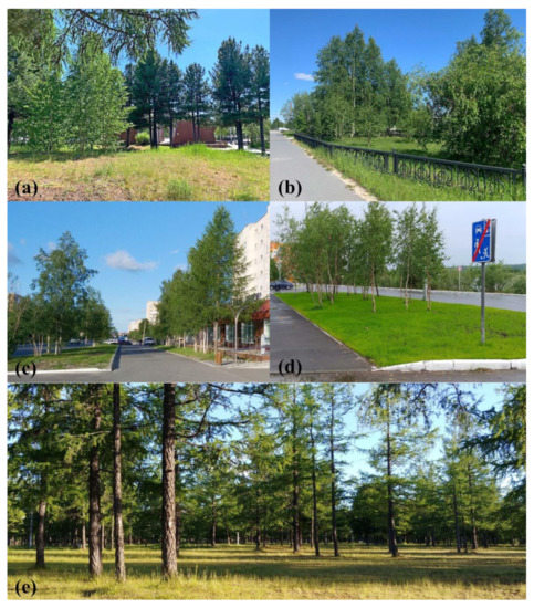
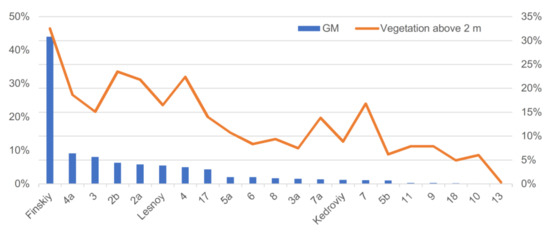
Trees in Arctic cities perform not only important provisional and regulating ecosystem services, but also bring predominantly settler population closer to the visual images and household standards of their home southern regions. However, maintenance of green infrastructure in the Arctic has specific difficulties associated with the harsh climatic and environmental conditions. This paper focuses on state and dynamics of vegetation in the city of Nadym, Russia, with a particular focus on native and introduced trees as the main ecosystem service providers and an articulation of local values towards green spaces. The research is based on interdisciplinary approach which includes interviews with local residents, geobotanical survey and analysis of remote sensing data. The results of the study show that maintaining of natural vegetation requires specific measures due to environmental the critical impact of anthropogenic activity. The active introduction of plants from more southern regions is manifested both in the deliberate practice of landscaping the city’s streets and courtyards, and in spontaneous attempts to introduce plants from more southern (not Subarctic) agricultural regions of Russia, which are privately brought by city residents from other regions.
Full article
(This article belongs to the Special Issue Human-Urban Green Space Interactions and Their Integration into Urban and Green Space Planning and Management)
▼
Show Figures
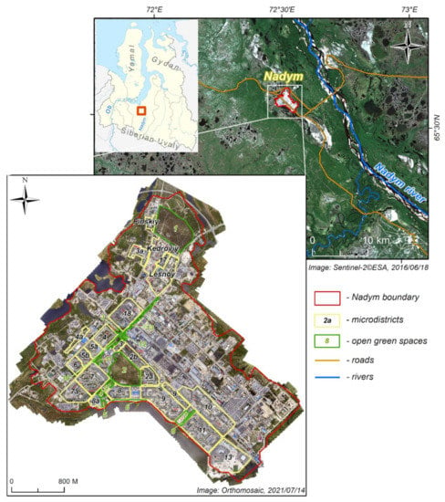
Figure 1


