Article

Effect of Gated Weir Opening on the Topography and Zooplankton Community of Geum River, South Korea

1
National Institute of Ecology, Seo-Cheon Gun 325-813, Korea
2
Department of Biological Sciences, Pusan National University, Geumgeong-gu, Busandaehak-ro 63, Busan 609-735, Korea
*
Author to whom correspondence should be addressed.
Land 2022, 11(4), 529; https://doi.org/10.3390/land11040529
Submission received: 12 February 2022 / Revised: 28 March 2022 / Accepted: 1 April 2022 / Published: 6 April 2022

Abstract

:
Hydrological changes affect not only the physicochemical factors and habitat structure of river ecosystems, but also the structure of biological communities sensitive to environmental changes, such as zooplankton. In this study, we investigate the effects of weir opening on environmental variables and topographic structures at Sejong Weir in South Korea and monitor the resulting changes in the structure and distribution of the zooplankton community. Weir opening led to increased dissolved oxygen and decreased conductivity, turbidity, chlorophyll a, total phosphorus, and total nitrogen and increased the diversity of topographic structures (reduced pool area and increase riffle and grassland/bare land areas) in the section downstream of Sejong Weir. Prior to weir opening (2015–2016), the cladoceran community was dominated by Chydrous spaeericus and Moina microcopa. After opening (2018–2019), the abundance of other cladoceran communities such as Bosmina groups (Bosmina longiseta, Bosmina fatalis, and Bosminopsis deitersi), Ceriodaphnia sp., and Daphnia obtusa increased. In contrast, the copepod species (Cyclops vicinus and Mesocyclops leukarti) were abundant before weir opening. We conclude that artificial weir opening helped maintain the unique environmental characteristics of the river ecosystem in terms of river continuity and led to a different zooplankton community composition in the new river environment.

1. Introduction

Hydrological characteristics are among the main drivers of freshwater ecosystems; they induce dramatic environmental changes by affecting physical and chemical factors in the aquatic environment [1,2]. Hydrological events, such as turbulence and flow fluctuations, lead to physical changes at different depths of the water column as well as changes in sediment conditions [3,4]. These result in temporal and spatial differences in the chemical properties of water, such as dissolved oxygen, pH, and turbidity [5]. In freshwater ecosystems, such hydrological dynamics typically occur in lotic ecosystems such as rivers and streams that involve water flow, which is a major cause of various hydrological changes. In contrast, wetlands and lake ecosystems have relatively stagnant water environments. Artificially constructed dams or weirs cause rapid hydrological changes in river ecosystems [6,7]. Although these lateral structures help secure water resources in countries where rainfall is concentrated during certain seasons, they also affect the physical (velocity, depth, and discharge) and chemical (conductivity and turbidity) factors in the streams where they are located [8]. Thus, hydrological changes in the vicinity of such structures are predominantly artificial rather than natural [9].
Empirical studies have suggested that artificial discharge from dams or weirs induces notable changes in the environmental variables of rivers [10,11]. As dam water is discharged after an increase in the water level of the dam, the water discharged downstream is characterized by high turbidity, conductivity, total phosphorus, and total nitrogen [12]. Moreover, various materials carried from the upstream section of the river accumulate significantly in the downstream section. This can result in increased concentrations of phosphorus or nitrogen during periods of low water flow and low dam discharge, which causes eutrophication [13]. In South Korea, changes in the volume of dam discharge in river ecosystems are largely caused by seasonal effects. That is, dam discharge is frequent in the high-rainfall summer season, but rare in other seasons (i.e., spring, autumn, and winter) in order to maintain water levels in reservoirs. As a result, substantial hydrological changes occur seasonally in the downstream sections of rivers in addition to the natural seasonal variations in environmental variables (e.g., turbidity, conductivity, total phosphorus, and total nitrogen) [14,15].
In addition, the construction of dams or weirs in a river body simplifies the river topographic structure, typically to only one or two topography types [16]. Dams and weirs mainly function to maintain water levels to ensure the continuous availability of water resources, thereby creating a river environment with a higher water level than that prior to the construction of the dam or weir [17]. When the depth of a river or stream is low, the bottom layer is supported by various topographic structures such as sandbars and islands that develop because of the curvature of the riverbed and differences in its longitudinal and horizontal altitude [18]. Conversely, high water levels result in a low topographical diversity. In the absence of artificial structures such as dams in a river ecosystem, water flow is dependent on the location and frequency of riffles and pools created by topographic structures [19,20]. Thus, by reducing the water level, dam discharge can lead to recovery of the topographic structure of the river. However, temporary dam discharge is not conducive to maintaining the characteristics of the downstream river environment as hydropeaking (sudden dam/weir opening, and sudden flood/pulse in the downstream regions) might have a defining influence on the topography and overall discharge profile
Among the various aquatic organisms inhabiting rivers or streams, zooplankton is a biological community that responds sensitively to hydrological factors such as changes in water flow [21,22,23]. As most zooplankton communities exhibit planktonic swimming characteristics, rapid water flow has a negative impact on their distribution [24]. Therefore, these species are predominantly distributed in parts of the river ecosystem where water flow is relatively low [25]. However, eutrophication can occur easily under stagnant or low water flow conditions, making it difficult to maintain stable and diverse zooplankton communities as few zooplankton species become dominant in such environments [24]. Furthermore, eutrophication results in a high water temperature, low dissolved oxygen, and low food diversity, which disturb the distribution and population growth of zooplankton communities in river ecosystems [26]. Empirical studies have suggested that the rotifer community is predominantly influenced by the diversity and abundance of food sources (i.e., phytoplankton and bacteria), which change as a function of environmental changes (bottom-up control; [27,28]); in contrast, cladocerans and copepods experience structural changes caused by predators such as fish and invertebrates [29]. This difference is the result of a combination of various factors, such as body size, swimming pattern, and response (morphological or behavioral) to disturbance. Therefore, the presence and structural characteristics of physical refuges for predator avoidance, such as aquatic macrophytes, are essential for stable growth of the cladoceran community [30]. In order to clearly identify the community composition and spatiotemporal distribution of cladocerans and copepods in a river, it is important to investigate the relationship between these communities and the structure of their microhabitat. As the physical microhabitat structure of freshwater ecosystems mainly depends on aquatic macrophytes [31,32], the abundance of these organisms must also be considered.
In this study, we investigate the effects of hydrological changes caused by the opening of weir floodgates on a selection of environmental variables of a river ecosystem in South Korea and its cladoceran community structure. Specifically, Sejong Weir—the uppermost of the three weirs in Geum River—has continuously influenced hydrological factors in the middle and lower reaches of the river since its construction under the River Refurbishment Project in 2012. Weirs built in other major river basins in South Korea (e.g., Han River, Nakdong River, and Yeongsan River) are expected to show similar effects. Previous studies have described the effects of removal (completely or partly) of weirs or dams and that of weir opening over a specific period of time. The negative impacts of dams and weirs on factors such as water quality and biological distribution have been observed in the river ecosystems of various countries, including South Korea [33,34]. However, few studies have been conducted on the effects of the continuous opening of weirs by reducing the function (e.g., water resource retention) of weir, as in the present study. Therefore, understanding the impact of weir opening on the downstream ecosystem can provide crucial information for establishing management strategies such as dam retention or demolition. The aims of this study are to: (1) identify changes in the cladoceran community structure and abundance in response to the opening of Sejong Weir, and (2) determine the spatial distribution patterns of the cladoceran community in relation to topographical changes in the section downstream of Sejong Weir. We hypothesize that the changes in environmental variables and topographical structures caused by dam discharge influence the composition and abundance of the cladoceran and copepod community. This research enhances our understanding of the ecological relationships between zooplankton distributions and hydrological characteristics.

2. Materials and Methods

2.1. Study Site

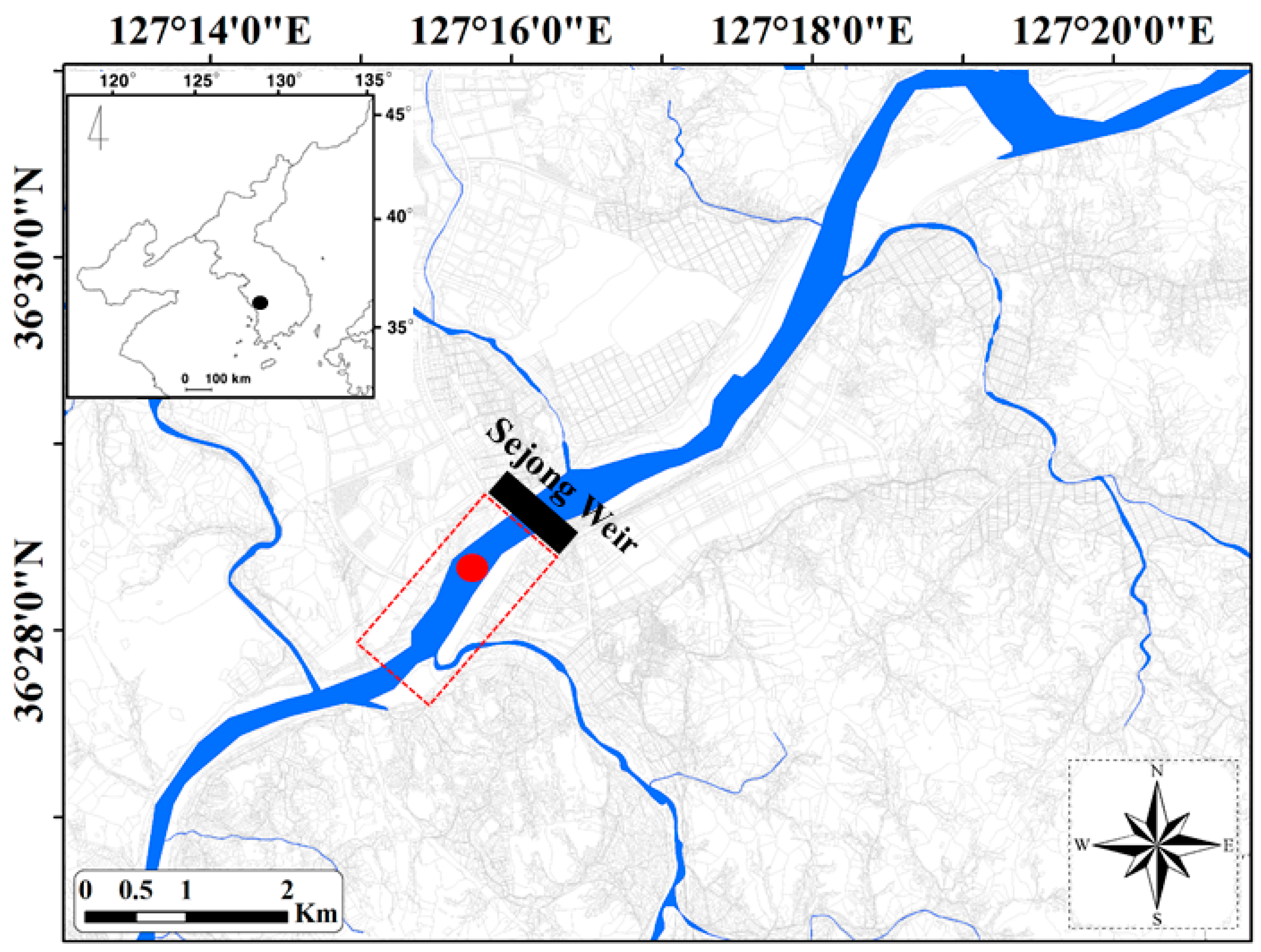
The study site is located in the middle section of Geum River, immediately downstream of Sejon Weir (Figure 1). Geum River is one of five major rivers (Han River, Nakdong River, Geum River, Yeongsan River, and Seomjin River) in South Korea, and is the third largest river (length 394.79 km, basin area 9912.15 km2) after Nakdong and Han Rivers. Geum River is joined by approximately 20 large and small tributaries such as Miho Stream, Cho River, and Gap Stream, and occupies a large basin area in the central part of South Korea. Daecheong Dam and Yongdam Dam, which were completed in 1980 and 2001, respectively, control water flow in the upper reaches of Geum River. However, the upper reaches maintain their unique upstream characteristics of high slopes, abundant water sources, and rapid water flow. Hence, various species of fish and invertebrates are distributed in the upper reaches of Geum River, which form an important habitat for some endangered species (Pseudopungtungia nigra, Coreoperca kawamebari, and Lamprotula coreana [35]). The middle and lower reaches of Geum River, from downstream of Daecheong Dam to the Geum River estuary, are wide and deep, and characterized by substantial artificial interference because of the proximity of urban areas including Daejeon, Sejong, Buyeo, and Gunsan. Construction of the Geum River estuary in 1990 completely blocked the inflow of seawater, which resulted in relatively stagnant conditions in the 30–50 km section upstream of the estuary bank.
From 2009 to 2012, three large weirs (Sejong, Baekje, and Gongju) were constructed in the middle and lower sections of Geum River as part of the River Refurbishment Project. Weir construction caused the middle and lower reaches of Geum River to become more stagnant and deeper. These weirs maintain the water level at approximately 10–15 m, and are rarely discharged during the year, except in the rainy season (summer to autumn). Because of these lake-like environmental conditions, the inherent characteristics of the original river ecosystem have been lost, with eutrophication events and algae blooms occurring frequently. Through the efforts of local governments and civic groups to preserve the unique characteristics of the river, the floodgates of each weir have been completely opened since 2017, resulting in low water levels and the development of various topographic structures, such as sandbars and islands. Among the three weirs built on Geum River, Sejong Weir is the smallest (348 m wide). As there is little difference in altitude between the upper and lower parts of Sejong Weir, it is highly likely that the unique characteristics of the river will eventually be restored by opening the floodgate. The survey area selected in this study is located approximately 7 km downstream of Sejong Weir, so is directly affected by the opening of the Sejong Weir floodgate.

2.2. Topographic Structure Analysis

The topographic structure in the 7 km section downstream of Sejong Weir was evaluated to identify the topographic changes that occurred before, during, and after the opening of Sejong Weir. The year 2015 reflected the period before weir opening, the year 2017 reflected the period when the management level was maintained, immediately after weir opening, and the year 2020 represented the period two years after weir opening. These changes were identified in spring (from March to May) in consideration of the climate pattern in South Korea (thereby avoiding concentrated summer rainfall and its effects in autumn). Each topography type was delineated using a combination of remotely sensed and field-collected data (see Kobayashi et al. [36]). Specifically, the area of each topography type was measured using a geographic information system program (ArcGIS 10.5.1) and a digital map (National Geographic Information Institute, 2016; 1:25,000). Characterized structures in the study area were obtained from satellite images (Daum Kakao Map) with a 50 cm resolution. Using this approach and guidelines adapted from Johansen et al. [37] and Holmes and Goebel [38], the three following topographic structure types were identified in the study area: pools, riffles, and grassland/bare land.
We also measured the coverage area and relative ratio of aquatic macrophyte species in pools. Six species (i.e., Paspalum distichum, Phragmites communis, Hydrocharis dubia, Trapa japonica, Typha orientalis, and Zizania latifolia) of aquatic macrophytes were dominant in this topographic structure, whereas the other spaces were open areas unoccupied by aquatic macrophytes (i.e., no plants were present). Although other plant species (in addition to the six dominant plant species) were also distributed in the study area, they occupied a very small area of less than 1000 m2, so were excluded from the analysis.

2.3. Monitoring Strategy

Monthly monitoring was conducted in the study area over a five-year period from 2015 to 2019. Prior to monitoring, the sections of Geum River affected by Sejong Weir were investigated to identify suitable locations for this study. Consequently, we selected a section located 7 km downstream from Sejong Weir. The following eight environmental variables were measured at all study sites: water temperature, dissolved oxygen (DO), pH, conductivity, turbidity, chlorophyll a (Chl a), total nitrogen (TN), and total phosphorus (TP). A DO meter (YSI Model 58; Yellow Springs, OH, USA) was used to measure water temperature and DO. Conductivity and pH were measured using a conductivity meter (YSI model 152; Yellow Springs, OH, USA) and a pH meter (Orion Model 250 A; Orion Research, Beverly, MA, USA), respectively. To measure the remaining environmental variables, 10 L water samples were transported to the laboratory. Turbidity was measured using a turbidimeter (Model 100 B; HF Scientific Inc., Ft. Myers, FL, USA). To determine Chl a concentration, water samples were filtered through 0.45-µm mixed cellulose ester membrane filters (A045A047A; Advantech Co. Ltd., Taipei, Taiwan). The filtrates for Chl a and the remaining water samples were used to determine the concentration of Chl a, TN, and TP according to the method of Wetzel and Likens [39].
In addition, the hydrological data of Sejong Weir (upstream level, downstream level, dam discharge, and dam storage) were obtained from the Water Resources Management Information System (WAMIS, http://www.wamis.go.kr, accessed on 16 January 2022). From these data, the hydrological differences before (2015–2016) and after (2018–2019) the opening of Sejong Weir were identified and compared with the annual or seasonal distribution of environmental variables and zooplankton community composition.
To determine the abundance of zooplankton (i.e., cladocerans and copepods), 5 L water samples were collected using a water sampler (10 L column; length 20 cm; width 30 cm; height 70 cm). The sampler was placed vertically into the water to collect the zooplankton. The sampled water was then filtered through a plankton net (70-µm mesh), and the filtrate was preserved in sugar formalin (final concentration: 4% for formaldehyde) [40]. Cladoceran and copepod quantification and identification at the species or genus level were performed using a microscope (ZEISS, Model Axioskop 40; ×200 magnification), with identification based on the classification key published by Mizuno and Takahachi [41] and Thorp and Covich [42].
To better understand the annual distribution of zooplankton clusters, the zooplankton community was investigated in three types of topographic structure (pools, riffles, and grassland/bare land) observed after weir opening. This investigation was conducted before the summer monsoon, from late May to early Jun (in 2018 and 2019), to avoid any physical disturbance to the zooplankton community from heavy rainfall [7,43]. As grassland/bare land is a terrestrial area, zooplankton collection was conducted in the littoral part of this topographic structure. We selected three sampling points for each topography type (pools, riffles, and littoral areas); thus, zooplankton communities were collected from a total of nine sampling points. The sample processing procedure was similar to that for the monthly samples. After monthly monitoring over five years, we obtained 60 data points for chemical factors and zooplankton communities (one site), and nine data points for habitat-based assessment (zooplankton communities in the three topography types).

2.4. Data Analysis

Paired t-tests were used to examine the differences in hydrological factors, environmental variables, and zooplankton density before (2015–2016) and after (2018–2019) the opening of Sejong Weir. We excluded 2017 from the analysis as this was the year the floodgate began opening at Sejong Weir. One-way ANOVA was used to examine the effects of topographic changes on the zooplankton community and the differences in mean values among the three topographic types (pools, riffles, and grassland/bare land). Statistical analyses were performed using SPSS for Windows (IBM Corp. V. 20.0. Armonk, NY, USA). Tukey’s test was used for additional post hoc comparison analysis to identify the differences that were statistically significant. Differences and relationships were considered statistically significant at p < 0.05. Before being included in the tests, all data were tested for normality (Shapiro–Wilk test) after log-transformation.

3. Results

3.1. Hydrological Factors and Environmental Variables

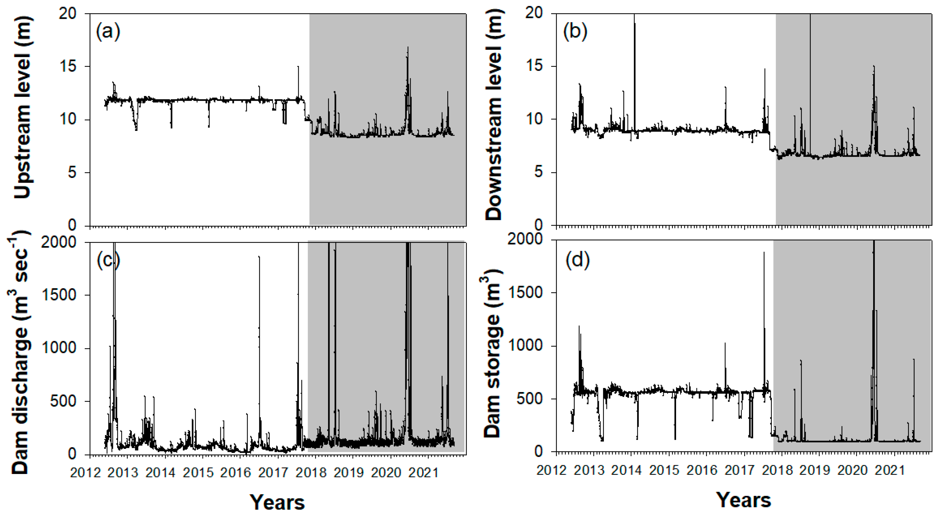
The hydrological factors of Sejong Weir led to predictable environmental changes in accordance with floodgate operation (Figure 2). Although these factors exhibited some seasonal variations, the differences before (2015–2016) and after (2018–2019) weir opening were identified through a comparison of average values. The water level (i.e., upper and lower level) and dam storage of Sejong Weir were lower after (2018–2021) than those before (2012–2017) weir opening, whereas dam discharge increased. The average dam storage was 573 m3 before opening but 86 m3 after opening, with Sejong Weir performing minimal weir functions after opening. Conversely, the dam discharge amount increased slightly from 116 m3 s−1 before opening to 274 m3 s−1 after opening, but seasonal variation was lower before dam opening than after dam opening. Both before and after weir opening, dam discharge was high in the summer and autumn (345 m3 s−1) and low in winter and spring; however, the difference between the two seasons decreased significantly after weir opening. The differences between these four hydrological factors before and after weir opening were statistically significant (t-test, p < 0.05).
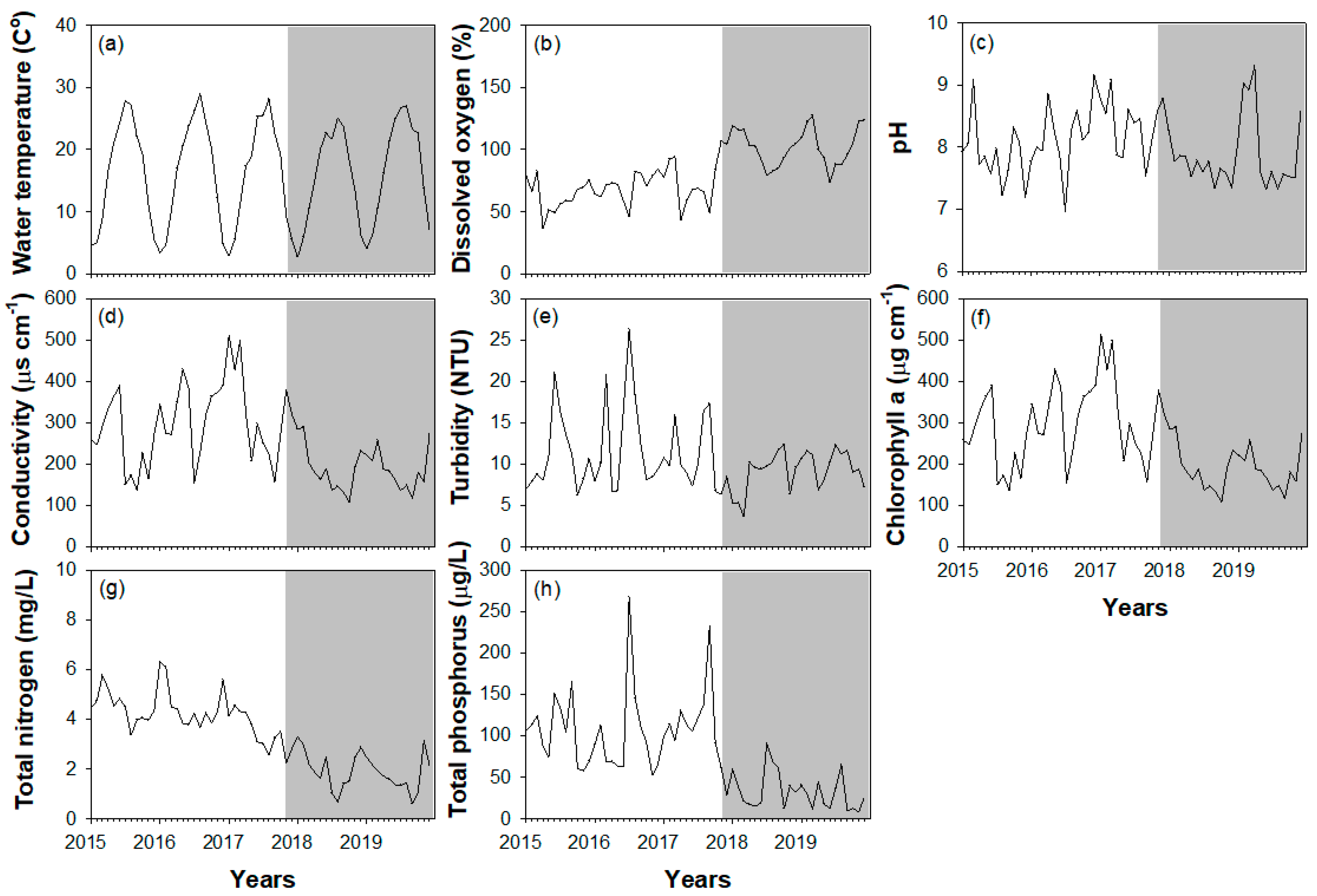
Fluctuations in environmental variables were clearly observed (Figure 3) with high water temperatures in summer (June to August) and low water temperatures in winter (November to February), whereas DO, conductivity, Chl a, and TN showed the opposite pattern (low in summer and high in winter). Interannual and seasonal patterns of the remaining variables (pH, turbidity, and TP) were relatively irregular. Environmental variables differed dramatically before and after the opening of Sejong Weir (Figure 3 and Table 1). Conductivity, turbidity, Chl a, and TP decreased significantly after weir opening. These differences were statistically significant, with values decreasing by two to three times after opening.

3.2. Topographic Structure

The topographic structure of the section (7 km) downstream of Sejong Weir was clearly different before and after weir opening (Figure 4 and Table 2). Before weir opening (2015), most of the section downstream of Sejong Weir was occupied by pools, except for some areas covered by grassland/bare land. After opening the weir, the area occupied by pools gradually and significantly decreased, from 92.7% of the total downstream area before weir opening to 54.8% and 45.9% immediately after weir opening (2018) and two years after weir opening (2020), respectively. In contrast, riffles were absent before weir opening, but increased gradually to 20.2% of the total area after opening and to 23.6% two years after opening. The area of grassland/bare land accounted for only 7.3% of the total downstream sections before opening, but it increased to 25% and 30.4% after opening and two years after opening, respectively.
The area and relative ratio of aquatic macrophytes in the pools were also clearly affected by weir opening (Table 3). Before weir opening (2015), the relative ratio of aquatic macrophytes in pools was 49% (area 283,411 m2); this decreased to 10.5% (area 35,969 m2) and 18.1% (area 51,839 m2) after weir opening (2018) and two years after weir opening (2020), respectively. Among the aquatic macrophyte communities occupying the pool area, Phragmites communis covered the largest area, followed by Typha orientalis and Zizania latifolia. The proportion of Phragmites communis was 19.8% (area 114,506 m2) before weir opening (2015) but only 6.8% (23,421 m2) and 11.3% (32,415 m2) after weir opening (2018) and two years after weir opening (2020), respectively. This coverage pattern was also observed for Typha orientalis and Zizania latifolia. The remaining aquatic macrophyte species (Paspalum distichum, Hydrocharis dubia, and Trapa japonica) cumulatively had a coverage rate of less than 5% during the study period.

3.3. Zooplankton Community Composition

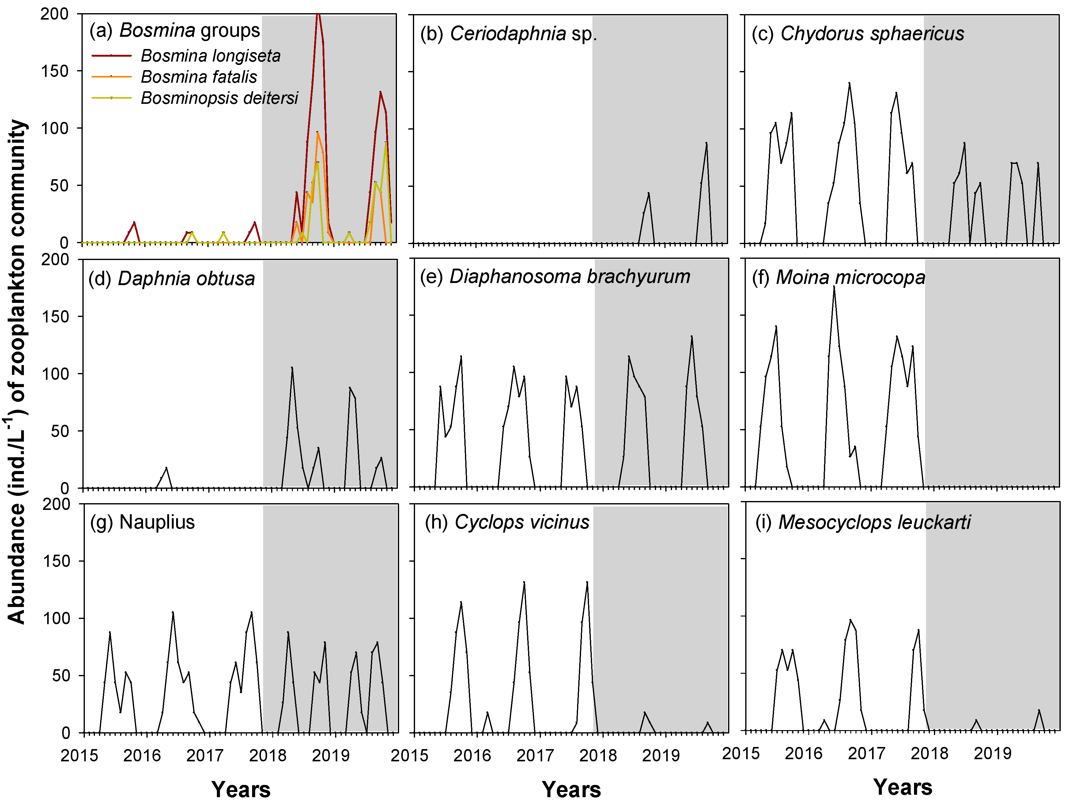
Seasonality in most zooplankton species showed a similar pattern (Figure 5). The zooplankton community was abundant from spring (March to May) to autumn (September to November), whereas low abundance was observed from November (start of winter) to March of the following year. The zooplankton community was supported by the high abundance of spring- or autumn-dependent species but showed a similar pattern of decreasing abundance in summer. Zooplankton community abundances showed a clear difference before and after weir opening (Figure 5 and Table 4). Within the cladoceran community, Bosmina groups (Bosmina longiseta, Bosmina fatalis, and Bosminopsis deitersi), Ceriodaphnia sp., and Daphnia obtusa were more abundant after weir opening, whereas the abundance of Chydrous sphaericus and Moina microcopa decreased after the opening of the weir. In particular, Ceriodaphnia sp. and D. obtusa were either very rare or not observed before opening but highly abundant after weir opening; in contrast, M. microcopa was very abundant before opening but absent from the study area after weir opening. In the copepod community, the abundance of Cyclops vicinus and Mesocyclops leuckarti was also reduced after weir opening. Compared to before weir opening, their abundance decreased by approximately four to five times after weir opening. In contrast to the aforementioned zooplankton species, Diaphanosoma brachyurum and Nauplius showed no change in abundance after weir opening. According to NMDS analysis, each zooplankton species had a minimal influence on environmental variables.
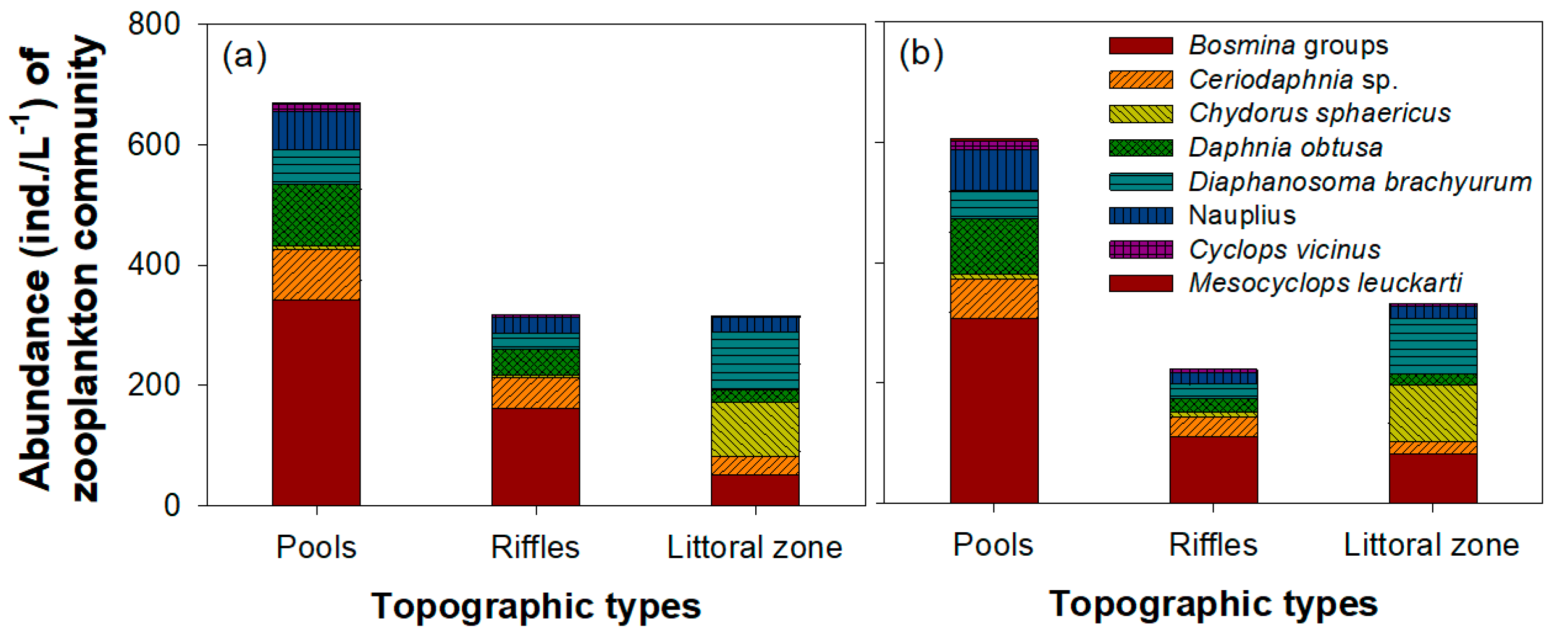
The abundance of zooplankton communities differed according to the three topographic structures that developed in the study area (pools, riffles, and grassland/bare land; one-way ANOVA, p < 0.05) after weir opening (Figure 6). Pools supported the highest abundance of zooplankton communities among the three topographic types, followed by riffles and littoral zones. However, the difference in zooplankton abundance between riffles and littoral zones was minimal. This difference was attributed to zooplankton species (Bosmina groups, D. obtusa, and Nauplius) whose density increased after weir opening. In contrast, a high density of D. brachyurum and C. sphaericus was observed in littoral zones, and Ceriodaphnia sp. was abundant in both pools and riffles. Cyclops vicinus and M. leukarti exhibited no difference in abundance between topographic structure types because of their low density after weir opening.

4. Discussion

4.1. Environmental Variables and Topographic Changes after Weir Opening

The results of this study show that weir opening led to changes in environmental variables and topographic structures in the downstream section of Sejong Weir. After weir opening, Sejong Weir performed minimal dam functions, such as securing water storage or controlling the water flow, because both the upstream and downstream water levels of the dam decreased. The renewal of water flow and reduction in water level caused by weir opening led to dramatic changes in various environmental variables and induced recovery of the unique river ecosystem characteristics. The most noticeable changes in environmental variables after weir opening were increased DO and decreased nutrient concentrations (TN and TP). In general, considering that DO is higher in rivers and streams where water velocity is rapid, [44] the high DO (>80%) after weir opening implies that water flow downstream of Sejong Weir increased compared to that prior to weir opening. In general, maintaining adequate water flow induces oxygen inflow from the atmosphere into the water, whereas an environment with little or no water flow exhibits a very low DO value [45,46].
The occurrence of higher discharge after weir opening also induced changes in nutrient concentrations. Empirical studies have suggested that the absence of water flow can cause an increase in the residence and accumulation of nutrients such as TP and TN, further leading to eutrophic conditions and algal blooms [47,48]. Before weir opening, the section downstream of Sejong Weir was supported by mesotrophic or eutrophic conditions; however, this trophic state improved substantially after weir opening. The decreased Chl a concentrations after weir opening may be the result of the lower nutrient concentrations [49] or the renewed water flow [50].
The water flow renewal and water level reduction caused by weir opening also affected the topographic structures in the section downstream of Sejong Weir. Before weir opening, this section mostly consisted of pools; however, after weir opening, the area of pools gradually decreased, to be gradually replaced by riffles and grassland/bare land. This increase in the area of grassland/bare land induced diversity in the water flow. Empirical studies have found that the length or edge shape of islands not only increases the frequency of erosion and deposition by affecting the occurrence and size of pools and rivers, but also contributes to an increase in water flow diversity [51,52]. Moreover, the long or short length of the island and whether the shape of the island is close to a circle or straight line determine the meanders of water flow. After weir opening, the coexistence of riffles and pools in the section downstream of Sejong Weir increased the diversity of microhabitats compared to those in the environment before weir opening, which was dominated by only pools; therefore, weir opening likely also increased the distribution of various biological communities.
However, it is estimated that these changes caused by the regular opening of Sejong Weir were also affected by the unique weather as well as climate change. Although the effects of climate or weather were not addressed in detail in the present study, several previous studies have already suggested that summer rainfall has a significant impact on river ecosystems in South Korea [24,53]. Water flow of most Korean rivers, including the Geum River, is regulated via weir or dams, and rainfall is concentrated in summer in the study area, which leads to an increase in dam discharge and water velocity [54]. Such physical disturbances negatively affect the distribution or population growth of various aquatic organisms, including zooplankton. Previous studies have suggested that summer rainfall in East Asia has a “resetting” effect and sharply reduces the density of plankton community that began to increase in spring, thereby reducing the abundance of certain plankton species. [20,24,55]. Hence, it is estimated that climate change can affected the carious environmental variables in a river ecosystem in the study area. However, environmental variables (i.e., conductivity, turbidity, chl. a, and TP) exhibited clear differences even in spring and autumn, when the impact on summer rainfall is somewhat low, implying that weir opening affected these variables. If climate data such as rainfall are secured in the region in the future, questions about these estimates are expected to be resolved.

4.2. Change of Zooplankton Community Composition after Weir Opening

Hydrological changes caused by the opening of Sejong Weir had a strong influence on the zooplankton community composition and environmental variables. Dramatic changes in the physical (water depth, flow rate) and chemical (DO, TP, TN) factors after weir opening may have affected the zooplankton community. Previous studies have also suggested that zooplankton communities are sensitive to environmental changes, such as physicochemical factors, which result in changes in species composition and abundance [56,57]. Low water temperature and Chl. a and high turbidity and nutrient concentrations are major factors promoting low species diversity and abundance in zooplankton communities [58]. Zooplankton species have specific habitat preferences and can react sensitively to changes in their habitat environment. Prior to weir opening, the section downstream of Sejong Weir was dominated by zooplankton species such as C. sphaericus, M. microcopa, C. vicinus, and M. leuckarti, and considered stagnant, with a high water depth and nutrient concentration, which provided suitable habitat conditions for these zooplankton species. Empirical studies have also suggested that these zooplankton species are mainly observed in ecosystems with a similar habitat environment to that in the study site prior to the opening of Sejong Weir [59,60].
Prior to weir opening, the section downstream of Sejong Weir was maintained at a fixed depth and area, which led to a stable distribution of macrophyte species such as P. communis and T. orientalis in the littoral region. We speculate that the development of littoral vegetation contributed to an increased density of zooplankton species (C. sphaericus, M. microcopa, C. vicinus, and M. leuckarti) prior to the opening of the weir. Previous studies also observed cladoceran species such as C. sphaericus and M. microcopa in wetlands and shallow reservoirs where aquatic macrophytes were abundant [36,61]. These cladoceran species are more epiphytic than pelagic swimmers such as Daphnia or Bosmina; thus, substrate surfaces, such as the leaves and stems of macrophytes, are important for their distribution [62]. Choi et al. [63] suggested that the different leaf and stem structures of aquatic macrophytes (e.g., emergent, floating, and submerged macrophytes) could affect the temporal and spatial distribution of epiphytic zooplankton species. Furthermore, a complex space caused by the leaves and stems of macrophytes can disturb predators such as fish from searching for food items, thereby promoting the survival and continuous population growth of their zooplankton prey [64]. Therefore, before weir opening, the presence of an area covered by aquatic macrophytes was important for the stable population growth of zooplankton communities as it provided a stable habitat for attachment as well as efficient avoidance of predators.
However, the range of water level fluctuations increased after weir opening, the frequency of flooding in the waterside area became low or intermittent, and the abundance of aquatic macrophytes decreased under this unstable environment. Moreover, the coverage rate of aquatic macrophytes in pools decreased from 49% to 10.5%. This rate showed relatively low recovery, with macrophyte coverage only 18% two years after weir opening. These environmental changes were sufficient to cause a decrease the abundance of zooplankton species such as C. sphaericus, M. microcopa, C. vicinus, and M. leuckarti, which dominated the site prior to weir opening [65]. This rapid decline in the density of epiphytic species such as C. sphaericus and M. microcopa was caused by rapid water flow, flooding, and high water levels during the summer when rainfall is concentrated, and it is closely related to the swimming patterns of these species [66]. Epiphytic species that live away from substrate surfaces, such as the leaves and stems of aquatic macrophytes, have difficulty achieving stable distribution and population growth [62]. However, some rotifer species avoid the physical disturbance caused by concentrated summer rainfall by increasing their frequency of attachment to the leaves and stem surfaces of aquatic macrophytes [24], whereas relatively large cladocerans cannot stably attach to aquatic macrophytes. The exceptions to this behavior are cladoceran species such as Sida crystallina, which can firmly attach to the leaves and stems of macrophytes through adhesive anchors located in their head [67].
Zooplankton species such as Bosmina groups (B. longiseta, B. fatalis, and B. deitersi), Ceriodaphnia sp., and D. obtusa, which exhibited increased density after weir opening, are typical pelagic species that can be stably distributed in some degree of flow. Providing refuge to avoid predators, which is one of the main functions of aquatic macrophytes, is also of great benefit to these zooplankton species; however, given that they are filter-feeding consumers, open areas (i.e., no plants) are more advantageous for their distribution than areas covered by aquatic macrophytes (i.e., the complex and narrow environment caused by the leaves and stems of aquatic macrophytes disturbs the food activities of filter-feeding cladoceran species) [68]. In addition, in areas where aquatic macrophytes are abundant (i.e., because of low phytoplankton species diversity and density caused by nutrient competition), zooplankton can find it difficult to acquire a stable food supply [69]. Thus, typical filter feeders such as Bosmina, Ceriodaphnia, and Daphnia are mainly found in the middle or downstream of rivers rather than in wetlands or shallow reservoirs covered with aquatic macrophytes [70,71]. Because of these habitat characteristics, we assumed that recovery of the unique river ecosystem characteristics, including rapid water flow and low water depth after the opening of Sejong Weir, were sufficient to increase the abundance of these zooplankton species.
The effect of functional degradation and removal of dams on downstream biota has been described in several previous studies. For example, an increase in dam discharge due to dam functional degradation and removal leads to high discharge and rapid water flow, thereby removing and transporting the sediment accumulated after dam construction. These physical environmental changes affect not only zooplankton groups but also invertebrates and fish communities. Chiu et al. [72] suggested that large amounts of sediment transport after dam removal lead to a sharp decline in benthic populations, including algae and invertebrates. Thereafter, changes in the invertebrate community differ for each classification group. Orr et al. [73] suggested that trichopterans and ephemeropterans, which are relatively long-lived, are severely affected by dam removal, whereas short-lived dipterans recover relatively quickly. Similarly, rotifers with shorter life cycles react before cladocerans and copepods to changes in dam discharge [74]. In the present study, it is highly likely that gradual changes in the downstream environment after weir opening led to the decrease in the density of zooplankton species that were initially dominant. However, physical factors such as water flow and water level change seasonally and have large dynamic range; therefore, it is difficult to continuously affect zooplankton community throughout the year. Furthermore, changes in food sources and predators by downstream environments created after weir opening may influence the community structure of cladocerans and copepods. Phytoplankton, the main food source for zooplankton, is sensitive to physical factors such as water flow rate and water depth as well as chemical factors such as dissolved oxygen and trophic status, which may have led to a clear difference between before and after weir opening. [75,76]. Similarly, these hydrological changes can affect not only the type of predator but also changes in food activity [77]. The distribution and foraging activities of bluegill (Lepomis macrochirus) and largemouth bass (Micropterus salmoides), the dominant fish in South Korea, depend not only on hydrological factors but also on environmental changes [78,79,80]. Hence, the environment created after weir opening is judged to be suitable for a few cladoceran species (such as Bosmina groups, Ceriodaphnia sp., and D. obtusa) and an increase in their density was observed after weir opening. In contrast, this environment was not preferable for certain zooplankton species (such as C. sphaericus, M. microcopa, C. vicinus, and M. leuckarti) that were dominant before weir opening. Therefore, a combination of several factors can influence changes in zooplankton community composition after weir opening. These factors include direct effects on hydrological factors as well as indirect effects such as cascade interactions between compositional factors in the food web.
Furthermore, the abundance of zooplankton communities differed among the three types of topographic structure (pools, riffles, and littoral zones) created after weir opening. Pools were characterized by the highest zooplankton abundance, whereas riffles and littoral zones showed similar abundance levels. Although pools occupied a large area even before weir opening, we estimate that the environmental variables in pools differed before and after weir opening. Before weir opening, pools occupied large areas and other topographic types (riffles and grassland/bare land) were small. However, after weir opening, pools were located adjacent to riffles or grassland/bare land; thus, they were likely affected by these topographic structures after the opening of the weir. After weir opening, high DO and low turbidity and nutrient values were caused by newly created riffles or grassland/bare land areas, which were attributed to better flow conditions and connectivity between different habitats. Although pools exhibit minimal water flow, this can change with environmental changes in adjacent areas. Nevertheless, the stable distribution of pelagic zooplankton species such as Bosmina species (B. longiseta, B. fatalis, and B. deitersi), Ceriodaphnia sp., and D. obtusa is difficult in areas of rapid water flow, such as area under riffles. After weir opening, environmental changes in pool areas seem to have greatly influenced the zooplankton community composition.

4.3. Weir Management for River Ecosystem Conservation

Current research is increasingly focusing on the effectiveness of opening weirs constructed in large river ecosystems in South Korea. In 2012, 16 weirs were newly constructed in four major rivers (Han River, Nakdong River, Geum River, and Yeongsan River) in South Korea to secure sustainable water resources. However, these weirs became increasingly negatively perceived as water flows decreased and eutrophication and algal blooms became more frequent. In this study, we observed that the middle parts of Geum River exhibited similar environmental characteristics to those of the downstream regions (e.g., high water depth, low flow, low DO) in response to weir construction; thus, the unique habitat characteristics of this region were greatly damaged. This led to a decrease in biological communities that preferred or had adapted to the upstream or midstream environments of the river. Although only changes in the composition of zooplankton communities (i.e., cladocerans and copepods) were monitored in this study, it is assumed that changes in zooplankton community composition will have a significant impact on other aquatic organisms, including fish and invertebrates. This assumption is based on the fact that zooplankton species are major food sources for predators, including fish and invertebrates. Therefore, weir opening may be the best way to rapidly restore the unique characteristics of the river ecosystem in the middle areas of the river, where the weir has already been constructed.
However, although the unique environmental characteristics of the river ecosystem are being restored in various ways through the opening of Sejong Weir, it is difficult to determine whether the environmental conditions are similar to those prior to weir construction. There are a total of three sluice gates in Sejong Weir, through which the water inflow from upstream passes; even when the gates are completely open, there is a decrease of 2–3 m between the upper and lower parts of the weir. Based on these observations, it is unlikely that the environmental changes caused by the continuous opening of the weir reflect a full recovery of the pre-weir river environment. Of course, removal of the weir may be the most efficient way to return to the unique environmental characteristics of the middle parts of the river; however, this would involve enormous economic and manpower costs. In addition, the water that is secured in the upper part of the weir is often supplied as agricultural water to nearby agricultural lands or orchards, which is another reason for not demolishing the weir. Consequently, weir management should attempt to simultaneously maintain the function of the weir while restoring the river ecosystem in the middle sections of Geum River. Although not comparable to the pre-construction environment of the weir, weir opening induces clear environmental and topographic structure changes. Therefore, the continuous opening of the weir is recommended to mitigate abovementioned potential negative impacts on the river ecosystem while retaining the various benefits of weir construction.

5. Conclusions

Hydrological changes caused by the continuous opening of the Sejong Weir in the midstream area of Geum River led to clear changes in environmental factors and topographic structures downstream of the weir. Low turbidity, chlorophyll a, and nutrient concentrations (i.e., TP) are major environmental changes observed after weir opening, which occurred in response to a reduction in water depth and a change from abundant pools to large areas of riffles and grassland/bare land. These changes influenced the composition of zooplankton communities before and after weir opening. Before weir opening, the zooplankton community was dominated by C. sphaericus, M. microcopa, C. vicinus, and M. leuckarti, whereas after weir opening, Bosmina groups (B. longiseta, B. fatalis, and B. deitersi), Ceriodaphnia sp., and D. obtuse became dominant. Although it is difficult to determine whether the environmental characteristics caused by weir opening represents a full return to the pre-weir environment, we suggest that continuous weir opening is suitable for moderate maintenance of the unique environmental characteristics of the middle reaches of this river. As weirs provide water provisioning for agriculture, weir opening can be considered as an alternative to weir removal. In other words, it can be a trade-off between natural systems/functionality and human activities. Because weir construction has negative impacts such as water quality deterioration and eutrophication, weir opening is required to optimize the balanced trade-off between environmental requirements and human needs.

Author Contributions

Conceptualization, J.-Y.C.; methodology, S.-K.K.; validation, J.-Y.C. and S.-K.K.; formal analysis, J.-Y.C.; investigation, J.-Y.C. and S.-K.K.; resources, J.-Y.C.; data curation, J.-Y.C.; writing—original draft preparation, J.-Y.C. and S.-K.K.; writing—review and editing, J.-Y.C. and G.-J.J.; visualization, J.-Y.C.; supervision, J.-Y.C.; project administration, J.-Y.C.; funding acquisition, S.-K.K. All authors have read and agreed to the published version of the manuscript.

Funding

This research was supported by a grant from the National Institute of Ecology (NIE), funded by the Ministry of Environment (MOE) of South Korea (NIE-C-2021-71).

Institutional Review Board Statement

Not applicable.

Informed Consent Statement

Not applicable.

Data Availability Statement

The data presented in this study are available upon request from the corresponding author. The data are not publicly available because of restrictions on the right to privacy.

Conflicts of Interest

The authors declare no conflict of interest.

References

  1. Wu, N.; Qu, Y.; Guse, B.; Makarevičiūtė, K.; To, S.; Riis, T.; Fohrer, N. Hydrological and environmental variables outperform spatial factors in structuring species, trait composition, and beta diversity of pelagic algae. Ecol. Evol. 2018, 8, 2947–2961. [Google Scholar] [CrossRef] [PubMed]
  2. Zhang, Q.; Dong, X.; Chen, Y.; Yang, X.; Xu, M.; Davidson, T.A.; Jeppesen, E. Hydrological alterations as the major driver on environmental change in a floodplain Lake Poyang (China): Evidence from monitoring and sediment records. J. Great Lakes Res. 2018, 44, 377–387. [Google Scholar] [CrossRef]
  3. Harvey, J.; Gomez-Velez, J.; Schmadel, N.; Scott, D.; Boyer, E.; Alexander, R.; Eng, K.; Golden, H.; Kettner, A.; Konrad, C.; et al. How hydrologic connectivity regulates water quality in river corridors. J. Am. Water Res. Assoc. 2019, 55, 369–381. [Google Scholar] [CrossRef] [PubMed]
  4. Knösche, R. Organic sediment nutrient concentrations and their relationship with the hydrological connectivity of floodplain waters (River Havel, NE Germany). Hydrobiologia 2006, 560, 63–76. [Google Scholar] [CrossRef]
  5. Bowling, L.C.; Merrick, C.; Swann, J.; Green, D.; Smith, G.; Neilan, B.A. Effects of hydrology and river management on the distribution, abundance and persistence of cyanobacterial blooms in the Murray River, Australia. Harmful Algae 2013, 30, 27–36. [Google Scholar] [CrossRef]
  6. Wang, H.; Yang, Z.; Saito, Y.; Liu, J.P.; Sun, X. Interannual and seasonal variation of the Huanghe (Yellow River) water discharge over the past 50 years: Connections to impacts from ENSO events and dams. Glob. Planet. Chang 2006, 50, 212–225. [Google Scholar] [CrossRef]
  7. Jeong, K.S.; Kim, D.K.; Joo, G.J. Delayed influence of dam storage and discharge on the determination of seasonal proliferations of Microcystis aeruginosa and Stephanodiscus hantzschii in a regulated river system of the lower Nakdong River (South Korea). Water Res. 2007, 41, 1269–1279. [Google Scholar] [CrossRef] [PubMed]
  8. Ahn, J.M.; Lee, S.; Kang, T. Evaluation of dams and weirs opening for water resource management of the Geum River. Sci. Total Environ. 2014, 478, 103–115. [Google Scholar] [CrossRef]
  9. Woo, H. Trends in ecological river engineering in Korea. J. Hydro-Environ. Res. 2010, 4, 269–278. [Google Scholar] [CrossRef]
  10. Gubiani, E.A.; Gomes, L.C.; Agostinho, A.A.; Okada, E.K. Persistence of fish populations in the upper Paraná River: Effects of water regulation by dams. Ecol. Freshw. Fish 2007, 16, 191–197. [Google Scholar] [CrossRef]
  11. Kim, J.; Kim, J.S.; Kim, G. Nutrient input from submarine groundwater discharge versus intermittent river-water discharge through an artificial dam in the Yeongsan River estuary, Korea. Ocean Sci. J. 2010, 45, 179–186. [Google Scholar] [CrossRef]
  12. Agarwal, A.K.; Rajwar, G.S. Physico-chemical and microbiological study of Tehri dam reservoir, Garhwal Himalaya, India. J. Am. Sci. 2010, 6, 65–71. [Google Scholar]
  13. Grabowska, M. The role of a eutrophic lowland reservoir in shaping the composition of river phytoplankton. Ecohydrol. Hydrobiol. 2012, 12, 231–242. [Google Scholar] [CrossRef]
  14. Shamloo, H.; Rajaratnam, N.; Katopodis, C. Hydraulics of simple habitat structures. J. Hydraul. Res. 2001, 39, 351–366. [Google Scholar] [CrossRef]
  15. Yang, Y.; Zhang, M.; Zhu, L.; Liu, W.; Han, J.; Yang, Y. Influence of large reservoir operation on water-levels and flows in reaches below dam: Case study of the Three Gorges Reservoir. Sci. Rep. 2017, 7, 1–14. [Google Scholar] [CrossRef] [Green Version]
  16. Feurer, D.; Bailly, J.S.; Puech, C.; Le Coarer, Y.; Viau, A.A. Very-high-resolution mapping of river-immersed topography by remote sensing. Prog. Phys. Geogr. 2008, 32, 403–419. [Google Scholar] [CrossRef]
  17. Mermillod-Blondin, F.; Creuzé des Châtelliers, M.; Marmonier, P.; Dole-Olivier, M.J. Distribution of solutes, microbes and invertebrates in river sediments along a riffle-pool-riffle sequence. Freshw. Biol. 2000, 44, 255–269. [Google Scholar] [CrossRef]
  18. Walker, K.F. A review of the ecological effects of river regulation in Australia. In Perspectives in Southern Hemisphere Limnology; Davies, B.R., Walmsley, R.D., Eds.; Springer Science & Business Media: Berlin/Heidelberg, Germany, 1985; pp. 111–129. [Google Scholar]
  19. Mulani, S.K.; Mule, M.B.; Patil, S.U. Studies on water quality and zooplankton community of the Panchganga river in Kolhapur city. J. Environ. Biol. 2009, 30, 455–459. [Google Scholar]
  20. Choi, J.Y.; Jeong, K.S.; Kim, H.W.; Chang, K.H.; Joo, G.J. Inter-annual variability of a zooplankton community: The importance of summer concentrated rainfall in a regulated river ecosystem. J. Ecol. Environ. 2011, 34, 49–58. [Google Scholar] [CrossRef] [Green Version]
  21. Choi, J.Y.; Kim, J.C.; Kim, S.K. Changing distributions of zooplankton communities in a coastal lagoon in response to rainfall seasonality. J. Coast. Res. 2020, 102, 69–74. [Google Scholar] [CrossRef]
  22. Neschuk, N.; Claps, M.; Gabellone, N. Planktonic rotifers of a saline-lowland river: The Salado River (Argentina). Ann. Limnol.-Int. J. Limnol. 2002, 38, 191–198. [Google Scholar] [CrossRef] [Green Version]
  23. Maia-Barbosa, P.M.; Peixoto, R.S.; Guimarães, A.S. Zooplankton in littoral waters of a tropical lake: A revisited biodiversity. Braz. J. Biol. 2008, 68, 1069–1078. [Google Scholar] [CrossRef] [PubMed] [Green Version]
  24. Choi, J.Y.; Kim, S.K. Responses of rotifer community to microhabitat changes caused by summer-concentrated rainfall in a shallow reservoir, South Korea. Diversity 2020, 12, 113. [Google Scholar] [CrossRef] [Green Version]
  25. Tekile, A.; Kim, I.; Kim, J. Mini-review on river eutrophication and bottom improvement techniques, with special emphasis on the Nakdong River. J. Environ. Sci. 2015, 30, 113–121. [Google Scholar] [CrossRef] [PubMed]
  26. Visconti, A.; Manca, M.; De Bernardi, R. Eutrophication-like response to climate warming: An analysis of Lago Maggiore (N. Italy) zooplankton in contrasting years. J. Limnol. 2008, 67, 87. [Google Scholar] [CrossRef]
  27. Yoshida, T.; Urabe, J.; Elser, J.J. Assessment of ‘top-down’and ‘bottom-up’forces as determinants of rotifer distribution among lakes in Ontario, Canada. Ecol. Res. 2003, 18, 639–650. [Google Scholar] [CrossRef]
  28. Du, X.; García-Berthou, E.; Wang, Q.; Liu, J.; Zhang, T.; Li, Z. Analyzing the importance of top-down and bottom-up controls in food webs of Chinese lakes through structural equation modeling. Aquat. Ecol. 2015, 49, 199–210. [Google Scholar] [CrossRef]
  29. Sommer, U.; Sommer, F. Cladocerans versus copepods: The cause of contrasting top–down controls on freshwater and marine phytoplankton. Oecologia 2006, 147, 183–194. [Google Scholar] [CrossRef]
  30. Choi, J.Y.; Jeong, K.S.; Kim, S.K.; La, G.H.; Chang, K.H.; Joo, G.J. Role of macrophytes as microhabitats for zooplankton community in lentic freshwater ecosystems of South Korea. Ecol. Inform. 2014, 24, 177–185. [Google Scholar] [CrossRef]
  31. Warfe, D.M.; Barmuta, L.A. Habitat structural complexity mediates food web dynamics in a freshwater macrophyte community. Oecologia 2006, 150, 141–154. [Google Scholar] [CrossRef]
  32. Carmignani, J.R.; Roy, A.H. Annual winter water-level drawdowns influence physical habitat structure and macrophytes in Massachusetts, USA, lakes. Ecosphere 2021, 12, e03442. [Google Scholar] [CrossRef]
  33. Musil, J.; Horký, P.; Slavík, O.; Zbořil, A.; Horká, P. The response of the young of the year fish to river obstacles: Functional and numerical linkages between dams, weirs, fish habitat guilds and biotic integrity across large spatial scale. Ecol. Indic. 2012, 23, 634–640. [Google Scholar] [CrossRef]
  34. Mbaka, J.G.; Wanjiru Mwaniki, M. A global review of the downstream effects of small impoundments on stream habitat conditions and macroinvertebrates. Environ. Rev. 2015, 23, 257–262. [Google Scholar] [CrossRef]
  35. Choi, J.Y.; Kim, S.K.; Kim, J.C.; Yun, J.H. Effect of microhabitat structure on the distribution of an endangered fish, Coreoperca kawamebari (Temminck & Schlegel, 1843) in the Geum River, South Korea. Water 2020, 12, 1690. [Google Scholar]
  36. Kobayashi, S.; Nakanishi, S.; Akamatsu, F.; Yajima, Y.; Amano, K. Differences in amounts of pools and riffles between upper and lower reaches of a fully sedimented dam in a mountain gravel-bed river. Landsc. Ecol. Eng. 2012, 8, 145–155. [Google Scholar] [CrossRef]
  37. Johansen, K.; Phinn, S.; Witte, C. Mapping of riparian zone attributes using discrete return LiDAR, QuickBird and SPOT-5 imagery: Assessing accuracy and costs. Remote Sens. Environ. 2010, 114, 2679–2691. [Google Scholar] [CrossRef]
  38. Holmes, K.L.; Goebel, P.C. A functional approach to riparian area delineation using geospatial methods. J. For. 2011, 109, 233–241. [Google Scholar]
  39. Wetzel, R.G.; Likens, G.E. Limnological Analyses; Springer: New York, NY, USA, 2000; p. 429. [Google Scholar]
  40. Haney, J.F.; Hall, D.J. Sugar-coated Daphnia: A preservation technique for Cladocera 1. Limnol. Oceanogr. 1973, 18, 331–333. [Google Scholar] [CrossRef]
  41. Mizuno, T.; Takahashi, E. An Illustrated Guide to Freshwater Zooplankton in Japan; Tokai University Press: Tokyo, Japan, 1999; p. 532. [Google Scholar]
  42. Thorp, J.H.; Covich, A.P. Ecology and Classification of North American Freshwater Invertebrates; Academic Press: Cambridge, MA, USA, 2009. [Google Scholar]
  43. Choi, J.Y.; Jeong, K.S.; Joo, G.J. Rainfall as dominant driver of rotifer dynamics in shallow wetlands: Evidence from a long-term data record (Upo Wetlands, South Korea). Int. Rev. Hydrobiol. 2015, 100, 21–33. [Google Scholar] [CrossRef]
  44. Miskewitz, R.; Uchrin, C. In-stream dissolved oxygen impacts and sediment oxygen demand resulting from combined sewer overflow discharges. J. Environ. Eng. 2013, 139, 1307–1313. [Google Scholar] [CrossRef]
  45. Null, S.E.; Mouzon, N.R.; Elmore, L.R. Dissolved oxygen, stream temperature, and fish habitat response to environmental water purchases. J. Environ. Manag. 2017, 197, 559–570. [Google Scholar] [CrossRef] [PubMed]
  46. Connolly, N.M.; Crossland, M.R.; Pearson, R.G. Effect of low dissolved oxygen on survival, emergence, and drift of tropical stream macroinvertebrates. J. N. Am. Benthol. Soc. 2004, 23, 251–270. [Google Scholar] [CrossRef]
  47. Liu, Y.; Wang, Y.; Sheng, H.; Dong, F.; Zou, R.; Zhao, L.; Guo, H.; Zhu, X.; He, B. Quantitative evaluation of lake eutrophication responses under alternative water diversion scenarios: A water quality modeling based statistical analysis approach. Sci. Total Environ. 2014, 468, 219–227. [Google Scholar] [CrossRef] [PubMed]
  48. Moorhouse, H.L.; Read, D.S.; McGowan, S.; Wagner, M.; Roberts, C.; Armstrong, L.K.; Nicholls, D.J.E.; Wickham, H.D.; Hutchins, M.G.; Bowes, M.J. Characterisation of a major phytoplankton bloom in the River Thames (UK) using flow cytometry and high performance liquid chromatography. Sci. Total Environ. 2018, 624, 366–376. [Google Scholar] [CrossRef] [PubMed] [Green Version]
  49. Scott, J.T.; Stanley, J.K.; Doyle, R.D.; Forbes, M.G.; Brooks, B.W. River–reservoir transition zones are nitrogen fixation hot spots regardless of ecosystem trophic state. Hydrobiologia 2009, 625, 61–68. [Google Scholar] [CrossRef]
  50. Sabater, S.; Artigas, J.; Durán, C.; Pardos, M.; Romaní, A.M.; Tornés, E.; Ylla, I. Longitudinal development of chlorophyll and phytoplankton assemblages in a regulated large river (the Ebro River). Sci. Total Environ. 2008, 404, 196–206. [Google Scholar] [CrossRef]
  51. Buffington, J.M.; Lisle, T.E.; Woodsmith, R.D.; Hilton, S. Controls on the size and occurrence of pools in coarse-grained forest rivers. River Res. Appl. 2002, 18, 507–531. [Google Scholar] [CrossRef]
  52. Malard, F.; Tockner, K.; Dole-Olivier, M.J.; Ward, J.V. A landscape perspective of surface–subsurface hydrological exchanges in river corridors. Freshw. Biol. 2002, 47, 621–640. [Google Scholar] [CrossRef]
  53. Cho, I.H.; Kim, H.K.; Lee, M.H.; Kim, Y.J.; Lee, H.; Kim, B.H. The effect of monsoon rainfall patterns on epilithic diatom communities in the Hantangang River, Korea. Water 2020, 12, 1471. [Google Scholar] [CrossRef]
  54. Zahar, Y.; Ghorbel, A.; Albergel, J. Impacts of large dams on downstream flow conditions of rivers: Aggradation and reduction of the Medjerda channel capacity downstream of the Sidi Salem dam (Tunisia). J. Hydrol. 2008, 351, 318–330. [Google Scholar] [CrossRef]
  55. Leigh, C.; Watkinson, A.; Burford, M.A. Effects of extreme inflows on the water quality and phytoplankton of seven reservoirs in subtropical Australia. Inland Waters 2015, 5, 240–252. [Google Scholar] [CrossRef] [Green Version]
  56. Ibrahim, S. A survey of zooplankton diversity of Challawa River, Kano and evaluation of some of its physico-chemical conditions. Bayero J. Pure Appl. Sci. 2009, 2, 19–26. [Google Scholar] [CrossRef] [Green Version]
  57. Jafari, N.; Nabavi, M.S.; Akhavan, M. Ecological investigation of zooplankton abundance in the river Haraz, northeast Iran: Impact of environmental variables. Arch. Biol. Sci. 2011, 63, 785–798. [Google Scholar] [CrossRef]
  58. Tavernini, S.; Pierobon, E.; Viaroli, P. Physical factors and dissolved reactive silica affect phytoplankton community structure and dynamics in a lowland eutrophic river (Po river, Italy). Hydrobiologia 2011, 669, 213–225. [Google Scholar] [CrossRef]
  59. Thorp, J.H.; Black, A.R.; Haag, K.H.; Wehr, J.D. Zooplankton assemblages in the Ohio River: Seasonal, tributary, and navigation dam effects. Can. J. Fish. Aquat. Sci. 1994, 51, 1634–1643. [Google Scholar] [CrossRef]
  60. Banerjee, A.; Chakrabarty, M.; Rakshit, N.; Bhowmick, A.R.; Ray, S. Environmental factors as indicators of dissolved oxygen concentration and zooplankton abundance: Deep learning versus traditional regression approach. Ecol. Indic. 2019, 100, 99–117. [Google Scholar] [CrossRef]
  61. Röpke, C.P.; Ferreira, E.; Zuanon, J. Seasonal changes in the use of feeding resources by fish in stands of aquatic macrophytes in an Amazonian floodplain, Brazil. Environ. Biol. Fishes 2014, 97, 401–414. [Google Scholar] [CrossRef]
  62. Choi, J.Y.; Kim, S.K.; Jeong, K.S.; Joo, G.J. Distribution pattern of epiphytic microcrustaceans in relation to different macrophyte microhabitats in a shallow wetland (Upo wetlands, South Korea). Oceanol. Hydrobiol. Stud. 2015, 44, 151–163. [Google Scholar] [CrossRef]
  63. Choi, J.Y.; Jeong, K.S.; La, G.H.; Kim, S.K.; Joo, G.J. Sustainment of epiphytic microinvertebrate assemblage in relation with different aquatic plant microhabitats in freshwater wetlands (South Korea). J. Limnol. 2014, 73, 1. [Google Scholar] [CrossRef] [Green Version]
  64. Cazzanelli, M.; Warming, T.P.; Christoffersen, K.S. Emergent and floating-leaved macrophytes as refuge for zooplankton in a eutrophic temperate lake without submerged vegetation. Hydrobiologia 2008, 605, 113–122. [Google Scholar] [CrossRef]
  65. Richardson, W.B. Microcrustacea in flowing water: Experimental analysis of washout times and a field test. Freshw. Biol. 1992, 28, 217–230. [Google Scholar] [CrossRef]
  66. Geraldes, A.M.; Boavida, M.J. Do littoral macrophytes influence crustacean zooplankton distribution? Limnetics 2004, 23, 57–64. [Google Scholar] [CrossRef]
  67. Choi, J.Y.; Jeong, K.S.; Kim, S.K.; Son, S.H.; Joo, G.J. Distribution and attachment characteristics of Sida crystallina (OF Müller, 1776) in lentic freshwater ecosystems of South Korea. J. Ecol. Environ. 2016, 40, 1–10. [Google Scholar] [CrossRef] [Green Version]
  68. Edwards, W.J.; Rehmann, C.R.; McDonald, E.; Culver, D.A. The impact of a benthic filter feeder: Limitations imposed by physical transport of algae to the benthos. Can. J. Fish. Aquat. Sci. 2005, 62, 205–214. [Google Scholar] [CrossRef]
  69. Van Donk, E.; van de Bund, W.J. Impact of submerged macrophytes including charophytes on phyto-and zooplankton communities: Allelopathy versus other mechanisms. Aquat. Bot. 2002, 72, 261–274. [Google Scholar] [CrossRef]
  70. Keckeis, S.; Baranyi, C.; Hein, T.; Holarek, C.; Riedler, P.; Schiemer, F. The significance of zooplankton grazing in a floodplain system of the River Danube. J. Plankton Res. 2003, 25, 243–253. [Google Scholar] [CrossRef] [Green Version]
  71. Serafim-Júnior, M.; Lansac-Tôha, F.A.; Lopes, R.M.; Perbiche-Neves, G. Continuity effects on rotifers and microcrustaceans caused by the construction of a downstream reservoir in a cascade series (Iguaçu River, Brazil). Braz. J. Biol. 2016, 76, 279–291. [Google Scholar] [CrossRef] [Green Version]
  72. Chiu, M.C.; Yeh, C.H.; Sun, Y.H.; Kuo, M.H. Short-term effects of dam removal on macroinvertebrates in a Taiwan stream. Aquat. Ecol. 2013, 47, 245–252. [Google Scholar] [CrossRef]
  73. Orr, C.H.; Kroiss, S.J.; Rogers, K.L.; Stanley, E.H. Downstream benthic responses to small dam removal in a coldwater stream. River Res. Appl. 2008, 24, 804–822. [Google Scholar] [CrossRef]
  74. Zhou, S.; Tang, T.; Wu, N.; Fu, X.; Cai, Q. Impacts of a small dam on riverine zooplankton. Int. Rev. Hydrobiol. 2008, 93, 297–311. [Google Scholar] [CrossRef]
  75. Molisani, M.M.; de Sousa Barroso, H.; Becker, H.; Moreira, M.O.P.; Hijo, C.A.G.; do Monte, T.M.; Vasconcellos, G.H. Trophic state, phytoplankton assemblages and limnological diagnosis of the Castanhão Reservoir, CE, Brazil. Acta Limnol. Bras. 2010, 22, 1–12. [Google Scholar] [CrossRef]
  76. Xu, D.; Xia, Y.; Li, Z.; Gu, Y.; Lou, C.; Wang, H.; Han, J. The influence of flow rates and water depth gradients on the growth process of submerged macrophytes and the biomass composition of the phytoplankton assemblage in eutrophic water: An analysis based on submerged macrophytes photosynthesis parameters. Environ. Sci. Pollut. Res. 2020, 27, 31477–31488. [Google Scholar] [CrossRef] [PubMed]
  77. Rennella, A.M.; Geronazzo, M.D.; Romero, M.E.; Boveri, M.; Rosso, J.J. Hydrological variability, zooplankton availability and the shift between planktivore-benthivore feeding behaviour in the visual predator fish, Odontesthes bonariensis. Environ. Biol. Fishes 2019, 102, 713–725. [Google Scholar] [CrossRef]
  78. Miyazono, S.; Aycock, J.N.; Miranda, L.E.; Tietjen, T.E. Assemblage patterns of fish functional groups relative to habitat connectivity and conditions in floodplain lakes. Ecol. Freshw. Fish 2010, 19, 578–585. [Google Scholar] [CrossRef]
  79. Nunn, A.D.; Tewson, L.H.; Cowx, I.G. The foraging ecology of larval and juvenile fishes. Rev. Fish Biol. Fish. 2012, 22, 377–408. [Google Scholar] [CrossRef]
  80. Choi, J.Y.; Kim, S.K. Effect of the human utilization of northern snakehead (Channa argus Cantor, 1842) on the settlement of exotic fish and cladoceran community structure. Sustainability 2021, 13, 2486. [Google Scholar] [CrossRef]
Figure 1. Map of the study area in the middle reaches of Geum River. Upper-left inset is a map of the Korean Peninsula and study area (●). The study area (red-dotted rectangle, Land 11 00529 i001) is 7 km downstream from Sejong Weir. The sampling point for investigation of environmental variable and zooplankton community indicated red-circle ().
Land 11 00529 g001
Figure 2. Long-term changes (10 years from 2012–2021) of hydrological factors in the study area before and after opening of Sejong Weir in 2017. (a) Upstream level, (b) Downstream level, (c) Dam discharge, and (d) Dam storage. Gray shading indicates the period after (2018–2019) the opening of Sejong Weir.
Land 11 00529 g002
Figure 3. Time-series fluctuations (2015–2019) of environmental variables in the section downstream of Sejong Weir. (a) Water temperature, (b) dissolved oxygen, (c) pH, (d) conductivity, (e) turbidity, (f) chlorophyll a, (g) total nitrogen, and (h) total phosphorus. Gray shading indicates the period after (2018–2019) the opening of Sejong Weir.
Land 11 00529 g003
Figure 4. Topographic changes in a section (7 km) downstream of Sejong Weir between (a) 2015 (before weir opening), (b) 2018 (after weir opening), and (c) 2020 (two years after weir opening).
Land 11 00529 g004
Figure 5. Interannual abundance of zooplankton species in a section downstream of Sejong Weir during the study period (2015–2019). (a) Bosmina groups (Bosmina longiseta, Bosmina fatalis, and Bosminopsis deitersi), (b) Ceriodaphnia sp., (c) Chydorus sphaericus, (d) Daphnia obtusa, (e) Diaphanosoma brachyrum, (f) Moina microcopa, (g) Nauplius, (h) Cyclops vicinus, (i) Mesocyclops leuckarti. Gray shading indicates the period after (2018–2019) opening of Sejong Weir.
Land 11 00529 g005
Figure 6. Abundance of zooplankton communities according to three topographic structural types that developed after weir opening: (a) 2018 and (b) 2019.
Land 11 00529 g006
Table 1. Results of a t-test comparing the environmental variables before (2015–2016) and after (2018–2019) weir opening.
Environmental VariablesdfFp
Water temperature (°C)460.4770.493
Dissolved oxygen (%)460.8990.348
pH460.0420.838
Conductivity (µg/L)469.331<0.01
Turbidity (NTU)469.085<0.01
Chlorophyll a (µg cm−1)4621.706<0.001
Total nitrogen (mg/L)460.1050.748
Total phosphorus (µg/L)465.469<0.05
Table 2. Area (m2) and proportion (%) of topographic structures in a section (7 km) downstream of Sejong Weir (numbers in parentheses indicate the relative ratio).
Structure201520182020
Pools578,822 m2 (92.7%)342,093 m2 (54.8%)286,980 m2 (45.9%)
Riffles-126,151 m2 (20.2%)147,646 m2 (23.6%)
Grassland/bare land45,680 m2 (7.3%)156,258 m2 (25.0%)189,876 m2 (30.4%)
Total624,502 m2 (100%)624,502 m2 (100%)624,502 m2 (100%)
Table 3. Coverage area (m2) and relative ratio (%) of aquatic macrophytes in the area occupied by pools in a section (7 km) downstream of Sejong Weir (numbers in parentheses indicate the relative ratio).
Aquatic Macrophytes201520182020
No plants (open water)295,411 m2 (51.0%)306,124 m2 (89.5%)235,141 m2 (81.9%)
Paspalum distichum28,541 m2 (4.9%)-2684 m2 (0.9%)
Phragmites communis114,506 m2 (19.8%)23,421 m2 (6.8%)32,415 m2 (11.3%)
Hydrocharis dubia3151 m2 (0.5%)-1372 m2 (0.5%)
Trapa japonica5189 m2 (0.9%)-
Typha orientalis84,541 m2 (14.6%)6845 m2 (2.0%)11,245 m2 (3.9%)
Zizania latifolia47,483 m2 (8.2%)5703 m2 (1.7%)4123 m2 (1.4%)
Total578,822 m2342,093 m2286,980 m2
Table 4. Results of a t-test comparing the abundance of zooplankton communities before (2015–2016) and after (2018–2019) weir opening.
Zooplankton SpeciesdfFp
Bosmina longiseta4647.019<0.001
Bosmina fatalis4635.304<0.001
Bosminopsis deiterisi4632.829<0.001
Ceriodaphnia sp.4619.345<0.001
Chydrous sphaericus4610.176<0.01
Daphnia obtusa4629.343<0.001
Diaphanosoma brachyurum460.1750.677
Moina microcopa4668.959<0.001
Nauplius460.2150.645
Cyclops vicinus4645.518<0.001
Mesocyclops leuckarti4646.145<0.001
Publisher’s Note: MDPI stays neutral with regard to jurisdictional claims in published maps and institutional affiliations.