Article

Paleoenvironment Implication of Red Paleosols in a Late Cretaceous Continental Succession, Songliao Basin, NE China

1
School of Geosciences, Yangtze University, Wuhan 430100, China
2
College of Resources and Environment, Yangtze University, Wuhan 430100, China
*
Authors to whom correspondence should be addressed.
Minerals 2021, 11(9), 993; https://doi.org/10.3390/min11090993
Submission received: 8 July 2021 / Revised: 13 August 2021 / Accepted: 27 August 2021 / Published: 10 September 2021
(This article belongs to the Section Mineral Deposits)

Abstract

:
The limited knowledge of Late Cretaceous terrestrial environments and their response to tectonic events in mid-latitudes can be addressed through continental basin deposits such as paleosols. Paleosols have been discovered in the Late Cretaceous Yaojia Formation in the southern Songlaio Basin and are recognized by evidence of soil structures controlled by pedogenesis. Sedimentary facies research on red paleosols was conducted on the Late Cretaceous Yaojia Formation in the outcrop of the southern Songliao Basin to interpret the depositional environments and tectonic significance of red paleosols during the greenhouse period. Mudflat, lake margin, and shallow lake depositional environments in a semi-arid climate are interpreted from the outcrops based on sedimentary descriptions and interpretation as well as geochemical and micromorphological analyses of paleosols in outcrops. We reconstructed the paleoenvironmental and paleoclimatic conditions through the paleosols in the mudflats and lake margin. The red paleosols in the mudflats and lake margin deposits formed in a stable landscape influenced by the tectonic uplift of the Songliao Basin, which is considered as new important evidence for tectonic uplift influenced by the collision of the Okhotomorsk Block with East Asia. The tectonic uplift process in East Asia is identified from the evolution of the depositional environments and drainage conditions inferred from different types of paleosols. Thus, the paleosols-bearing red bed deposits in outcrops provide an important contribution of the Late Cretaceous terrestrial paleoclimate and the tectonic setting research.

1. Introduction

Paleosols record a pedogenesis process after the deposition of sediments in geological history [1,2,3]. The paleosols in terrestrial deposits could provide insights into details of paleoclimate and paleoecology [4,5,6,7,8]. Recently, paleosol research has been used in fluvial sedimentology research and key sequence stratigraphy boundary identification to explore the evolution of depositional environments and sequence stratigraphy [9,10,11,12,13]. During the Late Cretaceous, the Earth was in a greenhouse climate period [14,15]. Therefore, research of paleosols is key to understanding the Late Cretaceous terrestrial paleoclimate and depositional environment [16,17,18,19]. However, further research and case studies are required to deepen and refine understanding of sedimentology of paleosols in fluvial–lacustrine environments.
The Songliao Basin is a long-lived large Cretaceous continental basin in northeast China. The evolution of the depositional environments, tectonics, and paleoclimate of the basin were well documented in previous studies [20,21,22,23,24,25]. The complete Cretaceous sedimentary record provides a good opportunity for terrestrial paleosols research. In the Southern Songliao Basin, a fluvial–lacustrine succession has been identified in the Late Cretaceous Yaojia Formation, which formed during a greenhouse period. The paleosols found in cores from subsurface boreholes at the base of the Yaojia Formation in the northern Songliao Basin suggests a long-lasting pedogenic process response to Late Cretaceous tectonic events in East Asia [26]. Paleopedological research in the Songliao Basin has been focused on limited drilling cores. Recently, red paleosols have been identified from new outcrops [27], thus providing a good opportunity to investigate the vertical sequence of paleosols in different depositional environments.
The goals of this study are (i) to characterize the depositional environments and morphological feature characteristics of paleosols in outcrops; (ii) to constrain quantitative analysis of paleoclimatic conditions from geochemistry study of the paleosols; and (iii) to discuss the response of vertical sequence of the paleosols to tectonic movements.

2. Geological Setting

As one of the main hydrocarbon-bearing lacustrine basins in China, the Songliao Basin is a large Meso-Cenozoic lacustrine basin located in Northeastern China (Figure 1A). The continuous sedimentary record formed in the subsidence phase and uplift phase (structural inversion) of the basin was preserved in the Cretaceous strata [28]. Strata formed in the syn-rift phase contain the Lower Cretaceous Shahezi Formation (K1sh), Yingcheng Formation (K1y), and Denglouku Formation (K1d) from the bottom up. The post-rift subsidence phase strata contain the Upper Cretaceous Quantou Formations (K2q), Qingshankou Formation (K2qn), Yaojia Formation (K2y), and Nenjiang Formation (K2n) from bottom to top. Strata deposited in the inversion uplift phase contain the Sifangtai Formation (K2s) and the Mingshui Formation (K2m) from the base to the top. (Figure 1B). The basin, with an area of 2.6 × 10⁵ km2, consists of six tectonic units (Figure 1A), including the Southwestern Uplift Zone (VI in Figure 1A), Southeastern Uplift Area (V in Figure 1A), Central Depression Area (III in Figure 1A), Western Slope Area (I in Figure 1A), Northeastern Uplift Area (IV in Figure 1A), and Northern Plunge Area (II in Figure 1A) [28,29]. According to subsurface research from oilfields, fluvial–lacustrine deposits developed in the lowstand system tract of the Yaojia Formation in the southern Songliao Basin [29]. The K2y is composed of fine sandstone, siltstone, and mudstone. The sandstones were classified as lithic arkoses and feldspathic litharenite. The sediments came mainly from the Baokang-Tongyu paleo drainage system in the southwest of the basin. The rivers from southeast flowed into the paleolake and formed delta deposits. The Yaojia Formation is divided into three members from the bottom upwards: the first (K2y1), second, and third member (K2y2+3). The first member of the Yaojia Formation (K2y1) belongs to the lowstand systems tract (LST), with its thickness ranging between 50 and 70 m, and the overlying second and third members belong to transgressive system tracts (TST) [30]. According to the previous subsurface geological research, there is an 88–86 Ma unconformity surface (T11) between the Yaojia Formation and underlying Qingshankou Formation, owing to the tectonic uplift, which can be related to the convergence of Pacific Plate and East Asia [31].
According to the carbon and oxygen isotope compositions of ostracods fossils from scientific drilling cores, the Yaojia Formation was deposited in a semi-arid paleoclimate coincident with the Late Cretaceous greenhouse period [21]. Red paleosols formed in semi-arid paleoclimate are found in fluvial, delta, and lake shore deposits in cores from oilfields and outcrops [10]. The relationship between the formation process of paleosols and the variation of the depositional environment is taken into consideration in this study.

3. Methods

Research was conducted using observational and measurement data collected from field outcrops of the Yaojia Formation (Figure 1A). The depositional environments of the red beds were interpreted through detailed sedimentary description at the outcrops. The morphologic features of paleosol matrix were described, including color and lithology. In total, 11 samples were collected from rock and paleosol units. The weathered rinds of the samples in outcrops were chipped off to get fresh inner cores. The samples were collected to analyze micro morphologic features using a Quanta 200F field emission scanning electron microscope (Manufacturer: FEI in Hillsboro, America) and Leica Leitz Dmrxp polarizing optical microscope (Leica, Wetzlar, Germany).
Major element analysis of the samples was performed at the ALS Minerals-ALS Chemex of Guangzhou using a PANalytical PW2424 X-ray fluorescence spectrometer (XRF) (PANalytical, Almelo, The Netherlands). Powdered samples were mixed with lithium nitrate, and then, the mixtures were melted at 1100 °C in a muffle furnace and prepared as fusion glasses for analysis. The analytical precision was better than 5%. Loss of ignition (LOI) was measured after heating to 1000 °C for 1 h. The samples were dissolved by perchloric acid, nitric acid, and hydrofluoric acid. After the solution was evaporated and brought to volume with dilute hydrochloric acid, trace element analyses of the rock samples were carried out using Perkin Elmer Elan 9000 inductively coupled plasma mass spectrometry (ICP-MS) (Perkin Elmer, Waltham, MA, USA) and Agilent VISTA inductively coupled plasma atomic emission spectrometry (ICP-AES) Agilent, Santa Clara, CA, USA). The analytical precision was better than 5%.
Chemical weathering characteristics in the measured section were interpreted based on the calculated molecular weathering ratio chemical index of alteration minus potash (CIA-K*) ([(Al2O3)/(Al2O3 + CaO* + Na2O)] × 100) [33,34,35] from results of the major element analyses. The CaO* values refer to the amount of CaO in the silicate fraction of the samples, which were corrected according to McLennan (1993) [36]. Mean annual precipitation (MAP, mm) (MAP = [222.1 e 0.0179(CIA-K*)]) was calculated from the CIA-K* results [37]. The content of trace elements is an important index for the pedogenesis of paleosol and paleoclimate [35]. In this study, the chemical weathering condition is analyzed using the ratio of trace elements including Rb/Sr, Sr/Cu, and Sr/Ba.

4. Results

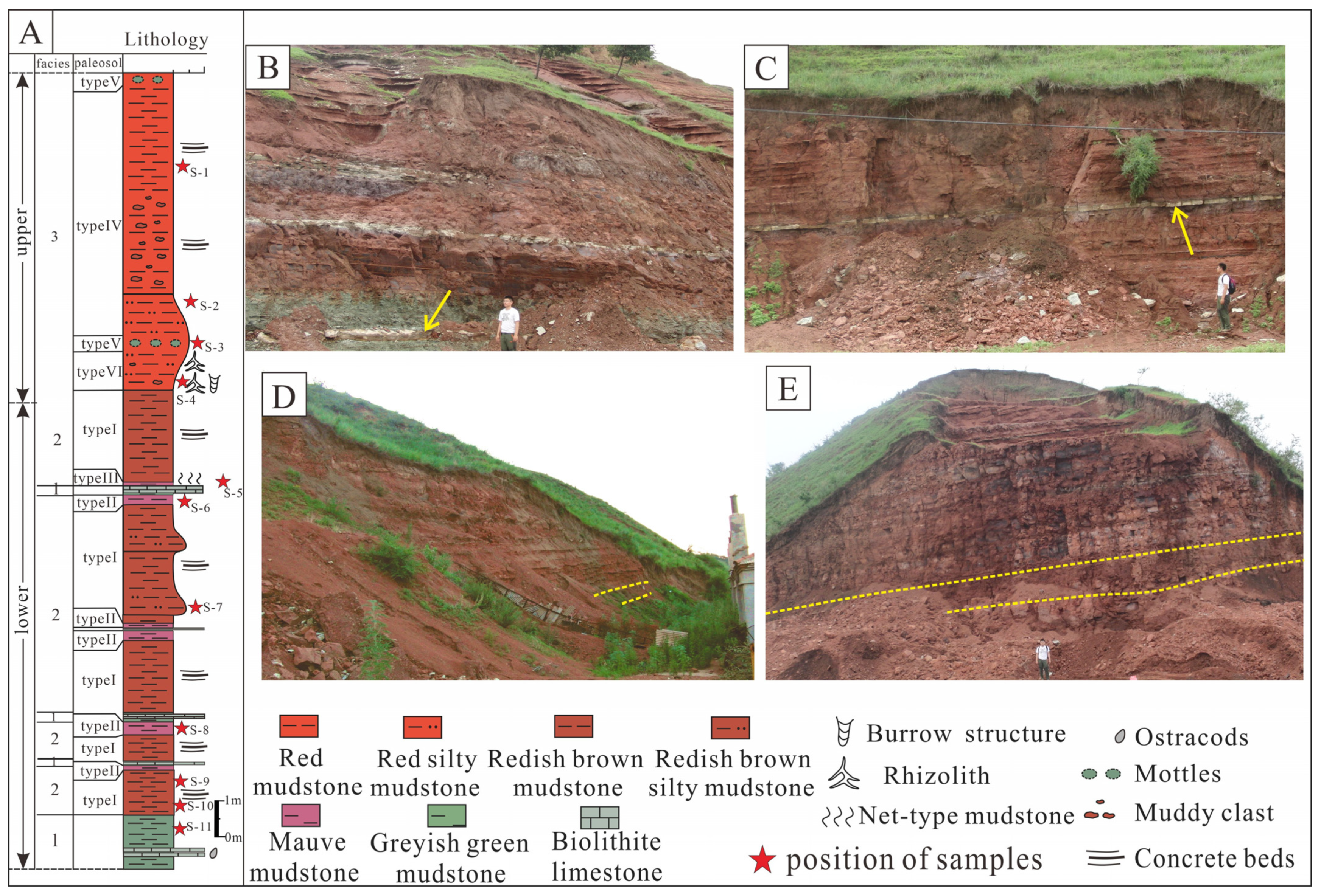
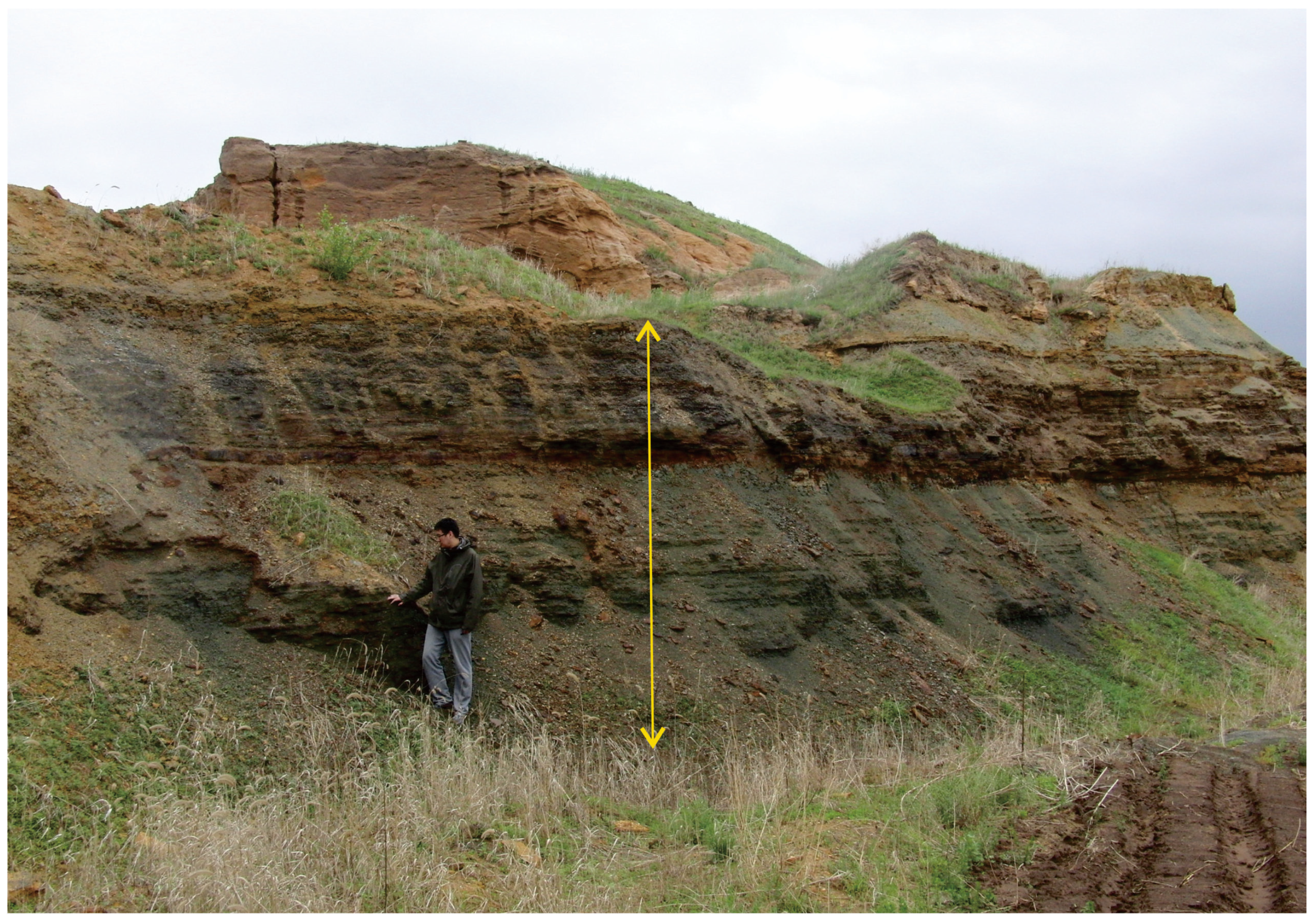
4.1. Facies Description and Interpretation
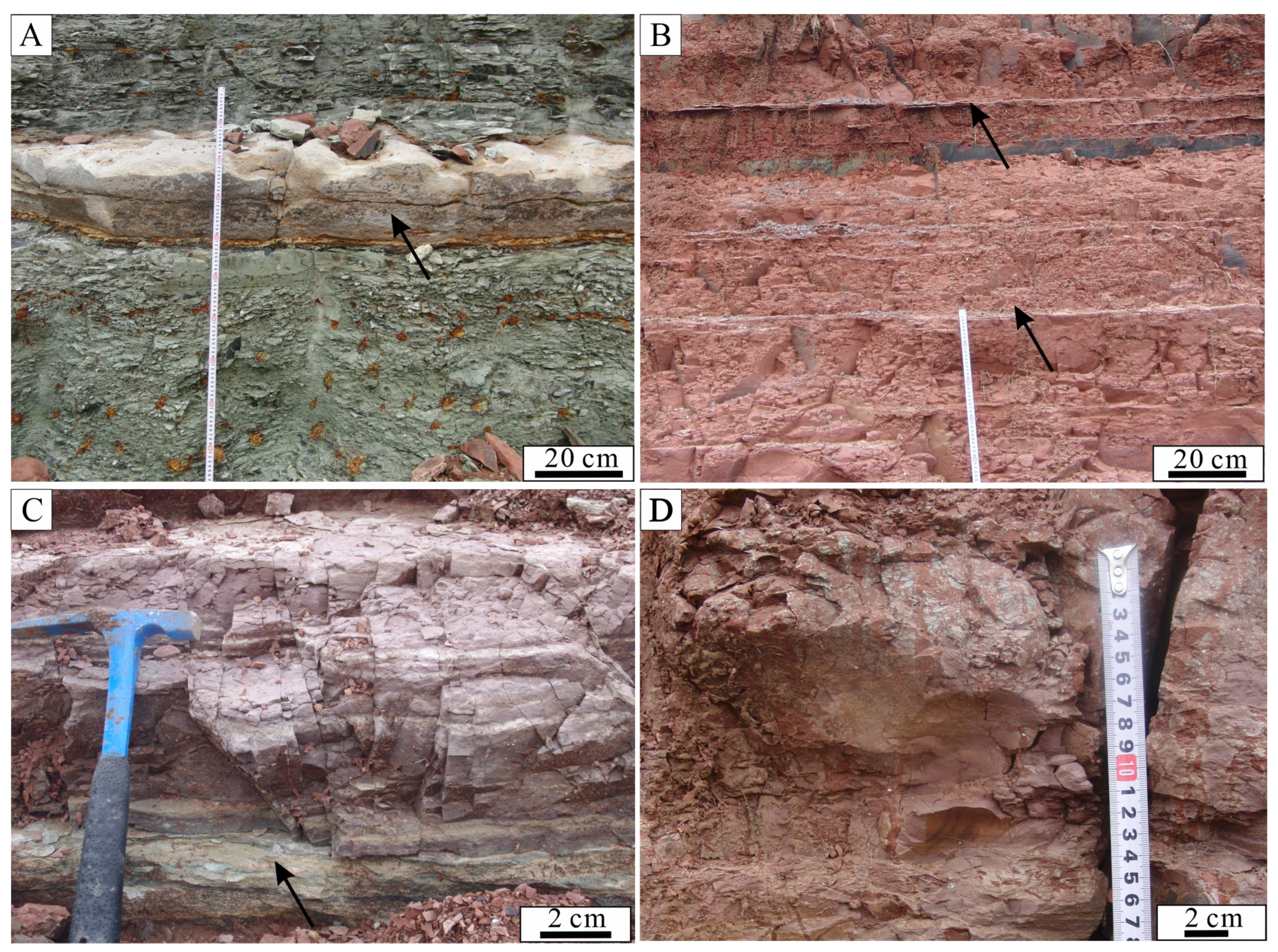
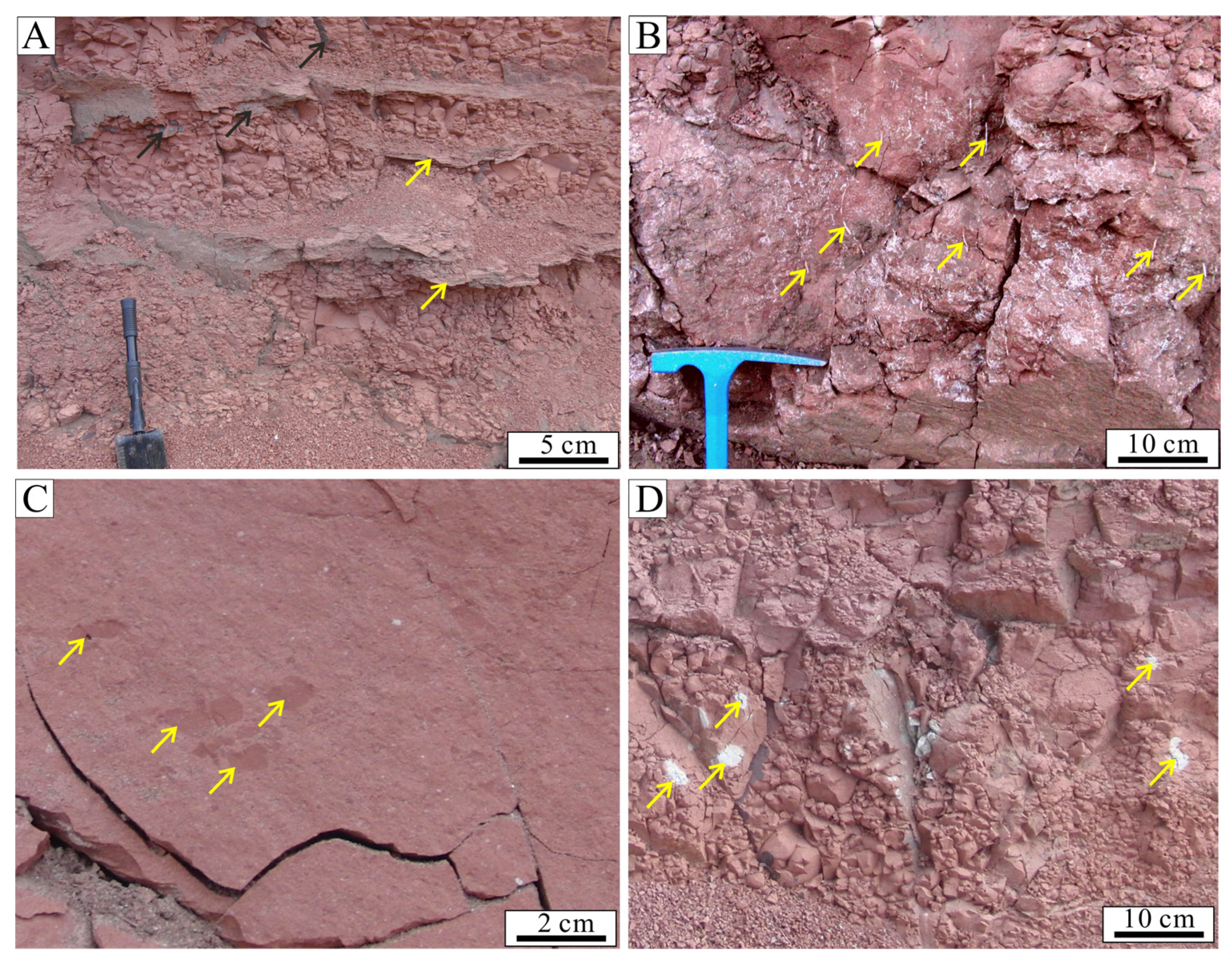
The stratigraphic columns were described in detail to identify vertical variations of different facies in the lower part of the Yaojia Formation (Figure 2A). Different types of facies in the red bed deposits vary in lithology, primary sedimentary structures, and fossils (Figure 2B,C). Features of paleosols in outcrops including rhizoliths, pedogenic carbonate, burrows, and the development of paleosol structures are also described in different facies (Figure 2D,E). Depositional environments of the red bed succession were described from the description and interpretation of different facies.

4.1.1. Facies 1

Description

Facies 1 consists of grayish-green mudstone and centimeter-thick ostracod limestone beds in outcrops (Figure 2A,B). There are abrupt contacts between the grayish-green mudstone in Facies 1 and reddish mudstone in other facies. Ostracod limestones develop as occasionally thin interbeds in the grayish-green mudstone (Figure 3A) and cannot be found in reddish mudstone. The thickness of the ostracod limestone varies from 10 to 20 cm with abundant shells of ostracods.

Interpretation

The ostracod-bearing limestone and the underlying grayish-green mudstone in facies 1 indicates mass mortality events of ostracods in a subaqueous reducing environment [39]. The abrupt contact between the celadon mudstone and reddish mudstone indicates an abrupt change of the sedimentary conditions. The ostracod limestone intercalations indicate mass mortality events, which were most probably caused by a fluctuating paleo lake level in a semi-arid climate [39]. The disappearance of the ostracod limestone layer from the red deposits indicates a gradual shrinking of the range of the subaqueous environment. According to previous study of the Songliao Basin [29]. shallow and semi-deep lakes were favorable environments for ostracod survival. In this study, the celadon mudstone with ostracod-bearing limestone associated with reddish deposits indicated a short-lived shallow water environment influenced by the variation of lake level. Thus, facies 1 suggests a shallow lake depositional environment.

4.1.2. Facies 2

Description

Facies 2 is located at lower parts of the outcrops, consisting of mauve, reddish-brown mudstone and silty mudstone (Figure 2B,C). There are several layers of mauve mudstone (Figure 3D) under the deposits of facies 1. The deposits of Facies 1 develop as interbeds in the reddish-brown mudstone of facies 2. There are three types of paleosols in facies 2. Type I is characterized by reddish-brown mudstone with thin calcrete interbeds (Figure 3B). Type II is characterized by mauve mudstone in facies 2 associated with ostracod limestone layers in facies 1 (Figure 3C). Type III is characterized by net-type reddish-brown mudstone (Figure 3D). This type of red paleosol is distributed overlying the Type II paleosols in outcrops.

Interpretation

The overlying facies 2 deposits developed in a weak hydrodynamic environment mostly supplied with muddy sediments. The paleosols could be related to subaerial exposure in a warm seasonal paleoclimate [40]. The color of the mudstone changed to a reddish color, as the pedogenic processes increased the oxygen content [41]. Such a subaerial exposure process indicates fall of lake level. Facies 2 can be found developing in association with facies 1 in a vertical profile. Thus, facies 2 suggests an environment near a shallow lake influenced by a periodic fall of lake level named the lake margin [42].
The ostracod fossil remains in the lake margin mudstone indicate that it was once located in the short-lived subaqueous environment. The pedogenesis of the reddish-brown paleosols was controlled by the oxidizing environment, i.e., a relative low ground water table during low lake level. The appearance of paleosols indicates variation of the depositional environment. The calcrete beds in the reddish-brown paleosols indicate that the calcium in the soil dissolved and moved vertically, which is controlled by pedogenesis via seasonal precipitation in a semi-arid climate [43,44]. Type II paleosols developed in moderate to poorly drained conditions with a gleying process. The association of mauve paleosols and overlying ostracod limestone indicates a relatively high ground water table related to lake level. The type III paleosols suggests long exposure with groundwater leaching under periodic wetting and drying climate conditions [10].

4.1.3. Facies 3

Description

Facies 3 was found overlying the deposits of facies 2 from a vertical profile of outcrops (Figure 2D,E). These deposits of facies 3 consist of red silty mudstone (Figure 4A,B). Rhizoliths and burrows are also found in the red silty mudstone of facies 3 (Figure 4B). Angular millimeter to centimeter-sized muddy clasts were found near the erosion surface and in the red silty mudstones (Figure 4C). Fossils are rarely distributed in the red deposits.
Three types of paleosols are identified and described from the red silty mudstone in facies 3. Type IV paleosols are characterized by red paleosols with calcrete layers and manganese cutans. The calcrete bed intervals are more frequent here than those in the facies 2. The cutans consist of dark brown to black manganese oxides on fracture planes. Type V paleosols are characterized by red paleosols developed with mottles. Gradational boundaries can be observed between the mottles and the surrounding paleosol matrix. The mottles are circular to ellipsoidal with diameters of 2–5 cm in cross-section (Figure 4D).
Finally, in the facies 3 deposits, type VI paleosols are red and develop with rhizoliths and burrows. The rhizoliths occur primarily in the red silty mudstone with mud clasts and burrows (Figure 4D). The burrows are subvertically oriented in the paleosol profile with cylindrical vertical sections (Figure 4D). The burrows are 4–8 cm in length and 0.6–1 cm in diameter. The paleosol bed with rhizoliths is approximately 1 m in thickness. Rhizoliths are mainly in the form of white rhizotubules [45] and are distinguished by their color and loose texture from the surrounding paleosol matrix (Figure 4C). The rhizoliths are elongated and branch downward in the red paleosol with a circular cross-section, showing a morphology indicating plant root growth (Figure 5A). The rhizoliths are 1–5 mm in diameter, and the elongation can reach 10 to 20 mm. As shown by thin sections and SEM analyses, the rhizoliths are filled with calcite, analcime, and clay minerals. The rhizolith color differs greatly from the surrounding matrix. The analcime in the rhizoliths is characterized by euhedral and subhedral icositetrahedra (Figure 5B).

Interpretation

These angular mud-clasts-bearing deposits and erosion surfaces (Figure 4C) in the Yaojia Formation indicate reworking of previously deposited sediments in the flood plain influenced by sheet floods. In such a semi-arid climate condition, flood events are common in the mudflats because of highly fluctuating sedimentary discharge [46,47], the mud clasts in facies 3 can be seen as important evidence. The reddish color of the facies 3 deposits is related to the content of iron oxides generated from the exposure process [48]. In summary, facies 3 suggests a mudflats environment influenced by periodic exposure and periodic wetting and drying between the terminal extent of the fluvial deposits and lake margin area. This environment is dominated by fluvial flood events. Paleosols in the mudflat deposits (types IV, V, and VI) suggest long-period exposure and poorer drainage conditions in a semi-arid climate. Rhizoliths in type IV paleosols indicate plant growth status in the mudflats and alternating wetting and drying conditions in semi-arid periodic climates [40]. Root trace mineralogy (calcite and analcime) indicates an evaporative concentration process from evaporating soil water after roots decayed under dry climatic conditions [48,49]. The burrows in the type IV paleosols suggest traces of burrowing insects under relatively humid moisture condition [50,51]. The mottles in the type V paleosols indicate iron mobilization in the paleosol during the gleying process with alternating saturated and better drained conditions controlled by falling water tables (Kraus and Hasiotis, 2006). The calcrete beds and cutans in the type VI paleosols indicate seasonal precipitation that facilitated a leaching and subsequent illuviation process of calcium and manganese from the paleosol matrix in a semi-arid climate [43,44,45,51,52,53].

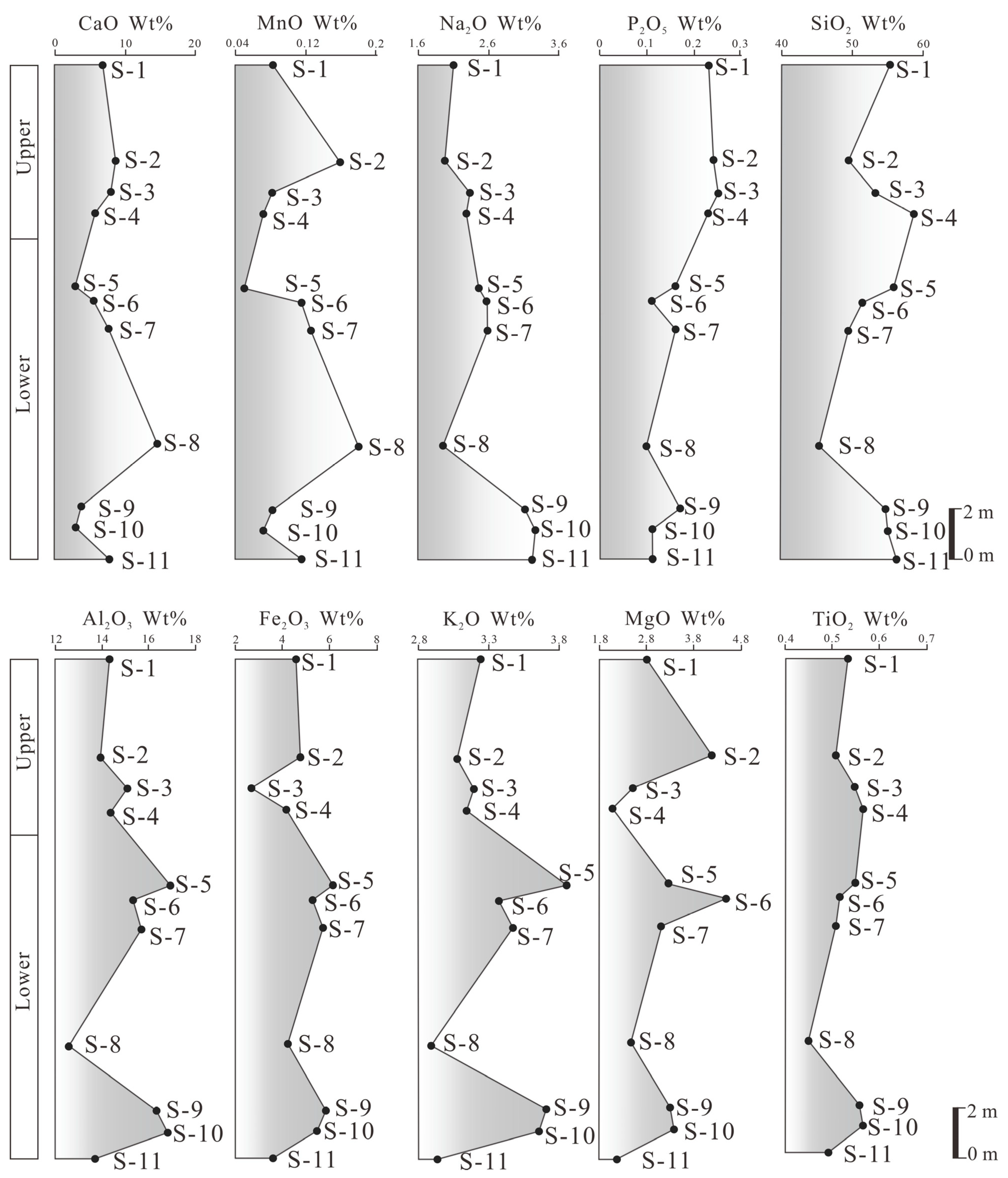
4.2. Elemental Geochemistry Characteristics of the Red Bed Sucssion with Paleosols

Chemical analysis of the major element provides indicators of pedogenetic and paleoclimatic information in the red bed succession. Major element values (Figure 6), in weight percent, were normalized to their molecular weight to calculate the chemical index of alteration without potassium (CIA-K*). MAP (mean annual precipitation) values in the paleosols were calculated from the CIA-K* index. The MAP (mm) values for the Yaojia Formation vary between 406.23 and 689.25 mm (Table 1). The vertical distribution of the MAP value is relatively stable in the Yaojia Formation. There is an upward increasing trend in the MAP values and an abrupt decrease in paleosols with rhizoliths (sample S4).
Although the content of trace elements is low in sedimentary rocks, they provide important implication in the study of pedogenesis of paleosol and paleoclimate [34,54]. Under the more intense chemical weathering conditions, the Rb/Sr ratio increases, whereas the Sr/Ba ratio and Sr/Cu ratio decrease, as the decreasing amount of Sr is governed by the leaching process in paleosols [54,55]. Analysis of trace elements provides information for intensities of weathering and pedogenesis. In this study, the intensity fluctuation of chemical weathering was determined by analyzing vertical changes of the ratio of trace elements (Sr/ Cu, Rb/Sr, and Sr/ Ba) from samples in the red bed succession in outcrop. The values of the Sr/Cu ratio, Rb/Sr ratio, and Sr/Ba ratio in sedimentary rocks have been widely used to reflect variation of paleoclimate, because Sr is more soluble and readily leached than either Cu, Rb, or Ba from paleosols [48]. As shown in Table 2, the values of the Rb/Sr ratio vary from 0.19 to 0.48, with an average of 0.30. The values of the Sr/Cu ratio vary from 12.80 to 29.77, with an average of 18.85. The values of the Sr/Ba ratio vary from 0.58 to 1.35, with an average of 0.96. (Table 2). The variations of the Rb/Sr ratio, Sr/Cu ratio, and Sr/Ba ratio in a vertical profile show similar geochemical behavior upward (Figure 7). The Rb/Sr ratio increase abruptly, whereas the Sr/Ba ratio and Sr/Cu ratio decrease abruptly in the paleosols with rhizoliths (type VI) and paleosols with net-type structure (type III) (Figure 7).

5. Discussions

5.1. Paleoenvironmental Transition of the Paleosols

In this study, we discover paleosols in outcrops developed in fluvial–lacustrine succession. Formation of the terrestrial red paleosols in the lake margin and mudflat was controlled by the deposition and pedogenesis processes. The MAP value of the paleosols indicates a semi-arid paleoclimate [56]. A gradually declining lake level is recorded in the vertical variation of the sedimentary facies (Figure 8). The gradually disappearing ostracod fossils in the shallow lacustrine deposits indicate the shrinking process of the paleo lake. The shallow lake evolved to a lake margin, which was affected by fluctuation of lake level. Lake margin mudstone deposits experienced a long period of exposure in semi-arid climate and were transformed to red paleosols. Influenced by the decline in the lake level, the lake margin deposits change upward into the unique mudflat deposits, which were affected by flood events. The mudflat deposits experienced a long period of exposure and formed paleosols in semi-arid climate.

5.2. Tectonic Uplift Events Inferred from the Paleosols

Red paleosols in many cases are generally considered to develop in warm and semi-arid paleoclimates [40,45]. Tectonic uplift is considered as another important controlling factor for formation of the red paleosols. The dark shale deposits in the lower Qingshankou Formation were deposited in a deep or sub-deep lake environment (Figure 9). During the time of the earlier Qingshankou Formation, the Paleo Songliao Lake has a large lake range (Figure 10A). Then, the Paleo Songliao Lake began to decrease (Figure 10B). At the time of deposition of the K2y1, the paleo lacustrine area decreased and reached a minimum range after the deposition of the underlying Qingshankou Formation (Figure 10C), which coincides with the global greenhouse period during the Turonian [10,32].
The collision of the Okhotomorsk Block with East Asia resulted in tectonic uplift [22,24,48]. (Figure 10D). The tectonic uplift controlled the formation of unconformity surface (T11) at approximately 88Ma–86 Ma [24]. In this study, the tectonic uplift process in East Asia can be identified from the evolution of drainage conditions inferred from different types of paleosols. Paleosols in the lake margin deposits (types I, II, and III) suggest exposure and pedogenetic processes with influence of lake level fluctuation in a semi-arid climate. There is a good link between the depositional environment of the host deposits and drainage conditions of the red paleosols controlled by the position of the ground water table. The paleosol of the mudflats formed under well-drained conditions below the ground water level. The paleosols of the lake margin deposits formed in well and moderately drained conditions below the ground water level closer to the water table than that in the mudflats. The variation of the chemical weathering conditions of the paleosols indicates that the pedogenesis process was strong and was controlled by the tectonic uplift. The abrupt change of the trace elements’ variations shown in the paleosols indicates intense and long-lived chemical weathering conditions. That can be seen as evidence in the paleosols that indicates sedimentary response to the tectonic uplift event.

6. Conclusions

Based on sedimentary descriptions, geochemical analyses, and micromorphology examinations, the depositional environment and paleoclimate of the red bed deposits and paleosols are interpreted in the Late Cretaceous continental red beds in the Songliao Basin, NE China. The main conclusions are listed as follows.
(1) This study finds that the red bed deposits in outcrops of the Yaojia Formation developed in mudflat and shallow lacustrine margin environments confined to marginal areas. Sheet flood events affected the mudflat area with highly fluctuating water discharge.
(2) Five types of red paleosols are intercalated in the red bed deposits, which are controlled by depositional and pedogenesis processes. The relationship between depositional environments and paleosols, from lake margin to mudflat, indicates variations in the drainage condition with respect to the ground water table from lake margin to mudflat.
(3) According to geochemical analyses, the paleosols were formed under a stable semi-arid paleoclimate and landscape that was controlled by tectonic uplift coincident with the collision of the Okhotomorsk Block with East Asia at approximately 88–86 Ma. Tectonic uplift, fluctuating precipitation, abrupt sheet floods, periodic wetting and drying, and plant–soil interactions in the deposits of the Yaojia Formation provide a detailed picture that can be used to reconstruct part of the Late Cretaceous greenhouse world in mid-latitude regions.

Author Contributions

Conceptualization, L.D. and L.Z.; Investigation, L.Z.; Methodology, L.D.; Supervision, C.Z. All authors have read and agreed to the published version of the manuscript.

Funding

This research was funded by the Young Scientists Fund of the National Natural Science Foundation of China (Grant No. 41902122) and the Postdoctoral Innovation Post of Hubei Province, China (Grant No. 9621000813).

Data Availability Statement

Not applicable.

Acknowledgments

The authors thank Li Yingjiu, Zang Dongsheng, Liu Wei and Yingzhuo Cao for their help in field research, and they also thank Liang Ting for all the helpful suggestions for the original manuscript.

Conflicts of Interest

The authors declare no conflict of interest.

References

  1. Alonso-Zarza, A.M.; Zhao, Z.; Song, C.H.; Li, J.J.; Zhang, J.; Martín-Pérez, A.; Martín-García, R.; Wang, X.X.; Zhang, Y.; Zhang, M.H. Mudflat/distal fan and shallow lake sedimentation (upper Vallesian-Turolian) in the Tianshui basin, central China: Evidence against the late Miocene eolian loess. Sediment. Geol. 2009, 222, 42–51. [Google Scholar] [CrossRef] [Green Version]
  2. Aziz, H.A.; Sans-Rubio, E.; Calvo, J.P.; Hilgen, F.J.; Krijgsman, W. Palaeoenvironmental reconstruction of a middle Miocene alluvial fan to cyclic shallow lacustrine depositional system in the Calatayud Basin (NE Spain). Sedimentology 2003, 50, 211–236. [Google Scholar] [CrossRef] [Green Version]
  3. Basilici, G.; Bo, P.F.D.; De Oliveira, E.F. Distribution of palaeosols and deposits in the temporal evolution of a semiarid fluvial distributary system (Bauru Group, Upper Cretaceous, SE Brazil). Sediment. Geol. 2016, 341, 245–264. [Google Scholar] [CrossRef]
  4. Bice, K.L.; Birgel, D.; Meyers, P.A.; Dahl, K.A.; Hinrichs, K.U.; Norris, R.D. A multiple proxy and model study of Cretaceous upper ocean temperatures and atmospheric CO2 concentrations. Paleoceanography 2006, 21, PA2002. [Google Scholar] [CrossRef] [Green Version]
  5. Brewer, R. Fabric and Mineral Analysis of Soils. Robert, E., Ed.; Krieger Publishing Company: New York, NY, USA, 1976; pp. 434–444. [Google Scholar]
  6. Cao, H.; Guo, W.; Shan, X.; Ma, L.; Sun, P. Paleolimnological environments and organic accumulation of the Nenjiang Formation in the southeastern Songliao Basin. China Oil Shale 2015, 32, 5–24. [Google Scholar] [CrossRef] [Green Version]
  7. Catena, A.M.; Hembree, D.I.; Saylor, B.Z.; Anaya, F.; Croft, D.A. Paleoenvironmental analysis of the neotropical fossil mammal site of cerdas, Bolivia (middle Miocene) based on ichnofossils and paleopedology. Palaeogeogr. Palaeoclimatol. Palaeoecol. 2016, 459, 423–439. [Google Scholar] [CrossRef] [Green Version]
  8. Chamberlain, C.P.; Wan, X.; Graham, S.A.; Carroll, A.R.; Doebbert, A.C.; Sageman, B.B.; Blisniuka, P.; Kent-Corson, M.L.; Wang, Z.; Wang, C.S. Stable isotopic evidence for climate and basin evolution of the late Cretaceous Songliao Basin, China. Palaeogeogr. Palaeoclimatol. Palaeoecol. 2013, 385, 106–124. [Google Scholar] [CrossRef]
  9. Chen, J.; An, Z.; Wang, Y.; Ji, J.; Yang, C.; Lu, H. Distribution of rb and sr in the luochuan loess—paleosol sequence of china during the last 800 ka. Sci. China 1999, 42, 225–232. [Google Scholar] [CrossRef]
  10. Dal’Bó, P.F.F.; Basilici, G.; Angélica, R.S. Factors of paleosol formation in a Late Cretaceous eolian sand sheet paleoenvironment, Marília Formation, southeastern Brazil. Palaeogeogr. Palaeoclimatol. Palaeoecol. 2010, 292, 349–365. [Google Scholar] [CrossRef]
  11. Du, X.B.; Xie, X.N.; Lu, Y.C.; Ren, J.; Zhang, S.; Lang, P.; Chen, T.; Su, M.; Zhang, C. Distribution of continental red paleosols and their forming mechanisms in the Late Cretaceous Yaojia Formation of the Songliao Basin, NE China. Cretac. Res. 2011, 32, 244–257. [Google Scholar] [CrossRef]
  12. Feng, Z.Q.; Jia, C.Z.; Xie, X.N. Tectonostratigraphic units and stratigraphic sequences of the nonmarine Songliao Basin, Northeast China. Basin Res. 2010, 22, 79–95. [Google Scholar]
  13. Gao, Y.; Ibarra, D.E.; Wang, C.; Caves, J.K.; Chamberlain, C.P.; Graham, S.A.; Wu, H.C. Mid-latitude terrestrial climate of East Asia linked to global climate in the Late Cretaceous. Geology 2015, 43, 287–290. [Google Scholar] [CrossRef]
  14. Goldberg, K.; Humayun, M. The applicability of the chemical index of alteration as a paleoclimatic indicator; an example from the Permian of the Parana Basin, Brazil. Palaeogeogr. Palaeoclimatol. Palaeoecol. 2010, 293, 175–183. [Google Scholar] [CrossRef]
  15. Hatano, N.; Yoshida, K. Sedimentary environment and paleosols of middle Miocene fluvial and lacustrine sediments in central Japan: Implications for paleoclimate interpretations. Sediment. Geol. 2016, 347, 117–129. [Google Scholar] [CrossRef] [Green Version]
  16. Huang, C.M.; Retallack, G.J.; Wang, C.S. Cretaceous calcareous paleosols: Pedogenetic characteristics and paleoenvironmental implications. Acta Pedol. Sin. 2010, 47, 1029–1038. [Google Scholar]
  17. Jones, M.M.; Ibarra, D.E.; Gao, Y.; Sageman, B.B.; Selby, D.; Chamberlain, C.P.; Graham, S.A. Evaluating Late Cretaceous OAES and the influence of marine incursions on organic carbon burial in an expansive East Asian paleo-lake. Earth Planet. Sci. Lett. 2018, 484, 41–52. [Google Scholar] [CrossRef] [Green Version]
  18. Klappa, C.F. Rhizoliths in terrestrial carbonates: Classification, recognition, genesis, and significance. Sedimentology 1980, 27, 613–629. [Google Scholar] [CrossRef]
  19. Kottek, M.; Grieser, J.; Beck, C.; Rudolf, B.; Rubel, F. World map of the Köppen-Geiger climate classification updated. Meteorol. Z. 2006, 15, 259–263. [Google Scholar] [CrossRef]
  20. Kraus, M.J.; Hasiotis, S.T. Significance of different modes of rhizolith preservation to interpreting paleoenvironmental and paleohydrologic settings: Examples from Paleogene paleosols, Bighorn Basin, Wyoming, USA. J. Sediment. Res. 2006, 76, 633–646. [Google Scholar] [CrossRef]
  21. Li, C.; Liu, S.F. Cretaceous anomalous subsidence and its response to dynamic topography in the Songliao Basin, Northeast China. J. Asian Earth Sci. 2015, 109, 86–99. [Google Scholar] [CrossRef]
  22. Li, J.; Wen, X.Y.; Huang, C.M. Lower Cretaceous paleosols and paleoclimate in Sichuan basin, China. Cretac. Res. 2016, 62, 154–171. [Google Scholar] [CrossRef]
  23. Li, Z.D.; Zhang, L.S.; Were, P.; Wang, D.J. Sedimentary characteristics of 1st member of Yaojia formation in Zhaoyuan-Taipingchuan region of Songliao basin. J. Pet. Sci. Eng. 2017, 148, 52–63. [Google Scholar] [CrossRef]
  24. Maynard, J.B. Chemistry of modern soils as a guide to interpreting Precambrian paleosols. J. Geol. 1992, 100, 279–289. [Google Scholar] [CrossRef]
  25. Mc Lennan, S.M. Weathering and Global Denudation. J. Geol. 1993, 101, 295–303. [Google Scholar] [CrossRef]
  26. Mc Bride, E.F. Significance of color in red, green, purple, olive, brown, and gray beds of Difunta Group, Northeastern Mexico. J. Sediment. Res. 1974, 44, 760–773. [Google Scholar]
  27. Meng, Q.; Zhang, S.; Sun, G.; Fu, X.; Chao, W.; Yao, S. A seismic geomorphology study of the fluvial and lacustrine-delta facies of the Cretaceous Quantou-Nenjiang Formations in Songliao Basin, China. Mar. Pet. Geol. 2016, 78, 836–847. [Google Scholar]
  28. Owen, R.A.; Owen, R.B.; Renaut, R.W.; Scott, J.J.; Jones, B.; Ashley, G.M. Mineralogy and origin of rhizoliths on the margins of saline, alkaline lake Bogoria, Kenya rift valley. Sediment. Geol. 2008, 203, 143–163. [Google Scholar] [CrossRef]
  29. Pan, S.; Liang, S.; Ma, L.; Liu, C.; Liu, H. Genesis, distribution, and hydrocarbon implications of ostracod-bearing beds in the Songliao basin (NE China). Aust. J. Earth Sci. 2017, 64, 793–806. [Google Scholar] [CrossRef]
  30. Retallack, G.J. Pedogenic carbonate proxies for amount and seasonality of precipitation in paleosols. Geology 2005, 33, 333–336. [Google Scholar] [CrossRef]
  31. Retallack, G.J. The oldest known paleosol profiles on Earth: 3.46 Ga Panorama Formation, Western Australia. Palaeogeogr. Palaeoclimatol. Palaeoecol. 2018, 489, 230–248. [Google Scholar] [CrossRef]
  32. Retallack, G.J. Early forest soils and their role in Devonian global change. Science 1997, 276, 583–585. [Google Scholar] [CrossRef] [Green Version]
  33. Shao, L.Y.; He, Z.P.; Lu, J. Sequence Stratigraphy and Coal Accumulation of the Carboniferous and Permian in the Western Peri-Bohai Bay Area of the northern China; Geological Publishing House: Beijing, China, 2008; pp. 124–158. [Google Scholar]
  34. Sheldon, N.D.; Tabor, N.J. Quantitative paleoenvironmental and paleoclimatic reconstruction using paleosols. Earth Sci. Rev. 2009, 95, 1–52. [Google Scholar] [CrossRef]
  35. Sheldon, N.D.; Retallack, G.J.; Tanaka, S. Geochemical climofunctions from North American soils and application to palaeosols across the Eocene-Oligocene boundary in Oregon. J. Geol. 2002, 110, 687–696. [Google Scholar] [CrossRef] [Green Version]
  36. Skelton, P.W.; Spicer, R.A.; Kelley, S.P.; Gilmour, I. The Cretaceous World; Cambridge University Press: Cambridge, UK, 2003; pp. 1–12. [Google Scholar]
  37. Smith, J.J.; Hasiotis, S.T.; Kraus, M.J.; Woody, D.T. Relationship of floodplain ichnocoenoses to paleopedology, paleohydrology, and paleoclimate in the Willwood Formation, Wyoming, during the Paleocene-Eocene thermal maximum. Palaios 2008, 23, 683–699. [Google Scholar] [CrossRef]
  38. Smith, J.J.; Hasiotis, S.T.; Kraus, M.J.; Woody, D.T. Naktodemasis bowni: New ichnogenus and ichnospecies for adhesive meniscate burrows (AMB), and paleoenvironmental implications, Paleogene Willwood Formation, Bighorn Basin, Wyoming. J. Paleontol. 2008, 82, 267–278. [Google Scholar] [CrossRef]
  39. Soares, M.V.T.; Basilici, G.; Lorenzoni, P.; Colombera, L.; Mountney, N.P.; Martinelli, A.G.; Mesquita, Á.F.; Marinho, T.S.; García, R.G.V.; Marconato, A. Landscape and depositional controls on palaeosols of a distributive fluvial system (Upper Cretaceous, Brazil). Sediment. Geol. 2020, 410, 105774. [Google Scholar] [CrossRef]
  40. Song, Y.; Ren, J.; Stepashko, A.A.; Li, J. Post-rift geodynamics of the Songliao Basin, NE china: Origin and significance of T11 (Coniacian) unconformity. Tectonophysics 2014, 634, 1–18. [Google Scholar] [CrossRef]
  41. Therrien, F. Palaeoenvironments of the latest Cretaceous (Maastrichtian) dinosaurs of Romania: Insights from fluvial deposits and paleosols of the Transylvanian and Hateg basins. Palaeogeogr. Palaeoclimatol. Palaeoecol. 2005, 218, 15–56. [Google Scholar] [CrossRef]
  42. Varela, A.N.; Raigemborn, M.S.; Richiano, S.; White, T.; Poiré, D.G.; Lizzoli, S. Late Cretaceous paleosols as paleoclimate proxies of high-latitude southern hemisphere: Mata Amarilla formation, Patagonia, Argentina. Sediment. Geol. 2018, 363, 83–95. [Google Scholar] [CrossRef]
  43. Zaman, M.A.; Rahman, A.; Haddad, K. Regional flood frequency analysis in arid regions: A case study for Australia. J. Hydrol. 2012, 475, 74–83. [Google Scholar] [CrossRef]
  44. Zhang, L.; Bao, Z.D.; Lin, Y.; Chen, Y.; Dou, L.; Kong, B. Genetic types and sedimentary model of sandbodies in a shallow-water delta: A case study of the first Member of Cretaceous Yaojia Formation in Qian’an area, south of Songliao Basin, NE China. Pet. Explor. Dev. 2017, 44, 770–779. [Google Scholar] [CrossRef]
  45. Yang, L.J.; Shao, L.Y.; Zhang, P.F. Palaeosols: Types and recognition. Coal Geol. China 2002, 14, 1–3. [Google Scholar]
  46. Wan, X.Q.; Zhao, J.; Scott, R.W.; Wang, P.J.; Feng, Z.H.; Huang, Q.H.; Xi, D.P. Late Cretaceous stratigraphy, Songliao Basin, NE China: SK1 cores. Palaeogeogr. Palaeoclimatol. Palaeoecol. 2013, 385, 31–43. [Google Scholar] [CrossRef]
  47. Wang, C.S.; Scott, R.W.; Wan, X.Q.; Graham, S.A.; Huang, Y.J.; Wang, P.J.; Wu, H.C.; Dean, W.E.; Zhang, L.M. Late cretaceous climate changes recorded in Eastern Asian lacustrine deposits and North American epieric sea strata. Earth-Sci. Rev. 2013, 126, 275–299. [Google Scholar] [CrossRef]
  48. Wang, C.S.; Feng, Z.Q.; Zhang, L.M.; Huang, Y.; Cao, K.; Wang, P.; Zhao, B. Cretaceous paleogeography and paleoclimate and the setting of SKI borehole sites in Songliao Basin, northeast China. Palaeogeogr. Palaeoclimatol. Palaeoecol. 2013, 385, 17–30. [Google Scholar] [CrossRef]
  49. Wu, H.C.; Zhang, S.H.; Jiang, G.Q.; Hinnov, L.; Yang, T.; Li, H.; Wan, X.; Wang, C. Astrochronology of the Early Turonian-Early Campanian terrestrial succession in the Songliao Basin, northeastern China and its implication for long-period behavior of the Solar System. Palaeogeogr. Palaeoclimatol. Palaeoecol. 2013, 385, 55–70. [Google Scholar] [CrossRef]
  50. Xi, D.P.; Wan, X.Q.; Jansa, L. Late Cretaceous paleoenvironment and lake level fluctuation in the Songliao Basin, northeastern China. Isl. Arc 2011, 20, 6–22. [Google Scholar] [CrossRef]
  51. Xue, J.; Deng, Z.; Huang, P.; Huang, K.; Benton, M.J.; Cui, Y.; Wang, D.; Liu, J.; Shen, B.; Basinger, J.F.; et al. Belowground rhizomes in paleosols: The hidden half of an early Devonian vascular plant. Proc. Natl. Acad. Sci. USA 2016, 113, 9451–9456. [Google Scholar] [CrossRef] [Green Version]
  52. Yang, Y.T. An unrecognized major collision of the Okhotomorsk block with east Asia during the late Cretaceous, constraints on the plate reorganization of the northwest Pacific. Earth-Sci. Rev. 2013, 126, 96–115. [Google Scholar] [CrossRef]
  53. Zhang, L.M.; Wang, C.; Cao, K.; Wang, Q.; Tan, J.; Gao, Y. High elevation of Jiaolai Basin during the Late Cretaceous: Implication for the coastal mountains along the East Asian margin. Earth Planet. Sci. Lett. 2016, 456, 112–123. [Google Scholar] [CrossRef]
  54. Zhang, L.; Bao, Z.D.; Dou, L.; Wang, H.; Ji, Y. New Discovery of Red Paleosols with Calcite and Zeolitic Rhizoliths in the Late Cretaceous Yaojia Formation, Southern Songliao Basin, NE China. Acta Geol. Sin. 2018, 92, 2462–2463. [Google Scholar]
  55. Zhang, L.; Bao, Z.D.; Zhang, C.M.; Dou, L.X.; Fu, P.; Zhao, J.H.; Wang, W.X. Paleosols in an outcrop of red beds from the Upper Cretaceous Yaojia Formation, southern Songliao Basin, Jilin Province, NE China. J. Palaeogeogr. 2020, 3, 353–362. [Google Scholar] [CrossRef]
  56. Zhao, J. A new geological theory about eluvial zone-Theory illuvial on depth of CaCO3. Acta Sedimentol. Sin. 2000, 18, 29–35. [Google Scholar]
Figure 1. (A) Map showing tectonic units of the Songliao Basin and location of the field outcrops of K2y1. I, western slope zone; II, northern plunge zone; III, central depression zone; III1, Heiyupao Sag; III2, Mingshui Terrace; III3, Honggang Terrace; III4, Qijiagulong Sag; III5, Daqing Anticline; III6, Sanzhao Sag; III7, Chaoyanggou Terrace; III8, Changling Sag; III9, Fuyu Uplift; III10, Shuangtuozi Terrace; IV, northeastern uplift zone; V, southeastern uplift zone; VI, southwestern uplift zone. (B) Composite stratigraphic column of the Upper Cretaceous Yaojia Formation and Qingshankou Formation in the southern Songliao Basin (modified from [24,27,32]). The red arrow shows K2y1, the focus in this study. (C) Geological section in NW-SE direction (modified from [10]). See the location in (A).
Minerals 11 00993 g001
Figure 2. Measured section of the K2y1 in outcrops. (A) Sedimentary column of sections containing different types of facies and paleosols. (B,C) Overall characteristics of facies 1 and facies 2 in the lower part of the section with an ostracod layer marked by an arrow. (D,E) Overall characteristics of facies 3 in the upper part of the section; the rhizoliths are marked with yellow dotted lines (modified after [38]).
Minerals 11 00993 g002
Figure 3. Sedimentary and pedogenesis characteristics of lake margin and shallow lake deposits. (A) Ostracod bearing limestone layer in celadon mudstone (marked with yellow arrow). (B) Reddish-brown paleosol with calcrete beds in lake margin facies (marked with black arrow). (C) Mauve mudstone and thin bedded limestone beds with a grayish-green mudstone interlayer (marked with black arrow). (D) Net-type paleosol with reticular, mottles marked with yellow arrow (modified after [27]).
Minerals 11 00993 g003
Figure 4. Photographs showing paleosol details in mudflat deposits of the Yaojia Formation. (A) Concrete beds in paleosols of facies 2 (marked with yellow arrows) and manganese cutans (marked with black arrows) in paleosols. (B) Rhizoliths marked with yellow arrows in red paleosols. (C) Mud clasts in the red silty mudstone (D) Mottles marked by yellow arrows in the red paleosols.
Minerals 11 00993 g004
Figure 5. Detailed morphology of rhizoliths of the Yaojia Formation in rock samples. (A) Rhizoliths in reddish silty mudstone under plane polarized light (marked by blue circle), (B) SEM photomicrograph of euhedral analcime in rhizoliths.
Minerals 11 00993 g005
Figure 6. Vertical variations of major elements in the measured section of the Yaojia Formation. See Figure 2A for the location of the samples.
Minerals 11 00993 g006
Figure 7. Vertical variations of values of trace elements and elemental geochemical parameters in the measured section of the Yaojia Formation. The variation of relative lake level is interpreted from the sedimentary facies. See Figure 2 for the symbols.
Minerals 11 00993 g007
Figure 8. Conceptual sedimentary model showing the depositional environment variation and paleosol formation condition. (A) Shallow lake environments interpreted from the lower part of the field outcrop. (B) Shallow margin environments interpreted from the low part of the field outcrop. (C) Mudflat environments interpreted from the upper part of the field outcrop. (D) Sedimentary model showing the depositional environment and distribution of paleosols in the Yaojia Formation.
Minerals 11 00993 g008
Figure 9. Sedimentary characteristics of the K2qn in the outcrop underlying the Yaojia Formation, showing the dark shales formed in a deep or subdeep lake. An overall look of the outcrop marked by the yellow arrows. The deposits are covered by quaternary fluvial sediments showing characteristics of dunes.
Minerals 11 00993 g009
Figure 10. Depositional environmental variation in the Songliao Basin from the Qingshankou Formation to the overlying Yaojia Formation, showing shrinking of the paleo lake. (A) Paleo Songliao lake range in K2qn1. (B) Paleo Songliao lake range in K2qn3. (C) Paleo Songliao lake range in K2y1. (D) Evolution of Okohotomorsk Block and relationship with the Songliao Basin in East Asia during 100 to 79 Ma (modified from [26,28,31]).
Minerals 11 00993 g010
Table 1. The amount of major oxides (wt %), LOI (loss on ignition) (%), CIA-K* (chemical index of alteration without potash), and MAP (mean annual precipitation) in rock samples. See the location of the samples in Figure 2A.
SampleAl2O3BaOCaOCr2O3TFe2O3K2OMgOMnONa2OP2O5SiO2SO3SrOTiO2LOI CIA-K*MAP
S114.340.066.82<0.014.573.242.810.082.100.2355.280.090.050.569.6948.37525.58
S213.940.058.52<0.014.773.084.170.151.980.2449.410.070.060.5312.7443.41480.88
S315.110.057.990.012.693.202.530.082.330.2553.250.130.040.5811.0245.97503.41
S414.420.075.740.024.173.142.090.072.290.2358.630.120.030.608.0451.37554.50
S516.940.042.90<0.016.143.863.260.052.460.1655.790.020.040.587.2461.77667.99
S615.320.045.49<0.015.283.394.470.112.580.1151.420.010.060.5411.1462.29674.26
S715.680.057.63<0.015.713.483.120.122.590.1649.510.020.040.5311.3663.52689.25
S812.600.0514.500.014.232.902.470.171.960.1045.290.040.040.4615.2949.89540.02
S916.320.053.77<0.015.813.713.300.083.110.1754.760.120.040.598.5046.15505.11
S1016.820.052.95<0.015.463.673.380.073.270.1155.050.080.030.608.2133.98406.23
S1113.740.067.31<0.013.602.962.190.113.230.1156.210.420.040.519.4556.39-
Table 2. The concentration of trace elements (ppm) and associated geochemical parameters. See the location of the samples in Figure 2A.
SampleBaCuRbSrSr/CuRb/SrSr/Ba
S140923.5103.043618.5530.2361.066
S238317.499.751829.7700.1921.352
S338222.098.141919.050.2341.097
S456419.7102.532516.4970.3150.576
S540521.1130.027012.7960.4810.667
S640624.0118.552321.7920.2271.288
S740918.3114.537520.4920.3050.917
S833822.796.933414.7140.2900.988
S938117.5125.537521.4290.3350.984
S1041221.7119.533015.2070.3620.801
S1143421.797.237017.0510.2630.853
Publisher’s Note: MDPI stays neutral with regard to jurisdictional claims in published maps and institutional affiliations.

