Abstract
This study explores the sedimentary environment and tectonic implications of the Upper Carboniferous Yanghugou Formation on the western margin of the Ordos Basin through the analysis of major elements, trace elements, and rare earth elements in 23 mudstone samples. The results indicate moderate chemical weathering conditions, as reflected in the Chemical Alteration Index (CIA) and Component Variability Index (ICV) values. Warm and humid paleoclimatic conditions are suggested by Rb/Sr, Sr/Cu, spore, and pollen fossil samples. The paleosalinity of the water is identified as a transitional phase of a brackish water environment based on Sr/Ba and Th/U ratios. Additionally, V/(V + Ni) and δU values imply a transitional phase of a weak oxidation–reduction environment for the water. In accordance with the La-Th-Sc, Th-Sc-Zr, Th-Co-Zr, (La/Yb)-∑REE, and (La/Th)-Hf discrimination diagrams, it is inferred that the study area is part of a continental marginal tectonic setting. The sediments are primarily derived from an upper-crust felsic source area. The sedimentary period of the Yanghugou Formation in the western margin of the basin is considered a marginal rift basin characterized by north–south compression and western rift extension. This setting is influenced by the active continental margin of the Alxa block and the passive continental margin of the Qilian–north Qinling orogenic belt.
1. Introduction
The sedimentary geochemical characteristics of clastic rocks in the western margin of the Ordos Basin offer valuable insights into the processes of source rock, spanning from weathering and denudation to sedimentary diagenesis. These geochemical features hold significant implications for understanding the tectonic significance, weathering conditions, and paleosedimentary environment of the source area. Furthermore, they provide a quantitative means to evaluate geological processes [1,2,3,4,5].
The western margin of the Ordos Basin boasts abundant oil and gas resources in the Upper Paleozoic, yet their development remains relatively low. Notably, the Yanghugou Formation in the basin’s western margin harbors a rich source rock with high exploration value. Previous research has extensively delved into various aspects of the Upper Paleozoic in the western margin of the Ordos Basin, encompassing tectonic evolution [6,7,8], sequence stratigraphy [9,10], paleogeographic characteristics [11], sedimentary systems [11,12,13], and reservoir characteristics [13,14,15,16]. However, the investigation of the sedimentary characteristics of the Yanghugou Formation in the Upper Carboniferous is comparatively limited. Wang et al. [17] identified the material sources for the Yanghugou Formation on the western margin of the basin, pinpointing the Alxa block, Yinshan block in the north, and the Qinling Qilian orogenic belt in the southwest and south as significant contributors. Zhao et al. [18] observed that the Yanghugou Formation predominantly comprises barrier coastal lagoon facies sediments. Yuan et al. [19] suggested a gradual transition in the sedimentary environment of the Yanghugou Formation from coastal lagoons to limited shallow seas from south to north. These studies offer valuable insights into the geological processes and paleoenvironment of the Yanghugou Formation in the western margin of the Ordos Basin.
The sedimentary period of the Yanghugou Formation in the western margin of the basin coincided with intense tectonic activity. The Carboniferous period of the North China block, situated between the middle and low latitudes north of the equator, experienced a hot, warm, and humid climate. During the sedimentary period of the Yanghugou Formation, the western margin of the Ordos Basin was part of the Qilian Sea area, and the sedimentary environment underwent frequent changes due to the influence of tectonic movements. The tectonic framework of the study area also played a significant role in influencing the source and sedimentary environment. However, the specific impact of the tectonic framework on the sedimentary environment is not yet well understood, requiring further research for a clearer understanding of this relationship. In this study, major, trace, and rare earth element analyses, along with spore pollen analysis on field profiles and core samples, were conducted. Through these analyses, two main objectives were achieved: (1) determining the sedimentary environment characteristics, including paleoclimate, paleosalinity, and redox conditions during the sedimentary period of the Upper Carboniferous Yanghugou Formation in the study area; and (2) analyzing the tectonic framework of the study area based on regional geological characteristics. By accomplishing these objectives, the study provided valuable insights and references for understanding the sedimentary environment and tectonic evolution of the Yanghugou Formation in the western margin region.
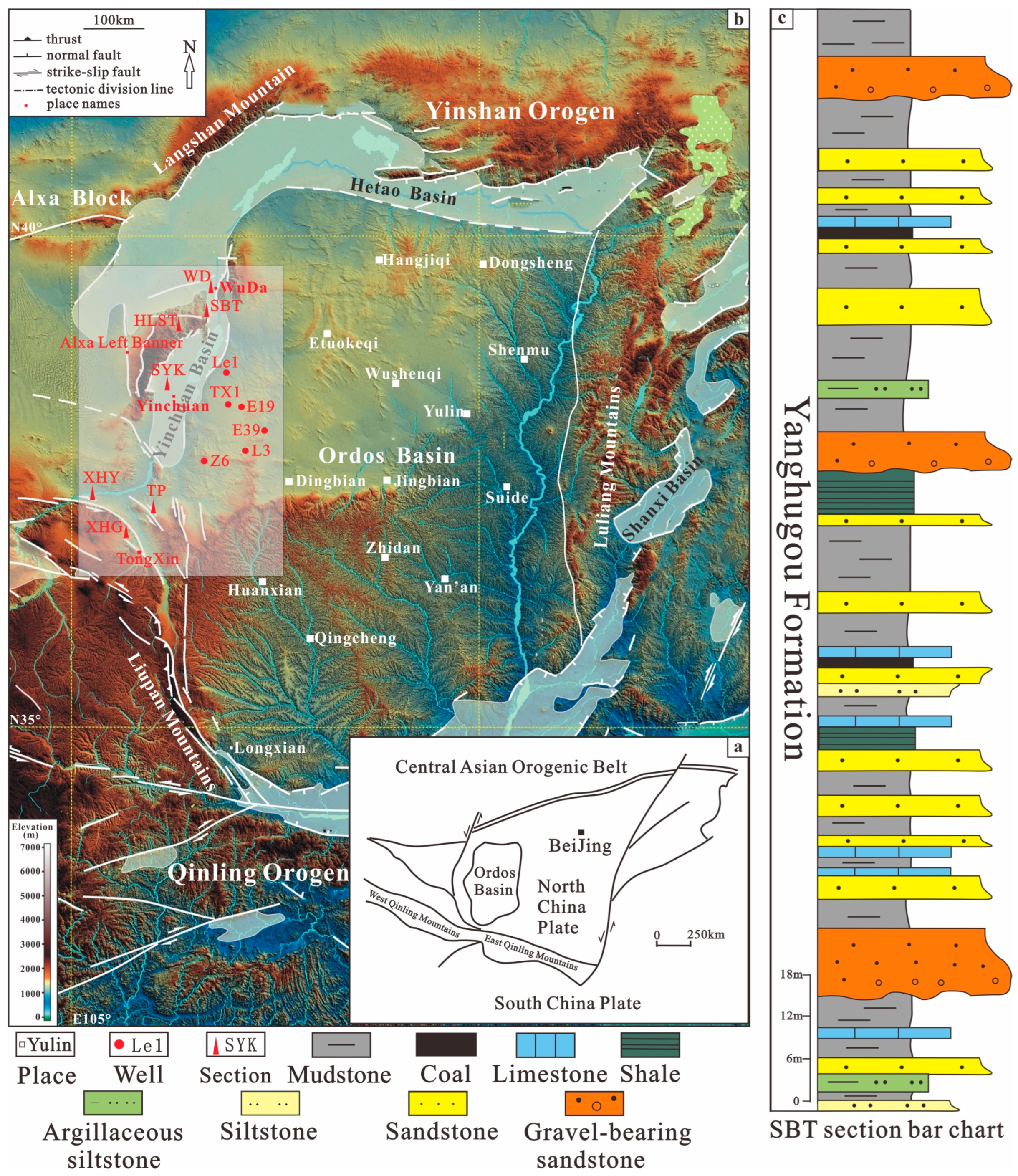
2. Geological Setting
The western margin of the Ordos Basin is situated in the western part of the North China craton and lies at the convergence point of three main geological entities: the Ordos block, Alxa block, and the Qinling Qilian orogenic belt. This region holds a unique tectonic position characterized by a complex sedimentary environment (Figure 1a,b). Prior to the Late Paleozoic Carboniferous period, both the Ordos block and the western margin of the basin underwent uplift and erosion due to the Caledonian tectonic movement. This uplifting and denudation event resulted in the absence of Middle-Upper Ordovician and Lower Carboniferous sedimentary deposits in the study area [6,7,8]. During the Caledonian orogeny, significant tectonic movements occurred in the study area. The South Qinling Ocean subducted northward along the Shangdan Fault, while the Xingmeng Trough subducted southward. The collision between the Qinqi block and the North China block led to the formation of a Caledonian fold belt along the southern margin of the North China block, encompassing the Qilian–North Qinling region. Compression from the Alxa block, Ordos block, and Qilian orogenic belt during this period resulted in the overall uplift of the region [11,12,13]. The Hercynian movement, also known as the Variscan orogeny, caused the reactivation of the “Helan Aulacogen”, a tectonic characteristic in the region. This movement led to deposition along the western margin of the Ordos Basin, while the central part of the basin experienced uplift and erosion.
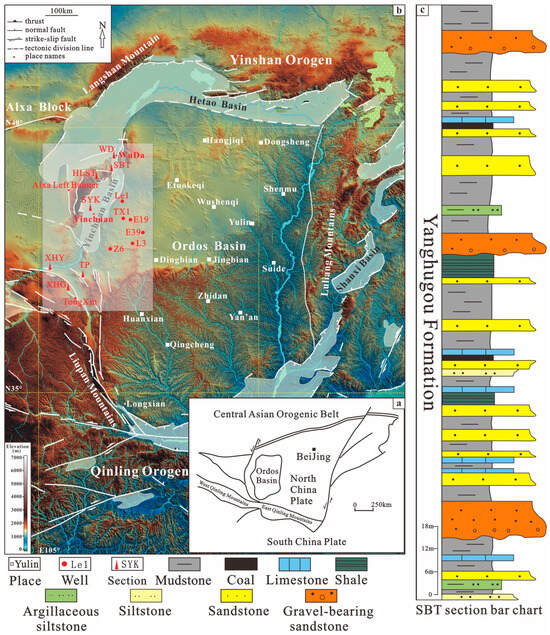
Figure 1.
(a) Regional tectonic location; (b) sample distribution; (c) Shanbatai (SBT) section lithologic histogram map.
The Carboniferous sedimentary strata in the Qilian Sea area on the western margin of the Ordos Basin can be stratigraphically divided from bottom to top into the Qianheishan Formation, Xiangniugou Formation, Jingyuan Formation, and Yanghugou Formation. The Carboniferous Qianheishan Formation and Xiangniugou Formation primarily consist of coarse clastic rocks and a substantial sequence of thick biogenic limestone. The lithology of the Jingyuan Formation is predominantly black shale, while the Yanghugou Formation exhibits gray-white quartz sandstone. Rhythmically interbedded within the Yanghugou Formation are gray-black siltstone and black mudstone, along with a minor occurrence of limestone and thin coal layers.
During the late Carboniferous period, specifically in the Yanghugou Formation, the western part of the study area exhibited a weakened basement with well-developed faults. The sedimentary strata in this region were substantial, ranging from 200 to 700 m, and displayed continuous development. In contrast, the eastern part of the study area, closer to the Ordos block, featured a relatively stable basement with sedimentary thickness typically less than 40 m. In the western part, the Yanghugou Formation predominantly contacts an underlying Ordovician unconformity, and it demonstrates notable variations in thickness. The formation is primarily composed of dark gray and grayish-black mudstone, silty mudstone, and sandstone, along with thin interbeds of mudstone and coal. The sedimentation of the Yanghugou Formation was influenced by the eastward progression of the Qilian Sea. Consequently, a barrier coastal sedimentary system evolved, characterized by barrier islands, tidal flats, and lagoons [9,20,21] (Figure 1c).
3. Material and Methods
All samples studied in the paper were collected from 7 field profiles and 6 internal drilling cores in the western margin of the Ordos Basin (Figure 1b). A total of 23 samples were collected, including 18 mudstone samples from field profiles and 5 mudstone core samples. During sampling in the field, after deep excavation at the sampling point, fresh samples with weakest weathering alteration and diagenesis were selected, and we ensure that the collected samples are not subjected to secondary weathering. We select the freshest part of the sample during sample preparation to reduce the impact of differentiation on trace elements in the sample.
The collected samples were preprocessed [22]: Firstly, rinse and dry the rock sample with deionized water. After preliminary grinding, remove the sandstone particles from the sample, and then grind the mudstone into pieces with an agate ball, then sieving with standard sample sieving, retaining less than 200 mesh (<75 μm). The Lanzhou Oil and Gas Resources Research Center, Institute of Geology and Geophysics, Chinese Academy of Sciences carried out major element and trace element analysis of samples. The major element is measured by X-ray fluorescence spectrometer (Shimadzu XRF-1500, Kyoto, Japan) using glass melting plate method. During the analysis, the national standard sediment GSD-1 is used to monitor the whole process. The absolute deviation of the major element mass fraction is 1%~1.5%, and the maximum analysis error is less than 0.5%; trace element analysis was conducted using an inductively coupled plasma mass spectrometer (ICP-MS) produced by Nu Plasma (Nu Instruments Ltd., Leicester, UK). During the testing process, standard samples (GSR-1GSR-3, BHVO-2, BCR-2) and blank samples were used for monitoring, with an error of less than 5%. The test results were accurate and reliable.
The palynological samples were prepared using standard palynological techniques at the Experimental Technologies Center of Nanjing Institute of Geology and Palaeontology, Chinese Academy of Sciences. The samples were first treated with dilute hydrochloric acid (~10% HCL) and 40% hydrofluoric acid (HF) to remove carbonates and silica, and then sieved with a 10 μm nylon sieve. The prepared pollen and spores were mounted on thin slides with phenol-glycerin jelly, sealed with wax, and examined and photographed on a Zeiss Axio Scope A1 microscope with an Axio Cam HRc digital camera system at NIGP.
4. Result
4.1. Elemental Geochemical Characteristics
The elements in sedimentary rocks have a high sensitivity to changes in the water medium of sedimentary environments, making them an effective means of studying sedimentary environments. The analysis results of major elements, trace elements, and rare earth elements in the mudstone of the Yanghugou Formation in the research area are shown in Table 1, Table 2 and Table 3. The Chemical Alteration Index (CIA) and Component Variability Index (ICV) are 61.27%~89.58% and 0.27%~2.02%, and the average values are 79.09% and 0.66%. The ratio of Sr/Cu, Rb/Sr, Sr/Ba, Th/U, V/(V+Ni), and δU are 1.59~16.13, 0.11~1.72, 0.10~1.11, 1.14~4.91, and 0.59~1.00, and the average values are 5.52, 0.89, 0.37, 2.81, 0.85, and 1.06. The quality scores of ΣREE, LREE, and HREE are (91.34~91.34) × 10−6 μm2, (82.1~363.34) × 10−6 μm2, and (9.24~40.33) × 10−6 μm2, and the average values are 251.73 × 10⁻⁶ μm2, 230.10 × 10⁻⁶ μm2, and 21.63 × 10⁻⁶ μm2. The ratio of LREE/HREE is 4.31~16.58, and the average value is 10.94. The standardization range of chondrites La/YbN, δEu, and δC are 0.60~2.48, 0.46~0.97, and 0.84~1.51, and the average values are 1.54, 0.70, and 1.09.

Table 1.
Major element contents of mudstone from the Yanghugou Formation in the western margin of Ordos Basin.
Table 2.
Trace element contents of mudstone from the Yanghugou Formation in the western margin of Ordos Basin.
Table 3.
Rare earth element (ppm) contents of mudstone from the Yanghugou Formation in the western margin of Ordos Basin.
4.2. Palynology
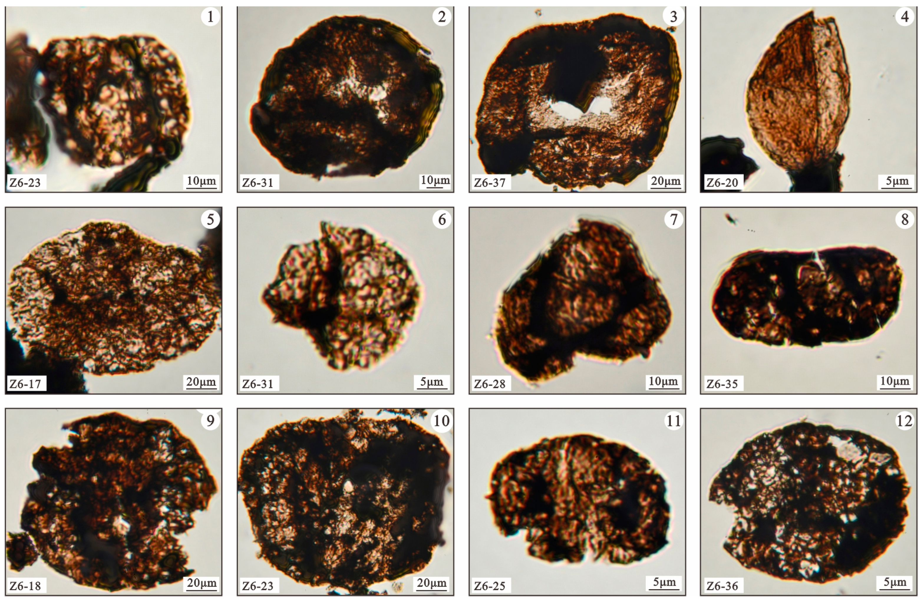
Plants produce a large number of spores or pollen that are sensitive to paleoclimate responses, and spore pollen fossils are of great significance for paleoclimate reconstruction. They can be used for paleoclimate restoration. The spore and pollen samples are all from Well Z6 in the Ordos Basin. The system collected 27 spore and pollen fossil samples from the bottom to top of the Yanghugou Formation, with a total of 32 genera of spore and pollen fossils, and the abundance and diversity of fossils in the samples are high (Figure 2 and Figure 3, and Table 4). The spore pollen assemblage is overwhelmingly dominated by fern spores, accounting for an average of 83% of the total fossil content. Next is the pollen of gymnosperms, with an average of 17%.
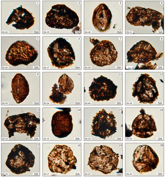
Figure 2.
Fossil spores of ferns from Well Z6 in the western margin of the Ordos Basin. ① Acanthotriletes ② Apiculatisporis ③ Cheileidonites ④ Chordasporites ⑤ Cyclogranisporites ⑥ Densosporites ⑦ Granulatisporites ⑧ Gulisporites ⑨ Laevigatosporites ⑩ Latosporites ⑪ Lophotriletes ⑫ Lycospora ⑬ Potonieisporites ⑭ Punctatosporites ⑮ Raistrickia ⑯ Reinschospora ⑰ Retusotriletes ⑱ Triquitrites ⑲ Verrucosisporites ⑳ Leiotriletes.

Figure 3.
Pollen fossils of gymnosperms from Well Z6 in the western margin of the Ordos Basin. ① Falcisporites ② Florinites ③ Crucisaccites ④ Cycadopites ⑤ Alisporites ⑥ Limitisporites ⑦ Pityosporites ⑧ Pteruchipollenites ⑨ Scheuringipollenites ⑩ Vesicaspora ⑪ Vitreisporites ⑫ Vittatina.
Table 4.
Fossil types of sporopollen assemblages from Well Z6 in the western margin of the Ordos Basin.
5. Discussion
The systematic transfer and accumulation of elements from parent rocks, influenced by erosion, transportation, and sedimentation processes, offer valuable insights into the sedimentary environment [23]. In this study, the major and trace element compositions of mudstone samples collected from the western margin of the Ordos Basin, obtained from both field profiles and drilling cores, were meticulously analyzed and tested, as indicated in Table 1 and Table 2. Based on these test and analysis results, the paper delves into the paleosalinity, oxidation–reduction conditions, and paleoclimate change characteristics of the Yanghugou Formation during its sedimentary period. By scrutinizing the variations in elemental composition, we can draw inferences about the salinity levels, redox conditions, and broader climate changes that influenced the depositional environment of the Yanghugou Formation.
5.1. Characteristics of Sedimentary Environment
5.1.1. Discrimination of Paleoclimate
(1) Indications of weathering intensity on ancient climate
The Chemical Alteration Index (CIA) serves as a tool for assessing the degree of weathering in the source area and inferring paleoclimate conditions during sedimentary processes [24]. Concurrently, the Component Variability Index (ICV) is employed to ascertain whether materials in the source region have undergone recycling [24]. The utilization of CIA and ICV values aids in evaluating the weathering intensity of the source area and, subsequently, deducing the paleoclimatic characteristics of the Yanghugou Formation during its sedimentary period [24,25,26].
The CIA can be calculated using the following formula:
CIA = 100 × Al2O3/(Al2O3 + CaO* + Na2O + K2O)
The content of each oxide in the formula is the molar fraction.
CaO* represents CaO from silicates. When the CaO value is less than the Na2O value, CaO* is the CaO value, with the reverse being the case for the Na2O value. Research has shown that the criterion for determining the CIA value is as follows: when it is less than or close to 50, it indicates that the source rock has not undergone chemical weathering. Between 50–100, it indicates that the source rock is affected by a certain degree of chemical weathering [24].
The ICV value is typically employed to analyze the compositional maturity of sedimentary rock. The tectonic background and climate environment play crucial roles in influencing the compositional maturity of sedimentary rock [24,25,26]. The ICV can be calculated using the following formula:
ICV = (Fe2O3 + K2O + Na2O + CaO + MgO + MnO + TiO2)/Al2O3
The content of each oxide in the formula is the mass fraction.
When the ICV value is less than 0.84, it suggests the presence of more clay minerals, indicating that the sediment may have undergone recycling and predominantly formed in a tectonically calm environment. Conversely, when ICV is greater than 0.84, the sediment can be considered as initially deposited in tectonically active areas [5].
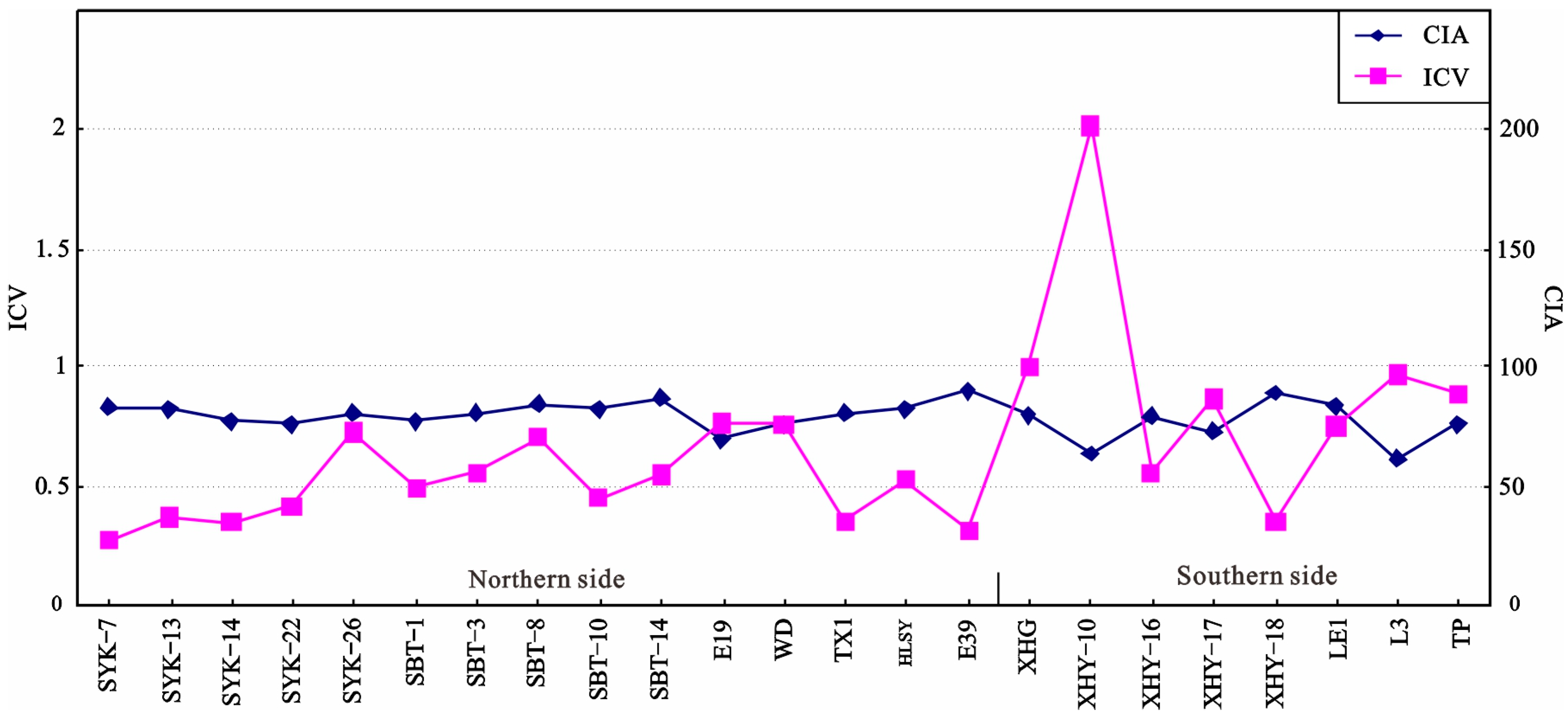
The CIA values (Table 1, Figure 4) in the northern side of the Yanghugou Formation on the western margin of the Ordos Basin range from 70.48 to 89.58, with an average of 80.84. The ICV value ranges from 0.27 to 0.77, with a mean of 0.51. On the southern side, CIA values (Table 1) range from 61.27 to 88.99, with an average of 85.83. The ICV value on the southern side ranges from 0.36 to 2.02, with a mean of 0.93. Both the northern- and southern-side CIA values indicate that the source area experienced moderate chemical weathering. However, the CIA and ICV values of the northern-side mudstone are relatively concentrated, while the changes in the CIA and ICV values of the southern-side mudstone are greater than those of the northern-side mudstone. This suggests that, during the sedimentary period of the Yanghugou Formation on the western margin of the Ordos Basin, the overall environment was mainly humid, and the source area was in a relatively stable tectonic environment. Tectonic activity in the southern side was relatively more active compared to the northern side of the western margin.
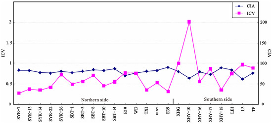
Figure 4.
Variation trend of CIA and ICV indices of Yanghugou Formation in the western margin of Ordos Basin.
(2) Geochemical criteria of paleoclimate
Sediments are influenced by the ancient sedimentary climate, and trace elements may exhibit different migration and aggregation phenomena [27]. The content ratios of Sr/Cu, Rb/Sr, and other elements are commonly used to indicate paleoclimate. According to previous research, the concentration and precipitation of lake water under marine invasion, drought, and hot climates result in an increase in Sr abundance in sediment, forming SrSO4 and precipitation. Under warm and humid climate conditions, the abundance of Sr will decrease [22]. Cu is often used as an effective measure of organic matter flux in sediments [28]. The Sr content and Sr/Cu content ratio are ideal indicators to reflect climate. According to the discriminant index of thee Sr/Cu value, if it is greater than 10, it indicates a dry and hot climate, and, if it is between 1–10, it indicates a warm and humid climate [1,28]. The Sr/Cu values of the samples from the Yanghugou Formation in the study area range from 1.59 to 16.13, with a mean of 5.51. The average value of the northern samples is 5.56, slightly higher than the average value of 5.46 in the southern margin. Most samples have a ratio of less than 10, and some samples have values greater than 10, indicating that their sedimentary environment was mainly warm and humid.
Given that Rb is a dispersed element in sediments, it is often present in minerals containing K and retained in place [29], less affected by weathering. However, the behavior of Sr and Rb is quite different, and Sr will be lost to varying degrees with the strength of weathering [30]. The Rb/Sr content ratio is influenced by the ancient climate, with high Rb/Sr values in warm and humid environments and low Rb/Sr values in arid environments [29,30]. The Rb/Sr values of the Yanghugou Formation in the study area range from 0.53 to 1.62, with an average of 0.86. The northern-side sample has an average of 0.94, and the southern-side sample has an average of 0.78 (Table 2). The northern samples have higher Rb/Sr ratios, indicating they have formed in a relatively warm and humid environment.
(3) Indications of palynological assemblages on paleoclimate
The study of spore pollen fossils holds great significance for the restoration of ancient vegetation, the reconstruction of ancient climate, and the determination of stratigraphic age [31]. Spore pollen fossils can be utilized for precise stratigraphic division and paleoclimate restoration. The growth of plants is intricately linked to the environment, with climate characteristics playing a decisive role in the types of plants present in a region. Changes in climate can stimulate variations in plant species or communities, and alterations in plant genera can serve as indicators of climate evolution to a certain extent [31]. Due to the adaptability of spore pollen parent plants to temperature, humidity, and dryness, the climate and changes during a specific period can be inferred by examining the association between spore pollen assemblages and plant communities with the natural environment. This approach helps elucidate vegetation zoning in various geological historical periods and provides insights into the climate’s dryness, wetness, and warmth in a particular area.
The characteristics of spore pollen assemblages in Well Z6 suggest that the plants in this area belong to the Huaxia plant geographical area [32]. Fern plants, represented in spore pollen assemblages, have specific requirements for their growth environment, making them excellent indicators for climate and ecology. In contemporary settings, ferns are primarily distributed in tropical and subtropical regions, favoring forest and swamp environments. These plants thrive in warm and humid conditions. Consequently, it can be inferred that, during the sedimentation of the Yanghugou Formation in the western margin of the Ordos Basin, the climate belonged to a warm and humid tropical–subtropical climate.
5.1.2. Discrimination of Paleosalinity
The paleosalinity of water bodies is commonly determined using trace element content and ratios [33,34,35]. In this article, Sr/Ba and Th/U element ratios are employed to differentiate the paleosalinity of water bodies during the sedimentary period of the Yanghugou Formation.
Both Sr and Ba elements are widely distributed in the Earth’s crust [36,37,38]. As water salinity increases, Ba tends to precipitate in the form of BaSO4, leading to a positive correlation between the Sr/Ba content ratio and salinity. Sr/Ba values greater than 0.6 are considered indicative of marine brackish water, values between 0.3 and 0.6 suggest transitional brackish water, and values less than 0.3 indicate continental freshwater [39]. The Sr/Ba values in the Yanghugou Formation samples from the study area range from 1.11 to 0.1, with an average of 0.37, suggesting that the water body during the sedimentary period was in a brackish transitional environment.
In the process of weathering, the Th element is easily absorbed by clay minerals and retained, while the U element is lost or exists in the form of oxides during weathering. The content ratio of these two elements can be used as a distinguishing marker for paleosalinity [1,40]. Generally, a Th/U ratio less than 2 indicates a marine environment, 2–7 suggests a transitional semi-saline water environment, and a ratio greater than 7 signifies a terrestrial freshwater environment [1,38]. The test results of Yanghugou Formation samples in the research area (Table 2) show that the Th/U values range from 1.14 to 4.4, with an average value of 2.8. The average value for the northern-side samples is 2.83, and, for the southern samples, it is 2.76. This indicates that the water body during the sedimentary period was in a brackish transitional environment.
The above research demonstrates that the paleosalinity of the waters in the southern side of the study area is higher than that of the northern side. This is inferred to be due to the influence of the northern mountainous belt, such as Qianli Mountain–WuDa–Shizuishan, which led to the deposition of a horn-shaped estuary bay during its southward extension process. At the same time, the low salinity in the northern side could be attributed to the influence of continental freshwater injection in the northern-side orogenic belt.
5.1.3. Identification of Paleoredox Environment
The geochemical properties of U and V elements are similar, as they are more easily dissolved in an oxidizing environment and enriched in authigenic minerals in an anoxic environment [41]. The V element in water is more likely to precipitate in the form of organic complexes than the Ni element in a reducing environment, making it a useful indicator of the reducing environment. The V/(V + Ni) value, used in the literature, serves as a different redox indicator of the water body compared to δU [42,43,44,45].
In reducing conditions, V is easily adsorbed by colloidal particles and precipitates, while Ni is easily enriched. Therefore, the oxidation–reduction environment of sedimentary water is analyzed by the V/(V + Ni) content ratio [46,47]. When the V/(V + Ni) value is greater than 0.84, it indicates a reducing environment; between 0.60 and 0.84, it indicates a weak oxidation–reduction environment, and less than 0.6 indicates an oxygen-enriched environment [40]. The distribution of V/(V+Ni) values in the study area ranges from 0.59 to 1.0, with an average of 0.8, indicating that the sedimentary environment of the Yanghugou Formation is a weak oxidation–reduction environment.
Radioactive elements such as U and Th are often enriched in argillaceous rocks. The Th element is easily absorbed by clay minerals and retained, while the U element will be lost or exist in the form of oxides during weathering. Therefore, the δU method can be used to determine the oxidation–reduction property of the paleoenvironment. The δU can be calculated using the following formula:
where δU = 1 is the critical point, δU < 1 is the normal water environment, and δU > 1 is the anoxic reduction environment [5]. The δU values of the Yanghugou Formation in the study area range from 0.76 to 1.43, with an average value of 1.06. The δU values in the southern side and the northern side have little change compared with each other. A comprehensive analysis shows that it is a weak oxidation–reduction transition environment.
δU = U/[0.5 × (Th/3 + U)]
5.2. Tectonic Indication
5.2.1. Tectonic Background Discrimination of Major Elements
Based on the test results of principal elements in the mudstone of the Yanghugou Formation in the western margin of the Ordos Basin (Table 3), combined with the element tectonic background diagram established by predecessors [48], the tectonic background properties of the provenological area can be preliminarily inferred.
The relationship between the content of Fe2O3 + MgO and the ratio of the content of K2O/Na2O and Al2O3/(CaO + Na2O) in major elements, and their characteristics have significant differences in tectonic background [49,50]. The mass fraction of Fe2O3 + MgO in the mudstone of the Yanghugou Formation ranges from 0.7% to 9.49%, with an average of 5.28%. The K2O/Na2O ratio ranges from 2.68 to 28.60, with an average of 14.68. The Al2O3/(CaO + Na2O) ratio ranges from 2.94 to 69.18, with an average of 22.51. The high ratio, indicating richness in Al2O3, K2O, and Na2O, is similar to the tectonic background of the continental margin type.
5.2.2. Tectonic Background Discrimination of Trace and Rare Earth Elements
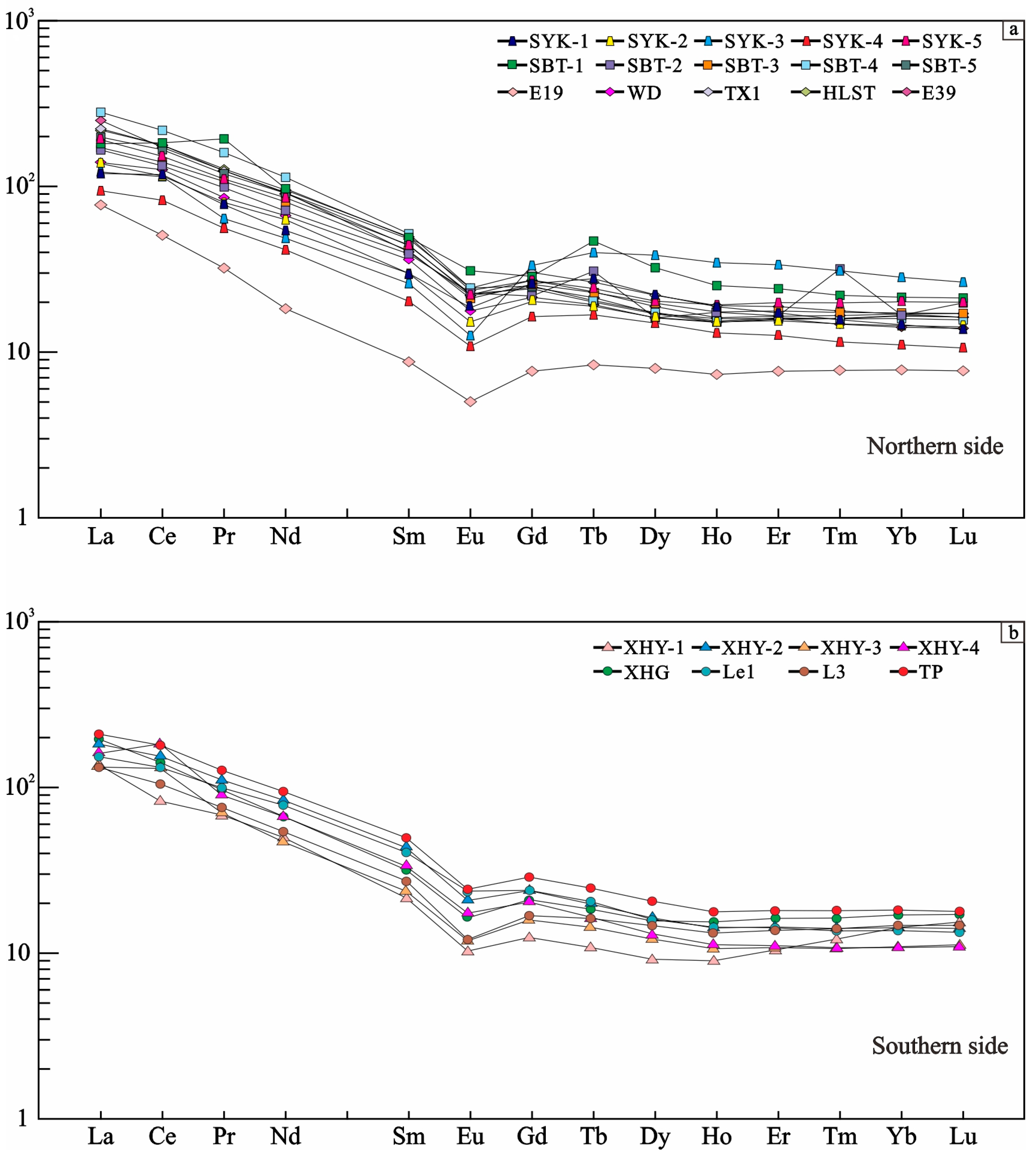
The REE analysis results and partitioning patterns of mudstone samples from the Yanghugou Formation in this area are shown in Table 3 and Figure 5. The total mass fraction of rare earth elements in the northern-side rare earth element (ΣREE) is in the range of (91.34~788.04) × 10−6, with a concentration between (206.08–385.25) × 10−6. The southern ΣREE ranges from (165.74~319.19) × 10−6, indicating a relative enrichment of rare earth elements in the Yanghugou Formation (Figure 5a). The mass fractions of ΣLREE in the northern side and southern side are (82.1~745.13) × 10−6 and (152.42~294.0) ×10 −6, respectively. The mass fractions of ΣHREE are (9.24~42.91) × 10−6 and (13.32~25.19) × 10−6, respectively. The values of ΣLREE/ΣHREE in the northern side and southern side range from 4.31 to 17.36 (mean 10.85) and 9.86 to 15.75 (mean 12.11), respectively (Figure 5b). The values of (La/Yb)N (chondrite) are concentrated in 1.14~1.84 (mean 1.42) and 1.26~1.8 (mean 1.56). All samples exhibit relatively flat heavy REEs (HREEs) in the chondrite-normalized REE patterns and a weakly negative Eu anomaly.
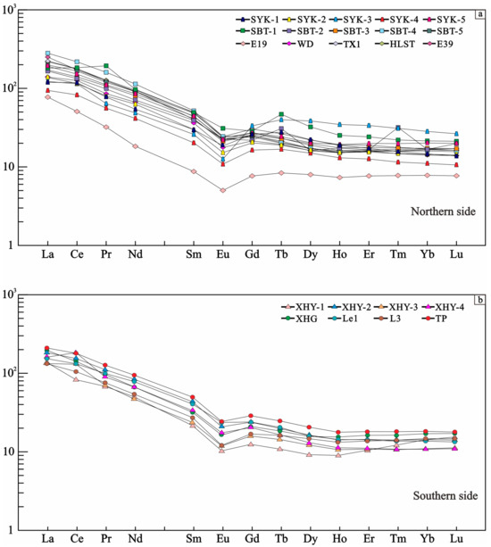
Figure 5.
Chondrite-normalized REE patterns in the northern-side and southern-side Yanghugou Formation in the western margin of Ordos Basin.
As observed in the partition pattern of rare earth elements, there is a “gentle right dip” in the partition curve from the northern side to the southern side of the study area, and the distribution pattern of heavy rare earth elements is “flat”. The Ce anomaly is not prominent, and the Eu deficit is evident (δEu = 0.34~0.83, average value 0.67).
Referring to the characteristics and model curve features of rare earth elements under different tectonic backgrounds as summarized by M.R. Bhatia [48], the characteristic parameters of rare earth elements were comprehensively and comparatively analyzed. It is suggested that the rare earth element characteristic values of the Yanghugou Formation exhibit high ΣREE and LREE enrichment, as well as a noticeable negative Eu anomaly, which is closest to the characteristic values in a continental-margin-type background. The ancestral source is believed to be from the basement of the upper uplift and the internal tectonic highland of the craton. The distribution and distribution characteristics of rare earth elements in mudstone are also consistent with this interpretation.
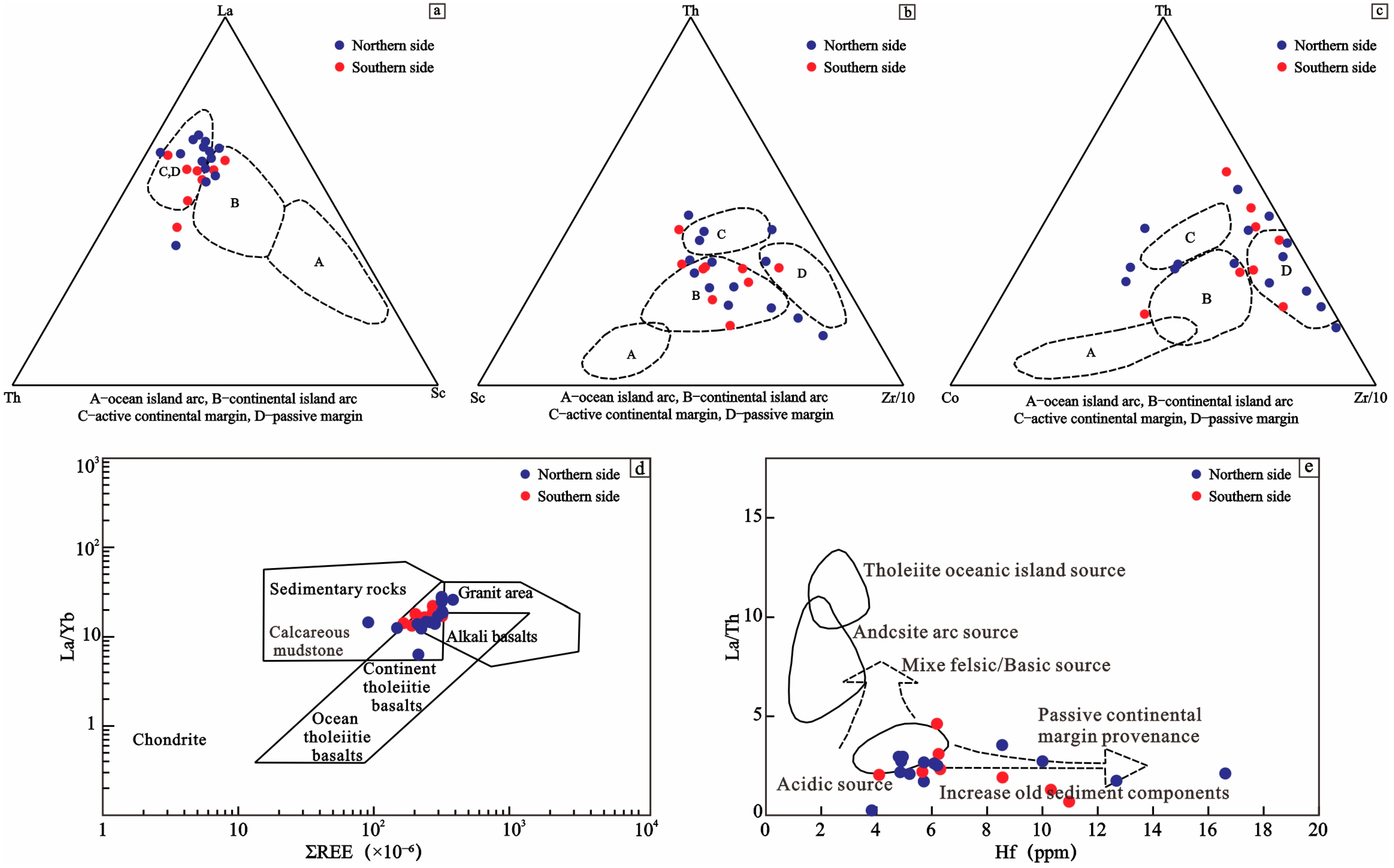
Trace elements are highly stable and can be used to trace the tectonic environment of sediments. For instance, the (La/Yb)-REE diagram can be employed to analyze the origin of rock groups in the source region [46]. Diagrams such as La-Th-Sc, Th-Sc-Zr, Th-Co-Zr, and (La/Th)-Hf can be used to distinguish the tectonic environment of the source area (Figure 6) [48].
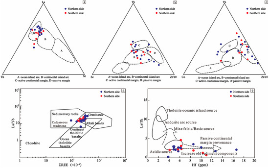
Figure 6.
Discrimination diagram of mudstone tectonic setting in the northern side and southern side of Yanghugou Formation in the western margin of Ordos Basin.
According to the La-Th-Sc identification diagram, most data points of the provenance in the southern side and northern side of the study area are distributed in the passive continental margin and active continental margin. A few data points fall in the range of the continental island arc, indicating that the provenance area belongs to the tectonic property of a continental margin type for a long time, followed by the continental island arc [49,50].
From the Th-Sc-Zr and Th-Co-Zr discrimination diagrams, the southern side is mainly distributed in the continental arc and passive continental margin, while the northern side is distributed in the active continental margin besides the continental arc and passive continental margin. The northern side is characterized by a passive continental margin and active continental margin, while the southern side is characterized by a passive continental margin and continental arc.
By comparing the characteristics of source rocks with the (La/Yb)-REE discriminant diagram, it is found that the southern-side and northern-side source rocks mainly belong to the overlapping area of sedimentary rocks, granite, and alkaline basalt rocks. A small amount of source rocks is distributed in granite or sedimentary rocks, indicating that there is little difference between the southern-side and northern-side source rocks of the Yanghugou Formation. Both are from the upper crust, and their compositions are mainly influenced by felsitic source areas. A small amount of source rocks consists of alkaline basalt and granite. Additionally, through the analysis of chondrite rare earth partition models of samples, it is found that the samples from the southern side and the northern side show LREE enrichment and HREE depletion. The change trend is relatively gentle, and the negative anomaly characteristics of Eu elements can be clearly seen, indicating that the source rocks are similar to the felsitic composition of the upper crust.
According to the (La/Th)-Hf source rock discrimination diagram, the northern-side and southern-side provenance mainly belong to the upper-crust felsic provenance and passive continental provenance. This indicates that the source rocks are mainly influenced by the upper-crust felsic provenance. There are several sites in the southern side near the mixing area of felsic and mafic rocks, indicating that there are fewer mafic magmatic rocks in the parent rocks of the provenance area in the southern side [49,50].
According to the above discrimination diagram of trace element source rocks, the source rocks of Yanghugou Formation in the study area are mainly felsic rocks in the upper crust, accompanied by a small amount of meso-basic magmatic rocks and ancient sediments of sedimentary recirculation [49,50]. In addition, the REE chemical characteristics of the study area show a large LREE/HREE value, indicating that the degree of fractionation is obvious, and LREE is relatively enriched compared to HREE. The REE partition pattern shows a “right-leaning” curve of the Eu negative anomaly, indicating that the source rocks of Yanghugou Formation in the study area are mainly from the continental upper-crust rocks.
5.2.3. Tectonic Indication
The western margin of the Ordos Basin is positioned at the convergence of the North China Craton, Qilian orogenic belt, and Alxa block, making it a geotectonically unique area. During the Late Paleozoic, the Siberian block in the northern margin underwent subduction towards the North China block, leading to the gradual closure of the Paleo-Asian Ocean from west to east. The Alxa block, characterized by the tectonic background of oceanic crust subduction, contributed active continental margin sedimentary materials to the northern side throughout the late Paleozoic.
The southern side of the study area experienced the expansion of the Mianluo Ocean, allowing both the southern Qinling and the southern margin of the North China block to supply recirculated sediments from a passive continental margin environment. The Early Paleozoic craton of the North Qilian orogenic belt underwent fragmentation, forming an aulacogen. Towards the end of the Early Paleozoic, the aulacogen closed, leading to mountain formation during the Qilian Event. In the late Paleozoic, the Qilian–North Qinling orogenic belt exhibited stable tectonic activity, contributing to the provenance of the southern side.
The tectonic background of the study area’s source region is shaped by the Alxa block on the active continental margin and the Qilian–North Qinling orogenic belt on the passive continental margin. The study area exists in a tectonic setting characterized by north–south compression, a rift in the western margin, uplift in the south and north, rapid subsidence in the west, and the manifestation of a marginal rift basin on the western margin of the basin.
6. Conclusions
(1) The paleosedimentary environment of the Yanghugou Formation in the western margin of the Ordos Basin is characterized by a warm and humid climate, and the water body reflects a weak oxidation–reduction brackish water environment. The tectonic conditions in the source area are relatively stable, and the source rock exhibits a moderate degree of weathering.
(2) The sediment source for the Yanghugou Formation primarily originates from the felsitic source area of the upper crust. This suggests that, during the sedimentary period of the Yanghugou Formation, the western margin of the basin displayed characteristics of a marginal rift basin.
(3) The northern side of the Yanghugou Formation in the Ordos Basin is influenced by the active continental margin of the Alxa block, while the southern side is associated with the continental marginal tectonic setting dominated by the passive continental margin of the Qinling–Qilian Orogenic belt.
Author Contributions
Conceptualization W.Y., F.W. and L.G.; formal analysis W.Y.; investigation W.Y.; writing—original draft W.Y.; Supervision F.W. and L.G.; funding acquisition F.W. and L.G.; writing—review and editing J.H.; Picture, and English writing Z.M. and J.W. (Ji Wang); Picture, and editing J.W. (Jingyi Wu) and Y.X. All authors have read and agreed to the published version of the manuscript.
Funding
This paper is supported by the major science and technology project of petrochina Changqing Oilfield Company, “Comprehensive Interpretation and Basic Geological Research of Ordos Basin Seismic Framework and Large Section” (2023DZZ02) and (No. CQYT-CQKTY-2020-JS-51586) and Ministry of Science and Technology of the People’s Republic of China, Grant Number: 2016ZX0504605-001.
Data Availability Statement
All data generated or analyzed during this study are included in this published article.
Acknowledgments
The authors thank the editors and anonymous referees for their helpful comments. Thanks are also given for the approval of core samples from PetroChina Changqing Oilfield Company.
Conflicts of Interest
The authors declare that they have no known competing financial interests or personal relationships that could have appeared to influence the work reported in this paper.
References
- Fu, J.H.; Li, S.X.; Xu, L.M.; Niu, X.B. Paleo-sedimentary environmental restoration and its significance of Chang 7 Member of Triassic Yanchang Formation in Ordos Basin, NW China. Petrol. Explor. Dev. 2018, 45, 936–946. [Google Scholar] [CrossRef]
- Rimmer, S.; Thompson, J.; Goodnight, S.; Robl, T. Multiple controls on the preservation of organic matter in Devonian–Mississippian marine black shales: Geochemical and petrographic evidence. Palaeogeogr. Palaeoclimatol. Palaeoecol. 2004, 215, 125–154. [Google Scholar] [CrossRef]
- Shi, J.; Huang, W.H.; Lü, C.H.; Cui, X.N. Geochemical characteristics and geological significance of the Upper Paleozoic mudstones from Linxing area in Ordos Basin. Acta Petrol. Sin. 2018, 39, 876–889. [Google Scholar]
- Tian, J.C.; Chen, G.W.; Zhang, X.; Nie, Y.S.; Zhao, Q.; Wei, X.D. Application of sedimentary geochemistry in the analysis of sequence stratigraphy. J. Chengdu Univ. Technol. Sci. Technol. Ed. 2006, 33, 30–35. [Google Scholar]
- Wang, F.; Chen, R.; Liang, Q.S.; Chang, X.L.; Tian, J.C.; Deng, X.Q. Geochemical characteristics and depositional environments of mudstones from the Triassic Zhifang Formation in the Tongchuan Area, southern Ordos Basin, China. Geol. J. 2020, 55, 3857–3869. [Google Scholar] [CrossRef]
- Wu, Z.P.; Hou, X.B.; Li, W. Discussion on mesozoic basin patterns and evolution in the eastern north China block. Geotecton. Metallog. 2007, 31, 385–399. [Google Scholar]
- Xia, Y.P.; Xu, L.G.; Zheng, L.H.; Liu, W.H.; Lu, Y.S. Structural features and oil-gas prospecting targets of thrusting fault belt in western margin of Ordos Basin. China Pet. Explor. 2005, 10, 13–19. [Google Scholar]
- Liu, Y.M.; Kong, Z.P. Prospect of oil and gas of thrust belt in western margin in Ordos Basin. Petrol. Explor. Dev. 1984, 11, 33–40. [Google Scholar]
- Yan, W.H. Sedimentary System and Sequence Stratigraphy of Upper Paleozoic in Northwest Ordos Basin. Ph.D. Thesis, Northwestern University, Xi’an, China, 2002. [Google Scholar]
- Zhang, G.S.; Zhang, J.; Wang, X.; Liu, B.X.; Guo, Y.H. Late Paleozoic sequence stratigraphic division of the western fringe of e’erduosi basin. Nat. Gas Ind. 2005, 25, 19–22. [Google Scholar]
- Guo, Y.Q.; Wang, M.X.; Guo, B.C.; Cai, Z.C.; Hui, L.; He, Z.Q.; Ma, Y.; Li, W.H.; Li, B.Q. Sedimentary system characteristics and paleographic evolution of Upper Paleozoic of northern west margin, Ordos Basin. J. Northwest Univ. (Nat. Sci. Ed.) 2020, 50, 93–104. [Google Scholar]
- Wang, L. Study on Depositional System of Permian Taiyuan and Shanxi formations in the Western Margin of Ordos Basin. Ph.D. Thesis, Northwestern University, Xi’an, China, 2005. [Google Scholar]
- Sun, Y.S.; Zhao, Z.Y.; Guo, Y.R.; Zhang, Y.L.; Wang, Y. Analyses of the sedimentary environments and reservoir characteristics for West Margin of Ordos Basin. Pet. Geol. Oilfield Dev. Daqing 2015, 34, 34–38. [Google Scholar]
- Gao, X.Y. Petrological Characteristics of Upper Paleozoic Reservoir in Huitan 1 Well, Western Ordos Basin. Ph.D. Thesis, Chengdu University of Technology, Chengdu, China, 2008. [Google Scholar]
- Li, J.F.; Sun, L.; Ma, J.; Zan, C.L. Geochemical characteristics of Upper Paleozoic natural gas accumulation in napped belt, Western Margin of Ordos Basin. Nat. Gas Geosci. 2007, 18, 436–439. [Google Scholar]
- Song, B.B. Petrological Characteristics and Diagenesis of Upper Paleozoic Reservoir in the Western Margin of Ordos Basin. Ph.D. Thesis, China University of Geosciences (Beijing), Beijing, China, 2007. [Google Scholar]
- Wang, Z.T.; Wang, K.L.; Wang, F.; Kong, L.; Tian, J.C.; Fu, X.X. Provenance Analysis of Yanghugou Formation in the Western Margin of Ordos Basin, China. J. Earth Sci. Environ. 2019, 41, 281–296. [Google Scholar]
- Zhao, P.K.; Ji, Y.L. Sedimentary facies on the Upper Paleozoic of the oreland basin of the western margin of the Ordos. Xinjiang Geol. 2005, 23, 152–157. [Google Scholar]
- Yuan, X.Q.; Geng, G.C. Preliminary understanding of Carboniferous paleoecology, paleogeography and Paleoclimate in the western margin of Ordos Basin. J. Stratigr. 1987, 11, 180–186. [Google Scholar]
- Wei, H.H. Sedimentary System and Sequence Stratigraphy of Carboniferous Permian in Ordos Area. Ph.D. Thesis, Northwestern University, Xi’an, China, 2002. [Google Scholar]
- Wei, P.S.; Li, T.S.; Li, A.C.; Wang, J.G. Carboniferous Sedimentary Evolution and Reservoir Estimation in Bayanhot Basin. Acta Sedimentol. Sin. 2005, 31, 240–247. [Google Scholar]
- Wang, F.; Liu, X.C.; Deng, X.Q.; Li, Y.H.; Tian, J.C.; Li, S.X.; You, J.Q. Geochemical characteristics and environmental implications of trace elements of Zhifang Formation in Ordos Basin. Acta Sedimentol. Sin. 2017, 35, 1265–1273. [Google Scholar]
- Lei, K.Y.; Zhang, C.Y.; Zhang, L.; Wu, B.L.; Cun, X.N.; Sun, L. Element geochemical characteristics of the Jurassic mudstones in the Northern Ordos Basin: Implications for tracing sediment sources and paleo-environment restoration. Acta Sedimentol. Sin. 2017, 35, 621–636. [Google Scholar]
- Nesbitt, H.W.; Young, G.M. Early Proterozoic climates and plate motions inferred from major element chemistry of lutites. Nature 1982, 299, 715–717. [Google Scholar] [CrossRef]
- Zhang, T.F.; Sun, L.X.; Zhang, Y.; Cheng, Y.H.; Li, Y.F.; Ma, H.L.; Lu, C.; Yang, C.; Guo, G.W. Geochemical characteristics of the Jurassic Yan’an and Zhiluo Formations in the northern margin of Ordos Basin and their paleoenvironmental implications. Acta Geol. Sin. 2016, 90, 3454–3472. [Google Scholar]
- Tribovillard, N.; Algeo, T.J.; Lyons, T. Trace metals as paleoredox and paleoproductivity proxies: An update. Chem. Geol. 2006, 232, 12–32. [Google Scholar] [CrossRef]
- Xu, Z.H.; Hu, S.Y.; Wang, Z.C.; Xu, A.N.; Jiang, Q.C. Restoration of Paleoclimate and Its Geological Significance: As an Example from Upper Triassic Xujiahe Formation in Sichuan Basin. Acta Sedimentol. Sin. 2011, 29, 235–244. [Google Scholar]
- Chen, J.; Wang, Y.J.; Chen, Y.; Liu, L.W.; Ji, J.F.; Lu, H.Y. Rb and Sr geochemical characterization of the Chinese loess and its implications for palaeomonsoon climate. Acta Geol. Sin. 2001, 75, 259–266. [Google Scholar]
- Rónald Cox Lowe, D.R.; Cullers, R.L. The influence of sediment recycling and basement composition on evolution of mudrock chemistry in the southwestern United States. Geochim. Cosmochim. Acta 1995, 59, 2919–2940. [Google Scholar]
- Liang, B.; Wang, Q.W.; Kan, Z.Z. Geochemistry of eary Jurassic mudrocks from Ziliujing Formation and implications for source-area and weathering in dinosaur fossils site in GongXian, Sichuang Province. J. Mineral. Petrol. 2006, 26, 94–99. [Google Scholar]
- Luengo, M.S.; Vilanova, I.; Pisano, M.F.; D’Amico, G.; Pommarés, N.; Fucks, E. Salt marsh palynological assemblages as modern analogue tools for interpreting past vegetation zones and environmental conditions in the NE coastal plain of Argentina. J. S. Am. Earth Sci. 2021, 106, 103025. [Google Scholar] [CrossRef]
- Yao, J.X.; Xiao, X.C.; Gao, L.D.; Wang, N.W.; Ji, W.H.; Wang, S.Y.; Wang, Y.; Chi, Z.Q. Discovery and geological significance of the Permian sporopollen fossils from Daftar, Taxkorgan, Xinjiang. J. Paleogeogr. 2005, 321–326. [Google Scholar]
- Tian, J.C.; Zhang, X. Sedimentary Geochemistry; Geological Publishing House: Beijing, China, 2016; pp. 66–77. [Google Scholar]
- Li, X.F.; Gang, W.Z.; Yao, J.L.; Gao, G.; Wang, C.C.; Li, J.Y.; Liu, Y.; Guo, Y.; Yang, S.R. Major and trace elements as indicators for organic matter enrichment of marine carbonate rocks: A case study of Ordovician subsalt marine formations in the central-eastern Ordos Basin, North China. Mar. Pet. Geol. 2020, 111, 461–475. [Google Scholar] [CrossRef]
- Deng, H.W.; Qian, K. Sedimentary Geochemistry and Environment Analysis; Gansu Science and Technology Press: Lanzhou, China, 1993; pp. 95–104. [Google Scholar]
- Wen, H.G.; Zheng, R.C.; Tang, F.; Zheng, A.P.; Sang, T.Y.; Chen, S.C.; Li, G.L.; Li, L.X. Reconstruction and analysts of palaeosalinity and paleoenvironment of the Chang6 Member in the Gengwan region, Ordos basin. J. Miner. Pet. 2008, 28, 114–120. [Google Scholar]
- Wang, M.F.; Jiao, Y.Q.; Wang, Z.H.; Yang, Q.; Yang, S.K. Recovery paleosalinity in sedimentary environment: An example of mudstone in Shuixigou Group, southwestern margin of Tur-pan-Hami basin. Xinjiang Pet. Geol. 2005, 26, 419–422. [Google Scholar]
- Xu, J.; Pu, R.H.; Yang, L.; Li, A.H. The Palaeosalinity Analysis of Carboniferous Mudstone, Tarim Basin. Acta Sedimentol. Sin. 2010, 28, 509–517. [Google Scholar]
- Qian, L.J.; Chen, H.D.; Lin, L.B.; Xu, S.L.; Ou, L.H. Geochemical Characteristics and Environmental Implications of Middle Jurassic Shaximiao Formation, Western Margin of Sichuan Basin. Acta Sedimentol. Sin. 2012, 30, 1061–1071. [Google Scholar]
- Zhang, W.Z.; Yang, H.; Yang, Y.H.; Kong, Q.F.; Wu, K. Petrology and element geochemistry and development environment of Yanchang Formation Chang-7 high quality source rocks in Ordos Basin. Geochimica 2008, 37, 59–64. [Google Scholar]
- Xie, G.L.; Shen, Y.L.; Liu, S.G.; Hao, W.D. Trace and rare earth element (REE) characteristics of mudstones from Eocene Pinghu Formation and Oligocene Huagang Formation in Xihu Sag, East China Sea Basin: Implications for provenance, depositional conditions and paleoclimate. Mar. Pet. Geol. 2018, 92, 20–36. [Google Scholar] [CrossRef]
- Wignall, P.B.; Twitchett, R.J. Oceanic anoxia and the end Permian mass extinction. Science 1996, 272, 1155–1158. [Google Scholar] [CrossRef]
- Kimura, H.; Watanabe, Y. Ocean anoxia at the Precambrian—Cambrian boundary. Geology 2001, 29, 995–998. [Google Scholar] [CrossRef]
- Jones, B.J.; Manning, A.C. Comparison of geochemical indices used for the interpretation of palaeoredox conditions in ancient mudstone. Palaeogeogr. Palaeoclimatol. Palaeoecol. 1994, 111, 111–129. [Google Scholar] [CrossRef]
- Liu, A.; Li, X.B.; Wang, C.S.; Wei, K.; Wang, B.Z. Analysis of Geochemical Feature and Sediment Environment for Hydrocarbon Source Rocks of Cambrian in West Hunan-Hubei Area. Acta Sedimentol. Sin. 2013, 31, 1122–1132. [Google Scholar]
- Zhao, C.L.; Zhu, X.M. Sedimentary Petrology; Petroleum Industry Press: Beijing, China, 2001. [Google Scholar]
- Li, G.Z.; Hu, B.; Deng, T.L.; Yuan, Z.Y. Petroleum geological significance of microelements V and Ni. Nat. Gas Geosci. 2008, 19, 13–17. [Google Scholar]
- Bhatia, M.R. Plate tectonics and geochemical composition of sandstone. J. Geol. 1983, 91, 611–627. [Google Scholar] [CrossRef]
- Li, T.B.; Zhang, X.W.; Wang, C.; Wang, R.L. Reconstruction of Protoliths of Metamorphic Rocks and Tectonic Setting of the Haiyuan Group in the Eastern Segment of the North Qilian Mountains, China. Geol. Bull. China 2006, 25, 194–203. [Google Scholar]
- Taylor, S.R.; McLennan, S.M. The Continental Crust: Its composition and evolution. J. Geol. 1985, 94, 57–72. [Google Scholar]

Disclaimer/Publisher’s Note: The statements, opinions and data contained in all publications are solely those of the individual author(s) and contributor(s) and not of MDPI and/or the editor(s). MDPI and/or the editor(s) disclaim responsibility for any injury to people or property resulting from any ideas, methods, instructions or products referred to in the content. |
© 2023 by the authors. Licensee MDPI, Basel, Switzerland. This article is an open access article distributed under the terms and conditions of the Creative Commons Attribution (CC BY) license (https://creativecommons.org/licenses/by/4.0/).