Article

Tectonic–Climate Interactions Controlled the Episodic Magmatism and Exhumation of the Zheduo–Gongga Massif in the Eastern Tibetan Plateau

1
Key Laboratory of Marine Mineral Resources, Ministry of Natural Resources, Guangzhou Marine Geological Survey, China Geological Survey, Guangzhou 511458, China
2
Southern Marine Science and Engineering Guangdong Laboratory (Guangzhou), Guangzhou 511458, China
3
State Key Laboratory for Mineral Deposits Research, School of Earth Science and Engineering, Nanjing University, Nanjing 210023, China
4
Guangdong Provincial Key Lab of Geodynamics and Geohazards, School of Earth Sciences and Engineering, Sun Yat-sen University, Zhuhai 519080, China
5
Southern Marine Science and Engineering Guangdong Laboratory (Zhuhai), Zhuhai 519080, China
6
Institute of Geology, Chinese Academy of Geological Sciences, Beijing 100037, China
*
Author to whom correspondence should be addressed.
Minerals 2024, 14(11), 1108; https://doi.org/10.3390/min14111108
Submission received: 12 August 2024 / Revised: 8 October 2024 / Accepted: 21 October 2024 / Published: 30 October 2024
(This article belongs to the Special Issue Low-Temperature Thermochronology and Its Applications to Tectonics)

Abstract

:
The Zheduo–Gongga Mountain, an enormous tower located at the boundary of the eastern Tibetan Plateau, is an ideal place to study the contribution of the climate and/or tectonics to the mountain building. Here, we report new zircon U–Pb ages, biotite 40Ar–39Ar, and apatite fission track (AFT) ages of granites along the Zhonggu transect in the northern part of the Zheduo–Gongga massif to investigate the detailed exhumation history and mechanism. The results show zircon U-Pb ages of 14.3 ± 0.3 and 11.3 ± 0.2 Ma, Biotite 40Ar–39Ar ages of 4.39 ± 0.07 and 3.62 ± 0.05 Ma, and AFT ages of ~2.6–0.9 Ma. Combining previous structural and geochronological studies, we argue that the growth and exhumation of the Zheduo–Gongga Mountain experienced the following stages. Late Oligocene–early Miocene crust shortening and magmatism marked the initiation of the crustal thickening and surface uplift during ~32–11 Ma, forming a migmatite–granitic belt along the Xianhuihe fault, in response to the northward advancing of the Indian plate into the Eurasian plates. Subsequently, the massif experienced episodic phases of exhumation with variable rates. The exhumation occurred at a rate of ~1–1.5 km/Ma with a cooling rate of 70 ± 20 °C/m.y. during ~11–5 Ma coinciding with the coeval intensification of the Asian monsoon and clockwise rotation of the Chuandian block, south of the Xianshuihe fault. During ~5–2 Ma, a phase of accelerated exhumation (~2–5 km/Ma) started, followed by a possible phase of decelerated exhumation (~1–1.5 km/Ma, corresponding to a cooling rate of 120 ± 20 °C/m.y.) since ~2 Ma, when alpine glaciations initiated due to global cooling. This study highlights the importance of tectonic deformation during ~11–5 Ma in controlling the early growth and exhumation of high mountains in the eastern Tibetan Plateau. The climate may account for the later exhumation of the Zheduo–Gongga mountain since ~5 Ma.

1. Introduction

The highest Tibetan Plateau, regarded as the Third Pole of the Earth and created by the indentation of India into Asia, is an ideal area to test the different models of plateau evolution, e.g., lower crust channel flow [1,2,3,4,5,6,7,8,9], crust shortening [8,9,10,11,12,13,14], and climate–tectonic interaction [15,16,17,18]. One of the most debated aspects in these models is the connection between climate-driven erosion and lithospheric tectonics during mountain evolution. Interactive climate–tectonic models are in agreement with analog experiments, numerical experiments, and basic physical arguments [15,16,19,20,21,22,23]. However, limited studies constrain the contribution of the climate–tectonic interaction to the extremely high mountain exhumation, such as the Himalaya [15,16,20,23,24]. Nevertheless, except for the Himalaya, the Zheduo–Gongga Mountain, an enormous tower with a summit of 7556 m, located at the climate boundary of the eastern Tibetan Plateau, is another ideal place to study the interactions (Figure 1).
Within the Zheduo–Gongga Mountain and adjacent regions, numerous studies of different disciplines have been performed. These studies published abundant data from different disciplines, including multi-thermochronological data [12,25,26,27,28,29,30,31,32,33,34,35], erosion rates of different time scales [36,37,38], fault slip rates [39,40], Asian monsoon evolution [20,41,42,43,44], and geophysical structures [5,45,46]. These multi-disciplinary studies have provided a wealth of data that may help us to understand the climate–tectonic interactions and the exhumation of enormous mountains in the eastern Tibetan Plateau.
In the current study, we offer new zircon U–Pb analyses, biotite 40Ar–39Ar, and apatite fission track (AFT) data (<5 Ma) of the Zheduo–Gongga range (Figure 1b), aiming to constrain its detailed cooling and exhumation history. Combining these new data with previous results, we attempt to link the exhumation of Zheduo–Gongga mountain with the activity of the Xianshuihe fault and climate change to test feedback mechanisms between tectonic and climate-driven erosion of the Zheduo–Gongga mountain during the late Cenozoic.
Figure 1. (a) Tectonic framework of the Tibetan Plateau. The black open rectangle indicates the location of (b). TRMB—Tarim block; NCB—North China block; YB—Yangtze block; ICB—Indo-China block; QDM—Qaidam terrane; SGT—Songpan–Ganze terrane; QT—Qiangtang terrane; LS—Lhasa terrane; HM—Himalaya orogenic belt; KAS—Kunlun–Anymaqen suture; JS—Jinsha suture; LMS—Longmenshan belt. (b) Major tectonics of the eastern Tibetan Plateau plotted with published thermochronological data. Red solid and dashed lines show active faults and sutures, respectively. The black polygon and rectangle exhibit the Zheduo–Gongga massif and study area, respectively. Reference are [4,12,26,28,29,33,34,37,47,48,49,50,51,52,53,54,55,56,57].
Minerals 14 01108 g001

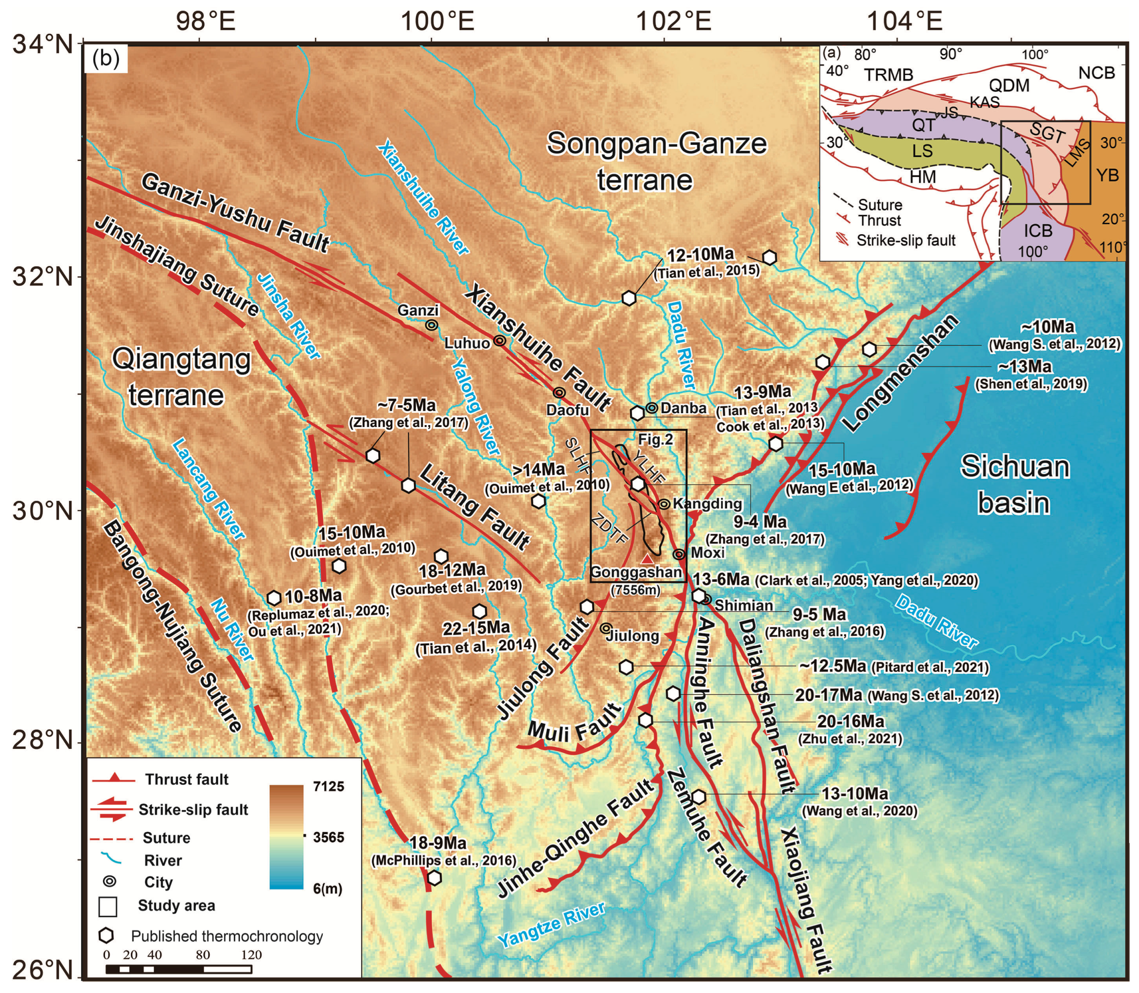
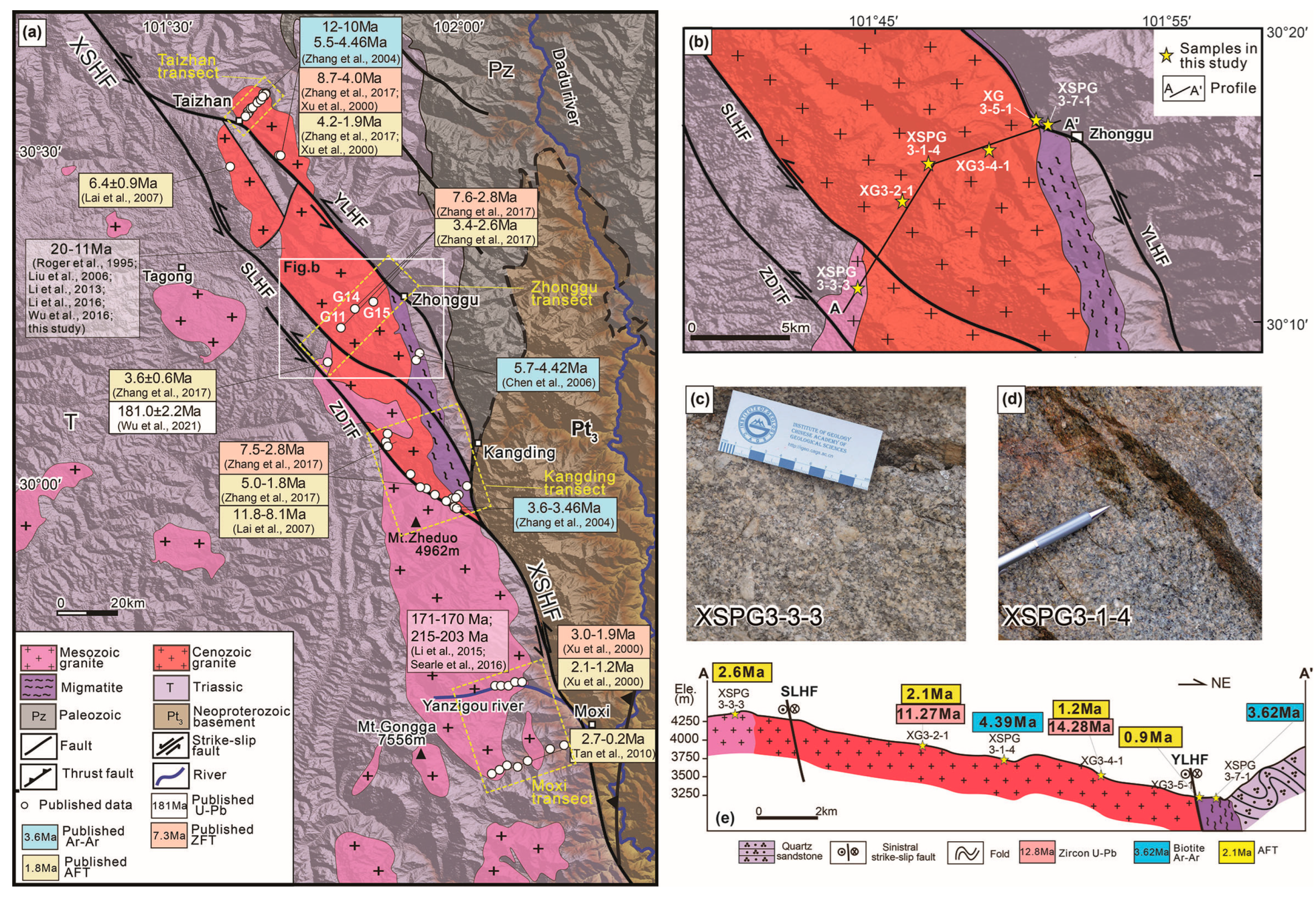
2. Geological Setting

The Zheduo–Gongga range, which is ~120 km long and 13–18 km wide, is an emblematic feature in the eastern Tibetan Plateau with a maximum elevation of 7556 m. To the northeast, a deeply incised Dadu River runs southward and then turns eastward into the Sichuan basin near Shimian (Figure 1b).
The study area is located along the active Xianshuihe fault system, which is composed of the Ganzi–Yushu, Xianshuihe, and Xiaojiang faults [31,49,58,59,60]. Such a fault system extends for more than 1400 km from Dangjiang, southeastwardly through Luhuo, Daofu, Kangding, Moxi, and Shimian, where it then branches into the Anninghe–Zemuhe and Daliangshan faults [53,61] and finally connects with the linear Xiaojiang fault (Figure 1; [62,63]). In the central segment, the Xianshuihe fault trends NE143° to NE165° from NW to SE and is characterized by sinistral movement, as shown by left-laterally offset bedrocks, and valleys [39,63,64] and other deflected markers in the mylonites within the fault zone, such as asymmetric ‘σ’ structure and ‘S–C’ fabric [60,65,66]. The total horizontal displacement of the Xianshuihe fault system is 60–100 km [67], of which ~60 km is accommodated by the Xianshuihe fault zone through offset geological and topographic markers, such as sinistrally displaced basement rocks [63], stream channels, and valleys [39,40,63,64,68].
The initiation age of the Xianshuihe fault was considered to be ~12.8 Ma based on the zircon U–Pb and whole–rock Rb–Sr chronology of the syntectonic Zheduo–Gongga granite [58]. Liu et al. (2006) proposed an age of ~18 Ma, based on zircon U–Pb ages of syntectonic granitic intrusions [8]. Li et al. (2016) suggested a left-lateral strike-slip motion of the Xianshuihe fault at 27–25 Ma, indicated by the deformed migmatite closely related to the Xianshuihe fault zone [11]. Whereas low-temperature thermochronology results indicate that the Xianshuihe fault started later, at ~9 Ma [34] or ~5 Ma [59,69]. Furthermore, its slip rates on the geological time scale also vary from 3.5 to 30 mm/yr, based on different initiation ages of ~2–4 Ma [70], ~13 Ma [58], ~17 ± 2 Ma [49], 5–13 Ma [63], and ~9 Ma [34].
The Zheduo–Gongga range consists mainly of granitoid (including biotite granite, granodiorite, and monzogranite) and migmatite [60,62,69,71]. The crystallization ages of the granitoid range from late Triassic (216–204 Ma) [63] to Jurassic (182–159 Ma) [69,71,72] and to Cenozoic (32–20 Ma, 18–12 Ma, and 5–4 Ma) [34,58,62,69,73,74,75] (Figure 2a). The migmatite zone is distributed along the eastern edge of the Zheduo–Gongga batholith, following the Yalahe segment of the Xianshuihe fault. It is composed of leucosomes and melanosomes [62,69,73]. The migmatite near Kangding consists of leucosome and foliated melanosomes that have relic magmatic texture, felsic component, and sub-vertical foliation [62,69,73]. Li & Zhang (2013) reported zircon SHRIMP (Sensitive High-resolution Ion Microprobe) U–Pb ages of 26.9 ± 0.9 Ma (rim) and 31.75 ± 0.66 Ma (rim) for the melanosome and leucosome, respectively, which were interpreted to indicate the metamorphic or migmatization ages [9]. The migmatite along Yanzigou Valley, south of Kanding city (Figure 2a), is characterized by foliated melanosome and leucosome with intruded leucogranite [69,73]. Li et al. (2016) presented NWW–SEE trending foliated melanosome with vertical foliation and sub-horizontal stretching lineation indicating sinistral motion of the Xianshuihe fault [11]. Zircon LA–ICP–MS (Laser Ablation Inductively Coupled Plasma Mass Spectrometer) U–Pb dating yielded a crystallization age of melanosome of about ~171 Ma and leucosome of ~25–20 Ma, which was complemented in Tianjin Institute of Geology and Mineral Resources, China Geological Survey [73]. While Searle et al. (2016) displayed melanosomes with a prominent fabric striking NW-SE160° and dipping NE50°at the eastern margin of the Zheduo–Gongga batholith along Yanzigou valley and also reported a crystallization age of ~215 Ma for the foliated biotite hornblende granodiorite [12].
The cooling/exhumation history of the Zheduo–Gongga massif has been estimated in previous studies using 40Ar–39Ar, zircon fission track (ZFT), and AFT methods [25,30,31,34,76]. Biotite 40Ar–39Ar ages indicate two cooling episodes: one cooling through biotite 40Ar–39Ar closure temperature of 300 ± 50 °C [77,78] at 12–10 Ma in the northwestern part and another at 5–3.5 Ma in the eastern part of the Zheduo–Gongga massif [25,31]. ZFT and AFT ages show a range between 8.7–2.8 Ma and 5–0.2 Ma, respectively [30,34,76]. Previous studies argued discrete cooling phases at ca. 22, 7, and 2 Ma [30] or rapid exhumation since ~1 Ma, with a rate exceeding ~3.3 mm/yr in the southern part of the complex [76], or at ~9 Ma, with a rate of ~1.85 km/Ma in the northern part [34].
Figure 2. (a) Morphology and geology of the Zheduo–Gongga massif and Xianshuihe fault zone (see location in Figure 1b; modified after [34]). White circles are published data from the following references: [25,30,31,34,58,62,69,71,72,73,74,75,76,79]. XSHF—Xianshuihe fault zone; YLHF—Yalahe fault; SLHF—Selaha fault; ZDTF—Zheduotang fault. (b) Geological map of the Zhonggu area (location in Figure) with our samples (yellow stars). (c,d) Field photos of samples XSPG3–3-3 and XSPG3–1-4. (e) Structural profile AA’ and our samples with multi–thermochronological data based on field observations.
Minerals 14 01108 g002

3. Sampling and Methods

3.1. Sampling

In order to reveal the exhumation history of the Zheduo–Gongga massif and the activity of the Xianshuihe fault, six granite samples were collected along the E–W Zhonggu profile across the massif for zircon U–Pb, biotite 40Ar–39Ar, and AFT dating (Table 1, Figure 2b). The granitoid samples were collected over a distance of ~20 km with an 1179 m change in elevation (Table 1, Figure 2b,e). Along the transect from SW to NE, the first four samples are far away from the Yalahe fault, including a monzogranite sample (XSPG3–3–3) (Figure 2c) and three biotite granites (Figure 2d). The other two samples, XG3-5-1 and XSPG3-7-1, are biotite granites within the migmatite zone (Figure 2b). Detailed geographic locations of these samples are given in Table 1.

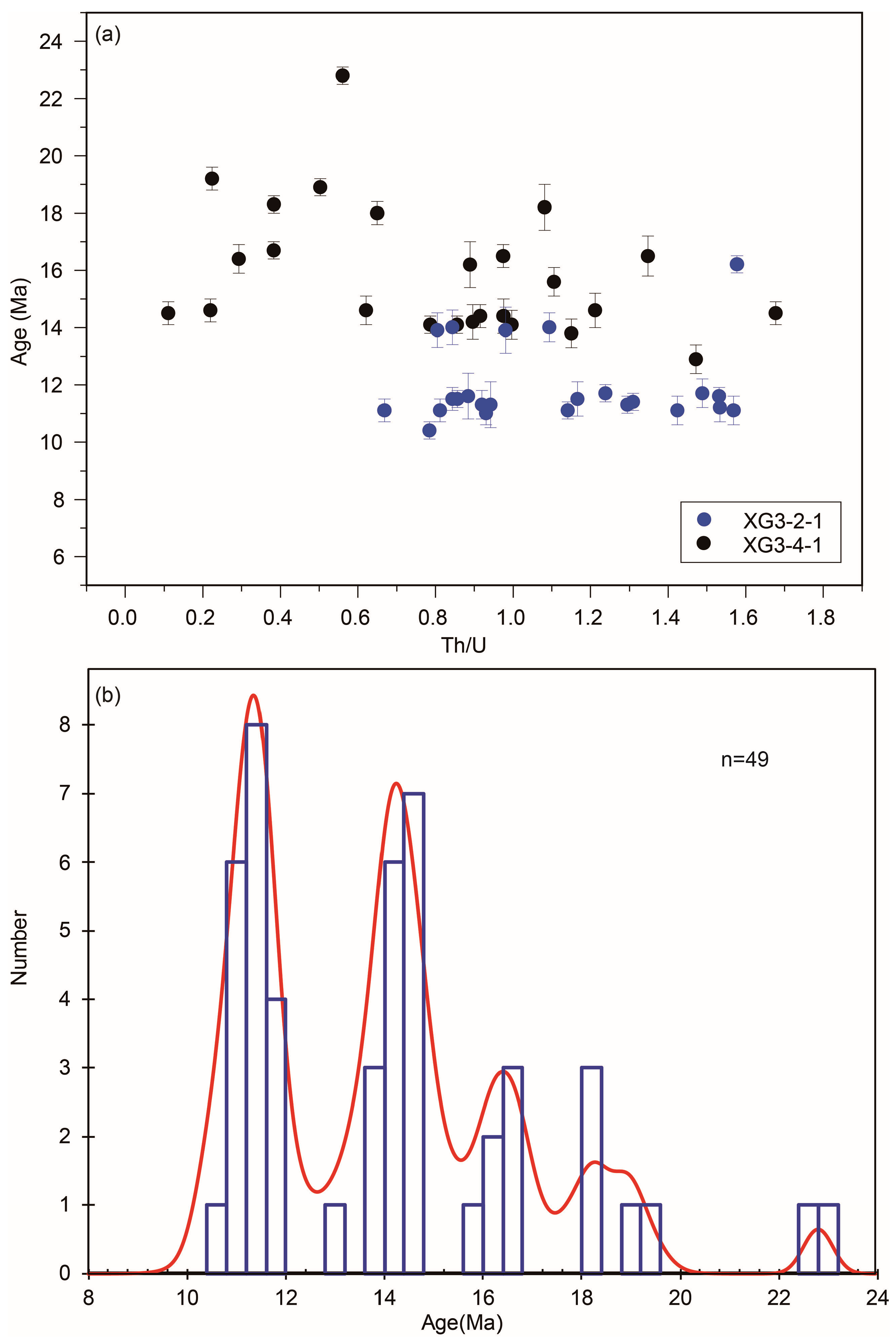
3.2. Zircon U-Pb Dating

Zircons in samples XG3-2-1 and XG3-4-1 were obtained through standard mineral separation procedures, which included crushing, sieving, heavy liquid, and magnetic separation. After the zircons were mounted onto an epoxy target and polished, cathodoluminescence (CL) images under transmitted and reflected light were taken using a Zeiss microscope (ZEISS, Jena, Germany) so as to select suitable grains for U-Pb dating. Zircon U–Pb dating was conducted using an Agilent 7500a LA–ICP–MS (Agilent Technologies, Palo Alto, CA, USA) attached to a New Wave 213 nm laser ablation system, at the State Key Laboratory for Mineral Deposits Research, Nanjing University (see Text S1 in the Supporting Information for details).

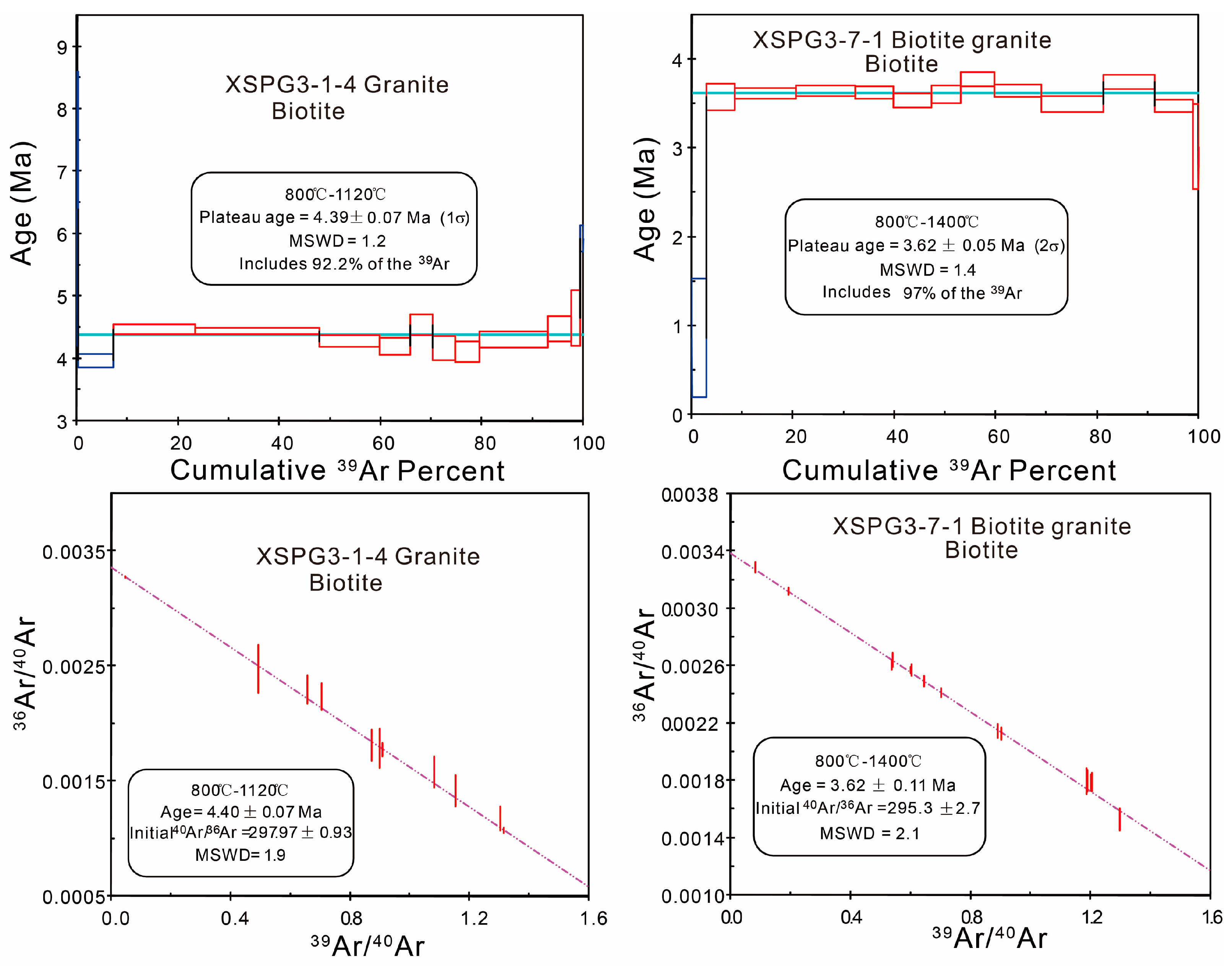
3.3. Biotite 40Ar–39Ar Dating

For igneous rocks, biotite 40Ar–39Ar thermochronology, in essence, records a cooling age rather than a crystallization age, when the temperature cooled to the closure temperature of Argon of 300 ± 50 °C [77,78,80]. To reveal the cooling/exhumation processes of the massif, biotite 40Ar–39Ar dating of two samples, XSPG3-1-4 and XSPG3-7-1, was carried out at the Institute of Geology, Chinese Academy of Geological Sciences. Biotite 40Ar–39Ar dating was complemented according to the procedure that was described by [81] (see details in Text S2 of the Supplementary Files).

3.4. AFT Dating

AFT thermochronology could reveal the ages of the rocks when they cool through the partial annealing zone of 60–120 °C [82]. Apatite crystals were concentrated using standard heavy liquid and magnetic separation procedures. AFT dating was complemented at the low-temperature thermochronology laboratory of the School of Earth Sciences, University of Melbourne. AFT ages in this study were complemented using the ICP–MS fission track dating method [83]. The detailed procedure of the AFT dating experiment is described in Text S3 of the Supplementary files.

3.5. Thermal Modeling

To better constrain the thermal history of the samples, biotite 40Ar–39Ar data and AFT results along with published ZFT were modeled on the basis of the multi-kinetic annealing model of [84] through the inverse approach of the HeFTy program. This program combines a Kolmogorov–Smirnov (K–S) test and the goodness of fit (GOF) to compare predictions (including ages and lengths) of a thermal history model to observations [85]. In order to reduce observation bias, c-axis projected lengths were used for thermal modeling, where the paths are termed as a good fit when the GOF ≥ 0.5 and an acceptable fit when GOF ≥ 0.05 [85].
The modeling inputs include the pooled AFT ages and length distribution. In addition, other ages are also used to constrain the modeling, including 40Ar–39Ar ages of two granitoid samples (XSPG3–1–4 and XSPG3–7–1) and published ZFT data from neighbor samples, such as samples G11, G14, and G15 from [34] (see locations in Figure 2a). Sample XSPG3–1–4 was located between samples XG3–2–1 and XG3–4–1 along the Zhonggu profile (Figure 2). Its 40Ar–39Ar age (4.39 ± 0.07 Ma) was used to constrain the thermal history modeling of samples XG3–2–1 and XG3–4–1. The 40Ar–39Ar age of sample XSPG3–7–1 was used to constrain the modeling of nearby sample XG3–5–1 (Figure 2). Published ZFT ages of samples G11, G14, and G15 from [34] along the same section were used to constrain the modeling of samples XSPG3–3–3 (~1 km west of sample G11), XG 3–2–1, and XG3–4–1, respectively.
In the modeling, the present mean surface temperature is set at 20 ± 5 °C. Prior time–temperature boxes were set at the closure temperatures of the biotite 40Ar–39Ar, ZFT, and AFT methods, i.e., 250–350 °C [77], 210–290 °C [86], and 60–120 °C [82], for the corresponding ages. These settings were always included with large uncertainties so as to give the inversion algorithms sufficient freedom to search for a wide range of possible thermal histories.

4. Results and Interpretation

4.1. LA–ICP–MS Zircon U–Pb Age

Two samples (XG3–2–1 and XG3–4–1) were collected along the Zhonggu profile in the central part of the Zheduo–Gongga massif, far from the migmatite zone at the eastern edge of the massif along the Xianshuihe fault (Figure 2). Sample XG3–2–1 is a fine-grained granite composed of plagioclase, quartz, biotite, and muscovite. Cathodoluminescence (CL) images of the zircons indicate a typical magma origin as indicated by pronounced oscillatory and sector zoning (Figure 3). The zircon grains are between 80 and 250 μm long, with length/width ratios ranging from 1 to 3. A total of 24 points on these zircons were analyzed, and the results are presented in Supplementary Table S1. The analyzed 24 zircon grains vary in their U contents (210–1168 ppm) and Th/U ratios (0.67–1.58) (Table S1, Figure 4a). The results show a range of ~16.2–10.4 Ma. Of all the ages, the clustered 19 zircon U–Pb ages yield a weighted mean 206Pb/238U age of 11.3 ± 0.2 Ma (MSWD = 0.85) (Figure 3). This is interpreted to represent the crystallization age of the rock.
Sample XG3–4–1 is also fine-grained granite and has a mineralogy similar to that of sample XG3–2–1 (Figure 3). The zircon grains are euhedral crystals, transparent and colorless, with grain lengths of 70 to 200 μm and length–width ratios of 3:1–1:1. A total of 25 points on these zircons were analyzed, and the results are listed in Supplementary Table S1. U contents of these grains range from 402 to 2375 ppm, with Th/U ratios of 0.11–1.68 (Table S1, Figure 4a). The results show that the ages range from 22.8 Ma to 12.9 Ma (Table S1, Figure 4a). Of all the data, except for one oldest age of 22.8 Ma and one youngest age of 12.9 Ma, six points cluster between 15.6 Ma and 16.7 Ma and five ages cluster between 18 Ma and 19.2 Ma. The remaining eleven spots yield a weighted mean 206Pb/238U age of 14.3 ± 0.3 Ma (MSWD = 0.36; Figure 3).
A plot of zircon U-Pb age against the Th/U ratio of the two samples suggests magmatic zircon ages range between 23 and 11 Ma, with Th/U ratios between 0.1 and 2.0 (Figure 4a). The magmatic zircons show age peaks at ~18 Ma, ~16 Ma, ~14 Ma, and ~11 Ma (Figure 4b), suggesting continuous magmatism during that time.

4.2. 40Ar–39Ar Results

To reveal the cooling profile of the granites, two samples, XSPG3–1–4 and XSPG3–7–1, were collected from the Zhonggu profile (Figure 2) for biotite 40Ar–39Ar dating. Sample XSPG3–1–4 is fine-grained granite in the middle part of the massif, well away from the Xianshuihe fault, whereas sample XSPG3–7–1 is from the migmatite zone close to the Yalahe fault. The analytical results are presented in Supplementary Table S2 and Figure 5.
Both samples yield flat age spectra. Sample XSPG3–1–4 gives a plateau age of 4.39 ± 0.07 Ma (MSWD = 1.2) and an isochron age of 4.4 ± 0.07 Ma (MSWD = 1.9) (Figure 5). The initial 40Ar/36Ar of sample XSPG3–1–4 is 297.97 ± 0.93 (Figure 5), which is similar to the modern atmospheric 40Ar/36Ar ratio of 295.5 [87]. Sample XSPG3–7–1 shows a biotite 40Ar–39Ar plateau age of 3.62 ± 0.05 Ma (MSWD = 1.4) and an isochron age of 3.62 ± 0.11 Ma (MSWD = 2.1), with an initial 40Ar/36Ar value of 295.3 ± 2.7 (Figure 5), similar to the modern atmospheric 40Ar/36Ar ratio.

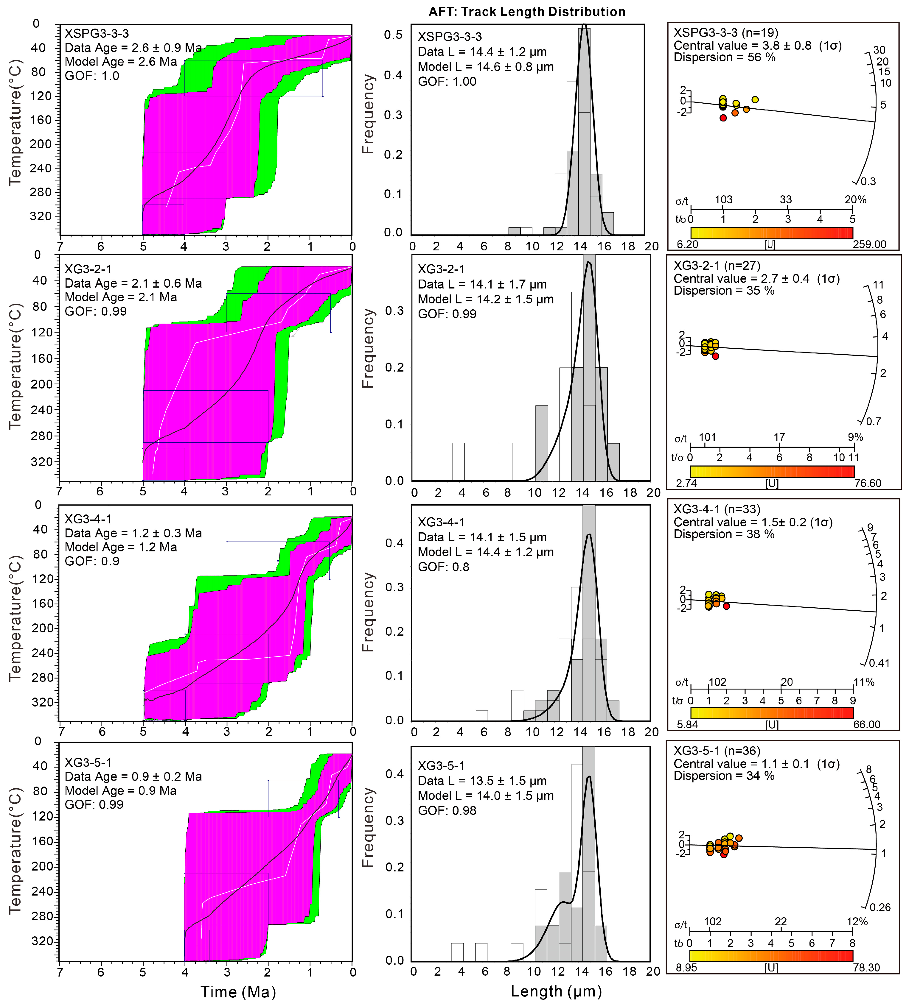
4.3. AFT Dating Results

Four granitoid samples along the Zhonggu transect (AA’ in Figure 2b,e) spaced over 20 km and 4398–3222 m in elevation were analyzed for AFT dating to reveal the cooling history of the massif. The analytical results are listed in Table 2 and displayed in Figure 6. All samples have relatively low and consistent Dpar values ranging between 1.3 and 1.4 μm (Table 2). To further constrain the detailed cooling history through modeling, confined track lengths for these samples were measured (Table 2) and are displayed in Figure 6.
AFT data of all samples passed the χ2–test, with P(χ2) greater than 5%, and yielded AFT pooled ages of 2.6 ± 0.8, 2.1 ± 0.4, 1.2 ± 0.2, and 0.9 ± 0.1 Ma, respectively (Table 2). Their corresponding central ages are 3.8 ± 0.8, 2.7 ± 0.4, 1.5 ± 0.2, and 1.1 ± 0.1 Ma with age dispersions over 30% (Figure 6). Their mean track lengths (MTLs) vary between 12.1 μm and 13.5 μm (Table 2). Sample XSPG3–3–3 with an elevation of 4398 m displays the longest MTL of 13.5 ± 0.2 μm with a standard deviation of 1.33 μm. Two samples (XG3–2–1 and XG3–4–1) within the granitic pluton, well away from the Xianshuihe fault, show MTLs of 12.8 ± 0.8 and 13.0 ± 0.3 μm, respectively. In contrast, sample XG3–5–1 within the migmatite zone has relatively shorter MTLs of 12.1 ± 0.6 μm with standard deviations of 2.82 μm (Table 2, Figure 6). Samples with longer track lengths indicate they may have experienced faster exhumation than those with shorter track lengths.

4.4. Thermal History Modeling Results

We attained thermal modeling results after 10,000 iterations, yielding both good (GOF ≥ 0.5) and acceptable paths (GOF ≥ 0.05) for each sample, which are imaged as time–temperature envelopes (Figure 6). The thermal modeling results present both best-fit and weighted mean thermal paths for each sample as indicated by white and black solid lines in Figure 6, respectively.
In the time–temperature envelopes of all samples, the weighted mean thermal path for all good models is similar with the best-fit thermal path except for the results of sample XG3-2-1. For sample XG3-2-1, the weighted mean thermal paths may be caused by uncertainty during modeling. However, compared to other results, the cooling history is convincible with a GOF of 0.99. Furthermore, the model length is more or less equal to the data length.
Thermal history models of three samples (XSPG3–3–3, XG3–2–1, and XG3–4–1) show a pronounced cooling episode beginning at ca. 5 Ma at a rate of 100–120 °C/Ma (Figure 6). And the modeled cooling rates show a small decreasing trend from sample XSPG3-3-3 to XG3-4-1 (Figure 6). Modeling outputs of samples XSPG3–3–3, XG3–2–1, and XG3–4–1 yield possible decelerated cooling at ca. 2.5 Ma, 2.0 Ma, and 1.5 Ma, respectively (Figure 6). The thermal history model of sample XG3-5-1 displays an approximately constant cooling rate since ~4 Ma. It does not show the same obvious cooling variation as the other three samples, which may be affected by the long activity of the Yalahe fault, a branch of the Xianshuihe fault.

5. Discussion

5.1. Late Cenozoic Cooling and Exhumation of the Zheduo–Gongga Massif

Combining published data (Supplementary Table S3) and our new zircon U–Pb, biotite 40Ar–39Ar, and AFT data, we plotted the ages for different thermochronometers versus their closure temperatures to further explore the cooling history of different portions of the Zheduo–Gongga massif. Considering the fast cooling of the massif, the closure temperatures, which are a function of cooling rate [80], were set as 850 ± 50 °C, 350 ± 15 °C, 240 ± 15 °C, and 110 ± 10 °C for the zircon U–Pb, biotite 40Ar–39Ar, ZFT, and AFT methods, respectively. The data are divided into four transects, which are from north to south, the Taizhan, Zhonggu, Kangding, and Moxi transects (Figure 2).
It is shown that the Zheduo–Gongga massif experienced multi-phase cooling and exhumation during the late Cenozoic (Figure 7). In the Taizhan profile, it cooled to 350 ± 15 °C at ~5 Ma at a rate of 54 ± 6 °C/Ma (Figure 7a) based on zircon ages of 18–14 Ma and biotite 40Ar–39Ar ages of 5.5–4.5 Ma [62,75]. This cooling rate corresponded to an exhumation rate of 1.2 ± 0.3 km/Ma assuming a geothermal gradient of 40–45 °C/km [34]. Then, it rapidly cooled through the ZFT and AFT closure temperatures till ~2 Ma at a rate of 89 ± 19 °C/Ma, followed by decelerated cooling (~41 ± 5 °C/Ma) (Figure 7a). Along the Zhonggu section, the cooling rates were 70 ± 8 °C/Ma during the period of ~11–4.4 Ma (Figure 7b), then 115 ± 18 °C/Ma from ~5 Ma to ~2 Ma, and followed by decelerated cooling (50 ± 15 °C/Ma) (Figure 7b). The corresponding exhumation rates of these areas were 1.4 ± 0.3 km/Ma, 2.8 ± 0.6 km/Ma, and 1.1 ± 0.4 km/Ma, respectively. To the south, across the Kangding transect, the massif was exhumed at a rate of 1.1 ± 0.2 km/Ma, resulting in a cooling rate of 53 ± 10 °C/Ma between 13 and 3.6 Ma (Figure 7c), and then exhumed rapidly at a rate of 5.5 ± 2.0 km/Ma (i.e., a cooling rate of 244 ± 93 °C/Ma), followed by decelerated exhumation and cooling (20 ± 13 °C/Ma), as calculated from the zircon U–Pb, biotite 40Ar–39Ar, AFT, and AHe data (Figure 7c). Here, we eliminate abnormally older ZFT ages than the 40Ar–39Ar ages. Similar cooling history is shown in the Moxi transect, with cooling rates of ~35 ± 3 °C/Ma during ~20–2.5 Ma, ~111 ± 40 °C/Ma during ~2.5–1.5 Ma, and ~68 ± 12 °C/Ma during ~1.5–0 Ma (Figure 7d).
In summary, the Zheduo–Gongga massif experienced a three-stage exhumation history during 11–5 Ma, ~5–2 Ma, and ~2–0 Ma, respectively. The early phase of cooling varied between 35 and 70 °C/Ma (corresponding to an exhumation rate of 0.6–1.3 km/Ma). Subsequent cooling occurred at a rapid rate of ~90–250 °C/Ma (corresponding to an exhumation rate of 2.0–5.5 km/Ma) followed by decreased cooling at a rate of ~20–70 °C/Ma (corresponding to an exhumation rate of 0.5–1.8 km/Ma). Further, the onset time of the phase of rapid exhumation and cooling may become younger southwards from ~5 Ma to ~2.5 Ma (Figure 7).

5.2. Magmatic Cooling or Rock Exhumation

The cooling of the massif may be argued as a result of either magmatism or rock exhumation. Recent studies reported magmatism lasting from ~20 Ma to ~5 Ma, with the main pulse occurring during ~18–11 Ma [58,74,75]. The intrusions younger than ~5 Ma are small aplitic dykes crosscutting the migmatite gneiss along the Kanding transect [34,69]. Given their small size (mostly less than 0.5 m wide), their thermal effect may not affect the thermochronological systems throughout the entire batholith. Further, thermochronological data generally vary with elevations [34], suggesting exhumation dominated the rock cooling of the region.

5.3. Activity of the Xianshuihe Fault

The onset timing of the sinistral shearing along the Xianshuihe fault has been intensively debated. Previous studies estimated the timing as 12.8–10 Ma, based on the ages of granitic mylonites and sub-horizontal stretching lineation on steep foliations along the fault zone [25,31,58,60]. Li & Zhang (2013) and Li et al. (2016) proposed that the Xianshuihe fault evolved from transpression to sinistral shearing at 27–25 Ma, constrained by two-stage migmatites at 32–27 Ma and 25–20 Ma associated with the early thrusting and left lateral strike-slip motion, respectively [53,64]. Searle et al. (2016) raised an initiation of the fault at ca. 5 Ma that cut off the youngest granite [69]. Zhang et al. (2017) argued that the Xianshuihe fault first became active at ca. 9 Ma, linking its onset to the rapid exhumation of the Zheduo–Gongga batholith [34]. If the ~14–11 Ma granites dated in this study are syntectonic, the intense activity of the fault may have occurred at the early–late Miocene, which is consistent with those age determinations from mylonites formed by the shearing.
The syntectonic magmatism indicates an intensive activity episode of the Xianshuihe fault zone during the early to middle Miocene [89,90,91,92]. Compared with the ~18–14 Ma magmatism within the northwest segment of the Zheduo–Gongga massif [75], the ~14–11 Ma magmatism in the middle segment of the massif observed here may indicate a phase of crustal thickening and southeastward migration of the melt along with the activity of the fault zone. Such a temporal and spatial distribution of the magmatism may link with the rotation of the Chuandian block, by weakening the middle–lower crust, so as to facilitate the rotation and extrusion of the Chuandian block [89,90,91,92]. The magmatism and sinistral slip are generally consistent with the kinematic reversal of the Ailao Shan–Red River fault zone (the southern boundary of the Chuandian block) sinistral to dextral slip at ~17 Ma [93,94,95].

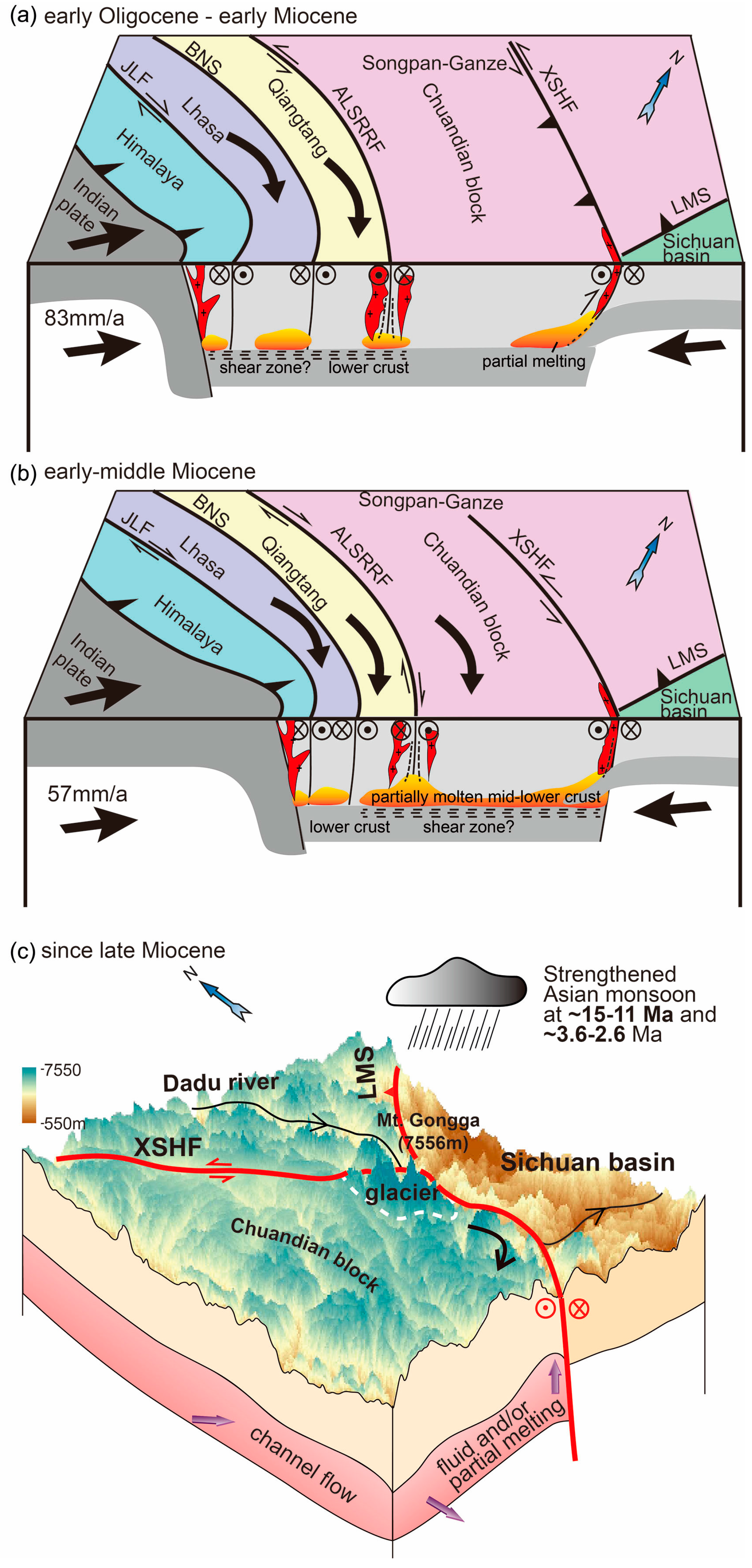
5.4. Dynamics of the Zheduo–Gongga Mountain Building and Exhumation

The anomalously high topography and exhumation of the Zheduo–Gongga massif have long been a puzzle. Previous studies attributed it to widespread late Miocene exhumation caused by the southeastward extrusion of the eastern Tibetan Plateau [25], bending of the Xianshuihe fault [34,76], and mid-Cenozoic crustal shortening [53]. Cook et al. (2018) proposed that the collocation of transpression, orographic precipitation, thermally weakened crust, and high relief at 3–4 Ma caused a series of feedbacks between erosion and uplift, which finally created the high topography of the Gongga mountain [36]. Bai et al. (2021) argued that it might be young magmatism and/or high regional heat flow that favored the high elevation of the Zheduo–Gongga mountain [64]. Zhang et al. (2022) inferred that the southeastern Tibetan Plateau might have experienced a progressive deformation history that evolved from spaced late Eocene–early Miocene crustal shortening along major faults, such as the Xianshuihe fault, which led to the weakening and lateral flow of the mid-lower crust during the late Miocene [8].
Combining previous structural and geochronological studies, we proposed the tectonomorphic evolution of the Zheduo–Gongga region might have experienced the following stages with different main driving mechanisms. Since the early Oligocene, the impedance of continuous northward indentation of Indian and west Burma blocks by the rigid Sichuan basin has forced the crust of the southeastern Tibetan Plateau to be shortened on a lithospheric scale (Figure 8a) [89,96,97,98,99]. Therefore, the surface uplift of the study area had probably commenced elevating during the same time. This phase of deformation is recorded in the migmatites with stretching lineation, which has been dated as ~32–27 Ma by zircon U–Pb analyses [62,73]. This result implied that the Zheduo–Gongga range on the hanging wall of the Xianshuihe fault was uplifted through crustal shortening within a NE–SW compressional stress field [100,101]. The continuous shortening and thickening possibly initiated the partial melting of the mid-lower crust, which probably decoupled from the deformation of the upper crust, in the expression of migmatization during ~25–20 Ma [73] and magmatism from ~20 to ~11 Ma within the elongated Zheduo–Gongga massif along the Xianshuihe fault zone (Figure 8b) [62,69,71,73,75,102,103].
In the late Miocene (11–5 Ma), when exhumation of the massif accelerated, the mid-lower crust might have been significantly weakened by the crust thickening during the earlier stage, as inferred by [8], forming an ~800 km-long anomalously fluidized, partial melt zone containing 5–20% fluid at a depth of 20–40 km beneath the Chuandian block, as shown by the magnetotelluric imaging, seismic data, and heat flux observations (Figure 8c) [5,45,46,104,105,106]. This layer might have facilitated the clockwise rotation of the Chuandian block around the east Himalayan syntaxis during 17–5 Ma [89,91,92] and could also accelerate the uplift regions surrounding the major fault zones [8]. As a result, widespread exhumation occurred in the southeastern Tibetan Plateau, such as in the hanging wall of the Jiulong (2–4 km denudation between 7 and 8 Ma) [33], Muli (~7.5 km exhumation since ~12.5 Ma) [51] and Jinhe–Qinghe faults (~1.7–2.4 km of exhumation between 20 and 16 Ma) [49,52], and the Luojishan area (denudation rate of 0.4 km/Ma between 13 and 10 Ma) [53,61]. Furthermore, the rotation of the Chuandian fragment bent the Xianshuihe fault zone under a sinistral shear stress regime and thus further induced compression and continued uplift and exhumation of the Gongga Mountain at the restraining bend (Figure 8c).
Simultaneously, the uplift of the plateau facilitated the late Miocene establishment and prevail of the East Asian monsoon by forming orographic barrier effects along the sharp margin of the plateau [20,41,42,44,107,108,109,110,111,112,113] (Figure 8c). The strengthened Asian monsoon enhanced the rainfall to the southern and eastern margins of the Tibetan Plateau and middle–east of China, even as far as the northern China [44,114]. The high precipitation resulted in widespread erosion and rapid river incision during 14–9 Ma, such as the Dadu and Anning rivers [4,50,115], east of the Gongga range, and other rivers draining the eastern plateau, including the Yalong, Yangtze, and Jinsha rivers, as shown by numerous thermochronological studies [4,37,54,55,56,115,116] (Figure 8c). The Miocene climatic change may enhance the unroofing of the Zheduo–Gongga area, as recorded by the 11–5 Ma episode of rock exhumation (Figure 8c). Such unroofing may disturb the crustal stress state and thereafter induce further tectonic deformation by isostasy [16,36,117]. This process is similar to the model proposed for structural culminations in the Himalayan syntaxes [15,16,23,109,117].
The potential decreased rate of unroofing of the Zheduo–Gongga massif since ~2.5 Ma may be linked to the Quaternary glaciation [118]. Under the global cooling background, glaciers in the SE Tibetan Plateau grew in high mountains [119], like the Gongga mountain. The Gongga glacier has been verified to advance several times during the late Quaternary by glacial landforms [33,120,121] and corresponding 10Be cosmogenic dating of moraines [121,122,123,124,125,126]. The erosional effect of Quaternary glaciation has been argued as either enhancing or decreasing rock exhumation [127,128,129]. The decreased Quaternary rate of rock exhumation in the study area supports the proposal that the glaciation acted as a barrier for river incision [128], so as to decrease the rate of rock exhumation. Further, comparing the faster exhumation rate during the earlier episode, it is argued that tectonic deformation, rather than climate changes, dominated the mountain building and rock exhumation in the study area.

6. Conclusions

Synthesis of new zircon LA–ICP–MS U–Pb, 40Ar–39Ar, and AFT data and previous structural and geochronological studies of the Zheduo–Gongga massif suggests an episodic exhumation history following the late Oligocene–early Miocene crustal shortening, granitic magmatism, and subsequent thermal weakening of the mid-lower crust. The episodic exhumation initiated at ~11 Ma and ~5 Ma, respectively, coinciding with the timing of the sinistral slip of the Xianshuihe fault and the late Cenozoic monsoon intensification. Based on the temporal synchroneity and mechanical consistency, we propose that the growth and exhumation of the massif resulted from transpressional deformation along the Xianhuihe fault and erosion enhanced by Asian monsoon precipitation and their interactions. During the Quaternary, the unroofing rate of the massif decreased, suggesting the climatic change played a minor role in the massif exhumation.

Supplementary Materials

The following supporting information can be downloaded at: https://www.mdpi.com/article/10.3390/min14111108/s1, Table S1: Analytical results of LA–ICP–MS zircon U–Pb dating of samples from the Zheduo–Gongga massif; Tables S2: The results of 40Ar–39Ar step heating data of biotite for samples from the Zheduo–Gongga massif; Table S3: Published thermochronological data within the Zheduo–Gongga massif; Table S4: Multi-thermochronological data for calculating the cooling history of the Zheduo–Gongga massif. References [81,83,88,130,131,132,133,134,135,136,137] are cited in the Supplementary Materials.

Author Contributions

Conceptualization, C.W. and G.L.; methodology, C.W. and G.L.; validation, G.L. and Y.T.; formal analysis, C.W., G.L., Y.T. and Z.Z.; investigation, C.W. and H.D.; writing—original draft preparation, C.W.; writing—review and editing, G.L., Y.T. and Z.Z.; funding acquisition, C.W., G.L. and Y.T. All authors have read and agreed to the published version of the manuscript.

Funding

This research was funded by the National Natural Science Foundation of China (grant numbers 42272111 and 42172229) and Fundamental Research Funds for the Central Universities (grant number 020614380072).

Data Availability Statement

All additional data are provided in the supporting information, including zircon U–Pb and biotite 40Ar–39Ar data in this study and summarized published thermochronological data.

Acknowledgments

We are grateful to Zhiqin Xu, Jingsui Yang, and Haibing Li for constructive suggestions, Paul T. Robinson for linguistic corrections, Alexander G. Webb, Hui Cao, Jianan Zhao, Hongcheng Guo, and Yuan Ma for assisting field work, Zheng Gong for guidance in plotting data, and Philippe Leloup and other anonymous professors for their constructive comments on an earlier version of the manuscript.

Conflicts of Interest

The authors declare no conflicts of interest.

References

  1. Royden, L.H.; Burchfiel, B.C.; King, R.W.; Wang, E.; Chen, Z.; Shen, F.; Liu, Y. Surface deformation and lower crustal flow in eastern Tibet. Science 1997, 276, 788–790. [Google Scholar] [CrossRef] [PubMed]
  2. Royden, L.H.; Burchfiel, B.C.; van der Hilst, R.D. The geological evolution of the Tibetan Plateau. Science 2008, 321, 1054–1058. [Google Scholar] [CrossRef] [PubMed]
  3. Clark, M.K.; Royden, L.H. Topographic ooze: Building the eastern margin of Tibet by lower crustal flow. Geology 2000, 28, 703–706. [Google Scholar] [CrossRef]
  4. Clark, M.K.; House, M.; Royden, L.; Whipple, K.; Burchfiel, B.; Zhang, X.; Tang, W. Late Cenozoic uplift of southeastern Tibet. Geology 2005, 33, 525–528. [Google Scholar] [CrossRef]
  5. Bai, D.; Unsworth, M.J.; Meju, M.A.; Ma, X.; Teng, J.; Kong, X.; Sun, Y.; Sun, J.; Wang, L.; Jiang, C. Crustal deformation of the eastern Tibetan plateau revealed by magnetotelluric imaging. Nat. Geosci. 2010, 3, 358–362. [Google Scholar] [CrossRef]
  6. Ji, L.; Liu, F.; Palin, R.; Wang, F.; Sun, Z. Thermal and physical properties of Barrovian metamorphic sequence rocks in the Ailao Shan-Red River shear zone, and implications for crustal channel flow. J. Geophys. Res. Solid Earth 2024, 129, e2023JB027253. [Google Scholar] [CrossRef]
  7. Zhao, P.; Chen, J.; Li, Y.; Liu, Q.; Chen, Y.; Guo, B.; Yin, X. Growth of the northeastern Tibetan plateau driven by crustal channel flow: Evidence from high-resolution ambient noise imaging. Geophys. Res. Lett. 2021, 48, e2021GL093387. [Google Scholar] [CrossRef]
  8. Zhang, G.; Tian, Y.; Li, R.; Shen, X.; Zhang, Z.; Sun, X.; Chen, D. Progressive tectonic evolution from crustal shortening to mid-lower crustal expansion in the southeast Tibetan Plateau: A synthesis of structural and thermochronological insights. Earth-Sci. Rev. 2022, 226, 103951. [Google Scholar] [CrossRef]
  9. Zhang, Z.; Nie, J.; Saylor, J.; Gao, S.; Xiao, W. Shortening and asthenospheric flow drove Miocene vertical-axis rotations in the northern Tibetan Plateau: A palaeomagnetic study of the northeast Qaidam Basin of China. Palaeogeogr. Palaeoclimatol. Palaeoecol. 2024, 647, 112263. [Google Scholar] [CrossRef]
  10. Tapponnier, P.; Zhiqin, X.; Roger, F.; Meyer, B.; Arnaud, N.; Wittlinger, G.; Jingsui, Y. Oblique stepwise rise and growth of the Tibet Plateau. Science 2001, 294, 1671–1677. [Google Scholar] [CrossRef]
  11. Yin, A. Cenozoic tectonic evolution of Asia: A preliminary synthesis. Tectonophysics 2010, 488, 293–325. [Google Scholar] [CrossRef]
  12. Tian, Y.; Kohn, B.P.; Hu, S.; Gleadow, A.J. Synchronous fluvial response to surface uplift in the eastern Tibetan Plateau: Implications for crustal dynamics. Geophys. Res. Lett. 2015, 42, 29–35. [Google Scholar] [CrossRef]
  13. Liu-Zeng, J.; Zhang, J.; McPhillips, D.; Reiners, P.; Wang, W.; Pik, R.; Zeng, L.; Hoke, G.; Xie, K.; Xiao, P. Multiple episodes of fast exhumation since Cretaceous in southeast Tibet, revealed by low-temperature thermochronology. Earth Planet. Sci. Lett. 2018, 490, 62–76. [Google Scholar] [CrossRef]
  14. Cao, K.; Wang, G.; Leloup, P.H.; Mahéo, G.; Xu, Y.; van Der Beek, P.A.; Replumaz, A.; Zhang, K. Oligocene-Early Miocene topographic relief generation of southeastern Tibet triggered by thrusting. Tectonics 2019, 38, 374–391. [Google Scholar] [CrossRef]
  15. Beaumont, C.; Jamieson, R.A.; Nguyen, M.; Lee, B. Himalayan tectonics explained by extrusion of a low-viscosity crustal channel coupled to focused surface denudation. Nature 2001, 414, 738–742. [Google Scholar] [CrossRef]
  16. Whipple, K.X. The influence of climate on the tectonic evolution of mountain belts. Nat. Geosci. 2009, 2, 97–104. [Google Scholar] [CrossRef]
  17. Li, M.; Seybold, H.; Wu, B.; Chen, Y.; Kirchner, J.W. Interaction between tectonics and climate encoded in the planform geometry of stream networks on the eastern Tibetan Plateau. Geophys. Res. Lett. 2023, 50, e2023GL104121. [Google Scholar] [CrossRef]
  18. Liu, F.; Danišík, M.; Zheng, D.; Gallagher, K.; Nie, J. Distinguishing tectonic versus climatic forcing on landscape evolution: An example from SE Tibetan Plateau. GSA Bull. 2021, 133, 233–242. [Google Scholar] [CrossRef]
  19. Lee, C.-T.A.; Thurner, S.; Paterson, S.; Cao, W. The rise and fall of continental arcs: Interplays between magmatism, uplift, weathering, and climate. Earth Planet. Sci. Lett. 2015, 425, 105–119. [Google Scholar] [CrossRef]
  20. Tada, R.; Zheng, H.; Clift, P.D. Evolution and variability of the Asian monsoon and its potential linkage with uplift of the Himalaya and Tibetan Plateau. Prog. Earth Planet. Sci. 2016, 3, 1–26. [Google Scholar] [CrossRef]
  21. Thiede, R.C.; Arrowsmith, J.R.; Bookhagen, B.; McWilliams, M.O.; Sobel, E.R.; Strecker, M.R. From tectonically to erosionally controlled development of the Himalayan orogen. Geology 2005, 33, 689–692. [Google Scholar] [CrossRef]
  22. Thiede, R.C.; Bookhagen, B.; Arrowsmith, J.R.; Sobel, E.R.; Strecker, M.R. Climatic control on rapid exhumation along the Southern Himalayan Front. Earth Planet. Sci. Lett. 2004, 222, 791–806. [Google Scholar] [CrossRef]
  23. Webb, A.A.G.; Guo, H.; Clift, P.D.; Husson, L.; Müller, T.; Costantino, D.; Yin, A.; Xu, Z.; Cao, H.; Wang, Q. The Himalaya in 3D: Slab dynamics controlled mountain building and monsoon intensification. Lithosphere 2017, 9, 637–651. [Google Scholar] [CrossRef]
  24. Schildgen, T.F.; van Der Beek, P.A.; Sinclair, H.D.; Thiede, R.C. Spatial correlation bias in late-Cenozoic erosion histories derived from thermochronology. Nature 2018, 559, 89–93. [Google Scholar] [CrossRef] [PubMed]
  25. Chen, W.; Zhang, Y.; Zhang, Y.; Jin, G.; Wang, Q. Late Cenozoic episodic uplifting in southeastern part of the Tibetan plateau-evidence from Ar-Ar thermochronology. Acta Petrol. Sin. 2006, 22, 867–872. [Google Scholar]
  26. Cook, K.; Royden, L.; Burchfiel, B.; Lee, Y.-H.; Tan, X. Constraints on Cenozoic tectonics in the southwestern Longmen Shan from low-temperature thermochronology. Lithosphere 2013, 5, 393–406. [Google Scholar] [CrossRef]
  27. Tan, X.-B.; Lee, Y.-H.; Xu, X.-W.; Cook, K.L. Cenozoic exhumation of the Danba antiform, eastern Tibet: Evidence from low-temperature thermochronology. Lithosphere 2017, 9, 534–544. [Google Scholar] [CrossRef]
  28. Tian, Y.; Kohn, B.P.; Gleadow, A.J.; Hu, S. Constructing the Longmen Shan eastern Tibetan Plateau margin: Insights from low-temperature thermochronology. Tectonics 2013, 32, 576–592. [Google Scholar] [CrossRef]
  29. Tian, Y.; Kohn, B.P.; Gleadow, A.J.; Hu, S. A thermochronological perspective on the morphotectonic evolution of the southeastern Tibetan Plateau. J. Geophys. Res. Solid Earth 2014, 119, 676–698. [Google Scholar] [CrossRef]
  30. Xu, G.; Kamp, P.J. Tectonics and denudation adjacent to the Xianshuihe Fault, eastern Tibetan Plateau: Constraints from fission track thermochronology. J. Geophys. Res. Solid Earth 2000, 105, 19231–19251. [Google Scholar] [CrossRef]
  31. Zhang, Y.; Chen, W.; Yang, N. 40Ar/39Ar dating of shear deformation of the Xianshuihe fault zone in west Sichuan and its tectonic significance. Sci. China Ser. D Earth Sci. 2004, 47, 794–803. [Google Scholar] [CrossRef]
  32. Yang, R.; Fellin, M.G.; Herman, F.; Willett, S.D.; Wang, W.; Maden, C. Spatial and temporal pattern of erosion in the Three Rivers Region, southeastern Tibet. Earth Planet. Sci. Lett. 2016, 433, 10–20. [Google Scholar] [CrossRef]
  33. Zhang, H.; Oskin, M.E.; Liu-Zeng, J.; Zhang, P.; Reiners, P.W.; Xiao, P. Pulsed exhumation of interior eastern Tibet: Implications for relief generation mechanisms and the origin of high-elevation planation surfaces. Earth Planet. Sci. Lett. 2016, 449, 176–185. [Google Scholar] [CrossRef]
  34. Zhang, Y.-Z.; Replumaz, A.; Leloup, P.H.; Wang, G.-C.; Bernet, M.; van der Beek, P.; Paquette, J.L.; Chevalier, M.-L. Cooling history of the Gongga batholith: Implications for the Xianshuihe Fault and Miocene kinematics of SE Tibet. Earth Planet. Sci. Lett. 2017, 465, 1–15. [Google Scholar] [CrossRef]
  35. Zhang, Y.Z.; Replumaz, A.; Wang, G.C.; Leloup, P.H.; Gautheron, C.; Bernet, M.; van der Beek, P.; Paquette, J.L.; Wang, A.; Zhang, K.X. Timing and rate of exhumation along the Litang fault system, implication for fault reorganization in Southeast Tibet. Tectonics 2015, 34, 1219–1243. [Google Scholar] [CrossRef]
  36. Cook, K.L.; Hovius, N.; Wittmann, H.; Heimsath, A.M.; Lee, Y.-H. Causes of rapid uplift and exceptional topography of Gongga Shan on the eastern margin of the Tibetan Plateau. Earth Planet. Sci. Lett. 2018, 481, 328–337. [Google Scholar] [CrossRef]
  37. Ouimet, W.; Whipple, K.; Royden, L.; Reiners, P.; Hodges, K.; Pringle, M. Regional incision of the eastern margin of the Tibetan Plateau. Lithosphere 2010, 2, 50–63. [Google Scholar] [CrossRef]
  38. Ouimet, W.B.; Whipple, K.X.; Granger, D.E. Beyond threshold hillslopes: Channel adjustment to base-level fall in tectonically active mountain ranges. Geology 2009, 37, 579–582. [Google Scholar] [CrossRef]
  39. Bai, M.; Chevalier, M.-L.; Pan, J.; Replumaz, A.; Leloup, P.H.; Métois, M.; Li, H. Southeastward increase of the late Quaternary slip-rate of the Xianshuihe fault, eastern Tibet. Geodynamic and seismic hazard implications. Earth Planet. Sci. Lett. 2018, 485, 19–31. [Google Scholar] [CrossRef]
  40. Yan, B.; Jia, D.; Lin, A. Late Pleistocene-Holocene tectonic landforms developed along the strike-slip Xianshuihe Fault Zone, Tibetan Plateau, China. J. Geodyn. 2018, 120, 11–22. [Google Scholar] [CrossRef]
  41. An, Z.; Kutzbach, J.E.; Prell, W.L.; Porter, S.C. Evolution of Asian monsoons and phased uplift of the Himalaya–Tibetan plateau since Late Miocene times. Nature 2001, 411, 62–66. [Google Scholar]
  42. Clift, P.D.; Webb, A.A.G. A history of the Asian monsoon and its interactions with solid Earth tectonics in Cenozoic South Asia. Geol. Soc. Lond. Spec. Publ. 2019, 483, 631–652. [Google Scholar] [CrossRef]
  43. Sun, J.; Ye, J.; Wu, W.; Ni, X.; Bi, S.; Zhang, Z.; Liu, W.; Meng, J. Late Oligocene–Miocene mid-latitude aridification and wind patterns in the Asian interior. Geology 2010, 38, 515–518. [Google Scholar] [CrossRef]
  44. Sun, X.; Wang, P. How old is the Asian monsoon system?—Palaeobotanical records from China. Palaeogeogr. Palaeoclimatol. Palaeoecol. 2005, 222, 181–222. [Google Scholar] [CrossRef]
  45. Liu, Q.Y.; Van Der Hilst, R.D.; Li, Y.; Yao, H.J.; Chen, J.H.; Guo, B.; Qi, S.H.; Wang, J.; Huang, H.; Li, S.C. Eastward expansion of the Tibetan Plateau by crustal flow and strain partitioning across faults. Nat. Geosci. 2014, 7, 361–365. [Google Scholar] [CrossRef]
  46. Tang, X.; Zhang, J.; Pang, Z.; Hu, S.; Tian, J.; Bao, S. The eastern Tibetan Plateau geothermal belt, western China: Geology, geophysics, genesis, and hydrothermal system. Tectonophysics 2017, 717, 433–448. [Google Scholar] [CrossRef]
  47. Shen, X.; Tian, Y.; Zhang, G.; Zhang, S.; Carter, A.; Kohn, B.; Vermeesch, P.; Liu, R.; Li, W. Late Miocene Hinterland Crustal Shortening in the Longmen Shan Thrust Belt, the Eastern Margin of the Tibetan Plateau. J. Geophys. Res. Solid Earth 2019, 124, 11972–11991. [Google Scholar] [CrossRef]
  48. Wang, E.; Kirby, E.; Furlong, K.P.; van Soest, M.; Xu, G.; Shi, X.; Kamp, P.J.J.; Hodges, K.V. Two-phase growth of high topography in eastern Tibet during the Cenozoic. Nat. Geosci. 2012, 5, 640–645. [Google Scholar] [CrossRef]
  49. Wang, S.; Jiang, G.; Xu, T.; Tian, Y.; Zheng, D.; Fang, X. The Jinhe–Qinghe fault—An inactive branch of the Xianshuihe–Xiaojiang fault zone, Eastern Tibet. Tectonophysics 2012, 544, 93–102. [Google Scholar]
  50. Yang, R.; Suhail, H.A.; Gourbet, L.; Willett, S.D.; Fellin, M.G.; Lin, X.; Gong, J.; Wei, X.; Maden, C.; Jiao, R. Early Pleistocene drainage pattern changes in Eastern Tibet: Constraints from provenance analysis, thermochronometry, and numerical modeling. Earth Planet. Sci. Lett. 2020, 531, 115955. [Google Scholar] [CrossRef]
  51. Pitard, P.; Replumaz, A.; Chevalier, M.L.; Leloup, P.H.; Bai, M.; Doin, M.P.; Thieulot, C.; Ou, X.; Balvay, M.; Li, H. Exhumation History Along the Muli Thrust—Implication for Crustal Thickening Mechanism in Eastern Tibet. Geophys. Res. Lett. 2021, 48, e2021GL093677. [Google Scholar] [CrossRef]
  52. Zhu, C.; Wang, G.; Leloup, P.H.; Cao, K.; Mahéo, G.; Chen, Y.; Zhang, P.; Shen, T.; Wu, G.; Sotiriou, P. Role of the early Miocene Jinhe-Qinghe Thrust Belt in the building of the Southeastern Tibetan Plateau topography. Tectonophysics 2021, 811, 228871. [Google Scholar] [CrossRef]
  53. Wang, H.; Li, K.; Tian, Y.; Zhang, G. Oligocene-Early Miocene exhumation and shortening along the Anninghe fault in the southeastern Tibetan Plateau: Insights from zircon and apatite (U-Th)/He thermochronology. Int. Geol. Rev. 2022, 64, 390–404. [Google Scholar] [CrossRef]
  54. Gourbet, L.; Yang, R.; Fellin, M.G.; Paquette, J.-L.; Willett, S.D.; Gong, J.; Maden, C. Evolution of the Yangtze River network, southeastern Tibet: Insights from thermochronology and sedimentology. Lithosphere 2020, 12, 3–18. [Google Scholar] [CrossRef]
  55. Replumaz, A.; San José, M.; Margirier, A.; van der Beek, P.; Gautheron, C.; Leloup, P.H.; Ou, X.; Cao, K.; Wang, G.c.; Zhang, Y.z. Tectonic control on rapid late Miocene—Quaternary incision of the Mekong River Knickzone, southeast Tibetan Plateau. Tectonics 2020, 39, e2019TC005782. [Google Scholar] [CrossRef]
  56. Ou, X.; Replumaz, A.; van der Beek, P. Contrasting exhumation histories and relief development within the Three Rivers Region (south-east Tibet). Solid Earth 2021, 12, 563–580. [Google Scholar] [CrossRef]
  57. McPhillips, D.; Hoke, G.D.; Liu-Zeng, J.; Bierman, P.R.; Rood, D.H.; Niedermann, S. Dating the incision of the Yangtze River gorge at the First Bend using three-nuclide burial ages. Geophys. Res. Lett. 2016, 43, 101–110. [Google Scholar] [CrossRef]
  58. Roger, F.; Calassou, S.; Lancelot, J.; Malavieille, J.; Mattauer, M.; Zhiqin, X.; Ziwen, H.; Liwei, H. Miocene emplacement and deformation of the Konga Shan granite (Xianshui He fault zone, west Sichuan, China): Geodynamic implications. Earth Planet. Sci. Lett. 1995, 130, 201–216. [Google Scholar] [CrossRef]
  59. Wang, S.; Fang, X.; Zheng, D.; Wang, E. Initiation of slip along the Xianshuihe fault zone, eastern Tibet, constrained by K/Ar and fission-track ages. Int. Geol. Rev. 2009, 51, 1121–1131. [Google Scholar] [CrossRef]
  60. Xu, Z.; Hou, L.; Wang, Z. The Orogeny of the Chinese Songpan-Ganze Orogen; Geological Publishing House: Beijing, China, 1992. (In Chinese) [Google Scholar]
  61. Wang, H.; Tian, Y.; Liang, M. Late Cenozoic exhumation history of the Luoji Shan in the southeastern Tibetan Plateau: Insights from apatite fission-track thermochronology. J. Geol. Soc. 2017, 174, 883–891. [Google Scholar] [CrossRef]
  62. Li, H.; Zhang, Y. Zircon U–Pb geochronology of the Konggar granitoid and migmatite: Constraints on the Oligo-Miocene tectono-thermal evolution of the Xianshuihe fault zone, East Tibet. Tectonophysics 2013, 606, 127–139. [Google Scholar] [CrossRef]
  63. Yan, B.; Lin, A. Systematic deflection and offset of the Yangtze River drainage system along the strike-slip Ganzi-Yushu-Xianshuihe Fault Zone, Tibetan Plateau. J. Geodyn. 2015, 87, 13–25. [Google Scholar] [CrossRef]
  64. Bai, M.; Chevalier, M.L.; Leloup, P.H.; Li, H.; Pan, J.; Replumaz, A.; Wang, S.; Li, K.; Wu, Q.; Liu, F. Spatial slip rate distribution along the SE Xianshuihe fault, eastern Tibet, and earthquake hazard assessment. Tectonics 2021, 40, e2021TC006985. [Google Scholar] [CrossRef]
  65. Wang, Z.; Xu, Z.; Yang, T.; Hao, M. Study of deformation mechanism of the Xianshui River fault zone—A shallow-level, high-temperature ductile shear zone. Reg. Geol. China 1996, 3, 245–251. [Google Scholar]
  66. Chen, Y.; Zhang, G.; Lu, R.; Luo, T.; Li, Y.; Yu, W. Formation and evolution of Xianshuihe Fault Belt in the eastern margin of the Tibetan Plateau: Constraints from structural deformation and geochronology. Geol. J. 2020, 55, 7953–7976. [Google Scholar] [CrossRef]
  67. Wang, E.; Burchfiel, B.C. Late Cenozoic to Holocene deformation in southwestern Sichuan and adjacent Yunnan, China, and its role in formation of the southeastern part of the Tibetan Plateau. Geol. Soc. Am. Bull. 2000, 112, 413–423. [Google Scholar] [CrossRef]
  68. Chevalier, M.-L.; Leloup, P.H.; Replumaz, A.; Pan, J.; Métois, M.; Li, H. Temporally constant slip rate along the Ganzi fault, NW Xianshuihe fault system, eastern Tibet. Bulletin 2018, 130, 396–410. [Google Scholar] [CrossRef]
  69. Searle, M.P.; Roberts, N.M.; Chung, S.-L.; Lee, Y.-H.; Cook, K.L.; Elliott, J.R.; Weller, O.M.; St-Onge, M.R.; Xu, X.-W.; Tan, X.-B. Age and anatomy of the Gongga Shan batholith, eastern Tibetan Plateau, and its relationship to the active Xianshui-he fault. Geosphere 2016, 12, 948–970. [Google Scholar] [CrossRef]
  70. Wang, E. Late Cenozoic Xianshuihe-Xiaojiang, Red River, and Dali Fault Systems of Southwestern Sichuan and Central Yunnan, China; Geological Society of America: Boulder, CO, USA, 1998; Volume 327. [Google Scholar]
  71. Li, H.; Zhang, Y.; Zhang, C.; Dong, S.; Zhu, F. Middle Jurassic syn-kinematic magmatism, anatexis and metamorphism in the Zheduo-Gonggar massif, implication for the deformation of the Xianshuihe fault zone, East Tibet. J. Asian Earth Sci. 2015, 107, 35–52. [Google Scholar] [CrossRef]
  72. Wu, C.; Ji, S.; Cao, H.; Dong, H.; Chen, X. Jurassic post-collisional extension in the Songpan–Ganze Terrane, eastern Tibetan Plateau: Evidence from weakly peraluminous A-type granites within the Zheduo–Gongga Massif. Geol. J. 2021, 56, 1911–1931. [Google Scholar] [CrossRef]
  73. Li, H.-L.; Zhang, Y.-Q.; Zhang, C.-H.; Wang, J.-C. Zircon U-Pb study of two-staged Oligo-Miocene migmatization along the Xianshuihe fault zone, East Tibet Plateau. Earth Sci. Front. 2016, 23, 222. [Google Scholar]
  74. Liu, S.; Wang, Z.; Yan, Q.; Li, Q.; Zhang, D.; Wang, J. Timing, petrogenesis and geodynamic significance of Zheduoshan Granitoids. Acta Petrol. Sin. 2006, 22, 343–352. [Google Scholar]
  75. Wu, C.; Xu, Z.; Webb, A.; Dong, H.; Cao, H.; Cheng, Z. The relationship between the Xianshuihe Fault Zone and Yala Snow Mountain Gneiss Dome in the Songpan-Ganzi Orogenic Belt. Acta Geol. Sin. 2016, 90, 2982–2998. [Google Scholar]
  76. Tan, X.-B.; Xu, X.-W.; Lee, Y.-H.; Chen, G.-H.; Wan, J.-L. Apatite fission track evidence for rapid uplift of the Gongga Mountain and discussion of its mechanism. Chin. J. Geophys. 2010, 53, 1859–1867. [Google Scholar]
  77. Grove, M.; Harrison, T.M. 40Ar* diffusion in Fe-rich biotite. Am. Mineral. 1996, 81, 940–951. [Google Scholar] [CrossRef]
  78. Reiners, P.W.; Carlson, R.W.; Renne, P.R.; Cooper, K.M.; Granger, D.E.; McLean, N.M.; Schoene, B. Geochronology and Thermochronology; John Wiley & Sons: Hoboken, NJ, USA, 2017. [Google Scholar]
  79. Lai, Q.; Ding, L.; Wang, H.; Yue, Y.; Cai, F. Constraining the stepwise migration of the eastern Tibetan Plateau margin by apatite fission track thermochronology. Sci. China Ser. D Earth Sci. 2007, 50, 172–183. [Google Scholar] [CrossRef]
  80. Reiners, P.W.; Brandon, M.T. Using thermochronology to understand orogenic erosion. Annu. Rev. Earth Planet. Sci. 2006, 34, 419–466. [Google Scholar] [CrossRef]
  81. Steiger, R.; Jäger, E. Subcommission on geochronology: Convention on the use of decay constants in geo-and cosmochronology. Earth Planet. Sci. Lett. 1977, 36, 359–362. [Google Scholar] [CrossRef]
  82. Gleadow, A.J.; Belton, D.X.; Kohn, B.P.; Brown, R.W. Fission track dating of phosphate minerals and the thermochronology of apatite. Rev. Mineral. Geochem. 2002, 48, 579–630. [Google Scholar] [CrossRef]
  83. Hasebe, N.; Barbarand, J.; Jarvis, K.; Carter, A.; Hurford, A.J. Apatite fission-track chronometry using laser ablation ICP-MS. Chem. Geol. 2004, 207, 135–145. [Google Scholar] [CrossRef]
  84. Ketcham, R.A.; Carter, A.; Donelick, R.A.; Barbarand, J.; Hurford, A.J. Improved measurement of fission-track annealing in apatite using c-axis projection. Am. Mineral. 2007, 92, 789–798. [Google Scholar] [CrossRef]
  85. Ketcham, R.A. Forward and inverse modeling of low-temperature thermochronometry data. Rev. Mineral. Geochem. 2005, 58, 275–314. [Google Scholar] [CrossRef]
  86. Bernet, M. A field-based estimate of the zircon fission-track closure temperature. Chem. Geol. 2009, 259, 181–189. [Google Scholar] [CrossRef]
  87. Nier, A.O. A redetermination of the relative abundances of the isotopes of carbon, nitrogen, oxygen, argon, and potassium. Phys. Rev. 1950, 77, 789. [Google Scholar] [CrossRef]
  88. Vermeesch, P. RadialPlotter: A Java application for fission track, luminescence and other radial plots. Radiat. Meas. 2009, 44, 409–410. [Google Scholar] [CrossRef]
  89. Gao, L.; Yang, Z.; Tong, Y.; Wang, H.; An, C.; Zhang, H. Cenozoic clockwise rotation of the Chuan Dian Fragment, southeastern edge of the Tibetan Plateau: Evidence from a new paleomagnetic study. J. Geodyn. 2017, 112, 46–57. [Google Scholar] [CrossRef]
  90. Tong, Y.; Yang, Z.; Pei, J.; Wang, H.; Wu, Z.; Li, J. Crustal clockwise rotation of the southeastern edge of the Tibetan Plateau since the late Oligocene. J. Geophys. Res. Solid Earth 2021, 126, e2020JB020153. [Google Scholar] [CrossRef]
  91. Tong, Y.-B.; Yang, Z.; Wang, H.; Gao, L.; An, C.-Z.; Zhang, X.-D.; Xu, Y.-C. The Cenozoic rotational extrusion of the Chuan Dian Fragment: New paleomagnetic results from Paleogene red-beds on the southeastern edge of the Tibetan Plateau. Tectonophysics 2015, 658, 46–60. [Google Scholar] [CrossRef]
  92. Wang, E.; Meng, K.; Su, Z.; Meng, Q.; Chu, J.J.; Chen, Z.; Wang, G.; Shi, X.; Liang, X. Block rotation: Tectonic response of the Sichuan basin to the southeastward growth of the Tibetan Plateau along the Xianshuihe-Xiaojiang fault. Tectonics 2014, 33, 686–718. [Google Scholar] [CrossRef]
  93. Cao, S.; Liu, J.; Leiss, B.; Neubauer, F.; Genser, J.; Zhao, C. Oligo-Miocene shearing along the Ailao Shan–Red River shear zone: Constraints from structural analysis and zircon U/Pb geochronology of magmatic rocks in the Diancang Shan massif, SE Tibet, China. Gondwana Res. 2011, 19, 975–993. [Google Scholar] [CrossRef]
  94. Leloup, P.; Tapponnier, P.; Lacassin, R.; Searle, M. Discussion on the role of the Red River shear zone, Yunnan and Vietnam, in the continental extrusion of SE Asia Journal, Vol. 163, 2006, 1025–1036. J. Geol. Soc. 2007, 164, 1253–1260. [Google Scholar] [CrossRef]
  95. Wang, Y.; Zhang, B.; Schoenbohm, L.M.; Zhang, J.; Zhou, R.; Hou, J.; Ai, S. Late Cenozoic tectonic evolution of the Ailao Shan-Red River fault (SE Tibet): Implications for kinematic change during plateau growth. Tectonics 2016, 35, 1969–1988. [Google Scholar] [CrossRef]
  96. Licht, A.; Dupont-Nivet, G.; Win, Z.; Swe, H.H.; Kaythi, M.; Roperch, P.; Ugrai, T.; Littell, V.; Park, D.; Westerweel, J. Paleogene evolution of the Burmese forearc basin and implications for the history of India-Asia convergence. GSA Bull. 2019, 131, 730–748. [Google Scholar] [CrossRef]
  97. Morley, C.; Arboit, F. Dating the onset of motion on the Sagaing fault: Evidence from detrital zircon and titanite U-Pb geochronology from the North Minwun Basin, Myanmar. Geology 2019, 47, 581–585. [Google Scholar] [CrossRef]
  98. Westerweel, J.; Licht, A.; Cogné, N.; Roperch, P.; Dupont-Nivet, G.; Kay Thi, M.; Swe, H.H.; Huang, H.; Win, Z.; Wa Aung, D. Burma Terrane collision and northward indentation in the Eastern Himalayas recorded in the Eocene-Miocene Chindwin Basin (Myanmar). Tectonics 2020, 39, e2020TC006413. [Google Scholar] [CrossRef]
  99. Cao, K.; Tian, Y.; van der Beek, P.; Wang, G.; Shen, T.; Reiners, P.; Bernet, M.; Husson, L. Southwestward growth of plateau surfaces in eastern Tibet. Earth-Sci. Rev. 2022, 232, 104160. [Google Scholar] [CrossRef]
  100. Chung, S.-L.; Chu, M.-F.; Zhang, Y.; Xie, Y.; Lo, C.-H.; Lee, T.-Y.; Lan, C.-Y.; Li, X.; Zhang, Q.; Wang, Y. Tibetan tectonic evolution inferred from spatial and temporal variations in post-collisional magmatism. Earth-Sci. Rev. 2005, 68, 173–196. [Google Scholar] [CrossRef]
  101. Tong, Y.; Yang, Z.; Pei, J.; Wang, H.; Wu, Z.; Li, J. Upper Crustal Collapse Reconstructed the Topography and Remodeled the Fault System of the Chuandian Fragment in the Southeastern Edge of the Tibetan Plateau, Evidenced by Anisotropy of Magnetic Susceptibility Data Sets. Tectonics 2022, 41, e2021TC007126. [Google Scholar] [CrossRef]
  102. de Sigoyer, J.; Vanderhaeghe, O.; Duchêne, S.; Billerot, A. Generation and emplacement of Triassic granitoids within the Songpan Ganze accretionary-orogenic wedge in a context of slab retreat accommodated by tear faulting, Eastern Tibetan plateau, China. J. Asian Earth Sci. 2014, 88, 192–216. [Google Scholar] [CrossRef]
  103. Hu, F.; Wu, F.Y.; Ducea, M.N.; Chapman, J.B.; Yang, L. Does Large-scale Crustal Flow Shape the Eastern Margin of the Tibetan Plateau? Insights From Episodic Magmatism of Gongga-Zheduo Granitic Massif. Geophys. Res. Lett. 2022, e2022GL098756. [Google Scholar] [CrossRef]
  104. He, X.; Zhao, L.F.; Xie, X.B.; Tian, X.; Yao, Z.X. Weak crust in southeast Tibetan plateau revealed by Lg-wave attenuation tomography: Implications for crustal material escape. J. Geophys. Res. Solid Earth 2021, 126, e2020JB020748. [Google Scholar] [CrossRef]
  105. Jiang, F.; Chen, X.; Unsworth, M.J.; Cai, J.; Han, B.; Wang, L.; Dong, Z.; Cui, T.; Zhan, Y.; Zhao, G. Mechanism for the Uplift of Gongga Shan in the Southeastern Tibetan Plateau Constrained by 3D Magnetotelluric Data. Geophys. Res. Lett. 2022, 49, e2021GL097394. [Google Scholar] [CrossRef]
  106. Rippe, D.; Unsworth, M. Quantifying crustal flow in Tibet with magnetotelluric data. Phys. Earth Planet. Inter. 2010, 179, 107–121. [Google Scholar] [CrossRef]
  107. Allen, M.B.; Armstrong, H.A. Reconciling the Intertropical Convergence Zone, Himalayan/Tibetan tectonics, and the onset of the Asian monsoon system. J. Asian Earth Sci. 2012, 44, 36–47. [Google Scholar] [CrossRef]
  108. An, Z.; Wu, G.; Li, J.; Sun, Y.; Liu, Y.; Zhou, W.; Cai, Y.; Duan, A.; Li, L.; Mao, J. Global monsoon dynamics and climate change. Annu. Rev. Earth Planet. Sci. 2015, 43, 29–77. [Google Scholar]
  109. Clift, P.D.; Hodges, K.V.; Heslop, D.; Hannigan, R.; Van Long, H.; Calves, G. Correlation of Himalayan exhumation rates and Asian monsoon intensity. Nat. Geosci. 2008, 1, 875–880. [Google Scholar] [CrossRef]
  110. Liu, X.; Dong, B.; Yin, Z.-Y.; Smith, R.S.; Guo, Q. Continental drift, plateau uplift, and the evolutions of monsoon and arid regions in Asia, Africa, and Australia during the Cenozoic. Sci. China Earth Sci. 2019, 62, 1053–1075. [Google Scholar] [CrossRef]
  111. Molnar, P. Mio-Pliocene growth of the Tibetan Plateau and evolution of East Asian climate. Palaeontol. Electron. 2005, 8, 1–23. [Google Scholar]
  112. Thomson, J.R.; Holden, P.B.; Anand, P.; Edwards, N.R.; Porchier, C.A.; Harris, N.B. Tectonic and climatic drivers of Asian monsoon evolution. Nat. Commun. 2021, 12, 1–10. [Google Scholar] [CrossRef]
  113. Wan, S.; Kürschner, W.M.; Clift, P.D.; Li, A.; Li, T. Extreme weathering/erosion during the Miocene Climatic Optimum: Evidence from sediment record in the South China Sea. Geophys. Res. Lett. 2009, 36. [Google Scholar] [CrossRef]
  114. Hui, Z.; Zhou, X.; Chevalier, M.; Wei, X.; Pan, Y.; Chen, Y. Miocene East Asia summer monsoon precipitation variability and its possible driving forces. Palaeogeogr. Palaeoclimatol. Palaeoecol. 2021, 581, 110609. [Google Scholar] [CrossRef]
  115. Wilson, C.J.; Fowler, A.P. Denudational response to surface uplift in east Tibet: Evidence from apatite fission-track thermochronology. Bulletin 2011, 123, 1966–1987. [Google Scholar] [CrossRef]
  116. Nie, J.; Ruetenik, G.; Gallagher, K.; Hoke, G.; Garzione, C.N.; Wang, W.; Stockli, D.; Hu, X.; Wang, Z.; Wang, Y. Rapid incision of the Mekong River in the middle Miocene linked to monsoonal precipitation. Nat. Geosci. 2018, 11, 944–948. [Google Scholar] [CrossRef]
  117. Zeitler, P.K.; Meltzer, A.S.; Koons, P.O.; Craw, D.; Hallet, B.; Chamberlain, C.P.; Kidd, W.S.; Park, S.K.; Seeber, L.; Bishop, M. Erosion, Himalayan geodynamics, and the geomorphology of metamorphism. Gsa Today 2001, 11, 4–9. [Google Scholar] [CrossRef]
  118. Zachos, J.C.; Shackleton, N.J.; Revenaugh, J.S.; Palike, H.; Flower, B.P. Climate response to orbital forcing across the Oligocene-Miocene boundary. Science 2001, 292, 274–278. [Google Scholar] [CrossRef]
  119. Li, S.; Currie, B.S.; Rowley, D.B.; Ingalls, M. Cenozoic paleoaltimetry of the SE margin of the Tibetan Plateau: Constraints on the tectonic evolution of the region. Earth Planet. Sci. Lett. 2015, 432, 415–424. [Google Scholar] [CrossRef]
  120. Fu, P.; Harbor, J.M.; Stroeven, A.P.; Hättestrand, C.; Heyman, J.; Zhou, L. Glacial geomorphology and paleoglaciation patterns in Shaluli Shan, the southeastern Tibetan Plateau—Evidence for polythermal ice cap glaciation. Geomorphology 2013, 182, 66–78. [Google Scholar] [CrossRef]
  121. Heyman, J. Paleoglaciation of the Tibetan Plateau and surrounding mountains based on exposure ages and ELA depression estimates. Quat. Sci. Rev. 2014, 91, 30–41. [Google Scholar] [CrossRef]
  122. Chevalier, M.-L.; Replumaz, A. Deciphering old moraine age distributions in SE Tibet showing bimodal climatic signal for glaciations: Marine Isotope Stages 2 and 6. Earth Planet. Sci. Lett. 2019, 507, 105–118. [Google Scholar] [CrossRef]
  123. Owen, L.A.; Dortch, J.M. Nature and timing of Quaternary glaciation in the Himalayan–Tibetan orogen. Quat. Sci. Rev. 2014, 88, 14–54. [Google Scholar] [CrossRef]
  124. Owen, L.A.; Finkel, R.C.; Barnard, P.L.; Haizhou, M.; Asahi, K.; Caffee, M.W.; Derbyshire, E. Climatic and topographic controls on the style and timing of Late Quaternary glaciation throughout Tibet and the Himalaya defined by 10Be cosmogenic radionuclide surface exposure dating. Quat. Sci. Rev. 2005, 24, 1391–1411. [Google Scholar] [CrossRef]
  125. Wang, J.; Pan, B.; Zhang, G.; Cui, H.; Cao, B.; Geng, H. Late Quaternary glacial chronology on the eastern slope of Gongga Mountain, eastern Tibetan Plateau, China. Sci. China Earth Sci. 2013, 56, 354–365. [Google Scholar] [CrossRef]
  126. Xu, X.; Yi, C. Timing and configuration of the Gongga II glaciation in the Hailuogou valley, eastern Tibetan Plateau: A glacier-climate modeling method. Quat. Int. 2017, 444, 151–156. [Google Scholar] [CrossRef]
  127. Herman, F.; Seward, D.; Valla, P.G.; Carter, A.; Kohn, B.; Willett, S.D.; Ehlers, T.A. Worldwide acceleration of mountain erosion under a cooling climate. Nature 2013, 504, 423–426. [Google Scholar] [CrossRef]
  128. Korup, O.; Montgomery, D.R.; Hewitt, K. Glacier and landslide feedbacks to topographic relief in the Himalayan syntaxes. Proc. Natl. Acad. Sci. USA 2010, 107, 5317–5322. [Google Scholar] [CrossRef] [PubMed]
  129. Zhang, P.; Peter, M.; William, R.D. Increased sedimentation rates and grain sizes 2–4 Myr ago due to the influence of climate change on erosion rates. Nature 2001, 410, 891–897. [Google Scholar]
  130. Jackson, S.E.; Pearson, N.J.; Griffin, W.L.; Belousova, E.A. The application of laser ablation-inductively coupled plasma-mass spectrometry to in situ U-Pb zircon geochronology. Chem. Geol. 2004, 211, 47–69. [Google Scholar] [CrossRef]
  131. Black, L.P.; Kamo, S.L.; Williams, I.S.; Mundil, R.; Davis, D.W.; Korsch, R.J.; Foudoulis, C. The application of SHRIMP to Phanerozoic geochronology: A critical appraisal of four zircon standards. Chem. Geol. 2003, 200, 171–188. [Google Scholar] [CrossRef]
  132. Ludwig, K.R. User’s manual for Isoplot 3.00: A geochronological toolkit for Microsoft Excel (No. 4); Kenneth R. Ludwig: Berkeley, CA, USA, 2003. [Google Scholar]
  133. Andersen, T. Correction of common lead in U–Pb analyses that do not report 204Pb. Chem. Geol. 2002, 192, 59–79. [Google Scholar] [CrossRef]
  134. Chen, W.; Liu, X.Y.; Zhang, S.H. Continuous laser stepwise heating 40Ar/39Ar dating technique. Geol. Rev. 2002, 48, 127–134. [Google Scholar]
  135. Gleadow, A.J.W.; Gleadow, S.J.; Belton, D.X.; Kohn, B.P.; Krochmal, M.S.; Brown, R.W. Coincidence mapping—A key strategy for the automatic counting of fission tracks in natural minerals. Geol. Soc. Lond. Spec. Publ. 2009, 324, 25–36. [Google Scholar] [CrossRef]
  136. Li, G.; Kohn, B.; Sandiford, M.; Xu, Z.; Wei, L. Constraining the age of Liuqu Conglomerate, southern Tibet: Implications for evolution of the India–Asia collision zone. Earth Planet. Sci. Lett. 2015, 426, 259–266. [Google Scholar] [CrossRef]
  137. Galbraith, R.F. Statistics for Fission Track Analysis; Chapman & Hall/CRC: Boca Raton, FL, USA, 2005; p. 219. [Google Scholar]
Figure 3. Zircon CL images and zircon U–Pb Concordia diagrams for samples XG3–2–1 (ac) and XG3–4–1 (df) in this study.
Minerals 14 01108 g003
Figure 4. (a) A diagram of zircon U-Pb ages versus Th/U ratios of granitic samples XG3–2–1 (blue dots) and XG3–4–1 (black dots) in this study; (b) Cumulative distribution of magmatic zircon U-Pb ages in this study.
Minerals 14 01108 g004
Figure 5. 40Ar–39Ar age spectra of samples (XSPG3–1–4 and XSPG3–7–1) from the Zheduo–Gongga massif along the Zhonggu profile. The red lines in the upper two panels show 40Ar–39Ar ages at each stepwise heating. The green ones indicate the plateau age. The blue ones display the ages at the first and last stepwise heatings.
Minerals 14 01108 g005
Figure 6. Thermal history modeling results of samples in this study. Left panel: “Good” paths (GOF > 0.5) are shown as pink envelopes and “acceptable” paths (GOF > 0.05) as green envelopes. The black line represents the weighted mean thermal path for all good models, and the white one is the best-fit thermal path for each sample. Constraints are shown as black boxes. Middle panel: Length distribution histograms. The diagram filled in white represents the measured lengths, while the grey one is the distribution of c-axis projected lengths. The solid black lines indicate the modeled length distribution. GOF = goodness of fit. Right panel: radial plot diagrams of AFT ages using the Radial Plotter [88].
Minerals 14 01108 g006
Figure 7. Cooling history for the Zheduo–Gongga massif by different thermochronometers. Colored solid and open shapes indicate data reported in this study and those sourced from publications (see Table S3 in the supporting information file), respectively. Enhanced latest Miocene exhumation initiated earlier in the northern part of the Zheduo–Gongga massif (at ~5 Ma in the Taizhan and Zhonggu transects) (panels (a,b) in the left column) than the central and southern parts (at ~2 Ma in the Kangding and Moxi transects) (panels (c,d) in the right column). For locations of the transects see Figure 2a. The two vertical lines mark the times when cooling rates changed.
Minerals 14 01108 g007
Figure 8. Successive transpressional deformation in the southeastern Tibetan Plateau accommodated by the major faults. (a) Early Oligocene northward indentation of Indian and west Burma blocks is backstopped by the rigid Sichuan basin forming a set of spaced transpressional shear zones in the southeastern Tibetan Plateau. (b) The continued shortening and thickening possibly melted mid-lower crust. (c) During the late Miocene (11–4 Ma) accelerated exhumation and strengthened monsoon precipitation, the mid-lower crust might have been significantly weakened by the crust thickening during the earlier stage [8]. The weakened mid-lower crustal layer might have facilitated the clockwise rotation of the Chuandian block around the east Himalayan syntaxis and the uplift regions surrounding the major fault zones. ALSRRF—Ailaoshan–Red River fault; BNS—Bangong–Nujiang suture; JLF—Jiali fault; LMS—Longmenshan belt; XSHF—Xianshuihe fault. (c) Cartoon model showing possible climate–tectonic interaction for the uplifting of the Zheduo–Gongga Mountain. LMS—Longmenshan belt; XSHF—Xianshuihe fault.
Minerals 14 01108 g008
Table 1. Summary of detailed information of samples analyzed in this study.
SamplesLongtitude (°E)Latitude (°N)Elevation (m)Rock TypeAge (Ma) ± 2σ
Zircon U–PbBiotite 40Ar–39ArAFT
Pooled Age
XSPG3–3–3101.734230.18444398granite 2.6 ± 0.8
XG3–2–1101.768130.23753987granite11.3 ± 0.2 2.1 ± 0.4
XSPG3–1–4101.784230.25583662granite 4.39 ± 0.07
XG3–4–1101.812230.26443544granite14.3 ± 0.3 1.2 ± 0.2
XG3–5–1101.840030.28173237granite 0.9 ± 0.1
XSPG3–7–1101.841430.27863219granite 3.62 ± 0.05
Table 2. AFT data of samples from the Zheduo–Gongga massif.
SamplesGrains (N)1 Ns2 ρs (105 cm−2)238U (ppm)3 Dpar (µm)P(χ2) [%]Pooled Age (Ma ± 1σ)4 Nl5 MTL (µm ± se)6 SD (µm)
XSPG3–3–319250.468340.61.440.72.6 ± 0.85213.5 ± 0.21.33
XG3–2–127390.185715.61.343.32.1 ± 0.41612.8 ± 0.83.2
XG3–4–131470.139720.51.339.11.2 ± 0.24313.0 ± 0.32.1
XG3–5–136850.177734.81.371.90.9 ± 0.12612.1 ± 0.62.82
1 Number of spontaneous tracks counted; 2 spontaneous track density; 3 the long axis of the track etch pit; 4 number of lengths measured; 5 mean track length and the corresponding standard error (SE); 6 standard deviation.
Disclaimer/Publisher’s Note: The statements, opinions and data contained in all publications are solely those of the individual author(s) and contributor(s) and not of MDPI and/or the editor(s). MDPI and/or the editor(s) disclaim responsibility for any injury to people or property resulting from any ideas, methods, instructions or products referred to in the content.

