Article

Geochemistry of Geothermal Fluids in the Three Rivers Lateral Collision Zone in Northwest Yunnan, China: Relevance for Tectonic Structure and Seismic Activity

1
Yunnan Earthquake Agency, Kunming 650224, China
2
Key Laboratory of Intraplate Volcanoes and Earthquakes (China University of Geosciences, Beijing), Ministry of Education, Beijing 100083, China
3
Department of Insurance, School of Finance, Yunnan University of Finance and Economics, Kunming 650221, China
*
Author to whom correspondence should be addressed.
Minerals 2024, 14(3), 274; https://doi.org/10.3390/min14030274
Submission received: 30 January 2024 / Revised: 29 February 2024 / Accepted: 1 March 2024 / Published: 5 March 2024
(This article belongs to the Section Mineral Geochemistry and Geochronology)

Abstract

:
The Three Rivers Lateral Collision Zone (TRLCZ), situated at the southeastern margin of the Tibetan Plateau, is a crucial frontier where materials from the plateau flow southeastward. This study extensively investigated the hydrochemical characteristics and origin of helium and carbon isotopes in 73 thermal springs within the TRLCZ. The analysis revealed dominant processes, including carbonate and silicate interactions, resulting in elevated concentrations of HCO3 and Na+. The impact of Ca/Mg-rich minerals, particularly dolomite, influenced the cation composition. Additionally, gypsum dissolution, notably in the Lancangjiang Fault and Weixi–Qiaohou Fault, was highlighted through Ca/SO4 ratios. The positive correlation between SO42− and Cl indicated dilution by shallow cold water, explaining the lower SO42− content in the Jingshajiang–Zhongdian Fault and Nujiang Fault compared to the Weixi–Qiaohou Fault and Lancangjiang Fault. The circulation depth of thermal spring water varied, with the northern Weixi–Qiaohou Fault exhibiting the shallowest circulation depth (~3 km), while the Jingshajiang–Zhongdian Fault and southern segments of the Nujiang Fault displayed deeper depths—ranging from 4 to 7 km. A positive correlation between the circulation depth and fault activity was also observed. The Rc/Ra ratios of free gas samples, predominantly indicating crustal origin, varied from 0.01 Ra to 0.53 Ra. Elevated Rc/Ra ratios in the research area suggested potential minor additions of mantle helium through faults and fractures. Crustal limestone was identified as the primary source of CO2-rich samples, with δ13CCO2 values ranging from −1.6‰ to −7.2‰, while trace amounts of mantle CO2 were found. The spatial distribution of the H2 concentration, CO2 concentration, He concentration, and mantle He proportions in gases indicated that higher values of He concentration and mantle He% always occur near sampling points with deeper circulation depths. However, no similar correlation was observed for H2 and CO2. Most earthquakes of magnitude 5 or greater occurred near the regions with high values of mantle source He release, highlighting the critical role of mantle fluids in the occurrence of earthquakes in the region. In this study, a fluid circulation model was developed to describe the process of fluid (water and gas) circulation migration and earthquake generation in the TRLCZ.

1. Introduction

Geothermal fluids include hot water and steam that carry dissolved solutes and gases. These fluids traverse fractured conduits, ultimately reaching the surface; they provide important insights into the geological, chemical, and hydrological characteristics of geothermal systems [1,2,3,4]. Some research suggests a substantial release of fluids to the surface, including 3He, H2, N2, CO2, and CH4, through major strike-slip fault zones at considerable cutting depths. This phenomenon is particularly notable in regions undergoing extension and experiencing significant rates of active crustal deformation [5,6]. Notable examples include the Xianshuihe Fault in China [7,8], the North Anatolian Fault in Turkey [9], and the San Andreas Fault in the United States [10]. Additionally, deep-source fluid activity has a significant influence on earthquake occurrence [11,12]. When these fluids infiltrate a fault zone, they can increase pore pressure, reduce frictional resistance within the fault zone, and promote fault movement, ultimately leading to earthquake generation [13,14,15,16,17,18]. Geophysical evidence also indicates that high-pressure fluids from the upper mantle are a direct factor contributing to seismic activity along the San Andreas Fault near Parkfield and Cholame [19]. Deep fluids within the fault system are closely linked to shallow fluids, and pressure pulses stemming from the release of deep fluids before earthquakes generate corresponding responses on the Earth’s surface [20]. Anomalies in mantle-derived helium have been documented to be associated with seismic events, such as the 2011 Tohoku-Oki M 9.0 earthquake [21], the 2016 Kumamoto M 7.3 earthquake in Japan [22], and the Wenchuan M 8.0 earthquake in China [23]. Therefore, geothermal fluids are an effective and promising research direction for tectonic activity and deep-seismogenic environment detection.
The convergence and collision process between the Indian Plate and the Eurasian Plate has caused a large amount of material to escape southeastward [24], forming the lateral collision zone of three rivers (namely Nujiang River, Lancang River, and Jinsha River) [25]. It is located in the southeastern margin of the Tibetan Plateau, mainly in western Yunnan Province, China (Figure 1a,b). As the forefront of the eastern collision between the Indian Plate and the Eurasian Plate, new tectonic movement in this area is mainly characterised by strong uplift and significant extrusion deformation of the crust and is closely linked to seismic activity [26,27,28]. The slip rate of active fractures is a crucial parameter for assessing the potential seismic hazard [29]. However, variations and uncertainties persist in the estimated slip rates of these faults in the region since the Quaternary period. The transport of deep-source volatiles (3He, CO2) through faults and fractures whose permeability is controlled by fault activity. These discrepancies stem from the use of different research methods on the same fault zones [30,31,32,33,34,35,36,37,38]. The Three Rivers Lateral Collision Zone (TRLCZ) serves as a crucial pathway for the eastward transport of materials from the Tibetan Plateau. Recent seismic tomography results show that high-conductivity and low-velocity zones (LVZ) are widely distributed in the Sichuan Yunnan region [39,40,41,42,43]. Areas exhibiting high conductivity and low velocity within the fault zone are recognised as regions characterised by fault disruptions resulting from impactful sliding or shearing along the fault [44]. These areas are typically filled with deep sources of magma and/or metamorphic fluids (3He, CO2). These zones and their associated fluid activity could be crucial for understanding a range of geological phenomena, including tectonic structures and earthquake occurrence [45,46]. Previous studies in the TRLCZ mainly focused on the origin and evolution of one or several springs in this geothermal field, which can be used for the mineral exploration and utilisation of geothermal resources [47,48]. As an inaccessible area with one of the most complex terrains and landforms in the world, 70% of the hot springs in Yunnan Province are located in the TRLCZ. Therefore, a comprehensive understanding of the groundwater evolution and genesis of geothermal waters is of critical importance. However, few investigations into geothermal fluids over the entire region have been carried out to date. Particularly, a comprehensive dataset comprising chemical and isotopic compositions is lacking, as well as an interpretation of the tectonic structural and seismic processes that underpin the distribution and release of geothermal fluids in the TRLCZ.
The goal of this study is to define the geochemical signatures, evolution, and genesis of geothermal fluids in the TRLCZ, and to analyse the relationships among the deep-source fluid release, tectonic structure, and seismic activity. Our study could act as a reference to better understand the spatial fault–fluid interactions in active geothermal systems, the deep-seismogenic environment in the TRLCZ, the context of deep-source fluid release, and geochemical parameters for use in seismic precursor monitoring.

2. Geological Setting

Owing to the lateral collision of the Eurasian Plate and the Indian Plate in the study area, the TRLCZ is characterised by complex geological structures, intense crustal deformation, and frequent seismicity [49]. Within the TRLCZ, three rivers (Nujiang River, Lancang River, and Jinsha River) run roughly parallel to each other within a narrow band, with multiple active faults passing through. These faults include the Nujiang Fault (F1), Lancangjiang Fault (F2), Jinshajiang Fault (F3), Zhongdian Fault (F4), and Weixi–Qiaohou Fault (F5) (as shown in Figure 1b).
The Nujiang Fault Zone (NJFZ) is an east-oriented tensile fault that spreads N-S along the Gaoligong Mountain, where associated drag fold and tectonic breccia can be found along the west of the Nujiang River valley [50]. The estimated slip rate of the NJFZ ranges from 2 to 3 mm/a based on studies by Tang et al. [32] and Song et al. [33], while inversion results from GPS observations suggest a higher slip rate of 4 to 6 mm/a [34]. The Lancangjiang Fault Zone (LCJFZ), which is the middle branch of the three rivers fault system, exhibits a near-NS trend in its northern part and an ‘S’-shaped spreading pattern in the middle section. The southern part of the fault exhibits an NNW trend. The slip rate of the LCJFZ, obtained from the inversion of GPS data, is estimated to be 2.4 ± 1.2 mm/a [31]. This fault system is a thrusting zone coupled with regional metamorphism and magma intrusion [51]. The Jinshajiang Fault and Zhongdian Fault (referred to as the JZFZ), located at the western edge of the Sichuan–Yunnan rhombic block, follow an SN-trend and right-lateral strike. Magmatic and metamorphic rocks, such as monzonitic granite, alkali basalt, and mylonite, are typically distributed along this zone [52]. The slip rate of the JZFZ is approximately 4 mm/a, according to Tang et al. [30] and Wang et al. [35], while Xu et al. [53] suggested a higher right-lateral slip rate of about 5–7 mm/a. The Weixi–Qiaohou Fault Zone (WQFZ), situated in the Lanping Basin, exhibits an NW-trending fault characterised by dextral strike-slip features. Its average movement rate is approximately 1.8–2.4 mm/a horizontally and 0.3–0.35 mm/a vertically since the late Pleistocene, as reported by Chang et al. [36,37]. Li et al. [38] suggested a maximum right-slip rate of 0.89 mm/a based on the inversion of GPS data. Within the Lanping basin, 80% of the folded Precambrian crystalline basement is covered by late-Paleozoic and Mesozoic limestone, sandstone, mudstone, and conglomerates, where the Jurassic and Cretaceous sedimentary strata are most widely outcropped [54].
The northwestern Yunnan region has experienced numerous earthquakes with magnitudes of 5 or higher in the 20th century, indicating a higher probability of strong earthquakes compared to other regions in China. Some notable earthquakes in recent years include the 2013 Zhongdian earthquake (M 5.9), the 2013 Eryuan earthquake (M 5.5), the 2016 Yunlong earthquake (M 5.0), the 2017 Yangbi earthquake (M 5.1), and the 2021 Yangbi earthquake (M 6.4). It is worth noting that there is relatively less moderate to strong earthquake activity in the western LCJFZ and NJFZ compared to the eastern region.
The western Yunnan province is the southern segment of the Yunnan–Tibet geothermal belt, which is a component of the larger Mediterranean–Himalaya geothermal belt. Natural springs are distributed along deep active fractures in the study area, as shown in Figure 1b. The TRLCZ has a landscape of longitudinal range-gorge zones, where the height difference between the mountain summit and the river floor can reach 6000 m. The elevation of the study area is notably higher in the northeast and lower in the southeast, with the northern areas being permanently covered with snow and ice. The recharge sources for spring water predominantly originate from high mountain areas flanking both sides of river valleys. Meteoric water and snowmelt water significantly contribute to these sources [55]. The chemical composition of a hot spring is a consequence of its source waters, with major components of groundwater largely determined by the mineralogy of aquifers. Carbonate precipitation is an important geochemical process as travertine is observed in springs [56]. Given its distinctive features, the TRLCZ serves as an exceptional resource for studying structural and seismic processes, through the use of insights derived from geochemistry.

3. Sampling and Analytical Methods

3.1. Water Samples

Seventy-three samples of water and thirty-nine samples of free gases were collected from sampling sites in the TRLCZ (Figure 1b). The field investigations of spring water include on-site measurements of pH, temperature, and electrical conductivity (EC), which were measured using a portable multi-parameter water quality analysis (produced by WTW, Lauterbach, Germany). The precisions of these factors were 0.01, 0.1 °C, and 1 μS·cm−1, respectively. Each water sample was filtered on site with 0.2 μm membranes and stored in two 250 mL polyethylene bottles. The water samples for cation analysis required the addition of a high-purity nitric acid solution for acidification. The concentrations of cations (Li+, Na+, K+, Rb+, Cs+, Sr2+, Ca2+, Mg2+, and NH4+) and anions (F, Cl, NO2, Br, NO3, and SO42−) were determined by performing ion chromatography (883 Basic IC plus, Metrohm, Switzerland) at the Deep-earth Fluids Laboratory, Yunnan Earthquake Administration, China. SiO2 (aq), HCO3, and CO32− were detected according to the China National Standard Examination Methods for Drinking Natural Mineral Water [57]. SiO2 (aq) was measured using a visible spectrophotometer, and HCO3 and CO32− were measured through the titration of known volumes of HCl (0.05 mol/L) at the endpoints (defined as the solution colour changes) of phenolphthalein (10 g/L) and methyl orange (0.5 g/L) indicators. The detection limits for F, Cl, SO42−, NO2-, NO3, Br, K+, Na+, Mg2+, Ca2+, NH4+, SiO2, HCO3, and CO32− were 0.012, 0.001, 0.011, 0.026, 0.025, 0.022, 0.030, 0.112, 0.028, 0.054, 0.030, 0.004, 0.01, and 0.01 mg/L, respectively. The ionic charge equilibrium, defined in meq/L, is expressed as (cations − anions)/(cations + anions) and is within ±5% of the ionic equilibrium for each sample [58].

3.2. Gas Samples

For collecting the bubbling gas, a gas-collection device using the gas drainage collection method was employed. The sampling procedures, outlined in detail by Zhao et al. [59], were followed closely. Gas samples designated for chemical composition analysis were gathered in 500 mL aluminium foil gas sample bags. Simultaneously, gas samples intended for helium and carbon isotope composition analysis were collected in 125 mL sodium glass bottles. Each bottle was filled with 25 mL of thermal spring water and subsequently sealed with crimped rubber stoppers before being stored in an inverted position. Analysis of the 39 gas samples was completed at the Key Laboratory of Petroleum Resources Research, Chinese Academy of Sciences, Lanzhou, within one month of sampling. Gas compositions were determined by gas chromatography (Agilent 7890A, produced by Agilent Technologies, Santa Clara, CA, USA). The analysis accuracies (v/v) were He and H2 = 5 ppm; CH4, Ar, and O2 = 10 ppm; N2 = 0.05%; and CO2 = 0.5%. The 3He/4He and 4He/20Ne ratios were measured using a mass spectrometer (VG5400, produced by VG Instruments, Winsford, UK) with relative standard deviations of <5%. Atmospheric samples from Gaolan Hill in southern Lanzhou were used as standards for the He and Ne isotope analyses [60]. The results are reported as R/Ra values (Ra being the isotopic ratio of He in the atmosphere, equal to 1.4 × 10⁻⁶) [61] and were corrected for atmospheric He contamination using the air-normalized 4He/20Ne ratio (X-factor) multiplied by the ratio of Bunsen coefficients [62]. Detailed methods are provided in the Supplementary Materials [63]. The δ13CV-PDB (CO2) values were analysed by gas chromatography (Agilent 6890)–pyrolysis isotope ratio mass spectrometry (GC-IRMS; Thermo-Fisher Scientific Delta Plus XP, produced by Thermo Fisher Scientific, Waltham, MA, USA) [64,65]. The results are reported in per mil (‰) relative to the PDB scale, with an uncertainty of ±0.3‰.

4. Results

The physicochemical parameters and the geochemical data of thermal springs in the TRLCZ are presented in Tables S1 and S2, respectively. The 73 cold and thermal springs had temperatures ranging from 11 °C to 70 °C. The pH values and electrical conductivity (EC) were 5.68–8.99 and 135–5070 μs/cm, respectively. The calculated total dissolved solids (TDS) of water varied from 94 mg/L to 35,188 mg/L. The saline spring samples (No. L41) had relatively higher TDS values (35,188 mg/L) than others.
The chemical compositions and isotope compositions of the 39 spring gases sampled from the TRLCZ (Figure 1b) are listed in Table S3. The CO2 concentration was in the range of 0.01–89.93 vol%, and more than half of the samples had concentrations larger than 70 vol%. N2 had concentrations ranging from 0.97 vol% to 93.13 vol%. The argon concentration ranged between 0.04% and 2.50%. The concentrations of He varied from 4 ppm to 1276 ppm, and samples J32 and L51 had much higher He concentrations of >1000 ppm. The H2 concentrations ranged from 1 ppm to 482 ppm. The 4He/20Ne ratios varied between 1.03 and 65.36, far exceeding that of air (0.318). The measured 3He/4He ratios (reported as R/Ra, Ra = 1.4 × 10⁻⁶) ranged from 0.04 to 0.64 Ra. The air-corrected 3He/4He ratios (reported as Rc/Ra, Ra = 1.4 × 10⁻⁶) ranged from 0.01 to 0.53 Ra (Table 1). The measured δ13CCO2 levels in the gas samples ranged from 2.34 to −22.09%.

5. Discussion

5.1. Characteristics of Geothermal Water

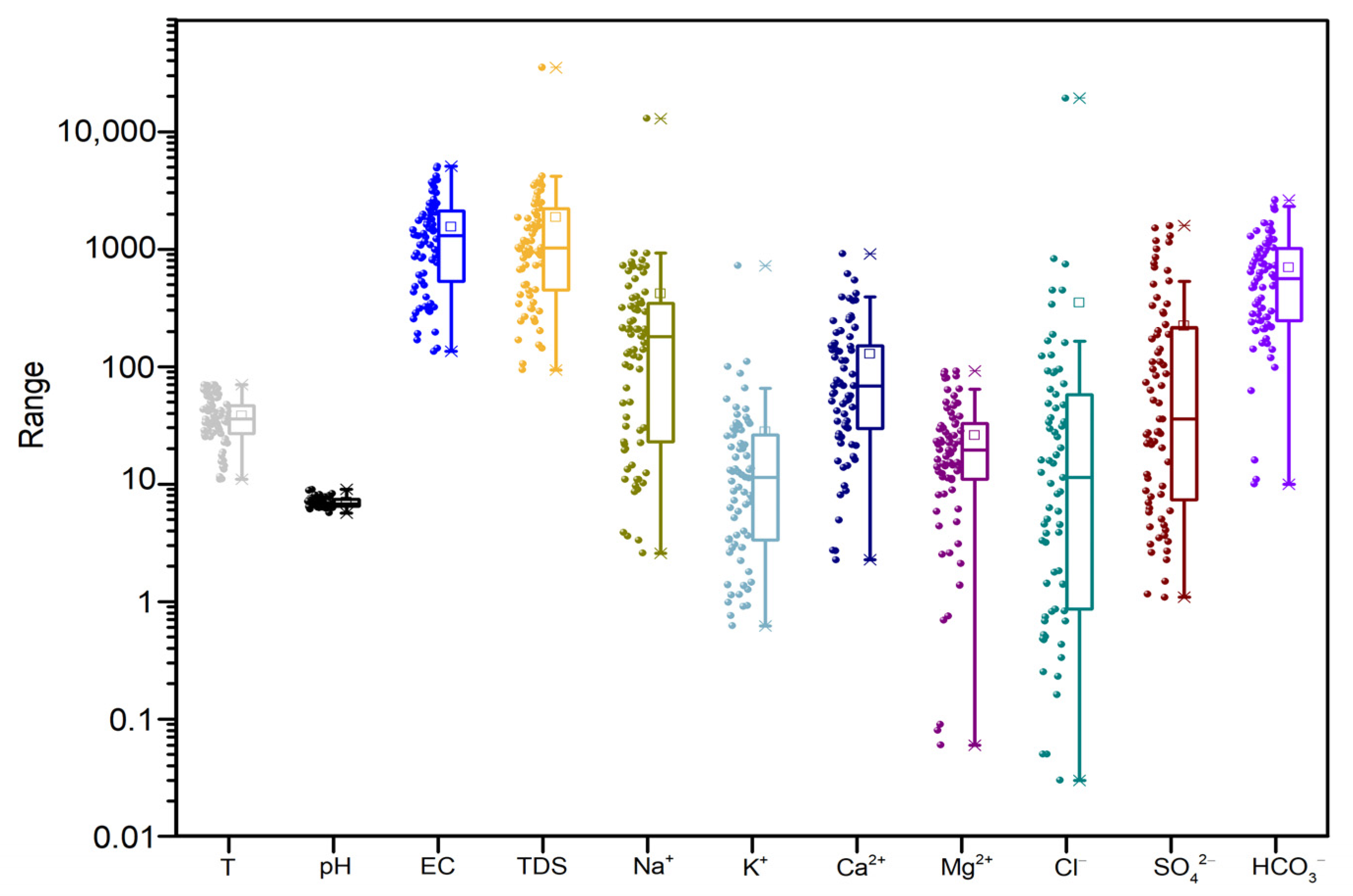
A box plot and Piper diagram were constructed to visually represent the physicochemical parameters and concentrations of major ions (K+, Na+, Ca2+, Mg2+, Cl, SO42−, and HCO3) in the springs, as shown in Figure 2 and Figure 3. In the Piper diagram, the main ions in the JZFZ and NJFZ are Na+, Ca2+, and HCO3. The main cations of spring water samples in the WQFZ and LCJFZ were Na+, while the main anions were HCO3 and SO42−. According to the Shchukarev classification, the spring water samples collected along the JZFZ and NJFZ predominantly fall into the Na-HCO3 and Ca-Mg-HCO3 types. Conversely, within the WQFZ and LCJFZ, the water demonstrates primarily Ca-Na-HCO3-SO4, Ca-Mg-SO4, and Na-Cl-SO4 types.
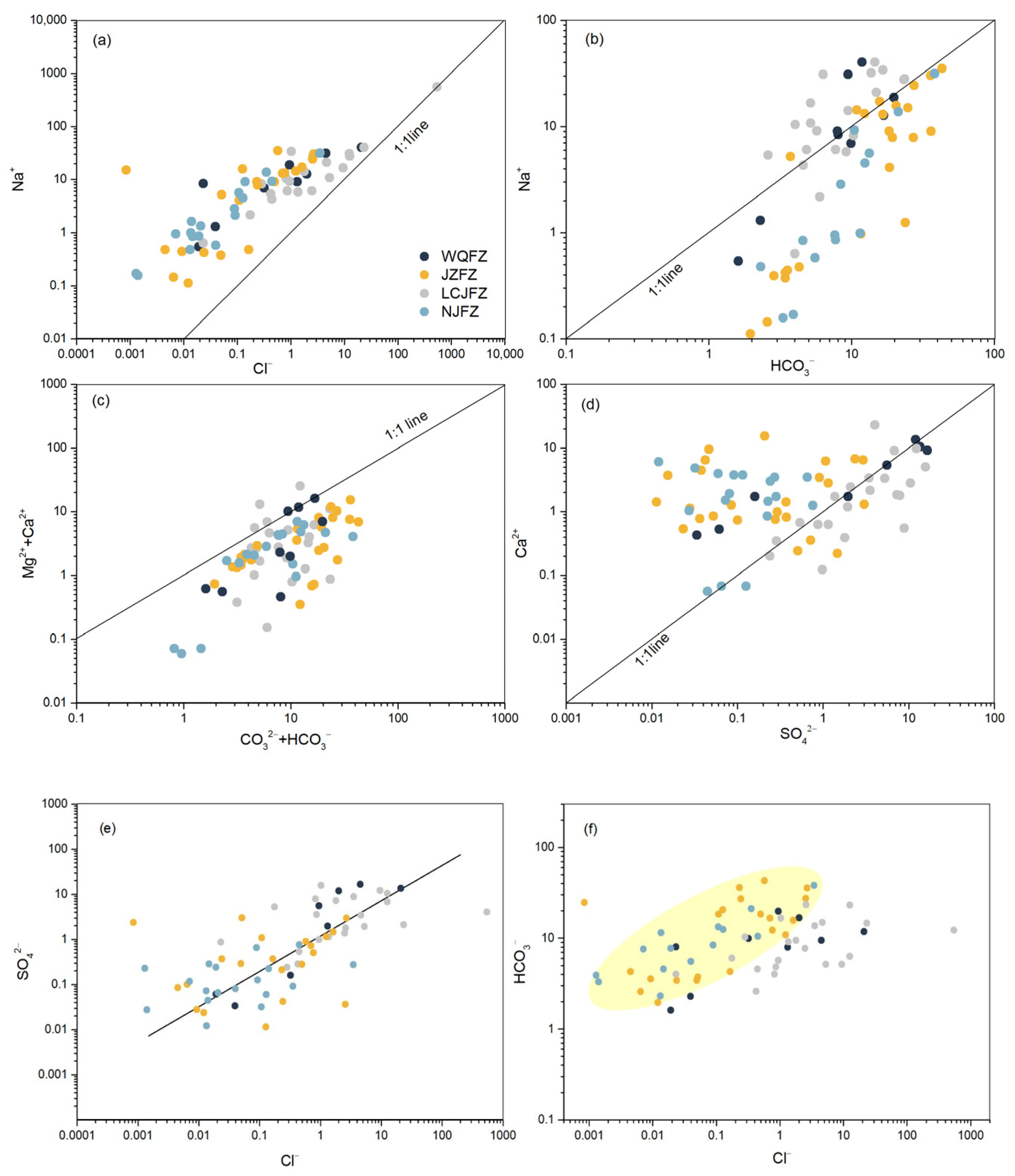
To elucidate the origin and evolution of major ions in thermal groundwater, an analysis of the relationships between key ions in the spring water was conducted, including Na+ vs. Cl; HCO3 vs. Na+; (Ca2+ + Mg2+) vs. (CO32−+ HCO3); SO42− vs. Ca2+; Cl vs. SO42−; and Cl vs. HCO3 (Figure 4). From Figure 4a, it can be seen that only sample (No. L41) aligns with the 1:1 Na/Cl line, indicating the influence of halite dissolution. Sample L41 is located on the LCJFZ, known for its abundant brine production. Along this fault zone, thermal spring water, dissolving Triassic salt-bearing formations, continuously emerges as brackish water rich in salts. Ratios such as γNa/γCl and γNa/γHCO3 (Figure 4a,b) reveal that water samples with elevated HCO3 and Na+ concentrations are predominantly distributed in the JZFZ and NJFZ. This implies the significant involvement of carbonate and silicate processes, considering reactions such as NaAlSi3O8 + 8H2O → Na+ + Al (OH)4 + 3H4SiO4 [67]. The study area, characterised by widely distributed carbonatite (Triassic marine limestone) and silicate rocks, facilitates abundant HCO3- through robust water–rock interactions. Cation exchange between Na-containing minerals and dissolved Ca+ further contributes to the high Na+ content in the water. Additionally, Figure 4f indicates that γHCO3/γCl ratios in spring water along the JZFZ and NJFZ exceed those in the WQFZ and LCJFZ, suggesting that elevated concentrations of HCO3- result not only from the dissolution of carbonate minerals but may also come from the introduction of deep-derived CO2 through conduit-like fault fractures. Some δ13CCO2 values suggest the possible addition of mantle-derived CO2 to the sampled geothermal fluids (see Section 5.3). From Figure 4c, it can be seen that the ratio of γCa + Mg/γCO3 + HCO3 in all water from the TRLCF falls below the 1:1 line, indicating the influence of Ca/Mg-rich minerals such as dolomite (Ca·Mg (CO3)2 + 2H2O + 2CO2 → Ca2+ + Mg2+ + 4HCO3). The ratios of γCa/γSO4 can be roughly divided into two groups (Figure 4d), with one group from LCJFZ and WQFZ falling in and below the 1:1 line, suggesting gypsum dissolution as a significant source of Ca2+ and SO42− (CaSO4·2H2O → Ca2+ + SO42− + 2H2O). The dissolution of gypsum and anhydrite occurs commonly in the clastic sedimentary sandy conglomerates of the Lanping basin of the study area [68]. SO42− in spring water samples is related to the gypsum salt layer. The second group, from JZFZ and NJFZ, mostly falls above the 1:1 ratio line, indicating that gypsum dissolution is not the primary source of Ca2+ and SO42−. Granite, schist, sandstone, and limestone are well developed in the study area, and some springs may percolate into deeper Carboniferous carbonates. The interactions of groundwater with granite and carbonate formations likely contribute to the observed chemical characteristics of the spring water (N63–N69). Finally, the positive correlation between SO42− and Cl, as indicated in Figure 4e, suggests the dilution of thermal water by shallow cold water. This correlation aligns with the lower SO42− content in spring water along the JZFZ and NJFZ, contrasting with the WQFZ and LCJFZ, as is consistently shown in Figure 3.
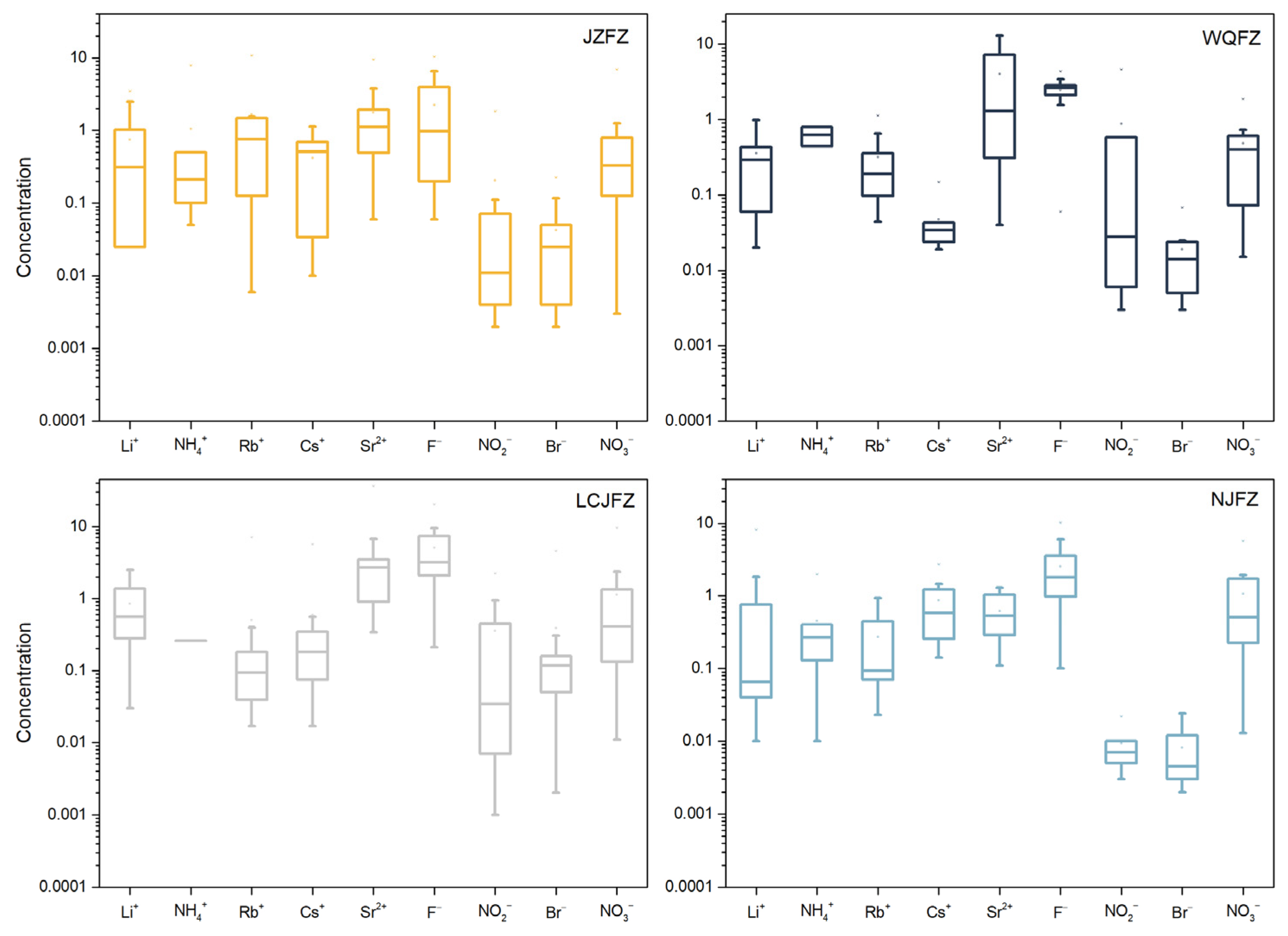
To analyse the differences in the contents of Li+, NH4+, Rb+, Cs+, Sr2+, F, NO2, Br, and NO3 ions in thermal springs along JZFZ, WQFZ, LCJFZ, and NJFZ, a box plot was created, as shown in Figure 5. Ammonium is an important parameter of geothermal fluids and high NH4+ value indicates that there may be input from anthropogenic sources. The presence of NH4+, NO3, and NO2 can indicate the degree of groundwater contamination by surface water. Typically, deep groundwater has little to no NO3 present, whereas the presence of NH4+ and NO2 indicates that the groundwater may have recently been contaminated. The content of NO3, NH4+, and NO2 near the WQFZ had slightly higher values than those of the JZFZ, LCJFZ, and NJFZ. This observation suggests that the circulation depth of springs in the WQFZ region is relatively shallow, making them more susceptible to mixing with shallow groundwater. Li+ is a highly active element that is easily enriched in thermal spring water and is the signature element of deep liquid upwelling [69]. Li+ is relatively enriched in samples J14, J21, L41, L42, L43, N64, N71, N72, and N73, where volcanic rocks were found in certain amounts. Rb+ and Cs+ are typical postmagmatic components and indicate the involvement of magmatic sources. The Rb+ and Cs+ concentrations of samples J12, J14, J15, J16, J18, L41, N68, and N71 are significantly higher than those of other samples and are closely related to the distribution of volcanic rocks. The study area features the development of carbonate and clastic components, with the majority of springs exhibiting weak alkalinity. Due to the propensity for F and Sr2+ to accumulate in weak alkaline water, the concentrations of F and Sr2+ in the water bodies of the study region are relatively high [70,71].

5.2. Reservoir Temperature and Circulation Depth

Traditionally, cation ratio geothermometers—such as Na-K, Na-K-Ca, and K-Mg geothermometers—and SiO2 geothermometers are employed to estimate geothermal reservoir temperatures. The water–rock equilibrium state of thermal water is often visualised using the Na-K-Mg triangular diagram, categorizing spring waters into three types: fully equilibrated waters, partially equilibrated waters, and immature waters [72]. Only fully equilibrated waters can be reliably used with cation geothermometers to estimate geothermal reservoir temperatures. In Figure 6, most data points are situated in the area representing immature water, which is evident in the thermal springs plot. Sample No. L41 is positioned in the partially equilibrated area of the triangular diagram, indicating that the wall rock has not achieved equilibrium, likely due to the influx of a significant quantity of cold water (shallow groundwater). This suggests that cation geothermometers may not be suitable for calculating reservoir temperatures in the study area.
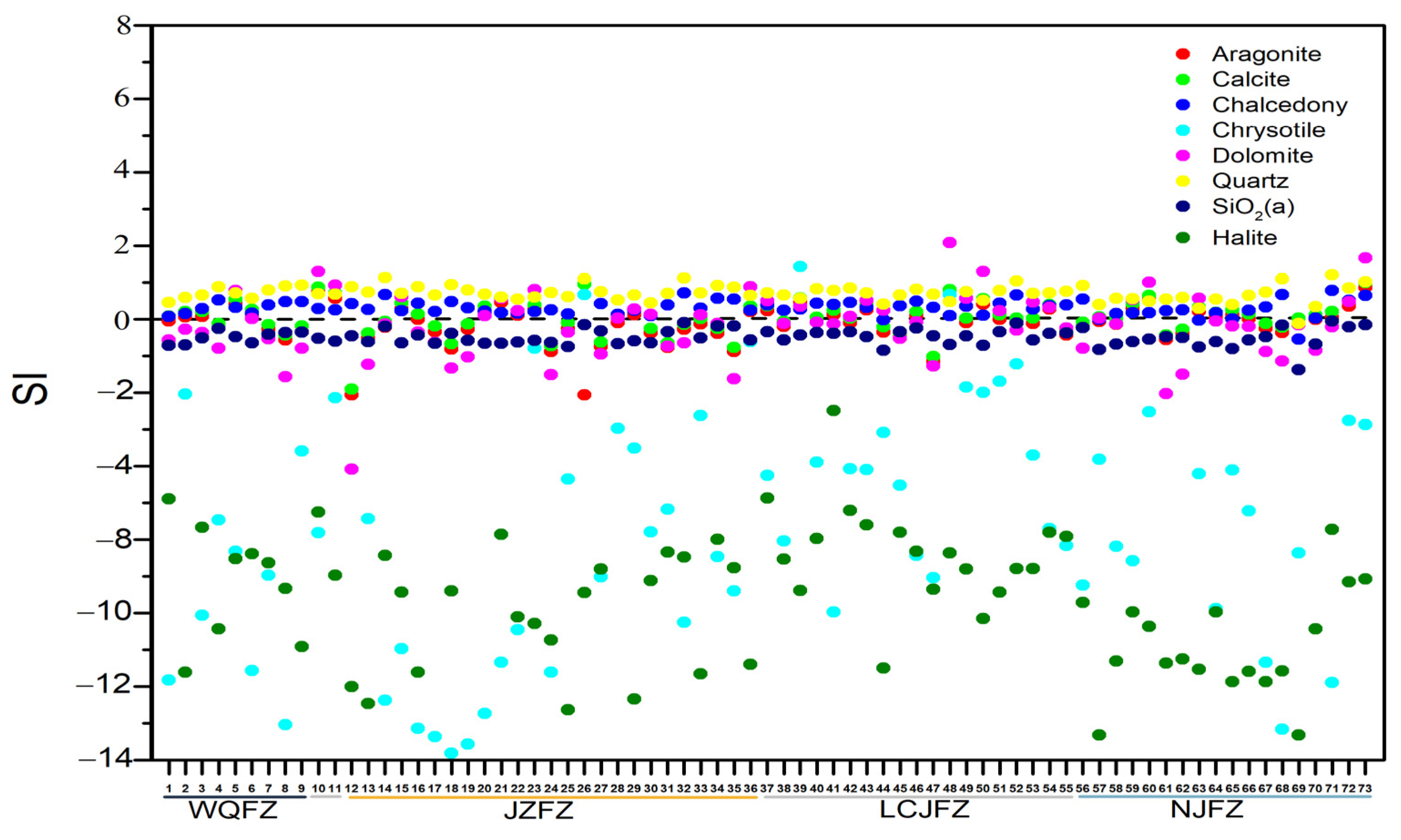
When analysing the geothermal spring water samples, mineral saturation indices (SI) were calculated using the PHREEQC software; the results are visually represented in Figure 7. The SI variations for chrysotiles and halites in each spring water sample are notably diverse. The majority of spring water samples predominantly exhibit an unsaturated state (SI < 0) concerning SiO2 (a), suggesting that amorphous silica does not primarily control the SiO2 content in the solution. In contrast, chalcedony and quartz approach equilibrium (SI ≈ 0), with chalcedony exhibiting closer proximity to the saturation line than quartz. Fluctuations above and below the nearby equilibrium line for dolomite, aragonite, and calcite indicate variations in the characteristics of the surrounding rock. This phenomenon may signify higher mineral content and extended residence time in the aquifer system [73], as indicated by saturation. Conversely, an unsaturated state suggests that minerals are relatively soluble or have insufficient reaction time with thermal water. These nuanced variations highlight the intricate and complex nature of mineral–water interactions within the studied geothermal springs.
SiO2, due to its higher stability in comparison to other minerals, serves as an indicator of thermal reservoir temperature for immature water. Considering this, SiO2 geothermometers [74] were selected based on Equations (1) and (2). However, it is important to note that, when the temperature is below 110 °C, chalcedony typically controls the SiO2 content in the solution rather than quartz [75]. Therefore, when the reservoir temperature calculated using Equation (1) is below 110 °C, it is recalculated using Equation (2). Additionally, springs with water temperatures below 20 °C are not included in the calculation.
θ q u a r t z ° C = 1309 5.19 log S i O 2 273.15
θ c h a l c e d o n y ° C = 1032 4.69 log S i O 2 273.15
In Equations (1) and (2), SiO2 represents the SiO2 concentration in the thermal spring samples, and the corresponding results are presented in Table 1. The temperatures calculated using SiO2 geothermometers fall within the range of 25.6 °C to 157.4 °C. The circulation depth is estimated by utilising the local geothermal gradient and the reservoir temperature of the thermal spring water, as described in Equation (3).
H = ( T T 0 ) / q + h 0
where H is the circulation depth (km), h0 is the depth of the thermostatic zone (km), T is the reservoir temperature ( ° C ), T0 is the temperature of the constant temperature zone ( ° C ), and q is the geothermal gradient ( ° C / k m ). Considering previous studies on groundwater in some areas of Yunnan Province, a geothermal gradient q of 20 ° C / k m , an annual average temperature T0 of 15.8 ° C , and a constant temperature zone depth h0 of 30 m were assumed [76]. Therefore, the final circulation depth of the 73 thermal springs ranged from 0.5 to 7.1 km, while the average circulation depth was 3.8 km (Table 1).

5.3. Characteristics of Geothermal Gas

5.3.1. Origin of He

Helium has two stable isotopes with mass numbers 3 and 4. 3He mainly escapes from the mantle. A large portion of 3He is primordial He, which was trapped in the solid earth at the time of accretion [77]. A small portion of 3He is produced by the nuclear reaction of 6 Li (n, α) 3H (−1 β) 3He. Decaying crustal U and Th predominantly produce 4He [78]. An R/Ra versus 4He/20Ne diagram was used to identify the origin of the He in the TRLCZ (Figure 8). The He isotopic compositions of the air, MORB, and crust are already well established [79]. By assuming R/Ra and 4He/20Ne ratios of 0.02 and 1000, 1 and 0.318, and 8 and 1000 for the crust, air, and MORB-type mantle, respectively, the mixing proportions were estimated using Sano and Wakita’s [79] equations. The boundary lines of this model are calculated using the following mass balance equations:
(3He/4He)Obs = (3He/4He)Air × A + (3He/4He)Mantle × M + (3He/4He)Crust × C
1/(4He/20Ne)Obs = A/(4He/20Ne)air + M/(4He/20Ne)Mantle + C/(4He/20Ne)Crust
A + M + C = 1
The He isotopic compositions of atmospheric, crustal, and mantle have their own typical characteristics. The 3He/4He ratio of air (1.4 × 10⁻⁶) is defined as 1 Ra. The MORB mantle source has a 3He/4He ratio of ~8 Ra [80], whereas the production of radiogenic 4He due to the decay of radioactive U and Th in the crust leads to lower 3He/4He ratios of 0.005 Ra to 0.02 Ra [81]. To conduct a comprehensive comparison, additional data on helium (He) and carbon (C) isotopes from thermal springs near the TRLCZ were needed. To address this, we incorporated Zhou’s results (Table S3) into our analysis [82]. As illustrated in Figure 8, all data points from the samples fell on the binary mixing lines between the atmospheric and crustal components. However, 12 gas samples were excluded from consideration due to relatively high air contamination during sampling, exceeding 1%. It is worth noting that all the isotopic ratios of helium (Rc/Ra) were found to be less than 1 Ra, indicating that, along the TRLCZ, the helium isotope ratios have experienced significant dilution from crustal radiogenic 4He. The Rc/Ra ratios of all free gas samples ranged from 0.01 Ra to 0.52 Ra (Table S3), while the Rc/Ra ratios of quite a few samples were higher at >0.1 Ra. The Rc/Ra ratio (>0.1 Ra) can be taken as evidence for the presence of mantle-derived fluids entrained by the hydrologic system [83,84]. The contributions of mantle-derived He were calculated using Equations (4)–(6). Except for a higher addition of mantle-derived He (6.3%) from the JZFZ, for most of the other samples, the mantle-derived He proportions were lower than 5%. Multiple mechanisms can generate 3He, including the decay of 6Li or tritium 3H, as well as contributions from the mantle [85]. However, the decay of 6Li alone cannot account for the relatively high 3He/4He ratios observed. This is because the crustal production ratio of 3He/4He is estimated to be 10−8 (approximately 0.005–0.02 Ra) [86]. Furthermore, the contribution of tritiogenic helium to the total 3He in thermal spring gases is unlikely to be significant due to the low natural tritium background levels in precipitation (usually ≤5 TU) [87]. Additionally, there are no active Cenozoic volcanoes in the study area. Therefore, the relatively high 3He/4He values observed, along with the approximately 2%–5% contribution of mantle-derived helium in the research area, can be attributed to the transport of mantle helium to the surface through faults and fractures.
The detection of mantle-derived helium on the Earth’s surface requires both a mechanism to extract helium from the mantle and a pathway for its ascent [88]. Geophysical investigations, such as seismic tomography, have provided insights into the origin and migration of mantle volatiles. Studies by Crossey et al. [89], Horiguchi et al. [90], and Zhang et al. [91] revealed that regions with higher emissions of mantle-derived helium correspond to negative anomaly bodies, indicating that mantle volatiles originate from the upwelling asthenosphere. Previous studies have shown that the upper mantle of the southeastern Tibetan Plateau has a series of low shear-wave velocity anomalies beneath the JZFZ, as well as the southern segments of the LCJFZ and NJFZ [40,92]. Within the TRLCF, major faults can serve as conduits for the ascent of mantle volatiles. Furthermore, the clockwise movement of the Sichuan–Yunnan rhombic block around the eastern Himalayan syntaxis (EHS) suggests a coupling of deformations between the upper and lower crusts [93]. Geophysical observations (e.g., ambient noise tomography and magnetotelluric imaging) and geodynamic modelling suggest that the existence of middle-to-lower crustal flow could contribute to material escape toward the southeast [39,40,41,42]. The TRLCZ is located in the frontier zone where materials from the Tibetan Plateau flow southeastward. Recent seismic investigations have identified a low-velocity anomaly indicative of partial melt and flow in the research area at depths ranging from 20 to 30 km [43,94]. The presence of partial melting facilitates the release of 3He, since solid-state processes are insufficiently rapid for the extraction of noble gases [83].

5.3.2. Origin of CO2

The mantle-derived δ13CCO2 concentration ranges from −8‰ to −4‰ [95], and that from limestone thermometamorphism is ±2‰ [96]. Mantle-derived CO2 can exhibit strong variation in its isotopic composition (δ13CCO2 = 0‰ to −8‰), mainly due to the variable mixing of mantle-derived CO2 and crustal contributions [97,98]. Organic CO2 is typically characterised by a strongly negative carbon isotopic signature from −70 to −25‰ [99]. A CO2/3He-δ13C mixing model based on the methodology proposed by Sano and Marty [100], and a plot of δ13C (‰) vs. CO2, were employed to improve the identification of mixing processes. Most samples generally fell on a binary mixing line between the mantle and limestone endmembers (Figure 9a), suggesting the possible addition of mantle-derived CO2 to the sampled geothermal fluids. As shown in Figure 9b, the increase in CO2 content was accompanied by 13C isotope enrichment. Further, carbonate-rich rocks are widespread in this area. Crustal limestone could serve as the primary source for these CO2-rich samples, exhibiting high δ13CCO2 values, ranging from −1.6‰ to −7.2‰, at the top right of Figure 9b. Considering our previous discussion suggesting that the higher 3He/4He values in the research area might be the result of minor additions of mantle helium, it is reasonable to consider that trace amounts of mantle CO2 could also contribute to the geothermal volatiles in the TRLCZ.

5.4. Spatial Distribution of Hydrogeochemical Characteristics in TRLCF

The kriging spatial interpolation method in Surfer13.0 (Surface Mapping System, Golden Software, Inc, Golden, CO, USA) was used to draw contour maps of the gas contents (H2, CO2, He, and mantle He %) of sampling sites in order to expound the spatial discrepancies in thermal waters from the study area (Figure 10). According to Figure 10, the geothermal system in the TRLCF is significantly influenced by the underlying structural characteristics. This influence is evident as the majority of thermal springs are located along four active NS-trending normal and strike-slip crustal faults. The presence of faults and fractures provides pathways for pressured fluids and gases to migrate towards the surface. Figure 11 demonstrates a positive correlation between the depth of circulation and fault activity. In our research area, the JZFZ exhibits a considerably higher average slip rate (~4 mm/a or 5–7 mm/a) compared to the WQFZ (0.89 mm/a or 1.8–2.4 mm/a) [30,35,36,37,38,53]. The average circulation depth of thermal spring water along the JZFZ is 4 km, which is relatively deep. Conversely, the northern segment of the WQFZ has the shallowest circulation depth of thermal spring water (ranging from 1 to 3 km, excluding a maximum value of 6 km). The fracture junctions of the LCJFZ with the JZFZ exhibit higher circulation depths of thermal spring water, ranging from 4 to 7 km. The circulation depth of thermal spring water along the southern segments of the NJFZ surpasses that of the northern segments, with depths ranging from 5 to 7 km and 2 to 3 km, respectively. The strike-slip rates of the LCJFZ and NJFZ are approximately ~3 mm/a [31,32,33,34]. Additionally, based on earthquake observation since 2009, it is evident that the frequency of Ms ≥ 4 earthquakes is notably higher in active fault zones (JZFZ), where thermal springs have deeper groundwater circulation (as shown in Figure 11). In the structural junction areas, such as the fracture junctions of the LCJFZ with the JZFZ, where the fluid circulation depth is relatively deep, there is a higher propensity for seismic activity, as illustrated in Figure 10d and Figure 11. This observation suggests a close relationship between underground fluids and the seismogenic process in the study area. Deeper circulation depths correspond to more intense water–rock reactions. The seepage of groundwater into the deeper layers increases pore fluid pressure, intensifies the interactions between water and rock, weakens fault zones, and enhances earthquake susceptibility [101,102,103]. Therefore, it is crucial to further investigate seismic activity in areas with deep geothermal water circulation.
Figure 10 shows the spatial distribution of the H2 concentration, the CO2 concentration, the He concentration, and mantle He proportions in gases emitted from the four faults of the TRLCF. A comparison of the spatial distribution of hydrogeochemical characteristics (H2, CO2, He, and mantle He %) and the circulation depth of thermal springs in the different faults shows that there is a positive correlation between the emission of He that has traversed the crust and the circulation depth (higher values of concentrations of He and mantle He% always occur near the sampling points with deeper circulation depths; Figure 10c,d). However, no such correlation existed between the emission of H2 and CO2. A high concentration region of H2 in the southern segment of the LCJFZ roughly corresponds to a higher circulation depth (Figure 10a). However, no such consistent pattern is observed for the JZFZ, WQFZ, and NJFZ. The elevated concentration of H2 in the fracture zones is consistent with the idea that H2 is generated by radical reactions between H2O and Si-O or Si- radicals, which appear on the fresh surfaces of fractured rocks [104]. The more active the fracture zone is, the more developed the fresh rupture surface of silicate rock in the fracture zone, and the more H2 is produced [105]. Interestingly, the recent 2023 Baoshan M 5.2 earthquake occurred in the range of an anomalous area with high concentrations of H2 release (Figure 10a). This implies that, in the monitoring of earthquake precursors, the measurement of hydrogen gas content could potentially serve as a favourable geochemical surface observation method.
The concentration of carbon dioxide (CO2) is found to be high in the WQFZ, which is characterised by a shallow circulation depth and low fault activity (Figure 10b). This observation suggests that the elevated CO2 levels in the WQFZ originate from the surface, as there are no available higher-permeability pathways for fluids to migrate from deeper regions. One potential explanation for the heightened concentration of CO2 in the WQFZ is the prevalence of carbonate rocks, distinguishing it from other fault zones. Another possible explanation for the high CO2 concentration in low-activity fault zones is the occurrence of chemical reactions, as documented in previous studies, such as that by Garrels and Christ [106] (7–10). These reactions play a role in diminishing CO2 levels within areas characterised by high fault activity. Notably, the chemical reactions proceed at a faster pace in zones with heightened fault activity as compared to those with lower fault activity. This disparity in reaction rates can be attributed to the larger total surface area of minerals present in high fault activity zones, providing more opportunities for these reactions to take place.
2KMg3AlSi3O10(OH)2 [biotite] + 14CO2 + 7H2O → Al2Si2O5(OH)4 [kaolinite] + 6Mg2+ + 2K+ + 4SiO2 + 14HCO3
2KAlSi3O8 [orthoclase] + 2CO2 + 3H2O → Al2Si2O5(OH)4 [kaolinite] + 2K+ + 4SiO2 +2HCO3
1.61Na0.62Ca0.38Al1.38Si2.62O8 [plagioclase] + 2.20CO2 + 3.30H2O → 1.1Al2Si2O5(OH)4 [kaoline] + 1.0Na+ + 0.61Ca2+ + 1.99SiO2 + 2.20HCO3
1.61Na0.62Ca0.38Al1.38Si2.62O8 [plagioclase] + 1.90CO2 + 1.90H2O → 0.95 Ca0.17Al2.33Si3.67O10(OH)2 [montmorillonite] + Na+ + 0.45Ca2+ + 0.72SiO2 + 1.90HCO3
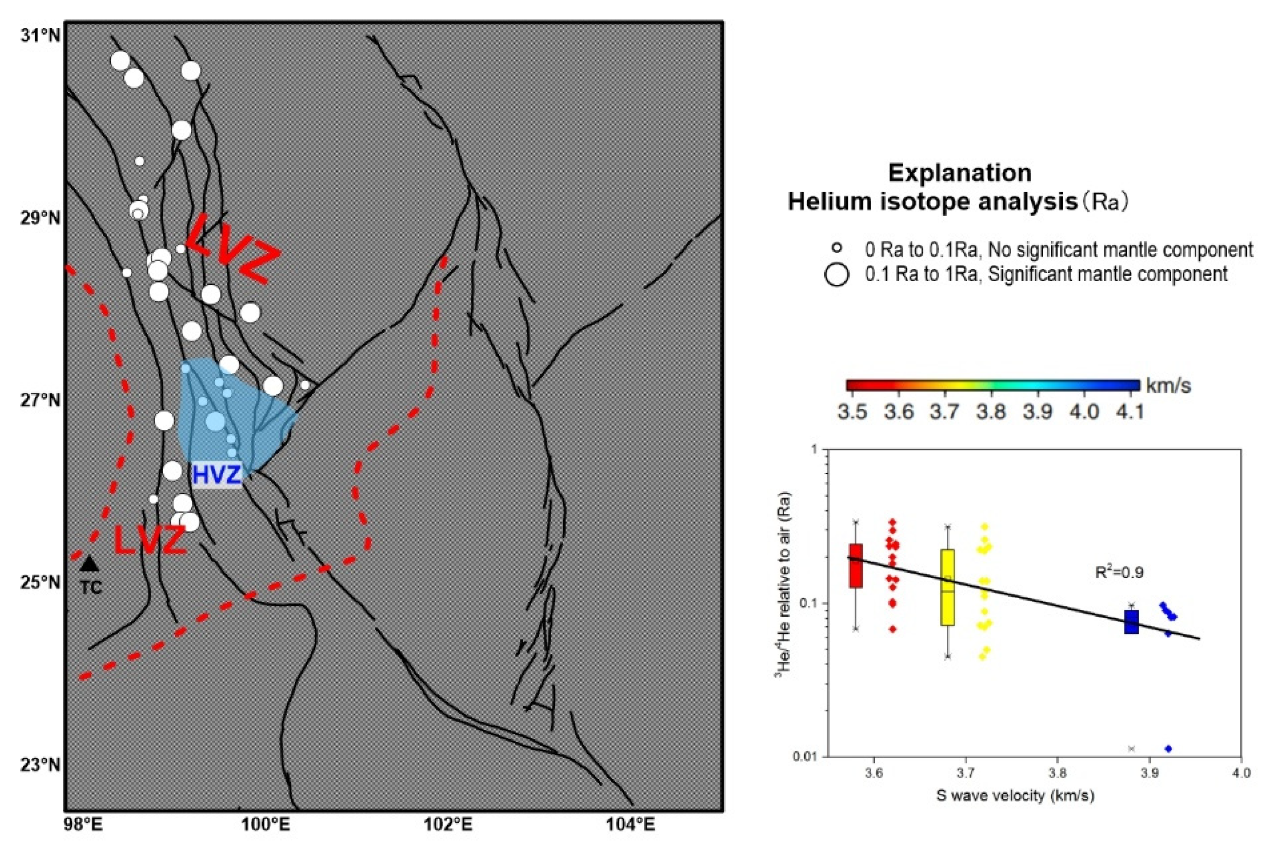
Although helium (He) was a minor component of the gases, it increased in quantity at fracture junctions of the JZFZ (Figure 10c). The contributions of mantle helium (He) from the JZFZ, the southern segment of the NJFZ, and the LCJFZ were estimated to be in the range of 2–5% (Figure 10d). Several geophysical investigations (seismic tomography) revealed that higher emissions of mantle-derived helium are found above low-velocity bodies, implying that mantle volatiles originate from the upwelling asthenosphere [89,90,91]. Previous studies have noted the presence of a series of low shear-wave velocity anomalies in the upper mantle beneath the JZFZ, as well as the southern segments of the LCJFZ and NJFZ (situated between 24° and 26°N) in the southeastern Tibetan Plateau (see Figure 12) [40,92]. Within the JZFZ, there are large-scale low-resistivity zones in the middle and upper crust, which may be related to partial melting and heat flow [107,108]. The spatial distribution of mantle He contribution (>2%) along the southern segments of the LCJFZ and NJFZ (positioned between 24° and 26°N) is approximately 70–80 km away from the Tengchong volcanic field (TC; refer to Figure 12). The Tengchong volcanic field (TC) is representative of a bottom boundary zone with upwelling in the asthenosphere. Its 3He/4He ratio consistently surpasses 1 Ra, reaching a maximum of 6 Ra, and the percentage of mantle-derived helium release exceeds 60% [109]. This observation implies a discernible influence of the Tengchong volcanic field on the release of mantle-derived helium along the southern segments of the LCJFZ and NJFZ. Conversely, the blue domain in Figure 12 represents HVZs (high-velocity zones) beneath the WQFZ, implying that the tectonic activity in this region may be blocked by stiffer rocks. Additionally, Figure 12 provides visual evidence that regions characterised by higher 3He/4He ratios (Rc/Ra) in surface waters align with the areas where the low-velocity anomaly zone (LVZ) is observed. This correlation strongly suggests that these regions are closely linked to the upwelling of hot material within the upper mantle. This conclusion is further supported by a correlation (R2 = 0.9) between Ra and the mantle velocity in the TRLCF (Figure 12, inset). Areas characterised by high conductivity and low velocity within a fault zone are typically interpreted as zones of fault disruption resulting from impact sliding or shearing along the fault. These zones are often associated with the presence of deep-seated magma and/or metamorphic fluids.
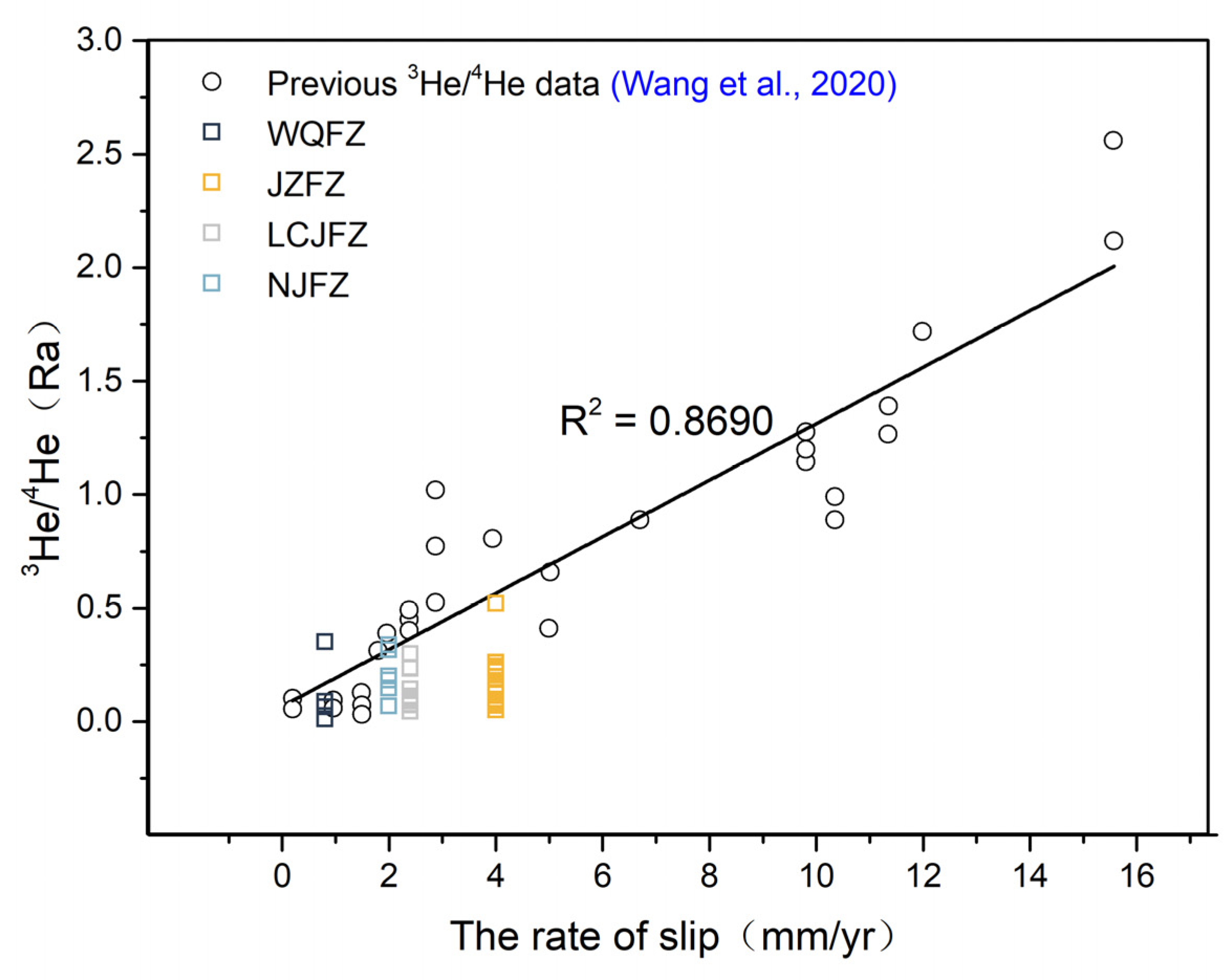
The transport of He volatiles through faults and fractures whose permeability is controlled by fault activity, and the correlation of 3He/4He ratios with time-averaged fault slip rates, suggest that higher slip rates are associated with more permeable vents [91]. Research conducted by Wang et al. [110] has indicated that there is a positive correlation between the emission of He that has traversed the crust and the fault slip rate (Figure 13). In our research area, the 3He/4He ratios in thermal spring gases along the JZFZ, WQFZ, LCJFZ, and NJFZ were 0.10–0.52 Ra, 0.01–0.35 Ra, 0.04–0.30 Ra, and 0.10–0.33 Ra, respectively. The 3He/4He values (Rc/Ra) along the JZFZ exhibit the highest ratios among the four faults studied, while the WQFZ has the lowest 3He/4He values (Rc/Ra) compared to the other three faults. By utilising the linear trend observed in the graph, it is possible to estimate the strike-slip rates based on the 3He/4He ratios (Rc/Ra). The calculated average slip rate for the JZFZ is notably higher at approximately 4 mm/a, whereas the WQFZ has a lower average slip rate of around 1 mm/a. The strike-slip rates of the LCJFZ and NJFZ fall within the range of 2–3 mm/a. These calculated strike-slip rates are consistent with some prior geological findings (see Section 2) [30,31,32,33,34,35,36,37,38], further supporting the notion that the release of mantle-derived helium in gas bubbling from thermal springs along active faults serves as an indicator of fault activity. The elevated helium isotope values of thermal spring gas in this region suggest that there has been a significant upwelling of deep fluids [84], which could have the effect of weakening the fracture [111,112]. Moreover, it increases the pore pressure within the fracture, which is a key factor that encourages the incidence and breeding of earthquakes [113]. By studying the distribution characteristics of seismic activity (M ≥ 5.0) in the TRLCZ (Figure 10d), it can be seen that the regions with seismic activity are often accompanied by mantle-derived He release, indicating that mantle fluids play a critical role in the formation and occurrence of earthquakes in this region. Therefore, thermal springs with mantle-derived characteristics can be used as observation objects for earthquake monitoring and prediction, and mantle He contributions, gas component content, and circulation depth can be employed as parameters of geochemical observations.

5.5. Fluid Circulation Model

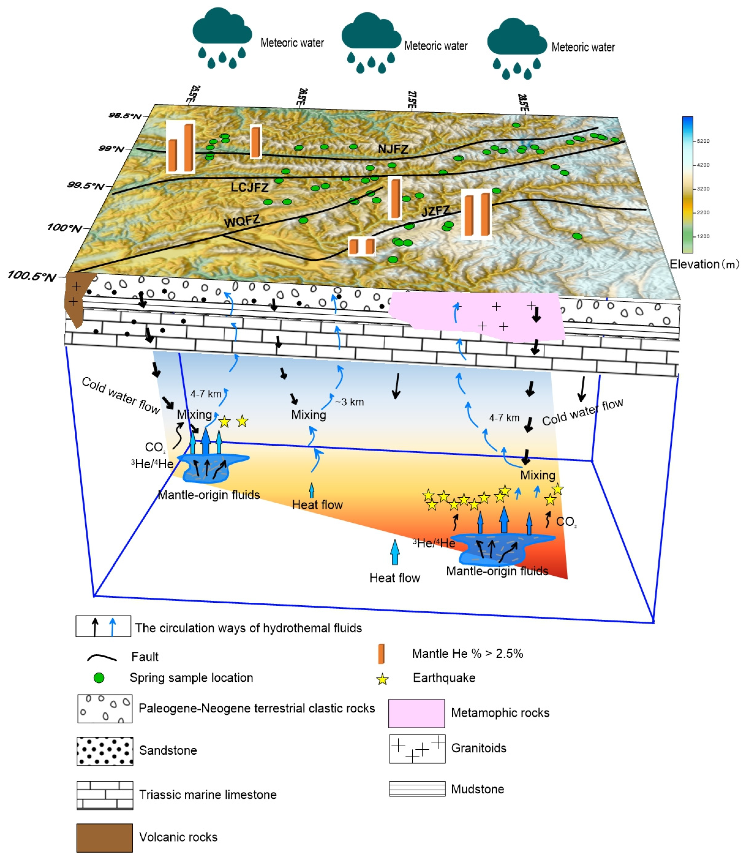
Figure 14 illustrates the fluid circulation model governing groundwater migration and deep mass transfer in the TRLCZ. Meteoric water infiltrates fractured metamorphic and clastic rocks within high mountainous regions to be heated as thermal water. The prevalence of a thick red mudstone layer, serving as the cover for the geothermal system, contributes to poor permeability, fostering heat accumulation during groundwater movement [114]. The existence of prevalent NW- and NE-trending fault systems, coupled with intense seismic activities, fractures the outcropped rocks in these regions. Consequently, meteoric water easily percolates in the depths through structurally weak zones. As discussed in Section 5.1, the chemo-diversity of the studied geothermal water is constrained by the characteristics of host rocks and the extent of water–rock interactions. Their evolution appears to be controlled by specific tectonic units. For instance, spring water samples collected along the JZFZ have Na-HCO3 and Ca-Mg-HCO3 compositions, respectively. In contrast, within the WQFZ (located in the Lanping Basin), the water changes to the Ca-Na-HCO3-SO4 and Na-SO4 types. This characteristic shift is indicative of increased interaction with carbonate-contained aquifers during the water’s flow from northern mountain regions to southern basins. This characteristic change is also associated with the diverse lithology of aquifers, with the JZFZ predominantly composed of resistant high-grade metamorphic rocks and the WQFZ containing limestone, red-coloured terrestrial siliciclastic rocks, gypsum, and halite.
Quartz geothermometers indicate some higher reservoir temperatures (>130 °C) located in the JZFZ and the southern segments of the NJFZ. The JZFZ and NJFZ are active large-scale fault zone faults, and low-velocity zones within these zones [43,94], linked to partial melt in the upper-middle crust, can serve as deep water circulation and heat sources. Consequently, elevated temperatures enhance water–rock interaction, as observed in some springs in these areas. Thermal springs in other regions exhibit lower reservoir temperatures, mainly below 90 °C, indicating shallower depths, particularly notable in the WQFZ situated in the Lanping Basin.
The flow direction of thermal water in the TRLCZ is from the mountain region towards the interior of the basin. The thermal water obtains salinity from the diverse lithology of aquifers, subsequently rising and eventually mixing with shallow underground water. This process leads to the outcrops of warm springs. On another note, fluids derived from the mantle, enriched with 3He/4He isotopes and CO2, ascend through the ductile crust due to the upwelling of thermal material in the upper mantle. The distribution of thermal springs in the TRLCF is significantly influenced by active fractures, acting as conduits for the ascent of mantle volatiles. The activity of these fractures also impacts gas emission activity [115]. Fluid migration towards the focal region of seismic incubation facilitates the lubrication of faults, activating existing structures in the shallower crust and contributing to the occurrence of strong earthquakes [116]. Consequently, in areas characterised by intense seismic activity, deep faults exhibiting high permeability, and the upward movement of mantle fluids from the depths, elevated releases of mantle-derived helium frequently manifest at the Earth’s surface.

6. Conclusions

In this paper, we investigated the hydrochemical characteristics and origins of He and C isotopes in 73 thermal springs located in the TRLCZ. The analysis of the relationships between major ions in thermal groundwater provides a comprehensive understanding of their origin and evolution. Dominant processes include carbonate and silicate interactions, with elevated HCO3 and Na+ concentrations observed in the JZFZ and NJFZ regions. The influence of Ca/Mg-rich minerals, such as dolomite, is apparent, impacting the cation composition of water. Additionally, the ratios of Ca/SO4 indicate the significant role of gypsum dissolution, particularly in the LCJFZ and WQFZ. The positive correlation between SO42− and Cl implies dilution by shallow cold water.
This study also investigated the depth of circulation in the fault zones, revealing variations among the different faults. The JZFZ faults exhibit a relatively deeper circulation depth, ranging from 4 to 7 km. On the other hand, the northern segment of the WQFZ has the shallowest circulation depth of thermal spring water (1–3 km). At fracture connections with the JZFZ, the LCJFZ revealed greater depths (4–7 km), and the circulation depth of thermal spring water along the southern segments of the NJFZ surpasses that of the northern segments, with depths ranging from 5 to 7 km and 2 to 3 km, respectively. Notably, a positive correlation exists between the depth of circulation and fault activity, suggesting that areas with deeper groundwater circulation are more prone to earthquakes. This finding emphasizes the importance of considering seismic activity in regions with deep geothermal water circulation for earthquake monitoring and prediction.
We analysed the Rc/Ra ratios of free gas samples, which ranged from 0.01 Ra to 0.52 Ra. Certain samples exhibited higher Rc/Ra ratios along with a greater contribution of mantle-derived helium, potentially indicating minor additions of mantle helium through faults and fractures to the surface. Crustal limestone was identified as the primary source of CO2-rich samples, exhibiting high δ13CCO2 values ranging from −1.6‰ to −7.2‰, while the presence of a trace amount of mantle CO2 cannot be ruled out as a contributing factor. The spatial distribution of the H2 concentration, CO2 concentration, He concentration, and mantle He proportions in gases showed that higher values of He and mantle He% concentrations always occur near the sampling points with deeper circulation depths. However, no similar correlation was observed in the emission of H2 and CO2. Additionally, most earthquakes of magnitude 5 or greater occurred near the region of high values of mantle source He release, highlighting the critical role of mantle fluids in the formation and occurrence of earthquakes in the region. Hence, the inclusion of mantle-derived He contributions and the variations in relevant gas components should be considered as parameters in geochemical observations. Furthermore, a fluid circulation model was developed to describe the process of fluid (water and gas) circulation migration and earthquake generation in the TRLCZ.
Overall, this study provides valuable insights into the hydrochemical characteristics, origins of He and C isotopes, and their relationships with tectonic structures and seismic activity in the TRLCZ. The findings contribute to a better understanding of the geology and geodynamics of the region, which can aid in earthquake monitoring and prediction efforts.

Supplementary Materials

The following supporting information can be downloaded at: https://www.mdpi.com/article/10.3390/min14030274/s1, Table S1: location, physicochemical parameters, and water type of thermal springs in the TRLCZ. Table S2: the chemical composition of hot spring waters in the TRLCZ. Table S3: characteristics of thermal spring gases from the TRLCZ.

Author Contributions

Q.L.: Conceptualisation, Formal Analysis, Methodology, Writing—Review and Editing, and Visualisation. Y.W.: Conceptualisation, Funding Acquisition, and Investigation. C.Z.: Methodology and Discussion. H.R.: Investigation. All authors have read and agreed to the published version of the manuscript.

Funding

This study was supported by the Fund of Key Research and Development Plan of Yunnan Province (202203AC100003) and the Open Research Project (No. KLIVE2023-03) from the Key Laboratory of Intraplate Volcanoes and Earthquakes (China University of Geosciences, Beijing), the Ministry of Education.

Data Availability Statement

Data are contained within the article and supplementary materials.

Acknowledgments

We are grateful to the anonymous reviewers and the editor for their useful comments and suggestions, which greatly improved the quality of this manuscript.

Conflicts of Interest

All authors agree that the author list is correct in its content and order. There are no conflicts of interest.

References

  1. Kennedy, B.M.; Kharaka, Y.K.; Evans, W.C.; Ellwood, A.; Depaolo, D.J.; Thordsen, J.; Ambats, G.; Mariner, R.H. Mantle fluids in the San Andreas fault system. Calif. Sci. 1997, 278, 1278–1281. [Google Scholar] [CrossRef]
  2. Italiano, F.; Bonfanti, P.; Pizzino, L.; Quattrocchi, F. Geochemistry of fluids discharged over the seismic area of the Southern Apennines (Calabria region, Southern Italy): Implications for Fluid-Fault relationships. Appl. Geochem. 2010, 25, 540–554. [Google Scholar] [CrossRef]
  3. Joseph, E.P.; Fournier, N.; Lindsay, J.M.; Fischer, T.P. Gas and water geochemistry of geothermal systems in Dominica, Lesser Antilles Island arc. J. Volcanol. Geoth. Res. 2011, 206, 1–14. [Google Scholar] [CrossRef]
  4. Wrage, J.; Tardani, D.; Reich, M.; Daniele, L.; Arancibia, G.; Cembrano, J.; P’erezMoreno, R. Geochemistry of thermal waters in the Southern Volcanic Zone, Chile- Implications for structural controls on geothermal fluid composition. Chem. Geol. 2017, 466, 545–561. [Google Scholar] [CrossRef]
  5. Hilton, D.R. Geochemistry—The leaking mantle. Science 2007, 318, 1389–1390. [Google Scholar] [CrossRef]
  6. Kennedy, B.M.; van Soest, M.C. Flow of Mantle Fluids Through the Ductile Lower Crust: Helium Isotope Trends. Science 2007, 318, 1433–1436. [Google Scholar] [CrossRef] [PubMed]
  7. Tian, J.; Pang, Z.; Liao, D.; Zhou, X. Fluid geochemistry and its implications on the role of deep faults in the genesis of high temperature systems in the eastern edge of the Qinghai Tibet Plateau. Appl. Geochem. 2021, 131, 105036. [Google Scholar] [CrossRef]
  8. Liu, W.; Zhang, M.; Chen, B.; Liu, Y.; Cao, C.; Xu, W.; Zheng, G.; Zhou, X.; Lang, Y.; Sano, Y.; et al. Hydrothermal He and CO2 degassing from a Y-shaped active fault system in eastern Tibetan Plateau with implications for seismogenic processes. J. Hydrol. 2023, 620, 129482. [Google Scholar] [CrossRef]
  9. Doğan, T.; Sumino, H.; Nagao, K.; Notsu, K.; Tuncer, M.K.; Çelik, C. Adjacent releases of mantle helium and soil CO2 from active faults: Observations from the Marmara region of the North Anatolian Fault zone, Turkey. Geochem. Geophys. Geosystems 2009, 10, Q11009. [Google Scholar] [CrossRef]
  10. Kulongoski, J.T.; Hilton, D.R.; Barry, P.H.; Esser, B.K.; Hillegonds, D.; Belitz, K. Volatile fluxes through the Big Bend section of the San Andreas Fault, California: Helium and carbon-dioxide systematics. Chem. Geol. 2013, 339, 92–102. [Google Scholar] [CrossRef]
  11. Zhao, D.P.; Mishra, O.P.; Sanda, R. Influence of fluids and magma on earthquakes: Seismological evidence. Phys. Earth Planet. Inter. 2002, 132, 249–267. [Google Scholar] [CrossRef]
  12. Lei, J.; Zhao, D. Structural heterogeneity of the Longmenshan fault zone and the mechanism of the 2008 Wenchuan earthquake (Ms 8.0). Geochem. Geophys. Geosyst. 2009, 10, Q10010. [Google Scholar] [CrossRef]
  13. Salah, M.K.; Zhao, D.P. 3-D seismic structure of Kii Peninsula in southwest Japan: Evidence for slab dehydration in the forearc. Tectonophysics 2003, 364, 191–213. [Google Scholar] [CrossRef]
  14. Wang, Z.; Zhao, D. Seismic evidence for the influence of fluids on the 2005 west off Fukuoka prefecture earthquake in southwest Japan. Phys. Earth Planet. Inter. 2006, 155, 313–324. [Google Scholar] [CrossRef]
  15. Xia, S.; Zhao, D.; Qiu, X. The 2007 Niigata earthquake: Effect of arc magma and fluids. Phys. Earth Planet. Inter. 2008, 166, 153–166. [Google Scholar] [CrossRef]
  16. El Hariri, M.; Abercrombie, R.E.; Rowe, C.A.; Rowe, C.A.; Nascimento, A.F.D. The role of fluids in triggering earthquakes: Observations from reservoir induced seismicity in Brazil. Geophys. J. Int. 2010, 181, 1566–1574. [Google Scholar] [CrossRef]
  17. Chiodini, G.; Caliro, S.; Cardellini, C. Geochemical evidence for and characterization of CO2 rich gas sources in the epicentral area of the Abruzzo 2009 earthquakes. Earth Planet. Sci. Lett. 2011, 304, 389–398. [Google Scholar] [CrossRef]
  18. Chiodini, G.; Cardellini, C.; Amato, A. Carbon dioxide Earth degassing and seismogenesis in central and southern Italy. Geophys. Res. Lett. 2004, 31, L07615. [Google Scholar] [CrossRef]
  19. Becken, M.; Ritter, O.; Bedrosian, P.A.; Weckmann, U. Correlation between deep fluids, tremor and creep along the central San Andreas fault. Nature 2011, 480, 87–90. [Google Scholar] [CrossRef]
  20. Koch, U.; Heinicke, J.; Vossberg, M. Hydrogeological effects of the latest Vogtland-NW Bohemian swarm quake period (August to December 2000). J. Geodyn. 2003, 35, 107–123. [Google Scholar] [CrossRef]
  21. Sano, Y.; Hara, T.; Takahata, N.; Kawagucci, S.; Honda, M.; Nishio, Y.; Tanikawa, W.; Hasegawa, A. Hattori, K. Helium anomalies suggest a fluid pathway from mantle to trench during the 2011 Tohoku-Oki earthquake. Nat. Commun. 2014, 5, 3084. [Google Scholar] [CrossRef]
  22. Sano, Y.; Takahata, N.; Kagoshima, T.; Shibata, T.; Onoue, T.; Zhao, D. Groundwater helium anomaly reflects strain change during the 2016 Kumamoto earthquake in Southwest Japan. Sci. Rep. 2016, 6, 37939. [Google Scholar] [CrossRef]
  23. Zhou, X.; Wang, W.; Chen, Z.; Yi, L.; Liu, L.; Xie, C.; Cui, Y.; Du, J.; Cheng, J.; Yang, L. Hot Spring Gas Geochemistry in Western Sichuan Province, China After the Wenchuan Ms 8.0 Earthquake. Terr. Atmos. Ocean. Sci. 2015, 26, 361–373. [Google Scholar] [CrossRef]
  24. Tapponnier, P. Oblique stepwise rise and growth of the Tibet Plateau. Science 2001, 294, 1671–1677. [Google Scholar] [CrossRef]
  25. Xu, Z.Q.; Yang, J.S.; Li, W.C.; Zeng, L.S.; Xu, C.P. Tectonic background of important metallogenic belts in the southern and southeastern Tibetan Plateau and ore prospecting. Acta Geol. Sin. 2012, 86, 1857–1868. (In Chinese) [Google Scholar]
  26. Tapponnier, P.; Peltzer, G.; Le Dain, A.Y.; Armijo, R.; Cobbold, P. Propagating extrusion tectonics in Asia: New insights from simple experiments with plasticine. Geology 1982, 10, 611–616. [Google Scholar] [CrossRef]
  27. Royden, L.H.; Burchfiel, B.C.; van der Hilst, R.D. The geological evolution of the Tibetan Plateau. Science 2008, 321, 1054–1058. [Google Scholar] [CrossRef]
  28. Li, Q.; Feng, S.; Bai, Z.; Gao, Y.; Gao, S.; Xiong, X.; Wang, X.; Lang, C.; Han, R.; Wu, Q.; et al. New research progress on crust-upper mantle structure in the southeastern margin of Qinghai-Tibet Plateau, China. J. Earth Sci. Environ. 2018, 40, 757–778. (In Chinese) [Google Scholar]
  29. Bai, M.K.; Chevalier, M.L.; Leloup, P.H.; Li, H.B.; Pan, J.W.; Replumaz, A.; Wang, S.G.; Li, K.Y.; Wu, Q.; Liu, F.C.; et al. Spatial slip rate distribution along the SE Xianshuihe fault, eastern Tibet, and earthquake hazard assessment. Tectonics 2021, 40, e2021TC006985. [Google Scholar] [CrossRef]
  30. Tang, R.C.; Han, W.B. Active Faults and Earthquakes in Sichuan; Seismological Pres: Beijing, China, 1993. (In Chinese) [Google Scholar]
  31. Wang, Y.Z.; Wang, E.N.; Shen, Z.K.; Wang, M.; Gan, W.J.; Meng, G.J.; Li, T.M.; Tao, W.; Yang, Y.L.; Cheng, J.; et al. GPS-constrained inversion of present-day slip rates along major faults of the Sichuan-Yunnan region, China. Sci. China, 2008; 51, 1267–1283. (In Chinese) [Google Scholar]
  32. Tang, F.T.; Song, J.; Cao, Z.Q.; Deng, Z.H.; Wang, M.; Xiao, G.R.; Chen, W.T. The movement characters of main faults around Eastern Himalayan Syntaxis revealed by the latest GPS data. Chin. J. Geophys. 2010, 53, 119–2128. (In Chinese) [Google Scholar]
  33. Song, J. Study on Current Movement Characteristics and Numerical Simulation of the Main Faults around Eastern Himalayan Syntaxis. Ph.D. Thesis, China Earthquake Administration, Beijing, China, 2011. (In Chinese). [Google Scholar]
  34. Wang, Y.Z.; Wang, M.; Shen, Z.K.; Shao, D.S.; Shi, F.Q. Present-day slip rates and potential earthquake risks along the Nujiang Fault. Seismol. Geol. 2015, 37, 374–383. (In Chinese) [Google Scholar]
  35. Wang, M.M.; Liu, S.; Shi, B.X.; Huang, C.C. Geological and geomorphic investigation in the epicenter area of the Shangrila- Derong MS5.9 earthquake in 2013. South China J. Seismol. 2017, 37, 80–88, (In Chinese with English Abstract). [Google Scholar]
  36. Chang, Z.F.; Zhang, Y.F.; Li, J.L.; Zang, Y.; Dai, B.Y. Recent active features of Weixi-Qiaohou fault and its relationship with the Honghe fault. J. Geomechanics 2016, 22, 517–530. (In Chinese) [Google Scholar]
  37. Chang, Z.F.; Zang, Y.; Chang, H. New Discovery of Holocene Activity along the Weixi-Qiaohou Fault in Southeastern Margin of the Tibetan Plateau and its Neotectonic Significance. Acta Geol. Sin. 2018, 92, 408–409. [Google Scholar]
  38. Li, L.; Liu, X.; Wan, Y.; Zheng, Z. Crustal deformation characteristics and recent movement changes of main fault zones in northwest Yunnan revealed by GPS and numerical simulation. Acta Geol. Sin. 2021, 95, 3205–3219. (In Chinese) [Google Scholar]
  39. Bai, D.; Unsworth, M.J.; Meju, M.A.; Ma, X.; Teng, J.; Kong, X.; Sun, Y.; Sun, J.; Wang, L.; Jiang, C.; et al. Crustal deformation of the eastern Tibetan Plateau revealed by magnetotelluric imaging. Nat. Geosci. 2010, 3, 358–362. [Google Scholar] [CrossRef]
  40. Wang, W.L.; Wu, J.P.; Fang, L.H.; Lai, G.J.; Yang, T.; Cai, Y. S wave velocity structure in southwest China from surface wave tomography and receiver functions. J. Geophys. Res.-Solid Earth 2014, 119, 1061–1078. [Google Scholar] [CrossRef]
  41. Bao, X.; Sun, X.; Xu, M.; Eaton, D.W.; Song, X.; Wang, L.; Ding, Z.; Mi, N.; Li, H.; Yu, D.; et al. Two crustal low-velocity channels beneath SE Tibet revealed by joint inversion of Rayleigh wave dispersion and receiver functions. Earth Planet Sci. Lett. 2015, 415, 16–24. [Google Scholar] [CrossRef]
  42. Li, M.; Zhang, S.; Wang, F.; Wu, T.; Qin, W. Crustal and upper-mantle structure of the southeastern Tibetan Plateau from joint analysis of surface wave dispersion and receiver functions. J. Asian Earth Sci. 2016, 117, 52–63. [Google Scholar] [CrossRef]
  43. Zhang, Z.Q.; Yao, H.J.; Yang, Y. Shear wave velocity structure of the crust and upper mantle in Southeastern Tibet and its geodynamic implications. Sci. China Earth Sci. 2020, 63, 1278–1293. (In Chinese) [Google Scholar] [CrossRef]
  44. Zhang, J.L.; Du, L.T.; Zhang, H.Q.; Shi, L.T. Discussion on the relationship between Wenchuan Mw 8 great earthquake and the low velocity and high conductive layer in midcrust. Northwestern Seismol. J. 2008, 30, 405–412. (In Chinese) [Google Scholar]
  45. Zhao, D.P. Seismological structure of subduction zones and its implications for arc magmatism and dynamics. Phys. Earth Planet. Inter. 2001, 127, 197–214. [Google Scholar] [CrossRef]
  46. Zhao, D.P.; Tani, H.; Mishra, O.P. Crustal heterogeneity in the 2000 western Tottori earthquake region: Effect of fluids from slab dehydration. Phys. Earth Planet. Inter. 2004, 145, 161–177. [Google Scholar] [CrossRef]
  47. Ren, Z.; Zhou, X.; Yang, M.; Wang, X.; Zheng, Y.; Li, X.; Shen, Y. Hydrochemical characteristics and formation of the Madeng hot spring in Yunnan, China. Geofluids 2018, 2018, 2368246. [Google Scholar]
  48. Wang, M.; Zhou, X.; Wang, J.; Li, X.; Liu, H. Occurrence, genesis and travertine deposition of the adong hot springs in northwestern Yunnan of china. Geothermics 2020, 87, 101851. [Google Scholar] [CrossRef]
  49. Xu, Z.J.; Yang, J.S.; Li, W.C.; Zeng, L.S.; Xu, C.P. Tectonic positioning of important metallogenic belts at southern and southeastern Tibet and ore prospecting. Acta Geol. Sin. 2012, 12, 1857–1868. [Google Scholar]
  50. Yang, S.W.; Zhang, X.P.; Mei, W.Z.; Yan, C.M.; Zhou, T.Q.; Wu, C.J. Characteristics of important faults and division of tectonic units in the west of Sanjiang orogenic belts, Yunnan province. Geol. Resourc. 2019, 28, 315–331. (In Chinese) [Google Scholar]
  51. Zhong, K.H.; Liu, Z.C.; Shu, L.S.; Li, F.Y.; Shi, Y.S. The Cenozoic strike-slip kinematics of the Lancangjiang Fault zone. Geol. Rev. 2004, 50, 1–8. (In Chinese) [Google Scholar]
  52. Deng, J.; Wang, Q.F.; Li, G.J.; Santosh, M. Cenozoic tectono-magmatic and metallogenic processes in the Sanjiang region, southwestern China. Earth Sci. Rev. 2014, 138, 268–299. [Google Scholar] [CrossRef]
  53. Xu, X.; Ji, L.; Jiang, F.; Zhang, W. Study on current activity features of Jinshajiang fault zone based on GPS and small earthquake. J. Geod. Geodyn. 2020, 40, 1062–1067. (In Chinese) [Google Scholar]
  54. Qin, X.W.; Ma, H.Z.; Zhang, X.Y.; Cheng, H.D.; Han, J.B.; Li, Y.S.; Miao, W.L.; Hai, Q.Y. Geochemical constraints on the origin and evolution of spring waters in the Changdu-Lanping-Simao Basin, Southwestern China. Acta Geol. Sin. 2019, 93, 1097–1112. [Google Scholar] [CrossRef]
  55. Zhu, Y.; Liu, S.Y.; Yi, Y.; Li, W.Q.; Zhang, S.D. Spatiotemporal changes of terrestrial water storage in Three Parallel River basins and its response to ENSO. Mount. Res. 2020, 38, 165–179. (In Chinese) [Google Scholar]
  56. Wang, X.C.; Zhou, X.; Zhao, J.B.; Zheng, Y.H.; Song, C.; Long, M.; Chen, T. Hydrochemical evolution and reaction simulation of travertine deposition of the Lianchangping hot springs in Yunnan, China. Quat. Int. 2015, 374, 62–75. [Google Scholar] [CrossRef]
  57. Li, Q.; Zhao, C.; Wang, Y.; Zhou, Y.; Ran, H. Hydrogeochemistry of hot springs and the 2018 Mojiang M 5.9 earthquake−related chemical changes in the Simao Basin, China. Front. Earth Sci. 2022, 9, 717680. [Google Scholar] [CrossRef]
  58. Baird, R.B.; Eaton, A.D.; Rice, E.W. Standard Methods for Examination of Water and Wastewater, 23rd ed.; American Public Health Association (APHA): Washington, DC, USA; American Water Works Association (AWWA): Camden, NJ, USA; Water Environment Federation (WEF): Washington, DC, USA, 2017. [Google Scholar]
  59. Zhao, C.; Wang, Y.; Zhou, Z.; Li, Z.; Xing, L. Present-day temperatures of magma chambers in the crust beneath Ninger volcanic field, southwestern China: Estimation from CO2-CH4 carbon isotope geothermometer. Acta Petrol. Sin. 2017, 33, 231–249. (In Chinese) [Google Scholar]
  60. Ye, X.R.; Tao, M.X.; Yu, C.A.; Zhang, M.J. Helium and neon isotopic compositions in the ophiolites from the Yarlung Zangbo River, Southwestern China: The information from deep mantle. Sci. China Ser. D Earth Sci. 2007, 50, 801–812. (In Chinese) [Google Scholar] [CrossRef]
  61. Ozima, M.; Podosek, F.A. Noble Gas Geochemistry, 2nd ed.; Cambridge Univ. Press: Cambridge, UK, 2002. [Google Scholar]
  62. de Leeuw, G.A.M.; Hilton, D.R.; Güleç, N.; Mutlu, H. Regional and temporal variations in CO2/3He, 3He/4He and δ13C along the North Anatolian Fault Zone, Turkey. Appl. Geochem. 2010, 25, 524–539. [Google Scholar] [CrossRef]
  63. Weiss, R.F. Solubility of helium and neon in water and seawater. J. Chem. Eng. Data. 1971, 16, 235–241. [Google Scholar] [CrossRef]
  64. Li, Z.P.; Tao, M.X.; Li, L.W.; Wang, Z.D.; Du, L.; Zhang, M.F. Determination of isotope composition of dissolved inorganic carbon by gas-chromatography conventional isotope-ratio mass spectrometry. Chin. J. Anal. Chem. 2007, 35, 1455–1458. (In Chinese) [Google Scholar] [CrossRef]
  65. Zhou, X.C.; Liu, L.; Chen, Z. Gas geochemistry of the hot spring in the Litang fault zone, Southeast Tibetan Plateau. Appl. Geochem. 2017, 79, 17–26. [Google Scholar] [CrossRef]
  66. Piper, A.M. A graphic procedure in the geochemical interpretation of water analyses. Eos. Trans. Am. Geophys. Union. 1944, 25, 914–928. [Google Scholar]
  67. Du, J.G.; Liu, C.; Fu, B.; Zhang, Y.; Wang, C.; Wang, H.; Sun, Z. Variations of geothermometry and chemical-isotopic compositions of hot spring fluids in the Rehai geothermal field, Southwest China. J. Volcanol. Geoth. Res. 2005, 142, 243–261. [Google Scholar] [CrossRef]
  68. Zhou, H.; Zhou, X.; Su, H.; Li, Y.; Liu, F.; Ouyang, S.; Yan, Y.; Bai, R. Hydrochemical Characteristics of Earthquake-Related Thermal Springs along the Weixi–Qiaohou Fault, Southeast Tibet Plateau. Water 2022, 14, 132. [Google Scholar] [CrossRef]
  69. Zhang, J.S.; Li, Y.; Han, Z.J. Deformation responses to eastwards escaping of the Qinghai Tibet plateau and tectonics of the south-north seismic zone in China. Earth Sci. Front. 2003, 10, 168–175. (In Chinese) [Google Scholar]
  70. Cai, C.; Franks, S.G.; Aagaard, P. Origin and Migration of Brines from Paleozoic Strata in Central Tarim, China: Constraints from 87Sr/86Sr, δD, δ18O and Water Chemistry. Appl. Geochem. 2001, 16, 1269–1284. [Google Scholar] [CrossRef]
  71. Xing, L.N.; Guo, H.M.; Wei, L.; Zhan, Y.H.; Hou, C.T.; Li, R.M.; Wang, Y. Evolution feature and gensis of fluoride groudwater in shallow aquifer from north China plain. J. Earth Sci. Environ. 2012, 34, 57–67. (In Chinese) [Google Scholar]
  72. Giggenbach, W.F. Geothermal Solute Equilibria. Derivation of Na-K-Mg Ca Geoindicators. Geochim. Cosmochim. Acta 1988, 52, 2749–2765. [Google Scholar] [CrossRef]
  73. Rouabhia, A.; Djabri, L.; Hadji, R.; Baali, F.; Fahdi, C.; Hanni, A. Geochemical characterization of groundwater from shallow aquifer surrounding Fetzara Lake NE Algeria. Arab. J. Geosci. 2012, 5, 1–13. [Google Scholar]
  74. Fournier, R.O.; Rowe, J.J. Estimation of underground temperatures from the silica content of water from hot springs and wet-steam wells. Am. J. Sci. 1966, 264, 685–697. [Google Scholar] [CrossRef]
  75. Arnórsson, S.; Gunnlaugsson, E.; Svavarsson, H. The geochemistry of geothermal waters in Iceland. II-Mineral equilibria and independent variables controlling water composition. Geochim. Cosmochim. Acta 1983, 47, 547–566. [Google Scholar] [CrossRef]
  76. Wu, Q.F.; Zu, J.H.; Xie, Y.Z.; Wang, D. Characteristics of geothermal filed in Yunnan region. Seismol. Geol. 1988, 10, 177–183. (In Chinese) [Google Scholar]
  77. Clarke, W.B.; Beg, M.; Craig, H. Excess 3He in the sea: Evidence for terrestrial primodal helium. Earth Planet. Sci. Lett. 1969, 6, 213–220. [Google Scholar] [CrossRef]
  78. O’nions, R.K.; Oxburgh, E.R. Helium, Volatile Fluxes and the Development of continental Crust. Earth Planet. Sci. Lett. 1988, 90, 331–347. [Google Scholar] [CrossRef]
  79. Sano, W.; Wakita, H. Geographical distribution of 3He/4He ratios in Japan: Implications for arc tectonics and incipient magmatism. J. Geophys. Res. 1985, 90, 8729–8741. [Google Scholar] [CrossRef]
  80. Graham, B.W. Noble Gas Isotope Geochemistry of Mid-Ocean Ridge and Ocean Island Basalts: Characterization of Mantle Source Reservoirs. In Noble Gases in Geochemistry and Cosmochemistry; Porcelli, D., Ballentine, C.J., Wieler, R., Eds.; Reviews in Mineralogy & Geochemistry: Washington, DC, USA, 2002; pp. 247–317. [Google Scholar]
  81. Lupton, J.E. Terrestrial inert gases-isotope tracer studies and clues to primordial components in the mantle. Annu. Rev. EarthPlanet. Sci. 1983, 11, 371–414. [Google Scholar] [CrossRef]
  82. Zhou, X.C.; Wang, W.L.; Li, L.W.; Hou, J.M.; Xing, L.T.; Li, Z.P.; Shi, H.Y.; Yan, Y.C. Geochemical features of hot spring gases in the Jinshajiang-Red River fault zone, Southeast Tibetan Plateau. Acta Petrol. Sin. 2020, 36, 2197. [Google Scholar]
  83. Ballentine, C.J.; Marty, B.; Sherwood Lollar, B.; Cassidy, M. Neon isotopes constrain convection and volatile origin in the Earth’s mantle. Nature 2005, 433, 33–38. [Google Scholar] [CrossRef]
  84. Klemperer, S.L.; Zhao, P.; Whyte, C.J.; Darrah, T.H.; Crossey, L.J.; Karlstromd, K.E.; Liu, T.Z.; Winn, C.; Hilton, D.R.; Ding, L. Limited underthrusting of India below Tibet: 3He/4He analysisof thermal springs locates the mantle suture incontinental collision. Earth Atmos. Planet. Sci. 2022, 119, e2113877119. [Google Scholar]
  85. Ballentine, C.J.; Burnard, P.G. Production, Release and Transport of Noble Gases in the Continental Crust. Rev. Mineral. Geochem. 2002, 47, 481–538. [Google Scholar] [CrossRef]
  86. Hoke, L.; Hilton, D.R.; Lamb, S.H.; Hammerschmidt, K.; Friedrichsen, H. 3He evidence for a wide zone of active mantle melting beneath the Central Andes. Earth Planet. Sci. Lett. 1994, 128, 341–355. [Google Scholar] [CrossRef]
  87. Cauquoin, A.; Jean-Baptiste, P.; Risi, C.; Fourré, É.; Stenni, B.; Landais, A. The global distribution of natural tritium in precipitation simulated with an Atmospheric General Circulation Model and comparison with observations. Earth Planet. Sci. Lett. 2015, 427, 160–170. [Google Scholar] [CrossRef]
  88. Kennedy, S.L.; Kennedy, B.M.; Sastry, S.R.; Makovsky, Y.; Harinarayana, T.; Leech, M.L. Mantle fluids in the Karakoram fault: Helium isotope evidence. Earth Planet. Sci. Lett. 2013, 366, 59–70. [Google Scholar]
  89. Crossey, L.J.; Karlstrom, K.E.; Springer, A.E.; Newell, D.; Fischer, T. Degassing of mantle-derived CO2 and He from springs in the southern Colorado Plateau region-Neotectonic connections and implications for groundwater systems. Geol. Soc. Am. Bull. 2009, 121, 1034–1053. [Google Scholar] [CrossRef]
  90. Horiguchi, K.; Ueki, S.; Sano, Y.; Takahata, N.; Hasegawa, A.; Igarashi, G. Geographical distribution of helium isotope ratios in northeastern Japan. Isl. Arc 2010, 19, 60–70. [Google Scholar] [CrossRef]
  91. Zhang, W.B.; Du, J.G.; Zhou, X.C.; Wang, F. Mantle volatiles in spring gases in the Basin and Range Province on the west of Beijing, China. J. Volcanol. Geotherm. Res. 2016, 309, 45–52. [Google Scholar] [CrossRef]
  92. Fu, Y.Y.; Gao, Y.; Li, A.B.; Li, L.; Chen, A.G. Lithospheric structure of the southeastern margin of the Tibetan Plateau from Rayleigh wave tomography. J. Geophys. Res. Solid Earth 2017, 122, 4631–4644. [Google Scholar] [CrossRef]
  93. Shen, Z.K.; Lu, J.N.; Wang, M.; Rurgmann, R. Contemporary crustal deformation around the southeast borderland of the Tibetan Plateau. J. Geophys. Res. 2005, 110, B11409. [Google Scholar] [CrossRef]
  94. Li, R.J.; Zhao, L.F.; Xie, X.B.; Yao, Z.X. Crustal deformation in the southeastern margin of the Tibetan Plateau: Insights from broad-band Pg-wave attenuation tomography. Geophys. J. Int. 2023, 235, 2870–2886. [Google Scholar] [CrossRef]
  95. Kyser, T.K. Stable isotope variations in the mantle. In Stable Isotopes in High Temperature Geological Processes; Volume 16 in the Series Reviews in Mineralogy & Geochemistry; Valley, J.W., Taylor, H.P., Jr., O’Neil, J.R., Eds.; De Gruyter: Berlin, Germany, 1986; pp. 141–164. [Google Scholar]
  96. Craig, H. The isotopic geochemistry of water and carbon in geothermal area. In Nuclear Geology on Geothermal Areas; Tongiorgi, E., Ed.; Consiglio Nazionale Delle Ricerche Laboratorio Di Geologia Nucleare-Pisa: Pisa, Italy, 1963; pp. 17–53. [Google Scholar]
  97. Deines, P.; Gold, D.P. The isotopic composition of carbonatite and kimberlite carbonates and their bearing on the isotopic composition of deep-seated carbon. Geochim. Cosmochim. Acta 1973, 37, 1709–1733. [Google Scholar] [CrossRef]
  98. Paonita, A.; Favara, R.; Nuccio, P.M.; Sortino, F. Genesis of fumarolic emissions as inferred by isotope mass balances: CO2 and water at Vulcano Island, Italy. Geochim. Cosmochim. Acta 2002, 66, 759–772. [Google Scholar] [CrossRef]
  99. Faure, G.; Hurley, P.M.; Powell, J.L. The Isotopic Composition of Strontium in Surface Water from the North Atlantic Ocean. Geochim. Cosmochim. Acta. 1965, 29, 209–220. [Google Scholar] [CrossRef]
  100. Sano, Y.; Marty, B. Origin of carbon in fumarolic gas from island arcs. Chem. Geol. 1995, 119, 265–274. [Google Scholar] [CrossRef]
  101. Kita, I.; Matsuo, S.; Wakita, H.; Nakamura, Y. D/H ratios of H2 in soil gases as an indicator of fault movements. Geochem. J. 1980, 14, 317–320. [Google Scholar] [CrossRef]
  102. Tang, H.H.; Guo, L.H.; Fang, Y. Estimation of heat flow in southeastern margin of Tibetan Plateau and its analysis of the correlation with earthquake activity. Chin. J. Geophys. 2020, 63, 1056–1069. (In Chinese) [Google Scholar]
  103. Wang, B.; Zhou, Y.S.; Zhong, J.; Wang, Y.; Xie, M.Y.; Wang, Y.; Hu, X.J.; Zhang, X. Tectonic geothermal feature of Northwest Yunnan and the influence on seismic activity. Chin. J. Geophys. 2022, 65, 3419–3433. (In Chinese) [Google Scholar]
  104. Kameda, J.; Saruwatari, K.; Tanaka, H. H2 generation in wet grinding of granite and single-crystal powders and implications for H2 concentration on active faults. Geophys. Res. Lett. 2003, 30, 2063. [Google Scholar] [CrossRef]
  105. Kita, I.; Matsuo, S.; Wakita, H. H2 generation by reaction between H2O and crushed rock: An experimental study on H2 degassing from the active fault zone. J. Geophys. Res. 1982, 87, 10789. [Google Scholar] [CrossRef]
  106. Garrels, R.M.; Christ, C.L. ; Solutions, Minerals, and Equilibria; Harper & Row: New York, NY, USA, 1965. [Google Scholar]
  107. Li, W.J.; Shao, Z.G.; Wen, X.Z.; Wang, Q.X.; Wang, G.C.; Zhang, Y.; Jiang, C.S.; Wang, W.X. Deep structure derived from the Mouding Shangri-La magnetotelluric profile in western Yunnan Province. Chin. J. Geophys. 2016, 59, 229–239. (In Chinese) [Google Scholar]
  108. Luo, S.; Yu, C.Q.; Zhang, G.; Li, D.W.; Qu, C.; Zhang, H.M.; Tian, Z.Y.; Huang, J. Deep electrical resistivity structure of the Sanjiang Area, western Yunnan: An example of the Fugong-Qiaojia profile. Chin. J. Geophys. 2020, 63, 1026–1042. (In Chinese) [Google Scholar]
  109. Zhao, C.; Ran, H.; Wang, Y. Present-day mantle-derived helium release in the Tengchong volcanic field, Southwest China: Implications for tectonics and magmatism. Acta Petrol. Sin. 2012, 28, 1189–1204. (In Chinese) [Google Scholar]
  110. Wang, Y.; Liu, Y.; Zhao, C.; Li, Q.; Ran, H. Helium and carbon isotopic signatures of thermal spring gases in southeast Yunnan, China. J. Volcanol. Geotherm. Res. 2020, 402, 106995. [Google Scholar] [CrossRef]
  111. Giammanco, S.; Palano, M.; Scaltrito, A.; Scarfi, L.; Sortino, F. Possible role of fluid overpressure in the generation of earthquake swarms in active tectonic areas: The case of the Peloritani Mts. (Sicily, Italy). J. Volcanol. Geotherm. Res. 2008, 178, 795–806. [Google Scholar] [CrossRef]
  112. Terakawa, T.; Miller, S.A.; Deichmann, N. High fluid pressure and triggered earthquakes in the enhanced geothermal system in Basel, Switzerland. J. Geophys. Res. 2012, 117, B07305. [Google Scholar] [CrossRef]
  113. Fulton, P.M.; Saffer, D.M.; Bekins, B.A. A critical evaluation of crustal dehydration as the cause of an overpressured and weak San Andreas Fault. Earth Planet. Sci. Lett. 2009, 284, 447–454. [Google Scholar] [CrossRef]
  114. Leach, D.L.; Song, Y.C.; Hou, Z.Q. The world-class Jinding Zn-Pb deposit: Ore formation in an evaporite dome, Lanping Basin, Yunnan, China. Mineral. Depos. 2016, 52, 281–296. [Google Scholar] [CrossRef]
  115. Tian, J.; Stefánsson, A.; Li, Y.; Li, L.; Xing, L.; Li, Z.; Li, Y.; Zhou, X. Geochemistry of thermal fluids and the genesis of granite-hosted Huangshadong geothermal system, Southeast China. Geothermics 2023, 109, 102647. [Google Scholar] [CrossRef]
  116. Wang, L.; Chen, S.; Zhuang, J.; Zhang, B.; Shi, W.; Yang, J.; Xu, W. Gravity field changes reveal deep mass transfer before and after the 2013 Lushan earthquake. Commun. Earth Environ. 2023, 4, 194. [Google Scholar] [CrossRef]
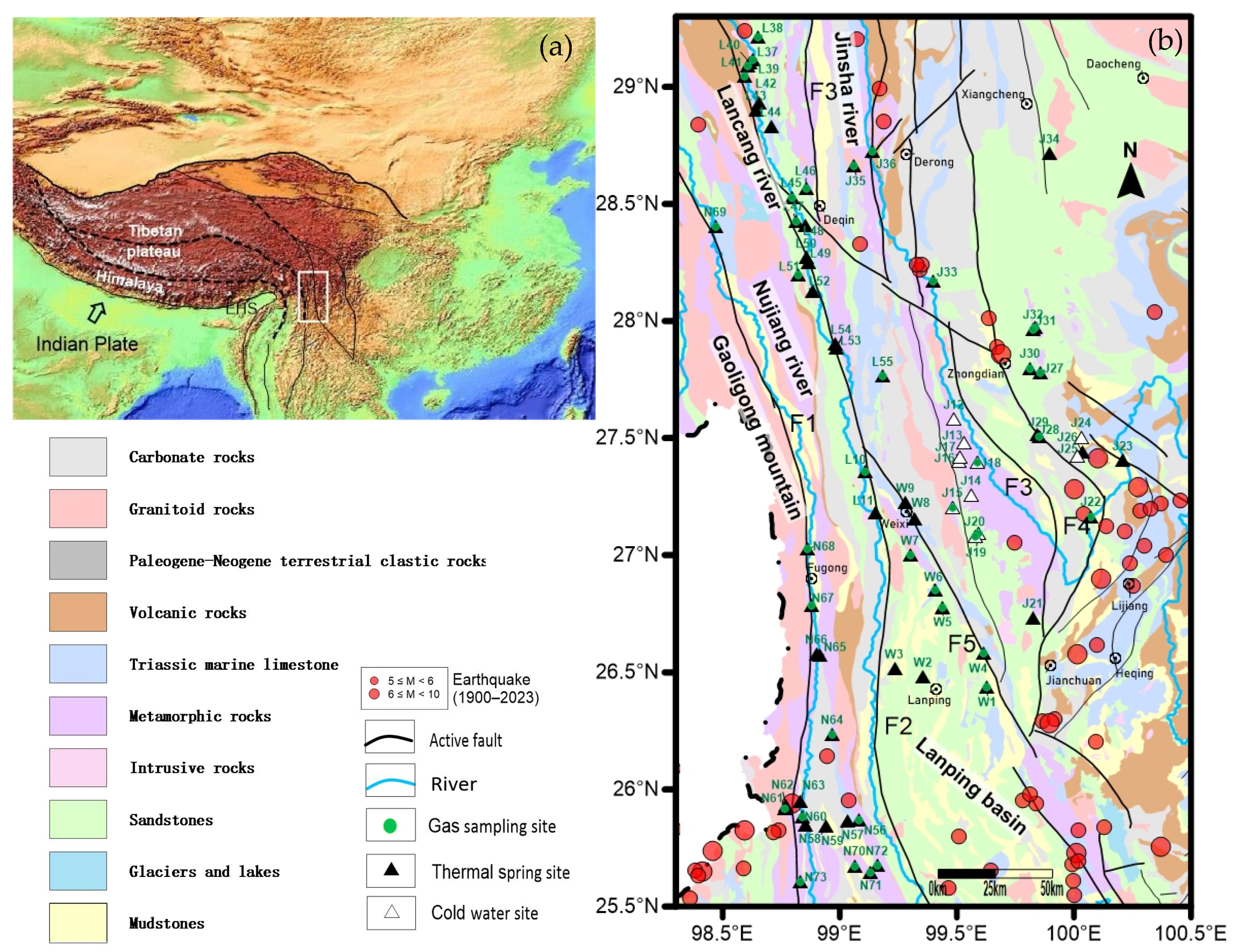
Figure 1. (a) Location of the study area; (b) geological map of the study area and sampling positions (F1: Nujiang Fault; F2: Lancangjiang Fault; F3: Jingshajiang Fault; F4: Zhongdian Fault; and F5: Weixi–Qiaohou Fault).
Minerals 14 00274 g001
Figure 2. Physicochemical parameters and the concentrations of major ions of thermal springs in the TRLCZ.
Minerals 14 00274 g002
Figure 3. Piper diagram of geothermal waters from the TRLCZ [66].
Minerals 14 00274 g003
Figure 4. Relationships of major ions of the spring water in the TRLCZ. (a) Na+ vs. Cl; (b) HCO3 vs. Na+; (c) (Ca2+ + Mg2+) vs. (CO32−+ HCO3); (d) SO42− vs. Ca2+; (e) Cl vs. SO42-; and (f) Cl vs. HCO3.
Minerals 14 00274 g004
Figure 5. Box plot of geothermal waters from the study area.
Minerals 14 00274 g005
Figure 6. The Na-K-Mg trilinear equilibrium diagram of hydrothermal water of the TRLCZ.
Minerals 14 00274 g006
Figure 7. Saturation indices values of water samples with respect to minerals.
Minerals 14 00274 g007
Figure 8. Plot of 3He/4He versus 4He/20Ne ratios.
Minerals 14 00274 g008
Figure 9. (a) Plot of CO2/3He versus δ13C (‰); (b) plot of δ13C (‰) versus CO2.
Minerals 14 00274 g009
Figure 10. Spatial distribution of hydrogeochemical characteristics (H2, CO2, He, and mantle He %) and the circulation depth of thermal springs in the different faults of the TRLCF. (a) H2 concentration; (b) CO2 concentration; (c) He concentration; (d) mantle He proportions.
Minerals 14 00274 g010
Figure 11. Plot of the depth of circulation versus the rate of slip (the size of bubbles reflects the frequency of earthquakes with a magnitude of four or higher occurring along the fault).
Minerals 14 00274 g011
Figure 12. 3He/4He values, reported relative to air, from thermal springs and cold springs within the study region are overlaid on S-wave mantle tomography in the upper mantle (modified from Wang et al. [40]; Fu et al. [92]). Inset shows the correlation (R2 = 0.9) of 3He/4He in each velocity bin relative to the mantle S-wave velocity (Wang et al. [40]).
Minerals 14 00274 g012
Figure 13. Correlation between the 3He/4He ratios (Ra) and strike−slip rates (mm/a) (modified from Wang et al. [108]).
Minerals 14 00274 g013
Figure 14. Fluid circulation model in the TRLCZ.
Minerals 14 00274 g014
Table 1. The estimated reservoir temperatures of thermal springs in the TRLCZ.
Sample No.Reservoir Temperature (°C)Circulation Depth (km)Sample No.Reservoir Temperature (°C)Circulation Depth (km)Sample No.Reservoir Temperature (°C)Circulation Depth (km)
W146.61.6J26129.15.7L51127.65.6
W236.21.1J27135.46.0L52153.96.9
W369.02.7J2850.61.8L5349.91.7
W4136.16.0J2953.11.9L54124.95.5
W570.02.7J3064.22.4L55117.75.1
W647.91.6J31138.96.2N56135.66.0
W775.83.0J32140.56.3N5731.40.8
W870.42.8J3362.32.4N5841.91.3
W971.32.8J34149.76.7N5958.32.2
L1061.62.3J35157.47.1N60114.25.0
L1145.21.5J3656.82.1N61145.26.5
J12--L37132.95.9N62128.95.7
J13--L3857.72.1N6356.72.1
J14--L39134.25.9N6460.82.3
J15--L40111.24.8N6535.01.0
J16--L4172.32.9N6659.32.2
J17--L42118.35.2N6765.92.5
J18--L4371.42.8N68123.65.4
J19--L4425.60.5N69--
J20--L45141.56.3N70116.55.1
J2141.81.3L46148.46.7N71141.76.3
J2257.42.1L47110.04.7N72155.57.0
J2360.22.3L4852.11.8N73144.96.5
J24--L4970.52.8
J25--L5040.71.3
Disclaimer/Publisher’s Note: The statements, opinions and data contained in all publications are solely those of the individual author(s) and contributor(s) and not of MDPI and/or the editor(s). MDPI and/or the editor(s) disclaim responsibility for any injury to people or property resulting from any ideas, methods, instructions or products referred to in the content.