
Geochemistry of Geothermal Fluids in the Three Rivers Lateral Collision Zone in Northwest Yunnan, China: Relevance for Tectonic Structure and Seismic Activity

Abstract
:1. Introduction
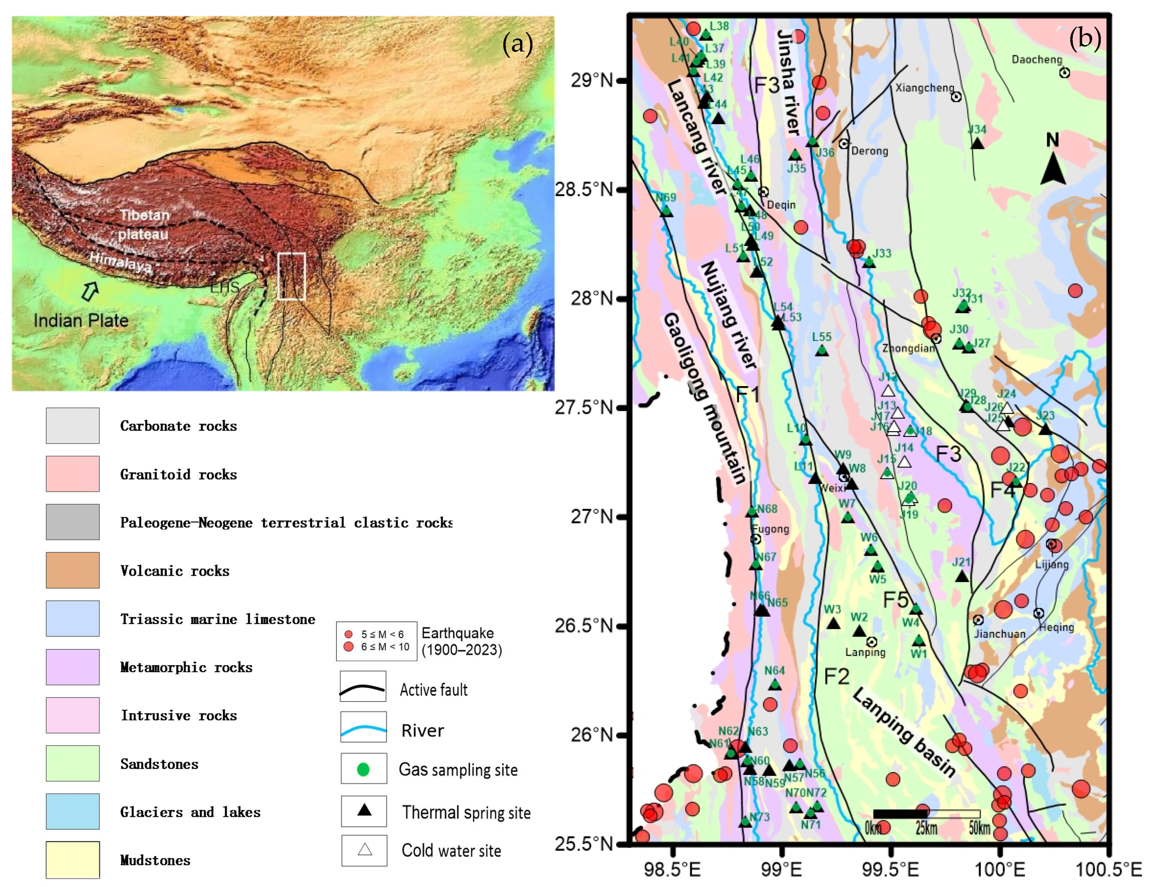
2. Geological Setting
3. Sampling and Analytical Methods
3.1. Water Samples
3.2. Gas Samples
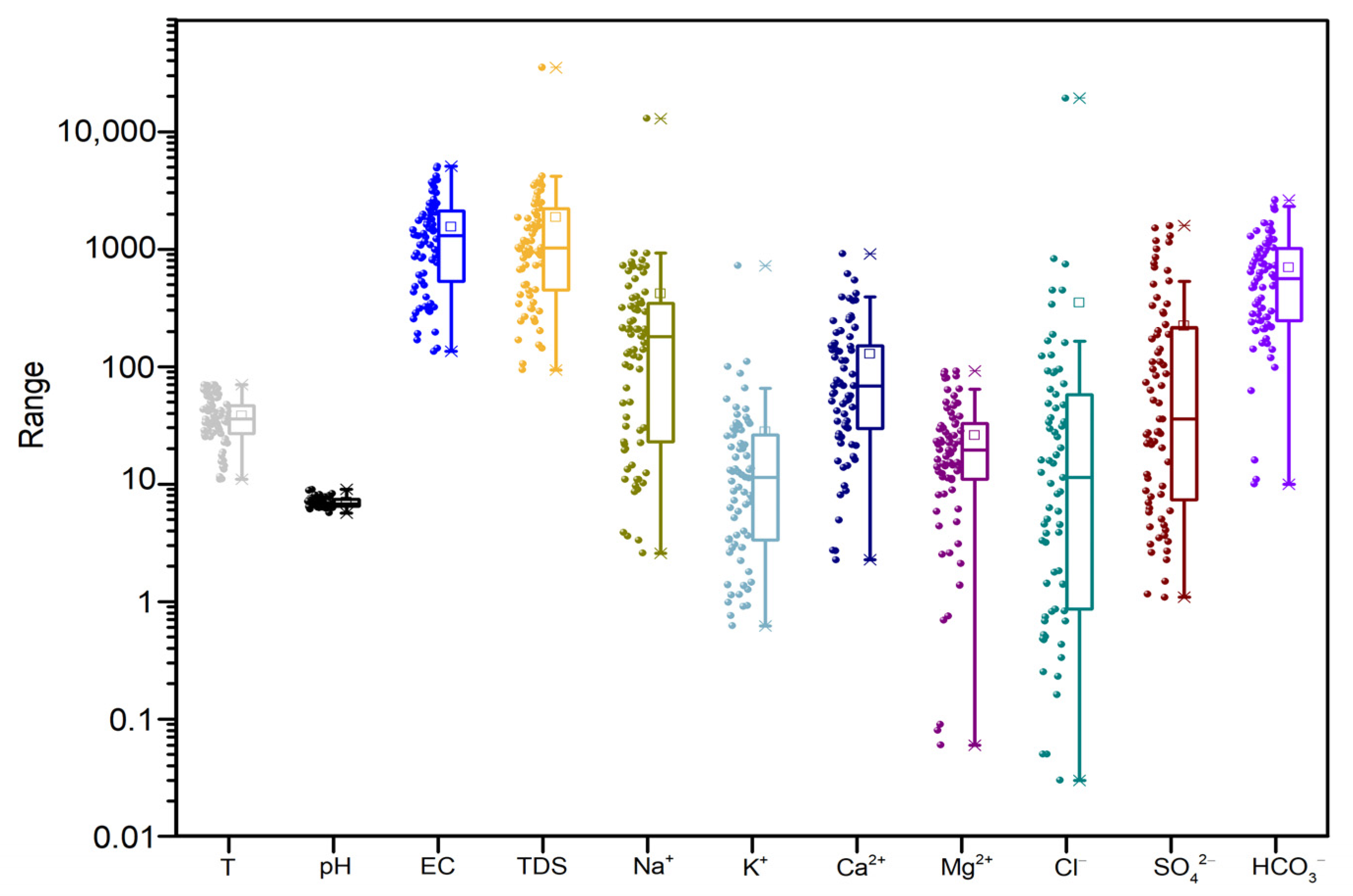
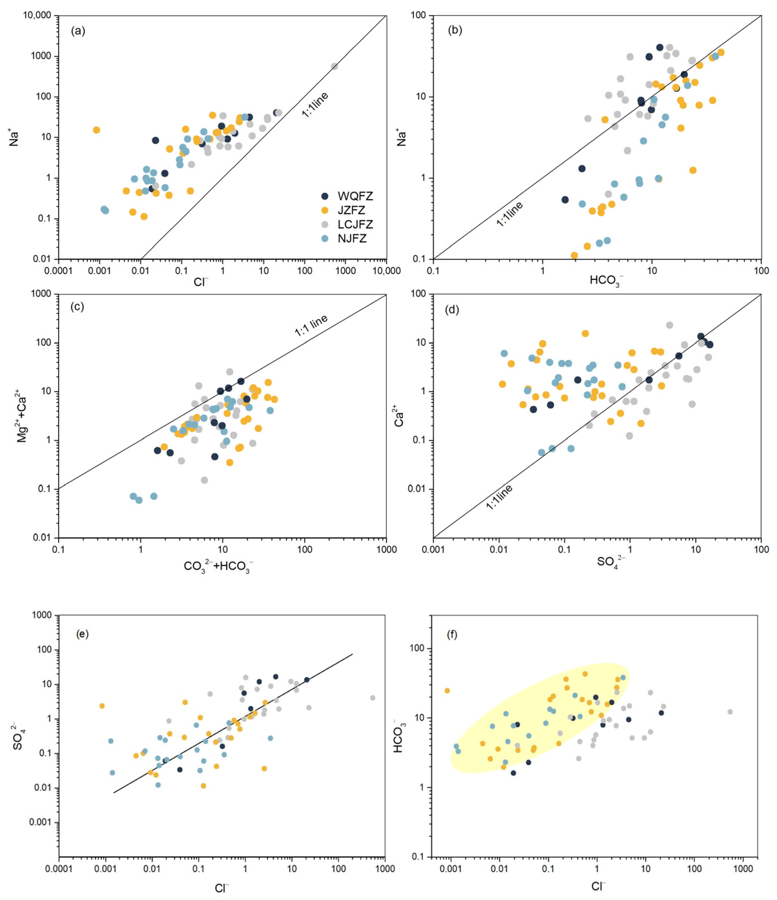
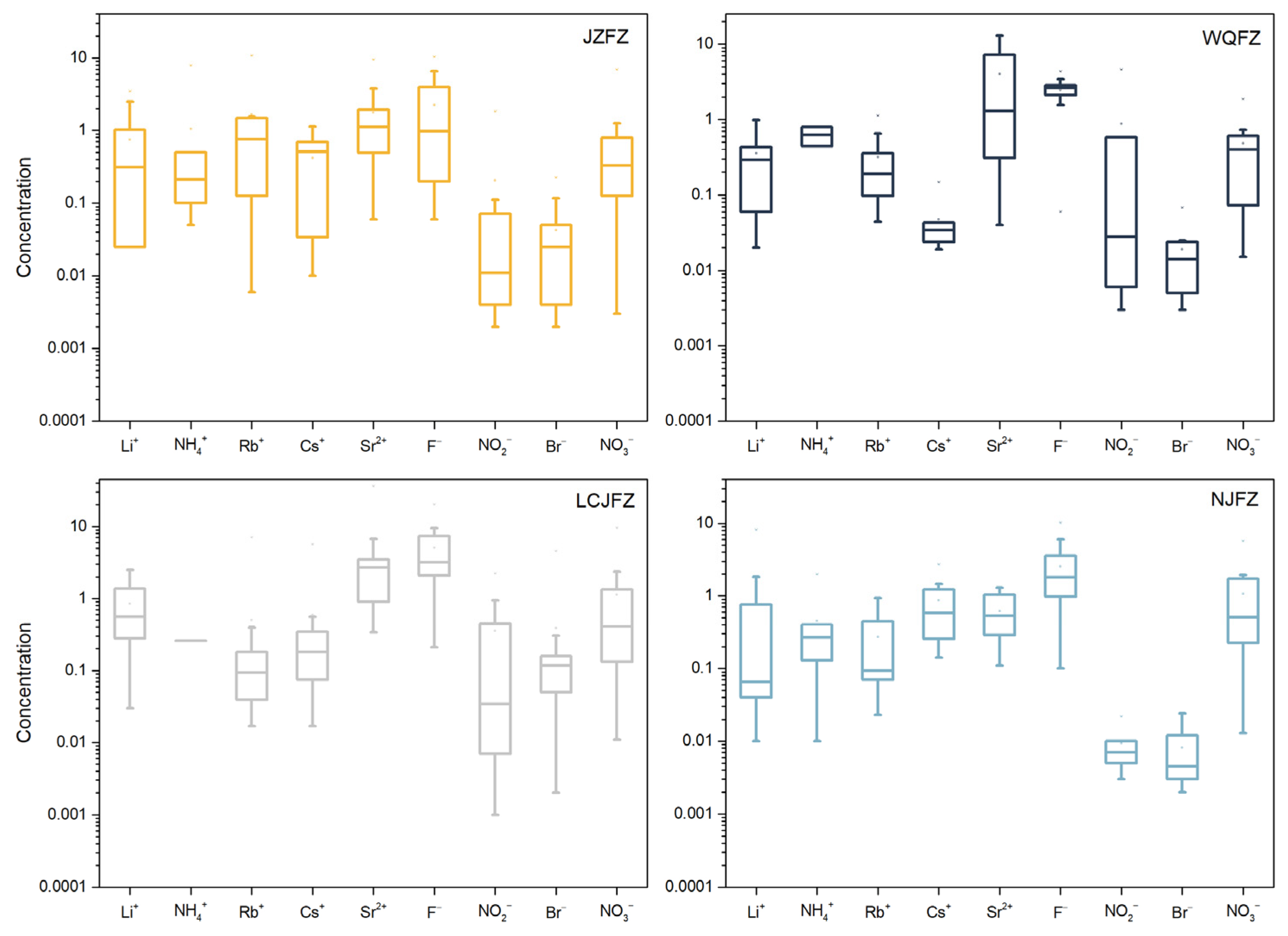
4. Results
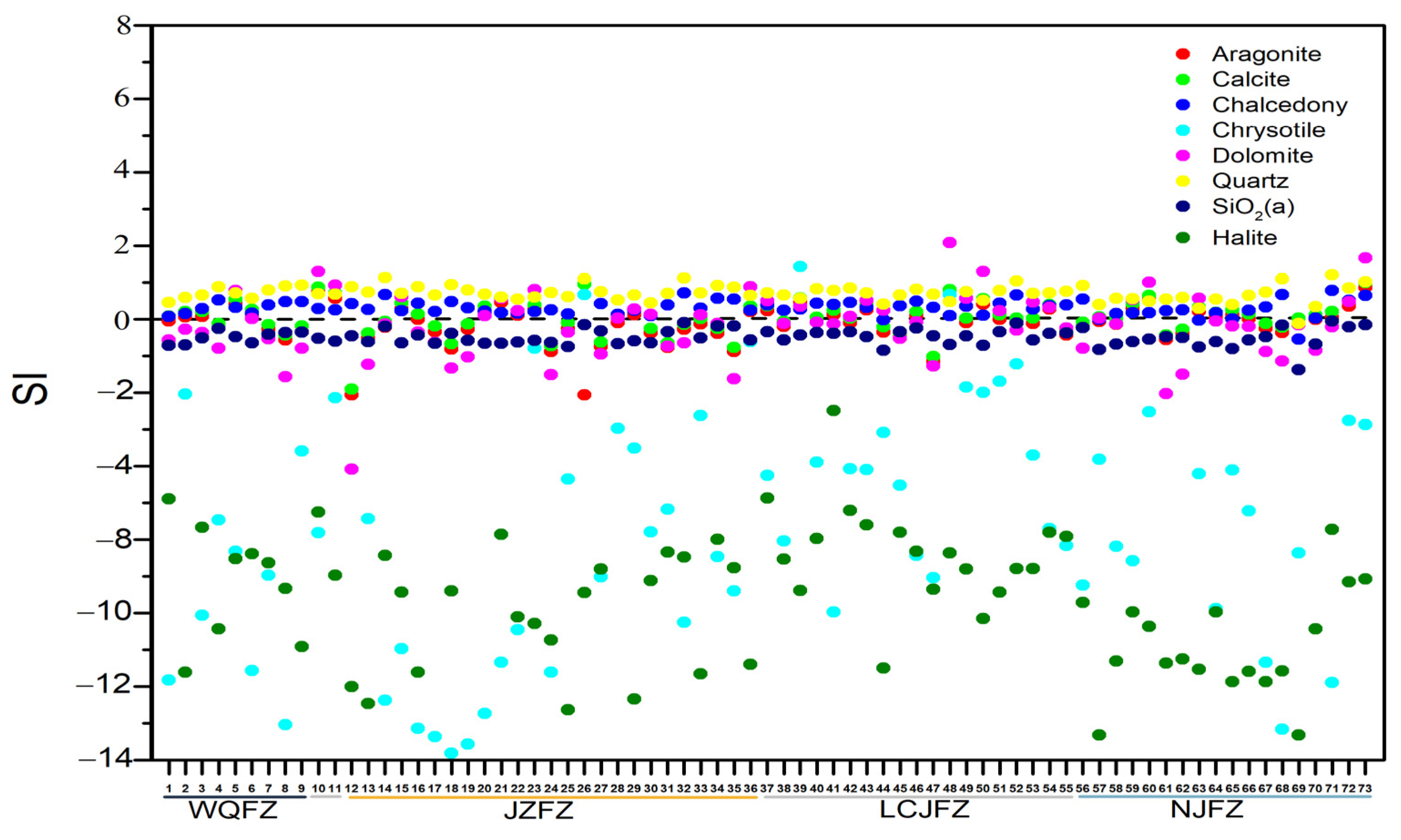
5. Discussion
5.1. Characteristics of Geothermal Water
5.2. Reservoir Temperature and Circulation Depth
5.3. Characteristics of Geothermal Gas
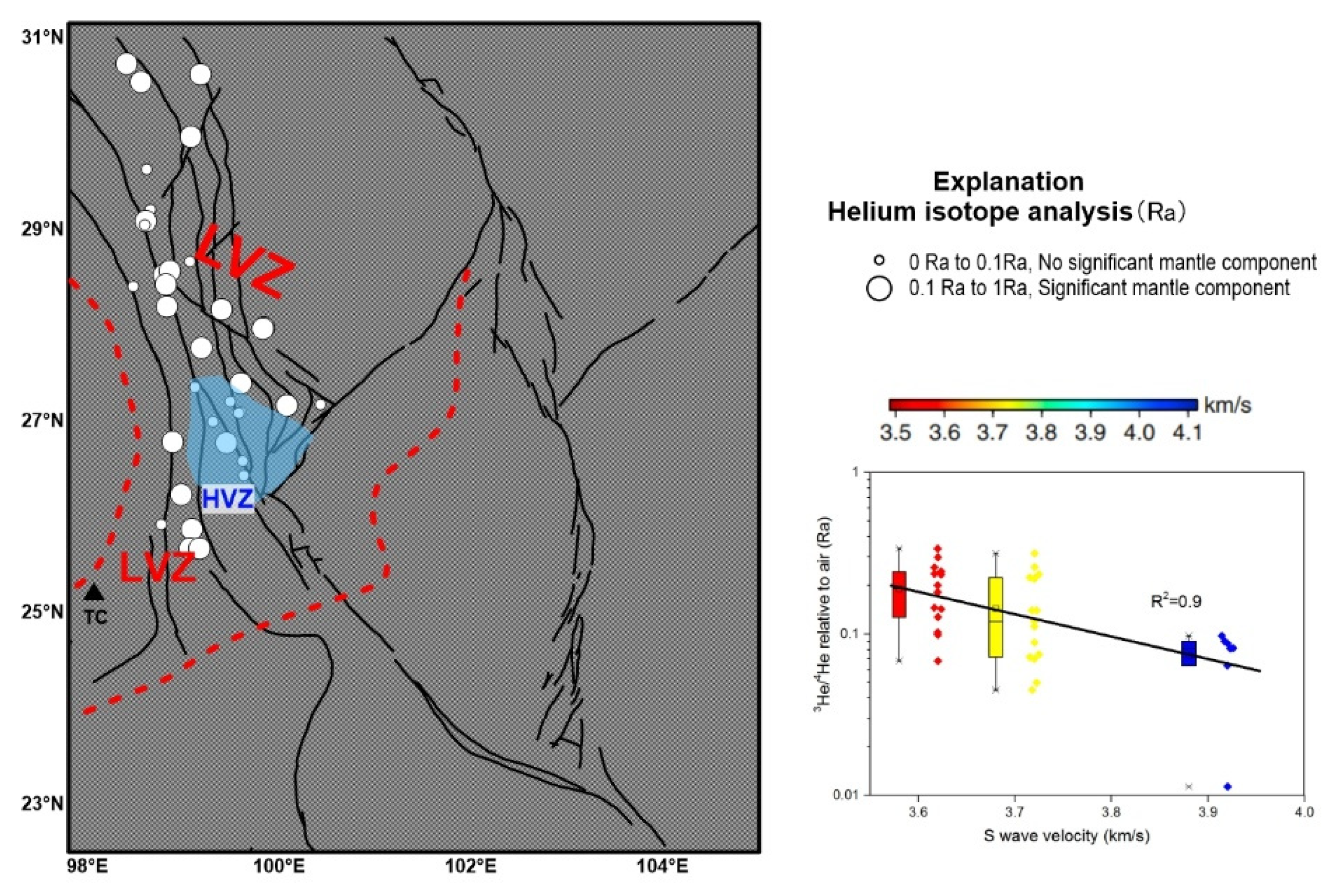
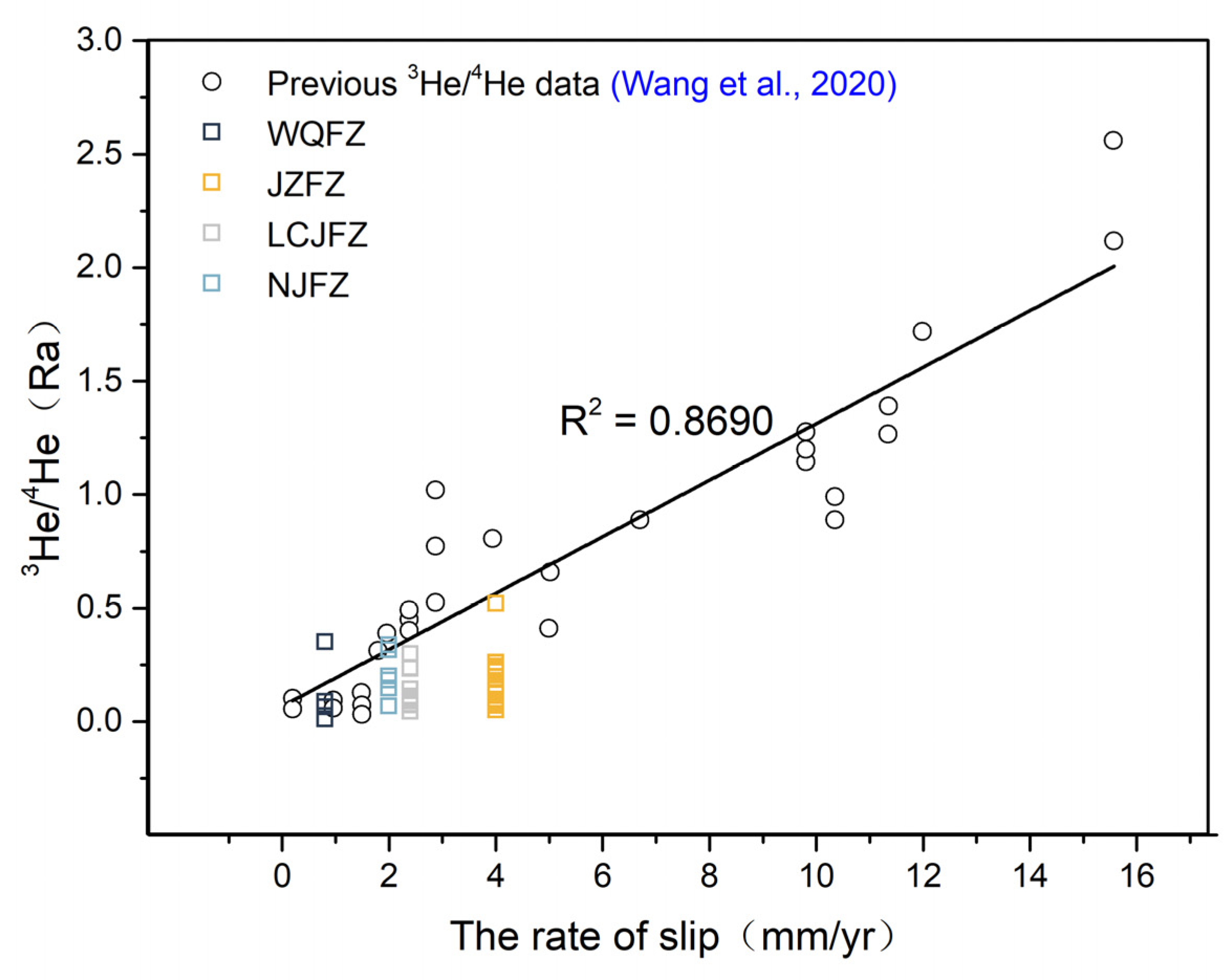
5.3.1. Origin of He
5.3.2. Origin of CO2
5.4. Spatial Distribution of Hydrogeochemical Characteristics in TRLCF
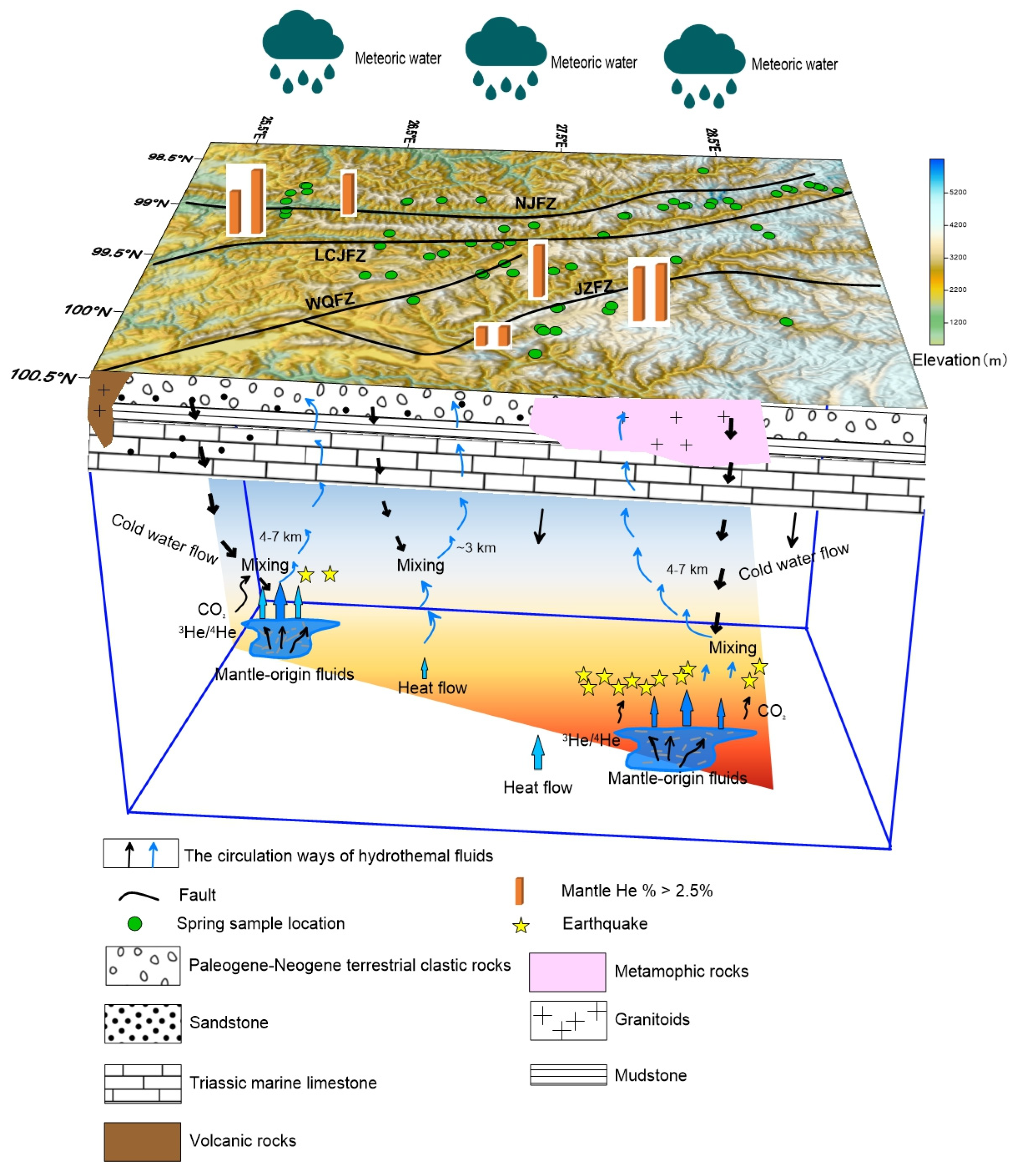
5.5. Fluid Circulation Model
6. Conclusions
Supplementary Materials
Author Contributions
Funding
Data Availability Statement
Acknowledgments
Conflicts of Interest
References
- Kennedy, B.M.; Kharaka, Y.K.; Evans, W.C.; Ellwood, A.; Depaolo, D.J.; Thordsen, J.; Ambats, G.; Mariner, R.H. Mantle fluids in the San Andreas fault system. Calif. Sci. 1997, 278, 1278–1281. [Google Scholar] [CrossRef]
- Italiano, F.; Bonfanti, P.; Pizzino, L.; Quattrocchi, F. Geochemistry of fluids discharged over the seismic area of the Southern Apennines (Calabria region, Southern Italy): Implications for Fluid-Fault relationships. Appl. Geochem. 2010, 25, 540–554. [Google Scholar] [CrossRef]
- Joseph, E.P.; Fournier, N.; Lindsay, J.M.; Fischer, T.P. Gas and water geochemistry of geothermal systems in Dominica, Lesser Antilles Island arc. J. Volcanol. Geoth. Res. 2011, 206, 1–14. [Google Scholar] [CrossRef]
- Wrage, J.; Tardani, D.; Reich, M.; Daniele, L.; Arancibia, G.; Cembrano, J.; P’erezMoreno, R. Geochemistry of thermal waters in the Southern Volcanic Zone, Chile- Implications for structural controls on geothermal fluid composition. Chem. Geol. 2017, 466, 545–561. [Google Scholar] [CrossRef]
- Hilton, D.R. Geochemistry—The leaking mantle. Science 2007, 318, 1389–1390. [Google Scholar] [CrossRef]
- Kennedy, B.M.; van Soest, M.C. Flow of Mantle Fluids Through the Ductile Lower Crust: Helium Isotope Trends. Science 2007, 318, 1433–1436. [Google Scholar] [CrossRef] [PubMed]
- Tian, J.; Pang, Z.; Liao, D.; Zhou, X. Fluid geochemistry and its implications on the role of deep faults in the genesis of high temperature systems in the eastern edge of the Qinghai Tibet Plateau. Appl. Geochem. 2021, 131, 105036. [Google Scholar] [CrossRef]
- Liu, W.; Zhang, M.; Chen, B.; Liu, Y.; Cao, C.; Xu, W.; Zheng, G.; Zhou, X.; Lang, Y.; Sano, Y.; et al. Hydrothermal He and CO2 degassing from a Y-shaped active fault system in eastern Tibetan Plateau with implications for seismogenic processes. J. Hydrol. 2023, 620, 129482. [Google Scholar] [CrossRef]
- Doğan, T.; Sumino, H.; Nagao, K.; Notsu, K.; Tuncer, M.K.; Çelik, C. Adjacent releases of mantle helium and soil CO2 from active faults: Observations from the Marmara region of the North Anatolian Fault zone, Turkey. Geochem. Geophys. Geosystems 2009, 10, Q11009. [Google Scholar] [CrossRef]
- Kulongoski, J.T.; Hilton, D.R.; Barry, P.H.; Esser, B.K.; Hillegonds, D.; Belitz, K. Volatile fluxes through the Big Bend section of the San Andreas Fault, California: Helium and carbon-dioxide systematics. Chem. Geol. 2013, 339, 92–102. [Google Scholar] [CrossRef]
- Zhao, D.P.; Mishra, O.P.; Sanda, R. Influence of fluids and magma on earthquakes: Seismological evidence. Phys. Earth Planet. Inter. 2002, 132, 249–267. [Google Scholar] [CrossRef]
- Lei, J.; Zhao, D. Structural heterogeneity of the Longmenshan fault zone and the mechanism of the 2008 Wenchuan earthquake (Ms 8.0). Geochem. Geophys. Geosyst. 2009, 10, Q10010. [Google Scholar] [CrossRef]
- Salah, M.K.; Zhao, D.P. 3-D seismic structure of Kii Peninsula in southwest Japan: Evidence for slab dehydration in the forearc. Tectonophysics 2003, 364, 191–213. [Google Scholar] [CrossRef]
- Wang, Z.; Zhao, D. Seismic evidence for the influence of fluids on the 2005 west off Fukuoka prefecture earthquake in southwest Japan. Phys. Earth Planet. Inter. 2006, 155, 313–324. [Google Scholar] [CrossRef]
- Xia, S.; Zhao, D.; Qiu, X. The 2007 Niigata earthquake: Effect of arc magma and fluids. Phys. Earth Planet. Inter. 2008, 166, 153–166. [Google Scholar] [CrossRef]
- El Hariri, M.; Abercrombie, R.E.; Rowe, C.A.; Rowe, C.A.; Nascimento, A.F.D. The role of fluids in triggering earthquakes: Observations from reservoir induced seismicity in Brazil. Geophys. J. Int. 2010, 181, 1566–1574. [Google Scholar] [CrossRef]
- Chiodini, G.; Caliro, S.; Cardellini, C. Geochemical evidence for and characterization of CO2 rich gas sources in the epicentral area of the Abruzzo 2009 earthquakes. Earth Planet. Sci. Lett. 2011, 304, 389–398. [Google Scholar] [CrossRef]
- Chiodini, G.; Cardellini, C.; Amato, A. Carbon dioxide Earth degassing and seismogenesis in central and southern Italy. Geophys. Res. Lett. 2004, 31, L07615. [Google Scholar] [CrossRef]
- Becken, M.; Ritter, O.; Bedrosian, P.A.; Weckmann, U. Correlation between deep fluids, tremor and creep along the central San Andreas fault. Nature 2011, 480, 87–90. [Google Scholar] [CrossRef]
- Koch, U.; Heinicke, J.; Vossberg, M. Hydrogeological effects of the latest Vogtland-NW Bohemian swarm quake period (August to December 2000). J. Geodyn. 2003, 35, 107–123. [Google Scholar] [CrossRef]
- Sano, Y.; Hara, T.; Takahata, N.; Kawagucci, S.; Honda, M.; Nishio, Y.; Tanikawa, W.; Hasegawa, A. Hattori, K. Helium anomalies suggest a fluid pathway from mantle to trench during the 2011 Tohoku-Oki earthquake. Nat. Commun. 2014, 5, 3084. [Google Scholar] [CrossRef]
- Sano, Y.; Takahata, N.; Kagoshima, T.; Shibata, T.; Onoue, T.; Zhao, D. Groundwater helium anomaly reflects strain change during the 2016 Kumamoto earthquake in Southwest Japan. Sci. Rep. 2016, 6, 37939. [Google Scholar] [CrossRef]
- Zhou, X.; Wang, W.; Chen, Z.; Yi, L.; Liu, L.; Xie, C.; Cui, Y.; Du, J.; Cheng, J.; Yang, L. Hot Spring Gas Geochemistry in Western Sichuan Province, China After the Wenchuan Ms 8.0 Earthquake. Terr. Atmos. Ocean. Sci. 2015, 26, 361–373. [Google Scholar] [CrossRef]
- Tapponnier, P. Oblique stepwise rise and growth of the Tibet Plateau. Science 2001, 294, 1671–1677. [Google Scholar] [CrossRef]
- Xu, Z.Q.; Yang, J.S.; Li, W.C.; Zeng, L.S.; Xu, C.P. Tectonic background of important metallogenic belts in the southern and southeastern Tibetan Plateau and ore prospecting. Acta Geol. Sin. 2012, 86, 1857–1868. (In Chinese) [Google Scholar]
- Tapponnier, P.; Peltzer, G.; Le Dain, A.Y.; Armijo, R.; Cobbold, P. Propagating extrusion tectonics in Asia: New insights from simple experiments with plasticine. Geology 1982, 10, 611–616. [Google Scholar] [CrossRef]
- Royden, L.H.; Burchfiel, B.C.; van der Hilst, R.D. The geological evolution of the Tibetan Plateau. Science 2008, 321, 1054–1058. [Google Scholar] [CrossRef]
- Li, Q.; Feng, S.; Bai, Z.; Gao, Y.; Gao, S.; Xiong, X.; Wang, X.; Lang, C.; Han, R.; Wu, Q.; et al. New research progress on crust-upper mantle structure in the southeastern margin of Qinghai-Tibet Plateau, China. J. Earth Sci. Environ. 2018, 40, 757–778. (In Chinese) [Google Scholar]
- Bai, M.K.; Chevalier, M.L.; Leloup, P.H.; Li, H.B.; Pan, J.W.; Replumaz, A.; Wang, S.G.; Li, K.Y.; Wu, Q.; Liu, F.C.; et al. Spatial slip rate distribution along the SE Xianshuihe fault, eastern Tibet, and earthquake hazard assessment. Tectonics 2021, 40, e2021TC006985. [Google Scholar] [CrossRef]
- Tang, R.C.; Han, W.B. Active Faults and Earthquakes in Sichuan; Seismological Pres: Beijing, China, 1993. (In Chinese) [Google Scholar]
- Wang, Y.Z.; Wang, E.N.; Shen, Z.K.; Wang, M.; Gan, W.J.; Meng, G.J.; Li, T.M.; Tao, W.; Yang, Y.L.; Cheng, J.; et al. GPS-constrained inversion of present-day slip rates along major faults of the Sichuan-Yunnan region, China. Sci. China, 2008; 51, 1267–1283. (In Chinese) [Google Scholar]
- Tang, F.T.; Song, J.; Cao, Z.Q.; Deng, Z.H.; Wang, M.; Xiao, G.R.; Chen, W.T. The movement characters of main faults around Eastern Himalayan Syntaxis revealed by the latest GPS data. Chin. J. Geophys. 2010, 53, 119–2128. (In Chinese) [Google Scholar]
- Song, J. Study on Current Movement Characteristics and Numerical Simulation of the Main Faults around Eastern Himalayan Syntaxis. Ph.D. Thesis, China Earthquake Administration, Beijing, China, 2011. (In Chinese). [Google Scholar]
- Wang, Y.Z.; Wang, M.; Shen, Z.K.; Shao, D.S.; Shi, F.Q. Present-day slip rates and potential earthquake risks along the Nujiang Fault. Seismol. Geol. 2015, 37, 374–383. (In Chinese) [Google Scholar]
- Wang, M.M.; Liu, S.; Shi, B.X.; Huang, C.C. Geological and geomorphic investigation in the epicenter area of the Shangrila- Derong MS5.9 earthquake in 2013. South China J. Seismol. 2017, 37, 80–88, (In Chinese with English Abstract). [Google Scholar]
- Chang, Z.F.; Zhang, Y.F.; Li, J.L.; Zang, Y.; Dai, B.Y. Recent active features of Weixi-Qiaohou fault and its relationship with the Honghe fault. J. Geomechanics 2016, 22, 517–530. (In Chinese) [Google Scholar]
- Chang, Z.F.; Zang, Y.; Chang, H. New Discovery of Holocene Activity along the Weixi-Qiaohou Fault in Southeastern Margin of the Tibetan Plateau and its Neotectonic Significance. Acta Geol. Sin. 2018, 92, 408–409. [Google Scholar]
- Li, L.; Liu, X.; Wan, Y.; Zheng, Z. Crustal deformation characteristics and recent movement changes of main fault zones in northwest Yunnan revealed by GPS and numerical simulation. Acta Geol. Sin. 2021, 95, 3205–3219. (In Chinese) [Google Scholar]
- Bai, D.; Unsworth, M.J.; Meju, M.A.; Ma, X.; Teng, J.; Kong, X.; Sun, Y.; Sun, J.; Wang, L.; Jiang, C.; et al. Crustal deformation of the eastern Tibetan Plateau revealed by magnetotelluric imaging. Nat. Geosci. 2010, 3, 358–362. [Google Scholar] [CrossRef]
- Wang, W.L.; Wu, J.P.; Fang, L.H.; Lai, G.J.; Yang, T.; Cai, Y. S wave velocity structure in southwest China from surface wave tomography and receiver functions. J. Geophys. Res.-Solid Earth 2014, 119, 1061–1078. [Google Scholar] [CrossRef]
- Bao, X.; Sun, X.; Xu, M.; Eaton, D.W.; Song, X.; Wang, L.; Ding, Z.; Mi, N.; Li, H.; Yu, D.; et al. Two crustal low-velocity channels beneath SE Tibet revealed by joint inversion of Rayleigh wave dispersion and receiver functions. Earth Planet Sci. Lett. 2015, 415, 16–24. [Google Scholar] [CrossRef]
- Li, M.; Zhang, S.; Wang, F.; Wu, T.; Qin, W. Crustal and upper-mantle structure of the southeastern Tibetan Plateau from joint analysis of surface wave dispersion and receiver functions. J. Asian Earth Sci. 2016, 117, 52–63. [Google Scholar] [CrossRef]
- Zhang, Z.Q.; Yao, H.J.; Yang, Y. Shear wave velocity structure of the crust and upper mantle in Southeastern Tibet and its geodynamic implications. Sci. China Earth Sci. 2020, 63, 1278–1293. (In Chinese) [Google Scholar] [CrossRef]
- Zhang, J.L.; Du, L.T.; Zhang, H.Q.; Shi, L.T. Discussion on the relationship between Wenchuan Mw 8 great earthquake and the low velocity and high conductive layer in midcrust. Northwestern Seismol. J. 2008, 30, 405–412. (In Chinese) [Google Scholar]
- Zhao, D.P. Seismological structure of subduction zones and its implications for arc magmatism and dynamics. Phys. Earth Planet. Inter. 2001, 127, 197–214. [Google Scholar] [CrossRef]
- Zhao, D.P.; Tani, H.; Mishra, O.P. Crustal heterogeneity in the 2000 western Tottori earthquake region: Effect of fluids from slab dehydration. Phys. Earth Planet. Inter. 2004, 145, 161–177. [Google Scholar] [CrossRef]
- Ren, Z.; Zhou, X.; Yang, M.; Wang, X.; Zheng, Y.; Li, X.; Shen, Y. Hydrochemical characteristics and formation of the Madeng hot spring in Yunnan, China. Geofluids 2018, 2018, 2368246. [Google Scholar]
- Wang, M.; Zhou, X.; Wang, J.; Li, X.; Liu, H. Occurrence, genesis and travertine deposition of the adong hot springs in northwestern Yunnan of china. Geothermics 2020, 87, 101851. [Google Scholar] [CrossRef]
- Xu, Z.J.; Yang, J.S.; Li, W.C.; Zeng, L.S.; Xu, C.P. Tectonic positioning of important metallogenic belts at southern and southeastern Tibet and ore prospecting. Acta Geol. Sin. 2012, 12, 1857–1868. [Google Scholar]
- Yang, S.W.; Zhang, X.P.; Mei, W.Z.; Yan, C.M.; Zhou, T.Q.; Wu, C.J. Characteristics of important faults and division of tectonic units in the west of Sanjiang orogenic belts, Yunnan province. Geol. Resourc. 2019, 28, 315–331. (In Chinese) [Google Scholar]
- Zhong, K.H.; Liu, Z.C.; Shu, L.S.; Li, F.Y.; Shi, Y.S. The Cenozoic strike-slip kinematics of the Lancangjiang Fault zone. Geol. Rev. 2004, 50, 1–8. (In Chinese) [Google Scholar]
- Deng, J.; Wang, Q.F.; Li, G.J.; Santosh, M. Cenozoic tectono-magmatic and metallogenic processes in the Sanjiang region, southwestern China. Earth Sci. Rev. 2014, 138, 268–299. [Google Scholar] [CrossRef]
- Xu, X.; Ji, L.; Jiang, F.; Zhang, W. Study on current activity features of Jinshajiang fault zone based on GPS and small earthquake. J. Geod. Geodyn. 2020, 40, 1062–1067. (In Chinese) [Google Scholar]
- Qin, X.W.; Ma, H.Z.; Zhang, X.Y.; Cheng, H.D.; Han, J.B.; Li, Y.S.; Miao, W.L.; Hai, Q.Y. Geochemical constraints on the origin and evolution of spring waters in the Changdu-Lanping-Simao Basin, Southwestern China. Acta Geol. Sin. 2019, 93, 1097–1112. [Google Scholar] [CrossRef]
- Zhu, Y.; Liu, S.Y.; Yi, Y.; Li, W.Q.; Zhang, S.D. Spatiotemporal changes of terrestrial water storage in Three Parallel River basins and its response to ENSO. Mount. Res. 2020, 38, 165–179. (In Chinese) [Google Scholar]
- Wang, X.C.; Zhou, X.; Zhao, J.B.; Zheng, Y.H.; Song, C.; Long, M.; Chen, T. Hydrochemical evolution and reaction simulation of travertine deposition of the Lianchangping hot springs in Yunnan, China. Quat. Int. 2015, 374, 62–75. [Google Scholar] [CrossRef]
- Li, Q.; Zhao, C.; Wang, Y.; Zhou, Y.; Ran, H. Hydrogeochemistry of hot springs and the 2018 Mojiang M 5.9 earthquake−related chemical changes in the Simao Basin, China. Front. Earth Sci. 2022, 9, 717680. [Google Scholar] [CrossRef]
- Baird, R.B.; Eaton, A.D.; Rice, E.W. Standard Methods for Examination of Water and Wastewater, 23rd ed.; American Public Health Association (APHA): Washington, DC, USA; American Water Works Association (AWWA): Camden, NJ, USA; Water Environment Federation (WEF): Washington, DC, USA, 2017. [Google Scholar]
- Zhao, C.; Wang, Y.; Zhou, Z.; Li, Z.; Xing, L. Present-day temperatures of magma chambers in the crust beneath Ninger volcanic field, southwestern China: Estimation from CO2-CH4 carbon isotope geothermometer. Acta Petrol. Sin. 2017, 33, 231–249. (In Chinese) [Google Scholar]
- Ye, X.R.; Tao, M.X.; Yu, C.A.; Zhang, M.J. Helium and neon isotopic compositions in the ophiolites from the Yarlung Zangbo River, Southwestern China: The information from deep mantle. Sci. China Ser. D Earth Sci. 2007, 50, 801–812. (In Chinese) [Google Scholar] [CrossRef]
- Ozima, M.; Podosek, F.A. Noble Gas Geochemistry, 2nd ed.; Cambridge Univ. Press: Cambridge, UK, 2002. [Google Scholar]
- de Leeuw, G.A.M.; Hilton, D.R.; Güleç, N.; Mutlu, H. Regional and temporal variations in CO2/3He, 3He/4He and δ13C along the North Anatolian Fault Zone, Turkey. Appl. Geochem. 2010, 25, 524–539. [Google Scholar] [CrossRef]
- Weiss, R.F. Solubility of helium and neon in water and seawater. J. Chem. Eng. Data. 1971, 16, 235–241. [Google Scholar] [CrossRef]
- Li, Z.P.; Tao, M.X.; Li, L.W.; Wang, Z.D.; Du, L.; Zhang, M.F. Determination of isotope composition of dissolved inorganic carbon by gas-chromatography conventional isotope-ratio mass spectrometry. Chin. J. Anal. Chem. 2007, 35, 1455–1458. (In Chinese) [Google Scholar] [CrossRef]
- Zhou, X.C.; Liu, L.; Chen, Z. Gas geochemistry of the hot spring in the Litang fault zone, Southeast Tibetan Plateau. Appl. Geochem. 2017, 79, 17–26. [Google Scholar] [CrossRef]
- Piper, A.M. A graphic procedure in the geochemical interpretation of water analyses. Eos. Trans. Am. Geophys. Union. 1944, 25, 914–928. [Google Scholar]
- Du, J.G.; Liu, C.; Fu, B.; Zhang, Y.; Wang, C.; Wang, H.; Sun, Z. Variations of geothermometry and chemical-isotopic compositions of hot spring fluids in the Rehai geothermal field, Southwest China. J. Volcanol. Geoth. Res. 2005, 142, 243–261. [Google Scholar] [CrossRef]
- Zhou, H.; Zhou, X.; Su, H.; Li, Y.; Liu, F.; Ouyang, S.; Yan, Y.; Bai, R. Hydrochemical Characteristics of Earthquake-Related Thermal Springs along the Weixi–Qiaohou Fault, Southeast Tibet Plateau. Water 2022, 14, 132. [Google Scholar] [CrossRef]
- Zhang, J.S.; Li, Y.; Han, Z.J. Deformation responses to eastwards escaping of the Qinghai Tibet plateau and tectonics of the south-north seismic zone in China. Earth Sci. Front. 2003, 10, 168–175. (In Chinese) [Google Scholar]
- Cai, C.; Franks, S.G.; Aagaard, P. Origin and Migration of Brines from Paleozoic Strata in Central Tarim, China: Constraints from 87Sr/86Sr, δD, δ18O and Water Chemistry. Appl. Geochem. 2001, 16, 1269–1284. [Google Scholar] [CrossRef]
- Xing, L.N.; Guo, H.M.; Wei, L.; Zhan, Y.H.; Hou, C.T.; Li, R.M.; Wang, Y. Evolution feature and gensis of fluoride groudwater in shallow aquifer from north China plain. J. Earth Sci. Environ. 2012, 34, 57–67. (In Chinese) [Google Scholar]
- Giggenbach, W.F. Geothermal Solute Equilibria. Derivation of Na-K-Mg Ca Geoindicators. Geochim. Cosmochim. Acta 1988, 52, 2749–2765. [Google Scholar] [CrossRef]
- Rouabhia, A.; Djabri, L.; Hadji, R.; Baali, F.; Fahdi, C.; Hanni, A. Geochemical characterization of groundwater from shallow aquifer surrounding Fetzara Lake NE Algeria. Arab. J. Geosci. 2012, 5, 1–13. [Google Scholar]
- Fournier, R.O.; Rowe, J.J. Estimation of underground temperatures from the silica content of water from hot springs and wet-steam wells. Am. J. Sci. 1966, 264, 685–697. [Google Scholar] [CrossRef]
- Arnórsson, S.; Gunnlaugsson, E.; Svavarsson, H. The geochemistry of geothermal waters in Iceland. II-Mineral equilibria and independent variables controlling water composition. Geochim. Cosmochim. Acta 1983, 47, 547–566. [Google Scholar] [CrossRef]
- Wu, Q.F.; Zu, J.H.; Xie, Y.Z.; Wang, D. Characteristics of geothermal filed in Yunnan region. Seismol. Geol. 1988, 10, 177–183. (In Chinese) [Google Scholar]
- Clarke, W.B.; Beg, M.; Craig, H. Excess 3He in the sea: Evidence for terrestrial primodal helium. Earth Planet. Sci. Lett. 1969, 6, 213–220. [Google Scholar] [CrossRef]
- O’nions, R.K.; Oxburgh, E.R. Helium, Volatile Fluxes and the Development of continental Crust. Earth Planet. Sci. Lett. 1988, 90, 331–347. [Google Scholar] [CrossRef]
- Sano, W.; Wakita, H. Geographical distribution of 3He/4He ratios in Japan: Implications for arc tectonics and incipient magmatism. J. Geophys. Res. 1985, 90, 8729–8741. [Google Scholar] [CrossRef]
- Graham, B.W. Noble Gas Isotope Geochemistry of Mid-Ocean Ridge and Ocean Island Basalts: Characterization of Mantle Source Reservoirs. In Noble Gases in Geochemistry and Cosmochemistry; Porcelli, D., Ballentine, C.J., Wieler, R., Eds.; Reviews in Mineralogy & Geochemistry: Washington, DC, USA, 2002; pp. 247–317. [Google Scholar]
- Lupton, J.E. Terrestrial inert gases-isotope tracer studies and clues to primordial components in the mantle. Annu. Rev. EarthPlanet. Sci. 1983, 11, 371–414. [Google Scholar] [CrossRef]
- Zhou, X.C.; Wang, W.L.; Li, L.W.; Hou, J.M.; Xing, L.T.; Li, Z.P.; Shi, H.Y.; Yan, Y.C. Geochemical features of hot spring gases in the Jinshajiang-Red River fault zone, Southeast Tibetan Plateau. Acta Petrol. Sin. 2020, 36, 2197. [Google Scholar]
- Ballentine, C.J.; Marty, B.; Sherwood Lollar, B.; Cassidy, M. Neon isotopes constrain convection and volatile origin in the Earth’s mantle. Nature 2005, 433, 33–38. [Google Scholar] [CrossRef]
- Klemperer, S.L.; Zhao, P.; Whyte, C.J.; Darrah, T.H.; Crossey, L.J.; Karlstromd, K.E.; Liu, T.Z.; Winn, C.; Hilton, D.R.; Ding, L. Limited underthrusting of India below Tibet: 3He/4He analysisof thermal springs locates the mantle suture incontinental collision. Earth Atmos. Planet. Sci. 2022, 119, e2113877119. [Google Scholar]
- Ballentine, C.J.; Burnard, P.G. Production, Release and Transport of Noble Gases in the Continental Crust. Rev. Mineral. Geochem. 2002, 47, 481–538. [Google Scholar] [CrossRef]
- Hoke, L.; Hilton, D.R.; Lamb, S.H.; Hammerschmidt, K.; Friedrichsen, H. 3He evidence for a wide zone of active mantle melting beneath the Central Andes. Earth Planet. Sci. Lett. 1994, 128, 341–355. [Google Scholar] [CrossRef]
- Cauquoin, A.; Jean-Baptiste, P.; Risi, C.; Fourré, É.; Stenni, B.; Landais, A. The global distribution of natural tritium in precipitation simulated with an Atmospheric General Circulation Model and comparison with observations. Earth Planet. Sci. Lett. 2015, 427, 160–170. [Google Scholar] [CrossRef]
- Kennedy, S.L.; Kennedy, B.M.; Sastry, S.R.; Makovsky, Y.; Harinarayana, T.; Leech, M.L. Mantle fluids in the Karakoram fault: Helium isotope evidence. Earth Planet. Sci. Lett. 2013, 366, 59–70. [Google Scholar]
- Crossey, L.J.; Karlstrom, K.E.; Springer, A.E.; Newell, D.; Fischer, T. Degassing of mantle-derived CO2 and He from springs in the southern Colorado Plateau region-Neotectonic connections and implications for groundwater systems. Geol. Soc. Am. Bull. 2009, 121, 1034–1053. [Google Scholar] [CrossRef]
- Horiguchi, K.; Ueki, S.; Sano, Y.; Takahata, N.; Hasegawa, A.; Igarashi, G. Geographical distribution of helium isotope ratios in northeastern Japan. Isl. Arc 2010, 19, 60–70. [Google Scholar] [CrossRef]
- Zhang, W.B.; Du, J.G.; Zhou, X.C.; Wang, F. Mantle volatiles in spring gases in the Basin and Range Province on the west of Beijing, China. J. Volcanol. Geotherm. Res. 2016, 309, 45–52. [Google Scholar] [CrossRef]
- Fu, Y.Y.; Gao, Y.; Li, A.B.; Li, L.; Chen, A.G. Lithospheric structure of the southeastern margin of the Tibetan Plateau from Rayleigh wave tomography. J. Geophys. Res. Solid Earth 2017, 122, 4631–4644. [Google Scholar] [CrossRef]
- Shen, Z.K.; Lu, J.N.; Wang, M.; Rurgmann, R. Contemporary crustal deformation around the southeast borderland of the Tibetan Plateau. J. Geophys. Res. 2005, 110, B11409. [Google Scholar] [CrossRef]
- Li, R.J.; Zhao, L.F.; Xie, X.B.; Yao, Z.X. Crustal deformation in the southeastern margin of the Tibetan Plateau: Insights from broad-band Pg-wave attenuation tomography. Geophys. J. Int. 2023, 235, 2870–2886. [Google Scholar] [CrossRef]
- Kyser, T.K. Stable isotope variations in the mantle. In Stable Isotopes in High Temperature Geological Processes; Volume 16 in the Series Reviews in Mineralogy & Geochemistry; Valley, J.W., Taylor, H.P., Jr., O’Neil, J.R., Eds.; De Gruyter: Berlin, Germany, 1986; pp. 141–164. [Google Scholar]
- Craig, H. The isotopic geochemistry of water and carbon in geothermal area. In Nuclear Geology on Geothermal Areas; Tongiorgi, E., Ed.; Consiglio Nazionale Delle Ricerche Laboratorio Di Geologia Nucleare-Pisa: Pisa, Italy, 1963; pp. 17–53. [Google Scholar]
- Deines, P.; Gold, D.P. The isotopic composition of carbonatite and kimberlite carbonates and their bearing on the isotopic composition of deep-seated carbon. Geochim. Cosmochim. Acta 1973, 37, 1709–1733. [Google Scholar] [CrossRef]
- Paonita, A.; Favara, R.; Nuccio, P.M.; Sortino, F. Genesis of fumarolic emissions as inferred by isotope mass balances: CO2 and water at Vulcano Island, Italy. Geochim. Cosmochim. Acta 2002, 66, 759–772. [Google Scholar] [CrossRef]
- Faure, G.; Hurley, P.M.; Powell, J.L. The Isotopic Composition of Strontium in Surface Water from the North Atlantic Ocean. Geochim. Cosmochim. Acta. 1965, 29, 209–220. [Google Scholar] [CrossRef]
- Sano, Y.; Marty, B. Origin of carbon in fumarolic gas from island arcs. Chem. Geol. 1995, 119, 265–274. [Google Scholar] [CrossRef]
- Kita, I.; Matsuo, S.; Wakita, H.; Nakamura, Y. D/H ratios of H2 in soil gases as an indicator of fault movements. Geochem. J. 1980, 14, 317–320. [Google Scholar] [CrossRef]
- Tang, H.H.; Guo, L.H.; Fang, Y. Estimation of heat flow in southeastern margin of Tibetan Plateau and its analysis of the correlation with earthquake activity. Chin. J. Geophys. 2020, 63, 1056–1069. (In Chinese) [Google Scholar]
- Wang, B.; Zhou, Y.S.; Zhong, J.; Wang, Y.; Xie, M.Y.; Wang, Y.; Hu, X.J.; Zhang, X. Tectonic geothermal feature of Northwest Yunnan and the influence on seismic activity. Chin. J. Geophys. 2022, 65, 3419–3433. (In Chinese) [Google Scholar]
- Kameda, J.; Saruwatari, K.; Tanaka, H. H2 generation in wet grinding of granite and single-crystal powders and implications for H2 concentration on active faults. Geophys. Res. Lett. 2003, 30, 2063. [Google Scholar] [CrossRef]
- Kita, I.; Matsuo, S.; Wakita, H. H2 generation by reaction between H2O and crushed rock: An experimental study on H2 degassing from the active fault zone. J. Geophys. Res. 1982, 87, 10789. [Google Scholar] [CrossRef]
- Garrels, R.M.; Christ, C.L. ; Solutions, Minerals, and Equilibria; Harper & Row: New York, NY, USA, 1965. [Google Scholar]
- Li, W.J.; Shao, Z.G.; Wen, X.Z.; Wang, Q.X.; Wang, G.C.; Zhang, Y.; Jiang, C.S.; Wang, W.X. Deep structure derived from the Mouding Shangri-La magnetotelluric profile in western Yunnan Province. Chin. J. Geophys. 2016, 59, 229–239. (In Chinese) [Google Scholar]
- Luo, S.; Yu, C.Q.; Zhang, G.; Li, D.W.; Qu, C.; Zhang, H.M.; Tian, Z.Y.; Huang, J. Deep electrical resistivity structure of the Sanjiang Area, western Yunnan: An example of the Fugong-Qiaojia profile. Chin. J. Geophys. 2020, 63, 1026–1042. (In Chinese) [Google Scholar]
- Zhao, C.; Ran, H.; Wang, Y. Present-day mantle-derived helium release in the Tengchong volcanic field, Southwest China: Implications for tectonics and magmatism. Acta Petrol. Sin. 2012, 28, 1189–1204. (In Chinese) [Google Scholar]
- Wang, Y.; Liu, Y.; Zhao, C.; Li, Q.; Ran, H. Helium and carbon isotopic signatures of thermal spring gases in southeast Yunnan, China. J. Volcanol. Geotherm. Res. 2020, 402, 106995. [Google Scholar] [CrossRef]
- Giammanco, S.; Palano, M.; Scaltrito, A.; Scarfi, L.; Sortino, F. Possible role of fluid overpressure in the generation of earthquake swarms in active tectonic areas: The case of the Peloritani Mts. (Sicily, Italy). J. Volcanol. Geotherm. Res. 2008, 178, 795–806. [Google Scholar] [CrossRef]
- Terakawa, T.; Miller, S.A.; Deichmann, N. High fluid pressure and triggered earthquakes in the enhanced geothermal system in Basel, Switzerland. J. Geophys. Res. 2012, 117, B07305. [Google Scholar] [CrossRef]
- Fulton, P.M.; Saffer, D.M.; Bekins, B.A. A critical evaluation of crustal dehydration as the cause of an overpressured and weak San Andreas Fault. Earth Planet. Sci. Lett. 2009, 284, 447–454. [Google Scholar] [CrossRef]
- Leach, D.L.; Song, Y.C.; Hou, Z.Q. The world-class Jinding Zn-Pb deposit: Ore formation in an evaporite dome, Lanping Basin, Yunnan, China. Mineral. Depos. 2016, 52, 281–296. [Google Scholar] [CrossRef]
- Tian, J.; Stefánsson, A.; Li, Y.; Li, L.; Xing, L.; Li, Z.; Li, Y.; Zhou, X. Geochemistry of thermal fluids and the genesis of granite-hosted Huangshadong geothermal system, Southeast China. Geothermics 2023, 109, 102647. [Google Scholar] [CrossRef]
- Wang, L.; Chen, S.; Zhuang, J.; Zhang, B.; Shi, W.; Yang, J.; Xu, W. Gravity field changes reveal deep mass transfer before and after the 2013 Lushan earthquake. Commun. Earth Environ. 2023, 4, 194. [Google Scholar] [CrossRef]


| Sample No. | Reservoir Temperature (°C) | Circulation Depth (km) | Sample No. | Reservoir Temperature (°C) | Circulation Depth (km) | Sample No. | Reservoir Temperature (°C) | Circulation Depth (km) |
|---|---|---|---|---|---|---|---|---|
| W1 | 46.6 | 1.6 | J26 | 129.1 | 5.7 | L51 | 127.6 | 5.6 |
| W2 | 36.2 | 1.1 | J27 | 135.4 | 6.0 | L52 | 153.9 | 6.9 |
| W3 | 69.0 | 2.7 | J28 | 50.6 | 1.8 | L53 | 49.9 | 1.7 |
| W4 | 136.1 | 6.0 | J29 | 53.1 | 1.9 | L54 | 124.9 | 5.5 |
| W5 | 70.0 | 2.7 | J30 | 64.2 | 2.4 | L55 | 117.7 | 5.1 |
| W6 | 47.9 | 1.6 | J31 | 138.9 | 6.2 | N56 | 135.6 | 6.0 |
| W7 | 75.8 | 3.0 | J32 | 140.5 | 6.3 | N57 | 31.4 | 0.8 |
| W8 | 70.4 | 2.8 | J33 | 62.3 | 2.4 | N58 | 41.9 | 1.3 |
| W9 | 71.3 | 2.8 | J34 | 149.7 | 6.7 | N59 | 58.3 | 2.2 |
| L10 | 61.6 | 2.3 | J35 | 157.4 | 7.1 | N60 | 114.2 | 5.0 |
| L11 | 45.2 | 1.5 | J36 | 56.8 | 2.1 | N61 | 145.2 | 6.5 |
| J12 | - | - | L37 | 132.9 | 5.9 | N62 | 128.9 | 5.7 |
| J13 | - | - | L38 | 57.7 | 2.1 | N63 | 56.7 | 2.1 |
| J14 | - | - | L39 | 134.2 | 5.9 | N64 | 60.8 | 2.3 |
| J15 | - | - | L40 | 111.2 | 4.8 | N65 | 35.0 | 1.0 |
| J16 | - | - | L41 | 72.3 | 2.9 | N66 | 59.3 | 2.2 |
| J17 | - | - | L42 | 118.3 | 5.2 | N67 | 65.9 | 2.5 |
| J18 | - | - | L43 | 71.4 | 2.8 | N68 | 123.6 | 5.4 |
| J19 | - | - | L44 | 25.6 | 0.5 | N69 | - | - |
| J20 | - | - | L45 | 141.5 | 6.3 | N70 | 116.5 | 5.1 |
| J21 | 41.8 | 1.3 | L46 | 148.4 | 6.7 | N71 | 141.7 | 6.3 |
| J22 | 57.4 | 2.1 | L47 | 110.0 | 4.7 | N72 | 155.5 | 7.0 |
| J23 | 60.2 | 2.3 | L48 | 52.1 | 1.8 | N73 | 144.9 | 6.5 |
| J24 | - | - | L49 | 70.5 | 2.8 | |||
| J25 | - | - | L50 | 40.7 | 1.3 |
Disclaimer/Publisher’s Note: The statements, opinions and data contained in all publications are solely those of the individual author(s) and contributor(s) and not of MDPI and/or the editor(s). MDPI and/or the editor(s) disclaim responsibility for any injury to people or property resulting from any ideas, methods, instructions or products referred to in the content. |
© 2024 by the authors. Licensee MDPI, Basel, Switzerland. This article is an open access article distributed under the terms and conditions of the Creative Commons Attribution (CC BY) license (https://creativecommons.org/licenses/by/4.0/).
Share and Cite
Li, Q.; Wang, Y.; Zhao, C.; Ran, H. Geochemistry of Geothermal Fluids in the Three Rivers Lateral Collision Zone in Northwest Yunnan, China: Relevance for Tectonic Structure and Seismic Activity. Minerals 2024, 14, 274. https://doi.org/10.3390/min14030274
Li Q, Wang Y, Zhao C, Ran H. Geochemistry of Geothermal Fluids in the Three Rivers Lateral Collision Zone in Northwest Yunnan, China: Relevance for Tectonic Structure and Seismic Activity. Minerals. 2024; 14(3):274. https://doi.org/10.3390/min14030274
Chicago/Turabian StyleLi, Qilin, Yun Wang, Ciping Zhao, and Hua Ran. 2024. "Geochemistry of Geothermal Fluids in the Three Rivers Lateral Collision Zone in Northwest Yunnan, China: Relevance for Tectonic Structure and Seismic Activity" Minerals 14, no. 3: 274. https://doi.org/10.3390/min14030274