
Three-Dimensional Electrical Structure and Metallogenic Background of the Southeastern Hubei Ore Concentration Area
 , ,
, , 
Abstract
:1. Introduction
- The continental extension model [5]: This suggests that the large-scale magmatic activity in the middle and lower reaches of the Yangtze River region is related to the continental collision between the Yangtze and North China Cratons, followed by extensional events.
- The plate subduction model [6]: This proposes that the large-scale magmatic activity in the middle and lower reaches of the Yangtze River region is associated with the subduction of the Paleo-Pacific Plate.
- The delamination model [2,7]: This suggests that during the collision process between the Yangtze Craton and the North China Craton, the eastern part of the Yangtze Craton collided and squeezed into the North China Craton, forming the Tancheng-Lujiang Fault on the western side of the intrusion. The ore-bearing belt in the middle and lower reaches of the Yangtze River is located on the western side of the Tancheng-Lujiang Fault. This region’s subsequent large-scale magmatic activity is attributed to lithospheric mantle delamination and asthenospheric upwelling caused by the relative rotation between the North China Craton and the Yangtze Craton.
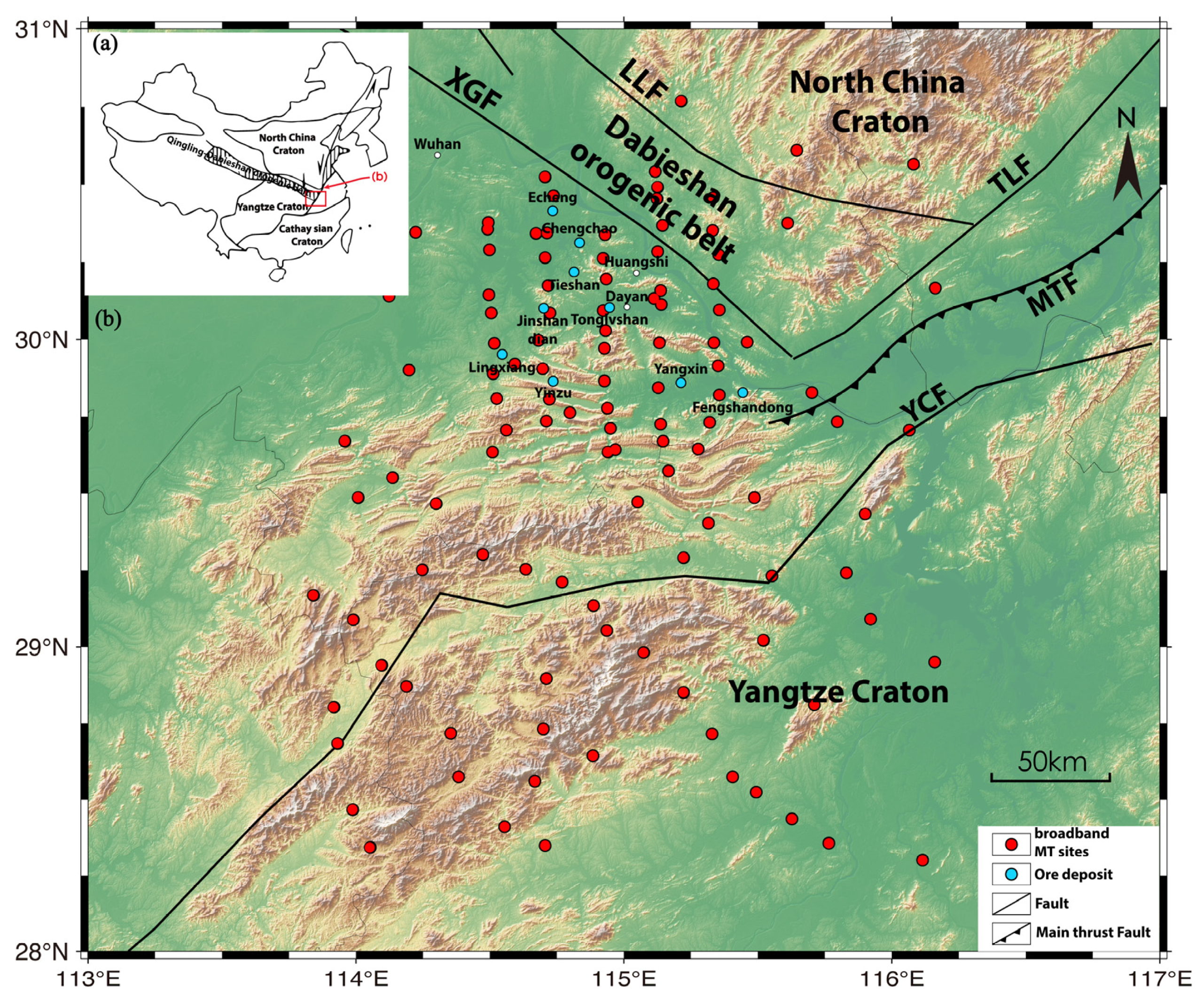
2. Geological and Geophysical Background
- Large- and medium-sized skarn-type iron and copper deposits, such as Jinshandian, Chengchao, Tieshan, and Tonglushan deposits, were formed. These deposits are characterized by silicate-carbonate rocks and host significant iron and copper mineralization.
- Silicate-carbonate and porphyry-type copper-molybdenum deposits, such as Fengshandong, were generated. These deposits are associated with intrusive rocks and are rich in copper and molybdenum mineralization.
- Magmatic-hydrothermal and volcanic-hydrothermal iron and copper polymetallic deposits were formed. These deposits resulted from the interaction between magmatic and hydrothermal fluids associated with volcanic activities.
- Copper-iron deposits are influenced by the distribution of magmatic rocks. The deposits are closely associated with intrusive bodies, and the main distribution area is in the contact zone between Mesozoic intermediate-acidic igneous rocks and carbonate sandstone shale. Some deposits are also found in the residual bodies and xenoliths of carbonate rocks.
- Copper-iron deposits are distributed along the Ezhou-Damushan superimposed folding zone. Along the EW direction, the deposits can be divided into iron ore deposits, copper-iron ore deposits, and copper (tungsten, molybdenum) mineralization belts.
3. Data Collection, Processing, and Analysis
3.1. MT Data Acquisition and Processing
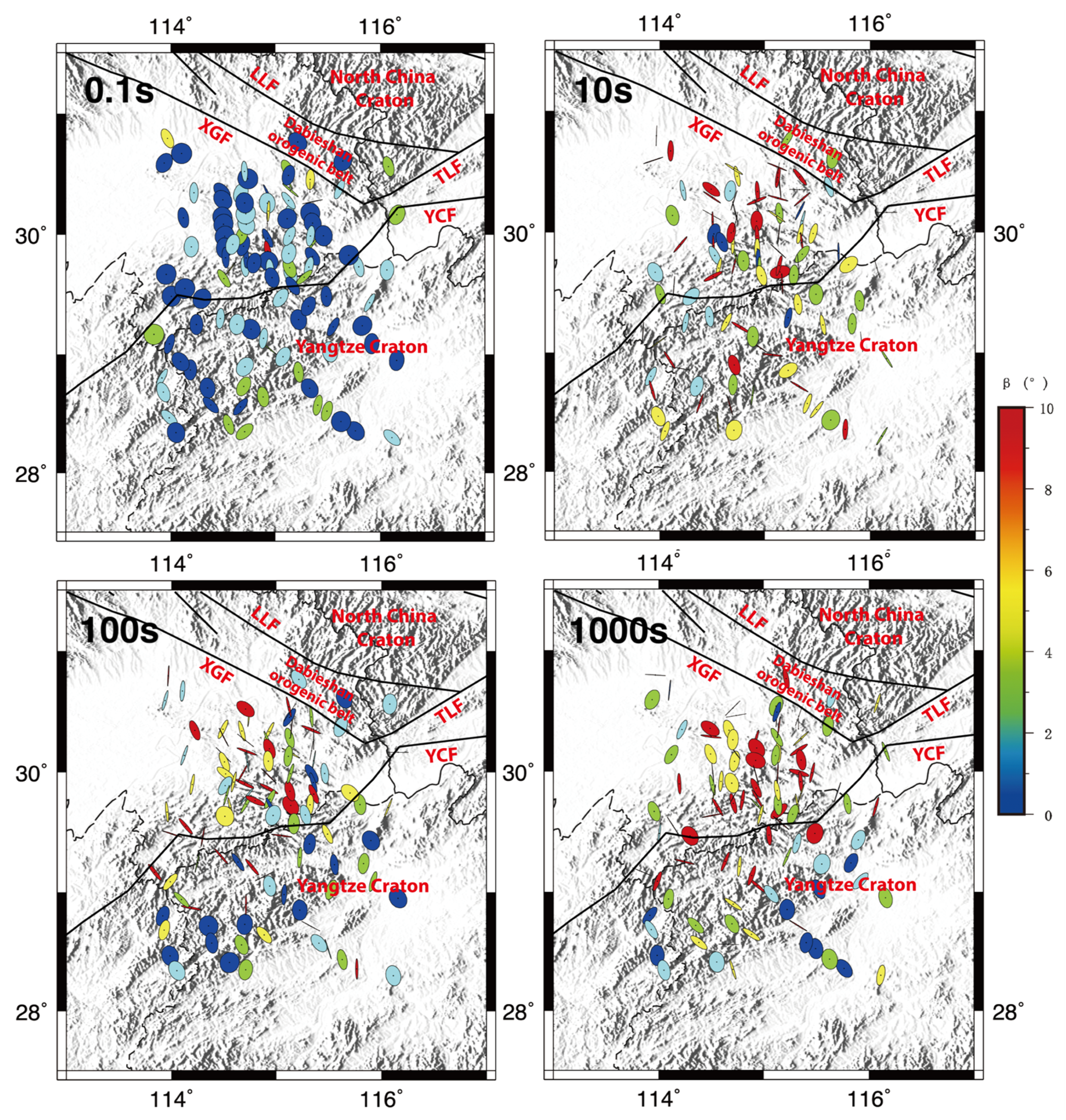
3.2. Data Analysis
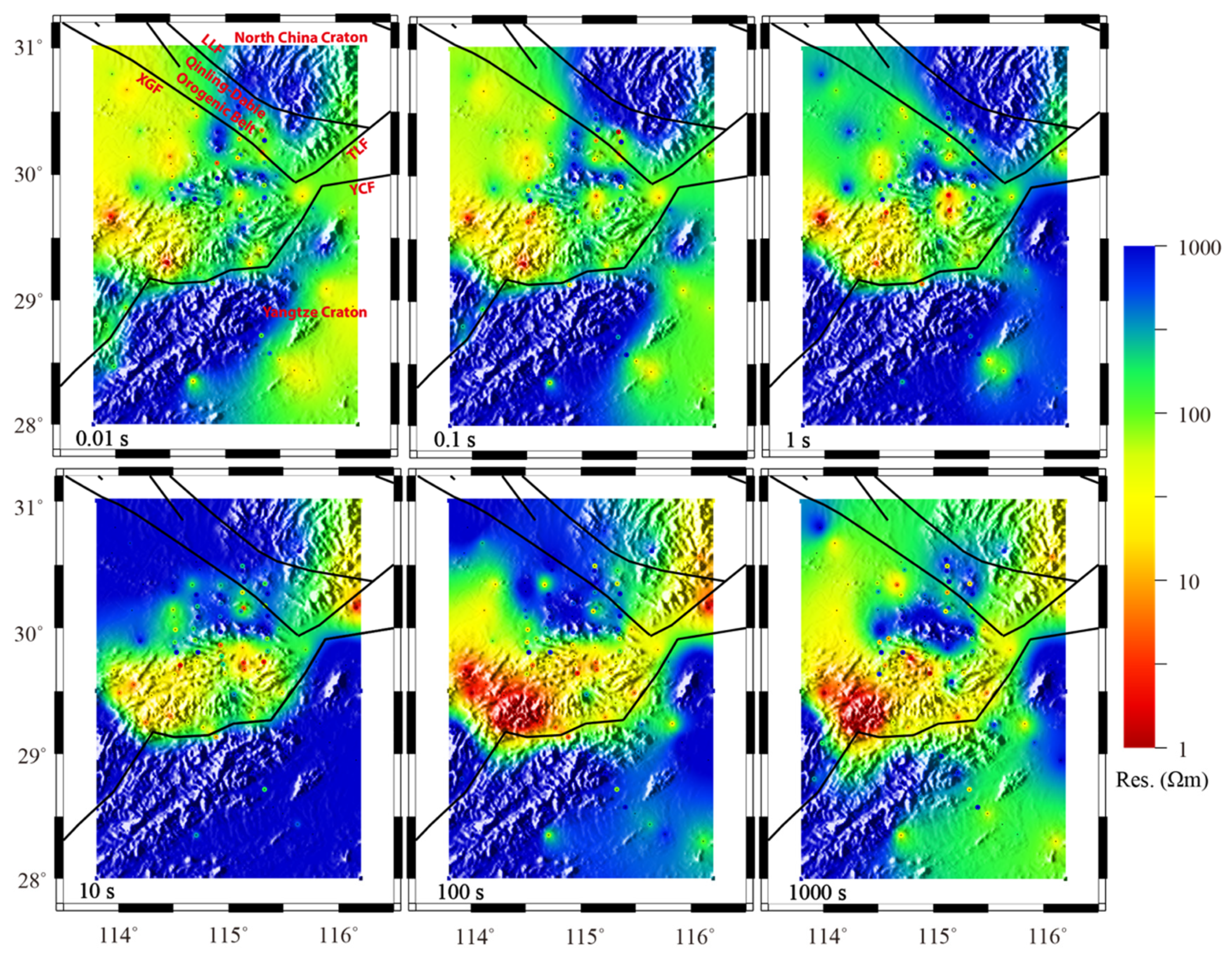
3.3. 3D Inversions
4. Interpretation and Discussion
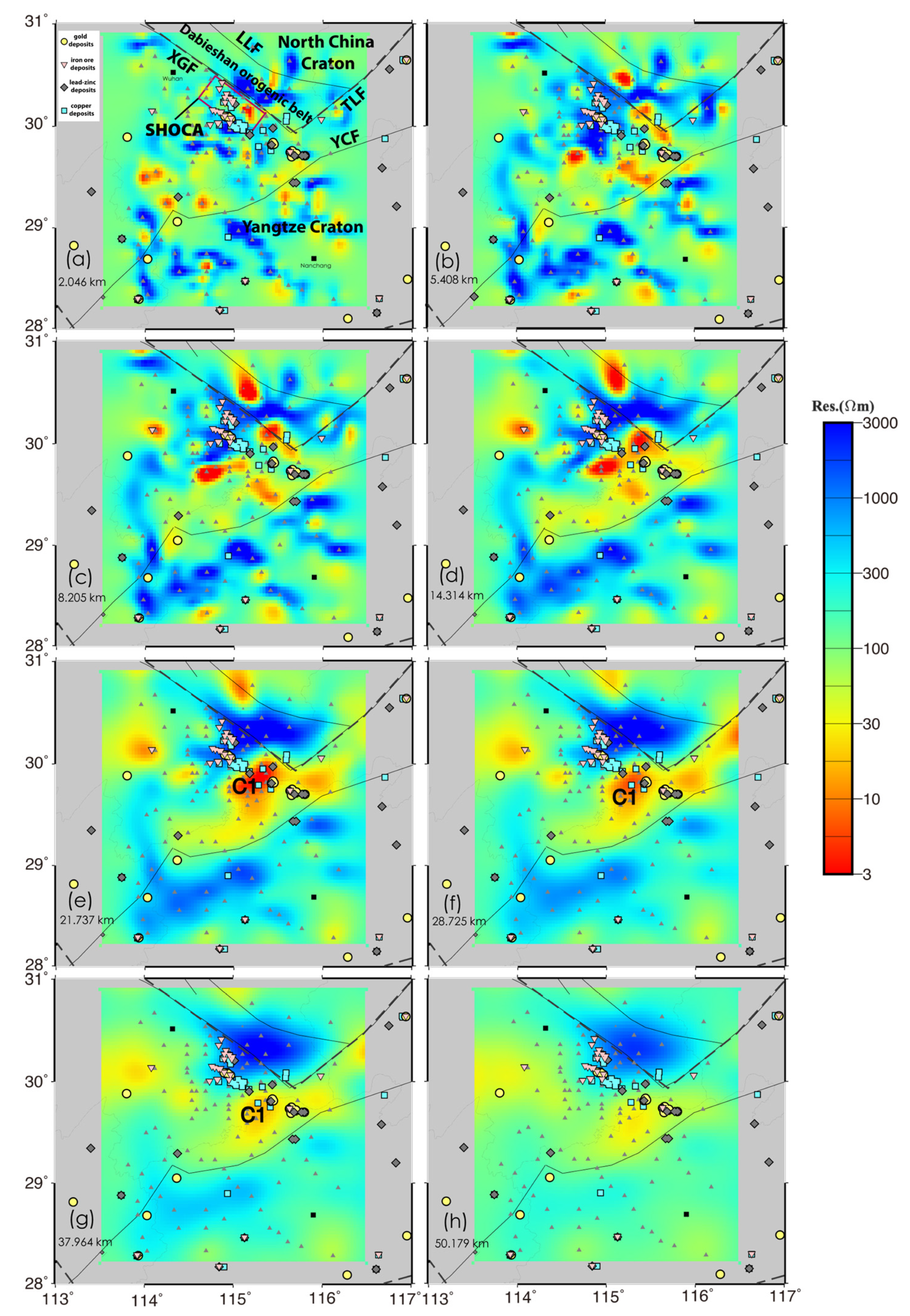
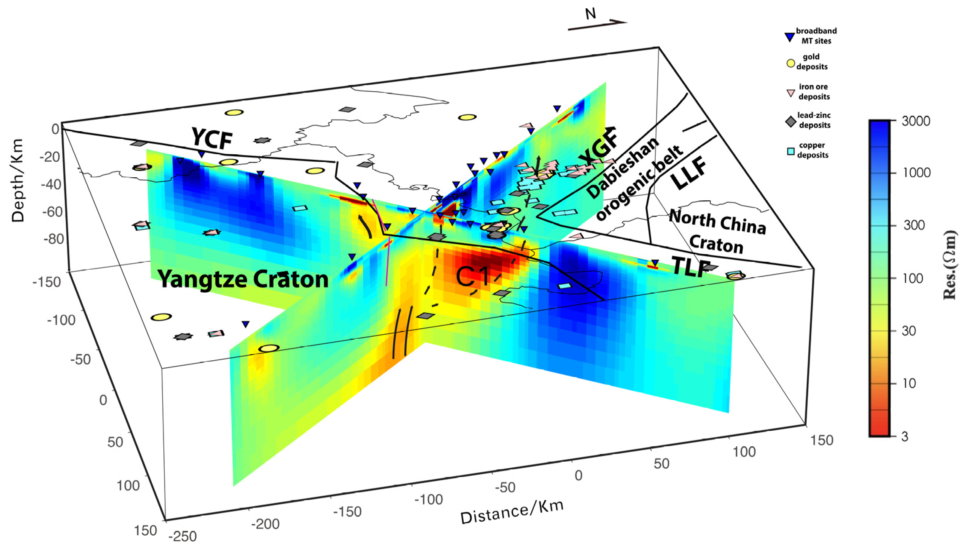
4.1. The Composition of Crustal Materials
4.2. The Deep-Seated Background of the Magma-Mineral System
5. Conclusions
- The high-conductivity anomaly in the middle and lower crust of the metallogenic belt indicates the occurrence of partial melting and crust–mantle material mixing in the subsurface. During the Indonesian to early Yanshanian period, plate collisions and subsequent intracontinental subduction events occurred under compressional stress, resulting in metamorphic deformation and dehydration melting of the upper crustal rocks of the subducting plate. In the late Yanshanian period, deep-seated materials upwelled and mixed with the crust under the extensional stress regime, forming primary ore-forming magmas through the MASH process. This is reflected in the electrical structure model as the widespread high-conductivity anomaly C1.
- The major faults in the study area, including the Tancheng-Lujiang Fault, the Yangxin-Changzhou Fault, and the Xiangfan-Guangji Fault, are manifested as boundaries between high and low resistivity in the electrical structure model. They are connected to the high-conductivity anomaly C1 in the middle and lower crust of the study area. These faults serve as pathways for the upward migration of deep-seated hydrothermal fluids and control the distribution of shallow mineral deposits. The deep-source elements in various ore clusters of the middle and lower Yangtze River Metallogenic Belt are inferred to have a certain degree of homogeneity.
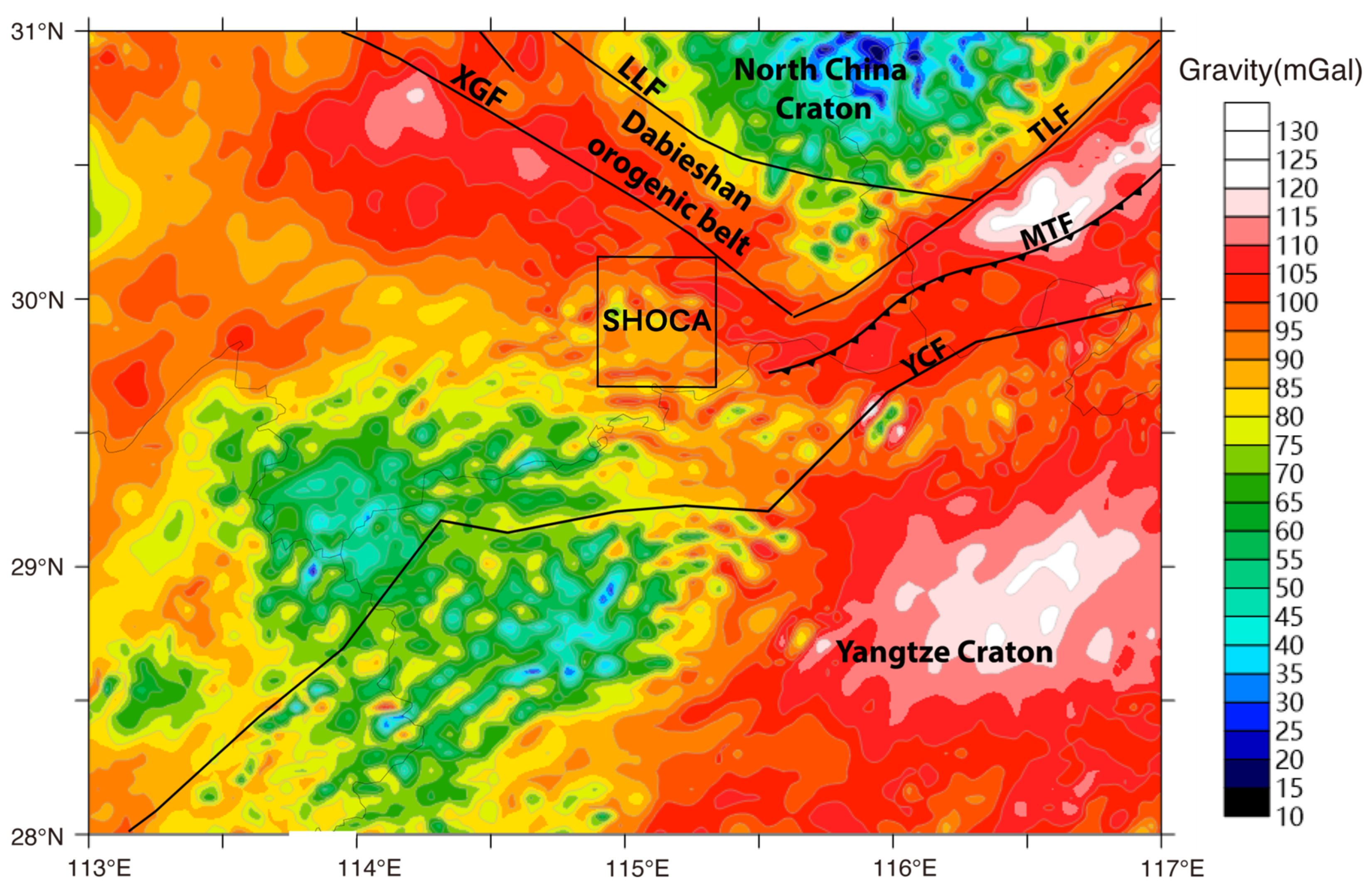
- By analyzing the resistivity model and integrating it with the Bouguer gravity and aeromagnetic anomalies in the study area, we conclude that the Xiangfan-Guangji Fault is a crustal-scale fault.
Supplementary Materials
Author Contributions
Funding
Data Availability Statement
Acknowledgments
Conflicts of Interest
References
- Chang, Y.F.; Liu, X.P.; Wu, Y.C. The Copper–Iron Belt of the Middle and Lower Reaches of the Changjiang River; Geological Publishing House: Beijing, China, 1991. [Google Scholar]
- Lü, Q.T.; Hou, Z.Q.; Yang, Z.S.; Shi, D.N. Underplating and dynamical model of the Middle-Lower Reaches of Yangtze River belt; Constraints from geophysical data. Sci. China Earth Sci. 2004, 34, 783–794. [Google Scholar]
- Wang, Q.; Zhao, Z.H.; Xiong, X.L.; Xu, J.F. Melting of the underplated basaltic lower crust: Evidence from the Shaxi adakitic sodic quartz diorite-porphyrites, Anhui Province, China. Geochimica 2001, 30, 353–362. [Google Scholar]
- Zhou, T.F.; Yu, F.; Yuan, F. Advances on petrogensis and metallogeny study of the mineralization belt of the Middle and Lower Reaches of the Yangtze River area. Acta Petrol. Sin. 2008, 24, 1665–1678. [Google Scholar]
- Deng, J.F.; Wu, Z.X. Lithospheric Thinning Event in the Lower Yangtze Craton and Cu-Fe Metallogenic Belt in the Middle and Lower Yangtze River Reaches. Geol. Anhui 2001, 2, 86–91. [Google Scholar]
- Chen, B.; Liu, C.Q.; Tian, W. Magma-mixing between mantle- and crustal-derived melts in the process of Mesozoic magnmtism, Taihangshan: Constraints from petrology and geochemistry. Earth Sci. Front. 2006, 13, 140–147. [Google Scholar]
- Shi, D.; Lu, Q.; Xu, W.; Yan, J.; Zhao, J.; Dong, S.; Chang, Y. Crustal Structures Beneath the Mid-Lower Yangtze Metallogenic Belt and Its Adjacent Regions in Eastern China-Evidences from P-Wave Receiver Function Imaging for a MASH Metallization Process? Acta Geol. Sin. 2012, 86, 389–399. [Google Scholar]
- Sheng, Y.; Jin, S.; Liang, H.; Wei, W.; Ye, G.; Lu, Z. Electrical Structure of Narusongduo Ore Concentration District and Its Constraints on Mineralization. Earth Sci. 2019, 44, 2106–2116. [Google Scholar]
- Wei, W.; Jin, S.; Ye, G.; Deng, M.; Jing, J.; Unsworth, M.; Jones, A.G. Conductivity structure and rheological property of lithosphere in Southern Tibet inferred from super-broadband magnetotelluric sounding. Sci. China Earth Sci. 2010, 53, 189–202. [Google Scholar] [CrossRef]
- Zhang, L.-T.; Jin, S.; Wei, W.-B.; Ye, G.-F.; Duan, S.-X.; Dong, H.; Zhang, F.; Xie, C.-L. Electrical structure of crust and upper mantle beneath the eastern margin of the Tibetan plateau and the Sichuan basin. Chin. J. Geophys. 2012, 55, 4126–4137. [Google Scholar]
- Zhang, K.; Lu, Q.T.; Man, Z.H.; Lan, X.Y.; Guo, D.; Tao, L.; Zhao, J.H. Electrical constraints on the deep setting and process of magma-mineral system in the Middle-Lower Reaches of Yangtze Metallogenic Belt. Acta Petrol. Sin. 2022, 38, 573–583. [Google Scholar] [CrossRef]
- Xia, J.; Huang, G.; Ding, L. Metallogenic Regularity of Iron-Copper Polymetallic Deposits in the Southeastern Hubei Province. Miner. Depos. 2012, 31, 51–52. [Google Scholar]
- Hu, Q.L. The Mesozoic Diagenetic & Metallogenic Tectonic Background and the Temporal & Spatial Distribution in the Southeast of Hubei Province. Resour. Environ. Eng. 2014, 28, 767–776. [Google Scholar]
- Xue, D.; Ge, Z.; Hu, H. Metallogenic Model and Prospecting Model of Copper-Gold Deposits in Southeastern Hubei; China University of Geosciences Press: Wuhan, China, 1997. [Google Scholar]
- Dong, S.; Ma, L.; Liu, G.; Xue, H.; Shi, W.; Li, J. On dynamics of the metallogenic belt of Middle-Lower Reaches of Yangtze River, eastern China. Acta Geol. Sin. 2011, 85, 612–625. [Google Scholar]
- Xie, G.; Zhu, Q.; Yao, L.; Wang, J.; Li, W. Discussion on Regional Metal Mineral Deposit Model of Late Mesozoic Cu-Fe-Au Polymetallic Deposits in the Southeast Hubei Province. Bull. Mineral. Petrol. Geochem. 2013, 32, 418–426. [Google Scholar]
- Zhou, A.; Zhang, G.; Xu, L.; Wang, P.; Xia, L. Inference of Concealed Intrusion and Its Prospecting Potential in Southeast Hubei. Resour. Environ. Eng. 2013, 6, 81–85. [Google Scholar]
- Zhang, G. Structural Characteristics and Rock-Mineralization Control Laws in Southeast Hubei Region. Resour. Environ. Eng. 1998, 2, 16–23. [Google Scholar]
- Gao, B. Study on Deep Background and Geophysical Characteristics of Mineralization in Southeast Hubei Mining District. Ph.D. Thesis, China University of Geosciences, Wuhan, China, 2021. [Google Scholar]
- Houze, X. Satellite gravity missions-newhotpointin geodesy. Sci. Surv. Mapp. 2001, 26, 1–3. [Google Scholar]
- Zhang, C. Deduction of magnetic characteristics of lithosphere in China from results on satellite and aeromagnetic measurements. Prog. Geophys. 2003, 18, 103–110. [Google Scholar]
- Egbert, G.D.; Booker, J.R. Robust estimation of geomagnetic transfer functions. Geophys. J. R. Astron. Soc. 2010, 87, 173–194. [Google Scholar] [CrossRef]
- Gamble, T.D.; Goubau, W.M.; Clarke, J.J.G. Magnetotellurics with a remote magnetic reference. Geophysics 1979, 44, 53–68. [Google Scholar] [CrossRef]
- Caldwell, T.G.; Bibby, H.M.; Brown, C. The magnetotelluric phase tensor. Geophys. J. Int. 2004, 158, 457–469. [Google Scholar] [CrossRef]
- Booker, J.R. The Magnetotelluric Phase Tensor: A Critical Review. Surv. Geophys. 2014, 35, 7–40. [Google Scholar] [CrossRef]
- Kelbert, A.; Meqbel, N.; Egbert, G.D.; Tandon, K.J.C. ModEM: A modular system for inversion of electromagnetic geophysical data. Comput. Geosci. 2014, 66, 40–53. [Google Scholar] [CrossRef]
- Wang, Q.; Xu, J.; Zhao, Z.; Xiong, X.; Bao, Z. Petrogenesis of the Mesozoic intrusive rocks in the Tongling area, Anhui Province, China and their constraint on geodynamic process. Sci. China Ser. D 2003, 46, 801–815. [Google Scholar] [CrossRef]
- Zhou, T.F.; Wang, S.W.; Yuan, F.; Fan, Y.; Zhang, D.Y.; Chang, Y.F.; White, N.C. Magmatism and related mineralization of the intracontinental porphyry deposits in the Middle-Lower Yangtze River Valley Metallogenic Belt. Acta Petrol. Sin. 2016, 32, 271–288. [Google Scholar]
- Zhang, Y.; Shi, D.; Lü, Q.; Xu, Y.; Xu, T. The crustal thickness and composition in the eastern South China Block constrained by receiver functions: Implications for the geological setting and metallogenesis. Ore Geol. Rev. 2021, 130, 103988. [Google Scholar] [CrossRef]
- Bedrosian, P.A.; Peacock, J.R.; Dhary, M.; Sharif, A.; Feucht, D.; Zahran, H. Crustal magmatism and anisotropy beneath the Arabian shield—A cautionary tale. J. Geophys. Res. Solid Earth 2019, 124, 10153–10179. [Google Scholar] [CrossRef]
- Bettac, S.P.; Unsworth, M.J.; Pearson, D.G.; Craven, J. New constraints on the structure and composition of the lithospheric mantle beneath the Slave craton, NW Canada from 3-D magnetotelluric data–Origin of the Central Slave Mantle Conductor and possible evidence for lithospheric scale fluid flow. Tectonophysics 2023, 851, 229760. [Google Scholar] [CrossRef]
- Lu, Q.; Meng, G.; Yan, J.; Zhang, K.; Gong, X.; Gao, F. The geophysical exploration of Mesozoic iron-copper mineral system in the Middle and Lower Reaches of the Yangtze River Metallogenic Belt: A synthesis. Earth Sci. Front. 2020, 27, 232–253. [Google Scholar]
- Kolb, J. The role of fluids in partitioning brittle deformation and ductile creep in auriferous shear zones between 500 and 700 °C. Tectonophysics 2008, 446, 1–15. [Google Scholar] [CrossRef]
- Xue, D. Triangular Tectonic Pattern and Its Significance in the Geological Structure of Southeast Hubei. Resour. Environ. Eng. 2013, 27, 4–6. [Google Scholar]
- Song, C.Z.; Lin, S.F.; Zhou, T.F.; Yan, J.; Ren, S.L.; Li, J.H.; Tu, W.C.; Zhang, Y. Mesozoic tectonic regime transition of the Middle and Lower Reaches of the Yangtze River and its adjacent area. Acta Petrol. Sin. 2010, 26, 2835–2849. [Google Scholar]
- Lu, Q.T.; Dong, S.W.; Tang, J.T.; Shi, D.N.; Chang, Y.F.; SinoProbe, C.J.G. Multi-scale and integrated geophysical data revealing mineral systems and exploring for mineral deposits at depth A synthesis from SinoProbe-03. Chin. J. Geophys. Chin. Ed. 2015, 58, 4319–4343. [Google Scholar] [CrossRef]
- Zheng, Y.F.; Chen, Y.X.; Dai, L.Q.; Zhao, Z.F. Developing plate tectonics theory from oceanic subduction zones to collisional orogens. Sci. China Sci. Sin. 2015, 25, 711–735. [Google Scholar] [CrossRef]
- Xu, J.F.; Shinjo, R.; Defant, M.J.; Wang, Q.; Rapp, R.P. Origin of Mesozoic adakitic intrusive rocks in the Ningzhen area of east China: Partial melting of delaminated lower continental crust? Geology 2002, 30, 1111–1114. [Google Scholar] [CrossRef]
- Lu, Q.; Shi, D.; Liu, Z.; Zhang, Y.; Dong, S.; Zhao, J. Crustal structure and geodynamics of the Middle and Lower reaches of Yangtze metallogenic belt and neighboring areas: Insights from deep seismic reflection profiling. J. Asian Earth Sci. 2015, 114, 704–716. [Google Scholar] [CrossRef]
- Lu, Q.; Yan, J.; Shi, D.; Dong, S.; Tang, J.; Wu, M.; Chang, Y. Reflection seismic imaging of the Lujiang–Zongyang volcanic basin, Yangtze Metallogenic Belt: An insight into the crustal structure and geodynamics of an ore district. Tectonophysics 2013, 606, 60–77. [Google Scholar] [CrossRef]

Disclaimer/Publisher’s Note: The statements, opinions and data contained in all publications are solely those of the individual author(s) and contributor(s) and not of MDPI and/or the editor(s). MDPI and/or the editor(s) disclaim responsibility for any injury to people or property resulting from any ideas, methods, instructions or products referred to in the content. |
© 2024 by the authors. Licensee MDPI, Basel, Switzerland. This article is an open access article distributed under the terms and conditions of the Creative Commons Attribution (CC BY) license (https://creativecommons.org/licenses/by/4.0/).
Share and Cite
Xu, D.; Zhang, Y.; Tang, B.; Yan, G.; Ye, G.; Dong, J.; Liu, B.; Zhang, Y. Three-Dimensional Electrical Structure and Metallogenic Background of the Southeastern Hubei Ore Concentration Area. Minerals 2024, 14, 558. https://doi.org/10.3390/min14060558
Xu D, Zhang Y, Tang B, Yan G, Ye G, Dong J, Liu B, Zhang Y. Three-Dimensional Electrical Structure and Metallogenic Background of the Southeastern Hubei Ore Concentration Area. Minerals. 2024; 14(6):558. https://doi.org/10.3390/min14060558
Chicago/Turabian StyleXu, Daili, Yiwu Zhang, Baoshan Tang, Guolong Yan, Gaofeng Ye, Ji’en Dong, Bo Liu, and Yiming Zhang. 2024. "Three-Dimensional Electrical Structure and Metallogenic Background of the Southeastern Hubei Ore Concentration Area" Minerals 14, no. 6: 558. https://doi.org/10.3390/min14060558