Article

Hydroclimate and Paleoenvironmental Variability from the Tonle Sap Lake Basin during the Angkor Period

1
School of Geography and Tourism, Huizhou University, Huizhou 516007, China
2
Institute of Global Environmental Change, Xi’an Jiaotong University, Xi’an 712000, China
3
Center for Cambodian Studies, Jiujiang University, Jiujiang 332005, China
*
Author to whom correspondence should be addressed.
Minerals 2024, 14(6), 581; https://doi.org/10.3390/min14060581
Submission received: 9 April 2024 / Revised: 23 May 2024 / Accepted: 24 May 2024 / Published: 31 May 2024
(This article belongs to the Special Issue Stalagmite Geochemistry and Its Paleoenvironmental Implication)

Abstract

:
The profound impact of the Khmer Empire on Southeast Asia renders the Angkor Period particularly significant in guiding contemporary societies to advocate and promote policies that respond to climate change. We present a new continuous multi-proxy speleothem dataset from Tonle Sap Lake Basin, investigating hydroclimate variability and the paleoenvironment of Cambodia during the Angkor Period from the 9th to 15th centuries. In addition, two important climatic events on a decadal scale are clearly reconstructed. The first is the reduction of precipitation between 800 and 1000 AD and the relatively significant drought that the regional environment may have experienced from 950 to 1000 AD. The second is the anomalous wet period between 1000 and 1200 AD, during which the Southern Oscillation Index also reached its negative peak after a thousand years. The wet and dry conditions are highly consistent with the El Niño-dominated and northward Intertropical Convergence Zone.

1. Introduction

Extreme weather has become an important factor affecting social development in the Asian monsoon region, and the causes of extreme weather have become a social focus of common concern for the public. The Khmer Empire, which flourished in mainland Southeast Asia between 802 and 1431 AD [1], also named the Angkor Period, is a typical case of social development affected by climate and environmental change. Based on the profound impact of the Khmer Empire on Southeast Asian societies, the climate and paleoenvironment during the 9th to 15th centuries carry special significance when guiding contemporary Southeast Asian societies on how to cope with climate change, for example, by calling the attention of the population to climate change and the dissemination and promotion of related policies.
Hence, the rise and fall of the Khmer Empire and its climate-related causes have been issues of common concern in many fields for the past decade, including paleoclimate research in Cambodia [2], Vietnam [3,4], Laos [5], and Thailand [6,7], paleoenvironmental research in Angkor Wat [8] and the surrounding areas [9,10,11], and archaeology [12,13,14]. In particular, a considerable amount of research has been devoted to clarifying the main climatic factors and control patterns responsible for droughts during the Angkor Period. In this region, unlike the consensus that the orbital scale is dominated by the strength of the monsoon [15], the climate mechanism at the centennial scale remains questionable. For millennium-scale climate events, the latest study suggests that vegetation–dust climate feedback from the Sahara as it becomes drier may have been the catalyst for societal shifts in mainland Southeast Asia via ocean–atmospheric teleconnections [16]. On a centennial to decadal scale, conventional theory suggests that the weakening of the Indian monsoon will result in a decrease in precipitation over most of Asia [3,4,5]. Newer studies emphasize the control of climate in near-equatorial regions due to factors such as the migrations of the Intertropical Convergence Zone (ITCZ) and El Niño-Southern Oscillation teleconnection [6]. Due to this complexity, our current understanding of hydroclimate changes during the 9th to 15th centuries AD is still limited. Therefore, robust temporal and spatial hydroclimate records from the Tonle Sap Lake Basin (TSLB) are important, as they will allow us to better understand the regional variability of hydroclimate and paleoenvironment.
We reconstruct a continuous speleothem record of multiple proxies for Mainland Southeast Asia, which is based on two replicated stalagmites from TSLB, Cambodia, and compare it with other paleoclimate records to address the issues.

2. Materials and Methods

2.1. Study Area and Sampling

The study area is in the Battambang province of Cambodia (13°18′ N, 102°28′ W). The sampling site is about 120 km away from the Angkor Wat site and is also the site of Laang Spean cave [17], Cambodia’s most important Holocene paleoanthropological site. The sampled cave (H5) is located in the Cardamom Mountains in western Cambodia. The bedrock of the cave was judged to be Carboniferous (C1) based on the mineral and geological map of Battambang (2009) as well as fossils of a sea lily found during the cave expedition. The cave is about 1577 m long, and the narrowest section is less than 1 m. The average elevation of the caves is 230 m, which is higher than the local surface water level. No underground river has been found in the cave, and the karst water in the cave is completely controlled by local atmospheric precipitation.
The northern part of Mainland Southeast Asia is the extension of the Tibetan Plateau, while the southern narrow isthmus is the watershed between the Indian and Pacific Oceans. Therefore, the local climate and environment could be considered in three geographical units. From north to south, they are the plateau area in the north, with an average altitude of over 1200 m; the flood plain of the Tonle Sap Lake with the Mekong River in the center (10.5°–14.2° N, 102.5°–107.5° W), and the Isthmus of Kra in the south. The ITCZ moves seasonally in the region and is an important factor in controlling local precipitation (Figure 1).

2.2. 230Th-U Dating and Microlayer Count Method

Stalagmites H5-1 and H5-2 were collected by the author during cave exploration. After cutting along the growth axis and polishing, H5-1 and H5-2 had distinct horizontal depositional growth layers, with sample H5-2 having bright–dark coupled laminas visible to the naked eye. The length of stalagmite H5-1 is about 153 mm, and its diameter ranges from 30 to 50 mm. The length of stalagmite H5-2 is about 112 mm, and its diameter ranges from 30 to 50 mm. A total of 6 and 5 samples were obtained for 230Th-U dating of H5-1 and H5-2, respectively (Table S1). All dating work was performed at the Institute of Global Environmental Change of Xi’an Jiaotong University (China), using the same method as described in Edwards et al. (1987) and Cheng et al. (2013) [21,22]. The bright–dark coupled laminae of the H5-2 sample were counted using an ordinary light microscope. The results, which were counted independently by different people, were corrected with the 230Th-U age.

2.3. Stable Isotope and Trace Element Analysis

Subsamples for stable isotope analysis were drilled by hand using a 0.3 mm diameter drill bit; the average sample interval was 1 mm. The stable isotope composition of the samples was measured using Thermo Fisher Scientific (Waltham, MA, USA) Isotope-Ratio Mass Spectrometry (MAT253). The results are reported relative to the Vienna Pee Dee Belemnite (VPDB) standard with an average 2σ uncertainty of 0.1‰ or less. All stable isotope testing work was performed at the Institute of Global Environmental Change of Xi’an Jiaotong University (China), using the same method as described in Cheng et al. (2009) [23].
Trace element ratios were tested using an Ocean Optics AC-CULIBS2500 integrated laser-induced breakdown spectrometer. The ACCULIBS2500 performs automated scanning of the sample for trace elements at various locations on an automated platform with an automated control system for protective gases. The wavelength range of the test was 180 nm–1100 nm, the optical resolution was 0.1 nm, and all other settings were the default parameters of the system. Trace elements were measured using two sampling densities, 1 mm and 5 mm intervals, to check the reliability of the measurements.

3. Results

3.1. Chronology Model

Sample H5-1 has 6 230Th-U ages (Table S1), with errors ranging from ±70 to ±180 year and a mean age error of ±105 year, with bottom to top ranging from 760 ± 100 to 1840 ± 70 year AD. The age model of H5-1 is calculated by Mod-age [24]. For sample H5-2, 5 230Th-U ages (Table S1) were obtained; except for the top, which has an age error of ±130 year, the other 4 have a mean age error of ± 60 year. Thus, sample H5-2 has bottom to top ranging from 1380 ± 70 to 1630 ± 130 year AD. Overall, the average initial enrichment of 238U for the two samples was 200 ppb, while the average ratio of 230Th/238U was 0.001, resulting in an average dating error of 106 years for the two samples. To further improve the age accuracy, this study reconstructed a relative age model based on the bright–dark coupled laminae of H5-2. Independent counts by different individuals for sample H5-2 show bright–dark coupled laminae of 235 ± 13 year, which is close to the ~250 year deposition time indicated by the 230Th-U ages. The bright–dark coupled laminae of H5-2 were therefore judged to be the annual laminae, and a relative age model was developed. The age model of sample H5-2 ranges from 1455 ± 20 to 1690 ± 20 year AD (rounding up of ±13 year) (Figure 2).
Previous studies have argued for the consistency of stalagmite oxygen isotopes in this region with the stalagmite records from India and southwest China [3,4,5], while again demonstrating the relatively prominent temporal and spatial consistency of oxygen isotopes within the monsoon region on a centennial to millennial scale. Hence, the oxygen isotope record was used as an age-tuning scale in this study. Without exceeding the 230Th-U age error range, by using the extreme values in the oxygen isotope record as a reference (−6.2‰ and −4.9‰ for H5-1 and H5-2, respectively), the age of the H5-1 record was tuned to be consistent with H5-2 (Figure 3a).

3.2. Interpretation of the Stalagmite δ18O, δ13C, and Trace Element Records
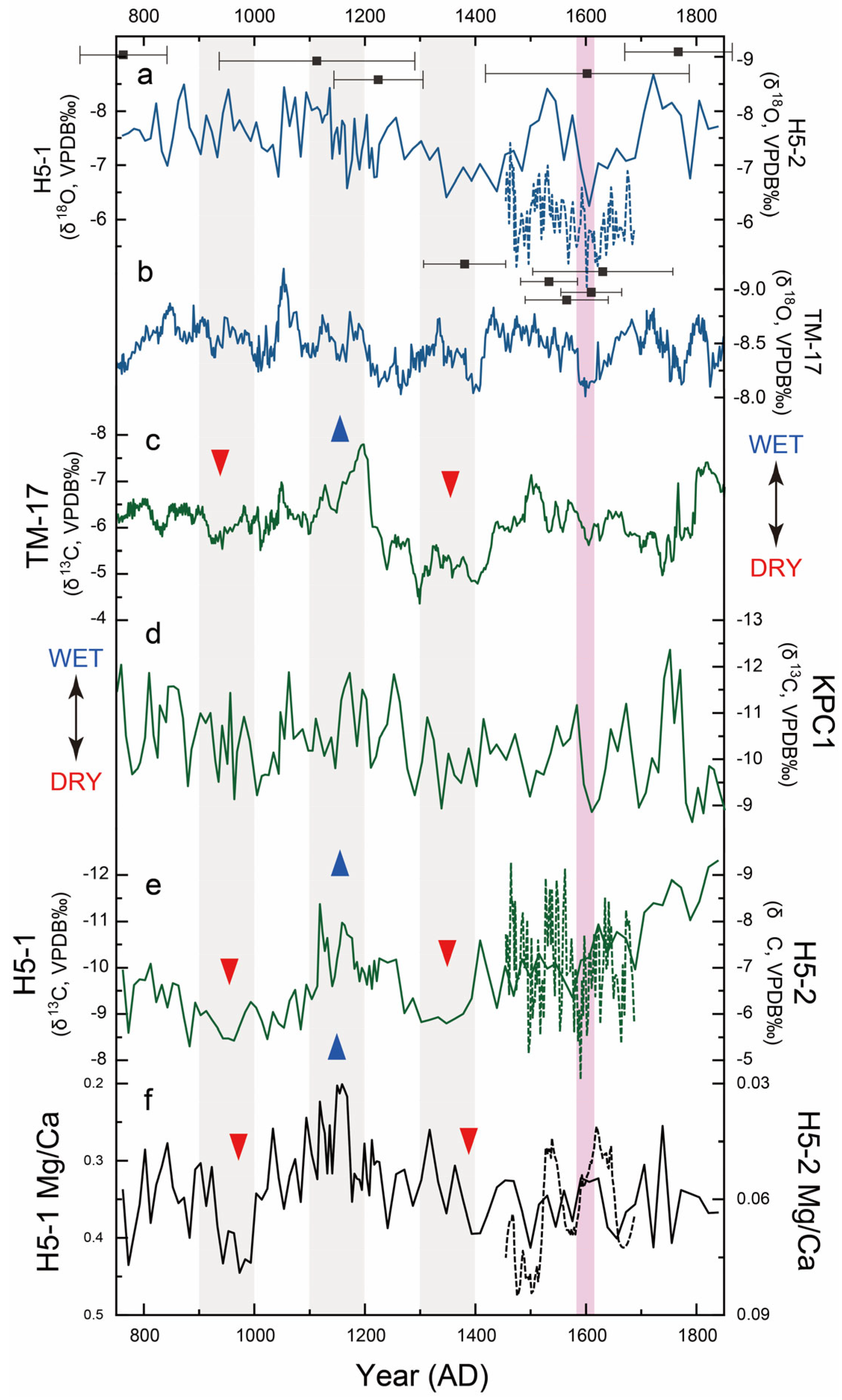
Stalagmite δ18O in Mainland Southeast Asia has long been recognized as an indicator of the strength of the Indian monsoon [5,7,9]; the reconstructed records are relatively reproducible in terms of both space and time. However, the speleothem δ13C values have long been thought to be controlled by a variety of processes at cave sites, including the composition of C3/C4 plants [25] and vegetation density [26], karst geology and hydrology [27], and changes in atmospheric CO2 isotopic composition and biological CO2 derived from root respiration and microbial activity [28]. A recent comprehensive study based on the analysis of a large global dataset of records reveals evidence for indirect temperature control driven by vegetation and soil processes [29,30]. In summary, the climatic and environmental significance of stalagmite carbon isotopes is complex and diverse. For this reason, many previous stalagmite studies have generally focused on oxygen isotopes only, ignoring carbon isotopes. In this study, considering that the regular and straight morphology and columnar fabric of the samples (Figure 2), indicative of a fixed and continuous dripping point in the cave [31], we infer that the δ13C increases were mainly driven by climate-related soil and vegetation processes associated with drier conditions [32].
Additionally, carbon isotope variations of H5-1 stalagmites have an amplitude of 4‰ and a range of −8.3 to −12.3‰ over the period from the 9th to the 15th centuries AD. In contrast to the Shan Plateau stalagmites, TM-17, the two records have consistent carbon isotope variations of −4.01 and −4.07‰, respectively, and the course of the recorded variations is very similar. The δ13C values of TM-17 are interpreted as a local water balance record [5]. Stalagmite KPC1 from Thailand also recorded the same amplitude of 4‰ during the last 1400 years [7]. However, this record is more muted compared to TM-17 and to H5-1 reconstructed in this study. This may be related to the high level of impurities in the KPC1 sample, which is also supported by the U-Th dating age error of this sample. Despite the discrepancies, the δ13C record of KPC1 is generally consistent with paleoenvironmental processes in western Thailand and has also been used as an indicator of wet and dry conditions. There is a negative δ13C variation of KPC1 compared with H5-1 after 1400 AD, a process which is not present in TM-17 from the northern part of the Shan Plateau (Figure 3).
In addition to the cross-validation of stalagmite δ13C in the Indochina Peninsula, Mg/Ca ratios of H5-1 stalagmites demonstrate similar trends. Many previous studies have discussed the pCO2 degassing mechanism of trace element ratios in wet and dry conditions in karst hydrological environments [33], and cave monitoring in China [34] and the nearby stalagmite study [7] have confirmed the correlation between trace elements and local precipitation on a centennial scale.
Figure 3. Speleothem records during the Angkor Period from Mainland Southeast Asia. (a) Stalagmite δ18O (VPDP, ‰) records of H5-1 with H5-2 from this research and (b) δ18O record of TM-17 [5]. The H5-1 record was tuned to H5-2 so that the extreme value of oxygen isotopes in the H5-1 record (−6.2‰) has an age around 1600 AD (pink shadow). (c) to (e) are stalagmite δ13C (VPDP‰) records of TM-17 [5], KPC1 [7], and H5-1 with H5-2, respectively. (f) shows the Mg/Ca ratios of H5-1 with H5-2. Stalagmite δ13C values and Mg/Ca ratios mark one wet (blue triangle) and two dry (red triangle) periods.
Minerals 14 00581 g003
In summary, we reconstructed the very first record of environmental wet and dry conditions of the TSLB from the 9th to 15th centuries AD based on a multi-indicator stalagmite record (Table S2). This study is based on record reconstruction to carefully portray the evolution of the environment in the ancient Cambodian region.

4. Discussion

The intensity of the Indian monsoon, as indicated by stalagmite δ18O, exhibits repeated oscillations on a centennial scale, with no clear trend that parallels the δ13C or Mg/Ca ratios (Figure 3). Therefore, based on the δ13C records, we divided the hydroclimate and Paleoenvironmental during the Angkor Period (according to historical documents, from 802 to 1431 AD) into three phases, from old to new (Figure 4). The first phase, spanning 800 to 1100 AD, was identified as an unstable environment. The second phase, from 1100 to 1200 AD, was characterized by anomalous wet conditions. Finally, the third phase, spanning 1200 to 1500 AD, was identified as an extreme weather period, characterized by extensive flooding and drought in the late 14th century, a period that confirmed the role of climate in the decline of the Khmer Empire [3,4,5,6].

4.1. Drought Event from the Early Angkor Period

The new finding of this study is that reduced precipitation and severe drought also existed in the early Angkor period (Figure 4). In the δ13C and Mg/Ca records reconstructed for this study, the drought experienced in the TSLB around 950 to 1000 AD was of roughly the same magnitude or even lower than that at the end of the Angkor Period (Figure 4c,d), during which period previous studies have identified drought and floods that may have been associated with the decline of the Angkor [2,3,4,5,6,7,8]. Furthermore, the drought event that occurred between 950 and 1000 AD coincided with the reign of Jayavarman V (968–1000 AD) and his unfinished funerary temple, the Ta Keo temple [35]. The unfinished temple may have been affected by the drought conditions that prevailed at the time.
In terms of regional climatic conditions, climate events in the early Angkor Period show a phase correlation with the SOI (Figure 4). The drought of 950 to 1000 AD occurred during the La Niña-dominated phase of 800 to 1000 AD. However, in contrast to the prolonged La Niña-dominated LIA, the two La Niña phases between 800 and 1000 AD were relatively brief and less pronounced, and were also accompanied by the rapid substitution of El Niño phases.

4.2. Anomalous Wet Period during the 12th Century

The causes of the increased precipitation and wet environment are scientific issues of interest [3,4,5,6,7]. Reconstructed regional environmental records from both Cambodia and Laos indicate a wet period in the 12th century AD (Figure 4a–c). Studies of leaf waxes from lacustrine deposits in northern Thailand have confirmed that the overall environment during the Angkor Period was relatively humid [9,10,11], and sediments from the Angkor Wat reservoir also provide direct evidence of a wet climate [8]. The 12th century AD was the peak of social development in ancient Southeast Asia, which was also the time of Jayavarman VII (1125–1215 AD), one of the three divine kings of Cambodia.
On a centennial scale, the evolution of the regional environment in TSLB is nearly synchronous with the SOI [20]. Based on a comprehensive comparison with other records, the land-ocean coupled pattern dominated by El Niño may have been the most important climatic driver of the 9th- to 15th-century Medieval Warm Period (MWP) when the SOI index peaked around 1200 AD (Figure 4f). However, our new record reflects some differences in the detail of the local paleoenvironment responses to El Niño. For example, a previous study on stalagmites from the Isthmus of Kra (8° N) has emphasized that the dry climate episodes that occurred in the southern central Indo-Pacific correlated to enhanced El Niño-like conditions during the MWP [6].
We believe that the anomalous wet period that occurred in the 12th century AD may be related to the influence of El Niño associated with the ITCZ [36,37]. A study based on 40 years of meteorological observations shows that ENSO can obviously enhance the influence of the South Pacific Ocean Dipole (SPOD) on the ITCZ in terms of both position and extent. Positive SPOD and El Niño events cause the ITCZ to move toward the equator in the boreal summer (JJA) and move northward in the boreal winter (DJF) at a greater magnitude [38]. In modern climates, ITCZ locations can reach latitudes as high as 20° N, and even higher latitudes during the summer monsoon (Figure 1a). The shift of the ITCZ position toward the equatorial region during the boreal summer may allow for more precipitation in the TSLB (10.5° to ~14.2° N). On the other hand, the modern ITCZ is in Maritime Southeast Asia (5° to ~10° S) in the boreal winter, which may also cause increased precipitation in the TSLB in winter if it moves northward.
But the modern traveling area of the ITCZ is significantly more southerly than in the 12th century AD [6]. The mean ITCZ index for the periods 1100–1200 AD and 1900–2000 AD is −0.070 and 0.122, respectively. According to the definition of the ITCZ index, lower values indicate a position of the ITCZ closer to the subtropics, north of the equator (Figure 4e). So, the pattern of El Niño influence on the position of a more northerly ITCZ is not yet fully understood in meteorological research. However, the discrepancy of the new records may be caused by the combined effects of a strong El Niño and a relatively northerly ITCZ, reflecting the complexity of climate change in the TSLB. The detailed mechanism deserves further study.
Figure 4. Paleoenvironmental and paleoclimate records during the Angkor Period from Mainland Southeast Asia. (a) Local water balance record from north Laos [5] and linear regression trend (gray dashed line). (b,c) Reconstructed environmental wet and dry conditions in the Tonle Sap Lake Basin according to this research and linear regression trend (gray dashed line). (d) Early monsoon season from March to May (MAM) Palmer Drought Severity Index from South Vietnam [3,4]. (e) Reconstructed ITCZ shift index record [6]. (f) Reconstructed Southern Oscillation Index [20]. Three periods (long gray bars) are marked, corresponding to the reigns of Jayavarman V (968–1000 AD) and Jayavarman VII (1125–1215 AD), the ancient Cambodian monarchs mentioned above, and the “Angkor Drought” [3].
Minerals 14 00581 g004

4.3. Potential Anthropogenic Influence on the Regional Environment

Another matter of concern is the discrepancy between the trends observed in δ13C and the Mg/Ca ratio at the millennial scale. We performed a simple linear regression analysis of the records and found that δ13C in the TSLB shows a negative trend from the 9th to the 15th centuries AD, while the Mg/Ca ratio in the same stalagmite samples shows an opposite, positive trend. Similar millennial-scale trends are not present in the δ13C records from northern Laos [5]. We would like to emphasize the social development of the TSLB during the Angkor Period [1] and the potential anthropogenic influence on the regional environment (Figure 4a–c). For example, the δ13C signal can be driven by either increasing monsoon intensity or anthropogenic activity such as damming during the time of the Angkor civilization [11].

5. Conclusions

For contemporary Cambodia, climatic extremes on a decadal scale are informative for climate change response. Research on the climate and environment of the Khmer Empire can provide the historical grounds for contemporary governments to advocate and promote policies that respond to climate change. In addition to the above social significance, two important climatic events of the Angkor Period are clearly portrayed by this research. The first is the fluctuation of precipitation between 800 and 1000 AD and the relatively significant drought that the regional environment may have experienced from 950 to 1000 AD, roughly the same time that Jayavarman V abandoned the construction of the Ta Keo. The second is the anomalous wet period during the 12th century, which was also the most prosperous era of ancient Cambodian society.
In terms of climate control mechanisms, the relatively northward position of the ITCZ and the intensification of El Niño during the MWP may be among the main reasons for the increase in precipitation in this region. As modern summer ITCZ locations can reach latitudes as high as 20° N, and even higher latitudes, the shift of the ITCZ’s position toward the equatorial region in the boreal summer by El Niño may allow for more precipitation in the TSLB (10.5° to ~14.2° N) during the monsoon season.
Due to the significantly more southerly location of the modern ITCZ compared to the MWP period, it is currently difficult to empirically investigate the above hypotheses based on meteorological observations. However, this research expands awareness of how El Niño and La Niña influence precipitation in the tropical monsoon region.
Based on the linkages between climate and historical issues in ancient Cambodia, and the profound influence of the Khmer Empire on contemporary Southeast Asian societies in all aspects of politics, culture, and religion, the results of the study will be raising people’s awareness of climate change strategies in Cambodia and other Southeast Asian countries.

Supplementary Materials

The following supporting information can be downloaded at: https://www.mdpi.com/article/10.3390/min14060581/s1, Table S1: 230Th-U dating results; Table S2: H5-1 records.

Author Contributions

Conceptualization, X.Z. and H.C.; Data curation, J.W.; Methodology, X.Z.; Writing—original draft, X.Z.; Writing—review and editing, J.W. and W.Z. All authors have read and agreed to the published version of the manuscript.

Funding

This research is financially supported by the Department of Science and Technology of Guangdong Province (YUEZHIZI[2022]6) and Huizhou University, Guangdong, China (Grant No. HZU202050 and Grant No. 2021YB21).

Data Availability Statement

All data is contained within this paper, and the data presented in this paper can be found in the Supplementary Materials.

Acknowledgments

We thank the Speläoclub Berlin (https://www.speleo-berlin.de/en_index.php) (accessed on 23 May 2024) on the Cambodian Project for their assistance with the fieldwork. The cave was surveyed by H. Steiner, T. Wang, and M. Laumanns to grade UISv1 4-3-B during the Euro Speleo Project (No. ESP 2017-09) of the 2018 International Expedition to Sampov Lun (Battambang province, Cambodia, 20 January–9 February 2018), and drawn by M. Laumanns. On behalf of my co-authors, I would like to express our great appreciation to the editor and reviewers.

Conflicts of Interest

The authors declare no conflict of interest.

References

  1. Chandler, D. A History of Cambodia, 4th ed.; Xu, L., Translator; Encyclopedia of China Publishing House: Beijing, China, 2013; p. 27. [Google Scholar]
  2. Hua, Q.; Cook, D.; Fohlmeister, J.; Penny, D.; Bishop, P.; Buckman, S. Radiocarbon Dating of a Speleothem Record of Paleoclimate for Angkor, Cambodia. Radiocarbon 2017, 59, 1873–1890. [Google Scholar] [CrossRef]
  3. Buckley, B.M.; Anchukaitis, K.J.; Penny, D.; Fletcher, R.; Cook, E.R.; Sano, M.; Nam, L.C.; Wichienkeeo, A.; Minh, T.T.; Hong, T.M. Climate as a contributing factor in the demise of Angkor, Cambodia. Proc. Natl. Acad. Sci. USA 2010, 107, 6748–6752. [Google Scholar] [CrossRef]
  4. Buckley, B.M.; Fletcher, R.; Wang, S.Y.S.; Zottoli, B.; Pottier, C. Monsoon extremes and society over the past millennium on mainland Southeast Asia. Quat. Sci. Rev. 2014, 95, 1–19. [Google Scholar] [CrossRef]
  5. Wang, J.K.; Johnson, K.R.; Borsato, A.; Amaya, D.J.; Griffiths, M.L.; Henderson, G.M.; Frisia, S.; Mason, A. Hydroclimatic variability in Southeast Asia over the past two millennia, Earth Planet. Sci. Lett. 2019, 525, 115737. [Google Scholar]
  6. Tan, L.; Shen, C.C.; Löwemark, L.; Chawchai, S.; Edwards, R.L.; Cai, Y.; Breitenbach, S.F.; Cheng, H.; Chou, Y.C.; Duerrast, H.; et al. Rainfall variations in central Indo-Pacific over the past 2,700 y. Proc. Natl. Acad. Sci. USA 2019, 116, 17201–17206. [Google Scholar] [CrossRef] [PubMed]
  7. Chawchai, S.; Liu, G.; Bissen, R.; Scholz, D.; Riechelmann, D.F.; Vonhof, H.; Mertz-Kraus, R.; Chiang, H.W.; Tan, L.; Wang, X. Hydroclimate variability of western Thailand during the last 1400 years. Quat. Sci. Rev. 2020, 241, 106423. [Google Scholar] [CrossRef]
  8. Day, M.B.; Hodell, D.A.; Brenner, M.; Chapman, H.J.; Curtis, J.H.; Kenney, W.F.; Kolata, A.L.; Peterson, L.C. Paleoenvironmental history of the West Baray, Angkor (Cambodia). Proc. Natl. Acad. Sci. USA 2012, 109, 1046–1051. [Google Scholar] [CrossRef] [PubMed]
  9. Chawchai, S.; Chabangborn, A.; Fritz, S.; Väliranta, M.; Mörth, C.M.; Blaauw, M.; Reimer, P.J.; Krusic, P.J.; Löwemark, L.; Wohlfarth, B. Hydroclimatic shifts in northeast Thailand during the last two millennia e the record of Lake Pa Kho. Quat. Sci. Rev. 2015, 111, 62–71. [Google Scholar] [CrossRef]
  10. Yamoah, K.A.; Chabangborn, A.; Chawchai, S.; Schenk, F.; Wohlfarth, B.; Smittenberg, R.H. A 2000-year leaf wax-based hydrogen isotope record from Southeast Asia suggests low frequency ENSO-like teleconnections on a centennial timescale. Quat. Sci. Rev. 2016, 148, 44–53. [Google Scholar] [CrossRef]
  11. Yamoah, K.A.; Higham, C.F.; Wohlfarth, B.; Chabangborn, A.; Chawchai, S.; Schenk, F.; Smittenberg, R.H. Societal response to monsoonal fluctuations in NE Thailand during the demise of Angkor Civilisation. Holocene 2017, 27, 1455–1464. [Google Scholar] [CrossRef]
  12. Fletcher, R.; Penny, D.; Evans, D.; Pottier, C.; Barbetti, M.; Kummu, M.; Lustig, T. Authority for the Protection and Management of Angkor and the Region of Siem Reap (APSARA) Department of Monuments and Archaeology Team; The water management network of Angkor, Cambodia. Antiquity 2008, 82, 658–670. [Google Scholar] [CrossRef]
  13. Penny, D.; Zachreson, C.; Fletcher, R.; Lau, D.; Lizier, J.T.; Fischer, N.; Evans, D.; Pottier, C.; Prokopenko, M. The demise of Angkor: Systemic vulnerability of urban infrastructure to climatic variations. Sci. Adv. 2018, 4, eaau4029. [Google Scholar] [CrossRef] [PubMed]
  14. Penny, D.; Hall, T.; Evans, D.; Polkinghorne, M. Geoarchaeological evidence from Angkor, Cambodia, reveals a gradual decline rather than a catastrophic 15th-century collapse. Proc. Natl. Acad. Sci. USA 2019, 116, 4871–4876. [Google Scholar] [CrossRef] [PubMed]
  15. Liu, G.; Li, X.; Chiang, H.W.; Cheng, H.; Yuan, S.; Chawchai, S.; He, S.; Lu, Y.; Aung, L.T.; Maung, P.M.; et al. On the glacial-interglacial variability of the Asian monsoon in speleothem δ18O records. Sci. Adv. 2020, 6, eaay8189. [Google Scholar] [CrossRef] [PubMed]
  16. Griffiths, M.L.; Johnson, K.R.; Pausata, F.S.; White, J.C.; Henderson, G.M.; Wood, C.T.; Yang, H.; Ersek, V.; Conrad, C.; Sekhon, N. End of Green Sahara amplified mid- to late Holocene megadroughts in mainland Southeast Asia. Nat. Commun. 2020, 11, 4204. [Google Scholar] [CrossRef] [PubMed]
  17. Sophady, H.; Forestier, H.; Zeitoun, V.; Puaud, S.; Frère, S.; Celiberti, V.; Westaway, K.; Mourer, R.; Mourer-Chauviré, C.; Than, H.; et al. Laang Spean cave (Battambang province): A tale of occupation in Cambodia from the Late Upper Pleistocene to Holocene. Quat. Int. 2016, 416, 162–176. [Google Scholar] [CrossRef]
  18. Janowiak, J.E.; Xie, P. CAMS-OPI: A global satellite-rain gauge merged product for real-time precipitation monitoring applications. J. Clim. 1999, 12, 3335–3342. [Google Scholar] [CrossRef]
  19. Reynolds, R.W.; Rayner, N.A.; Smith, T.M.; Stokes, D.C.; Wang, W.Q. An improved in situ and satellite SST analysis for climate. J. Clim. 2002, 15, 1609–1625. [Google Scholar] [CrossRef]
  20. Yan, H.; Sun, L.; Wang, Y.; Huang, W.; Qiu, S.; Yang, C. A record of the Southern Oscillation Index for the past 2,000 years from precipitation proxies. Nat. Geosci. 2011, 4, 611–614. [Google Scholar] [CrossRef]
  21. Edwards, R.L.; Chen, J.H.; Wasserburg, G.J. 238U, 234U, 230Th, 232Th systematics and the precise measurement of time over the past 500,000 years. Earth Planet. Sci. Lett. 1987, 81, 175–192. [Google Scholar]
  22. Cheng, H.; Edwards, R.L.; Shen, C.-C.; Polyak, V.J.; Asmerom, Y.; Woodhead, J.; Hellstrom, J.; Alexander, E.C., Jr. Improvements in 230Th dating, 230Th and 234U half-life values, and U–Th isotopic measurements by multi-collector inductively coupled plasma mass spectrometry. Earth Planet. Sci. Lett. 2013, 3710372, 82–91. [Google Scholar]
  23. Cheng, H.; Edwards, R.L.; Broecker, W.S.; Denton, G.H.; Kong, X.G.; Wang, Y.J.; Zhang, R.; Wang, X.F., Jr. Ice Age Terminations. Science 2009, 326, 248–252. [Google Scholar]
  24. Hercman, H.; Pawlak, J. MOD-AGE: An age-depth model construction algorithm. Quat. Geochronol. 2012, 12, 1–10. [Google Scholar] [CrossRef]
  25. Dorale, J.A.; Edwards, R.L.; Ito, E.; Gonza´lez, L.A. Climate and Vegetation History of the Midcontinent from 75 to 25 ka: A Speleothem Record from Crevice Cave, Missouri, USA. Science 1998, 282, 1871–1873. [Google Scholar] [CrossRef] [PubMed]
  26. McDermott, F. Palaeo-climate reconstruction from stable isotope variations in speleothems: A review. Quat. Sci. Rev. 2004, 23, 901–918. [Google Scholar] [CrossRef]
  27. Johnson, K.R.; Hu, C.Y.; Belshaw, N.S.; Henderson, G.M. Seasonal trace-element and stable-isotope variations in a Chinese speleothem: The potential for high- resolution paleomonsoon reconstruction. Earth Planet. Sci. Lett. 2006, 244, 394–407. [Google Scholar] [CrossRef]
  28. Martín-Chivelet, J.; Muñoz-García, M.B.; Edwards, R.L.; Turrero, M.J.; Ortega, A.I. Land surface temperature changes in Northern Iberia since 4000yrBP, based on δ13C of speleothems. Glob. Planet. Change 2011, 77, 1–12. [Google Scholar] [CrossRef]
  29. Fohlmeister, J.; Scholz, D.; Kromer, B.; Mangini, A. Modelling carbon isotopes of carbonates in cave drip water. Geochim. Cosmochim. Acta 2011, 75, 5219–5228. [Google Scholar] [CrossRef]
  30. Fohlmeister, J.; Voarintsoa, N.R.G.; Lechleitner, F.A.; Boyd, M.; Brandtstätter, S.; Jacobson, M.J.; Oster, J.L. Main controls on the stable carbon isotope composition of speleothems. Geochim. Cosmochim. Acta 2020, 279, 67–87. [Google Scholar] [CrossRef]
  31. Frisia, S.; Borsato, A. Chapter 6: Karst. In Developments in Sedimentology: Carbonates in Continental Settings; Alonso-Zarza, A.M., Tanner, L.H., Eds.; Elsevier: Sydney, Australia, 2010; Volume 61, pp. 269–318. [Google Scholar]
  32. Mühlinghaus, C.; Scholz, D.; Mangini, A. Modelling stalagmite growth and δ13C as a function of drip interval and temperature. Geochim. Cosmochim. Acta 2007, 71, 2780–2790. [Google Scholar] [CrossRef]
  33. Fairchild, I.J.; Borsato, A.; Tooth, A.F.; Frisia, S.; Hawkesworth, C.J.; Huang, Y.M.; McDermott, F.; Spiro, B. Controls on trace element (Sr–Mg) compositions of carbonate cave waters: Implications for speleothem climatic records. Chem. Geol. 2000, 166, 255–269. [Google Scholar] [CrossRef]
  34. Zhang, J.; Li, T.-Y. Seasonal and interannual variations of hydrochemical characteristics and stable isotopic compositions of drip waters in Furong Cave, Southwest China based on 12 years’ monitoring. J. Hydrol. 2019, 572, 40–50. [Google Scholar] [CrossRef]
  35. André, M.F.; Etienne, S.; Mercier, D.; Vautier, F.; Voldoire , O. Assessment of sandstone deterioration at Ta Keo temple (Angkor): First results and future prospects. Environ. Geol. 2008, 56, 677–688. [Google Scholar] [CrossRef]
  36. Konecky, B.L.; Russell, J.M.; Rodysill, J.R.; Vuille, M.; Bijaksana, S.; Huang, Y. Intensification of southwestern Indonesian rainfall over the past millennium. Geophys. Res. Lett. 2013, 40, 386–391. [Google Scholar] [CrossRef]
  37. Yan, H.; Sun, L.; Oppo, D.W.; Wang, Y.; Liu, Z.; Xie, Z.; Liu, X.; Cheng, W. South China Sea hydrological changes and Pacific Walker Circulation varia-tions over the last millennium. Nat. Commun. 2011, 2, 293. [Google Scholar] [CrossRef] [PubMed]
  38. Guan, Y.; Zhou, W.; Jia, X.; Zhang, Y.; Dong, R. The synergistic impact of SPOD and ENSO on ITCZ: Observation study. Clim. Dyn. 2023, 60, 1297–1311. [Google Scholar] [CrossRef]
Figure 1. Location of Heyndan cave and other climate proxy sites cited in the text. (a) Correlations of monthly mean anomalies of precipitation [18] with the NINO3 (150°–90° W, 5°S–5° N) index [19] from November 1981 to November 2010, the interval of overlap of the two data products [20]. The general locations of the ITCZ from June to August (JJA: black dashed line) and from December to February (DJF: white dashed line) are shown in the figure. Locations of the cave site (red star) in this study and cited speleothem (red dot) from Laos [5] and Thailand [6,7], and tree ring (red triangle) records from southern Vietnam [3,4] are shown. (b) Sketch of Heyndan 5 Cave (H5); the sampling positions are marked by red boxes.
Minerals 14 00581 g001
Figure 2. Halved sections of the stalagmites with depths for dating and age modeling. (a,c) are the dating results of H5-1 and H5-2 (Table S1; black square); age–depth models are calculated by Mod-age [24] (black line) with ±2 SD (yellow shading) range of error. Relative age model (red line) and range of error (green shade) for H5-2 were established based on the bright–dark coupled laminae. (b,d) are photos of H5-1 and H5-2, and the localized enlargement of the layers is shown below (e).
Minerals 14 00581 g002
Disclaimer/Publisher’s Note: The statements, opinions and data contained in all publications are solely those of the individual author(s) and contributor(s) and not of MDPI and/or the editor(s). MDPI and/or the editor(s) disclaim responsibility for any injury to people or property resulting from any ideas, methods, instructions or products referred to in the content.

