Article

Multiscale Characteristics and Controlling Factors of Shale Oil Reservoirs in the Permian Lucaogou Formation (Jimusaer Depression, Junggar Basin, NW China)

School of Geosciences, Yangtze University, Wuhan 430100, China
*
Authors to whom correspondence should be addressed.
Minerals 2025, 15(5), 438; https://doi.org/10.3390/min15050438
Submission received: 17 March 2025 / Revised: 21 April 2025 / Accepted: 21 April 2025 / Published: 23 April 2025

Abstract

:
The Permian Lucaogou Formation (PLF) shale oil reservoirs in the Junggar Basin exhibit significant lithological heterogeneity, which limits the understanding of the relationship between macroscopic and microscopic reservoir characteristics, as well as insights into reservoir quality. To address this gap, thirty core samples, exhibiting typical sedimentary features, were selected from a 46 m section of the PLF for sedimentological analysis, thin section examination, high-performance microarea scanning, and scanning electron microscopy. Seven main lithofacies were identified, including massive bedding slitstone/fine-grained sandstone (LS1), cross to parallel bedding siltstone (LS2), climbing ripple laminated argillaceous siltstone (LS3), paired graded bedding argillaceous siltstone (LS4), irregular laminated argillaceous siltstone (LS5), irregular laminated silty mudstone (LM2), and horizontal laminated mudstone (LM2). The paired graded bedding sequences with internal erosion surfaces, massive bedding, and terrestrial plant fragments suggest a lacustrine hyperpycnal flow origin. The channel subfacies of hyperpycnal flow deposits, primarily consisting of LS1 and LS2, reflect strong hydrodynamic conditions, with a single-layer thickness ranging from 1.3 to 3.8 m (averaging 2.2 m) and porosity between 7.8 and 14.2% (averaging 12.5%), representing the primary sweet spot. The lobe subfacies, composed mainly of LS3, LS4, and LS5, reflect relatively strong hydrodynamic conditions, with a single-layer thickness ranging from 0.5 to 1.4 m (averaging 0.8 m) and porosity between 4.2 and 13.8% (averaging 9.6%), representing the secondary sweet spot. In conclusion, strong hydrodynamic conditions and depositional microfacies are key factors in the formation and distribution of sweet spots. The findings of this study are valuable for identifying sweet spots in the PLF and provide useful guidance for the exploration of lacustrine shale oil reservoirs in the context of hyperpycnal flow deposition globally.

1. Introduction

Shale oil is a petroleum resource hosted within organic-rich shale sequences that include co-depositional shale, mudstone, and associated tight sandstones [1]. It accounts for 20%–50% of global oil reserves [2]. China’s shale oil resources are estimated at (100–3722) × 108 t, with recoverable resources ranging from (30–900) × 108 t, primarily found in the Ordos, Songliao, Junggar, Bohai Bay, and Sichuan Basins [3,4] Chinese shale oil, predominantly of continental origin, is characterized by considerable variations in depositional thickness, low maturity, and pronounced reservoir heterogeneity [5]. In continental shale oil reservoirs, heterogeneity is governed by the depositional environment, and facies variations result in complex source–reservoir combinations [6,7]. These sedimentary processes influence lithofacies diversity, mineral composition, and sedimentary structures, which in turn affect the development of reservoir porosity [8,9].
The terrestrial shale of the Lucaogou Formation in the Jimusaer Depression of the Junggar Basin exemplifies a mixed-depositional shale oil resource formed in a saline lake environment, exhibiting significant heterogeneity [10,11]. Recent exploration and development efforts have achieved notable progress, with multiple wells now producing commercially viable oil flows. Reserves have been estimated at billion-ton levels, indicating substantial extraction potential [9,12,13]. Extensive investigations have been conducted on the shale oil reservoirs of the Permian Lucaogou Formation in the Jimusaer Depression [14]. At the microscopic scale, identified pore types include primary intergranular pores, alkali and acid dissolution pores, intraclay mineral pores, and microfractures, with residual intergranular and dissolution pores constituting key components of the reservoir space [15,16,17]. Although various microanalytical techniques have been employed for characterization, their singular scale and lack of integration between micro- and macroperspectives restrict a comprehensive understanding of reservoir patterns. Both diagenesis and depositional environments are critical to reservoir quality [14,18]. Comprehensive research has identified multiple factors controlling Lucaogou Formation reservoir quality, including particle composition, support mechanisms, diagenetic processes, provenance, depositional facies, tectonic movements, and fractures [14,15,19,20]. Diagenetic compaction and cementation reduce porosity, thereby compromising reservoir quality [9,19,21]. In contrast, alternating dissolution processes, driven by regional acidic and alkaline fluids, enhance pore connectivity and contribute to the development of high-quality reservoirs [18]. Furthermore, the extensive development of laminated structures provides a favorable environment for fracture formation, further enhancing reservoir quality [13,19]. However, previous studies have predominantly focused on individual factors or local diagenetic scales, lacking a comprehensive multiscale approach.
In this study, the core from Well W2 (3558.06–3716.08 m) was analyzed to explore reservoir characteristics through a combination of core analysis, thin section examination, electron microscopy, and high-performance microarea techniques. This approach permits a thorough examination of the factors affecting reservoir quality and provides valuable insights for evaluating shale oil reservoirs.

2. Geological Setting

The Junggar Basin, one of China’s major oil and gas basins, is located in the northwestern part of the country and covers an area of approximately 3.8 × 10⁵ km (Figure 1a). Geographically, the Jimusaer Depression is situated in the southeastern part of the Xinjiang Junggar Basin and is surrounded by multiple faults and highlands, exhibiting distinct boundary features. The depression is characterized by a westward-dipping, eastward-overlapping, funnel-shaped structure and covers an area of approximately 1278 km2 [22,23] (Figure 1b). During the middle Permian, the Jimusaer Depression experienced independent tectonic subsidence, resulting in the deposition of the Lucaogou Formation (P2l) [22]. The Lucaogou Formation extends across the entire depression, with a thickness ranging from 200 to 350 m, and is rich in shale oil resources. The formation exhibits a characteristic pattern of “low in the south, high in the north, low in the middle, and high in the east and west” [24] (Figure 1b). The Lucaogou Formation mainly consists of lacustrine and carbonate facies, deposited in a saline lake environment formed after the closure of a remnant sea [23]. Vertically, it is divided into three units: P2l1, P2l2, and P2l3, with the overall lithology consisting of dark grey mud shale interbedded with sandstone (Figure 1c).

3. Materials and Methods
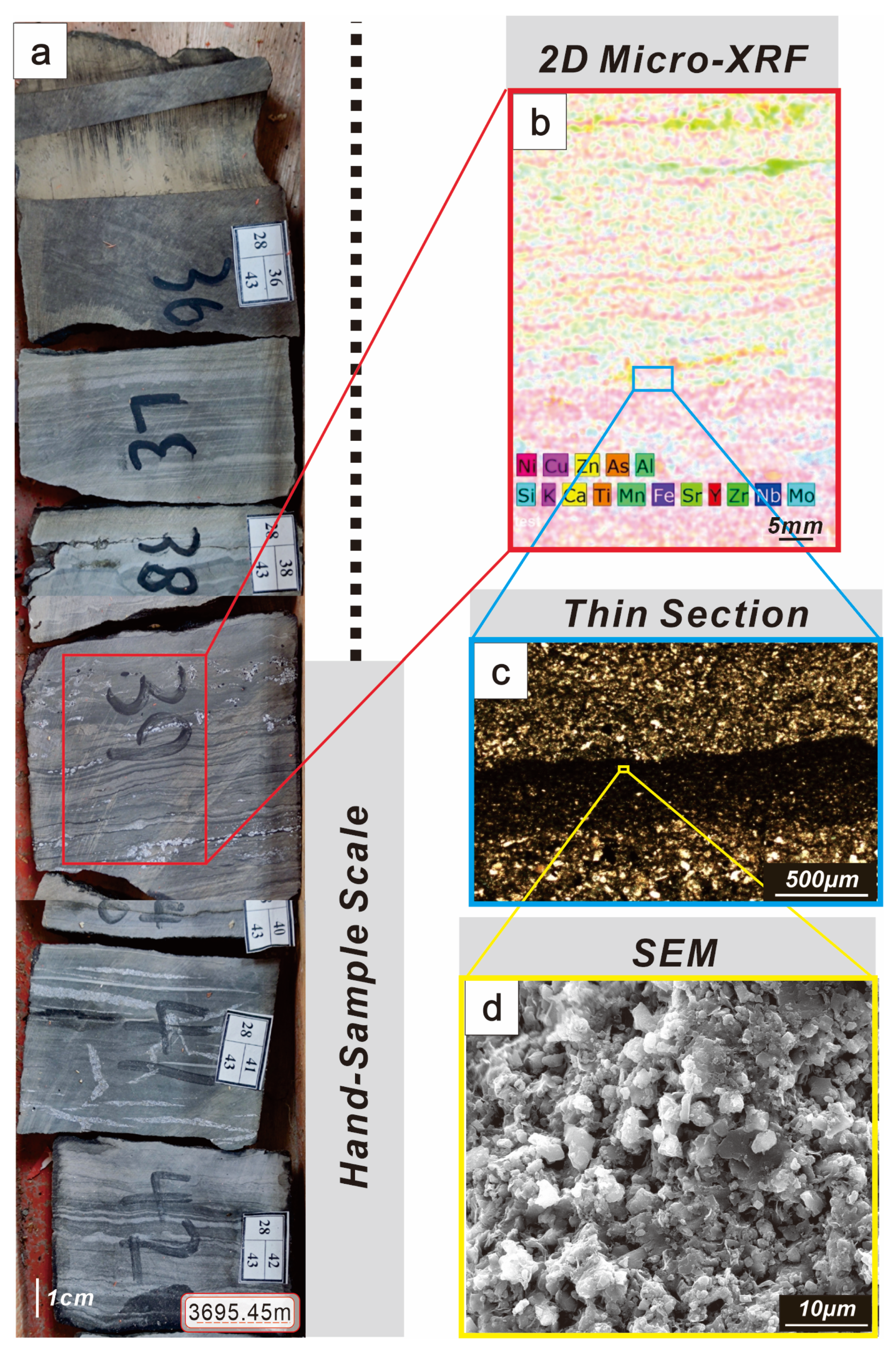
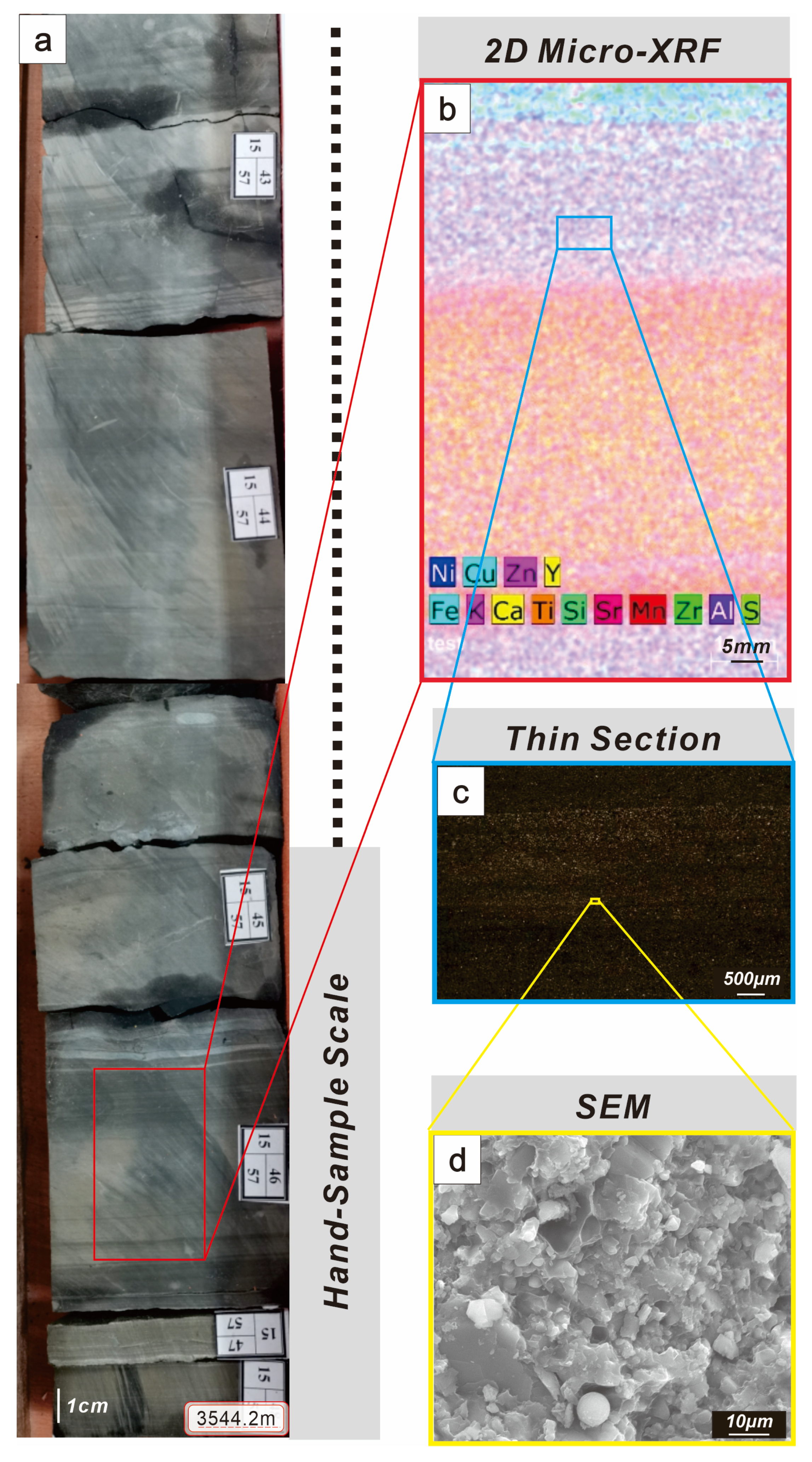
3.1. Core Samples

In the direction of provenance advancement, four wells were consecutively drilled from the southwest to the northeast in the central part of the Jimusaer Depression, resulting in a continuous well profile of Section 1 of the Lucaogou Formation (Figure 1b). The well samples were chosen based on their distance from the source, which effectively reflects changes in sedimentary subfacies. The stratigraphic information of the Permian for the four wells is provided in Table 1. Logging data from these wells (W1, W2, W3, and W4) were collected, including natural gamma-ray (GR), log lithology, nuclear magnetic porosity (35 ms), and sedimentary structures.
To facilitate a comprehensive and accurate analysis of lithofacies types, reservoir characteristics, and resource potential of the Lucaogou Formation, detailed core observations and descriptions were conducted prior to sample collection. Core sample photographs were primarily obtained from Well W2 in Section 1 of the Lucaogou Formation, located at the center of the lake at depths ranging from 3670.73 to 3716.98 m (Figure 1b). Thirty core samples were selected for high-performance microarea scanning, based on their representativeness in showcasing typical sedimentary features. The overall lithology of these samples comprises mud shale and siltstone to fine sandstone, characterized by continuous deposition and good preservation. All samples underwent routine core analysis (porosity, permeability), optical microscope examination, and electron microscope identification. The thin section and SEM samples were selected for their representative mineral contacts, millimeter-scale porosity, typical laminated features, and common mineral compositions, such as clay minerals, quartz, and carbonate.

3.2. Methods

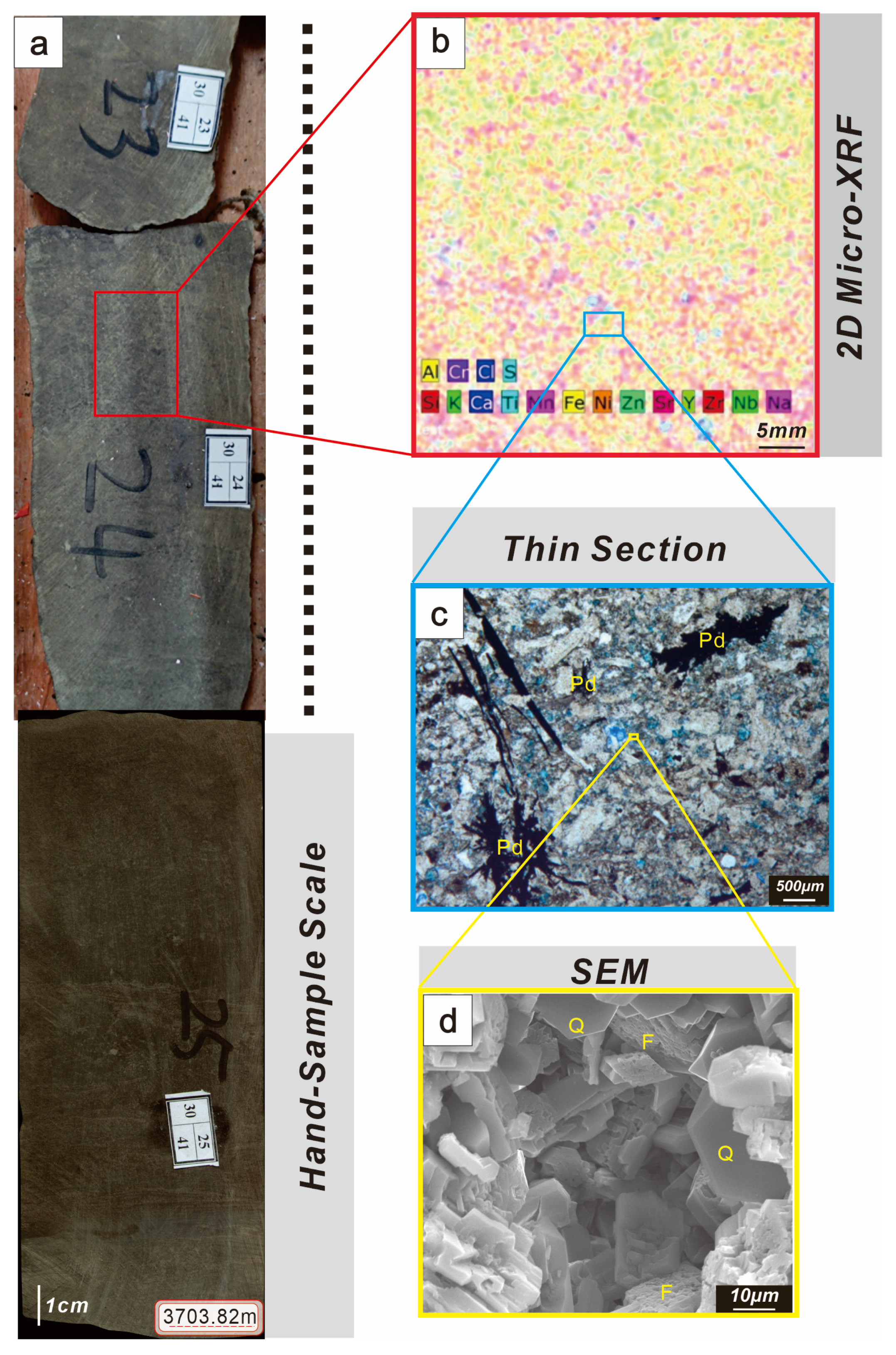
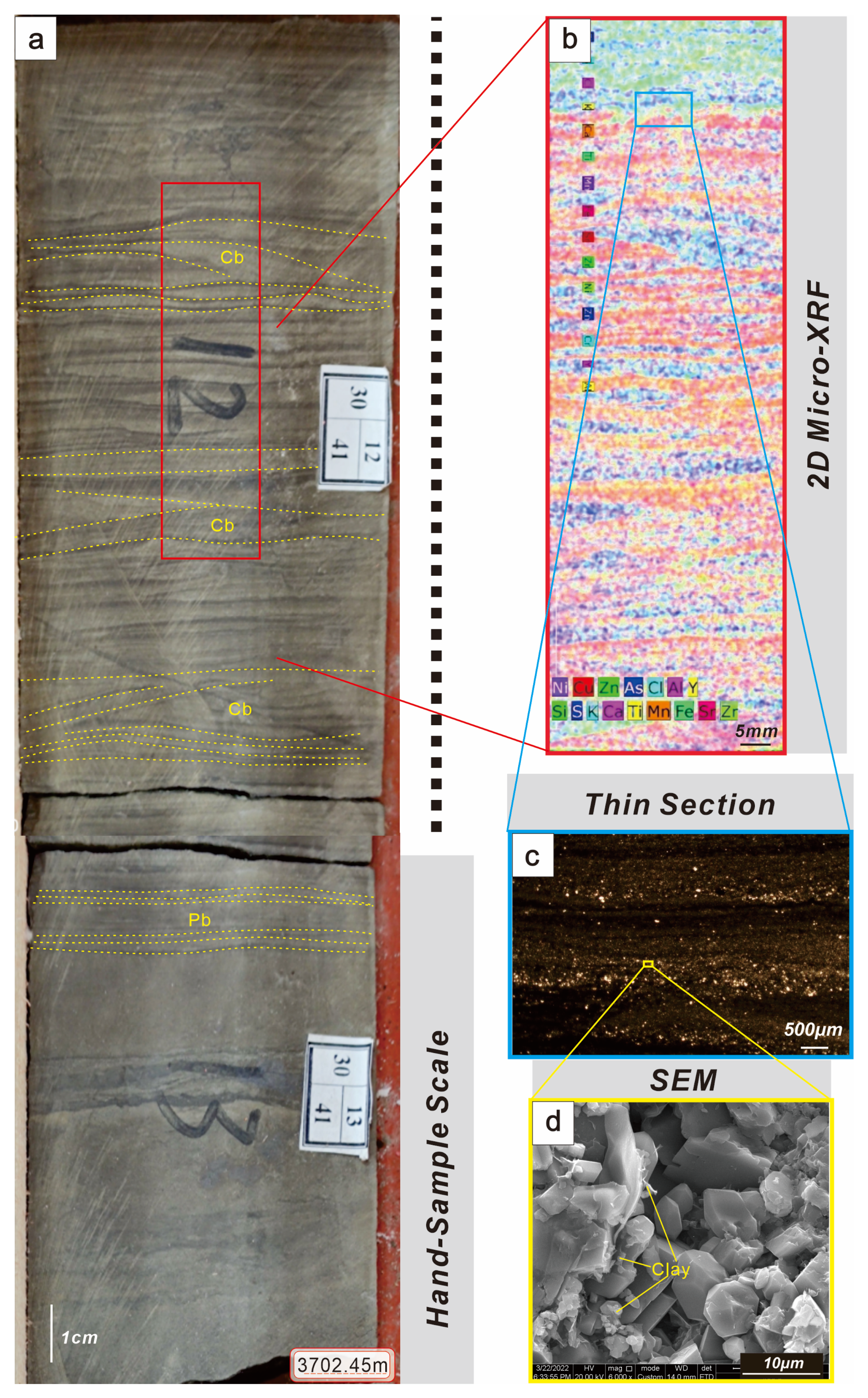
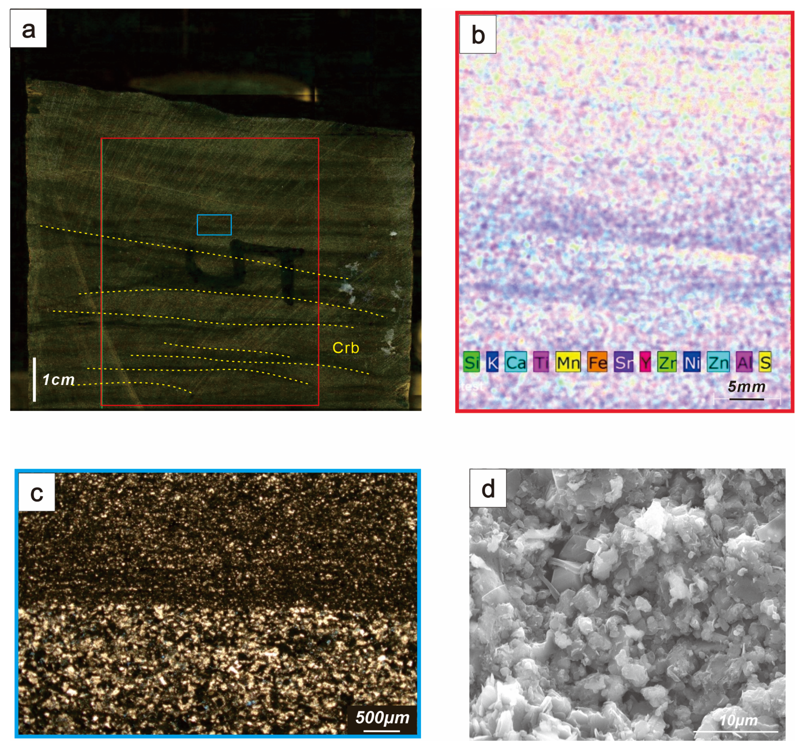
3.2.1. Core Analysis

Detailed observations and descriptions of the core photographs for Well W2 were conducted, focusing primarily on color, sedimentary structures, fracture development, and macroscopic oil-bearing phenomena, which served as the foundation for lithofacies identification. A Micro-XRF M4 Tornado (Bruker Corporation in Billerica, MA, USA) was utilized to perform high-performance 2D microarea scanning, which enabled the investigation of the spatial distribution of surface elements and the characterization of lamination in the laminated lithofacies. Mineral scanning was conducted on the Lucaogou Formation, Section 1 of Well W2, between 3679.75 m and 3709.33 m, to determine the contents of clay minerals, quartz, and carbonate minerals.

3.2.2. Logging Analysis

In the southern Jimusaer Depression, Wells W1, W2, W3, and W4 were selected sequentially from southwest to northeast to establish a continuous well profile of Section 1 of the Lucaogou Formation, corresponding to the direction of provenance progression. Stratigraphic comparisons among these four core wells were performed by integrating core sediment subfacies identification, nuclear magnetic porosity (35 ms) log interpretation, and log curve similarity analysis. This approach yielded insights into the reservoir’s lateral geometry, thickness, and physical property variations. The analysis focused primarily on the lithofacies of Well W2, with comparative assessments from the other three wells.

3.2.3. Thin Section Analysis

Cast thin sections were prepared and examined using a LEICA DM4P polarizing microscope (Leica Microsystems, Wetzlar, Germany) under both plane polarized light (PPL) and cross-polarized light (XPL), with the sections embedded in blue epoxy resin. An objective lens with a maximum magnification of 50× was employed. The observations concentrated on the contact relationships between minerals, millimeter-scale porosity, and laminated features. Mineral and pore counting within the field of view was conducted to determine the material composition, porosity development, and interparticle relationships of the samples.

3.2.4. Scanning Electron Microscope Analysis

The scanning electron microscope (SEM) was employed for the observation of pore characteristics and quantitative analysis of mineral compositions. Field emission SEM analyses were performed on 25 representative core samples using the Helios Nano Lab 650 (Thermo Fisher Scientific in Waltham, MA, USA). Observations included rock composition, micrometer-scale porosity, and interparticle filling modes.

4. Results

At the macroscopic scale, sedimentary structures were summarized based on observations of bedding and laminations in the core. At the microscopic scale, lithofacies were inferred from a comprehensive analysis of grain size, compositional assembly, sedimentary environments, and hydrodynamic and sedimentary processes. Seven lithofacies types were identified: massive bedding siltstone/fine-grained sandstone, cross-to-parallel bedding siltstone, climbing ripple laminated argillaceous siltstone, paired graded bedding argillaceous siltstone, irregular laminated argillaceous siltstone, irregular laminated silty mudstone, and horizontal laminated mudstone.

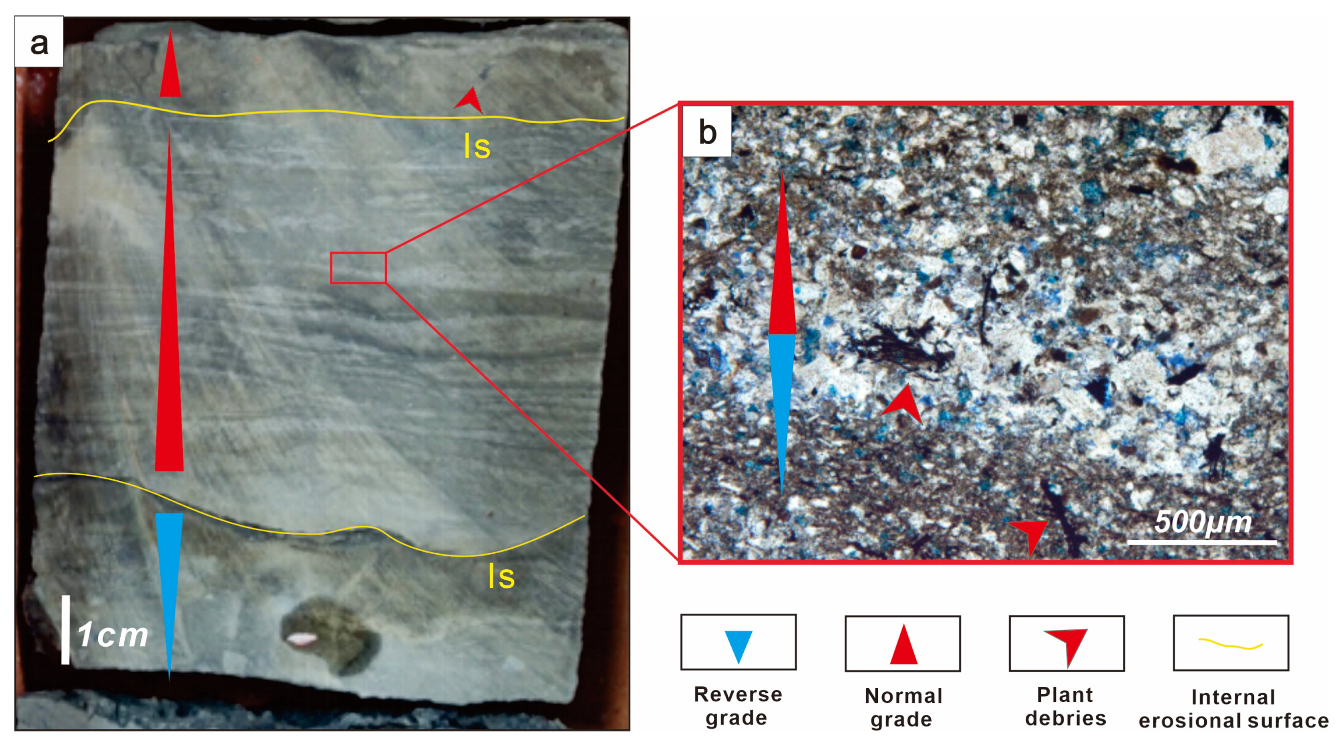
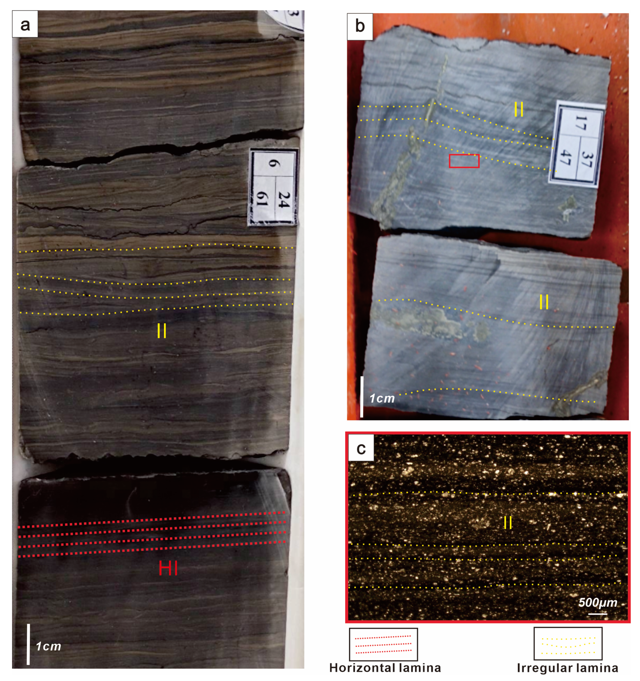
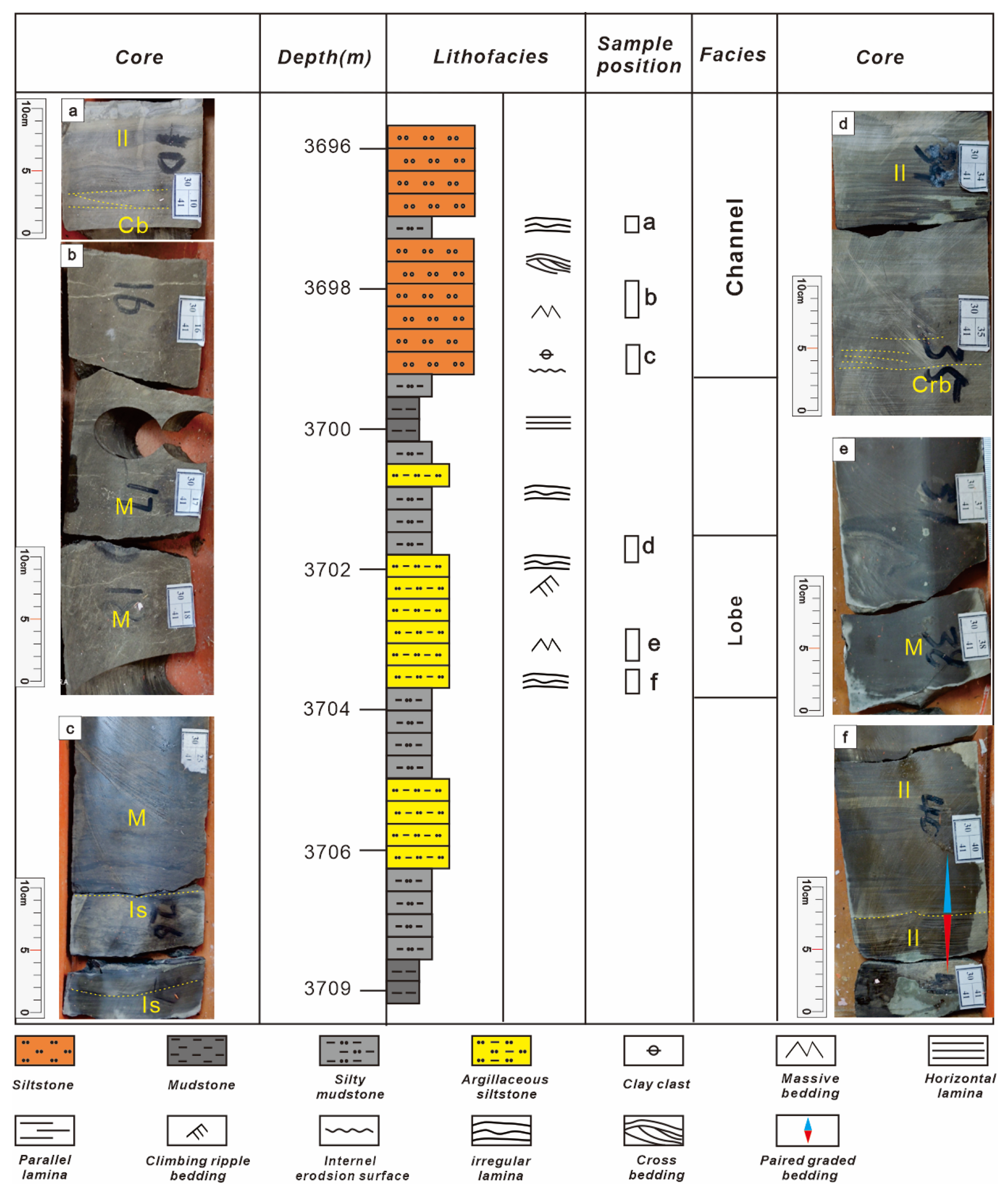
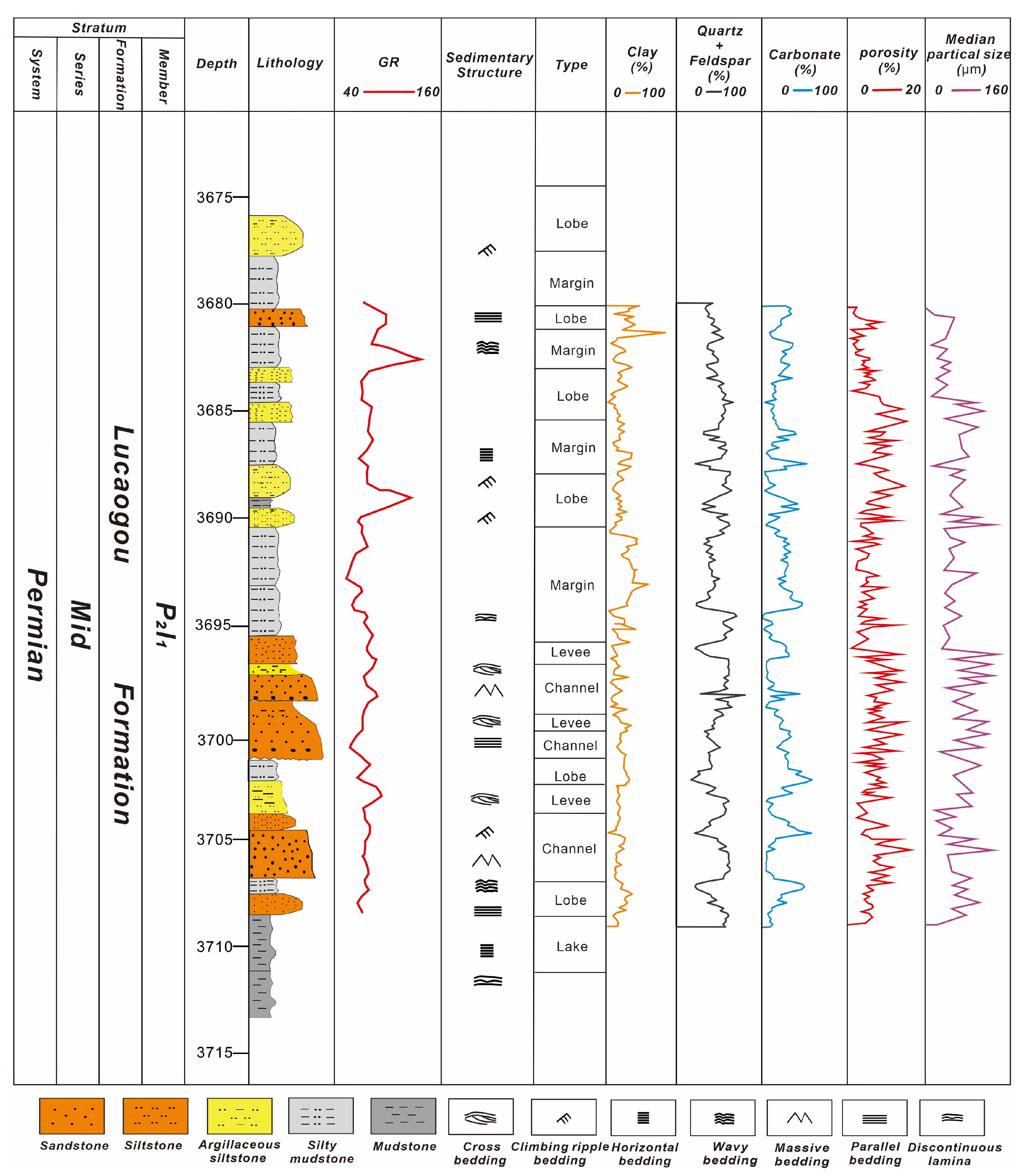
4.1. Lithofacies Observation

Massive bedding siltstone/fine-grained sandstone (LS1, Figure 2): From both macroscopic and microscopic perspectives, the massive bedding sandstone exhibits features indicative of suspended load deposition. The rock is generally gray-brown and comprises detrital particles, including quartz, feldspar, lithic fragments, and plant debris. Fossils are sparse (BI = 0) (Figure 2a). Thick layers, nearly 2 m in thickness, of massive bedding siltstone/fine-grained sandstone deposits display a normal grading pattern without distinct internal boundaries. The basal contact is sharply defined, whereas the upper portion transitions into laminated, muddy, very fine sandstone with mud veins, suggesting a deeper depositional environment. High-resolution microarea scans indicate that the elemental distribution in the upper core is relatively uniform, with localized zones of enrichment. The core also exhibits enrichment in Ca, Fe, Mn, and S (Figure 2b). Thin-section analysis reveals abundant plant fragments, with a silt content of 70% predominantly composed of feldspar. The feldspar, mainly plagioclase, occurs as long or short columns ranging in size from 50 to 200 μm, intermingled with clay containing mud flakes. A well-developed pore network is observed, comprising both intergranular and intragranular dissolution pores, with occasional moldic pores (Figure 2c). Rock fragments are moderately sorted, with interparticle spaces frequently filled with mud, resulting in well-developed porosity. Silica fills the interstitial spaces, and partial dissolution of feldspar grains promotes good pore connectivity and uniform distribution (Figure 2d).
Cross/parallel laminated argillaceous siltstone (LS2, Figure 3): The facies exhibit centimeter-scale cross and parallel laminated structures in the vertical direction. The upper portion gradually transitions to irregular lamination, displaying features reminiscent of biogenic trace fossils (Figure 3a). High-resolution microarea scans correlate strongly with the core photographs, revealing marked vertical variations in elemental composition and notable enrichment of Fe, Ca, K, Mn, and Ti (Figure 3b). In thin section, the rock exhibits a laminated structure with oriented layering, producing striped patterns as a result of the interbedding of silt and clay. The silt content is 55%, primarily consisting of feldspar and quartz, with fine crystals of varying sizes (Figure 3c). Scanning electron microscopy reveals well-sorted rock fragments interspersed with mud, resulting in a dense rock structure with few pores. The interparticle spaces are filled with platy clay minerals, with localized development of micropores (Figure 3d).
Climbing ripple laminated argillaceous siltstone (LS3, Figure 4): The core profile predominantly exhibits climbing ripple lamination, characterized by unidirectional ripples with an upward-climbing trend (Figure 4a). The core displays a laminated structure, with white bands indicating the presence of Ca, Fe, Mn, and Si, while black bands contain K, Si, and Y (Figure 4b). The thin section reveals laminated development, where mud and organic matter are intermingled, and bright, quartz-rich laminations measure approximately 2–5 mm in thickness (Figure 4c). SEM analysis shows that rock fragment particles are poorly sorted, with interparticle spaces filled with mud, silica, and other materials. The dominant structure consists of platy mud, with few interparticle micropores and only a limited number of dissolution pores observed (Figure 4d).
Paired graded bedding argillaceous siltstone (LS4, Figure 5): The core exhibits various irregular lamination structures. The base is characterized by erosion surfaces, while the section as a whole displays normal grading, with erosion surfaces located at the base of the graded layers within the same stratum (Figure 5a). In the thin section, the mud and very fine sand locally become enriched, forming striped interlayers, with abundant plant debris and widespread dissolution pores observable (Figure 5b).
Irregular laminated silty mudstone (LS5, Figure 6): In the core, irregular laminations consist predominantly of dark mudstone and light-colored, very fine sandstone, interbedded in a nonuniform pattern. Variable dolomite and calcite infillings are also observed (Figure 6a). High-resolution microarea scanning indicates potassium enrichment in the dark laminations, suggesting a laminated distribution of clay minerals. The laminations exhibit poor continuity, marked lateral variation, and irregular surfaces, with thicknesses ranging from 1 mm to 3 mm. Normal grading is observed within 1 mm thick layers, with abrupt transitions evident above (Figure 6b). Thin-section analysis reveals a quartz content of 50%, primarily associated with feldspar, with grain sizes ranging from 30 to 100 μm. The clay content is 40%, displaying a dark coloration and local enrichment in striped patterns. Dolomite constitutes 10%, dispersed at the mud-crystal scale. In some intervals, both mud and mud-crystal dolomite are enriched, forming striped patterns, while very fine sandstone develops as interlayers (Figure 6c). Under electron microscopy, rock fragment particles are moderately sorted, with interparticle spaces frequently filled by mud-crystal dolomite, silica, and other minerals. Porosity is well developed, with a few dissolution pores observed.
Irregular laminated mudstone (Lm1, Figure 7): The lithology is complex, comprising dark gray mudstone and silty mudstone. The silty mudstone is intercalated within the dark gray mudstone as irregular, millimeter-scale laminations, generally accounting for less than 20% of the cumulative thickness. These irregular laminations are characterized by discontinuous, curved, and lens-shaped features (Figure 7a,b). Thin-section analysis demonstrates a laminated structure, with mud arranged in an oriented pattern. The quartz content is 20%, with grain sizes ranging from 25 to 73 μm. The mud content is 61%, exhibiting a dark appearance and irregular lamination, accompanied by poorly developed porosity (Figure 7c).
Horizontal laminated mudstone (LM2, Figure 8): The core and thin sections display alternating dark and light laminae, formed by the oriented intercalation of silty and clay materials. The dark layers are enriched in clay minerals and organic matter, while the light layers consist primarily of terrigenous detrital minerals, such as quartz and feldspar, with no evidence of bioturbation (Figure 8a). In the core, the white bands are enriched in Ca and Sr, whereas the black bands are rich in Fe, Cu, K, Mn, Ni, Zr, Ti, Y, and Zn. In the thin section, the clay content is 80%, appearing black and mixed with organic matter, making it difficult to distinguish; locally, it is enriched in long stripes or bands (Figure 8b). The silt content is 12%, predominantly feldspar, with quartz grains stained brown by organic matter. The pyrite content is 2%, occurring in aggregates (Figure 8c). Under the electron microscope, the rock structure is dense, with very fine, undeveloped pores, and the organic matter is often associated with clay minerals (Figure 8d).

4.2. Interpretation

Core observations indicate that extensively developed sedimentary structures reflecting flow processes serve as a key distinguishing feature of hyperpycnal flow deposits compared to other gravity flow deposits [23]. The lithofacies summary is consistent with the depositional characteristics of hyperpycnal flows, as evidenced by: (1) The paired graded bedding combinations that can be observed between layers of varying grain sizes, where internal erosional surfaces caused by flood peaks are present; (2) thick massive bedding composed of siltstone/fine-grained sandstone in which sediment grain size and depositional structures repeatedly vary within compound layers; (3) a vertically rhythmic sequence in the core containing visible plant debris; and (4) the presence of erosional surfaces within the layer [25,26,27,28,29,30].
The massive bedding sandstone facies, characterized by high individual layer thickness, both normal and reverse grading, and minimal bioturbation, are indicative of rapid sediment transport. Rapid sedimentation produces blocky sandstones with loosely packed infills, thereby exhibiting high original porosity [31]. Normal grading is indicative of suspension settling; in the absence of bottom flow transport, the homogeneous settling of particles during deposition yields a uniform structure due to the hydraulic equivalence of the particles.
Small-scale cross and parallel laminated argillaceous siltstone facies represent rapid sediment deposition by sediment gravity flows in distal submarine fan environments, reflecting the depositional characteristics of traction currents. The occurrence of cross-lamination suggests transport and reworking by bottom currents. The parallel laminations were often present above the massive structureless units, indicating high-energy conditions [32].
Climbing ripple lamination, a distinctive feature in deep-sea sediments, is useful for differentiating hyperpycnal flow deposits from other deep-water gravity flow deposits [33]. It also signals the onset of fluid lateral migration rates that exceed deposition rates. The vertical transition from parallel lamination to climbing ripple lamination implies a combined formation mechanism involving traction and gravity flow sedimentation under turbulent conditions [34]. High-performance elemental microarea scanning, which revealed enrichment in Ca, Fe, and Mn, suggests periodic input of metal ions during deposition, consistent with rapid sedimentation in a high-energy environment.
Graded bedding in the siltstone facies reflects a typical depositional sequence of hyperpycnal flows during a flood event, transitioning from increasing to decreasing energy [35]. After the flood peak, as energy diminishes, sediments transported by hyperpycnal flows are deposited from coarse to fine, exhibiting normal grading. These depositional structures are the inverse of those formed during the phase of increasing current energy; if the flood peak is sufficiently high and sustained, reverse-graded units formed during the energy increase phase may be entirely eroded during the peak, leaving only normally graded units after the flood as hyperpycnal flow energy wanes and sediments are unloaded. Plant debris within the coarser sand layers in the grading (Figure 5) indicates typical channel/lobe edge areas in a saline lake basin, where featherbed rhythmic layers form due to density inversion, rendering such depositional structures common within lobe bodies.
Irregular laminated silty mudstone is commonly superimposed on horizontally laminated silty mudstone in the vertical sequence (Figure 7). This results from fluctuations in hyperpycnal flow energy, causing minor variations in flow velocity and relative changes between sedimentation rate and flow rate. Both core and thin-section observations reveal alternating light and dark laminations, likely due to disturbances in fluid settling within a quiescent water environment at the end of sediment transport. The presence of thin sand layers and frequent interlayering with mud veins suggests the characteristics of vertically stacked, low-energy, multiple flood hyperpycnal flow events. Vein-like and spotted calcite fillings indicate that high salinity in high-density water bodies promoted the precipitation of carbonate minerals [35].
Horizontal laminated mudstone reflects overall weak hydrodynamic sedimentation, with no fluvial structures observed in the sandstone, suggesting formation by the settling of suspended particles under normal gravitational forces. This indicates the slow settling of clay particles under still water conditions. The sedimentary environment of irregular laminated mudstone is relatively deeper—similar to that of horizontally laminated mudstone—but is influenced by specific hydrodynamic conditions, implying some degree of fluid disturbance.

5. Discussion

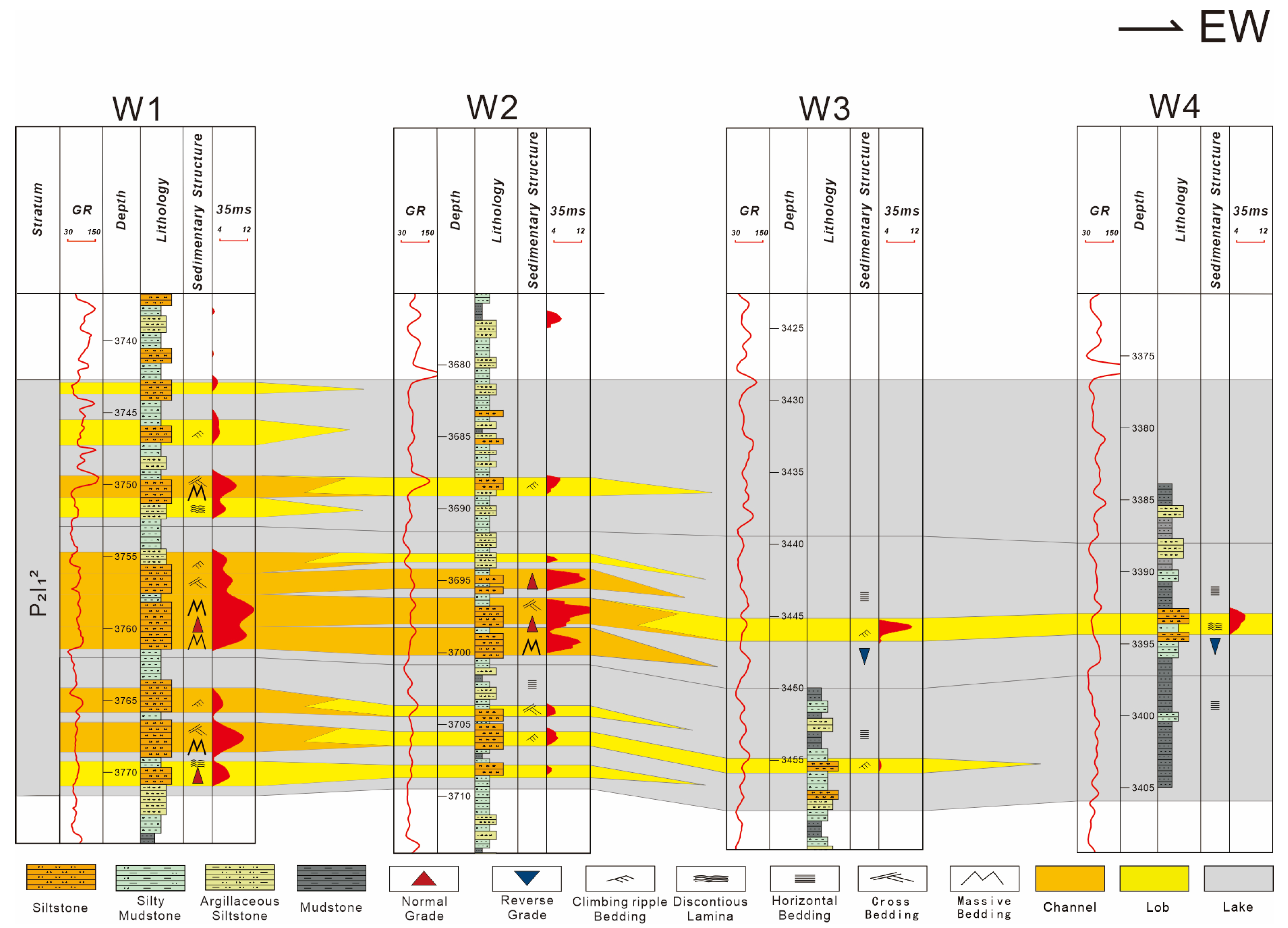
5.1. Sedimentary System

There is significant debate among scholars regarding the sedimentary facies of the Luchagou Formation in the Jimusaer Depression, particularly concerning the types of sedimentary facies and their microfacies distribution. Some scholars argue that the formation primarily consists of lacustrine and deltaic facies [36], while others propose models based on beach-bar deposition and sandy lake deep-water fan systems [37]. However, the existing sedimentary models do not adequately address the vertical stratification, spatial variability, and hydrodynamic mechanisms present within the lithofacies associations.

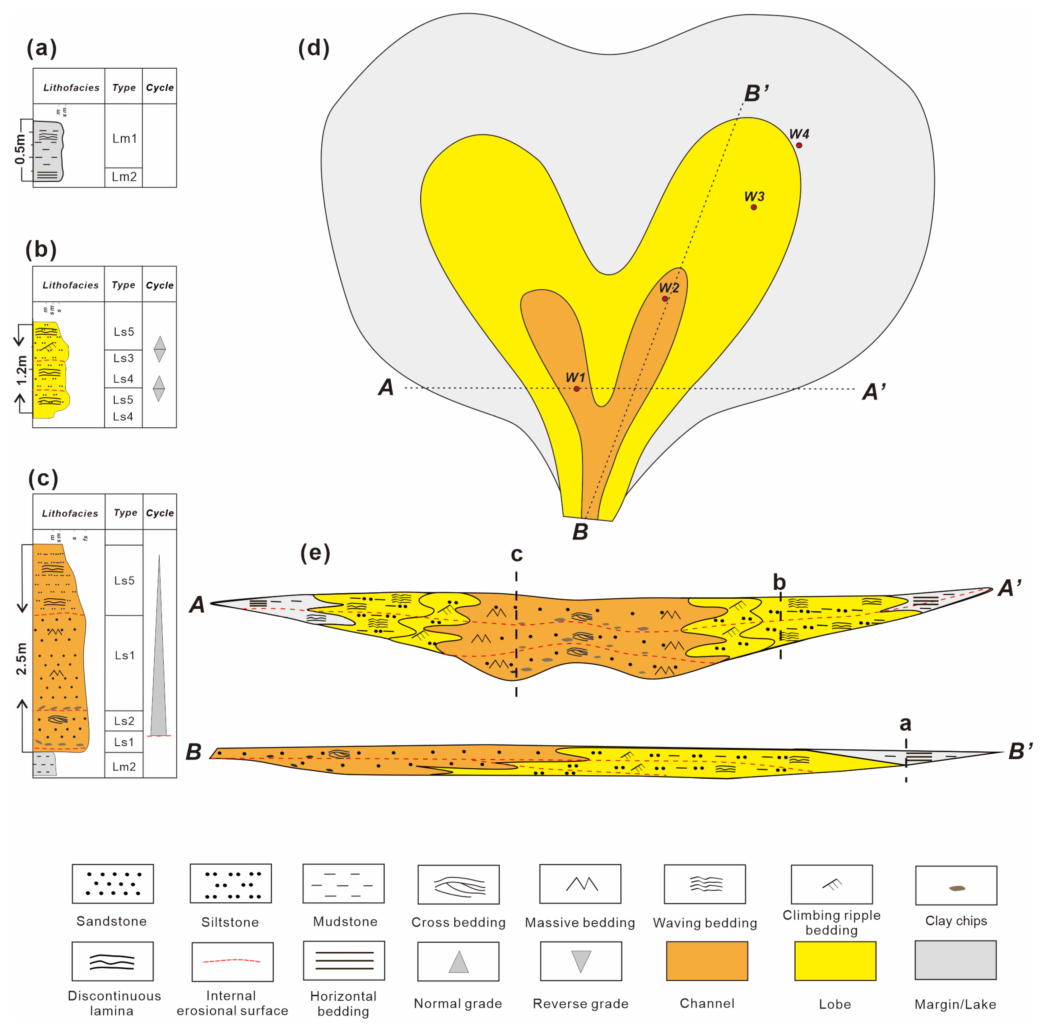
5.1.1. Lithofacies Assemblage Features

Based on core well data, the genetic relationships of rock strata were analyzed as a unit by examining vertical sedimentary structure combinations and lateral variations to interpret the sedimentary environment (subfacies analysis). Two subfacies, namely channel and lobe, were identified within the cores. Under hyperpycnal flow conditions, the associated loading mechanisms for different facies include bedload transport, suspended load transport, and flotation transport, in accordance with the classification standards [26].
In the channel subfacies, very fine to fine sandstone predominated, exhibiting massive bedding and cross-bedding. For example, the interval from 3697.2 to 3699.2 m in Well W2 of the Lucaogou Formation displays two sets of internal erosional surfaces at the base of the assemblage (Figure 9c). The main body is characterized by a massive bedding of very fine sandstone (Figure 9e) with localized cross-bedding and is capped by a thin layer of irregular laminated silty mudstone (Figure 9f). This combination of sedimentary structures reflects a transition in flood hyperpycnal flow energy from weak to strong and back to weak, with a corresponding shift from suspended load to bedload and then back to suspended load, which is interpreted as sedimentation in a hyperpycnal flow channel.
The lobe facies were subdivided into lobe and lobe-margin subfacies. The primary lithologies comprise very fine sandstone and silty mudstone, characterized by graded bedding, climbing ripple lamination, and irregular lamination. The subfacies sequence is most completely developed in Well W2 of the Lucaogou Formation between 3702.0 and 3703.4 m. The base of the assemblage features irregular lamination, followed by graded bedding (Figure 9f), a middle layer of massive bedding (10–20 cm thick) (Figure 9e), and is capped by climbing ripple lamination combined with irregular lamination (Figure 9d). This sedimentary structure, formed during fluctuations in flood hyperpycnal flow energy, predominantly comprises suspended load deposits and is interpreted as hyperpycnal flow lobe deposits. These deposits correspond to relatively weak hydrodynamic conditions, finer lithologies, and relatively thin individual layer thicknesses (1.4 m).
The margin/lake subfacies comprise an alternating sequence of irregularly laminated silty mudstone and horizontally laminated mudstone (Figure 7a), with distinctly thin individual layers that are readily identifiable in core observations. The horizontally laminated mudstone reflects low-energy depositional conditions characterized by suspended particles settling under normal gravity, whereas the irregularly laminated type, though also deposited in similarly deep water, indicates slightly stronger hydrodynamic conditions with minor fluid disturbance. Due to the absence of significant differences in well-log responses and genetic mechanisms between these two lithofacies, they are grouped as a single subfacies unit.

5.1.2. Sedimentary Model

Statistical analysis of subfacies, reservoir thickness, and nuclear magnetic porosity characteristics from four core wells indicates that the channel subfacies possess a greater single-layer thickness with a thick, wedge-shaped lateral geometry (ranging from 1.3 to 3.8 m, with a mean of 2.2 m). Nuclear magnetic porosity in these subfacies varies from 6.0% to 12.3%, with a mean value of 9.0% (Figure 10). In contrast, the lobe subfacies exhibit a thinner single-layer thickness (ranging from 0.5 to 1.4 m, with a mean of 0.9 m) and display shapes that vary from slab-like to strip-like. The nuclear magnetic porosity in the lobe subfacies ranges from 3.5% to 7.8%, with an average of 5.2%. Moreover, the thickness of individual sand bodies gradually decreases from the channel subfacies to the lobe subfacies (Figure 10). Integration of the subfacies assemblage characteristics and the planar distribution features observed in the Jimusaer Depression core wells led to the establishment of a sedimentary model for the Jimusaer Depression.
Due to the considerable distance of the Lucaogou Formation from the source area, the basin was primarily influenced by persistent turbulence transporting sandy sediments. During this period, hydrodynamic forces reached their peak, with floods carrying high-density sandy fluids capable of eroding the riverbed. Thick sand bodies were deposited, often developing erosional surfaces, massive bedding, and cross-bedding features indicative of rapid accumulation typical of depositional structures (Figure 11c), reflecting a bedload transport origin for hyperpycnal flow channels. The sand bodies exhibit a lens-shaped profile and appear as strip-tongue shapes in plan view (Figure 11d,e).
At both ends of the main channel, natural levees were identified, typically overlain by thin layers above channel microfacies and formed by the depositional action of flowing water along levee margins. Reduced sedimentation rates and flow velocity, combined with a lateral thrust from ongoing flood supply, led to the development of climbing ripple lamination, indicating the predominance of suspension transport. These features typically surround the channels, covering relatively small planar areas.
As the channel progressed, the fluid energy diminished further, reducing its capacity to erode the bedload and resulting in the settling of fine sediments. The relatively flat and open terrain facilitated the dispersion of the fluid, further lowering its energy and causing the sediments to disperse and form lobe-shaped gravity flow sand body deposits. The frequent superposition of graded bedding indicates that the fluid no longer possessed erosive capability, with the sediments fully recording variations in flood energy (Figure 11b). These deposits are distributed at channel termini and interchannel areas, exhibiting a fan-shaped or elongated tongue-like distribution over a wide area (Figure 11d).
In the later stages of fluid movement, marginal and lacustrine facies were formed. Irregularly laminated silty mudstone and horizontally laminated mudstone were deposited at the top and bottom of the depositional sequence (Figure 11a), reflecting the hydrodynamic transition from hyperpycnal flow disturbances dominated by plume loads to calm lacustrine waters.

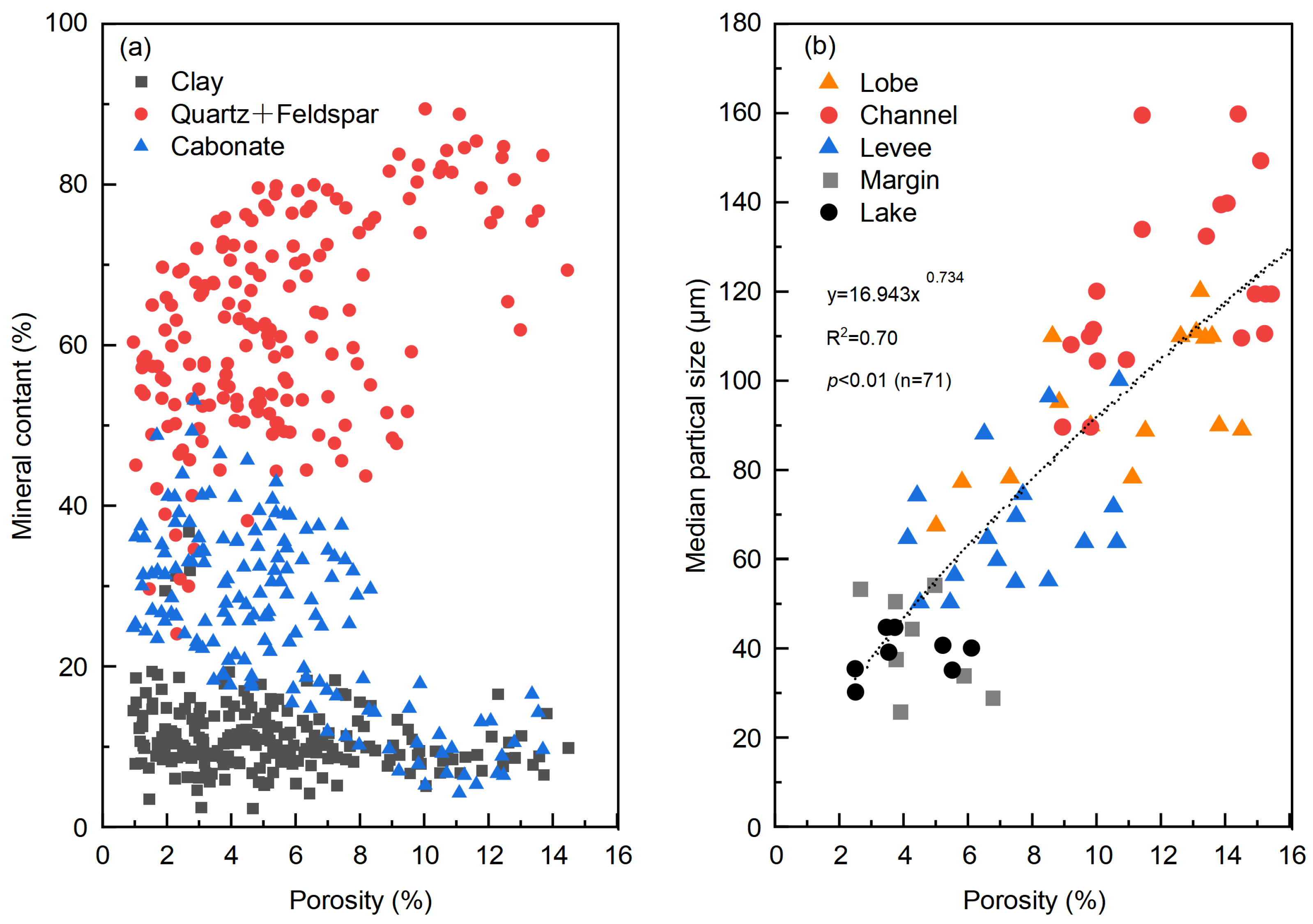
5.2. Reservoir Control Factors

The Lucaogou Formation, a source-reservoir integrated shale oil system, provides favorable conditions for the formation of high-quality reservoirs due to its oil potential. The distribution of organic matter types and the variations in maturity within the Lucaogou Formation are closely linked to the region’s oil and gas generation capabilities [38]. The dominant kerogen type in the Lucaogou Formation is Type I, followed by Type II1, both of which exhibit high organic matter content [39]. The average TOC content reaches 4.40%, and the vitrinite reflectance ranges from 0.62% to 1.27%, with an average value of 0.8%, indicating that the formation has entered the mature stage and holds significant oil and gas generation potential [40].
For unconventional reservoirs, the term “sweet spot” refers to regions within the unconventional strata that have better reservoir quality, are more easily fractured, and offer higher economic potential [41]. The Permian “sweet spot” reservoirs in the Junggar Basin are defined as shale oil intervals with porosities exceeding 6% [13,21]. Porosity is a critical parameter for characterizing reservoirs in fine-grained sedimentary rocks [13]. It is generally influenced by factors such as mineral composition and grain size. Therefore, investigating the effects of these factors on porosity can provide valuable criteria for assessing the quality of the Lucaogou Formation reservoirs.

5.2.1. Factors Affecting Porosity

An integrated stratigraphic column was constructed using lithological, sedimentary facies, mineralogical composition, and porosity data from the Lucaogou Formation (Figure 12). Based on the composite stratigraphic column, a cross-referencing analysis was conducted to examine the relationships among clay mineral content, quartz content, carbonate content, and porosity in sandstone samples from the Lucaogou Formation (Figure 13a). Statistical analysis shows that porosity increases as carbonate content decreases and quartz content increases. The abundance of brittle minerals, such as quartz and feldspar, is crucial for determining reservoir brittleness. Higher concentrations of brittle minerals, including quartz and feldspar, facilitate the formation of natural fractures [21,42,43]. During fracturing and stimulation, these minerals also promote the development of complex induced fractures, enhancing the extension and connectivity of fracture networks, which in turn increases porosity [44]. Additionally, higher quartz content improves the rock’s resistance to compaction during diagenesis, helping to preserve pore space and maintain porosity [24]. In contrast, carbonate cementation, which primarily occurs during the early diagenetic stage (Stage I cementation), fills primary pores during rapid burial and leads to a reduction in porosity [45]. No significant correlation was found between clay mineral content and porosity, suggesting that cementation by clay minerals does not significantly affect reservoir porosity. This may be because clay minerals are less widespread than carbonate cements and are present in much lower quantities [46].
Additionally, we performed a cross-referencing analysis of porosity and median grain size (d50). A strong positive correlation was observed between rock grain size and reservoir porosity (Figure 13b), with the largest grain sizes occurring in channel environments. This is attributed to the coarser materials formed in high-energy environments, which exhibit larger grain sizes and higher resistance to overburden pressure [12]. As a result, the development of better pore structures is enhanced, thus improving reservoir properties.
After identifying the impact of quartz and carbonate content on porosity in the Lucaogou Formation, we further analyzed the correlation between porosity and these two minerals across different microfacies sample points to better understand the favorable depositional subfacies for optimal reservoir formation. The results show a progressive decrease in quartz content and an increase in carbonate content from the channel to the lobe, natural levee, and margin-deep lake mud microfacies (Figure 14). In the channel, quartz content exhibits a significant positive correlation with porosity (Figure 14a), as the higher quartz content in coarser-grained sandstones leads to increased dissolution and intergranular porosity, thereby enhancing reservoir quality. Conversely, carbonate content in the channel shows a negative correlation with porosity (Figure 14b). It was suggested that carbonate cementation plays a key role in reducing porosity, thereby decreasing reservoir quality [7]. In contrast, porosity in the margins and lake is generally below 6% and does not show a significant correlation with mineral content (Figure 14).

5.2.2. Reservoir Controlling Factors Model

Channel-lobe, natural levee-margin, and lake depositional microfacies exhibit a close genetic relationship both vertically and laterally. Vertically, they form channel-natural levee-margin/lake deposits (Figure 15a), characterized by climbing ripple lamination, graded bedding, irregular lamination, and horizontal lamination. Laterally, in the direction parallel to the channel, they form channel-lobe-margin/lake deposits (Figure 15b), reflecting a shift in depositional mechanisms from bedload to suspended load to plume load. This sequence is interpreted as a sedimentary process where flood density current energy increases and then decreases. Consequently, sand bodies gradually thin, porosity decreases, quartz content declines, carbonate mineral content increases, and reservoir properties deteriorate.
The changes in reservoir properties within the Lucaogou Formation are closely linked to variations in depositional facies. Microfacies changes indicate fluctuations in flood dynamics, which influence sediment particle settling and mineral content, thereby controlling variations in reservoir properties.

6. Conclusions

The major findings regarding the multiscale characteristics and controlling factors of Permian shale oil reservoirs in the Lucaogou Formation are summarized as follows:
  • Multiscale characterization: Core examination, thin section analysis, grain-size measurement, high-performance microdrive scanning, and scanning electron microscopy allowed reservoir appraisal at centimeter, millimeter, and micrometer scales. Five principal sandstone lithofacies and two mudstone lithofacies were distinguished.
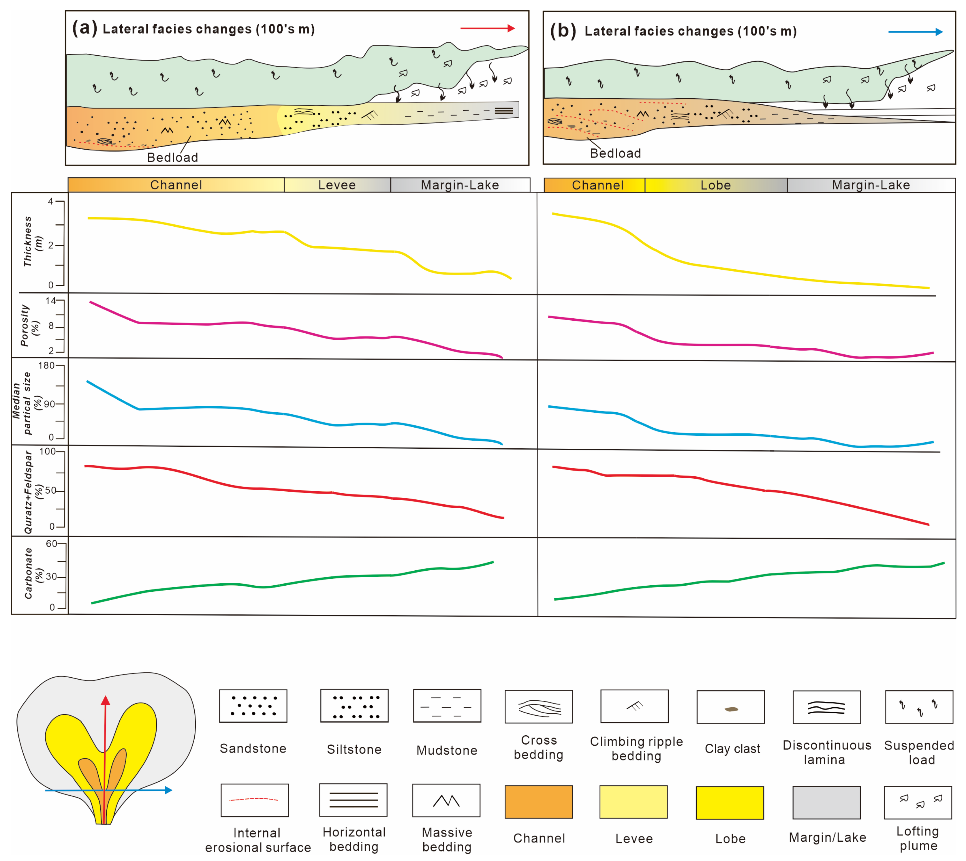
  • Lake hyperpycnal flow deposits: Extensive lake hyperpycnal flows in the Lucaogou Formation are marked by paired graded bedding sequences with internal erosion surfaces, massive bedding, and terrestrial plant fragments.
  • Subfacies architecture: Channel subfacies (LS1 and LS2) reflect strong hydrodynamic conditions, considerable thickness, high porosity. In plain view, these sand bodies exhibit elongate or tongue-like geometries, constituting the primary sweet-spot reservoirs. In contrast, Lobe subfacies (LS3–LS5) reflect moderately strong hydrodynamic conditions, thinner single-layer thickness, and lower porosity. Plan-view geometries are fan-shaped, representing secondary sweet-spot reservoirs.
  • Reservoir-source rock coupling: High-density hyperpycnal flows transported abundant clastic and terrigenous organic matter into the lacustrine basin, depositing coarse-grained sediments that formed channel and lobe reservoirs while supplying nutrients. Suspended nutrient plumes settled with fine clay particles in the deep lake, generating high-quality source rocks. Repeated fluctuations in fluvial energy induced vertical alternations and extensive contacts between hyperpycnal flow deposits (channels and lobes) and deep-lake mudstones, yielding favorable reservoir-source rock assemblages.

Author Contributions

Conceptualization, Y.L.; methodology, X.C. and L.Z.; software, Y.L.; validation, Y.L., X.C. and L.Z.; formal analysis, Y.L. and X.T.; investigation, Y.L.; resources, X.C. and X.T.; data curation, Y.L. and X.T.; writing—original draft preparation, Y.L.; writing—review and editing, Y.D.; visualization, Y.D.; supervision, P.L.; project administration, X.C.; funding acquisition, X.C. All authors have read and agreed to the published version of the manuscript.

Funding

This work is funded by the National Natural Science Foundation of China (4207119) and National Science and Technology Major Project of China National Petroleum Corporation Limited (2019E-26, 2019E-26-07, 2019E-26-08).

Data Availability Statement

All data and materials are available on request from the corresponding author. The data are not publicly available due to ongoing researches using a part of the data.

Conflicts of Interest

The authors declare no conflicts of interest.

References

  1. Zou, C.; Zhu, R.; Wu, S.; Yang, Z.; Tao, S.; Yuan, X.; Hou, L.; Yang, H.; Xu, C.; Li, D.; et al. Types, Characteristics, Genesis and Prospects of Conventional and Unconventional Hydrocarbon Accumulations: Taking Tight Oil and Tight Gas in China as an Instance. Acta Pet. Sin. 2012, 33, 173–187. [Google Scholar]
  2. Zou, C.; Yang, Z.; Zhang, G.; Zhu, R.; Tao, S.; Yuan, X.; Hou, L.H.; Dong, D.; Guo, Q.; Song, Y.; et al. Theory, technology and practice of unconventional petroleum geology. Earth Sci. -J. China Univ. Geosci. 2023, 48, 2376–2397. [Google Scholar] [CrossRef]
  3. Du, J.; Hu, S.; Pang, Z.; Lin, S.; Hou, L.; Zhu, R. The types, potentials and prospects of continental shale oil in China. China Pet. Explor. 2019, 24, 560–568. [Google Scholar]
  4. Zhao, W.; Hu, S.; Hou, L.; Yang, T.; Li, X.; Guo, B.; Yang, Z. Types and resource potential of continental shale oil in China and its boundary with tight oil. Pet. Explor. Dev. 2020, 1, 1–10. [Google Scholar] [CrossRef]
  5. Zhao, W.; Zhu, R.; Liu, W.; Bian, C.; Wang, K. Enrichment conditions and distribution characteristics of lacustrine medium-to-high maturityshale oil in China. Earth Sci. Front. 2023, 30, 116–127+242–259. [Google Scholar]
  6. Zhang, L.; Lu, S.; Xiao, D. Controlling factors of shale reservoir heterogeneity of the Longmaxi Formation in southeast Chongqing Area. Geol. Rev. 2023, 69, 246–248. [Google Scholar]
  7. Hu, S.; Bai, B.; Tao, S.; Bian, C.; Zhang, T.; Chen, Y.; Liang, X.; Wang, L.; Zhu, R.; Jia, J.; et al. Heterogeneous geological conditions and differential enrichment of medium and high maturity continental shale oil in China. Pet. Explor. Dev. 2022, 49, 224–237. [Google Scholar] [CrossRef]
  8. Loucks, R.G.; Reed, R.M.; Ruppel, S.C.; Hammes, U. Spectrum of pore types and networks in mudrocks and a descriptive classification for matrix-related mudrock pores. AAPG Bull. 2012, 96, 1071–1098. [Google Scholar] [CrossRef]
  9. Liu, D.; Li, Z.; Jiang, Z.; Zhang, C.; Zhang, Z.; Wang, J.; Yang, D.; Song, Y.; Luo, Q. Impact of laminae on pore structures of lacustrine shales in the southern Songliao Basin, NE China. J. Asian Earth Sci. 2019, 182, 103935. [Google Scholar] [CrossRef]
  10. Xiong, J.; Liang, M.; Cao, Z.; Wang, Z.; Zheng, J.; Wang, Z. The geochemical and mineralogical characteristics of shales in Chaiwobu depression, southern margin of Junggar Basin. J. Geomech. 2017, 23, 585–593. [Google Scholar]
  11. Denne, R.A.; Hinote, R.E.; Breyer, J.A.; Kosanke, T.H.; Lees, J.A.; Engelhardt-Moore, N.; Spaw, J.M.; Tur, N. The Cenomanian–Turonian Eagle Ford Group of South Texas: Insights on timing and paleoceanographic conditions from geochemistry and micropaleontologic analyses. Palaeogeogr. Palaeoclimatol. Palaeoecol. 2014, 413, 2–28. [Google Scholar] [CrossRef]
  12. Zhang, S.; Cao, Y.; Liu, K.; Jahren, J.; Xi, K.; Zhu, R.; Yang, T.; Cao, X.; Wang, W. Characterization of lacustrine mixed fine-grained sedimentary rocks using coupled chemostratigraphic-petrographic analysis: A case study from a tight oil reservoir in the Jimusar Sag, Junggar Basin. Mar. Pet. Geol. 2019, 99, 453–472. [Google Scholar] [CrossRef]
  13. Lin, M.; Xi, K.; Cao, Y.; Liu, Q.; Zhang, Z.; Li, K. Petrographic features and diagenetic alteration in the shale strata of the Permian Lucaogou Formation, Jimusar sag, Junggar Basin. J. Pet. Sci. Eng. 2021, 203, 108684. [Google Scholar] [CrossRef]
  14. An, C.; Xue, H.; Dong, Z.; Xiao, D.; Xue, J.; Yan, J.; Ding, G.; Yan, P.; Zhang, J. Classification and Control Factors of Reservoir Types in Hybrid Sedimentary Rocks: A Case Study on Lucaogou Formation in the Jimusaer Sag, Junggar Basin. ACS Omega 2023, 8, 29346–29358. [Google Scholar] [CrossRef]
  15. Pang, X.-J.; Wang, G.-W.; Kuang, L.-C.; Lai, J.; Gao, Y.; Zhao, Y.-D.; Li, H.-B.; Wang, S.; Bao, M.; Liu, S.-C.; et al. Prediction of multiscale lamina structure and reservoir quality in fine-grained sedimentary rocks: The Permian Lucaogou Formation in Jimusar Sag, Junggar Basin. Pet. Sci. 2022, 19, 2549–2571. [Google Scholar] [CrossRef]
  16. Wang, B.; Liu, B.; Sun, G.; Bai, L.; Chi, Y.; Liu, Q.; Liu, M. Evaluation of the Shale Oil Reservoir and the Oil Enrichment Model for the First Member of the Lucaogou Formation, Western Jimusaer Depression, Junggar Basin, NW China. ACS Omega 2021, 6, 12081–12098. [Google Scholar] [CrossRef]
  17. Jun, J.; Zhao, Y.; Chen, X.; Li, L.; Yang, H.; Ju, Y.; Qiao, P.; Sun, Y. Characteristics of Micro/Nano Pores and Hydrocarbon Accumulation in a Continental Shale Oil Reservoir-A Case Study of the Lucaogou Formation in the Jimsar Sag, Junggar Basin, Northwest China. J. Nanosci. Nanotechnol. 2021, 21, 262–273. [Google Scholar] [CrossRef]
  18. Wang, J.; Zhou, L.; Mi, J.; Ma, C.; Yang, H.; Lei, H.; Chen, J.; Ren, J. Trace Elemental Geochemistry and Depositional Environment of Shale Oil Reservoir Rocks within the Permian Lucaogou Formation, Jimusaer Sag. IOP Conf. Ser. Earth Environ. Sci. 2019, 360, 012038. [Google Scholar] [CrossRef]
  19. Wu, P.; Zhao, P.; Chen, Y.; Yang, H.; Yang, Y.; Dong, Q.; Chang, Y.; Wen, L.; Yuan, K.; Du, Y.; et al. Tight Reservoir Characteristics and Controlling Factors of Permian Lucaogou Formation in Yongfeng Sub-Sag, Chaiwopu Sag. Processes 2023, 11, 3068. [Google Scholar] [CrossRef]
  20. Su, Y.; Zha, M.; Ding, X.; Qu, J.; Wang, X.; Yang, C.; Iglauer, S. Pore type and pore size distribution of tight reservoirs in the Permian Lucaogou Formation of the Jimsar Sag, Junggar Basin, NW China. Mar. Pet. Geol. 2018, 89, 761–774. [Google Scholar] [CrossRef]
  21. Liu, G.; Jin, Z.; Zeng, L.; Huang, L.; Ostadhassan, M.; Du, X.; Lu, G.; Zhang, Y. Natural fractures in deep continental shale oil reservoirs: A case study from the Permian Lucaogou formation in the Eastern Junggar Basin, Northwest China. J. Struct. Geol. 2023, 174, 104913. [Google Scholar] [CrossRef]
  22. Cao, Z.; Liu, G.; Kong, Y.; Wang, C.; Niu, Z.; Zhang, J.; Geng, C.; Shan, X.; Wei, Z. Lacustrine tight oil accumulation characteristics: Permian Lucaogou Formation in Jimusaer Sag, Junggar Basin. Int. J. Coal Geol. 2016, 153, 37–51. [Google Scholar] [CrossRef]
  23. Kuang, L.; Tang, Y.; Lei, D.; Chang, Q.; Ouyang, M.; Hou, L.; Liu, D. Formation conditions and exploration potential of tight oil in the Permian saline lacustrine dolomitic rock, Junggar Basin, NW China. Pet. Explor. Dev. 2012, 39, 700–711. [Google Scholar] [CrossRef]
  24. Liu, Y.; Ma, K.; Hou, J.; Yan, L.; Chen, F. Diagenetic controls on the quality of the Middle Permian Lucaogou Formation tight reservoir, southeastern Junggar Basin, northwestern China. J. Asian Earth Sci. 2019, 178, 139–155. [Google Scholar] [CrossRef]
  25. Shanmugam, G. New perspectives on deep-water sandstones: Implications. Pet. Explor. Dev. 2013, 40, 316–324. [Google Scholar] [CrossRef]
  26. Zavala, C.; Arcuri, M. Intrabasinal and extrabasinal turbidites: Origin and distinctive characteristics. Sediment. Geol. 2016, 337, 36–54. [Google Scholar] [CrossRef]
  27. Zavala, C. Hyperpycnal (over density) flows and deposits. J. Palaeogeogr. 2020, 9, 267–287. [Google Scholar] [CrossRef]
  28. Zavala, C. The new knowledge is written on sedimentary rocks—A comment on Shanmugam’s paper “the hyperpycnite problem”. J. Palaeogeogr. 2019, 8, 306–313. [Google Scholar] [CrossRef]
  29. Zavala, C.; Ponce, J.; Arcuri, M.; Drittanti, D.; Freije, H.; Asensio, M. Ancient Lacustrine Hyperpycnites: A Depositional Model from a Case Study in the Rayoso Formation (Cretaceous) of West-Central Argentina. J. Sediment. Res. 2006, 76, 41–59. [Google Scholar] [CrossRef]
  30. Zavala, C.; Arcuri, M.; Gamero, H.; Contreras, C. A Genetic Facies Tract for the Analysis of Sustained Hyperpycnal Flow Deposits. AAPG Stud. Geol. 2011, 61, 31–51. [Google Scholar]
  31. Zavala, C.; Pan, S. Hyperpycnal flows and hyperpycnites: Origin and distinctive characteristics. Lithol. Reserv. 2018, 30, 1–27. [Google Scholar]
  32. Jamil, M.; Siddiqui, N.A.; Rahman, A.H.B.A.; Ibrahim, N.A.; Ismail, M.S.B.; Ahmed, N.; Usman, M.; Gul, Z.; Imran, Q.S. Facies heterogeneity and lobe facies multiscale analysis of deep-marine sand-shale complexity in the West Crocker Formation of Sabah Basin, NW Borneo. Appl. Sci. 2021, 11, 5513. [Google Scholar] [CrossRef]
  33. Zhou, L.; Sun, Z.; Tang, G.; Xiao, D.; Cai, Z.; Wang, H.; Su, J.; Hua, S.; Ge, W.; Chen, C. Pliocene hyperpycnal flow and its sedimentary pattern in D block of Rakhine Basin in Bay of Bengal. Pet. Explor. Dev. 2020, 47, 318–330. [Google Scholar] [CrossRef]
  34. Luan, G.; Dong, C.; Lin, C.; Ren, L.; Jiao, H.; Zhao, H.; Peng, X. Development conditions, evolution process and depositional features of hyperpycnal flow. Oil Gas Geol. 2018, 39, 438–453. [Google Scholar]
  35. Walker, J.C.G.; Opdyke, B.C. Influence of Variable Rates of Neritic Carbonate Deposition on Atmospheric Carbon-Dioxide and Pelagic Sediments. Paleoceanography 1995, 10, 415–427. [Google Scholar] [CrossRef]
  36. Ma, K.; Hou, J.; Liu, Y.; Shi, Y.; Yan, L.; Chen, F. The sedimentary model of saline lacustrine mixed sedimentation in Permian Lucaogou Formation, Jimsar sag. Acta Pet. Sin. 2017, 38, 636–648. [Google Scholar]
  37. Li, S.; Yin, S.; Gao, Y.; Zhang, F.; Li, Y.; Peng, S. Study on sedimentary microfacies of mixed fine-grained rocks in Lucaogou Formation, Jimsar Sag, Junggar Basin. Nat. Gas Geosci. 2020, 31, 235–249. [Google Scholar]
  38. Ding, X.; He, W.; Liu, H.; Guo, X.; Zha, M.; Jiang, Z. Organic matter accumulation in lacustrine shale of the Permian Jimsar Sag, Junggar Basin, NW China. Geophys. Prospect. Pet. 2020, 59, 583–595. [Google Scholar] [CrossRef]
  39. Yang, H.; Chen, S.; Xie, Y.; Yang, C. Shale reservoir characteristics and their influencing factors in the Lucaogou Formation, southeastern margin of the Junggar Basin, China. Int. J. Coal Geol. 2023, 115, 41–51. [Google Scholar]
  40. Zhang, M.; Li, Z. Thermal maturity of the Permian Lucaogou Formation organic-rich shale at the northern foot of Bogda Mountains, Junggar Basin (NW China): Effective assessments. Fuel 2018, 211, 278–290. [Google Scholar] [CrossRef]
  41. Sun, L.; Liu, H.; Zhu, R.; Cui, B.; Lei, Z.; Meng, S.; Tang, J. Concept and application of “sweet spot” in shale oil. Acta Pet. Sin. 2023, 44, 1–13. [Google Scholar]
  42. Kong, X.; Zeng, J.; Tan, X.; Ding, K.; Luo, Q.; Wang, Q.; Wen, M.; Wang, X.; Wang, M. Natural tectonic fractures and their formation stages in tight reservoirs of Permian Lucaogou Formation, Jimsar Sag, southern Junggar Basin, NW China. Mar. Pet. Geol. 2021, 133, 105269. [Google Scholar] [CrossRef]
  43. Li, X.; Wu, K.; Wang, J.; Yang, S.; Zhang, Q.; Zhang, Q. Impact of lithologic heterogeneity on brittleness of cenozoic unconventional reservoirs (fine-grained) in Western Qaidam Basin. Minerals 2022, 12, 1443. [Google Scholar] [CrossRef]
  44. Jiang, Z.; Zhang, W.; Liang, C.; Wang, Y.; Liu, H.; Chen, X. Basic characteristics and evaluation of shale oil reservoirs. Pet. Res. 2016, 1, 149–163. [Google Scholar] [CrossRef]
  45. Wu, D.; Li, B.; Wu, J.; Hu, G.; Gao, X.; Lu, J. Influence of mineral composition on rock mechanics properties and brittleness evaluation of surrounding rocks in soft coal seams. ACS Omega 2024, 9, 1375–1388. [Google Scholar] [CrossRef]
  46. Zhao, X.; Zhou, L.; Pu, X.; Jin, F.; Han, W.; Shi, Z.; Chen, C.; Jiang, W.; Guan, Q.; Xu, J.; et al. Theories, technologies and practices of lacustrine shale oil exploration and development: A case study of Paleogene Kongdian Formation in Cangdong sag, Bohai Bay Basin. Pet. Explor. Dev. Online 2022, 49, 707–718. [Google Scholar] [CrossRef]
Figure 1. (a) Location of Jimusaer, (b) stratigraphic thickness map of the Permian Lucaogou Formation Section 1, and (c) stratigraphic succession of the Permian Lucaogou Formation.
Minerals 15 00438 g001
Figure 2. Lithofacies LS1 macro–micro scale comparison. (a) Core photograph showing blocky bedding and irregular mud veins, (b) high-performance microarea scan, revealing relatively uniform elemental features, (c) cast thin section showing plant debris and developed dissolution pores, Pd—Plant debris, and (d) scanning electron microscope image showing idiomorphic quartz and dissolved feldspar. Q—Quartz, F—Feldspar.
Minerals 15 00438 g002
Figure 3. Lithofacies LS2 macro–micro scale comparison. (a) Core photograph showing small-scale cross-bedding (Cb) and small-scale parallel bedding (Pb), (b) high-resolution microarea scan with enriched elemental laminations, (c) cast thin section (cross-polarized light) showing irregular interlayers of silt and clay, and (d) clay mineral filling and developed intercrystalline pores.
Minerals 15 00438 g003
Figure 4. Lithofacies LS3 macro–micro scale comparison. (a) Core photograph showing climbing ripple bedding (Crb) at 3690.64 m, (b) high-resolution microarea scan, (c) cast thin section (cross-polarized light) showing laminated structure, and (d) scanning electron microscope image.
Minerals 15 00438 g004
Figure 5. Lithofacies LS5 sedimentological features. (a) Core photograph of silty mudstone showing intraformational erosion surfaces and graded bedding at 3684.35 m, Is-Internal erosional surface, and (b) cast thin section showing graded bedding with irregular plant debris.
Minerals 15 00438 g005
Figure 6. Lithofacies LS5 macro–micro scale comparison. (a) Core photograph showing irregular laminations and calcite vein filling, (b) high-resolution microarea scan, (c) cast thin section (cross-polarized light) showing laminated structure, and (d) scanning electron microscope image.
Minerals 15 00438 g006
Figure 7. Lithofacies LM1 macro–micro scale comparison. (a) Dark gray mudstone showing horizontal laminations (Hl) and irregular laminations (Il), Well W2, 3129.2 m, (b) gray, irregular laminated silty mudstone, Well W2, at 3557.19 m, and (c) predominantly clay with laminated arrangement, cast thin section location marked by a red rectangle at 3557.62 m.
Minerals 15 00438 g007
Figure 8. Lithofacies LM2 macro–micro scale comparison. (a) Core photograph showing horizontal laminations, (b) high-resolution microarea scan showing layered structure, (c) cast thin section (cross-polarized light) showing laminated structure, and (d) scanning electron microscope image.
Minerals 15 00438 g008
Figure 9. Sedimentary subfacies depositional features of the Lucaogou Formation Section 1 in the Junggar Basin. M-massive bedding. Samples (af) correspond to the positions shown in core photos (af).
Minerals 15 00438 g009
Figure 10. Comparison of sedimentary subfacies in core wells of Section 1 of the Lucaogou Formation in the Junggar Basin.
Minerals 15 00438 g010
Figure 11. Sedimentary pattern of hyperpycnal flows in the Lucaogou Formation in the Jimusaer Sag, Junggar Basin. (a) Margin/lake longitudinal cross-section lithofacies assemblage sequence; (b) lobe longitudinal cross-section lithofacies assemblage sequence; (c) channel longitudinal cross-section lithofacies assemblage sequence; (d) facies planar distribution characteristics; (e) AA’ represents a section in the vertical direction of the source, and BB’ represents a section parallel to the direction of the source.
Minerals 15 00438 g011
Figure 12. Comprehensive columnar diagram of core wells from Section 1 of the Lucaogou Formation in the Junggar Basin.
Minerals 15 00438 g012
Figure 13. (a) Cross-plot of porosity versus rock component content; (b) cross-plot of porosity versus median grain size content.
Minerals 15 00438 g013
Figure 14. (a) Cross-plot of porosity versus quartz and feldspar content; (b) cross-plot of porosity versus carbonate content.
Minerals 15 00438 g014
Figure 15. Lucaogou Formation reservoir controlling factors model; (a) laminated structure types and variations in the channel-natural levee-margin/lake facies belts (vertical to the channel direction); (b) laminated structure types and variations in the channel-lobe-margin/lake facies belts (parallel to the channel direction).
Minerals 15 00438 g015
Table 1. Details of the selected core dataset from various stratigraphic intervals of four drilled wells in the studied section.
WellTypeCompletion Elevation (m)Final Drilling Depth (m)Lucaogou Formation Depth (m)Thickness (m)Number of Cores
TopBottom
W1Vertical well615.6539303583.83840.0256.2340
W2Vertical well607.5538453520.83780.0259.2422
W3Vertical well602.9435653278.03525.0247.0362
W4Vertical well602.5734883227.23471.0243.8180
Disclaimer/Publisher’s Note: The statements, opinions and data contained in all publications are solely those of the individual author(s) and contributor(s) and not of MDPI and/or the editor(s). MDPI and/or the editor(s) disclaim responsibility for any injury to people or property resulting from any ideas, methods, instructions or products referred to in the content.

