Glacier Changes in the Semi-Arid Huasco Valley, Chile, between 1986 and 2016


Abstract
:1. Introduction
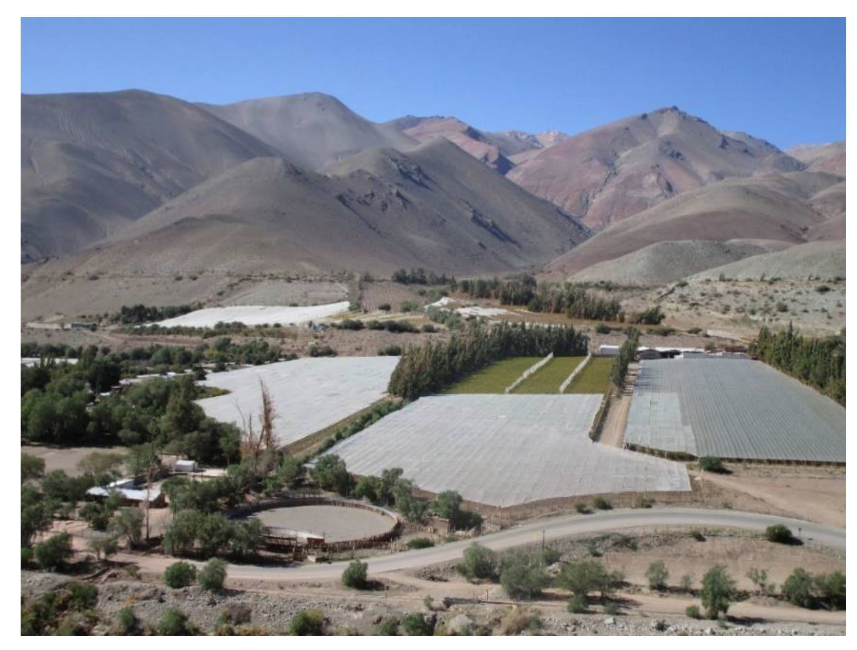
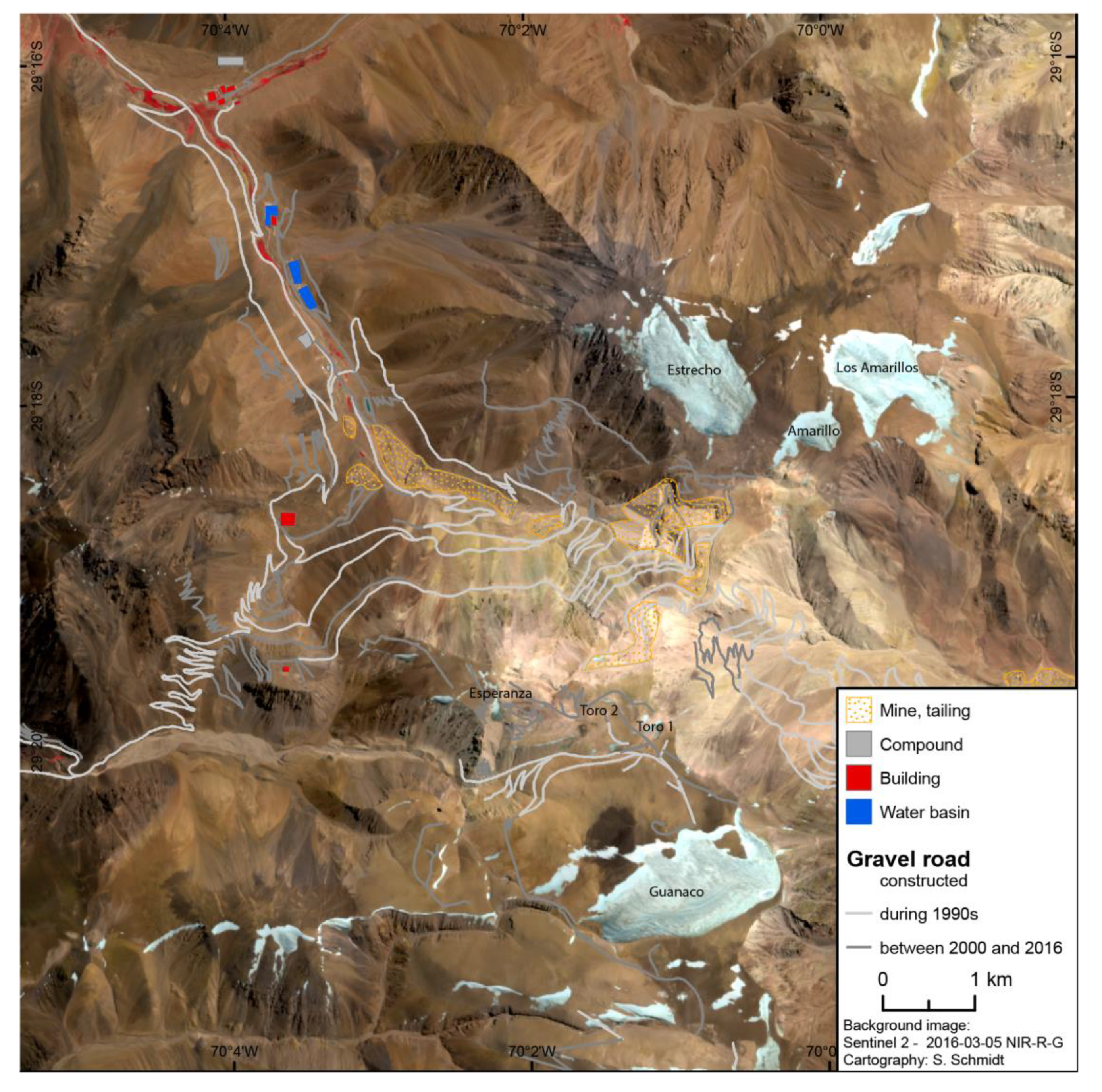
2. Study Area
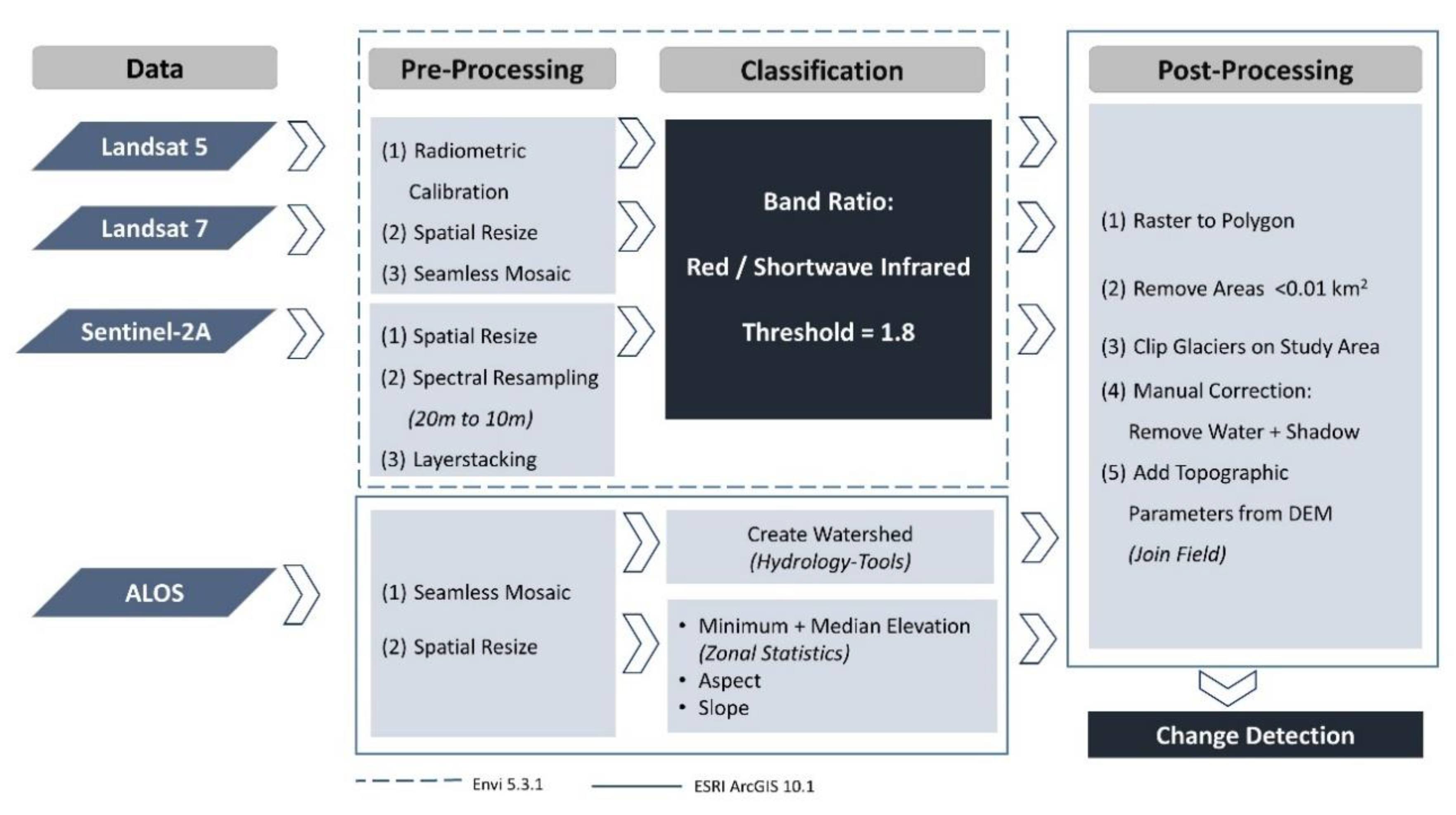
3. Materials and Methods
3.1. Data Selection and Preprocessing
3.2. Glacier Classification
3.3. Rock Glacier Mapping
4. Results
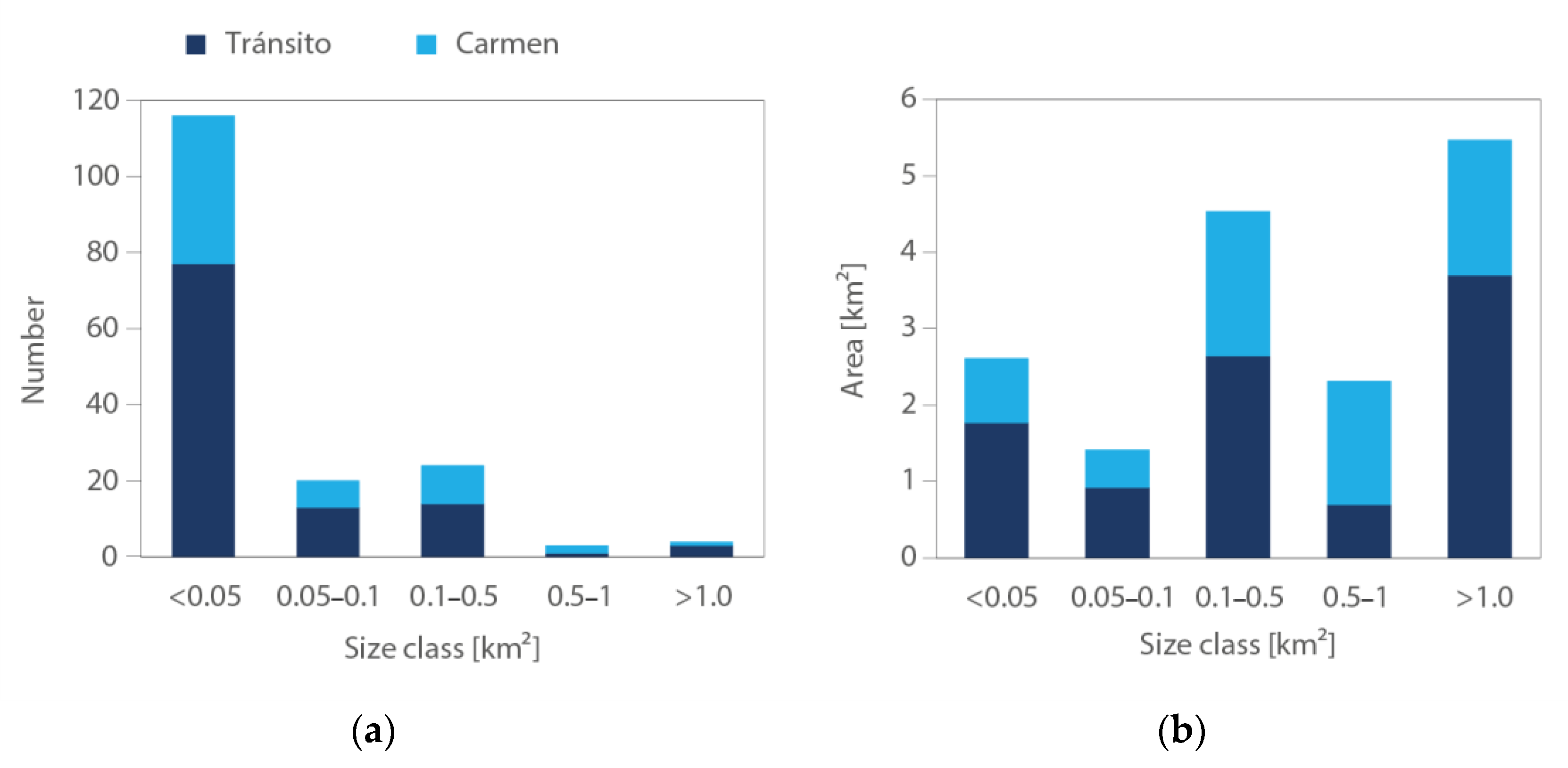
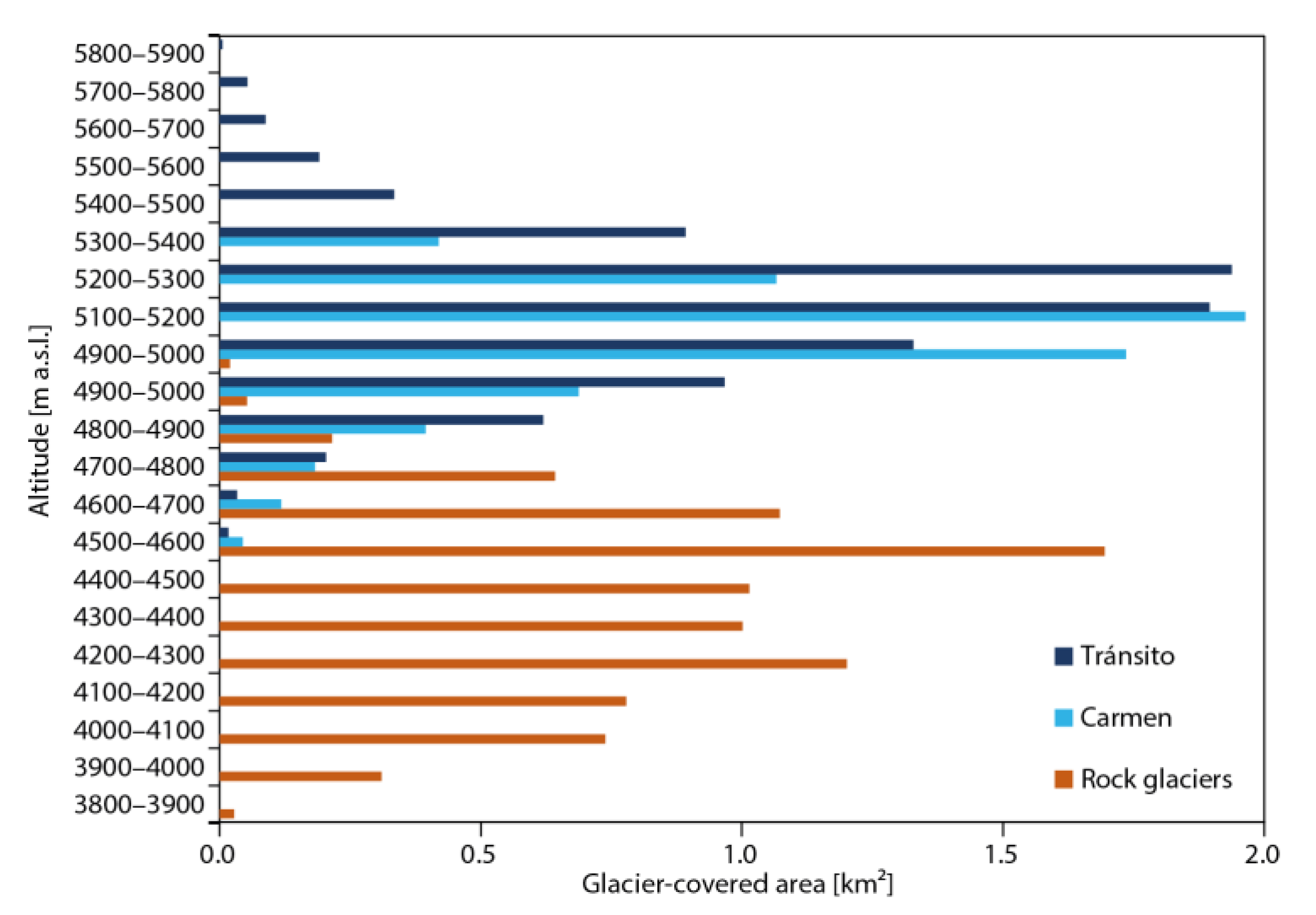
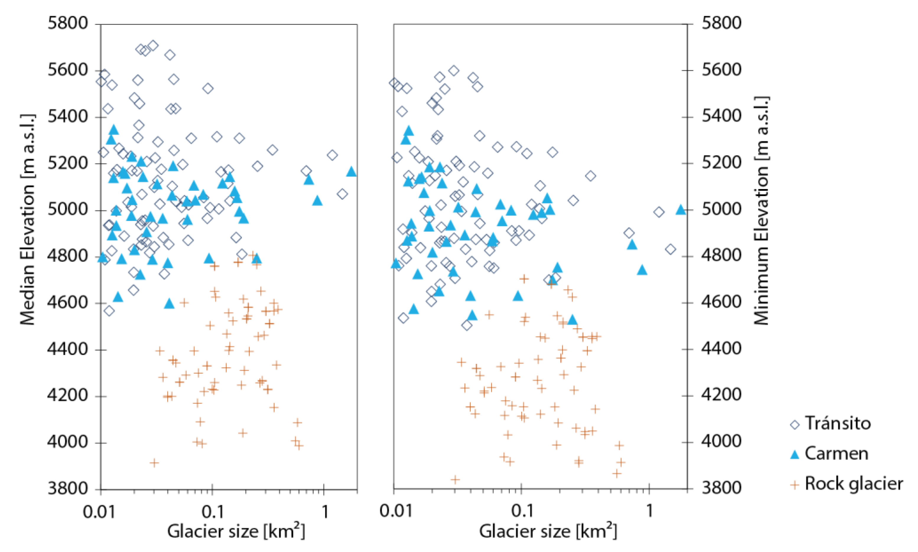
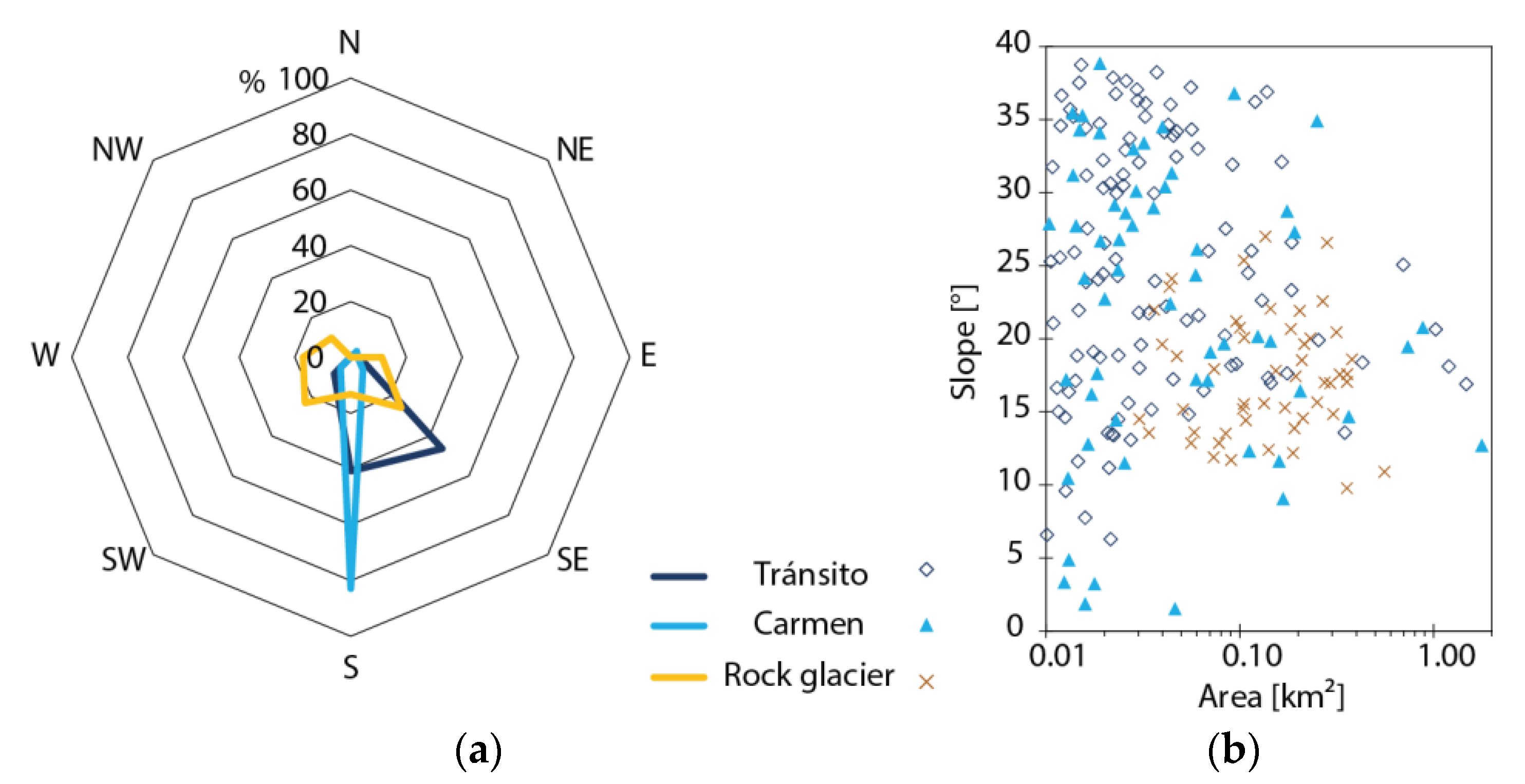
4.1. Glacier Inventory
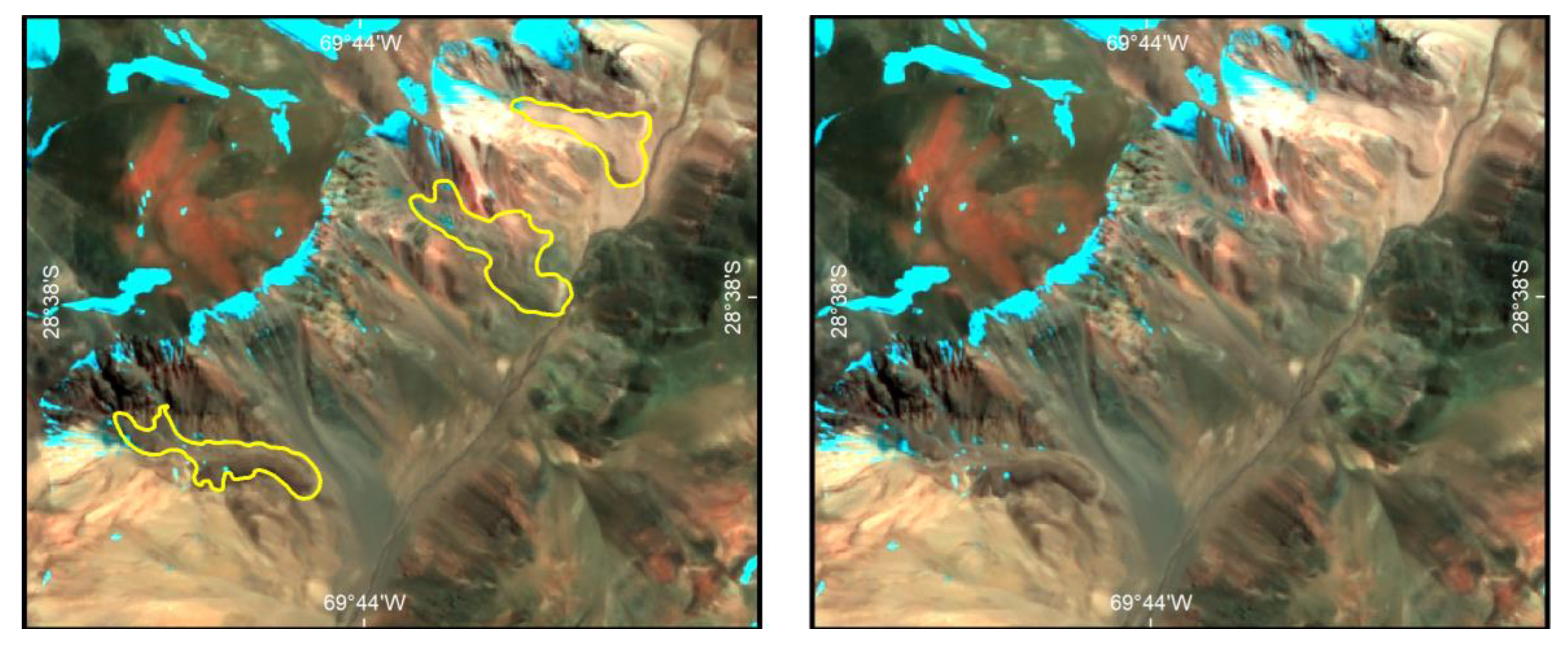
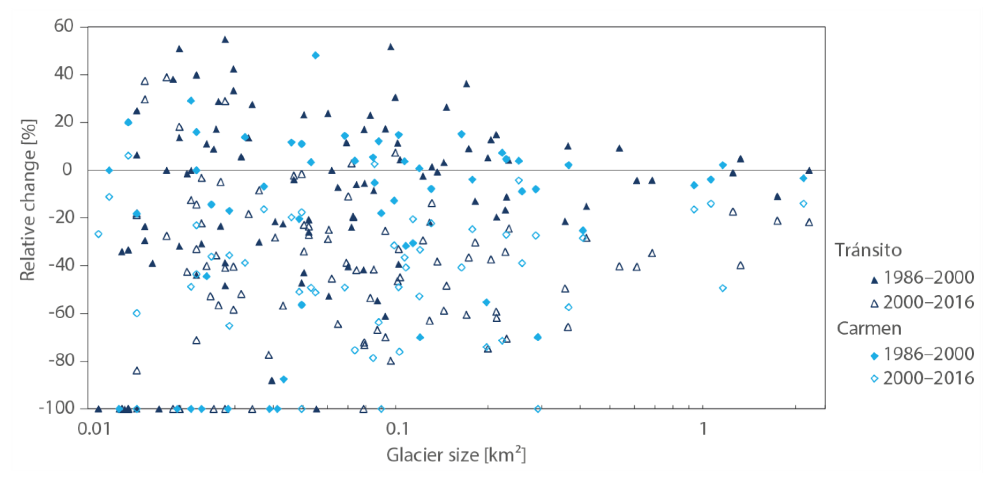
4.2. Glacier Changes
5. Discussion
5.1. Glacier and Rock Glacier Inventory from 2016
5.2. Glacier Change 1986–2016
6. Conclusions
Author Contributions
Funding
Acknowledgments
Conflicts of Interest
References
- Hock, R.; Rasul, G.; Adler, C.; Cáceres, B.; Gruber, S.; Hirabayashi, Y.; Jackson, M.; Kääb, A.; Kang, S.; Kutuzov, S.; et al. High Mountain Areas. In IPCC Special Report on the Ocean and Cryosphere in a Changing Climate (SROCC); 2019; Available online: https://www.ipcc.ch/srocc/chapter/chapter-2/ (accessed on 27 October 2020).
- Viviroli, D.; Dürr, H.H.; Messerli, B.; Meybeck, M.; Weingartner, R. Mountains of the world, water towers for humanity: Typology, mapping, and global significance. Water Resour. Res. 2007, 43, 1–13. [Google Scholar] [CrossRef] [Green Version]
- Viviroli, D.; Kummu, M.; Meybeck, M.; Kallio, M.; Wada, Y. Increasing dependence of lowland populations on mountain water resources. Nat. Sustain. 2020. [Google Scholar] [CrossRef]
- Valdés-Pineda, R.; Pizarro, R.; García-Chevesich, P.; Valdés, J.B.; Olivares, C.; Vera, M.; Balocchi, F.; Pérez, F.; Vallejos, C.; Fuentes, R.; et al. Water governance in Chile: Availability, management and climate change. J. Hydrol. 2014, 519, 2538–2567. [Google Scholar] [CrossRef]
- Larraín, S. Glaciares chilenos: Reservas estratégicas de agua dulce. Ambiente y Desarro. 2007, 23, 28–35. [Google Scholar]
- Magrin, G.O.; Marengo, J.A.; Boulanger, J.-P.; Buckeridge, M.S.; Castellanos, E.; Proveda, G.; Scarano, F.R.; Vicuña, S. Central and South America. In Proceedings of the IPCC; 2014; pp. 1499–1566. Available online: https://www.ipcc.ch/site/assets/uploads/2018/02/WGIIAR5-Chap27_FINAL.pdf (accessed on 27 October 2020).
- Brenning, A. Geomorphological, hydrological and climatic significance of rock glaciers in the Andes of Central Chile (33–35° S). Permafr. Periglac. Process. 2005, 16, 231–240. [Google Scholar] [CrossRef]
- Nicholson, L.; Marín, J.; Lopez, D.; Rabatel, A.; Bown, F.; Rivera, A. Glacier inventory of the upper Huasco valley, Norte Chico, Chile: Glacier characteristics, glacier change and comparison with central Chile. Ann. Glaciol. 2009, 50, 111–118. [Google Scholar] [CrossRef] [Green Version]
- Schaffer, N.; MacDonell, S.; Réveillet, M.; Yáñez, E.; Valois, R. Rock glaciers as a water resource in a changing climate in the semiarid Chilean Andes. Region. Environ. Chang. 2019, 19, 1263–1279. [Google Scholar] [CrossRef]
- Squeo, F.A.; Holmgren, M.; Jiménez, M.; Albán, L.; Reyes, J.; Gutiérrez, J.R. Tree establishment along an ENSO experimental gradient in the Atacama desert. J. Veg. Sci. 2007, 18, 195–202. [Google Scholar] [CrossRef]
- Vuille, M.; Milana, J.-P. High-latitude forcing of regional aridification along the subtropical west coast of South America. Geophys. Res. Lett. 2007, 34, 1–6. [Google Scholar] [CrossRef] [Green Version]
- Brenning, A. Climatic and Geomorphological Controls of Rock Glaciers in the Andes of Central Chile: Combining Statistical Modelling and Field Mapping. Ph.D. Thesis, Humboldt University, Berlin, Germany, 2005. [Google Scholar]
- Rosenblüth, B.; Fuenzalida, H.A.; Aceituno, P. Recent temperature variations in Southern South America. Int. J. Climatol. 1997, 17, 67–85. [Google Scholar] [CrossRef]
- Fiebig-Wittmaack, M.; Astudillo, O.; Wheaton, E.; Wittrock, V.; Perez, C.; Ibacache, A. Climatic trends and impact of climate change on agriculture in an arid Andean valley. Clim. Chang. 2012, 111, 819–833. [Google Scholar] [CrossRef]
- Huss, M.; Hock, R. Global-scale hydrological response to future glacier mass loss. Nat. Clim. Chang. 2018, 8, 135–140. [Google Scholar] [CrossRef] [Green Version]
- Urkidi, L. Movimientos anti-mineros: El caso de Pascua-Lama en Chile. Rev. Iberoam. Econ. Ecol. 2008, 8, 63–77. [Google Scholar]
- Urkidi, L. A glocal environmental movement against gold mining: Pascua–Lama in Chile. Ecol. Econ. 2010, 70, 219–227. [Google Scholar] [CrossRef]
- Li, F. Engineering responsibility: Environmental Mitigation and the Limits of Commensuration in a Chilean Mining Project. Focaal J. Glob. Hist. Anthropol. 2011, 60, 61–73. [Google Scholar] [CrossRef]
- Gascoin, S.; Kinnard, C.; Ponce, R.; Lhermitte, S.; MacDonell, S.; Rabatel, A. Glacier contribution to streamflow in two headwaters of the Huasco River, Dry Andes of Chile. Cryosphere 2011, 5, 1099–1113. [Google Scholar] [CrossRef] [Green Version]
- Garín, C. Inventario de glaciares de los Andes Chilenos desde los 18º a los 32º de Latitud Sur. Rev. Geogr. Norte Gd. 1987, 14, 35–48. [Google Scholar]
- Rivera, A.; Casassa, G.; Acuña, C.; Lange, H. Variaciones recientes de glaciares en Chile. Investig. Geogr. 2000, 29–60. [Google Scholar] [CrossRef] [Green Version]
- Rivera, A.; Acuña, C.; Casassa, G.; Bown, F. Use of remotely sensed and field data to estimate the contribution of Chilean glaciers to eustatic sea-level rise. Ann. Glaciol. 2002, 34, 367–372. [Google Scholar] [CrossRef] [Green Version]
- Rabatel, A.; Castebrunet, H.; Favier, V.; Nicholson, L.; Kinnard, C. Glacier changes in the Pascua-Lama region, Chilean Andes (29° S): Recent mass balance and 50 yr surface area variations. Cryosphere 2011, 5, 1029–1041. [Google Scholar] [CrossRef] [Green Version]
- Barcaza, G.; Nussbaumer, S.U.; Tapia, G.; Valdés, J.; García, J.-L.; Videla, Y.; Albornoz, A.; Arias, V. Glacier inventory and recent glacier variations in the Andes of Chile, South America. Ann. Glaciol. 2017, 58, 166–180. [Google Scholar] [CrossRef] [Green Version]
- Azócar, G.F.; Brenning, A. Hydrological and geomorphological significance of rock glaciers in the dry Andes, Chile (27°–33° S). Permafr. Periglac. Process. 2010, 21, 42–53. [Google Scholar] [CrossRef]
- Azócar, G.F.; Brenning, A.; Bodin, X. Permafrost distribution modelling in the semi-arid Chilean Andes. Cryosphere 2017, 11, 877–890. [Google Scholar] [CrossRef] [Green Version]
- Brenning, A.; Azócar, G.F. Statistical analysis of topographic and climatic controls and multispectral signatures of rock glaciers in the dry Andes, Chile (27°–33° S). Permafr. Periglac. Process. 2010, 21, 54–66. [Google Scholar] [CrossRef]
- Brenning, A.; Peña, M.A.; Long, S.; Soliman, A. Thermal remote sensing of ice-debris landforms using ASTER: An example from the Chilean Andes. Cryosphere 2012, 6, 367–382. [Google Scholar] [CrossRef] [Green Version]
- Kinnard, C.; Ginot, P.; Surazakov, A.; MacDonell, S.; Nicholson, L.; Patris, N.; Rabatel, A.; Rivera, A.; Squeo, F.A. Mass Balance and Climate History of a High-Altitude Glacier, Desert Andes of Chile. Front. Earth Sci. 2020, 8. [Google Scholar] [CrossRef]
- MacDonell, S.; Kinnard, C.; Mölg, T.; Nicholson, L.; Abermann, J. Meteorological drivers of ablation processes on a cold glacier in the semi-arid Andes of Chile. Cryosphere 2013, 7, 1513–1526. [Google Scholar] [CrossRef] [Green Version]
- Zang, C.; Dame, J.; Nüsser, M. Hydrochemical and environmental isotope analysis of groundwater and surface water in a dry mountain region in Northern Chile. Environ. Monit. Assess. 2018, 190, 1–19. [Google Scholar] [CrossRef] [PubMed]
- Salas, I.; Herrera, C.; Luque, J.A.; Delgado, J.; Urrutia, J.; Jordan, T. Recent climatic events controlling the hydrological and the aquifer dynamics at arid areas: The case of Huasco River watershed, northern Chile. Sci. Total Environ. 2016, 571, 178–194. [Google Scholar] [CrossRef]
- Kalthoff, N.; Bischoff-Gauß, I.; Fiebig-Wittmaack, M.; Fiedler, F.; Thürauf, J.; Novoa, E.; Pizarro, C.; Castillo, R.; Gallardo, L.; Rondanelli, R.; et al. Mesoscale Wind Regimes in Chile at 30° S. J. Appl. Meteor. 2002, 41, 953–970. [Google Scholar] [CrossRef]
- Pizarro, R.; Vera, M.; Valdés, R.; Helwig, B.; Olivares, C. Multi-decadal variations in annual maximum peak flows in semi-arid and temperate regions of Chile. Hydrol. Sci. J. 2014, 59, 300–311. [Google Scholar] [CrossRef] [Green Version]
- Fox, A.; Strecker, M. Pleistocene and modern snowlines in the Central Andes (24–28° S). Bamb. Geogr. Schr. 1991, 11, 169–182. [Google Scholar]
- Zech, R.; Kull, C.; Veit, H. Late Quaternary glacial history in the Encierro Valley, northern Chile (29° S), deduced from 10Be surface exposure dating. Palaeogeogr. Palaeoclimatol. Palaeoeco. 2006, 234, 277–286. [Google Scholar] [CrossRef]
- Montecinos, S.; Gutiérrez, J.R.; López-Cortés, F.; López, D. Climatic characteristics of the semi-arid Coquimbo Region in Chile. J. Arid Environ. 2016, 126, 7–11. [Google Scholar] [CrossRef]
- BCN. Reportes Estadísticos Comunales 2015: Comuna Alto del Carmen. Available online: http://reportescomunales.bcn.cl/2015/index.php/Alto_del_Carmen#N.C3.BAmero_de_trabajadores_por_rama_de_actividad_2009-2011-2013 (accessed on 17 July 2020).
- Oficina de Estudios y Políticas Agrarias & Centro de Información de Recursos Naturales. Principales Resultados Catastro Frutícola Región de Atacama. Resumen Nacional de la Superficie Frutícola. 2015. Available online: https://www.odepa.gob.cl/wp-content/uploads/2016/11/Atacama.pdf (accessed on 17 July 2020).
- Wagnitz, P.; Núñez, J.; Ribbe, L. Cost of environmental flow during water scarcity in the arid Huasco River basin, northern Chile. Hydrol. Sci. J. 2014, 59, 700–711. [Google Scholar] [CrossRef] [Green Version]
- Li, F. Moving Glaciers: Remaking Nature and Mineral Extraction in Chile. Lat. Am. Perspect. 2018, 45, 102–119. [Google Scholar] [CrossRef]
- Taillant, J.D. Glaciers. The Politics of Ice; Oxford University Press: New York, NY, USA, 2015; ISBN 9780199367252. [Google Scholar]
- Haslam, P.A.; Godfrid, J. Activists and regulatory politics: Institutional opportunities, information, and the activation of environmental regulation. Extr. Ind. Soc. 2020, 7, 1077–1085. [Google Scholar] [CrossRef]
- Brenning, A. The impact of mining on rock glaciers and glaciers: Examples from Central Chile. In Darkening Peaks; University of California Press: Berkeley, CA, USA, 2008; pp. 196–205. [Google Scholar]
- Kronenberg, J. Global Warming, Glaciers and Gold Mining. In Proceedings of the 8th International Conference of the European Society for Ecological Economics, Ljubljana, Slovenia, 29 June–2 July 2009; Available online: https://pdfs.semanticscholar.org/cc37/a583048b8f1d4ce29804f918b42608e3a628.pdf (accessed on 27 October 2020).
- French, A.; Barandiarán, J.; Rampini, C. Contextualizing conflict: Vital waters and competing values in glaciated environments. In The High-Mountain Cryosphere: Environmental Changes and Human Risks; Huggel, C., Carey, M., Clague, J.J., Kääb, A., Eds.; Cambridge University Press: Cambridge, UK, 2015; pp. 315–336. ISBN 978-1-107-06584-0. [Google Scholar]
- Haslam, P.A. The Two Sides of Pascua Lama: Social Protest, Institutional Responses, and Feedback Loops. Eur. Rev. Lat. Am. Caribb. Stud. 2018, 106, 157–182. [Google Scholar] [CrossRef]
- Pinto, J.; Prado, P.; Tirado-Alcaraz, J.A. Chile’s Pascua Lama: Where Water Is worth More than Gold. In 2017—Environmental News in South America; Springer: Berlin, Germany, 2017; pp. 115–141. [Google Scholar]
- Paul, F.; Bolch, T.; Kääb, A.; Nagler, T.; Nuth, C.; Scharrer, K.; Shepherd, A.; Strozzi, T.; Ticconi, F.; Bhambri, R.; et al. The glaciers climate change initiative: Methods for creating glacier area, elevation change and velocity products. Remote Sens. Environ. 2015, 162, 408–426. [Google Scholar] [CrossRef] [Green Version]
- Paul, F.; Barry, R.G.; Cogley, J.G.; Frey, H.; Haeberli, W.; Ohmura, A.; Ommanney, C.; Raup, B.; Rivera, A.; Zemp, M. Recommendations for the compilation of glacier inventory data from digital sources. Ann. Glaciol. 2009, 50, 119–126. [Google Scholar] [CrossRef] [Green Version]
- Paul, F.; Huggel, C.; Kääb, A.; Maisch, M. Comparison of TM-Derived Glacier Areas with Higher Resolution Data Sets. In EARSeL Workshop in Remote Sensing of Land Ice and Snow; 2003; pp. 15–21. Available online: http://eproceedings.uni-oldenburg.de/website/vol02_1/02_1_paul1.pdf (accessed on 27 October 2020).
- ESA. Sentinel-2 Operations. Available online: http://www.esa.int/Our_Activities/Operations/Sentinel-2_operations (accessed on 17 July 2020).
- Gardent, M.; Rabatel, A.; Dedieu, J.-P.; Deline, P. Multitemporal glacier inventory of the French Alps from the late 1960s to the late 2000s. Glob. Planet. Chang. 2014, 120, 24–37. [Google Scholar] [CrossRef]
- Tadono, T.; Nagai, H.; Ishida, H.; Oda, F.; Naito, S.; Minakawa, K.; Iwamoto, H. Generation of the 30 m-mesh global digital surface model by ALOS PRISM. Int. Arch. Photogramm. Remote Sens. Spat. Inf. Sci. 2016, 41, 157–162. [Google Scholar] [CrossRef]
- JAXA. ALOS Global Digital Surface Model “ALOS World 3D—30m” (AW3D30). Available online: http://www.eorc.jaxa.jp/ALOS/en/aw3d30/index.htm (accessed on 17 July 2020).
- USGS. Earthexplorer. Available online: https://earthexplorer.usgs.gov/ (accessed on 17 July 2020).
- ESA. Sentinel-2. Available online: https://scihub.copernicus.eu/dhus/#/home (accessed on 17 July 2020).
- Paul, F.; Barrand, N.E.; Baumann, S.; Berthier, E.; Bolch, T.; Casey, K.; Frey, H.; Joshi, S.P.; Konovalov, V.; Le Bris, R.; et al. On the accuracy of glacier outlines derived from remote-sensing data. Ann. Glaciol. 2013, 54, 171–182. [Google Scholar] [CrossRef] [Green Version]
- Racoviteanu, A.; Paul, F.; Raup, B.; Khalsa, S.; Armstrong, R. Challenges and recommendations in mapping of glacier parameters from space: Results of the 2008 Global Land Ice Measurements from Space (GLIMS) workshop, Boulder, Colorado, USA. Ann. Glaciol. 2009, 50, 53–69. [Google Scholar] [CrossRef] [Green Version]
- Paul, F.; Kääb, A. Perspectives on the production of a glacier inventory from multispectral satellite data in the Canadian Arctic: Cumberland Peninsula, Baffin Island. Ann. Glaciol. 2005, 42, 59–66. [Google Scholar] [CrossRef] [Green Version]
- Paul, F.; Huggel, C.; Kääb, A. Combining satellite multispectral image data and a digital elevation model for mapping debris-covered glaciers. Remote Sens. Environ. 2004, 89, 510–518. [Google Scholar] [CrossRef]
- Paul, F.; Winsvold, S.; Kääb, A.; Nagler, T.; Schwaizer, G. Glacier Remote Sensing Using Sentinel-2. Part II: Mapping Glacier Extents and Surface Facies, and Comparison to Landsat 8. Remote Sens. 2016, 8, 575. [Google Scholar] [CrossRef] [Green Version]
- Pfeffer, W.T.; Arendt, A.A.; Bliss, A.; Bolch, T.; Cogley, J.G.; Gardner, A.S.; Hagen, J.-O.; Hock, R.; Kaser, G.; Kienholz, C.; et al. The Randolph Glacier Inventory: A globally complete inventory of glaciers. J. Glaciol. 2014, 60, 537–552. [Google Scholar] [CrossRef] [Green Version]
- Schmidt, S.; Nüsser, M. Changes of High Altitude Glaciers from 1969 to 2010 in the Trans-Himalayan Kang Yatze Massif, Ladakh, Northwest India. Arct. Antarct. Alp. Res. 2012, 44, 107–121. [Google Scholar] [CrossRef]
- Granshaw, F.D.; Fountain, A.G. Glacier change (1958–1998) in the North Cascades National Park Complex, Washington, USA. J. Glaciol. 2006, 52, 251–256. [Google Scholar] [CrossRef] [Green Version]
- Bhambri, R.; Bolch, T.; Chaujar, R.K.; Kulshreshtha, S.C. Glacier changes in the Garhwal Himalaya, India, from 1968 to 2006 based on remote sensing. J. Glaciol. 2011, 57, 543–556. [Google Scholar] [CrossRef] [Green Version]
- Bolch, T.; Menounos, B.; Wheate, R. Landsat-based inventory of glaciers in western Canada, 1985–2005. Remote Sens. Environ. 2010, 114, 127–137. [Google Scholar] [CrossRef]
- Kamp, U.; Byrne, M.; Bolch, T. Glacier fluctuations between 1975 and 2008 in the Greater Himalaya Range of Zanskar, southern Ladakh. J. Mt. Sci. 2011, 8, 374–389. [Google Scholar] [CrossRef]
- Janke, J.R.; Bellisario, A.C.; Ferrando, F.A. Classification of debris-covered glaciers and rock glaciers in the Andes of central Chile. Geomorphology 2015, 241, 98–121. [Google Scholar] [CrossRef]
- Brenning, A. Benchmarking classifiers to optimally integrate terrain analysis and multispectral remote sensing in automatic rock glacier detection. Remote Sens. Environ. 2009, 113, 239–247. [Google Scholar] [CrossRef]
- Müller, J.; Vieli, A.; Gärtner-Roer, I. Rock glaciers on the run–understanding rock glacier landform evolution and recent changes from numerical flow modeling. Cryosphere 2016, 10, 2865–2886. [Google Scholar] [CrossRef] [Green Version]
- Roer, I.; Nyenhuis, M. Rockglacier activity studies on a regional scale: Comparison of geomorphological mapping and photogrammetric monitoring. Earth Surf. Process. Landf. 2007, 32, 1747–1758. [Google Scholar] [CrossRef]
- Bodin, X.; Rojas, F.; Brenning, A. Status and evolution of the cryosphere in the Andes of Santiago (Chile, 33.5° S.). Geomorphology 2010, 118, 453–464. [Google Scholar] [CrossRef]
- Haeberli, W.; Hallet, B.; Arenson, L.; Elconin, R.; Humlum, O.; Kääb, A.; Kaufmann, V.; Ladanyi, B.; Matsuoka, N.; Springman, S.; et al. Permafrost creep and rock glacier dynamics. Permafr. Periglac. Process. 2006, 17, 189–214. [Google Scholar] [CrossRef]
- Kääb, A. Permafrost and Periglacial Features: Rock Glaciers and Protalus Forms. In Encyclopedia of Quaternary Science, 2nd ed.; Mock, C.J., Elias, S.A., Eds.; Elsevier: Edinburgh, UK, 2013; pp. 535–541. ISBN 9780444536426. [Google Scholar]
- Pellicciotti, F.; Ragettli, S.; Carenzo, M.; McPhee, J. Changes of glaciers in the Andes of Chile and priorities for future work. Sci. Total Environ. 2014, 493, 1197–1210. [Google Scholar] [CrossRef]
- Paul, F.; Svoboda, F. A new glacier inventory on southern Baffin Island, Canada, from ASTER data: II. Data analysis, glacier change and applications. Ann. Glaciol. 2009, 50, 22–31. [Google Scholar] [CrossRef] [Green Version]
- Gascoin, S.; Lhermitte, S.; Kinnard, C.; Bortels, K.; Liston, G.E. Wind effects on snow cover in Pascua-Lama, Dry Andes of Chile. Adv. Water Resour. 2013, 55, 25–39. [Google Scholar] [CrossRef] [Green Version]
- Masiokas, M.H.; Christie, D.A.; Le Quesne, C.; Pitte, P.; Ruiz, L.; Villalba, R.; Luckman, B.H.; Berthier, E.; Nussbaumer, S.U.; González-Reyes, Á.; et al. Reconstructing the annual mass balance of the Echaurren Norte glacier (Central Andes, 33.5° S) using local and regional hydroclimatic data. Cryosphere 2016, 10, 927–940. [Google Scholar] [CrossRef] [Green Version]
- Dussaillant, I.; Berthier, E.; Brun, F.; Masiokas, M.; Hugonnet, R.; Favier, V.; Rabatel, A.; Pitte, P.; Ruiz, L. Two decades of glacier mass loss along the Andes. Nat. Geosci. 2019, 12, 802–808. [Google Scholar] [CrossRef]
- Malmros, J.K.; Mernild, S.H.; Wilson, R.; Yde, J.C.; Fensholt, R. Glacier area changes in the central Chilean and Argentinean Andes 1955–2013/14. J. Glaciol. 2016, 62, 391–401. [Google Scholar] [CrossRef] [Green Version]
- Ruiz Pereira, S.F.; Veettil, B.K. Glacier decline in the Central Andes (33° S): Context and magnitude from satellite and historical data. J. S. Am. Earth Sci. 2019, 94, 102249. [Google Scholar] [CrossRef]
- Carrasco, J.F.; Casassa, G.; Quintana, J. Changes of the 0 °C isotherm and the equilibrium line altitude in central Chile during the last quarter of the 20th century/Changements de l’isotherme 0 °C et de la ligne d’équilibre des neiges dans le Chili central durant le dernier quart du 20ème siècle. Hydrol. Sci. J. 2005, 50, 661. [Google Scholar] [CrossRef]
- Boisier, J.P.; Rondanelli, R.; Garreaud, R.D.; Muñoz, F. Anthropogenic and natural contributions to the Southeast Pacific precipitation decline and recent megadrought in central Chile. Geophys. Res. Lett. 2016, 43, 413–421. [Google Scholar] [CrossRef] [Green Version]
- Corripio, J.G.; Purves, R.S. Surface Energy Balance of High Altitude Glaciers in the Central Andes: The Effect of Snow Penitentes. In Climate and Hydrology in Mountain Areas; Jong, C.d., Collins, D., Ranzi, R., Eds.; Wiley: Hoboken, NJ, USA, 2010; pp. 15–27. ISBN 9780470858240. [Google Scholar]
- Barandiarán, J. Documenting rubble to shift baselines: Environmental assessments and damaged glaciers in Chile. Environ. Plan. E 2020, 3, 58–75. [Google Scholar] [CrossRef]
- Bellisario, A.; Ferrando, F.; Janke, J. Water resources in Chile: The critical relation between glaciers and mining for sustainable water management. Investig. Geogr. Chile 2013, 46, 3–24. [Google Scholar] [CrossRef] [Green Version]
- Nüsser, M. Socio-hydrology: A New Perspective on Mountain Waterscapes at the Nexus of Natural and Social Processes. Mt. Res. Dev. 2017, 37, 518–520. [Google Scholar] [CrossRef]


| Satellite Type | Acquisition Date | Scene ID | Spectral and Spatial Resolution |
|---|---|---|---|
| (m × m) | |||
| 17 March 1986 | LT05L1TP2330801986031720170218 | VIS, NIR, SWIR: | |
| Landsat 5 1 | 17 March 1986 | LT05L1TP2330811986031720170218 | 30 |
| 31 March 2000 | LE07L1TP2330802000033120170212 | VIS, NIR, SWIR: | |
| Landsat 7 1 | 31 March 2000 | LE07L1TP2330812000033120170212 | 30 |
| Sentinel-2A 2 | 5 March 2016 | S2AOPERPRDMSIL1CPDMC20160308T17 3710R096V20160305T14431620160305T144316 | VIS, NIR: 10, SWIR: 20 |
| 1986 | 2000 | 2000–1986 | 2016 | 2016–1986 | 2016–2000 | ||||||||||||||
|---|---|---|---|---|---|---|---|---|---|---|---|---|---|---|---|---|---|---|---|
| N | km2 | (%) | N | (km2) | (%) | (km2) | (%) | (% a−1) | N | (km2) | (%) | (km2) | (%) | (% a−1) | (km2) | (%) | (% a−1) | ||
| total glacier-covered area | total | 162 | 26.11 ± 5.35 | 100.0 | 152 | 24.99 ± 5.15 | 100.0 | −1.12 | −2.0 | −0.1 | 167 | 16.35 ± 3.06 | 100.0 | −9.76 | −38.5 | −1.3 | −8.64 | −35.6 | −2.2 |
| >1 | 7 | 10.91 ± 1.07 | 41.8 | 7 | 10.69 ± 1.06 | 42.8 | −2.3 | −0.2 | 4 | 5.47 ± 0.4 | 33.5 | −49.9 | −1.7 | −48.8 | −3.1 | ||||
| 0.5–1.0 | 4 | 2.77 ± 0.41 | 10.6 | 4 | 2.71 ± 0.41 | 10.8 | −8.2 | −0.6 | 3 | 2.31 ± 0.21 | 14.1 | −16.5 | −0.5 | −14.5 | −0.9 | ||||
| 0.1–0.5 | 41 | 8.06 ± 1.98 | 30.9 | 39 | 7.4 ± 1.8 | 29.6 | −4.8 | −0.3 | 24 | 4.54 ± 0.92 | 27.7 | −43.8 | −1.5 | −38.7 | −2.4 | ||||
| 0.05–0.1 | 33 | 2.44 ± 0.87 | 9.3 | 32 | 2.32 ± 0.85 | 9.3 | −3.0 | −0.2 | 20 | 1.42 ± 0.43 | 8.7 | −41.9 | −1.4 | −39.0 | −2.4 | ||||
| <0.05 | 77 | 1.93 ± 1.02 | 7.4 | 72 | 1.87 ± 1.01 | 7.5 | −2.0 | −0.1 | 116 | 2.61 ± 1.11 | 16.0 | 35.8 | 1.2 | 40.0 | 2.5 | ||||
| Tránsito | total | 104 | 15.3 ± 3.34 | 59.9 | 101 | 13.86 ± 3.15 | 61.4 | −1.44 | −1.8 | −0.1 | 106 | 9.64 ± 1.89 | 59.0 | −5.66 | −37.4 | −1.2 | −4.22 | −34.6 | −2.2 |
| >1 | 4 | 6.56 ± 0.67 | 25.1 | 4 | 5.18 ± 0.53 | 25.7 | −2.1 | −0.1 | 3 | 2.67 ± 0.21 | 22.6 | −38.3 | −1.3 | −37.2 | −2.3 | ||||
| 0.5–1.0 | 3 | 1.83 ± 0.33 | 7.0 | 3 | 1.83 ± 0.33 | 7.3 | −0.2 | 0.0 | 1 | 0.70 ± 0.09 | 4.3 | −43.6 | −1.5 | −42.4 | −2.6 | ||||
| 0.1–0.5 | 22 | 4.31 ± 1.08 | 16.5 | 25 | 4.31 ± 1.08 | 18.1 | 5.3 | 0.4 | 14 | 2.64 ± 0.51 | 16.1 | −61.9 | −2.1 | −61.8 | −3.9 | ||||
| 0.05–0.1 | 24 | 1.74 ± 0.60 | 6.7 | 17 | 1.20 ± 0.44 | 4.8 | −31.2 | −2.2 | 12 | 0.85 ± 0.27 | 5.2 | −38.7 | −1.3 | −41.8 | −2.6 | ||||
| <0.05 | 51 | 1.19 ± 0.65 | 4.6 | 52 | 1.37 ± 0.75 | 5.5 | 14.7 | 1.1 | 76 | 1.75 ± 0.72 | 10.7 | −51.0 | −1.7 | −28.8 | −1.8 | ||||
| Carmen | total | 58 | 10.48 ± 1.40 | 40.1 | 53 | 9.64 ± 1.82 | 38.6 | −0.84 | −8.0 | −0.6 | 59 | 6.63 ± 0.57 | 40.5 | −3.85 | 46.5 | 1.6 | −3.01 | 27.7 | 1.7 |
| >1 | 3 | 4.36 ± 0.40 | 16.7 | 3 | 4.27 ± 0.41 | 17.1 | −2.0 | −0.1 | 1 | 1.77 ± 1.00 | 10.8 | −36.8 | −1.2 | −31.3 | −2.0 | ||||
| 0.5–1.0 | 1 | 0.94 ± 0.08 | 3.6 | 1 | 0.88 ± 0.08 | 3.5 | −6.3 | −0.4 | 2 | 1.62 ± 0.11 | 9.9 | −59.3 | −2.0 | −58.5 | −3.7 | ||||
| 0.1–0.5 | 19 | 3.76 ± 0.89 | 14.4 | 14 | 2.87 ± 0.66 | 11.5 | −23.7 | −1.7 | 10 | 1.90 ± 0.41 | 11.6 | 72.1 | 2.4 | 83.7 | 5.2 | ||||
| 0.05–0.1 | 9 | 0.70 ± 0.27 | 2.7 | 15 | 1.12 ± 0.41 | 4.5 | 61.0 | 4.4 | 7 | 0.49 ± 0.15 | 3.0 | −49.6 | −1.7 | −33.9 | −2.1 | ||||
| <0.05 | 26 | 0.73 ± 0.37 | 2.8 | 20 | 0.50 ± 0.26 | 2.0 | −32.0 | −2.3 | 39 | 0.85 ± 0.38 | 5.2 | −29.1 | −1.0 | −55.9 | −3.5 | ||||
Publisher’s Note: MDPI stays neutral with regard to jurisdictional claims in published maps and institutional affiliations. |
© 2020 by the authors. Licensee MDPI, Basel, Switzerland. This article is an open access article distributed under the terms and conditions of the Creative Commons Attribution (CC BY) license (http://creativecommons.org/licenses/by/4.0/).
Share and Cite
Hess, K.; Schmidt, S.; Nüsser, M.; Zang, C.; Dame, J. Glacier Changes in the Semi-Arid Huasco Valley, Chile, between 1986 and 2016. Geosciences 2020, 10, 429. https://doi.org/10.3390/geosciences10110429
Hess K, Schmidt S, Nüsser M, Zang C, Dame J. Glacier Changes in the Semi-Arid Huasco Valley, Chile, between 1986 and 2016. Geosciences. 2020; 10(11):429. https://doi.org/10.3390/geosciences10110429
Chicago/Turabian StyleHess, Katharina, Susanne Schmidt, Marcus Nüsser, Carina Zang, and Juliane Dame. 2020. "Glacier Changes in the Semi-Arid Huasco Valley, Chile, between 1986 and 2016" Geosciences 10, no. 11: 429. https://doi.org/10.3390/geosciences10110429
APA StyleHess, K., Schmidt, S., Nüsser, M., Zang, C., & Dame, J. (2020). Glacier Changes in the Semi-Arid Huasco Valley, Chile, between 1986 and 2016. Geosciences, 10(11), 429. https://doi.org/10.3390/geosciences10110429