Article

Analysis of the Possible Reactivation of the Krbavčići Landslide in Northern Istria, Croatia

by
Martina Vivoda Prodan
* and
Željko Arbanas
Faculty of Civil Engineering, University of Rijeka, Radmile Matejčić 3, 51 000 Rijeka, Croatia
*
Author to whom correspondence should be addressed.
Geosciences 2020, 10(8), 294; https://doi.org/10.3390/geosciences10080294
Submission received: 12 June 2020 / Revised: 14 July 2020 / Accepted: 22 July 2020 / Published: 31 July 2020
(This article belongs to the Section Natural Hazards)

Abstract

:
The Krbavčići landslide occurred in January 1979 near the town of Buzet, Croatia, after a long period of heavy rainfall. It is located in Northern Istria in the area built of flysch rock mass where numerous mass movements in the past and recent history have been recorded. A flysch rock mass is highly susceptible to weathering, which leads to material disintegration, changes in geotechnical properties, and shear strength decrease, finally resulting in instability processes in flysch slopes. This paper describes existing information about the Krbavčići landslide occurrence, laboratory testing of siltstone samples from a flysch rock mass, and numerical slope stability analyses of a possible landslide reactivation caused by possible long rainy periods and further weathering of the flysch rock mass. Slope stability analysis using the Rocscience, Slide software, as well as landslide numerical simulations using the LS-Rapid simulation software were performed on the basis of the digital elevation model (DEM) and laboratory test results of siltstones with different weathering grades. A DEM of the Krbavčići landslide was obtained on the basis of the unmanned aerial vehicle (UAV) survey conducted in March 2016. The residual shear strength of siltstones to predict a reactivation of landslides is of highest importance and was determined by ring shear and direct shear tests on siltstone samples with different weathering grades. The results of the numerical simulations show that an increase of the groundwater level in the landslide body in combination with the further weathering of the flysch rock material at the sliding surface would have the main influence on a possible landslide reactivation and the further development of the landslide displacement.

1. Introduction

The Krbavčići landslide occurred in January 1979 near the town of Buzet, Croatia, after a long period of heavy rainfall. It is located in the northern part of the Istrian peninsula; an area consisting of Paleogene flysch, limestone from the Cretaceous, and Jurassic period and alluvial deposits (Figure 1) [1].
In the study area, the flysch rock mass is characterized by lithological heterogeneity, as the lithological sequences show common vertical and lateral alterations that include marls, siltstones, and fine-grained sandstones, as well as distinct calcarenite layers (Figure 2).
A flysch rock mass can have different physical and mechanical properties depending on its lithological composition and weathering grade. Weathering processes are particularly evident in incompetent members, such as claystone, shales, and siltstones. In contrast, sandstones, limestone, and breccia-conglomerates are competent members and are considerably more resistant to the effects of exogenetic forces [3].
This study is focused on siltstones, which are the component of the flysch complex, characterized by high erodibility, low durability, and high susceptibility to weathering. Therefore, the mechanical behavior of siltstones has the greatest influence on the behavior of the whole flysch rock mass complex. Figure 3 shows the high degradation of a flysch rock mass due to weathering in flysch pillars that were exposed to atmospheric conditions for seven years. These processes gradually transformed the fresh rock mass into residual soil, causing changes in its mineralogical composition and a reduction in its mechanical properties, which led to many landslides that occurred in this region in the past. Mainly rotational and translational landslides occurred with sliding surfaces located at the contact between the surficial deposits and the flysch bedrock, within the colluvium surficial deposits, or through the flysch rock mass [4,5]. The occurrence of debris flows has also been recorded in this area [6]. Different intensive erosion processes are also observed in the flysch deposits in the study area [7,8]. Many studies have investigated the effects of weathering on the strength of the flysch rock masses [9,10,11,12,13,14], as well as the hydro-mechanical properties of the soil in the unsaturated zone of the flysch slopes [15,16,17,18,19].
Numerous authors have investigated triggers of slope instabilities in soft rocks such as flysch rock mass [20,21] and have performed slope stability analyses of flysch slopes that are susceptible to weathering processes causing a decrease in material strength [22,23,24,25,26,27,28,29,30,31,32,33,34,35,36,37].
Digital photogrammetry using the structure from motion (SfM) technique with a high-resolution digital camera mounted on an unmanned aerial vehicle (UAV) [38] provides a 3D model from a sequence of multi-view captured images [39]. UAVs are now used for the analysis of landslide phenomena [39,40,41,42,43,44,45,46], coastal engineering [47,48,49,50,51], structural mapping [52,53,54,55], agriculture [56], etc. The use of UAVs has shown great potential in the last decade for the management of natural hazard events, their detection and monitoring, such as landslides, floods, earthquakes, volcanic activity, and forest wildfires [38].
In this paper, the weathering process of flysch rock mass and influence of possible long-term rain periods on the Krbavčići landslide reactivation is analyzed. Numerical 2D slope stability and 3D landslide simulations were carried out based on the input parameters obtained by ring shear and direct shear tests on siltstone samples from flysch rock mass of different weathering grades. Data of the current slope topography were provided by the UAV, using SfM photogrammetry to derive the 3D point cloud.

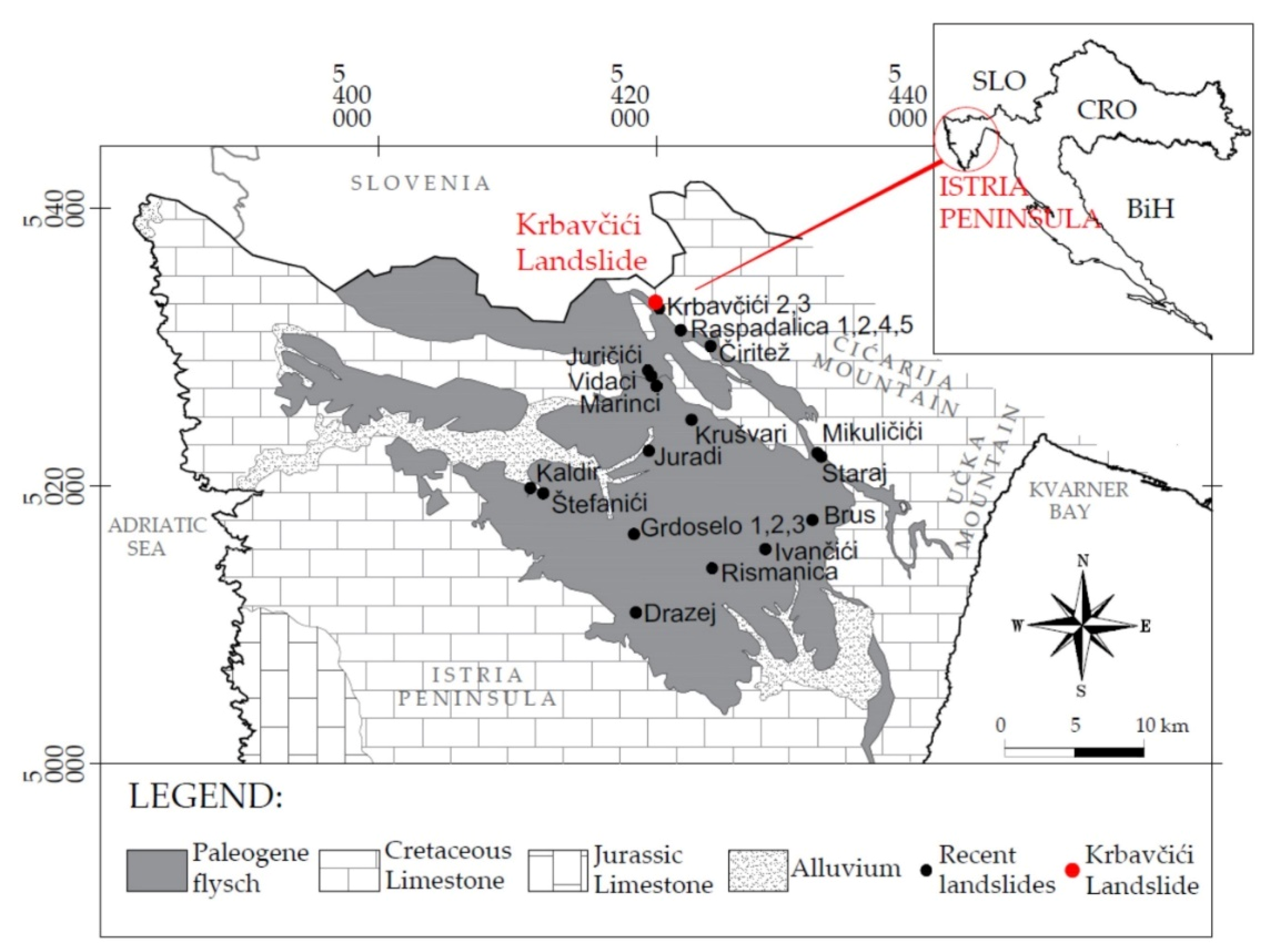
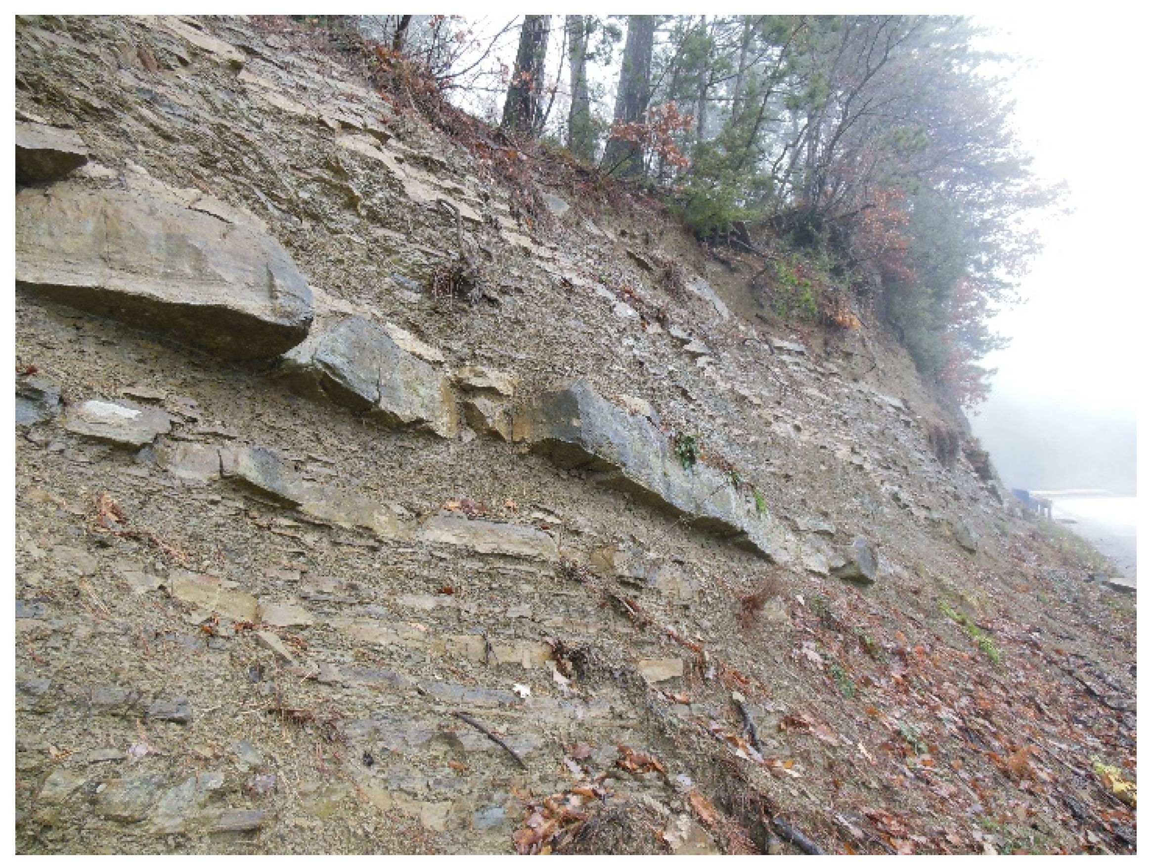
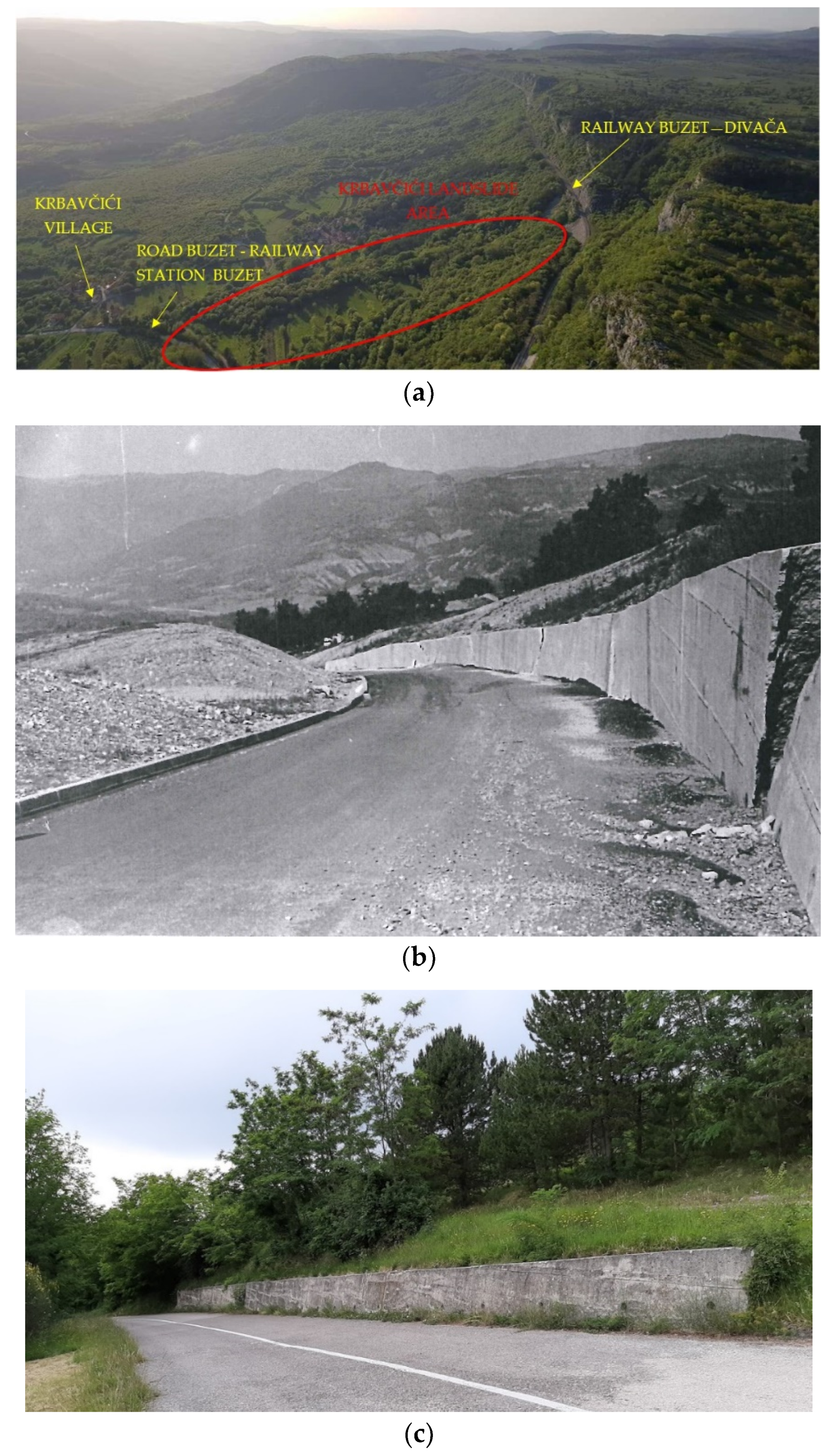
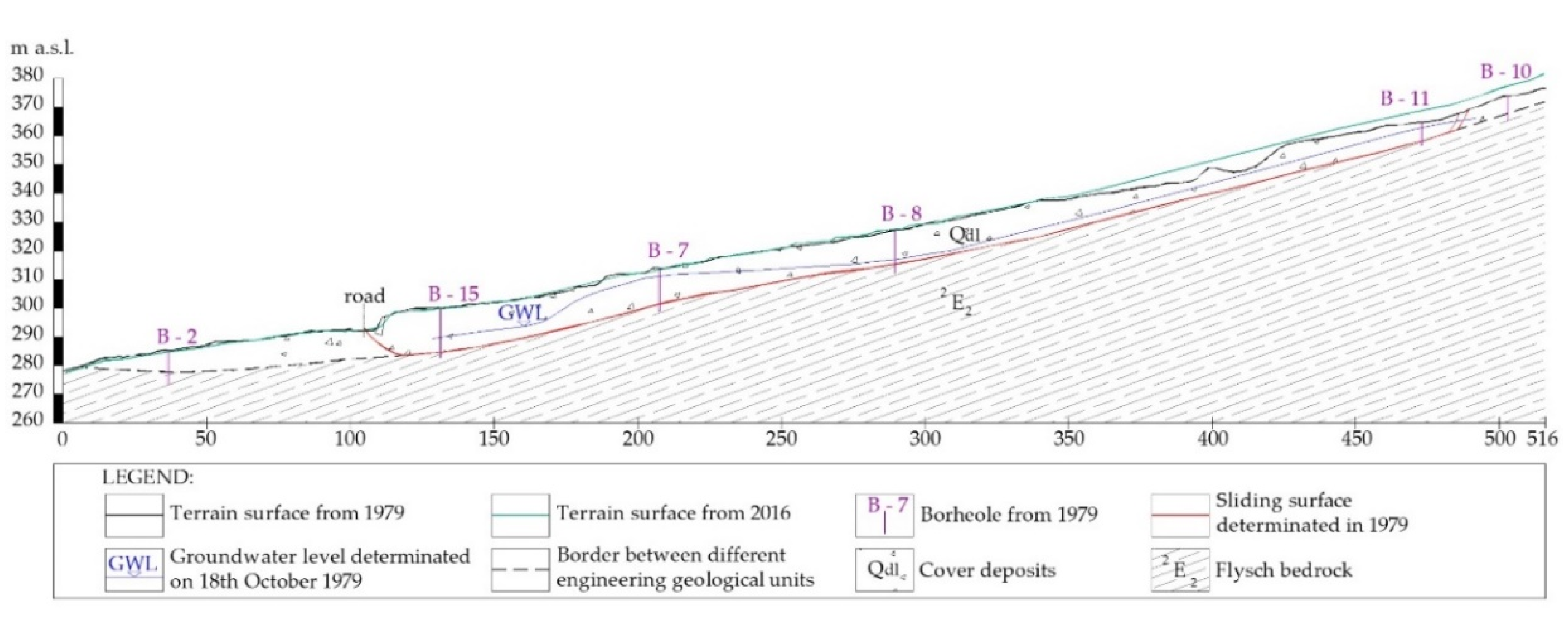
2. Description of the Krbavčići Landslide

The Krbavčići landslide occurred at the end of January 1979 near the town of Buzet, Croatia, after a long period of heavy rainfall. The landslide included terrain from the foot of the railway Buzet–Divača to the road Buzet–railway station (Figure 4a). The biggest damage occurred on the newly built road where the pavement was deformed and the retaining wall at the foot of the landslide was damaged (Figure 4b). According to memories of the Krbavčići village residents, the retaining wall was founded on the talus instead of in flysch rock mass. After a major slide, a new stable landslide position was taken, and no further displacements were observed (Figure 4c).
Longer rainfall events are critical for a landslide initiation, while short and intensive rainfall events play a greater role in the erosion processes. Dugonjić Jovančević and Arbanas [2] have shown that the cumulative twelve-month values, as well as the maximum monthly, weekly, or daily precipitation which precede sliding, do not have significant influence on a landslide initiation. Their analyses provide evidence that the precipitation from approximately three months before a landslide initiation has the primary influence on the rising infiltration and ground water level as the main triggering factor for the activation of landslides on flysch slopes in North Istria. The monthly and annual rainfall amounts in the period from 1961 to 2017 were observed and taken from the Abrami rain gauge (85 m a.s.l.), approximately 5 km away from the Krbavčići landslide. As it is shown in Figure 5, November is the rainiest month with the mean rainfall amount of 132.15 mm in the period 1961–2017. The rainfall amount in January 1979 reached 266.80 mm. The crucial three month cumulative rainfall amount, which triggered the Krbavčići landslide at the end of January 1979, was 479.1 mm.
The digital elevation model (DEM) of the Krbavčići landslide was derived from SfM photogrammetry, which was carried out in March 2016. A Sony Alpha 7R digital camera was used on an unmanned aerial vehicle (UAV) with a Real Time Kinematic (RTK) positioning system. The data are linked in the Croatian national coordinate system HTRS96/TM using the HVRS71 geoid. The result was the digital orthophoto map with 1 cm resolution, as shown in Figure 6b.
The field investigation carried out in summer 1979 consisted of geological mapping and drilling of 15 boreholes (Figure 6a) and is documented in the Geotechnical elaborate of the Krbavčići landslide [57]. Landslide head and flanks were clearly visible due to main scarp, and the transverse and radial cracks and moved material in the landslide toe are also visible. The identified landslide dimensions according to WP/WLI [58] are 370 m long, 30 m wide in the upper part, and 150 m in the lower part. The investigation indicated the sliding surface at a depth of approximately 13 m, within the weathered bedrock zone, at the contact between the weathered and fresh flysch rock mass. The engineering–geological cross-section of the landslide determined in 1979 is shown in Figure 7. According to Skempton and Hutchinson [59], it is classified as a translational landslide, and as a rock planar slide according to Hungr et al. [60], while the style was moderately moving according to Cruden and Varnes [61]. The landslide can now be considered as a dormant landslide because after initial sliding, no movements were visible at the local road or remains of the retaining wall (Figure 4b).
Atmospheric activity and unfavorable hydrological conditions led to weathering of the flysch rock mass, which altered its geotechnical and shear strength properties and formed potentially unstable deposits. The six standard grades of siltstone weathering were investigated in a flysch weathering profile (Figure 8) defined by the following categories: Fresh (FR), slightly weathered (SW), moderately weathered (MW), highly weathered (HW), and completely weathered (CW) rock masses and residual soil (RS). Vivoda Prodan and Arbanas [12], Vivoda Prodan [13], and Vivoda Prodan et al. [14] evaluated the weathering profile in the study area based on a qualitative description of the colors and discoloration, the discontinuity conditions, the presence or absence of the original rock texture, and the uniaxial compressive strength of the intact rock based on the Schmidt hammer rebound value.
Vivoda Prodan et al. [14] performed X-ray diffraction mineralogical analyses of siltstone samples of four different weathering grades, including I (FR), III (MW), V (CW), and VI (RS), taken from the flysch outcrop shown in Figure 8. The siltstone samples of different weathering grades consisted of small amounts of quartz and calcite, negligible amounts of plagioclase, and major amounts of clay minerals. On the basis of dissolution (calcite and chlorite) and comparison with standard diffractograms, the mineralogical composition of the samples (Figure 9a) was defined as follows: Calcite (35–50%), quartz (5–10%), plagioclase (up to 10%), K-feldspar (traces), and clay minerals (40–55%). Calcite, quartz, and phyllosilicates constituted 93–97% of the mineralogical composition, with phyllosilicates being the predominant minerals. Figure 9a shows the mineralogical content of siltstones according to the weathering grade where clay mineral content increased, and calcite content decreased with increasing weathering grades. The most important clay minerals were illite and chlorite, with trace amounts of kaolinite and mixed layer minerals (Figure 9b), where an increase in chlorite and illite content is visible with increasing weathering grades.
The results of mineralogical analyzes performed by Vivoda Prodan et al. [14] were compared to previous mineralogical data from flysch samples from the Krbavčići landslide in Northern Istria and the nearby area analyzed by Arbanas et al. [6]. The samples consisted of the minerals shown in Figure 9c: Calcite (13–36%), quartz (13–26%), plagioclase (up to 5%), and phyllosilicates (48–65%). The analyses revealed higher concentrations of clay minerals (muscovite and illite) in the sample taken from the landslide area compared to the other analyzed samples. The clay mineral content also increased, and the calcite content decreased with increasing weathering grades. The results from previous studies [6] and newly undertaken studies [14] in the same geological deposit are consistent with one another.

3. Methodology

The aim of this article is to discuss and identify the influence of changes in the geotechnical properties of siltstones due to long-term weathering processes on the Krbavčići landslide reactivation case study. Siltstone samples of different weathering grades taken from the flysch rock mass were subjected to laboratory tests to obtain data on their geotechnical properties. Subsequently, these geotechnical parameters of siltstones with different weathering grades were used in the 2D and 3D numerical analysis of the landslide reactivation. Details about the applied methodology are described in the following sections.

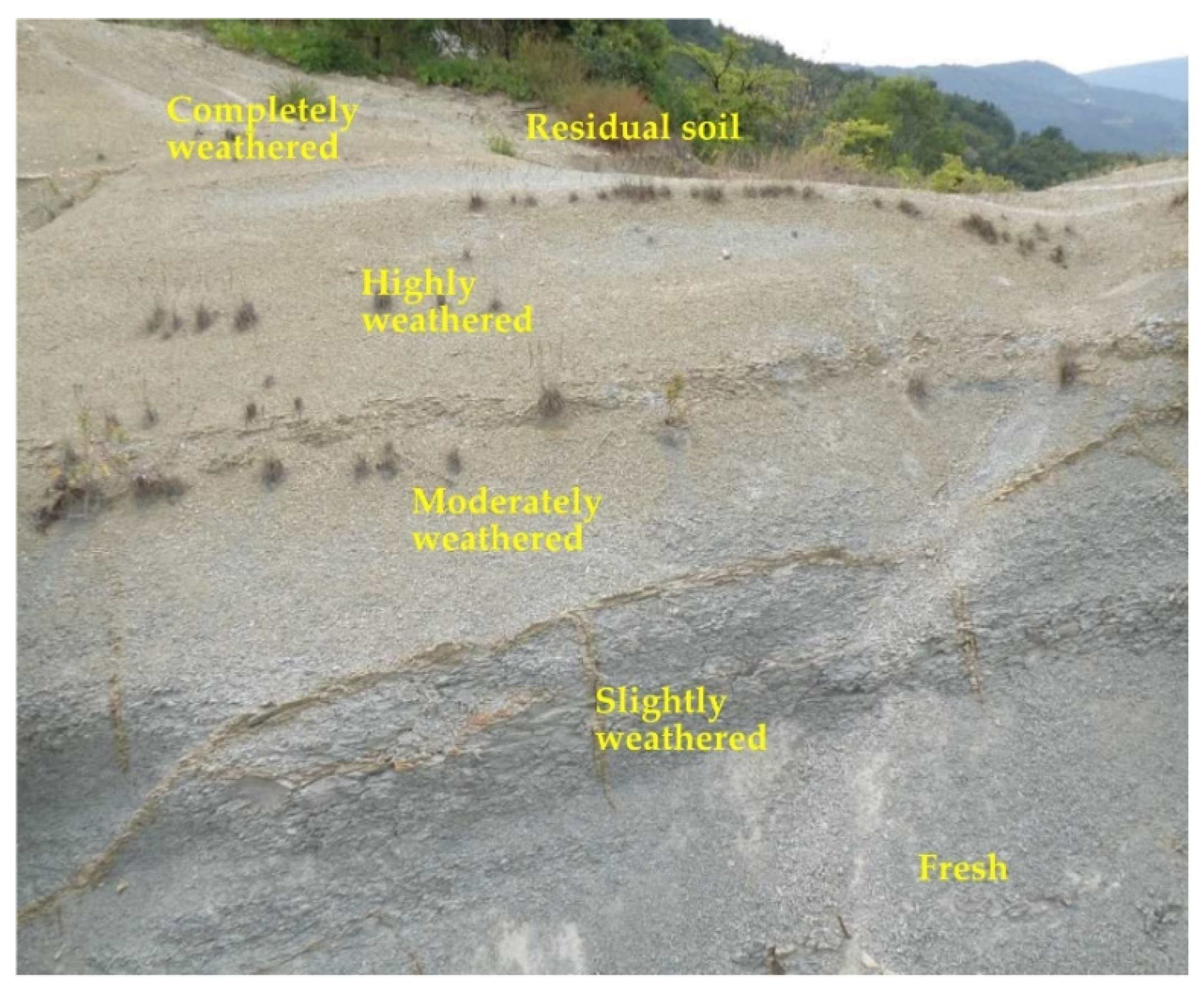
3.1. Laboratory Testing

Slope instabilities in flysch rock formations in North Istria are related to the weathering effect on the shear strength of siltstones from the flysch rock mass. Vivoda Prodan et al. [14] have carried out research to determine the geotechnical properties of siltstones of different weathering grades and their changes within the weathering process. A series of laboratory tests was performed to determine the variability of the geotechnical parameters of the siltstone samples of different weathering grades: I (FR), III (MW), and V (CW). Three samples of different weathering grades I (FR), III (MW), and V (CW) were taken from the flysch outcrop near the Krbavčići landslide in North Istria (Figure 8) and crumbled before the laboratory testing of the residual shear strength in the ring shear and direct shear devices. Disturbed and remolded up to the engineering soil grade siltstone samples match with the material condition at the sliding surface where the natural disintegration of the siltstone occurs due to stresses and strains during sliding. The strength of naturally disturbed materials and laboratory remolded samples decreased from peak to residual values due to sliding (deformation), that imply on the necessity of the residual strength of siltstones testing.
The ICL-1 ring shear device used (Marui & Co., Ltd., Osaka, Japan, 2011) (Figure 10) can maintain an undrained condition in a sample with pore water pressure up to 1 MPa and load normal stress up to 1 MPa [63,64]. Prior to testing of the prepared siltstone samples, an initial water leakage test and a friction test between the upper and lower rubber were performed. Water leakage test was performed at maximum device speed of 5.4 cm/s, total maximum normal stress of 800 kPa, and a contact stress of 1.0 kN, and no water leakage occurred. Therefore, all further testing on siltstone samples was conducted at the contact stress of 1.0 kN. The amount of friction or shearing resistance between the upper and lower pair of rubbers at a contact stress of 1.0 kN depends on the magnitude of the normal stress. For a normal stress value of 200 kPa, the friction between the upper and lower rubber is 15 kPa, for a normal stress of 400 kPa it is 17 kPa, while the friction at normal stress of 800 kPa is 33 kPa. The total shearing resistance, measured during the siltstone sample shearing, must be reduced for the value of the rubber friction to obtain the real value of the shearing resistance of a material. Siltstone samples of different weathering grades were completely saturated with de-aired distilled water prior to testing in the device. The ring shear box was filled with CO2 and de-aired distilled water, and then the disturbed, previously saturated sample was built in. After the sample saturation checking and consolidation at (σ0, τ0) = (190, 70), (280, 100), and (375, 137) kPa, shearing using pore pressure control was conducted. Pore pressure in natural slopes gradually increases due to a rise of groundwater level during rainfall and surface water infiltration. The pore pressure control tests, which simulate natural groundwater rise conditions, were carried out at a constant speed of 0.50 kPa/min. The water pressure supplied to the shear box was gradually increased and the water was allowed to drain up through a sample. The basic parameters were determined from the pore pressure control test: Peak and residual friction angle and cohesion, as well as the steady-state normal and shear stresses could be determined. Results of the ring shear tests on three samples of different weathering grades I (FR), III (MW), and V (CW) are published by Vivoda Prodan et al. [14].
Siltstone samples of different weathering grades were also tested in a standard direct shear device model 27-WF2160, Controls, in the 60 × 60 mm shear box. Siltstone slurry samples were consolidated under effective stresses of 50, 100, 200, and 400 kPa and then sheared in two cycles at a constant shear speed of 0.015 mm/min. The samples were sheared in two cycles to provide the necessary deformations to achieve the residual shear strength of materials. Direct shear tests are performed on the three samples of different weathering grades I (FR), III (MW), and V (CW), and are the test results new to this study. Direct shear test results published by Vivoda Prodan et al. [14] were performed in another device and sheared only in one cycle and, consequently, presented different results. However, newly performed tests in two cycles have shown that, after the second cycle, the samples showed a slight but regular decrease in residual shear strength with increasing weathering grades.

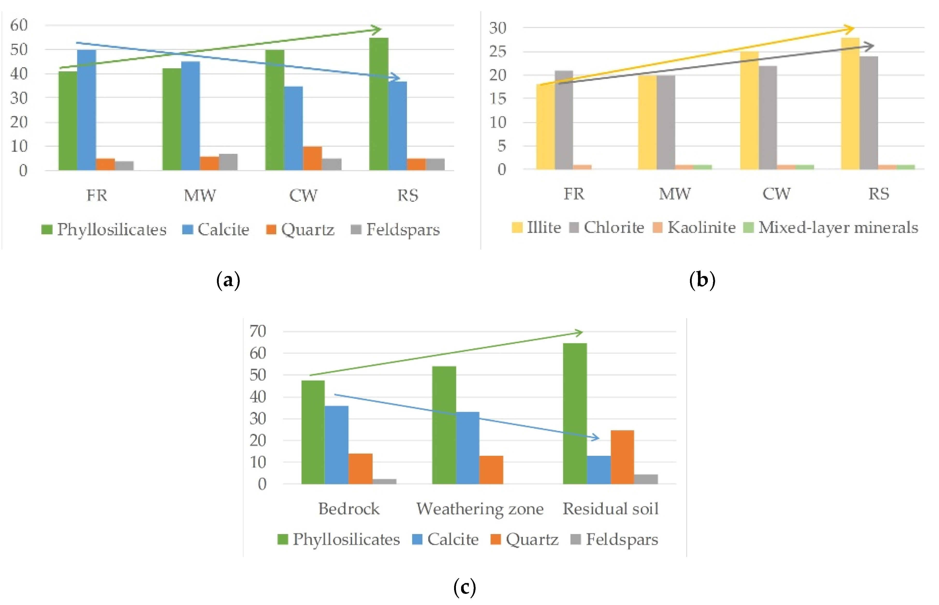
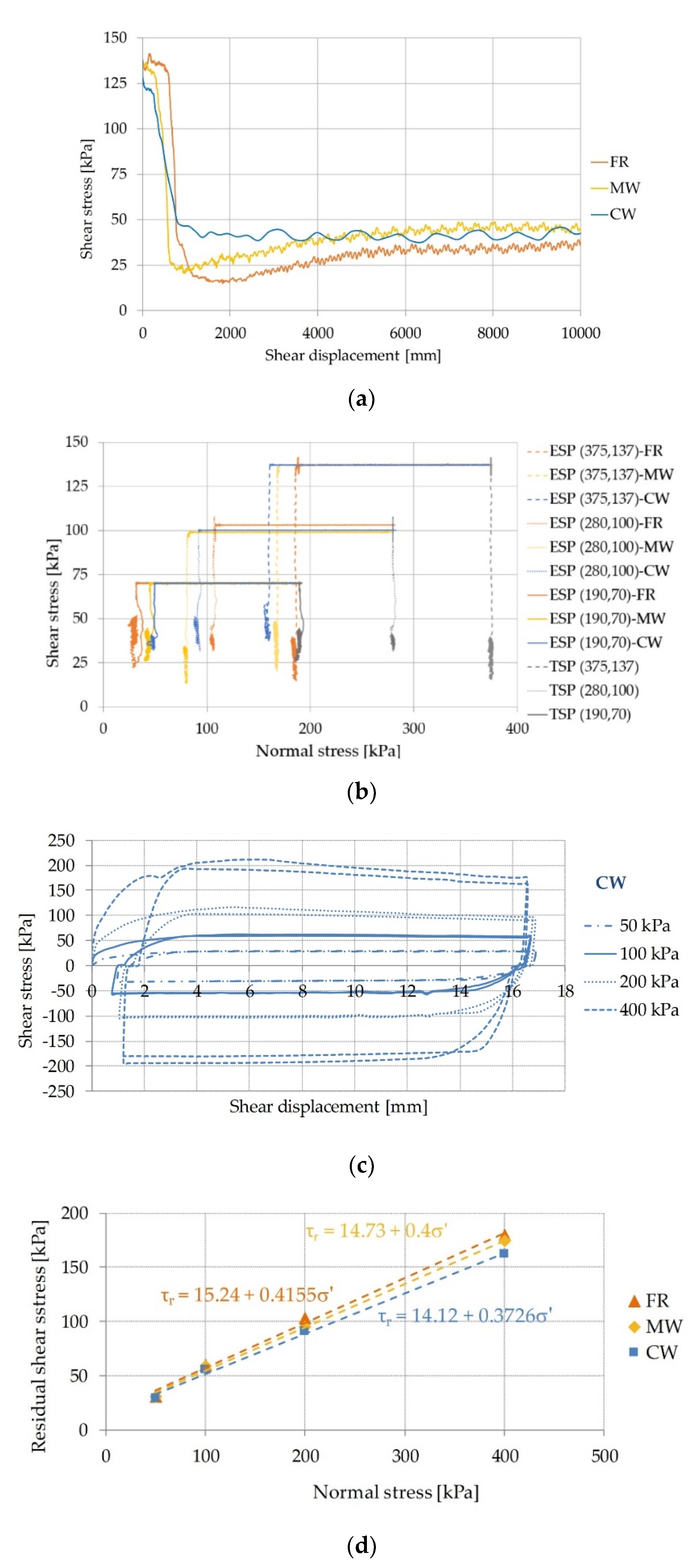
3.2. Laboratory Test Results

Peak and residual friction angle and cohesion, as well as steady-state normal and shear stress, were determined on the basis of the ring shear and direct shear laboratory tests on the siltstone samples of different weathering grades and are presented in Table 1. Shear stress–shear displacement diagrams are shown in Figure 11a,c and normal stress–shear stress diagrams are shown in Figure 11b,d, based on the ring shear and direct shear tests. The residual friction angle of siltstone samples increased from 23° in the fresh sample I (FR) to 31° in the completely weathered V (CW) sample, and residual cohesion decreased from 56 to 14 kPa, respectively. All test results indicated a decrease in the overall residual shear strength with the increase of the weathering grade of the siltstone samples: The residual friction angle increased, and the residual cohesion decreased with increasing weathering grades.
Vivoda Prodan et al. [14] found significant differences between the results of the strength parameters obtained with the direct shear and ring shear devices. The ring shear device is more precise and better suited for testing residual strength than the direct shear device due to, the following reasons: (1) The ring shear device allows large (practically unlimited) shear deformations along the shear surface compared to the direct shear device (only a few cm), which affects the final shear strength value; (2) the sample shearing in the ring shear device develops at constant shear surface, whereas the shear surface changes (decreases) during shearing in the direct shear device; and (3) the strength envelope in the direct shear device is based on three specific individual results, whereas the ring shear device allows the full strength envelope to be represented.

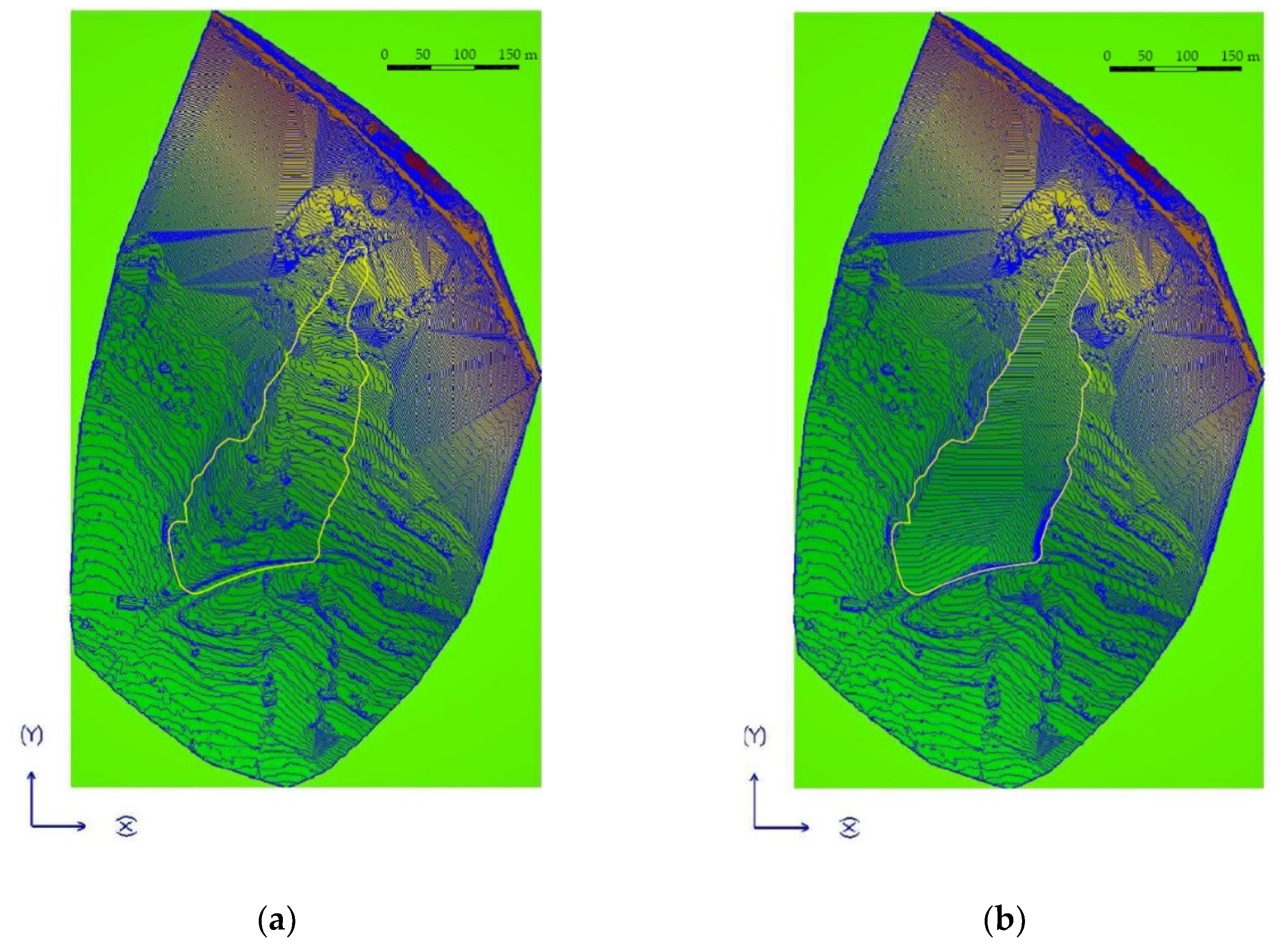
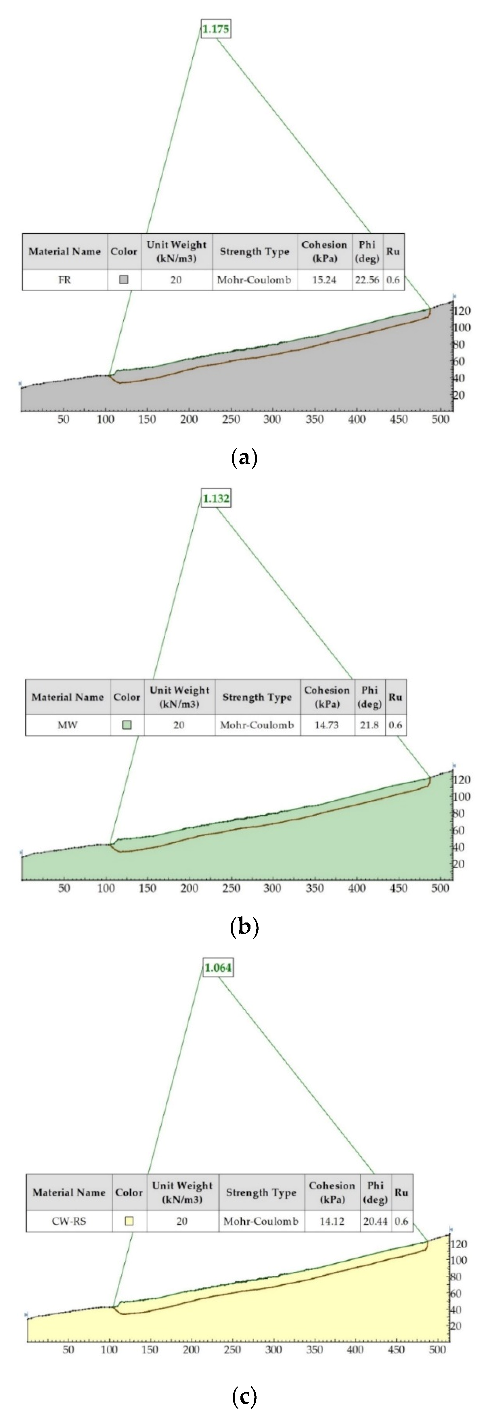
3.3. Slope Stability Analysis and Numerical Simulations of Landslide Reactivation

In order to determine possible scenarios in the slope in case of an increase of the groundwater level and further flysch rock mass weathering at the sliding surface, the slope stability analyses and numerical simulations of a possible Krbavčići landslide reactivation are performed. Two-dimensional slope stability analyses were performed employing the Rocscience Slide software, version 6,032 (Rocscience Inc., Toronto, ON, Canada), using the Bishop’s limit equilibrium method. The analyses were performed at the profile 2–2′ in the central part of the Krbavčići landslide which was recorded in 2016. The sliding surface was coopted from the field investigations carried out in 1979 (Figure 6a and Figure 7). The material below the terrain surface is assumed to be homogeneous and the saturation ratio was assumed to rise to the value of ru = 0.6 corresponding to the ground water level at the ground surface. The values of the Mohr–Coulomb parameters used in the 2D analyses were the same values of the residual strength parameters obtained by the direct shear tests (Table 1).
Three-dimensional numerical landslide simulations were performed using the LS-Rapid software (Version 2.01, Godai Kaihatsu Co., Ltd., Kanazawa, Japan, 2010). The LS-Rapid simulation software aims to integrate the initialization process (stability analysis) by pore pressure increasing and/or seismic loading and the movement process (dynamic analysis), including the process of volume increasing by entraining unstable deposits within the traveling course. The basic concept of this simulation was described by Sassa et al. [65].
The numerical model of the Krbavčići landslide covers the matrix 535 m in x-direction and 880 m in y-direction with 1.0 m distance contours (Figure 12a), based on the DEM derived in 2016 (Figure 6b). The maximum altitude of the model was 462 m a.s.l. and the lowest 260 m a.s.l. According to results of field investigations from 1979 and engineering-geological cross sections through the boreholes [57], the sliding surface elevation was determined (Figure 12b). The depth of the sliding surface ranged from 10.4 m (borehole B-11) to a maximum of 15.4 m (borehole B-15). The number of column elements within a landslide mass was 321.435.
In order to include an influence of the weathering of the siltstones from flysch rock mass on a possible reactivation of Krbavčići landslide, the numerical analyses were carried out taking shear strength for three different weathering grades of flysch rock mass at the sliding surface: I (FR), III (MW), and V (CW). The parameter values of the siltstone material used in these numerical models, which depended on the weathering grade, are presented in Table 2. These values were obtained on the basis of a combination of data values obtained by laboratory tests in direct and ring shear devices (Figure 11), average parameter values from previous studies, and indicative parameter values for cases where all the data from the field of research are not available [65]. The rise of the groundwater level was given as the main triggering factor and it was defined by the rise of saturation ratio, ru. The saturation ratio, ru, increased from 0 to a value of 0.60, after which the value remained constant. The value of the saturation ratio ru = 0 corresponded to the case without groundwater in the slope, while the value ru = 0.60 corresponded to the groundwater level at the ground surface and the saturated state in the landslide body. The default duration of an increase of the saturation ratio in the model was 3 s, which is proportional to the 30 days of the real-time period.

4. Results of the Slope Stability Analysis and Numerical Simulations of Landslide Reactivation

The conditions that could cause the reactivation of Krbavčići landslide were analyzed and discussed. Two-dimensional stability analysis was performed for fully saturated slope conditions when the ru = 0.6. The safety factors obtained in the two-dimensional stability analysis depending on the weathering grade of the siltstones from the flysch rock mass are shown in Figure 13.
The safety factor decreased with increases in siltstone weathering grade. The slope built in the siltstone material of weathering grade I (FR) indicated a safety factor of 1.175. The safety factor decreased slightly to the value 1.132 for the slope built in the siltstone material with a III (MW) weathering grade and to the value 1.064 for the slope built in the siltstone material with a V (CW) weathering grade. The safety factor for the slope built in the completely weathered siltstone material was 1.064, which is very close to the slope stability limit.
The results of 3D stability analyses using the LS-Rapid software for different weathering grades of flysch rock mass show the areas within the landslide body that will be reactivated under unfavorable hydrogeological conditions. The comparison between the initial slope surface and the results of the numerical analysis for the sliding surface in I (FR), III (MW), and V (CW) weathering grades, at ru = 0.6 is shown in Figure 14a–c respectively. The yellow line shows the border of the old landslide and the violet lines show the areas of the landslide reactivation zones. The numerical simulation is terminated when all points in the model reach a velocity equal to zero, or when the triggered sliding mass has taken a new stable position. The results of the numerical simulations show slight differences in the movement of the sliding mass with a change in the weathering grade of the siltstones from a flysch rock mass below the ground surface. The area involved in the sliding is larger for the slope built of fully weathered V (CW) siltstones relative to the slopes built of siltstones of II (MW) and I (FR) weathering grades. If we analyze the increase in areas of the landslide reactivation zones (Figure 14), it can be seen that the reactivated areas for slopes built of fully weathered V (CW) siltstones cover 12,597 m2; for slopes built of moderately weathered II (MW) siltstones, they cover 11,483 m2, and for slopes built of fresh I (FR) siltstones, they cover 9.637 m2, while the entire landslide area covers 40,936 m2. Numerical simulation results show the increase in landslide reactivated areas with an increasing of weathering grades, from 23.5%, 28.1%, to 30.8% of the entire landslide area for I (FR), II (MW), and V (CW) weathering grades, respectively.
The results of the 2D analysis agree with the results of the 3D simulation, as only a slight difference in the sliding mass distribution and slope safety factor is visible in the slope built in flysch rock mass of different weathering grades. From the analyses it can be concluded that the stability of the Krbavčići landslide decreases slightly with increases in the flysch rock mass weathering grade.

5. Discussion and Conclusions

The weathering of flysch rock masses, especially of their incompetent members such as siltstones, plays an important role in the behavior of flysch rock masses, and thus influences the processes on slopes. The aim of this article was to investigate the influence of weathering of flysch rock mass and appropriate decrease of the residual shear strength on possible landslide reactivation.
Laboratory results obtained by ring shear and direct shear tests on samples with different weathering grades taken from the flysch rock mass outcrop indicated a decrease in residual shear strength with an increase in the weathering grade. Changes in the mineralogical composition were also observed with changes in the siltstone weathering grade, leading to the significant decomposition of rock mass structure.
Shear strength parameters obtained from laboratory tests were used as input parameters to provide 2D stability analyses using the Rocscience slope stability software and deterministic 3D stability analyses using the landslide simulation software LS-Rapid. The LS-Rapid simulation software integrates the initiation of the landslide process triggered by rainfall and the development of sliding due to strength reduction and entrainment of deposits in the runout path.
The results of the 2D and deterministic 3D slope stability analyses carried out at the Krbavčići landslide case study match quite well and show the critical areas for a possible reactivation of a landslide under unfavorable hydrogeological conditions. From the results of numerical 2D stability analyses and 3D simulations carried out for the Krbavčići landslide it is clearly identified that the rise of the ground water level to the surface will not cause any significant movements of the landslide body, regardless of the flysch rock mass weathering on the slope. However, with a weathering of material at the sliding surface to the completely weathered rock mass V (CW), the safety factor will fall down and will be slightly higher than 1.0 (1.064), which, given the accuracy of the model and the reliability of the geotechnical analyses, indicates that the landslide can reach the state of possible reactivation.
The Krbavčići landslide activated in North Istria in 1979 is currently dormant and has not been moving for the last 40 years. A large number of landslides on the flysch slopes have been reactivated by extreme weather events, such as the Grohovo landslide reactivated in 1996 [32,66], the Valići landslide reactivated in 2014 [33,34] in Rječina Valley, the Krbavčići debris flow in North Istria reactivated in 2003 [2] in Croatia, the Ca’ Lita landslide reactivated in period from 2002 to 2004 in Italy [67], and numerous landslides reactivated in Slovenia in 2010 [68]. A reactivation of the Krbavčići landslide is possible under the conditions of long-lasting precipitation events and the resulting rise in the groundwater level or in the case of landslides where a further weathering of rock mass has developed along existing sliding surfaces. The weathering process on the sliding surface is greater than on the ground surface and a decrease in the shear strength can be expected.
Prolonged rainfall events are critical for landslide initiation, while short and intensive rainfall events play a greater role in erosion processes. An increase in the total precipitation is expected to result in wetter antecedent conditions, which can have multiple negative consequences on slope instability, including (i) less rain required to reach a critical level that could cause a slope to fail, and (ii) higher water table contributing to the reduction of shear strength, to the reduction in soil suction and cohesion, and to an increase in the weight (wet density) of the slope materials, all working to enhance the slope instability [69]. The three month cumulative rainfall amount which triggered the Krbavčići landslide at the end of January 1979 was 479.1 mm. There were 33 such events recorded from 1961 to 2017, 10 of them occurred before 1979 (in 1964, 1966, 1967, 1970, 1976, and 1977) and 23 of them after Krbavčići landslide event (in 1979, 1980, 1992, 1993, 1997, 1998, 2000, 2001, 2009, 2010, and 2012). Under the circumstances of global climate change with changes in rainfall patterns, with longer summer dry periods and rainy winters in research area, a rise in the three-month cumulative rainfall amounts is expected in the future. In combination with the described influence of rock mass weathering on shear strength along the slip surface, these circumstances would lead to the Krbavčići landslide reactivation.
The use of SfM techniques enables the application of UAV flights to obtain DTMs from which vertical and horizontal displacements and volumetric slope changes can be calculated. Further research will use new DTMs determined by UAV flights, which will provide insight into the Krbavčići landslide’s possible movements and signs of a possible reactivation. In addition, laboratory tests of flysch rock mass samples from the landslide body will be carried out and the parameters obtained will be used in further stability analyses.

Author Contributions

Conceptualization, Ž.A. and M.V.P.; methodology, Ž.A. and M.V.P.; software, M.V.P.; validation, Ž.A. and M.V.P.; formal analysis, M.V.P.; investigation, Ž.A. and M.V.P.; writing—original draft preparation, Ž.A. and M.V.P.; writing—review and editing, Ž.A. and M.V.P.; visualization, Ž.A. and M.V.P.; supervision, Ž.A. All authors have read and agreed to the published version of the manuscript.

Funding

This research received no external funding.

Acknowledgments

Part of the equipment used in the study was obtained with financial support from the SATREPS (Science and Technology Research Partnership for Sustainable Development) program, financed by the Japan Science and Technology Agency and Japan International Cooperation Agency through the Project Risk Identification and Land-Use Planning for Disaster Mitigation of Landslides and Floods in Croatia. In addition, this work has been supported in part by the Ministry of Science, Education and Sports of the Republic of Croatia under the project Research Infrastructure for Campus-based Laboratories at the University of Rijeka, number RC.2.2.06-0001. Project has been co-funded from the European Fund for Regional Development (ERDF). This support is gratefully acknowledged. The authors are also grateful to Branko Kordić who performed airborne laser scanning and provided DTM of the Krbavčići landslide in 2016. Rainfall data received from Croatian Meteorological and Hydrological Service are also gratefully acknowledged.

Conflicts of Interest

The authors declare no conflict of interest. The funders had no role in the design of the study; in the collection, analyses, or interpretation of data; in the writing of the manuscript; or in the decision to publish the results.

References

  1. Velić, I.; Vlahović, I. Geologic Map of Republic of Croatia 1:300.000; Croatian Geological Survey: Zagreb, Croatian, 2009. [Google Scholar]
  2. Dugonjić Jovančević, S.; Arbanas, Ž. Recent landslides on the Istrian Peninsula, Croatia. Nat. Hazards 2012, 62, 1323–1338. [Google Scholar] [CrossRef]
  3. Mihljević, D.; Prelogović, E. Structural—Geomorphological characteristic of the mountain ranges Učka & Ćićarija. In Proceedings of the International Symposium Geomorphology and Sea, Meeting of the Geomorphological Commission of the Carpatho-Balkan Countries, Mali Lošinj, Croatia, 22–26 September 1992; pp. 13–24. [Google Scholar]
  4. Arbanas, Z.; Dugonjic, S.; Benac, C. Causes of small scale landslides in flysch deposits of Istria, Croatia. In Landslide Science and Practice: Landslide Inventory and Susceptibility and Hazard Zoning; Margottini, C., Canuti, P., Sassa, K., Eds.; Springer: Rome, Italy, 2013; Volume 1, pp. 221–226. ISBN 9783642313240. [Google Scholar]
  5. Arbanas, Ž.; Mihalić Arbanas, S.; Dugonjić Jovančević, S.; Vivoda, M. Brus landslide, translational block sliding in flysch rock mass. In Proceedings of the European Rock Mechanics Symposium (Eurock 2010), Laussane, Switzerland, 15–18 June 2010; pp. 635–638. [Google Scholar]
  6. Arbanas, Ž.; Benac, Č.; Jurak, V. Causes of debris flow formation in flysch area of North Istria, Croatia. In Monitoring, Simulation, Prevention and Remediation of Dense and Debris Flows; Lorenzini, G., Brebbia, C.A., Emmanouloudis, D., Eds.; WIT Transaction on Ecology and the Environment: Southampton, UK, 2006; Volume 90, pp. 283–292. [Google Scholar]
  7. Žufić, E. Investigation of Geotehnical Properties of Flysch Rock Mass in Istria Area. Master’s Thesis, University of Zagreb, Zagreb, Croatia, 2011. [Google Scholar]
  8. Gulam, V. The Erosion of Flysch Badlands in the Central Istria. Ph.D. Thesis, University of Zagreb, Zagreb, Croatia, 2012. [Google Scholar]
  9. Chandler, R.J. The effects of weathering on the shear strength properties of Keupler marl. Geotehnique 1969, 19, 321–334. [Google Scholar] [CrossRef]
  10. Reiβmüller, M. Geotechnische Eigenschaften Verwitterter Kfssener Mergel. Ph.D. Thesis, Technical University of Munich, Munich, Germany, 1997. [Google Scholar]
  11. Bhattarai, P.; Marui, H.; Tiwari, B.; Watanabe, N.; Tuladhar, G.; Aoyama, K. Influence of Weathering on Physical and Mechanical Properties of Mudstone. In Disaster Mitigation of Debris Flows, Slope Failures and Landslides; Universal Academy Press, Inc.: Tokyo, Japan, 2006; pp. 467–479. [Google Scholar]
  12. Vivoda Prodan, M.; Arbanas, Ž. Weathering Influence on Properties of Siltstones from Istria, Croatia. Adv. Mater. Sci. Eng. 2016, 2016. [Google Scholar] [CrossRef] [Green Version]
  13. Vivoda Prodan, M. The Influence of Weathering Process on Residual Shear Strength of Fine Grained Lithological Flysch Components. Ph.D. Thesis, University of Rijeka, Rijeka, Croatia, 2016. [Google Scholar]
  14. Vivoda Prodan, M.; Mileusnić, M.; Mihalić Arbanas, S.; Arbanas, Ž. Influence of weathering processes on the shear strength of siltstones from a flysch rock mass along the North Croatian Adriatic Coast. Bull. Eng. Geol. Environ. 2017, 76, 695–711. [Google Scholar] [CrossRef]
  15. Maček, M.; Petkovšek, A.; Arbanas, Ž.; Mikoš, M. Geotechnical aspects of landslides in flysch in Slovenian and Croatian. In Proceedings of the 2nd ReSyLAB—Regional Symposium on Landslides in the Adriatic-Balkan Region, Belgrade, Serbia, 14–16 May 2015; pp. 25–30. [Google Scholar]
  16. Peranić, J. Importance of Geotechnical Cross-Section Unsaturated Zone for Landslide Occurrence in Flysch Deposits. Ph.D. Thesis, University of Rijeka, Rijeka, Croatia, 2019. [Google Scholar]
  17. Peranić, J.; Arbanas, Ž.; Cuomo, S.; Maček, M. Soil-water characteristic curve of residual soil from a flysch rock mass. Geofluids 2018. [Google Scholar] [CrossRef]
  18. Peranić, J.; Arbanas, Ž. Impact of the wetting process on the hydro-mechanical behavior of unsaturated residual soil from flysch rock mass: Preliminary results. Bull. Eng. Geol. Environ. 2020, 79, 985–998. [Google Scholar] [CrossRef]
  19. Peranić, J.; Moscariello, M.; Cuomo, S.; Arbanas, Ž. Hydro-mechanical properties of unsaturated residual soil from a flysch rock mass. Eng. Geol. 2020, 269, 105546. [Google Scholar] [CrossRef]
  20. Dugonjić Jovančević, S.; Rubinić, J.; Arbanas, Ž. Conditions and triggers of landslides on flysch slopes in Istria, Croatia. Eng. Rev. 2020, 40, 77–87. [Google Scholar]
  21. Dugonjić Jovančević, S.; Arbanas, Ž. Influence of the runout potential on landslide-susceptible areas along the flysch–karst contact in Istria, Croatia. Nat. Hazards 2017, 85, 1347–1362. [Google Scholar] [CrossRef]
  22. Eberhardt, E.; Thuro, K.; Luginbuehl, M. Slope instability mechanisms in dipping interbedded conglomerates and weathered marls—The 1999 Rufi landslide, Switzerland. Eng. Geol. 2005, 77, 35–56. [Google Scholar] [CrossRef]
  23. Miščević, P.; Števanić, D.; Štambuk-Cvitanović, N. Slope instability mechanisms in dipping conglomerates over weathered marls: Bol landslide, Croatia. Environ. Geol. 2009, 56, 1417–1426. [Google Scholar] [CrossRef]
  24. Zhang, L.L.; Fredlund, D.G.; Fredlund, M.D.; Wilson, G.W. Modeling the unsaturated soil zone in slope stability analysis. Can. Geotech. J. 2014, 51, 1384–1398. [Google Scholar] [CrossRef]
  25. Berti, M.; Bertello, L.; Bernardi, A.R.; Caputo, G. Back analysis of a large landslide in a flysch rock mass. Landslides 2017, 14, 2041–2058. [Google Scholar] [CrossRef]
  26. Kogut, J.P.; Pilecka, E.; Szwarkowski, D. Analysis of landslide effects along a road located in the Carpathian flysch. Open Geosci. 2018, 10, 517–531. [Google Scholar] [CrossRef]
  27. Santo, A.; Di Crescenzo, G.; Forte, G.; Papa, R.; Pirone, M.; Urciuoli, G. Flow-type landslides in pyroclastic soils on flysch bedrock in southern Italy: The Bosco de’ Preti case study. Landslides 2018, 15, 63–82. [Google Scholar] [CrossRef]
  28. Anagnostopoulou, S.; Boumpoulis, V.; Lampropoulou, P.; Servou, A.; Depountis, N.; Sabatakakis, N. The Behavior of the Highly Weathered and Partially Decomposed Flysch in the Reactivation of Landslide Phenomena in Greece BT. In Proceedings of the IAEG/AEG Annual Meeting Proceedings, San Francisco, CA, USA, 17–21 September 2018; pp. 119–124. [Google Scholar]
  29. Zabuski, L. Three-Dimensional Analysis of a Landslide Process on a Slope in Carpathian Flysch. Arch. Hydro Eng. Environ. Mech. 2019, 66, 27–45. [Google Scholar] [CrossRef] [Green Version]
  30. Miščević, P.; Vlastelica, G. Time-dependent stability of slopes excavated in marl. Građevinar 2012, 64, 451–461. [Google Scholar]
  31. Dugonjić Jovančević, S.; Nagai, O.; Sassa, K.; Arbanas, Ž. Deterministic landslide susceptibility analyses using LS-Rapid software. In Proceedings of the 1st Regional Symposium on Landslides in the Adriatic-Balkan Region “Landslide and Flood Hazard Assessment”, Zagreb, Croatia, 6–9 March 2013; pp. 73–77. [Google Scholar]
  32. Vivoda, M.; Dugonjić Jovančević, S.; Arbanas, Ž. Landslide Occurrence Prediction in the Rječina River Valley as a Base for an Early Warning System. In Proceedings of the 1st Regional Symposium on Landslides in the Adriatic-Balkan Region “Landslide and Flood Hazard Assessment”, Zagreb, Croatia, 6–9 March 2013; pp. 85–90. [Google Scholar]
  33. Arbanas, Ž.; Mihalić Arbanas, S.; Vivoda Prodan, M.; Peranić, J.; Sečanj, M.; Bernat Gazibara, S.; Krkač, M. Preliminary Investigations and Numerical Simulations of a Landslide Reactivation BT—Advancing Culture of Living with Landslides; Mikoš, M., Tiwari, B., Yin, Y., Sassa, K., Eds.; Springer International Publishing: Cham, Germany, 2017; pp. 649–657. [Google Scholar]
  34. Vivoda Prodan, M.; Arbanas, Ž. Parametric Analysis of Weathering Effect on Possible Reactivation of the Valići Landslide, Croatia BT—Advancing Culture of Living with Landslides; Mikoš, M., Tiwari, B., Yin, Y., Sassa, K., Eds.; Springer International Publishing: Cham, Germany, 2017; pp. 621–631. [Google Scholar]
  35. Peranić, J.; Jagodnik, V.; Arbanas, Ž. Rainfall infiltration and stability analysis of an unsaturated slope in residual soil from flysch rock mass. In Proceedings of the XVII ECSMGE-2019 “Geotechnical Engineering Foundation of the Future”, Reykjavik, Iceland, 1–6 September 2019; pp. 1–8. [Google Scholar]
  36. Collins, B.D.; Dobroslav, Z. Stability Analyses of Rainfall Induced Landslides. J. Geotech. Geoenviron. Eng. 2004, 130, 362–372. [Google Scholar] [CrossRef]
  37. Springman, S.M.; Thielen, A.; Kienzler, P.; Friedel, S. A long-term field study for the investigation of rainfall-induced landslides. Géotechnique 2013, 63, 1177–1193. [Google Scholar] [CrossRef]
  38. Giordan, D.; Hayakawa, Y.; Nex, F.; Remondino, F.; Tarolli, P. Review article: The use of remotely piloted aircraft systems (RPASs) for natural hazards monitoring and management. Nat. Hazards Earth Syst. Sci. 2018, 18, 1079–1096. [Google Scholar] [CrossRef] [Green Version]
  39. Westoby, M.J.; Brasington, J.; Glasser, N.F.; Hambrey, M.J.; Reynolds, J.M. ‘Structure-from-Motion’ photogrammetry: A low-cost, effective tool for geoscience applications. Geomorphology 2012, 179, 300–314. [Google Scholar] [CrossRef] [Green Version]
  40. Chao, H.; Cao, Y.; Chen, Y. Autopilots for small unmanned aerial vehicles: A survey. Int. J. Control. Autom. Syst. 2010, 8, 36–44. [Google Scholar] [CrossRef]
  41. Kaiser, A.; Neugirg, F.; Rock, G.; Müller, C.; Haas, F.; Ries, J.; Schmidt, J. Small-Scale Surface Reconstruction and Volume Calculation of Soil Erosion in Complex Moroccan Gully Morphology Using Structure from Motion. Remote Sens. 2014, 6, 7050–7080. [Google Scholar] [CrossRef] [Green Version]
  42. Dugonjić Jovančević, S.; Peranić, J.; Ružić, I.; Arbanas, Ž. Analysis of a historical landslide in the Rječina River Valley, Croatia. Geoenviron. Dis. 2016, 3, 26. [Google Scholar] [CrossRef] [Green Version]
  43. Fernández, T.; Pérez, J.L.; Cardenal, J.; Gómez, J.M.; Colomo, C.; Delgado, J. Analysis of Landslide Evolution Affecting Olive Groves Using UAV and Photogrammetric Techniques. Remote Sens. 2016, 8, 837. [Google Scholar] [CrossRef] [Green Version]
  44. Chudý, F.; Slámová, M.; Tomaštík, J.; Prokešová, R.; Mokroš, M. Identification of Micro-Scale Landforms of Landslides Using Precise Digital Elevation Models. Geosciences 2019, 9, 117. [Google Scholar] [CrossRef] [Green Version]
  45. Godone, D.; Allasia, P.; Borrelli, L.; Gullà, G. UAV and Structure from Motion Approach to Monitor the Maierato Landslide Evolution. Remote Sens. 2020, 12, 1039. [Google Scholar] [CrossRef] [Green Version]
  46. Frodella, W.; Elashvili, M.; Spizzichino, D.; Gigli, G.; Adikashvili, L.; Vacheishvili, N.; Kirkitadze, G.; Nadaraia, A.; Margottini, C.; Casagli, N. Combining InfraRed Thermography and UAV Digital Photogrammetry for the Protection and Conservation of Rupestrian Cultural Heritage Sites in Georgia: A Methodological Application. Remote Sens. 2020, 12, 892. [Google Scholar] [CrossRef] [Green Version]
  47. Hapke, C.; Richmond, B. Monitoring beach morphology changes using small-format aerial photography and digital softcopy photogrammetry. Environ. Geosci. 2000, 7, 32–37. [Google Scholar] [CrossRef]
  48. Mancini, F.; Dubbini, M.; Gattelli, M.; Stecchi, F.; Fabbri, S.; Gabbianelli, G. Using Unmanned Aerial Vehicles (UAV) for High-Resolution Reconstruction of Topography: The Structure from Motion Approach on Coastal Environments. Remote Sens. 2013, 5, 6880–6898. [Google Scholar] [CrossRef] [Green Version]
  49. Ružić, I.; Marović, I.; Vivoda, M.; Dugonjić Jovančević, S.; Kalajžić, D.; Benac, Č.; Ožanić, N. Application of Structure-from-Motion photogrammetry for erosion processes monitoring, Mosčenička Draga example. In Proceedings of the 4th Workshop of the Japanese-Croatian Project on “Risk Identification and Land-Use Planning for Disaster Mitigation of Landslides and Floods in Croatia”, Split, Croatia, 12–14 December 2013; pp. 49–50. [Google Scholar]
  50. Pikelj, K.; Ružić, I.; Ilić, S.; James, M.R.; Kordić, B. Implementing an efficient beach erosion monitoring system for coastal management in Croatia. Ocean. Coast. Manag. 2018, 156, 223–238. [Google Scholar] [CrossRef] [Green Version]
  51. Laporte-Fauret, Q.; Marieu, V.; Castelle, B.; Michalet, R.; Bujan, S.; Rosebery, D. Low-Cost UAV for High-Resolution and Large-Scale Coastal Dune Change Monitoring Using Photogrammetry. J. Mar. Sci. Eng. 2019, 7, 63. [Google Scholar] [CrossRef] [Green Version]
  52. Kerle, N.; Nex, F.; Gerke, M.; Duarte, D.; Vetrivel, A. UAV-Based Structural Damage Mapping: A Review. ISPRS Int. J. Geo-Inf. 2020, 9, 14. [Google Scholar] [CrossRef] [Green Version]
  53. Pepe, M.; Costantino, D.; Crocetto, N.; Restuccia Garofalo, A. 3D modeling of roman bridge by the integration of terrestrial and uav photogrammetric survey for structural analysis purpose. ISPRS Int. Arch. Photogramm. Remote Sens. Spat. Inf. Sci. 2019, XLII-2/W17, 249–255. [Google Scholar] [CrossRef] [Green Version]
  54. Tkac, M.; Mesaros, P.; Behun, M.; Mandicak, T. Aerial Photogrammetry and Unmanned Aerial Vehicles (UAVs) Like a Smart Technology for Digital As-Built Mapping of Existing Buildings BT. In Proceedings of the 4th EAI International Conference on Management of Manufacturing Systems; Knapcikova, L., Balog, M., Perakovic, D., Perisa, M., Eds.; Springer International Publishing: Cham, Germany, 2020; pp. 43–51. [Google Scholar]
  55. Kordić, B.; Pribičević, B.; Đapo, A.; Babić, L.; Govorčin, M. Application of UAS for Spatial Data Acquisition. In Proceedings of the International Symposium on Engineering Geodesy, Varaždin, Croatia, 20–22 May 2016; pp. 539–546. [Google Scholar]
  56. Hassler, S.C.; Baysal-Gurel, F. Unmanned Aircraft System (UAS) Technology and Applications in Agriculture. Agronomy 2019, 9, 618. [Google Scholar] [CrossRef] [Green Version]
  57. Engineering-Geological Report, Landslides Krbavčići I and Krbavčići II near the City of Buzet. Rijekaprojekt: Rijeka, Croatia, 1979.
  58. Inventory. (WP/WLI) International Geotechnical Society’s UNESCO Working Party on World Landslide a Multi-Lingual Landslide Glossary; Bitech Publishers: Vancouver, BC, Canada, 1993. [Google Scholar]
  59. Skempton, A.W.; Hutchinson, J.N. Stability of natural slopes and embankment foundations. In Proceedings of the 7th International Conference on Soil Mechanics and Foundation Engineering, Mexico City, Mexico, 22–31 August 1969; pp. 291–340. [Google Scholar]
  60. Hungr, O.; Leroueil, S.; Picarelli, L. The Varnes classification of landslide types, an update. Landslides 2014, 11, 167–194. [Google Scholar] [CrossRef]
  61. Cruden, D.M.; Varnes, D.J. Landslide Type and Processes. Landslides: Investigation and Mitigation. In Special Report 247; Turner, A.K., Schuster, R.L., Eds.; Transportation Research Board, National Research Council: Washington, DC, USA, 1996; pp. 36–75. [Google Scholar]
  62. Brown, E.T. Rock Characterization, Testing & Monitoring: ISRM Suggested Methods; Commission on Testing Methods; International Society for Rock Mechanics; Pergamon Press: Oxford, UK, 1981; ISBN 9780080273099. [Google Scholar]
  63. Sassa, K.; Fukuoka, H.; Wang, G.; Ishikawa, N. Undrained dynamic-loading ring-shear apparatus and its application to landslide dynamics. Landslides 2004, 1, 7–19. [Google Scholar] [CrossRef]
  64. Oštrić, M.; Sassa, K.; Ljutić, K.; Vivoda, M.; He, B.; Takara, K. Manual of transportable ring shear apparatus, ICL-1. In Proceedings of the 1st Regional Symposium on Landslides in the Adriatic-Balkan Region “Landslide and Flood Hazard Assessment”, Zagreb, Croatia, 6–9 March 2013; pp. 1–4. [Google Scholar]
  65. Sassa, K.; Nagai, O.; Solidum, R.; Yamazaki, Y.; Ohta, H. An integrated model simulating the initiation and motion of earthquake and rain induced rapid landslides and its application to the 2006 Leyte landslide. Landslides 2010, 7, 219–236. [Google Scholar] [CrossRef]
  66. Vivoda, M.; Benac, Č.; Žic, E.; Đomlija, P.; Dugonjić Jovančević, S. Geohazards in the Rječina valley in the past and present. Croat. Waters J. Water Econ. 2012, 20, 105–116. [Google Scholar]
  67. Borgatti, L.; Corsini, A.; Barbieri, M.; Sartini, G.; Truffelli, G.; Caputo, G.; Puglisi, C. Large reactivated landslides in weak rock masses: A case study from the Northern Apennines (Italy). Landslides 2006, 3, 115. [Google Scholar] [CrossRef]
  68. Petkovšek, A.; Fazarinc, R.; Kočevar, M.; Maček, M.; Majes, B.; Mikoš, M. The Stogovce landslide in SW Slovenia triggered during the September 2010 extreme rainfall event. Landslides 2011, 8, 499–506. [Google Scholar] [CrossRef]
  69. Tacher, L.; Bonnard, C. Hydromechanical modelling of a large landslide considering climate change conditions. Landslides Clim. Chang. Chall. Solut. 2007, 131–141. [Google Scholar]
Figure 1. Geological map of the North Istria peninsula (modified according to [1]) with location of the Krbavčići landslide and some of recent landslides (updated according to [2]).
Geosciences 10 00294 g001
Figure 2. Vertical alternation of sandstones and siltstones in the flysch rock mass at the road cut near the Krbavčići landslide (photo: Vivoda Prodan).
Geosciences 10 00294 g002
Figure 3. View at the flysch pillars at the Brus landslide in: (a) August 2005; (b) January 2013.
Geosciences 10 00294 g003
Figure 4. (a) Aerial view of the flysch and limestone rock masses contact in North Istria with marked area of Krbavčići landslide (photo: Medica); (b) the damaged retaining wall at the foot of the landslide in 1979 (photo: Benac); (c) the rest of the retaining wall in 2020 (photo: Vivoda Prodan).
Geosciences 10 00294 g004
Figure 5. Monthly rainfall of the 1978 and 1979 years (histograms) and mean rainfall for the period 1961–2017 (solid line) recorded at Abrami rain gauge.
Geosciences 10 00294 g005
Figure 6. The Krbavčići landslide: (a) Engineering geological map from 1979 [57]; (b) Orthophoto map from 2016 derived from aerial SfM photogrammetry, with highlighted position of boreholes, engineering geological profile, and a landslide border.
Geosciences 10 00294 g006aGeosciences 10 00294 g006b
Figure 7. Engineering geological cross section 2–2′ of the Krbavčići landslide (modified according to [57]).
Geosciences 10 00294 g007
Figure 8. Weathering profile for the flysch rock mass in the study area, near the Krbavčići landslide (according to Brown [62]) [12,13].
Geosciences 10 00294 g008
Figure 9. (a) Mineralogical content; (b) content of different clay minerals in siltstone samples with different weathering grades from the Istrian peninsula [14]; (c) mineralogical content of flysch samples from the Krbavčići landslide in Northern Istria [6]. The arrows indicate an increase in phyllosilicates content (a,c) and illite and chlorite content (b), and a decrease in calcite content (a,c), with increasing weathering grades.
Geosciences 10 00294 g009
Figure 10. The ICL-1 ring shear device (Marui & Co., Ltd., Osaka, Japan, 2011) (a) Schematic view of the device mechanical structure [64]; (b) upper part of the instrument box; (c) siltstone sample in the shear box after testing [17] (S = Specimen, CR = Connection Ring, C = Connection, SM = Shear Motor, N = Load cell for Normal Stress; S1, S2 = Load cell for shear resistance; P = Pore pressure transducer; GS = Gap sensor; VD = Vertical Displacement; SD = Shear Displacement).
Geosciences 10 00294 g010
Figure 11. Ring shear test results: (a) Shear stress–shear displacement diagram and (b) effective and total stress paths [13,14]; Direct shear test results: (c) shear stress–shear displacement diagram for completely weathered sample V (CW) and (d) normal stress–residual shear stress diagram, for flysch samples with different weathering grades from North Istria. (ESP = Effective Stress Path, TSP = Total Stress Path).
Geosciences 10 00294 g011
Figure 12. 2D digital terrain model of the Krbavčići landslide (a) slope surface; (b) sliding surface, with 1.0 m contour distance and border of the old landslide (yellow line) in the LS-Rapid simulation software (Version 2.01, Godai Kaihatsu Co., Ltd., Kanazawa, Japan, 2010).
Geosciences 10 00294 g012
Figure 13. 2D analysis results of the Krbavčići landslide at ru = 0.6 in siltstones of: (a) I (FR); (b) III (MW); (c) V (CW) weathering grades.
Geosciences 10 00294 g013
Figure 14. 3D numerical simulation results of the Krbavčići landslide at ru = 0.6 in siltstones of: (a) I (FR); (b) III (MW); (c) V (CW) weathering grades.
Geosciences 10 00294 g014aGeosciences 10 00294 g014b
Table 1. Ring shear [14] and direct shear test results on the siltstone samples from flysch rock mass with different weathering grades from North Istria.
TermSymbolDirect Shear TestRing Shear Test
ϕr (°)cr (kPa)ϕr (°)cr (kPa)τss (kPa)
FreshFR22.5615.24235638
Moderately weatheredMW21.814.73275144
Completely weatheredCW20.4414.12314242
Table 2. Values of siltstone parameters used in LS-Rapid numerical model for different weathering grades.
ParameterParameter Values Depending on the Weathering Grade of Siltstones from Flysch Rock Mass
I (FR)III (MW)V (CW)
Friction angle during motion at sliding surface (tan ϕm) 20.420.400.37
Peak friction angle at sliding surface (tan ϕp) 30.50.450.42
Friction angle inside landslide mass (tan ϕi) 30.450.420.39
Steady state shear resistance at sliding surface (τss) 138 kPa44 kPa42 kPa
Cohesion at sliding surface during motion (cp) 215.24 kPa14.73 kPa14.12 kPa
Peak cohesion at sliding surface (cm) 215.24 kPa14.73 kPa14.12 kPa
Cohesion inside mass (ci) 40 kPa0 kPa0 kPa
Total unit weight of the mass (γt) 320 kN/m3
Lateral pressure ratio (k = σhv) 30.7
Shear displacement at the start of strength reduction (DL) 15 mm
Shear displacement at the end of strength reduction (DU) 1200 mm
Pore pressure generation rate (Bss) 40.5
1 Values determined in ring shear tests, 2 Values determined in direct shear tests, 3 Average parameter values from previous investigations on similar flysch locations, 4 Indicative recommended parameter values when all the data in the study area is not available [65].

