Article

The Rock Garden of the Institute of Geography and Environmental Sciences, Jan Kochanowski University—A New Geo-Site in Kielce, Central Poland

by
Maria Górska-Zabielska
Institute of Geography and Environmental Sciences, Jan Kochanowski University, Uniwersytecka 7 St., 25-406 Kielce, Poland
Geosciences 2021, 11(3), 113; https://doi.org/10.3390/geosciences11030113
Submission received: 29 December 2020 / Revised: 2 February 2021 / Accepted: 16 February 2021 / Published: 2 March 2021

Abstract

:
The Rock Garden, established in 2019, is a geological showcase of both the Institute of Geography and Environmental Sciences of Jan Kochanowski University in Kielce and the entire Kielce region in central Poland. The collection includes specimens of about 50 rocks: those whose outcrops are located in the Holy Cross Mountains region and those brought here from Scandinavia by the ice sheet around 180 to 130 thousand years ago. The Rock Garden is of scientific importance and plays a didactic, conservational, educational, cultural, aesthetic, recreational, and geotouristic role. This article highlights its importance in the development of urban geotourism.

1. Introduction

All recorded large erratic boulders in Poland are protected by law [1] as monuments of an inanimate nature. Therefore, the largest boulder (860 m3) in Poland—a gneiss boulder with the local name of Trygław, located in Tychowo, Central Pomerania (53°55′53.5″ N and 16°15′38.7″ E)—is of conservation significance. It is only slightly smaller than the currently largest-known Scandinavian erratic boulder (930 m3), which is located in the area of glacial deposition on the north coast of Estonia, in Lahemaa National Park, and named Ehalkivi (59°32′59.2″ N and 26°35′15.6″ E). Also under protection in Poland is the largest boulder of sedimentary origin (235 m3)—Głaz Mszczonowski (Mszczonów Boulder; 51°54′51.3″ N and 20°27′15.9″ E)—which is from the Miocene age and consists of sandstone cemented by silica. It is located in the municipality of Kowiesy in central Poland. It is not of Scandinavian origin, but was transported from the area of Miocene outcrops, across which the Scandinavian ice sheet advanced during the Odranian Middle-Polish Glaciation (MIS 6 = marine isotope stage) [2]. Two of the various other boulders under protection are the largest boulder found near Gołuchów in Wielkopolska, called the boulder of St. Jadwiga (126 m3; 51°49′31.3″ N 17°56′48.6″ E) [3], and the Czarci Kamień boulder (51°19′42.0″ N and 20°25′27.2″ E), the largest one in the Kielce region (27.5 m3) [4].
The Nature Conservation Act of 2004 lacks a provision that clearly states the criteria (e.g., dimensions, petrographic type and cultural heritage object) for the protection of erratic boulders. In Germany [5], protection is provided for igneous erratic boulders with a minimum volume of 10 m3 (the longest axis α = 3.5 m) within the Weichselian Pomeranian Phase [6,7,8], a minimum volume of 5 m3 (the longest axis α = 2.5 m) in the area between the Pomeranian and Poznań/Frankfurt phases and about 1 m3 (the longest axis α = 1.5 m) in volume in the area located south of the Poznań/Frankfurt Phase. All sedimentary erratic boulders, regardless of their size, are also protected (due to the lower resistance of such rocks to physical and chemical weathering).
The lack of such a provision in the Polish law means that erratic boulders today are objects of increasingly frequent acts of vandalism. The interesting structure and texture (size, shape) of the boulders’ crystals, and often their colour, are the reasons why the boulders have been taken from the landscape. Most often, they disappear into private collections and gardens. They are also an ideal stone material for individual clients (e.g., as tombstones, windowsills, kitchen countertops or stone floors [9,10]) and for large investments (cladding of buildings [11], decorative reinforcement of slopes in former excavation pits [12], interior design of large companies, road repair or new stone paving [13,14]). It cannot be forgotten that the glacial boulders were also used to erect megaliths in prehistoric times [15,16] or medieval Romanesque constructions like castles or churches [17,18,19,20,21,22,23,24,25,26,27,28,29,30,31].

2. The Significance of Petrographic Gardens

In order to minimize the loss of erratic boulders caused by vandals and thieves who are distant from the idea of geodiversity as evidence for the national richness of geological, geomorphological and geographical heritage [32,33,34,35,36,37,38,39], collections are being created in the form of petrographic gardens. They are also known as rock gardens or lapidaria (lapidarius means stone in Latin).
Thus, collections of erratic boulders are created mainly to preserve and protect these silent witnesses of the glacial periods and to provide the opportunity to meet human needs in terms of learning about the region’s inanimate natural heritage. Boulders that are gathered within a single, designated place are referred to as occurring ex situ. Such collections of rocks have been established in Poland (e.g., [40,41,42,43,44,45]) as well as other countries (e.g., [46,47,48,49,50,51,52,53]). Rock gardens also contain rock specimens other than erratic boulders, which represent typical rocks of the immediate vicinity (e.g., [54,55,56,57,58,59,60]).
Rock gardens fulfil multiple functions through their exhibits. The rock specimens gathered there represent the geological heritage of the region, contributing to its geodiversity. They document numerous geological processes that took place in the past in the region they come from and are a geological showcase of the area.

2.1. Scientific Value

The main advantage of the boulders placed in a rock garden is their scientific value. Boulders represent various petrographic types, differing in mineral composition and in internal texture and structure [61]. These features can be the bases for determining the geological processes (e.g., conditions of magma crystallization, rock metamorphism/alteration processes, deposition, lithification, sediment compaction, etc.) which controlled the formation of the rock and its potential transport and re-location.
The Scandinavian origin of erratic boulders proves the geological processes (glacial exaration and detraction) operating during Pleistocene times in Northern Europe. If an erratic boulder comes only from a single, presently known source area (such as an outcrop) in Scandinavia, it is called an indicator erratic [4,62,63,64]. Structural and textural features of the rock (e.g., [65,66,67,68,69,70,71]) are used to assign it to a specific parent area. A statistically representative number of indicator erratics in a layer of glacial sediments can be indicative of an ice sheet’s long path of advancing to the European lowlands (e.g., [72,73,74,75,76,77,78,79,80]).
An erratic boulder is characterized as having high scientific value if secondary relief forms are visible on its surface, such as striations, polished surfaces and chatter marks, which are records of a process called detersion. The process took place at the ice-sheet sole, when the boulder was still within the bedrock over which the Scandinavian ice sheet was moving. These relief forms may have also arisen on the rock surface while it was being transported within the ice sheet. A rock attached to the bottom of an ice sheet (transported subglacially) subsequently rubs against the bedrock over which the ice sheet moves [3,4,42,81].
The surface of an erratic boulder can also record the post-depositional stage that begins with the deposition of rock debris by the melting/shrinking ice sheet. Many morphological features on the boulder surface indicate past climatic conditions of the environment—periglacial conditions prevailed in the area of the retreating ice sheet. The most commonly observed features are traces of rock surface corrasion in dry and frosty settings, such as aeolization of the boulder, micro-pits, micro-ribs or a distinct edge. The process of exfoliation of the rock block can also be frequently seen. The main factors of this process are temperature changes and the circulation of water and solutions in micro-spaces between minerals, which lead to the disintegration of the rock [12,42,81].
The most important scientific value of the erratic boulder is its final natural location, unchanged since the time of glacial deposition. Such a boulder is in situ. The location is used for stratigraphic purposes because it is then possible to associate groups of characteristic indicator erratics with specific ice-sheet advances (e.g., [40,64,80,82,83,84,85,86,87,88,89,90,91,92,93,94,95]). In addition, in situ boulders help researchers indirectly reconstruct the Earth’s climate changes by indicating the glaciation extent [96]. Moreover, such boulders have been used in the latest analyses of dating the onset of deglaciation of areas by using cosmogenic isotopes, such as 10Be (e.g., [97,98,99,100,101]).
Presently, only boulders with very large dimensions remain in the in situ position (e.g., [102,103]). Because they have not changed their location, they are priceless natural heritage objects and ensure the extraordinary geodiversity of the region (e.g., [104]). For obvious reasons, these boulders are not exhibited in petrographic gardens. For comparison, it is worth showing the condition and distribution of erratic boulders in Poland in 1983 in relation to the marginal glaciation zones of subsequent ice sheets. The map (Figure 1) was developed on the basis of Czernicka-Chodkowska’s inventory research [105,106]. Today, this picture is different, impoverished, because many erratic boulders have disappeared from the fields and forests forever. The courses of ice sheet margins have also undergone modifications since then.

2.2. Usage Values—Educational Function

The presence of rocks of various origins, sizes and colours in a single place, in direct proximity to a school, provides rock gardens with the great potential to fulfil an educational function [42]. The commitment of local teachers, not only of geography and nature, but also of history, mathematics, Polish language and art, determines whether these rocks will be used in their school practice for the benefit of students. The basic curriculum obliges teachers to conduct classes in the field [107,108]. Additionally, students take part in annual events popularizing earth sciences, such as Geographer’s Day, Tourism Days, GIS Day, the Open University or the Science and Art Festival. These events can be carried out in the rock garden premises, provided that access to the collection is easy, is equipped with boards with accessible information and is characterized by the appropriate landscape arrangement expected by visitors (e.g., identification labels on rock specimens, litter bins, a place to rest, etc.). The presence of a human geointerpreter is important, as they may skillfully sensitize students to the beauty of inanimate nature.
A collection of rocks can also successfully fulfil its educational function in the neighbourhood of a university. Selected contents of the curriculum in the fields of geography, geology, environmental protection, tourism and recreation, as well as related ones in the fields of earth sciences and environmental studies, can be implemented here, giving students opportunities to demonstrate adequate learning outcomes in terms of knowledge and skills.
It is worth emphasizing that rock gardens help disseminate geological knowledge (geointerpretation) and geoheritage awareness to the public, often in combination with biological and cultural aspects of a given environment, which are, often unequivocally, constrained by geological and landscape features (e.g., Dr. Marian Kuc’s Geological–Oriental Garden in Chrzanów) [55,56].
Rock gardens are an ex situ form of protection of stone objects. Although it does not fit into the framework of legal protection of inanimate nature in Poland, it performs an important conservation function in relation to objects that testify to the geological history and natural heritage and represent the extraordinary geodiversity of the region (e.g., [3]). Appropriately targeted interpretations of the rock garden resources, aimed at stimulating visitors’ awareness of the geological past of their immediate vicinity (e.g., [58]), show that inanimate nature should be protected and cared for. It is difficult to expect people to support the protection of abiotic resources if they do not know and understand them [109]. To remedy this, Burek and Hose [110] and Reynard et al. [111] expressed the need to include the local geological heritage in urban geotourism development. Thus, rock gardens also play an important educational role through their geointerpreters/guides, who disseminate positive attitudes among visitors.

2.3. Management Aspects—Economic Importance

Rock gardens can help achieve real economic benefits through the appropriate development of (geo)tourism. The effective dissemination of geological heritage by local guides or nature interpreters and making rock gardens available—after appropriate protection—for sightseeing (for example, as part of a geotourist/didactic path) will certainly bring financial benefits directly to the inhabitants and indirectly to the local governments of the regions where these facilities are located. This can be done as part of festivals or in the form of workshops, eco-museums, increasingly popular geocaching/quests and even the fledgling tourist and recreational orientation events (TRInO) [112]. TRInO are events with a map and/or a compass, the main purpose of which is to spend time in a tourist and recreational way to discover the tourist and sightseeing values of various towns and places in an interesting way. TRInO are dedicated to all hikers and cyclists. Local government authorities, if they are aware of geological heritage, can use the natural values of the area without any conflicts in the local policy of sustainable social and economic development. The best example is the activities of the local government of the Łuków commune [42,113].
Organizing lessons/workshops or including the collection of rock objects in the programme of a local government’s festival is also implementing the rock garden’s recreational function. There is no need to convince anyone that recreation/fun (e.g., searching for minerals/rocks in a treasure sandbox) and outdoor physical activities are healthy, especially for young people.

2.4. Aesthetic Value

Nature tourism is stimulated by the aesthetic values of landscapes, and their individual elements determine the overall beauty of the landscape. When interestingly designed rock gardens (and also other tourist places) are characterized by harmony and beauty, they are especially appreciated and admired [114,115]. Destination planners should use existing aesthetic resources in strategic planning. According to research [116], the blocks’ influence on such parameters of scenic beauty as scale, condition, balance, diversity, shape, and uniqueness, and, therefore, these blocks are of aesthetic value. The most important is color and size. Apparently, the presence of big stones stimulates tourists’ positive emotions. Aesthetic properties of landscapes were used, for example, in a long-disused quarry (e.g., Geosfera in Jaworzno [117], a square in a town (e.g., Strzegom) or the undeveloped empty space of the Institute of Geology at Adam Mickiewicz University in Poznań [118]). Parking sites on bicycle routes in the Łuków commune in southern Podlasie became more attractive when, in 2018, they were enriched with small rock gardens presenting erratic boulders from the immediate vicinity. At eight locations, both the recreational and educational functions of nature tourism are carried out [42].

2.5. Usage Values—Culture-Forming Significance

Large rock objects characterized by an interesting shape, colour, structure or texture are highly appreciated and, therefore, are often used as monuments or pedestals on which memorial plaques are displayed. In such situations, rock objects play a culture-forming role. Many such boulders with plaques commemorating the 100th anniversary of Poland regaining independence appeared in 2018 (e.g., in Biardy, Suleje and Zalesie in southern Podlasie) [42]. Some of these rock sites also represent past cultural monuments encountered in other areas formerly covered by ice (e.g., [15,119,120]).

2.6. Tourism Aspects—Geotouristic Function

According to Hose [121], education plays the most important role in the development of geotourism. Its overriding task is the interpretation of geoheritage [38] prepared with a wide audience in mind [122]. The resources of a rock garden can generate interest in the subject through the implementation of the hands-on activity strategy [123], which is based on the active and emotional involvement of the participant. As a result, the rock garden becomes more attractive and the effectiveness of the educational process is much greater. The Rock Garden at Edith J. Carrier Arboretum, Harrisonburg, VA (USA) [58] is a very good example. Its geointerpreters have prepared a rich and varied selection of workshops and lectures for adults and children. As a result, participants develop a sense of wonder for minerals and rocks within the awareness of geomorphological features in the context (environment) of where they formed. They exercise the competences of cooperation and healthy competition in the social environment. Another example comes from south-eastern Poland. Brzezińska-Wójcik [123] wrote about the possible implementation of the hands-on activity strategy in geotourist facilities there. She emphasized the attitude of the local community and the role of the geointerpreter. As a consequence, the author has provided for the economic activation of the region, as well as the protection and popularization of its natural resources.
Objects of inanimate nature in a rock garden, properly exposed and relatively easily accessible to tourists, sustain and enhance the geographical character of the place—its environment, culture, aesthetics, heritage and the well-being of its inhabitants [124,125,126]. The role of a well-functioning rock garden, which affects its surroundings through a wide programme selection, cannot be overestimated in the sustainable development of a city/commune/district. It shapes the image of the small homeland that develops elements of inanimate nature to perform (geo)tourism functions while maintaining the principles of nature protection.
The rich geological heritage of the Świętokrzyskie region (e.g., [4,127,128,129,130,131]) needs to be disseminated, because the inhabitants are rarely aware of its presence, significance, value and potential. They hardly ever realize that it needs to be properly protected as well. Hence, it seems that a quite novel (at least, in most countries) rock garden may be a proper tool for science dissemination and education in Earth sciences. The aim of the article is to present the rock garden and indicate its role in the development of urban geotourism in Kielce. Lectures, workshops, courses, shows and competitions offered to a wide and diverse audience respond to the cognitive, educational and recreational needs of the local community. They help to understand the issues of geodiversity, geoheritage and geoconservation of unique objects of the region, gathered within the city limits.

3. History of the Rock Garden of the Institute of Geography and Environmental Sciences of Jan Kochanowski University in Kielce

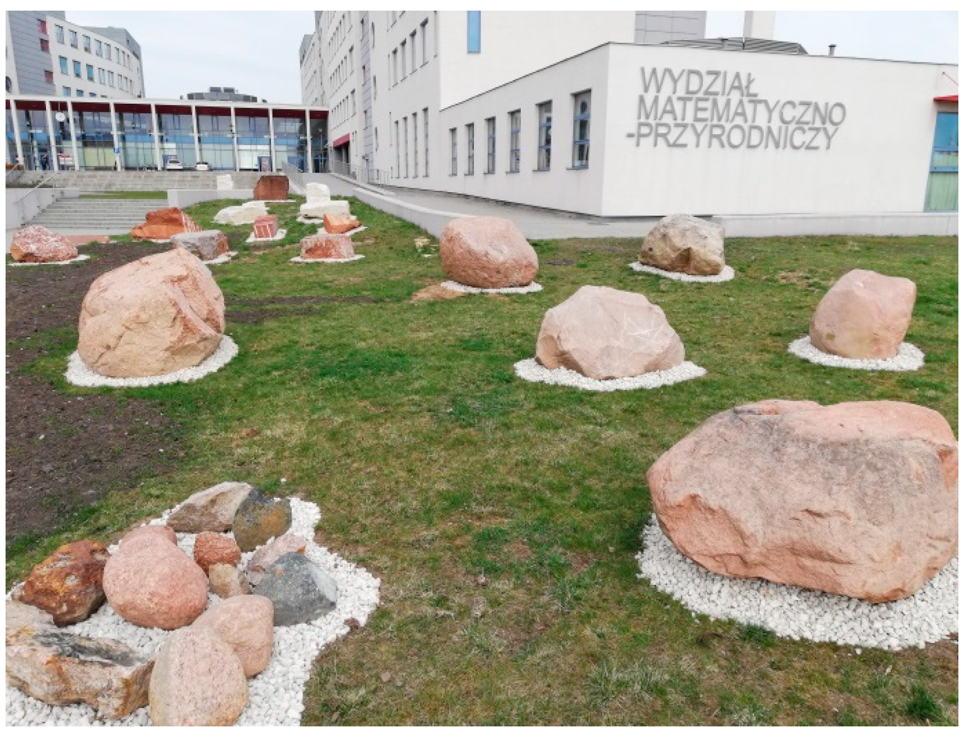
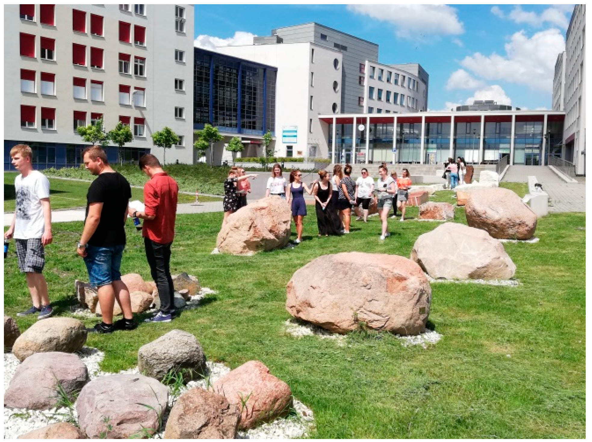
The collection of rocks is located in the inner courtyard of the campus of the Faculty of Natural Sciences of Jan Kochanowski University (JKU) in Kielce, 7 Uniwersytecka St (Figure 2). Its location is visible on the publicly available Open Street Map portal and on Google Maps. The geographic coordinates of the Rock Garden centre are 50°52′51.4″ N and 20°39′26.3″ E. Although access to the collection is unlimited, it is monitored by the department’s security services.
The Rock Garden, opened in 2019, is not a new initiative. In this place, from 2004 to 2011, there was a rock garden established by the Institute of Geography of the Holy Cross Academy (the predecessor of JKU). It contained only the Scandinavian erratics. Along with the expansion of the university campus with new buildings, the rock garden began to decline, and the collections, by a strange coincidence, disappeared or, at best, changed their locations.
Work on restoring the collection of rock objects at the Institute of Geography and Environmental Sciences (IGES) of JKU started in 2016. At that time, it was decided that the collection should also include rocks from the mines located in the Holy Cross region. According to the intention of the authorities of the faculty and the institute, the Rock Garden was to become a geological-focused scientific and educational showcase of the Kielce geographical centre.
The process of specimen collection is not yet complete. About 50 rock specimens were collected during the first stage of restoring the collection. Twenty of them come from the Kielce mines that donated them to JKU in Kielce. The exhibits come from the Morawica Limestone Mine [132], the Saspol Sandstone Mine [133], the Tumlin Sandstone Mine and the Bolechowice Limestone Mine [134].
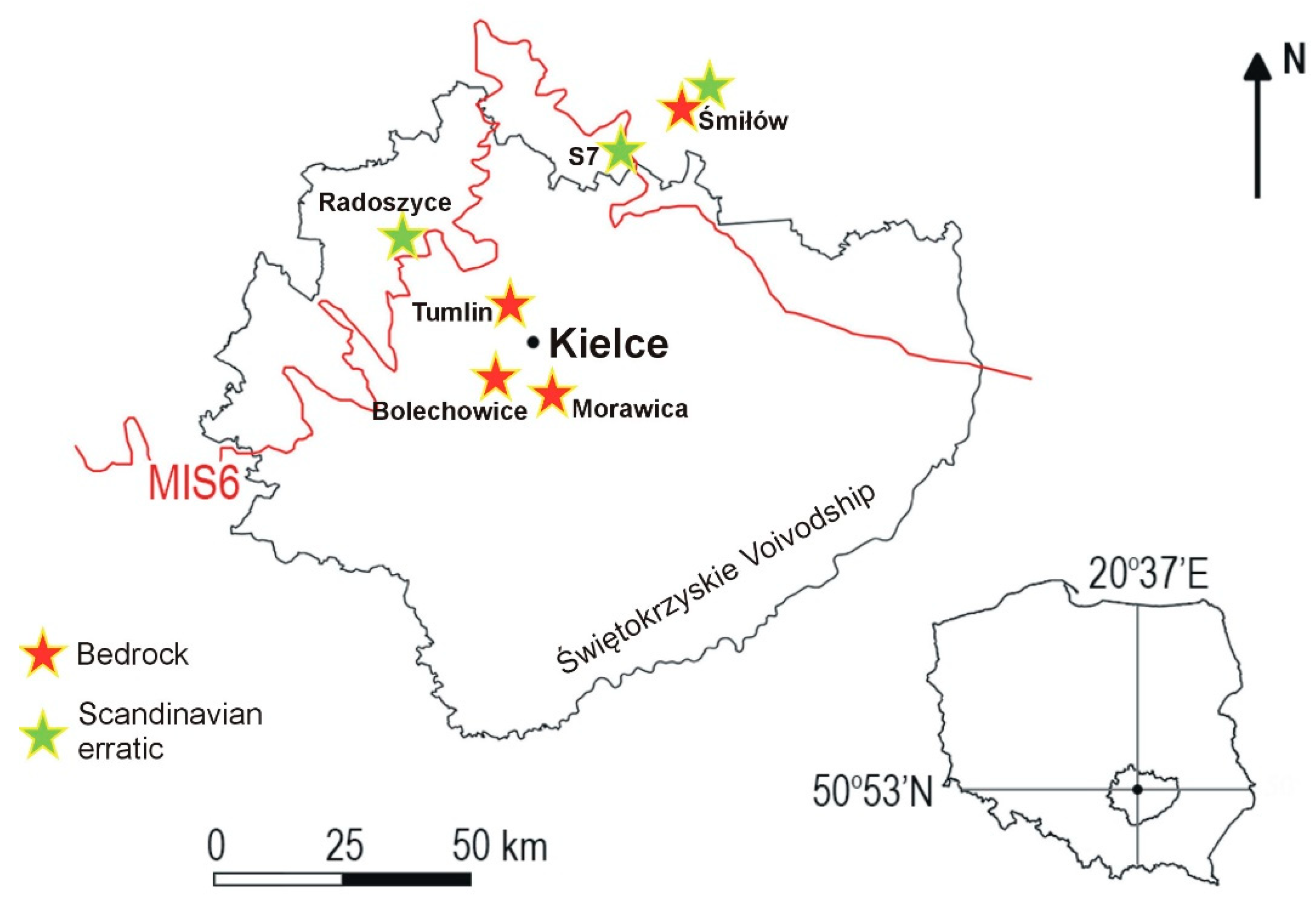
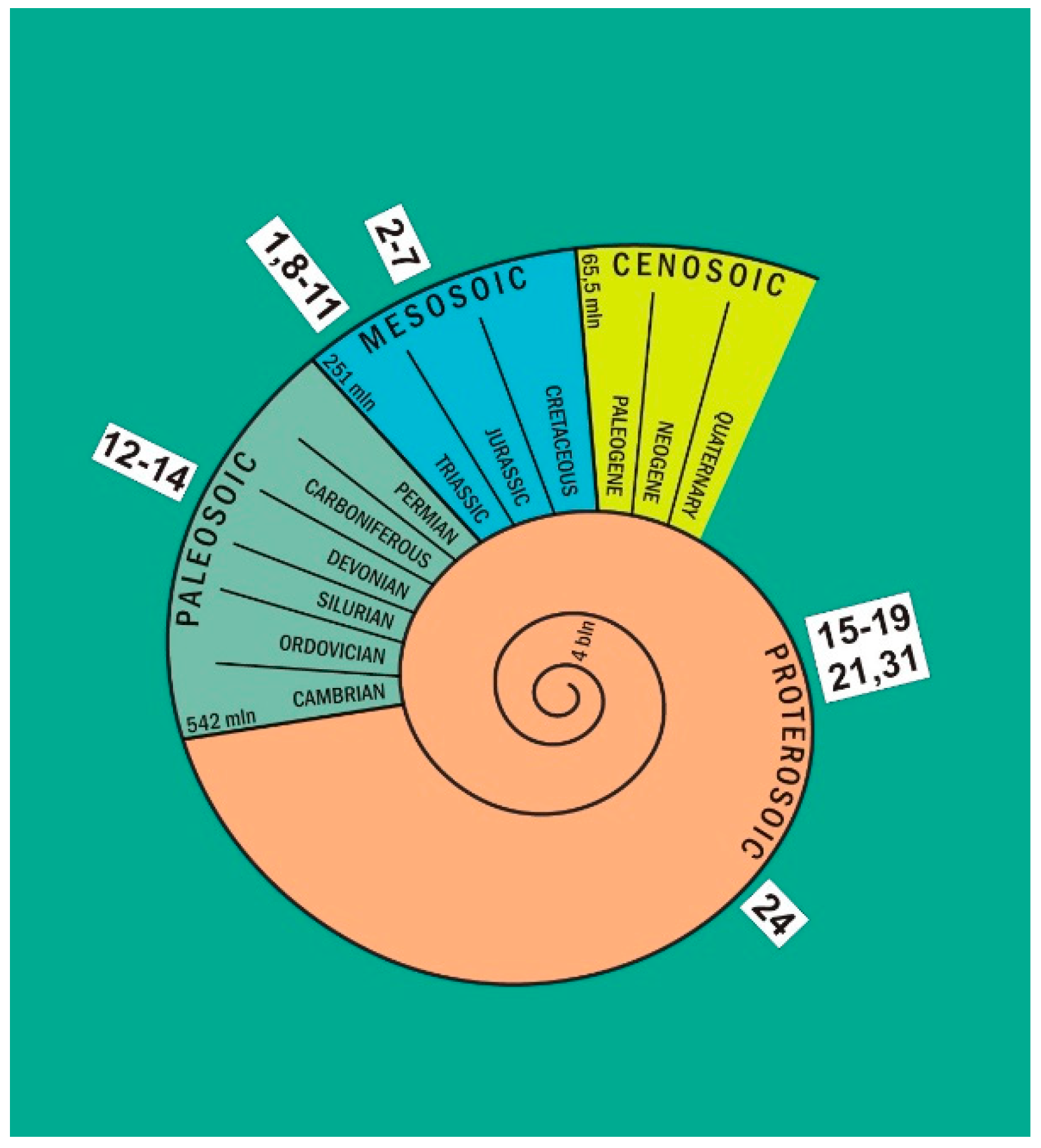
The remaining 30 specimens are erratic boulders transported to the Holy Cross region by the Scandinavian ice sheet during the South Polish Glaciation (MIS 8–16, according to [135]) and during the maximum extent of the Odranian Middle-Polish Glaciation (MIS 6, according to [2]). These include indicator erratics [40,63], the source areas of which are marked on the schematic map of Scandinavian outcrops (Figure 3). Some of the erratic boulders, especially the largest ones, were inventoried during the construction of expressway No. S7 near Szydłowiec (Figure 4) and during the construction of a small, multifunctional water retention reservoir Antoniówka (on the Plebanka River) in Radoszyce, in the western part of the Świętokrzyskie Voivodship. Some of them come from surface sediments in the Saspol Sandstone Mine in Śmiłów near Szydłowiec, and some, especially the smaller ones, belonged to the original rock collection of the Institute of Geography. Figure 4 shows the places where the specimens were collected for the Rock Garden in Kielce. The ages of some geological specimens gathered in the collection are presented schematically in Figure 5.
The rock blocks were donated to the university by the Town and Commune Office in Radoszyce [136], the Regional Directorate of National Roads and Motorways [137] and Dragados [138]. The costs of loading, transporting and distributing the rock blocks in the Rock Garden area were covered by the Morawica Limestone Mine, Zagnańsk Commune Office [139], stonemason Tadeusz Modliński [140] and the then Faculty of Mathematics and Natural Sciences, JKU. Logistic support was also provided by the company Karasiński-Dźwigi-Końskie.
The Rock Garden is described in a leaflet entitled “History written in stone” [141], which is available at the IGES of JKU. The cost of leaflet printing was covered entirely by the Faculty of Natural Sciences. The department also financed the labels that present the names and ages of the rocks and the names of the quarries they come from. These badges are attached to the objects to facilitate self-navigation through the collection (Figures 8 and 9).
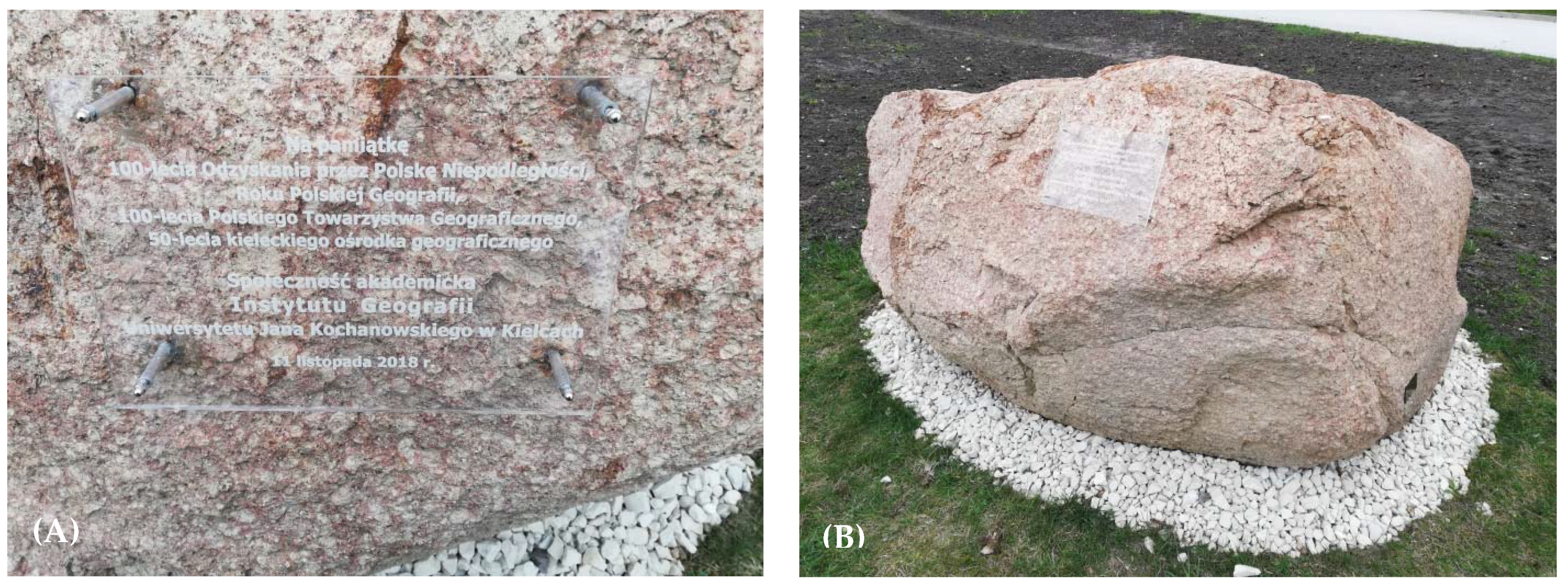
The Rock Garden was officially opened on 24 April 2019, during the annual Geographer’s Day. At that time, a commemorative plaque was unveiled (Figure 6A,B), which reminds visitors of the milestones of Kielce geography (text from the plaque: In memory of: 100th anniversary of regaining independence by Poland, Year of Polish Geography, 100th anniversary of the Polish Geographical Society, 50th anniversary of the geographical center of Kielce—academic community of the Institute of Geography, Jan Kochanowski University in Kielce, 11 November 2018). The event received wide coverage in the local press and media.
Earlier, on 13 December 2018, employees and students of the IGES took part in a ribbon-cutting ceremony using one of the Rock Garden boulders for the 100th anniversary of Poland regaining independence. The ceremony was held at the end of the commemorative scientific seminar entitled “The role of geographers and tourists in exploration of the environment of the Holy Cross region – in the service of the Independent State”. It was organized to commemorate the scientific achievements of predecessors and colleagues, geographers and sightseers of the Holy Cross region, who undertook the task of researching the geographical environment of the Kielce-Sandomierz upland on the threshold of Poland’s independence; 50 years later, the Kielce geographical centre was created.

4. Overview of Rocks in the Rock Garden of the Institute of Geography and Environmental Sciences, Jan Kochanowski University

For many reasons, the rocks in the Rock Garden are arranged in the order of their installation date, starting from the entrance board located in the northern part of the collection, and not in the stratigraphic order (Figure 5). Their location is shown in Figure 7 of the leaflet [141]. Consecutive numbers are assigned to the rocks, which will be used in this overview. All photos were taken by the author.

4.1. Holy Cross Region Rocks

No. 1. The collection of Holy Cross rocks starts with a block of Triassic sandstone from the Tumlin Mine, engraved with the inscription “Lapidarium”. It is one of the few specimens preserved from the previous rock garden.
Nos. 2–4 are three blocks of Upper Jurassic limestone from the Morawica Mine (Figure 8). The carbonate sediments (transformed into limestone due to diagenetic processes) were deposited under marine conditions in the Late Jurassic period. The limestones were formed in open-shelf environments, usually below the wave base, at depths of up to several tens of metres [142,143,144,145,146,147,148]. Apart from the dominant tuberoids (spots coloured with rotting organic matter), fragments of sponges and colonial microbial structures, the rocks contain a rich assortment of fauna consisting of bivalves, brachiopods, belemnites and ammonites [142,149,150]. A trained eye can also notice representatives of this fauna in the described specimens.
Nos. 5–7 are Lower Jurassic sandstones from the Śmiłów mine near Szydłowiec. The quartz sandstones were formed in coastal shelf environments, periodically lagoonal, in an Early Jurassic brackish basin (low-salinity marine environment) [151,152,153]. Locally, the remains of dead flora are visible in the rock [150]. Distinct ripples, formed as a result of currents in the wave zones of shallow-water basins, are visible on the surface of rock No. 7 (Figure 9), which is composed of layered sandy deposits.
Nos. 8–11 (and the already mentioned No. 1) are Lower Triassic sandstones from a quarry on Góra Grodowa Mountain near Tumlin. These are dune sediments, cemented with hematite-silica and then litified, which testify to the existence of a hot and dry climate in the Early Triassic in the area of today’s Holy Cross Mountains [150,151,154,155,156,157]. The sediments were deposited as a result of migration of transverse dunes or barchans raised by southerly winds. Specimen Nos. 8–10 display large-scale cross bedding, resulting in good platy parting.
Nos. 12 and 13 are Upper Devonian limestones from the Bolechowice quarry. They were formed in marine shelf, lagoonal environments below the wave base, which extended to the edge of a shallow-water reef area (151,158,159]. The limestones contain numerous fossils of primitive Stromatopora and Amphipora sponges with clearly visible structures [157] and, less frequently, those of Megalodon brachiopods [158,159]. Due to their good susceptibility to polishing and the interesting structure (Figure 10) [151,160,161], the term “Holy Cross Marbles” is commonly used when referring to the Devonian limestones of the Holy Cross region, which is inconsistent with their petrographic affiliation.
No. 14 is a fragment of the Late Permian Sigismundus (Zygmuntowski) conglomerate composed of limestone debris, formed as a result of intense erosion of the Holy Cross orogen in the Late Carboniferous period and throughout Early Permian times. Pieces of the limestones, after being transported over short distances, were deposited as alluvial cones and coastal deposits of a transgressing sea in the Late Permian [151,156,162,163]. The limestone fragments are cemented by clay-calcareous cement with admixtures of iron oxides and hydroxides that are responsible for the red colour (Figure 10) [150,157,163]. The original core of the King Sigismund’s Column in Warsaw was made of the conglomerate. During the general restoration of the monument from 1885 to 1889, the weathered core was replaced with a granite one. Today, the original fragments of the column lie in the square in front of the side entrance to the courtyard of the Royal Castle in Warsaw.

4.2. Scandinavian Erratic Rocks

Within the courtyard square, starting from No. 16, Scandinavian erratic rocks have been placed. Among them, plutonic rocks (e.g., Nos. 15–19, 21, 31) dominate. Another group of rocks presented here in large numbers is metamorphic rocks (e.g., Nos. 20, 30). The group of rocks presented in the Rock Garden that were brought by the Scandinavian ice sheet includes only two specimens of sedimentary rocks. These are Precambrian sandstones, the so-called Jotnian sandstones, representing the group of nine rocks marked as No. 24 in the leaflet’s [141] schematic map.
Some of the erratic rocks in the Rock Garden come from a specific (unique) outcrop in Scandinavia. They are therefore indicator erratics. Such erratics are rapakivi granites from the Åland Islands (Nos. 16–17 and 31; Figure 3). They are easily recognizable due to their characteristic texture and structure of minerals [61,64,164]; large alkaline feldspars (5–15 mm), generally ovoid in shape and with plagioclase rims, are clearly visible in the red-brown rock groundmass (Figure 12). They are most often the same or a slightly lighter in colour in relation to the rock groundmass. The plagioclase rim (narrower around smaller ovoids, wider around larger ones) is grey-green in colour; weathering processes have changed its colour to almost white. Quartz crystals are rare (the more frequent feldspars are, the less frequent quartz crystals are), very well rounded and smoky grey, and their size ranges from 1 to 10 mm.
Indicator erratics are also represented by the Småland granites from south-eastern Sweden. In the Rock Garden, these rocks are numbered 15, 18–19 and 21 (Figure 3). They are characterized by being multi-coloured, especially the intense red colour of potassium feldspar [61,64,164]. An important distinguishing feature is the presence of bluish quartz [71].
The surfaces of the rocks show traces of morphogenetic processes that affected the boulder in the ice-marginal area of the melting ice sheet. Therefore, characteristic parallel aeolian micro-ribs are visible on the boulders (Nos. 16 (Figure 11 and Figure 12) and 18), which are the result of corrosion (erosion/grinding) of the furrows by sand grains and/or snow/ice crystals carried by the wind in a dry and frosty periglacial environment [165]. Other specimens (Nos. 15 and 21) are rounded/oval in shape, which is the result of glacial transport and erosive activity of meltwater in intra-glacial tunnels. The record of grinding (detersion) of part of the boulder against the crystalline bedrock, over which it was transported at the base of the ice sheet, can be recognized thanks to the glacially polished surfaces on three specimens in the Rock Garden (Nos. 19, 26 and 31). The record of subglacial erosion may also be a result of abrasion of the surface of the boulder anchored in the bedrock when the ice sheet was advancing over it.

5. Conclusions

The Rock Garden of the IGES at JKU in Kielce currently (as of 2020) contains about 50 specimens of rocks from the Holy Cross region and Scandinavian erratics that were brought by ice sheets to the surroundings of Kielce.
Located in the immediate vicinity of the IGES, although it has been functioning for only one year now, the Rock Garden already serves as a didactic facility for students of geography, tourism and recreation, and environmental protection. Students carry out activities here provided by the curriculum (Figure 13). In March 2020, field geomorphological workshops of IGES were organized in the Rock Garden. They accompanied the first edition of Geomorphology Week, which is an event organized periodically under the auspices of the Association of Polish Geomorphologists [166]. Workshop participants learned to recognize the basic petrographic types of rocks (Figure 14) and were acquainted with the geological and cultural heritage of the Holy Cross region. Were it not for the limitations imposed by COVID-19, the rock collection would be presented during annual events popularizing earth sciences, such as Geographer’s Day, Tourism Days, and GIS Day. This is also where the students at the Open University of JKU were to have their lectures. The hosts do not lose hope that it will eventually be possible to offer lectures, workshops, courses, shows, geocaching/quests, TRInO, etc., to children and adults (e.g., as part of the statutory activities of the Polish Geographical Society). On the one hand, these methods will be excellent forms of popularizing research conducted at JKU; on the other hand, they will respond to the cognitive and educational needs of the local community.
The collection of rocks is accessible to any visitor who can arrive by public transport or by car, which can be left in the nearby parking lot. In addition, the availability of food in the student canteen and a convenient place to rest make the Rock Garden a facility of great tourist potential. Over 4000 views of the Lapidarium website [167] in just one year of its operation is a good omen for the future.
The Rock Garden of the IGES of JKU is another item in the list of urban geotourism in Kielce, encouraging residents of the city and the region to learn about the rich geological heritage of the Kielce region. The others are five inanimate nature reserves [168], the Jan Czarnocki Holy Cross Branch of the Polish Geological Institute—National Research Institute and the Geoeducation Centre (of the planned UNESCO Global Geopark Holy Cross Mountain). Its integral element in the Holy Cross region is rock mining. At the Rock Garden, visitors can learn about the centuries-old tradition of managing the resources of inanimate nature. Thus, the collection of rocks enhances the geographical character of the place, becoming a clear showpiece of the region.
The presence of examples of rock blocks from surrounding areas in the Rock Garden of the IGES at JKU is a unique way for visitors to gain a better appreciation of geological materials, their uses and the local natural environment. Visitors have the educational and recreational opportunity to observe local rocks within a pleasant urban environment.
Finally, undertaking local initiatives aimed at disseminating all geotouristic values of the region among the inhabitants will certainly contribute to drawing attention to the need to protect the georesources of the Earth in Poland to a greater extent than what has been done so far. The Rock Garden, as a unique facility will undoubtedly contribute to the urban geotourism in Kielce and the city sourroundings.

Funding

This research received no external funding.

Institutional Review Board Statement

Not applicable.

Informed Consent Statement

Not applicable.

Data Availability Statement

Not applicable.

Acknowledgments

The author would like to acknowledge all institutions in Kielce and surroundings that donated the geological specimens to the Rock Garden. The Dean of the Faculty, Barbara Gawdzik, is a very sensitive person to the beauty of inanimate nature – the author really appreciates her comprehensive support. The four reviewers are thanked for their valuable input, which greatly helped to improve the paper. Zbigniew Złonkiewicz from Polish Geological Institute National Research Institute is thanked for the references support, Małgorzata Gościńska-Kolanko—for drawing the pictures Nos. 1 and 3–5. Krzysztof Leszczyński translated the text and Scribendi corrected the English version of the text.

Conflicts of Interest

The author declare no conflict of interest.

References

  1. Nature Conservation Act of 2004. Available online: http://prawo.sejm.gov.pl/isap.nsf/download.xsp/WDU20180001614/U/D20181614Lj.pdf (accessed on 2 December 2020).
  2. Marks, L.; Bińka, K.; Woronko, B.; Majecka, A.; Teodorski, A. Revision of the Late Middle Pleistocene stratigraphy and palaeoclimate in Poland. Quat. Int. 2019, 534, 5–17. [Google Scholar] [CrossRef]
  3. Górska-Zabielska, M. The most valuable erratic boulders in the Wielkopolska region of western Poland and their potential to promote geotourism. Geoj. Tour. Geosites 2020, 29, 694–714. [Google Scholar] [CrossRef]
  4. Górska-Zabielska, M.; Witkowska, K.; Pisarska, M.; Musiał, R.; Jońca, B. The Selected Erratic Boulders in the Świętokrzyskie Province (Central Poland) and Their Potential to Promote Geotourism. Geoheritage 2020, 12, 1–14. [Google Scholar] [CrossRef] [Green Version]
  5. Schulz, W. Geologischer Führer für den Norddeutschen Geschiebesammler; CW Verlagsgruppe: Schwerin, Germany, 2003; p. 508. [Google Scholar]
  6. Marks, L. Timing of the Late Vistulian (Weichselian) glacial phases in Poland. Quat. Sci. Rev. 2012, 44, 81–88. [Google Scholar] [CrossRef]
  7. Hardt, J. Weichselian phases and ice dynamics of the Scandinavian Ice Sheet in northeast Germany: A reassessment based on geochronological and geomorphological investigations in Brandenburg. E&G Quat. Sci. J. 2017, 66, 101–102. [Google Scholar] [CrossRef] [Green Version]
  8. Cohen, K.M.; Gibbard, P.L. Global chronostratigraphical correlation table for the last 2.7 million years, version 2019 QI-500. Quat. Int. 2019, 500, 20–31. [Google Scholar] [CrossRef]
  9. Piotrowski, K. Dobry pomysł na biznes. Kamieniarstwo “głazowe”. Nowy Kamieniarz 2008, 34, 58–62. [Google Scholar]
  10. Chrząszczewski, W. Stoneman spod Konina. Nowy Kamieniarz 2009, 43, 40–44. [Google Scholar]
  11. Górska-Zabielska, M.; Zabielski, R. Potential values of urban geotourism development in a small Polish town (Pruszków, Central Mazovia, Poland). Quaest. Geogr. 2017, 36, 75–86. [Google Scholar] [CrossRef] [Green Version]
  12. Górska-Zabielska, M.; Zabielski, R. Geotourism Development in an Urban Area based on the Local Geological Heritage (Pruszków, Central Mazovia, Poland). In Urban Geomorphology. Landforms and Processes in Cities; Thornbush, M.J., Allen, C.D., Eds.; Elsevier: Amsterdam, The Netherlands, 2018; pp. 37–54. [Google Scholar] [CrossRef]
  13. Skoczylas, J.; Skoczylas, Ł. Kamienne bruki Starego Rynku w Poznaniu jako element dziedzictwa kulturowego. Przegląd Geol. 2020, 68, 535–539. [Google Scholar] [CrossRef]
  14. Skoczylas, J.; Skoczylas, Ł. Kamienne bruki Górnego Miasta w Poznaniu. Przegląd Geol. 2020, 68, 774–779. [Google Scholar] [CrossRef]
  15. Górska-Zabielska, M. Analiza petrograficzna głazów narzutowych w grobowcu megalitycznym w Kierzkowie. In Megalityczny Grobowiec Kultury Amfor Kulistych z Kierzkowa na Pałukach; Pospieszy, Ł., Sobkowiak-Tabaka, I., Nowaczyk, S., Eds.; Milczący świadek kultu przodków w epoce kamienia; Wydawnictwo: Biskupin, Poland, 2017; pp. 71–102. [Google Scholar]
  16. Chachlikowski, P. Surowce Eratyczne w Kamieniarstwie Społeczeństw Wczesnoagrarnych Niżu Polskiego (IV–III tys. przed Chr.); Uniwersytet im. Adama Mickiewicza: Poznań, Poland, 2013; 357p. [Google Scholar]
  17. Chachlikowski, P. Użytkowanie surowców kamiennych. In Wczesnośredniowieczna Osada w Wilenku, gm. Szczaniec Wraz z Pozostałościami Osadnictwa Nowożytnego. Archeologiczne Badania Ratownicze na Trasie Autostrady A2; Dębski, A., Ed.; Via Archaeologica Posnanienses: Poznań, Poland, 2014; Volume 10, pp. 109–130. [Google Scholar]
  18. Jarzewicz, J. Gotycka Architektura Nowej Marchii. Budownictwo Sakralne w Okresie Askańczyków i Wittelsbachów; Pozn. Tow. Przyj. Nauk, Prace Komisji Historii Sztuki: Poznań, Poland, 2000; Volume 29, 366p. [Google Scholar]
  19. Król, D.; Woźniak, P.P.; Zakrzewski, L. Kamienie Szwedzkie w Kulturze i sztuce Pomorza; Muzeum Archeologiczne w Gdańsku: Gdańsk, Poland, 2004; 72p. [Google Scholar]
  20. Meyer, K.-D. Die Findlinge und Findlingsgärten in Niedersachsen. Schr. Dtsch. Ges. Geowiss. 2008, 56, 117–122. [Google Scholar]
  21. Skibiński, S. Pomorze Zachodnie i Nowa Marchia. In Architektura Gotycka w Polsce; Instytut Sztuki Polskiej Akademii Nauk: Warszawa, Poland, 1995. [Google Scholar]
  22. Skibiński, S. Technika grubego muru” w średniowiecznej architekturze Pomorza Zachodniego. In Ars Sine Scientia Nihil Est, Księga Ofiarowana Profesorowi Zygmuntowi Świechowskiemu; Dom Wydawniczy ARS: Warszawa, Poland, 1997. [Google Scholar]
  23. Skibiński, S. Architektura południowego pobrzeża Bałtyku w XIII wieku. In Civitas Cholbergiensis. Transformacja Kulturowa w Strefie Nadbałtyckiej w XIII w.; Wydawn. Le Petit Cafe: Kołobrzeg, Poland, 2005. [Google Scholar]
  24. Skoczylas, J. Budowa geologiczna i surowce mineralne regionu jeziora Lednickiego. Studia Lednickie 1989, 1, 209–224. [Google Scholar]
  25. Skoczylas, J. Użytkowanie surowców skalnych we wczesnym średniowieczu w północno-zachodniej Polsce. Zeszyty UAM, Seria Geologia 1990, 12, 138p. [Google Scholar]
  26. Skoczylas, J. Geologia a historia kultury materialnej w Wielkopolsce. Przegląd Geol. 1991, 39, 337–340. [Google Scholar]
  27. Skoczylas, J. Surowce skalne we wczesnym średniowieczu. Przegląd Geol. 1991, 39, 364–365. [Google Scholar]
  28. Skoczylas, J. Wykorzystanie surowców skalnych w średniowiecznej architekturze Lubinia koło Gostynia. Geologos 1996, 1, 203–213. [Google Scholar]
  29. Skoczylas, J.; Walendowski, H. Kamień w zabytkowej architekturze Ostrowa Tumskiego w Poznaniu. Przegląd Geol. 1998, 46, 1146–1152. [Google Scholar]
  30. Świechowski, Z. Architektura Granitowa Pomorza Zachodniego w XIII Wieku; Pozn. Tow. Przyj. Nauk, Prace Komisji Historii Sztuki: Poznań, Poland, 1950; Volume 2, 112p. [Google Scholar]
  31. Świechowski, Z. Architektura Romańska w Polsce; Wyd. DiG: Warszawa, Poland, 2000; 674p. [Google Scholar]
  32. Alexandrowicz, Z. Międzynarodowe inicjatywy w ochronie przyrody nieożywionej. Przegląd Geol. 1994, 42, 159–161. [Google Scholar]
  33. Kostrzewski, A. Georóżnorodność rzeźby jako przedmiot badań geomorfologii. In Główne Kierunki Badań Geomorfologicznych w Polsce. Stan Aktualny i Perspektywy. IV Zjazd Geomorfologów Polskich, Referaty i Komunikaty; Pękala, K., Ed.; Institute of Geography and Spatial Organization PAS (Polish Academy of Science): Lublin, Poland, 1998; pp. 11–16. [Google Scholar]
  34. Kozłowski, S. Geodiversity. The concept and scope of geodiversity. Przegląd Geol. 2004, 52, 833–837. [Google Scholar]
  35. Kozłowski, S.; Migaszewski, M.; Gałuszka, A. Geodiversity conservation—Conservating our geological heritage. Pol. Geol. Inst. Spec. Pap. 2004, 13, 13–20. [Google Scholar]
  36. Migoń, P. Geomorfologia w ochronie dziedzictwa przyrodniczego i kulturowego—Wymiar globalny i lokalny. Landf. Anal. 2008, 9, 25–29. [Google Scholar]
  37. Gray, M. Geodiversity: Valuing and Conserving Abiotic Nature, 2nd ed.; Wiley Blackwell: Chichester, UK, 2013. [Google Scholar]
  38. Gray, M. Geodiversity: The backbone of geoheritage and geoconservation. In Geoheritage: Assessment, Protection, and Management; Reynard, E., Brilha, J., Eds.; Elsevier: Amsterdam, The Netherlands, 2018; pp. 13–25. [Google Scholar]
  39. Zwoliński, Z.; Najwer, A.; Giardino, M. Methods for assessing geodiversity. In Geoheritage: Assessment, Protection, and Management; Reynard, E., Brilha, J., Eds.; Elsevier: Amsterdam, The Netherlands, 2018; pp. 27–52. [Google Scholar]
  40. Górska-Zabielska, M. Fennoskandzkie Obszary Alimentacyjne Osadów Akumulacji Glacjalnej i Glacjofluwialnej Lobu Odry; Wyd. Nauk. UAM: Poznań, Poland, 2008; Volume 78, 330p. [Google Scholar]
  41. Górska-Zabielska, M. Ochrona głazów narzutowych w Wielkopolskim Parku Narodowym. Probl. Ekol. Kraj. 2011, 29, 141–149. [Google Scholar]
  42. Górska-Zabielska, M. Nowe obiekty geoturystyczne na południowym Podlasiu [New geotourist objects in southern Podlasie]. Przegląd Geol. 2020, 68, 91–99. [Google Scholar]
  43. Jóźwiak, K.; Stępień, M. Petrografia okolic Drawnika. In Ekomuzeum Rzeki Drawy. Geościeżka w Dolinie Drawy; Bąkowska, A., Ed.; Drawieński Park Narodowy: Drawno, Poland, 2013; pp. 50–78. [Google Scholar]
  44. Szarzyńska, A. Wzgórza Dylewskie terenową wystawą muzealną głazów narzutowych. Nat. Przyr. Warm. Mazur 2015, 4, 26–37. [Google Scholar]
  45. Górska-Zabielska, M.; Dobracki, R. Petrographic Garden in Moryń—A new geotouristic attraction in western Poland. Landf. Anal. 2015, 29, 73–80. [Google Scholar] [CrossRef]
  46. Meyer, K.-D. Der Findlingsgarten von Hagenburg am Steinhuder Meer. Ur-Und Frühzeit 1981, 2, 4–13. [Google Scholar]
  47. Meyer, K.-D. Der Findlingsgärten in Niedersachsen. Arch. Geschiebekd. 2006, 5, 323–338. [Google Scholar]
  48. Krempien, W.; Schulz, W. Geologische Sammlungsbestände in Museen Mecklenburg-Vorpommerns. Mitt. Nat. Ges. West-Mecklenbg. 2008, 8, 3–24. [Google Scholar]
  49. Koźma, J. Transgraniczny Geopark Łuk Mużakowa. Przegląd Geol. 2011, 59, 276–290. [Google Scholar]
  50. Koźma, J. Geoturystyczne walory krajobrazu Łuku Mużakowa. Górnictwo Odkryw. 2017, 3, 32–40. [Google Scholar]
  51. Börner, A. Mecklenburgische Eiszeitlandschaft. Rinnenseen und Riesensteine. Streifzüge Durch Die Erdgeschichte; Quelle & Meyer Verlag: Wiebelsheim, Germany, 2012. [Google Scholar]
  52. Börner, A. Mecklenburgische Seenplatte. Eiszeitmeer und Lesesteine. Streifzüge durch Die Erdgeschichte; Quelle & Meyer: Wiebelsheim, Germany, 2013. [Google Scholar]
  53. Keiter, M. Die “Großen Sieben” und der neue Findlingsgarten in Bielefeld—Botschafter vom saalezeitlichen Eisrand. Geschiebekd. Aktuell 2017, 33, 119–129. [Google Scholar]
  54. Ciupa, T.; Suligowski, R.; Sutowicz-Kwiecińska, M. Ujęcie siarczkowych wód leczniczych i lapidarium w Uzdrowiskowym Zakładzie Górniczym, Las Winiarski” nową atrakcją geoturystyczną w okolicach Buska Zdroju. Studia Mater. Misc. Oeconomicae 2017, 1, 93–105. [Google Scholar]
  55. Mader, A.; Bąk, E. Walory edukacyjne Muzeum Geologicznego przy Oddziale Świętokrzyskim Państwowego Instytutu Geologicznego—PIB w Kielcach. In Geoprodukt. 5 Ogólnopolskie Forum, Popularyzacja Geoturystyki; Państwowy Instytut Geologiczny, Państwowy Instytut Badawczy: Zabrze, Poland, 2019; pp. 10–11. [Google Scholar]
  56. Muszer, J. Georetum w Arboretum w Wojsławicach—Punkt wycieczkowy nr 5. XXIV Konferencja Naukowa Sekcji Paleontologicznej PTG; Uniwersytet Wrocławski: Wrocław, Poland, 2019; pp. 119–125. [Google Scholar]
  57. Krzeczyńska, M.; Wierzbowski, A.; Woźniak, P.; Świło, M.; Chećko, A. Działania Muzeum Geologicznego Państwowego Instytutu Geologicznego—Państwowego Instytutu Badawczego prowadzone w celu wykorzystania edukacyjnego i ochrony starych kamieniołomów. Przegląd Geol. 2020, 68, 187–193. [Google Scholar]
  58. Elmi, C.; Simal, A.G.; Winchester, G.P. Developing a Rock Garden at Edith J. Carrier Arboretum, Harrisonburg VA (U.S.A.) as a Resource for Promoting Geotourism. Geosciences 2020, 10, 415. [Google Scholar] [CrossRef]
  59. Available online: https://muzeum.chrzanow.pl/old/_files_/_przewodnik_po_ogrodzie__czesc_1.1.pdf (accessed on 12 December 2020).
  60. Available online: https://muzeum.chrzanow.pl/old/_files_/_przewodnik_po_ogrodzie__czesc_1.2.pdf (accessed on 12 December 2020).
  61. Czubla, P.; Gałązka, D.; Górska, M. Eratyki przewodnie w glinach morenowych Polski. Przegląd Geol. 2006, 54, 352–362. [Google Scholar]
  62. Korn, J. Die Wichtigste Leitgeschiebe der Nordischen Kristallinen Gesteine im Norddeutschen Flachlande; Preußische Geologische Landesanstalt: Berlin, Germany, 1927. [Google Scholar]
  63. Lüttig, G. Methodische Fragen der Geschiebeforschung. Geol. Jahrb. 1958, 75, 361–418. [Google Scholar]
  64. Meyer, K.-D.; Lüttig, G. Was verstehen wir unter einem “Leitgeschiebe”? Geschiebekd. Aktuell 2007, 23, 106–121. [Google Scholar]
  65. Sederholm, J.J. Über die finnländischen Rapakiwigesteine. In Tschermak’s Mineralogischen und Petrographischen; Hölder, A., Ed.; Mittheilungen NF: Vienna, Austria, 1891; Volume 12, pp. 1–31. [Google Scholar]
  66. Hesemann, J. Zur Petrographie einiger nordischer kristalliner Leitgeschiebe. Abh. preuss. geol. Landesanst. NF 173: Berlin, Germany, 1936; p. 167. [Google Scholar]
  67. Hesemann, J. Zur Petrographie weiterer hauptsächlich ost-fennoskandischer Leitgeschiebe. Zeitschrt. Geschiebeforschung 1939, 15, 68–98. [Google Scholar]
  68. Hesemann, J. Kristalline Geschiebe der nordischen Vereisungen; Geologisches Landesamt Nordrhein-Westphalen: Krefeld, Germany, 1975; p. 267. [Google Scholar]
  69. Vinx, R. Granatcoronit (mafischer Granulit): Ein neues Leitgeschiebe SW-schwedischer Herkunft. Archiv f. Geschiebekunde 1996, 2, 3–20. [Google Scholar]
  70. Vinx, R. Neue kristalline SW-Schwedische Leitgeschiebe: Granoblastischer mafischer Granulit, Halland-Retro-Eklogit und deformierter, bunter Pegmatit. Arch. f. Geschiebekunde 1998, 2, 363–378. [Google Scholar]
  71. Bartholomäus, W.A.; Solcher, J. The less known properties of blue quartz. Geschiebekd. Aktuell 2002, 18, 99–106. [Google Scholar]
  72. Schulz, W. Rhombenporphyr-Geschiebe und deren östliche Verbreitungsgrenze im nordeuropäischen Vereisungsgebiet. Z. Die Geol. Wiss. 1973, 9, 1141–1154. [Google Scholar]
  73. Vinx, R. Hochauflösende Rekonstruktion von Eistransportwegen: Die “Leitserienmethode”. Archiv f. Geschiebekunde 1993, 1, 625–640. [Google Scholar]
  74. Meyer, K.-D. Zur Entstehung der westlichen Ostsee. Geol. Jahrb. 1991, 127, 429–446. [Google Scholar]
  75. Lüttig, G. Geschiebestatistische Anmerkungen zur Quartärstratigraphie des nordischen Vereisungsgebietes. Eiszeitalt. Ggw. 1999, 49, 144–163. [Google Scholar]
  76. Górska, M. Petrographie von uckermärkischen Geschieben. Geologische Brandenburgische Beiträge. Neubrandenburg 2002, 3, 35–47. [Google Scholar]
  77. Górska, M. Nowe znalezisko porfiru rombowego z Oslo na terenie północno-zachodniej Polski. [A new found of Oslo romb porphyry in north-western Poland]. Przegląd Geol. 2003, 51, 580–585. [Google Scholar]
  78. Górska, M. Fennoscandian erratics in glacial deposits of the Polish Lowland—Methodical aspects. Studia Quat. 2006, 23, 11–15. [Google Scholar]
  79. Czubla, P.; Forysiak, J.; Twardy, J. Diamicton in Besiekierz (Central Poland)—How to avoid misinterpretation of superposition in Quaternary geology. Geol. Q. 2013, 57, 629–636. [Google Scholar]
  80. Strzelecki, P.J. The provenance of erratic pebbles from a till in the vicinity of the city of Radom, central Poland. Geol. Geophys. Environ. 2019, 45, 21–29. [Google Scholar] [CrossRef]
  81. Górska-Zabielska, M. Najcenniejsze głazy narzutowe w Wielkopolsce i ich potencjał geoturystyczny. Przegląd Geol. 2015, 63, 455–463. [Google Scholar]
  82. Böse, M. Reconstruction of ice flow directions south of the Baltic Sea during the Saalian and Weichselian Glaciations. Boreas 1990, 19, 217–226. [Google Scholar] [CrossRef]
  83. Böse, M.; Górska, M. Lithostratigraphical studies in the outcrop at Ujście, Toruń-Eberswalde Pradolina, western Poland. Eiszeitalt. Ggw. 1995, 45, 1–14. [Google Scholar]
  84. Meyer, K.-D. Entfernung von Findlinge in Kanada und Vergleich mit Nordeuropa. Eiszeitalt. Ggw. 1990, 40, 126–138. [Google Scholar]
  85. Meyer, K.-D. Rhombenporphyre an Englands und Schottlands Ostküste. Der Geschiebesammler 1993, 26, 9–17. [Google Scholar]
  86. Meyer, K.-D. Geschiebekundlich-stratigraphische Untersuchungen im Hannoverschen Wendland (Niedersachsen). Brand. Geowiss. Beiträge 2000, 7, 115–125. [Google Scholar]
  87. Meyer, K.-D. Zur Stratigraphie des Saale-Glazials in Niedersachsen und zu Korrelationsversuchen mit Nachbargebieten. Eiszeitalt. Ggw. 2005, 55, 25–42. [Google Scholar] [CrossRef]
  88. Lüttig, G. Erratic boulder statistics as a stratigraphic aid e examples from Schleswig-Holstein. Newsl. Stratigr. 1991, 25, 61–74. [Google Scholar] [CrossRef]
  89. Czubla, P. Eratyki fennoskandzkie w utworach czwartorzędowych Polski Srodkowej i ich znaczenie stratygraficzne. Acta Geogr. Lodz. 2001, 80, 174. [Google Scholar]
  90. Czubla, P. The stratigraphic significance of indicator erratics counts from glacial deposits e an example from Eastern Wielkopolska (Great Poland Lowland). Arch. Geschiebekd. 2006, 5, 177–190. [Google Scholar]
  91. Czubla, P. Eratyki Fennoskandzkie w Osadach Glacjalnych Polski i Ich Znaczenie Badawcze; Wydawnictwo Uniwersytetu Łódzkiego: Łódź, Poland, 2015; 335p. [Google Scholar]
  92. Gałązka, D. Zastosowanie Makroskopowych Badań Eratyków do Określenia Stratygrafii Glin Lodowcowych Środkowej i Północnej Polski. Ph.D. Thesis, Archiwum Wydziału Geologii Uniwersytet Warszawski, Warszawa, Poland, 2004; 255p. [Google Scholar]
  93. Woźniak, P.P.; Czubla, P. The late Weichselian glacial record in northern Poland: A new look at debris transport routes by the Fennoscandian ice sheet. Quat. Int. 2015, 386, 3–17. [Google Scholar] [CrossRef]
  94. Czubla, P.; Terpiłowski, S.; Orłowska, A.; Zieliński, P.; Zieliński, T.; Pidek, I.A. Petrographic features of tills as a tool in solving stratigraphical and palaeogeographical problems—A case study from Central-Eastern Poland. Quat. Int. 2019, 501, 45–58. [Google Scholar] [CrossRef]
  95. Górska-Zabielska, M.; Smolska, E.; Wachecka-Kotkowska, L. Analiza petrograficzna narzutniaków w żwirowni Łubienica-Superunki oraz ich skandynawskie obszary alimentacyjne. Przegląd Geol. 2021, 69, 43–54. [Google Scholar] [CrossRef]
  96. Reynard, E. Protecting stones: Conservation of erratic blocks in Switzerland. In Dimension Stone. New Perspectives for a Traditional Building Material; Prikryl, R., Ed.; Balkema: Leiden, The Netherlands, 2004; pp. 3–7. [Google Scholar]
  97. Ivy-Ochs, S.; Kober, F. Surface exposure dating with cosmogenic nuclides. Eiszeitalt. Ggw. Quatern. Sci. J. 2008, 57, 179–209. [Google Scholar] [CrossRef] [Green Version]
  98. Rinterknecht, V.; Marks, L.; Piotrowski, J.A.; Raisbeck, G.M.; Yiou, F.; Brook, E.J.; Clark, P.U. Cosmogenic 10Be ages on the Pomeranian Moraine, Poland. Boreas 2005, 34, 186–191. [Google Scholar] [CrossRef]
  99. Rinterknecht, V.; Braucher, R.; Böse, M.; Bourlès, D.; Mercier, J.-L. Late Quaternary ice sheet extents in northeastern Germany inferred from surface exposure dating. Quatern. Sci. Rev. 2012, 44, 89–95. [Google Scholar] [CrossRef]
  100. Tylmann, K.; Woźniak, P.P.; Rinterknecht, V.R. Erratics selection for cosmogenic nuclide exposure dating—An optimization approach. Baltica 2018, 31, 100–114. [Google Scholar] [CrossRef]
  101. Tylmann, K.; Rinterknecht, V.R.; Woźniak, P.P.; Bourlès, D.; Schimmelpfennig, I.; Guillou, V.; Team ASTER. The local Last Glacial Maximum of the southern Scandinavian Ice Sheet front: Cosmogenic nuclide dating of erratics in northern Poland. Quat. Sci. Rev. 2019, 219, 36–46. [Google Scholar] [CrossRef]
  102. Available online: https://alberta.preserve.ucalgary.ca/sites/okotoks-erratic-big-rock/ (accessed on 8 January 2021).
  103. Jackson, L.E. The Foothills Erratics Train Region. In Landscapes and Landforms of Western Canada. World Geomorphological Landscapes; Slaymaker, O., Ed.; Springer: Cham, Switzerland, 2017. [Google Scholar] [CrossRef]
  104. Górska-Zabielska, M.; Nowicka, N.; Zawieja, J. Georóżnorodność i walory geoturystyczne Drawieńskiego Parku Narodowego, NW Polska. Biul. Państwowego Instytutu Geol. Państwowego Inst. Badaw. 2015, 463, 1–42. [Google Scholar] [CrossRef]
  105. Czernicka-Chodkowska, D. Zabytkowe Głazy Narzutowe na Obszarze Polski. Część III, Polska Południowo-Wschodnia i Południowa; Wydawnictwa Geologiczne: Warszawa, Poland, 1980; 78p. [Google Scholar]
  106. Czernicka-Chodkowska, D. Zabytkowe Głazy Narzutowe na Obszarze Polski. Część IV, Polska Północna, Środkowa i Południowo-Zachodnia. Głazy Warszawy; Wydawnictwa Geologiczne: Warszawa, Poland, 1983; 160p. [Google Scholar]
  107. Dobosik, B. Zadania dydaktyczne i scenariusze zajęć terenowych dla nauczycieli prowadzących edukację przyrodniczą na terenie ścieżki, Kopalnia przywrócona naturze” w kamieniołomie, Lipówka” w Rudnikach. In Lipówka—Kopalnia Przywrócona Naturze; Śliwińska-Wyrzychowska, A., Ed.; Akademia im. Jana Długosza w Częstochowie: Częstochowa, Poland, 2013. [Google Scholar]
  108. Moskwa, K.; Miraj, K. Geotourism applied to the didactic and educational work of a geography teacher. Geotourism 2018, 3‒4, 3–10. [Google Scholar] [CrossRef]
  109. Chylińska, D.; Kołodziejczyk, K. Geotourism in an urban space? Open Geosci. 2018, 10, 297–310. [Google Scholar] [CrossRef]
  110. Burek, C.; Hope, M. The Use of Town Trails in Raising Awareness of Urban Geodiversity. IAEG2006 Paper Number 609, London. 2006. Available online: http://uir.ulster.ac.uk/29188/1/Hope_and_Burek_2006_iaeg_609.pdf (accessed on 2 December 2020).
  111. Reynard, E.; Pica, A.; Coratza, P. Urban geomorphological heritage. An overview. Quaest. Geogr. 2017, 36, 7–20. [Google Scholar] [CrossRef] [Green Version]
  112. Available online: http://trino.pttk.pl/ (accessed on 24 November 2020).
  113. Żbikowski. 2018. Available online: https://www.pgi.gov.pl/aktualnosci/display/11561-festyn-rodzinny-z-geologia-w-golaszynie.html (accessed on 23 November 2020).
  114. Kirillova Ks Fu, X.; Lehto, X.; Liping Cai, L. What makes a destination beautiful? Dimensions of tourist aesthetic judgment. Tour. Manag. 2014, 42, 282–293. [Google Scholar] [CrossRef]
  115. Ksenia, K.; Lehto, X. Destination Aesthetics and Aesthetic Distance in Tourism Experience. J. Travel Tour. Mark. 2015, 32. [Google Scholar] [CrossRef]
  116. Ruban, D.A.; Sallam, E.S.; Ermolaev, V.A.; Yashalova, N.N. Aesthetic Value of Colluvial Blocks in Geosite-Based Tourist Destinations: Evidence from SW Russia. Geosciences 2020, 10, 51. [Google Scholar] [CrossRef] [Green Version]
  117. Available online: https://www.um.jaworzno.pl/pl/natura/geosfera (accessed on 23 November 2020).
  118. Available online: http://muzeumziemi.amu.edu.pl/lapidarium-2/ (accessed on 23 November 2020).
  119. Gjerde, J.M. Rock Art and Landscapes Studies of Stone Age Rock Art from Northern Fennoscandia. Ph.D. Thesis, University of Tromsø, Tromsø, Norway, 2010; 505p. [Google Scholar]
  120. Chlachula, J. Geoheritage of East Kazakhstan. Geoheritage 2020, 12, 91. [Google Scholar] [CrossRef]
  121. Hose, T.A. Geotourism and Interpretation. In Geotourism. Butterworth Heinemann; Dowling, R., Newsome, D., Eds.; Elsevier Science: Oxford, UK, 1995. [Google Scholar]
  122. Miśkiewicz, K.; Doktor, M.; Słomka, T. Naukowe podstawy geoturystyki—Zarys problematyki. Geoturystyka 2007, 4, 3–12. [Google Scholar]
  123. Brzezińska-Wójcik, T. Strategia Hands-on Activity w kreowaniu geoproduktów w kontekście edukacji, interpretacji i promocji geodziedzictwa na Roztoczu (środkowowschodnia Polska). Zeszyty Naukowe Uniwersytetu Szczecińskiego 847. Ekon. Probl. Tur. 2015, 1, 169–193. [Google Scholar]
  124. Stueve, A.M.; Cook, S.D.; Drew, D. The Geotourism Study: Phase 1. Executive Summary; National Geographic Traveler, Travel Industry Association of America: Washington, DC, USA, 2002; 22p. [Google Scholar]
  125. Januszewski, S. Ekomuzeum Rzeki Drawy. Drawieński Park Narodowy; Fundacja Otwartego Muzeum Techniki: Wrocław, Poland, 2010; p. 169. [Google Scholar]
  126. Tański, W. Tożsamość w krajobrazie zapisana. Nat. Przyr. Warm. Mazur 2015, 4, 38–39. [Google Scholar]
  127. Urban, J. Protection of inanimate nature objects in the Góry Świętokrzyskie (Holy Cross Mts) province. Rocz. Świętokrzyski 1990, 17, 47–79. (In Polish) [Google Scholar]
  128. Wróblewski, T. Geodiversity Conservation in the Góry Świętokrzyskie Region; Ministerstwo Środowiska, Państwowy Instytut Geologiczny Państwowy Instytut Badawczy: Warszawa, Poland, 2000. (In Polish) [Google Scholar]
  129. Urban, J.; Gągol, J. Geological heritage of the Świętokrzyskie (Holy Cross) Mountains (Central Poland). Przegląd Geol. 2008, 56, 618–628. [Google Scholar]
  130. Skompski, S.; Żylińska, A. The Holy Cross Mountains-25 Journeys through Earth History; University of Warsaw, Faculty of Geology: Warsaw, Poland, 2015. [Google Scholar]
  131. Górska-Zabielska, M.; Kusztal, P.; Witkowska, K. Wybrane głazy narzutowe północno-zachodniego obrzeżenia Gór Świętokrzyskich—Współczesne znaczenie i potencjał geoturystyczny (Wyżyna Przedborska i Kielecka). Przegląd Geol. 2019, 67, 767–774. [Google Scholar] [CrossRef]
  132. Available online: https://kwmorawica.pl/ (accessed on 25 November 2020).
  133. Available online: http://www.saspol-kopalnia.pl/ (accessed on 25 November 2020).
  134. Available online: http://www.marmur-bolechowice.pl/ (accessed on 25 November 2020).
  135. Marks, L.; Dzierżek, J.; Janiszewski, R.; Kaczorowski, J.; Lindner, L.; Majecka, A.; Makos, M.; Szymanek, M.; Tołoczko-Pasek, A.; Woronko, B. Quaternary stratigraphy and palaeogeography of Poland. Acta Geol. Pol. 2016, 66, 403–427. [Google Scholar] [CrossRef]
  136. Available online: http://www.radoszyce.pl (accessed on 25 November 2020).
  137. Available online: https://www.gddkia.gov.pl/ (accessed on 25 November 2020).
  138. Available online: https://dragados.pl/ (accessed on 25 November 2020).
  139. Available online: http://zagnansk.biuletyn.net/ (accessed on 25 November 2020).
  140. Available online: http://modlinski.com/ (accessed on 25 November 2020).
  141. Górska-Zabielska, M. Historia Zapisana w Kamieniu. Lapidarium Instytutu Geografii. Uniwersytet Jana Kochanowskiego w Kielcach; Leaflet: Kielce, Poland, 2019. [Google Scholar]
  142. Matyja, B.A. The Oxfordian in the south-western margin of the Holy Cross Mts. Acta Geol. Polon. 1977, 27, 41–64. [Google Scholar]
  143. Matyja, B.A. Jurajska ewolucja północnego obrzeżenia Tetys. Przewodnik LXXIV Zjazdu Naukowego PTG. Chęciny. Mat. Konferen. 2015, 84, 41–53. [Google Scholar]
  144. Matyszkiewicz, J. Sea-bottom relief differential compaction in ancient platform carbonates: A critical reassessment of an example from Upper Jurassic of the Cracow-Wieluń Upland. Ann. Soc. Geol. Pol. 1999, 69, 63–79. [Google Scholar]
  145. Gutowski, J. Introduction. Field Trip B2—Upper Jurassic Shallow-Water Carbonate Platform and Open Shelf Facies. Jurassic of Poland and Adjacent Slovakian Carpathians. In Proceedings of the Field Trip Guidebook of 7th International Congress on the Jurassic System, Kraków, Poland, 6–18 September 2006; pp. 169–173. [Google Scholar]
  146. Gutowski, J. Stop B2.1: Bałtów, Micritic Intrabioherm Limestones and Their Contact with Overlying Coral Biostromes (Uppermost Middle—Lowermost Upper Oxfordian). Field-Trip B2—Upper Jurassic shallow-water carbonate platform and open shelf facies. In Proceedings of the Field Trip Guidebook of 7th International Congress on the Jurassic System, Kraków, Poland, 6–18 September 2006; pp. 173–176. [Google Scholar]
  147. Pieńkowski, G.; Głowniak, E.; Uchman, A. Stop 3—Gnieździska, Callovian-Oxfordian. In Proceedings of the The Second International Congress on Ichnology, Cracow, Poland, 29 August–8 September 2008; pp. 47–53. [Google Scholar]
  148. Złonkiewicz, Z. Profil keloweju i górnej jury w niecce Nidy. Przegląd Geol. 2009, 6, 521–530. [Google Scholar]
  149. Bromowicz, J.; Figarska-Warchoł, B. Kamienie dekoracyjne i architektoniczne eksploatowanych złóż Polski południowo-wschodniej. Prace Nauk. Inst. Górnictwa Politech. Wrocławskiej 2011, 39, 35–51. [Google Scholar]
  150. Jędrychowski, J. Świętokrzyskie GEO; Wydawnictwo GEORAJ: Kielce, Poland, 2018; p. 140. [Google Scholar]
  151. Kotański, Z. Przewodnik geologiczny po Górach Świętokrzyskich; Wydawnictwa Geologiczne: Warszawa, Poland, 1959. [Google Scholar]
  152. Pieńkowski, G. The epicontinental Lower Jurassic of Poland. Pol. Geol. Inst. Spec. Pap. 2004, 12, 1–122. [Google Scholar]
  153. Pieńkowski, G. Lower Jurassic of the Holy Cross Mountains. In Proceedings of the Field Trip Guidebook of 7th International Congress on the Jurassic System, Kraków, Poland, 6–18 September 2006; pp. 207–217. [Google Scholar]
  154. Gradziński, R. Deep blowout depressions in the aeolian Tumlin sandstones (Lower Triassic) of the Holy Cross Mts., Central Poland. Sediment. Geol. 1992, 81, 231–242. [Google Scholar] [CrossRef]
  155. Gradziński, R.; Gągol, J.; Ślączka, A. The Tumlin sandstone (Holy Cross Mts, Central Poland): Lower Triassic deposits of Aeolian dunes and interdune areas. Acta Geol. Pol. 1979, 29, 151–175. [Google Scholar]
  156. Kuleta, M.; Zbroja, S. Kamieniołom zlepieńca zygmuntowskiego w Chęcinach—Czerwonej. In Katalog Obiektów Geoturystycznych w Polsce. Wydz. Geologii, Górze; Słomka, T., Kicińska-Świderska, A., Doktor, M., Joniec, A., Eds.; Geofizyki i Ochrony Środowiska AGH: Kraków, Poland, 2006. [Google Scholar]
  157. Pawlikowski, M.; Jopowicz, J. Skarby Gór Świętokrzyskich; Wyd. Naukowe AKAPIT: Kraków, Poland, 2017. [Google Scholar]
  158. Kaźmierczak, J. Morphogenesis and systematics of the Devonian stromatoporoidea from the Holy Cross Mountains, Poland. Palaeontol. Pol. 1971, 26, 5–147. [Google Scholar]
  159. Racki, G. Evolution of the bank to reef complex in the Devonian of the Holy Cross Mountains. Acta Palaeontol. Pol. 1993, 37, 87–182. [Google Scholar]
  160. Czarnocki, J. Marmury świętokrzyskie, ich rodzaje i wiek. Biul Państw. Inst. Geol. 1952, 80, 27–48. [Google Scholar]
  161. Wardzyński, M. Marmury” Świętokrzyskie i Ośrodek Kamieniarsko-Rzeźbiarski w Chęcinach w XVI-XIX wieku. Aedificio et Conservo III. Eskalacja Jakości i Kształcenia Zawodowego w Polsce; Fundacja Hereditas: Warsaw, Poland, 2014; pp. 1–40. [Google Scholar]
  162. Kostecka, A. Litologia i Sedymentologia Cechsztynu Synkliny Gałęzicko-Bolechowickiej (Góry Świętokrzyskie). Prace Geologiczne Komisji Nauk Geologicznych PAN, Oddział w Krakowie; Instytut Nauk Geologicznych Polskiej Akademii Nauk: Warsaw, Poland, 1966; Volume 38, 84p. [Google Scholar]
  163. Kuleta, M.; Zbroja, S. Wczesny etap rozwoju pokrywy permsko-mezozoicznej w Górach Świętokrzyskich. Available online: http://www.ptgeol.pl/wydarzenia/zjazdy-naukowe-ptg/archiwum-zjazdow/ (accessed on 25 November 2020).
  164. Meyer, K.-D. Indicator pebble and stone count methods. In Glacial Deposits in North-West Europe; Ehlers, J., Ed.; Balkema: Rotterdam, The Netherlands, 1983; pp. 275–287. [Google Scholar]
  165. Ballantyne, C.-K. Periglacial Geomorphology; John, Wiley & Sons Ltd.: Hoboken, NJ, USA, 2018. [Google Scholar]
  166. Available online: http://sgp.umk.pl/en/ (accessed on 30 January 2021).
  167. Available online: http://www.ujk.edu.pl/webujk/galitem.php?eid=1262 (accessed on 30 January 2021).
  168. Wróblewski, T. Rezerwaty Przyrody Nieożywionej na Terenie Miasta Kielce; Geopark Kielce: Kielce, Poland, 2008; 13p. [Google Scholar]
Figure 1. Distribution of erratic boulders in Poland against the ice sheet margins of the Pleistocene glaciations (based upon [105,106]). Note that the course of the ice sheet’s edge represents the state of research from the 1980s (more in the text).
Geosciences 11 00113 g001
Figure 2. Rock Garden of the Institute of Geography and Environmental Sciences at Jan Kochanowski University in Kielce—general view.
Geosciences 11 00113 g002
Figure 3. Outcrops of parent rocks (cyphers in blue) for erratics collected in the IGES Rock Garden against other parent rock outcrops (dots) (Górska-Zabielska 2020, changed).
Geosciences 11 00113 g003
Figure 4. A simplified map of the Kielce region. Sites of specimen collection and the ice-sheet extent during the Odranian Middle-Polish Glaciation MIS (marine isotope stage) 6 according to [2] are marked.
Geosciences 11 00113 g004
Figure 5. A simplified diagram of geologic time with numbers (in white fields) of specimens in the IGES Rock Garden according to their ages.
Geosciences 11 00113 g005
Figure 6. (A) A commemorative plaque unveiled on an erratic boulder. (B) for the 100th anniversary of Poland regaining independence; rapakivi granite from the Åland Islands (boulder No. 17 in the leaflet [141]).
Geosciences 11 00113 g006
Figure 7. Schematic distribution map of specimens in the IGES Rock Garden.
Geosciences 11 00113 g007
Figure 8. Upper Jurassic limestone block from the Morawica Mine (boulder No. 2).
Geosciences 11 00113 g008
Figure 9. Current ripples (ripple marks) on the surface of Lower Jurassic sandstone from the Śmiłów mine near Szydłowiec (No. 7).
Geosciences 11 00113 g009
Figure 10. Fragment of the Late Permian Sigismundus (Zygmuntowski) conglomerate composed of limestone debris (No. 14).
Geosciences 11 00113 g010
Figure 11. Åland rapakivi granite with a clear corrosion microrelief (No. 16).
Geosciences 11 00113 g011
Figure 12. Details of the mineral composition of Åland rapakivi granite (No. 16) with legible aeolian micro-ribs (white hyphens) that developed in a periglacial environment.
Geosciences 11 00113 g012
Figure 13. The Rock Garden hosts didactic classes for students of Jan Kochanowski University in Kielce.
Geosciences 11 00113 g013
Figure 14. During Geomorphology Week, an event organized periodically under the auspices of the Association of Polish Geomorphologists, the Workshop participants learned to recognize the basic petrographic types of rocks.
Geosciences 11 00113 g014
Publisher’s Note: MDPI stays neutral with regard to jurisdictional claims in published maps and institutional affiliations.