


The Importance of Rift Inheritance in Understanding the Early Collisional Evolution of the Western Alps
 , , and
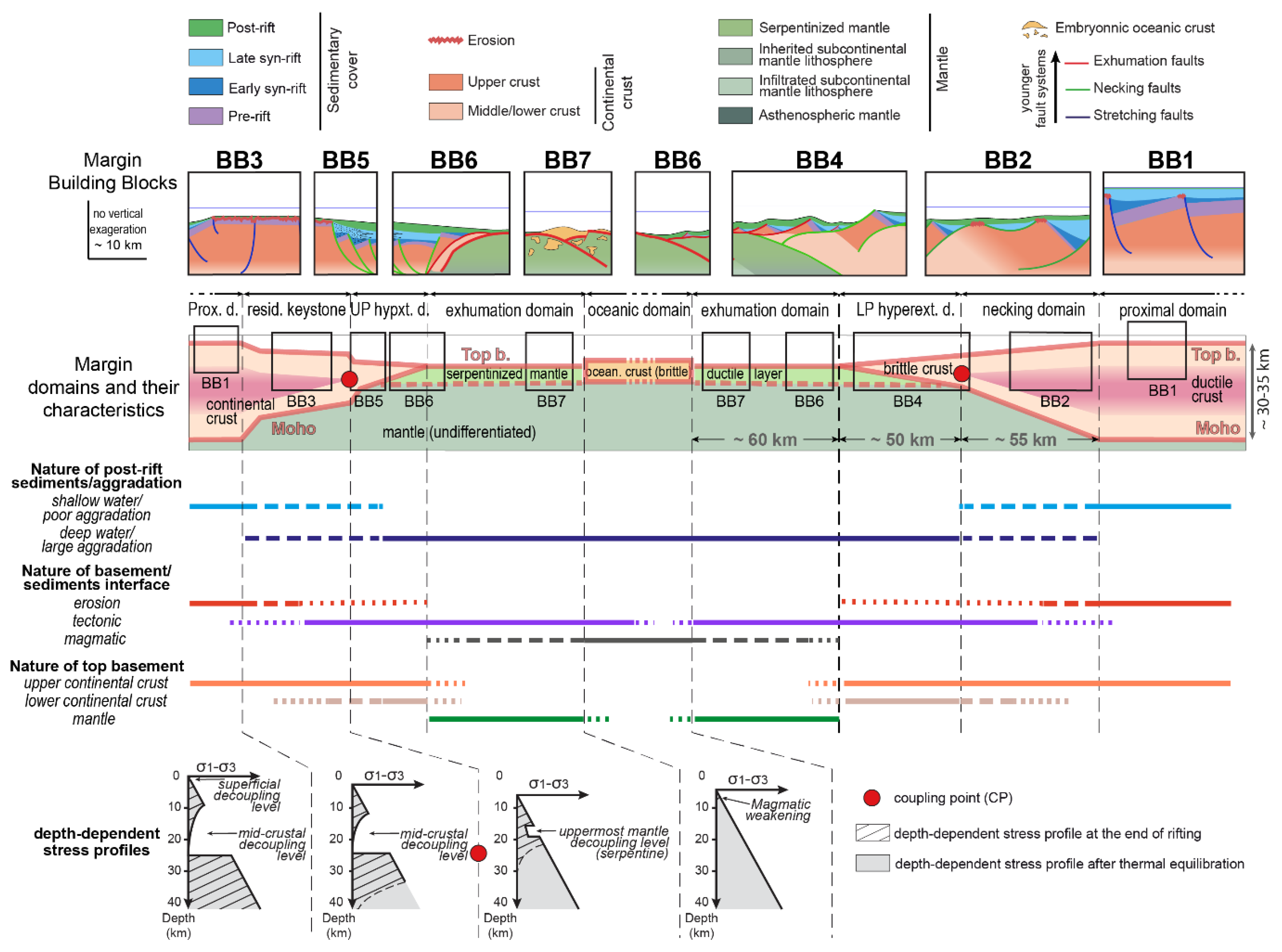
Abstract
:1. Introduction
2. Concepts and Terminology: Building Blocks vs. Rift Domains and Location and Nature of Rift-Inherited Decoupling Levels
- BB1 displays classical tilted blocks and half-graben bounded by high-angle normal faults with only limited accommodation (Figure 1). Examples of BB1 include the Bourg d’Oisans Basin in the Western Alps ([30]; (1) in Figure 2e) and the Monte Generoso Basin in the Southern Alps ([31]; (2) in Figure 2e). BB1 is the typical fingerprint of a proximal margin, where the crust is 30 ± 5 km thick. There, crustal thinning is accommodated by high-angle normal faulting in the brittle upper crust and ductile deformation in the middle/lower crust (i.e., decoupled deformation sensu [32]). Two types of decoupling levels can typically occur in the proximal domain: intra-basin decoupling levels such as evaporite and/or clay-rich layers within the sedimentary cover; and crustal decoupling levels related to weak, ductile layers within the continental crust.
- BB2 (Figure 1) displays crustal-scale shear zones juxtaposing upper- and middle/lower crustal levels and/or pluri-kilometric offset extensional detachment faults exhuming crustal basements to the seafloor. Such detachment faults are typically overlain by detrital clastic sediments reworking the underlying footwall (usually sandstones or breccias) deposited in shallow-marine environments. Examples of BB2 include the Mont Blanc in the Western Alps ([33,34]; (3) in Figure 2e), and the Eita shear zone and Grosina detachment in the Central Alps ([35]; (4) in Figure 2e). BB2 is the typical fingerprint of a necking domain (Figure 1), where the crust thins from 30 to 10 km essentially via detachment faulting [35,36]. The oceanward limit of the necking domain corresponds to the coupling point (CP, see Figure 1), where the thinned continental crust first becomes fully brittle [37]. In the proximal part of the necking domain, decoupling levels are comparable to those of the adjacent proximal domain. They progressively decrease in thickness oceanward to finally disappear at the CP.
- BB3 displays a major syn-rift unconformity (so-called “Briançonnais-type unconformity”; Figure 1; [38]) resulting from pervasive erosion/karstification. The type locality of BB3 is the Fond Froid—Lac de l’Ascension area in the Briançonnais nappes of the Western Alps ([39,40]; (5) in Figure 2e). BB3 is a typical fingerprint of a “residual keystone block”, a ribbon of moderately thinned continental crust (20 ± 5 km-thick) that is characteristic of upper-plate rifted margins [41]. The distribution of decoupling levels is comparable to that of necking domains.
- BB4 displays successive, in-sequence, long-offset extensional detachment faults responsible for the tectonic exhumation of mid- and/or lower crustal levels at the seafloor (Figure 1). A typical example of BB4 is the Err detachment system in the Central Alps ([42,43]; (6) in Figure 2e). BB4 is the classical fingerprint of the hyperextended domain of lower-plate rifted margins, where the fully brittle crust tapers from 10 to 0 km. The main decoupling level in this domain lies within the serpentinized mantle, flooring the crustal taper. Other decoupling levels may arise from detachment systems and/or low-friction layers within the sediments (e.g., [14,44]).
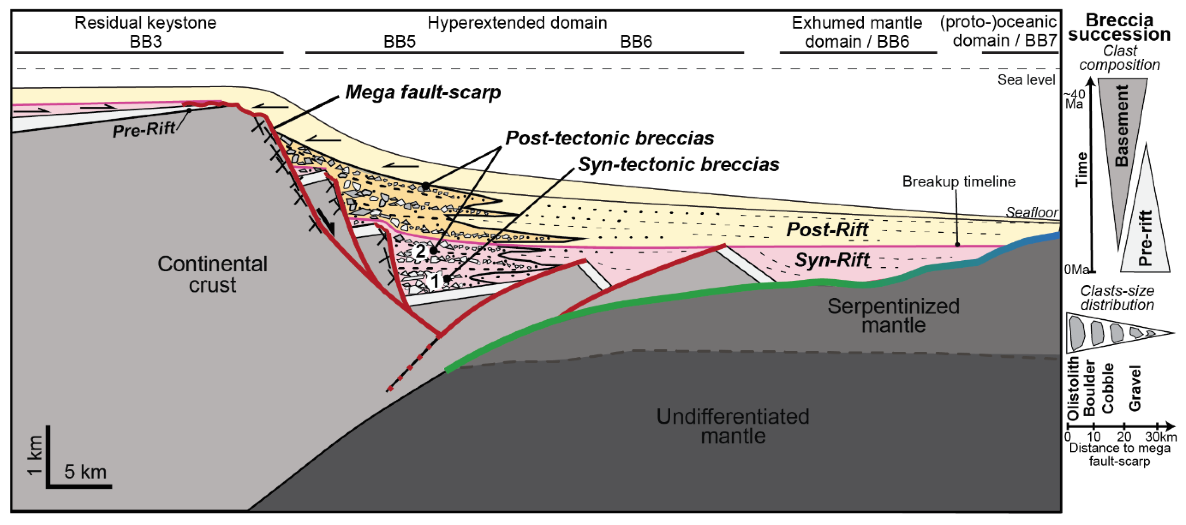
- BB5 displays major breccia bodies and is a typical fingerprint of the transition between the necking domain/residual keystone block (topographic high) and the hyperextended domain (topographic low) of upper-plate margins (Figure 1). It usually represents a significant and long-lived topographic step (mega-fault scarp sensu [45]) that is an efficient source for the mega-breccia deposited at its toe [45]. Examples of BB5 include the Breccia Nappe in the Pre-Alps ([45]; (7) in Figure 2e) and the Monte Galero Breccia in the Ligurian Alps ([46]; (8) in Figure 2e).
- BB6 displays exhumed serpentinized mantle capped by extensional detachment faults and ophicalcites, which are in turn overlain by tectono-sedimentary breccias and deep-water sediments (Figure 1). The best example of BB6 is the Tasna Nappe in the Central Alps ([47]; (9) in Figure 2e). BB6 is the typical fingerprint of an exhumed mantle domain. There, the serpentine–sediment boundary is the most prominent decoupling layer.
- BB7 displays serpentinized mantle with many syn-exhumation mafic extrusive and intrusive rock bodies. Mantle exhumation faults are often affected by later high-angle normal faulting (Figure 1). The first overlying sediments are either tectono-sedimentary breccias reworking exhumed mantle and/or mafic extrusive rocks or deep-water sediments such as radiolarian cherts. Examples of BB7 include the Lower Platta Unit in the Central Alps ([48]; (10) in Figure 2e) and the Chenaillet Ophiolite in the Western Alps ([49]; (11) in Figure 2e). BB7 is the typical fingerprint of a proto-oceanic domain. Decoupling levels lie either in the serpentinized uppermost mantle or within the overlying sediments.
3. Geological Setting
3.1. Rifting and Convergence in the Alpine Tethys Realm
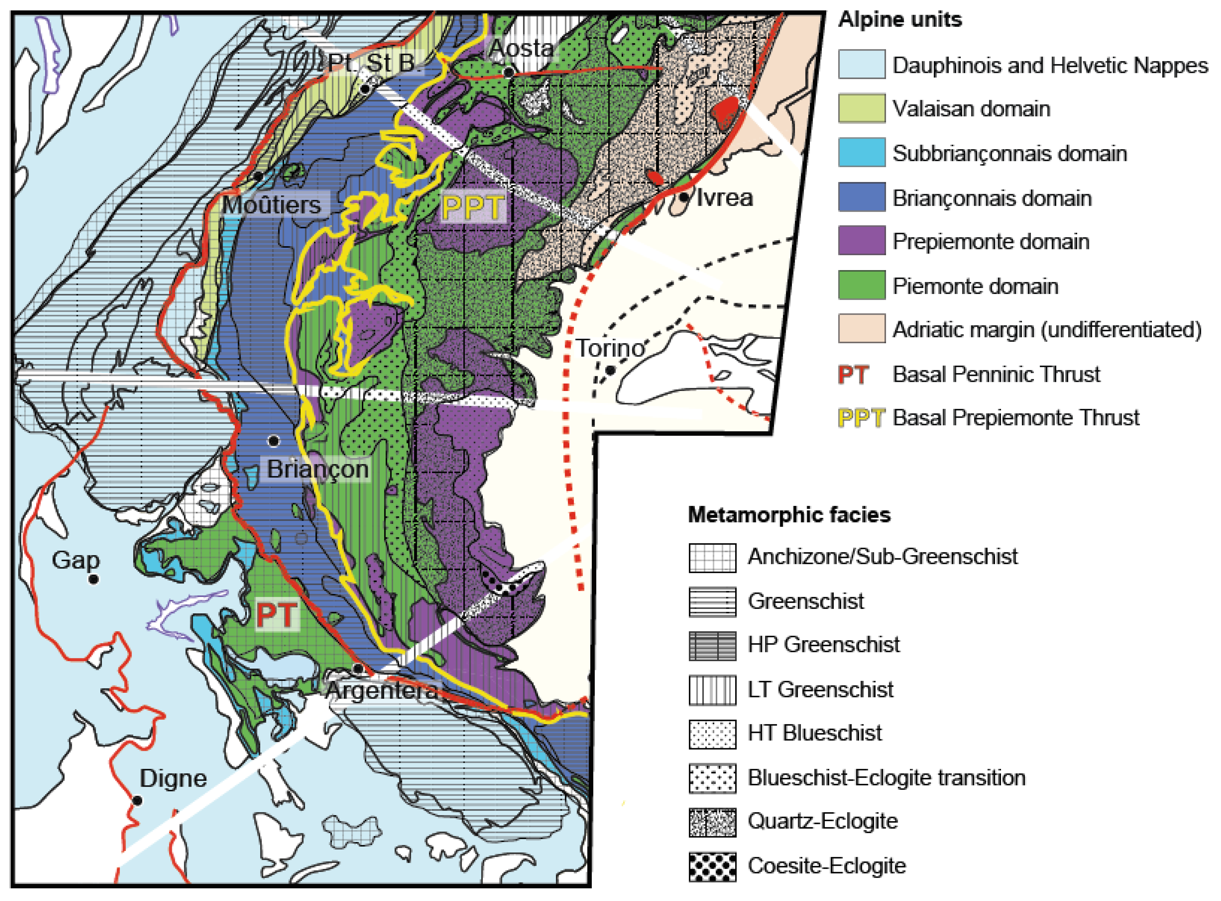
3.2. Structure of the Western Alps
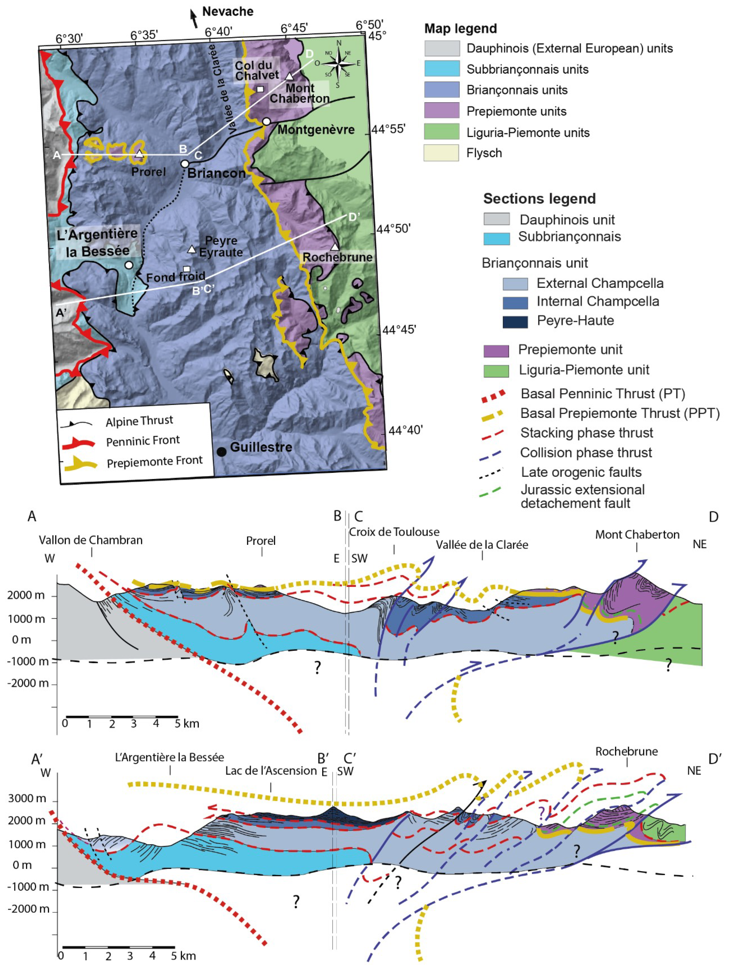
3.3. Study Area
4. Identification of BBs along a Transect across the Western Alps
4.1. The Dauphinois Units


4.1.1. The External Oisans
Rift-Related Observations

Orogen-Related Observations
4.1.2. The Internal Oisans
Rift-Related Observations
Orogen-Related Observations
4.2. The Piemonte Units
4.2.1. Rift-Related Observations
4.2.2. Orogen-Related Observations
4.3. The Subbriançonnais, Briançonnais and Prepiemonte Units
4.3.1. The Subbriançonnais Units
Rift-Related Observations
Orogen-Related Observations
4.3.2. The Briançonnais Units s. str.
Rift-Related Observations
Orogen-Related Observations
4.3.3. The Prepiemonte Units
Rift-Related Observations
Orogen-Related Observations
5. Reassessment of Rift Inheritance in the Prorel and Grand Chalvet–Rio Secco Units
5.1. New Field Observations
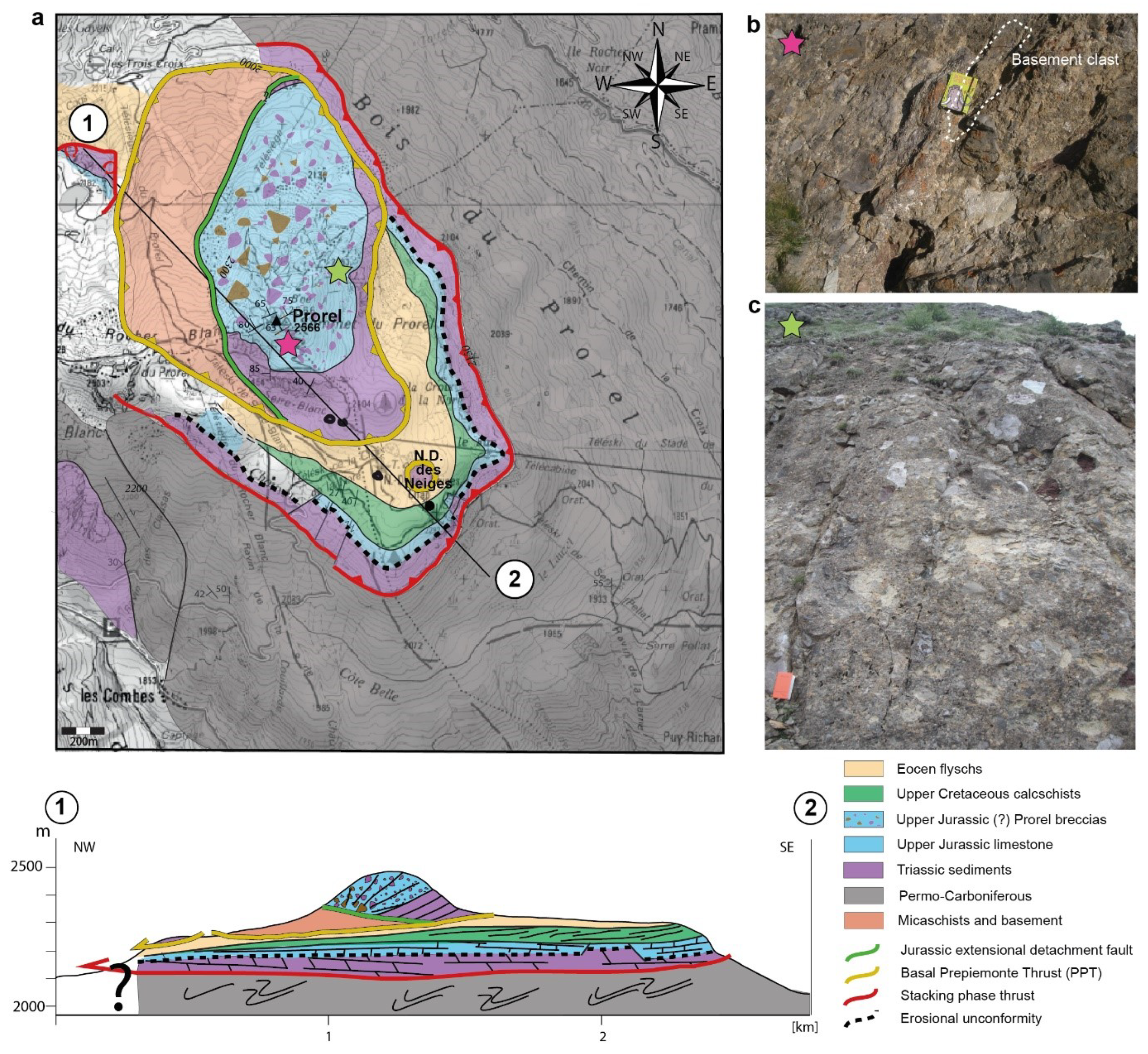
5.1.1. The Prorel Summit
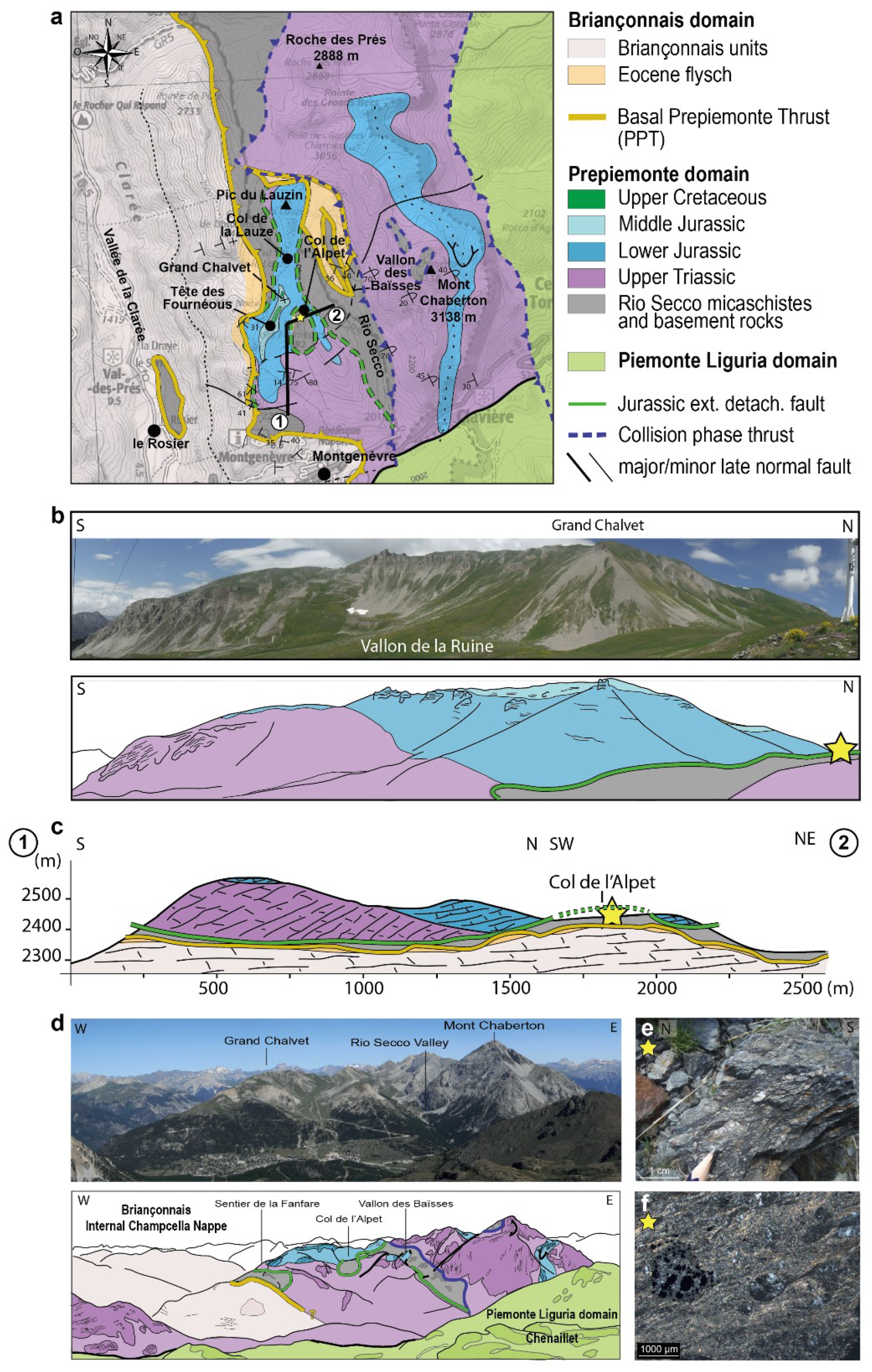
5.1.2. The Grand Chalvet—Rio Secco Section
5.2. From Outcrop Observations to Paleogeographic Interpretations
5.2.1. Criteria to Discriminate between Topographic Highs and Lows
5.2.2. Criteria to Distinguish between Erosional and Tectonic Exhumation Surfaces
5.2.3. Criteria to Discriminate between a Sharp vs. a Progressive Topographic Slope
6. The Alpine Stack and Related Major Structures in the Western Alps
6.1. The Basal Penninic Thrust (PT)
6.2. The Basal Prepiemonte Thrust (PPT)
6.3. Internal and External Limits of the (Proto-)Oceanic Piemonte Domain
7. Discussion
7.1. Determining the Rift Template of the Western Alps: Why Is It Important?
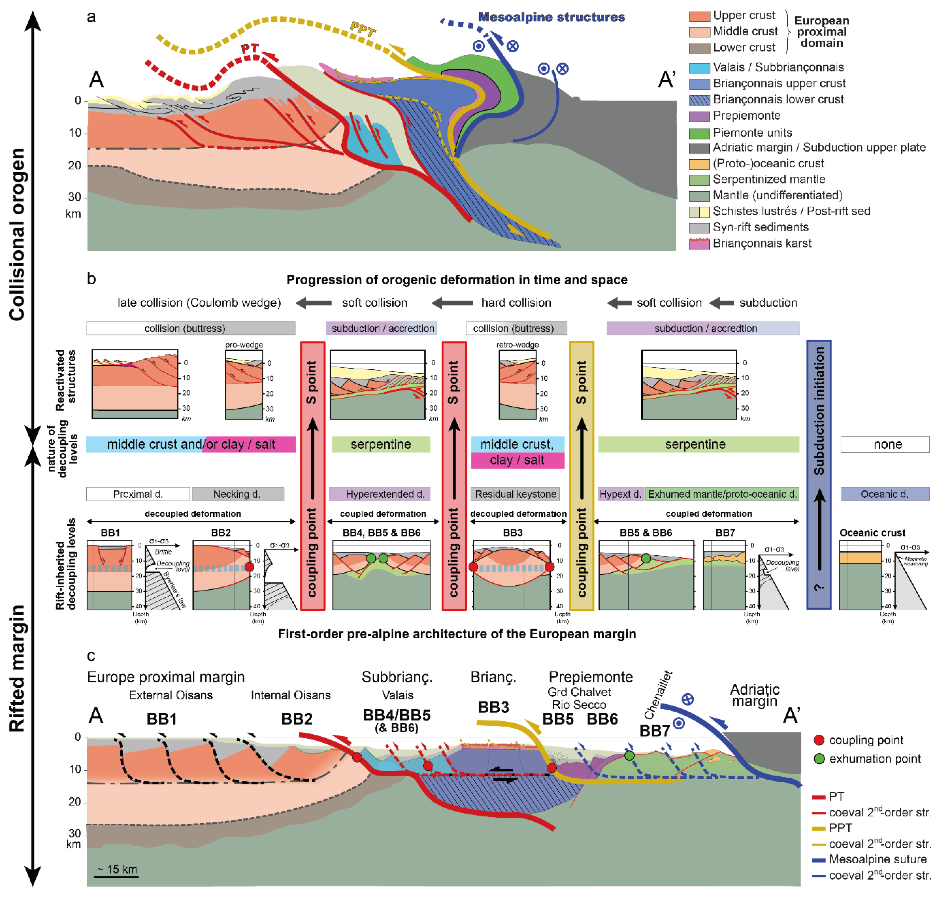
7.2. First-Order Architecture of the European–Briançonnais Margin
7.2.1. The Proximal European Margin
7.2.2. The Valais Basin
7.2.3. The Briançonnais Ribbon
7.2.4. The Hyperextended and (Proto-)Oceanic Domain of the Piemonte Basin
7.3. Rift-Inherited Structures and Decoupling Levels: Role in Controlling Reactivation
7.4. Timing of Convergence, in-Sequence Faulting, and Strain Partitioning
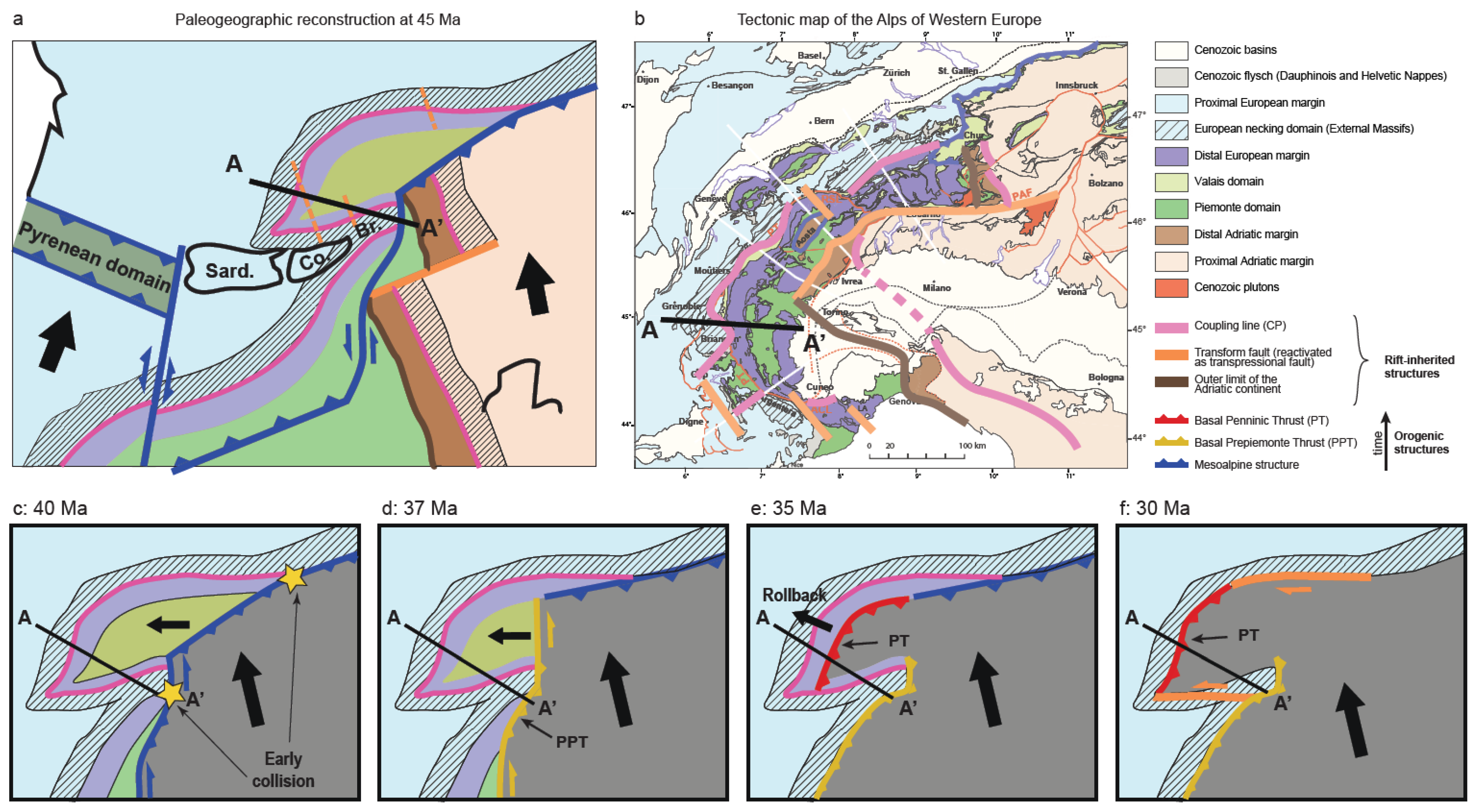
7.5. From Late Subduction to Collision in the Western Alps
7.6. The Change in Kinematics from Subduction to Early Collision: Global vs. Regional
7.7. The Three-Dimensional Distribution of Rift Coupling Points (CPs): Its Impact on the Orogenic Architecture and Evolution of the Western Alps
8. Conclusions
Author Contributions
Funding
Data Availability Statement
Acknowledgments
Conflicts of Interest
References
- Butler, R.W.H. Thrust sequences. J. Geol. Soc. 1987, 144, 619–634. [Google Scholar] [CrossRef]
- Butler, R.W.H. The influence of pre-existing basin structure on thrust system evolution in the Western Alps. Geol. Soc. Lond. Spec. Publ. 1989, 44, 105–122. [Google Scholar] [CrossRef]
- Butler, R.W.H.H. Area balancing as a test of models for the deep structure of mountain belts, with specific reference to the Alps. J. Struct. Geol. 2013, 52, 2–16. [Google Scholar] [CrossRef]
- Butler, R.W.H.; Tavarnelli, E.; Grasso, M. Structural inheritance in mountain belts: An Alpine-Apennine perspective. J. Struct. Geol. 2006, 28, 1893–1908. [Google Scholar] [CrossRef]
- Chenin, P.; Manatschal, G.; Picazo, S.; Müntener, O.; Karner, G.D.; Johnson, C.; Ulrich, M. Influence of the architecture of magma-poor hyperextended rifted margins on orogens produced by the closure of narrow versus wide oceans. Geosphere 2017, 13, 559–576. [Google Scholar] [CrossRef] [Green Version]
- Coward, M.P.; Gillcrist, R.; Trudgill, B. Extensional structures and their tectonic inversion in the Western Alps. Geol. Soc. Spec. Publ. 1991, 56, 93–112. [Google Scholar] [CrossRef]
- De Graciansky, P.C.; Dardeau, G.; Lemoine, M.; Tricart, P. The inverted margin of the French Alps and foreland basin inversion. Geol. Soc. Lond. Spec. Publ. 1989, 44, 87–104. [Google Scholar] [CrossRef]
- Epin, M.E.; Manatschal, G.; Amann, M. Defining diagnostic criteria to describe the role of rift inheritance in collisional orogens: The case of the Err-Platta nappes (Switzerland). Swiss J. Geosci. 2017, 110, 419–438. [Google Scholar] [CrossRef]
- Gómez-Romeu, J.; Masini, E.; Tugend, J.; Ducoux, M.; Kusznir, N. Role of rift structural inheritance in orogeny highlighted by the Western Pyrenees case-study. Tectonophysics 2019, 766, 131–150. [Google Scholar] [CrossRef]
- Lemoine, M.; Trümpy, R. Pre-oceanic rifting in the alps. Tectonophysics 1987, 133, 305–320. [Google Scholar] [CrossRef]
- Lescoutre, R.; Manatschal, G. Role of rift-inheritance and segmentation for orogenic evolution: Example from the Pyrenean-Cantabrian system. Bull. la Soc. Geol. Fr. 2020, 191, 18. [Google Scholar] [CrossRef]
- Manatschal, G.; Chenin, P.; Lescoutre, R.; Miró, J.; Cadenas, P.; Saspiturry, N.; Masini, E.; Chevrot, S.; Ford, M.; Jolivet, L.; et al. The role of inheritance in forming rifts and rifted margins and building collisional orogens: A Biscay-Pyrenean perspective. Bull. Soc. Géol. Fr. 2021, 192, 55. [Google Scholar] [CrossRef]
- McCarthy, A.; Tugend, J.; Mohn, G. Formation of the Alpine Orogen by Amagmatic Convergence and Assembly of Previously Rifted Lithosphere. Elements 2021, 17, 29–34. [Google Scholar] [CrossRef]
- Miró, J.; Cadenas, P.; Manatschal, G.; Munoz, J.A. Reactivation of a hyperextended rift system: The Basque-Cantabrian Pyrenees case. Basin Res. 2021, 33, 3077–3101. [Google Scholar] [CrossRef]
- Mohn, G.; Manatschal, G.; Beltrando, M.; Haupert, I. The role of rift-inherited hyper-extension in Alpine-type orogens. Terra Nova 2014, 26, 347–353. [Google Scholar] [CrossRef]
- Schmid, S.M.; Fgenschuh, B.; Kissling, E.; Schuster, R.; Fügenschuh, B. Tectonic map and overall architecture of the Alpine orogen. Eclogae Geol. Helv. 2004, 97, 93–117. [Google Scholar] [CrossRef]
- Tavani, S.; Granado, P.; Corradetti, A.; Camanni, G.; Vignaroli, G.; Manatschal, G.; Mazzoli, S.; Muñoz, J.A.; Parente, M. Rift inheritance controls the switch from thin- to thick-skinned thrusting and basal décollement re-localization at the subduction-to-collision transition. GSA Bull. 2021, 133, 2157–2170. [Google Scholar] [CrossRef]
- Tugend, J.; Manatschal, G.; Kusznir, N.J.; Masini, E.; Mohn, G.; Thinon, I. Formation and deformation of hyperextended rift systems: Insights from rift domain mapping in the Bay of Biscay-Pyrenees. Tectonics 2014, 33, 1239–1276. [Google Scholar] [CrossRef]
- Manatschal, G.; Chenin, P.; Ghienne, J.-F.; Ribes, C.; Masini, E. The syn-rift tectono-stratigraphic record of rifted margins (Part I): Insights from the Alpine Tethys. Basin Res. 2022, 34, 457–488. [Google Scholar] [CrossRef]
- McCarthy, A.; Tugend, J.; Mohn, G.; Candioti, L.; Chelle-Michou, C.; Arculus, R.; Schmalholz, S.M.; Müntener, O. A case of Ampferer-type subduction and consequences for the Alps and the Pyrenees. Am. J. Sci. 2020, 320, 313–372. [Google Scholar] [CrossRef]
- Angrand, P.; Mouthereau, F.; Masini, E.; Asti, R. A reconstruction of Iberia accounting for Western Tethys-North Atlantic kinematics since the late-Permian-Triassic. Solid Earth 2020, 11, 1313–1332. [Google Scholar] [CrossRef]
- Handy, M.R.; Schmid, S.; Bousquet, R.; Kissling, E.; Bernoulli, D. Reconciling plate-tectonic reconstructions of Alpine Tethys with the geological-geophysical record of spreading and subduction in the Alps. Earth-Sci. Rev. 2010, 102, 121–158. [Google Scholar] [CrossRef]
- Rosenbaum, G.; Lister, G.S.; Duboz, C. Relative motions of Africa, Iberia and Europe during Alpine orogeny. Tectonophysics 2002, 359, 117–129. [Google Scholar] [CrossRef]
- Schmid, S.M.; Kissling, E.; Diehl, T.; van Hinsbergen, D.J.J.; Molli, G. Ivrea mantle wedge, arc of the Western Alps, and kinematic evolution of the Alps–Apennines orogenic system. Swiss J. Geosci. 2017, 110, 581–612. [Google Scholar] [CrossRef]
- Macchiavelli, C.; Vergés, J.; Schettino, A.; Fernàndez, M.; Turco, E.; Casciello, E.; Torne, M.; Pierantoni, P.P.; Tunini, L. A new southern North Atlantic isochron map: Insights into the drift of the Iberian plate since the Late Cretaceous. J. Geophys. Res. Solid Earth 2017, 122, 9603–9626. [Google Scholar] [CrossRef] [Green Version]
- Vissers, R.L.M.; Meijer, P.T. Iberian plate kinematics and Alpine collision in the Pyrenees. Earth-Sci. Rev. 2012, 114, 61–83. [Google Scholar] [CrossRef]
- Chopin, C. Very-high-pressure metamorphism in the Western Alps: Implications for subduction of continental crust [and discussion]. Philos. Trans. R. Soc. A Math. Phys. Eng. Sci. 1987, 321, 183–197. [Google Scholar] [CrossRef]
- Lardeaux, J.M. Deciphering orogeny: A metamorphic perspective. Examples from European Alpine and Variscan beltsPart I: Alpine metamorphism in the western Alps. A review. Bull. Soc. Géol. Fr. 2014, 185, 93–114. [Google Scholar] [CrossRef]
- Boillot, G.; Capdevila, R. The Pyrenees: Subduction and collision? Earth Planet. Sci. Lett. 1977, 35, 151–160. [Google Scholar] [CrossRef]
- Lemoine, M.; Gidon, M.; Barféty, J.C. Les massifs cristallins externes des Alpes occidentales: d’anciens blocs basculés nés au Lias lors du rifting téthysien. C. R. Acad. Sc. Paris 1981, 292, 917–920. [Google Scholar]
- Bertotti, G.; Picotti, V.; Bernoulli, D.; Castellarin, A. From rifting to drifting: Tectonic evolution of the South-Alpine upper crust from the Triassic to the Early Cretaceous. Sediment. Geol. 1993, 86, 53–76. [Google Scholar] [CrossRef]
- Sutra, E.; Manatschal, G.; Mohn, G.; Unternehr, P. Quantification and restoration of extensional deformation along the Western Iberia and Newfoundland rifted margins. Geochem. Geophys. Geosyst. 2013, 14, 2575–2597. [Google Scholar] [CrossRef]
- Dall’Asta, N.; Hoareau, G.; Manatschal, G.; Centrella, S.; Denèle, Y.; Ribes, C.; Kalifi, A. Structural and petrological characteristics of a Jurassic detachment fault from the Mont-Blanc massif (Col du Bonhomme area, France). J. Struct. Geol. 2022, 159, 104593. [Google Scholar] [CrossRef]
- Ribes, C.; Ghienne, J.F.; Manatschal, G.; Dall’Asta, N.; Stockli, D.F.; Galster, F.; Gillard, M.; Karner, G.D. The Grès Singuliers of the Mont Blanc region (France and Switzerland): Stratigraphic response to rifting and crustal necking in the Alpine Tethys. Int. J. Earth Sci. 2020, 109, 2325–2352. [Google Scholar] [CrossRef]
- Mohn, G.; Manatschal, G.; Beltrando, M.; Masini, E.; Kusznir, N. Necking of continental crust in magma-poor rifted margins: Evidence from the fossil Alpine Tethys margins. Tectonics 2012, 31, TC1012. [Google Scholar] [CrossRef]
- Osmundsen, P.T.; Péron-Pinvidic, G. Crustal-scale fault interaction at rifted margins and the formation of domain-bounding breakaway complexes: Insights from offshore Norway. Tectonics 2018, 37, 935–964. [Google Scholar] [CrossRef]
- Sutra, E.; Manatschal, G. How does the continental crust thin in a hyperextended rifted margin? Insights from the Iberia margin. Geology 2012, 40, 139–142. [Google Scholar] [CrossRef]
- Chenin, P.; Manatschal, G.; Decarlis, A.; Schmalholz, S.M.; Duretz, T.; Beltrando, M. Emersion of distal domains in advanced stages of continental rifting explained by asynchronous crust and mantle necking. Geochem. Geophys. Geosyst. 2019, 20, 3821–3840. [Google Scholar] [CrossRef] [Green Version]
- Barféty, J.C. Etude Géologique des Environs du Monétier-les-Bains (H-A) (Zones Subbriançonnaise et Briançonnaise)—Alpes Françaises; Université de Grenoble: Saint-Martin-d’Hères, France, 1965. [Google Scholar]
- Baud, A.; Megard-Galli, J. Evolution d’un bassin carbonaté du domaine alpin durant la phase pré-océanique: Cycles et séquences dans le Trias de la zone briançonnaise des Alpes occidentales et des Préalpes. In Proceedings of the IXe Congrès International de Sédimentologie, Nice, France, 13–15 July 1975; pp. 45–51. [Google Scholar]
- Haupert, I.; Manatschal, G.; Decarlis, A.; Unternehr, P. Upper-plate magma-poor rifted margins: Stratigraphic architecture and structural evolution. Mar. Pet. Geol. 2016, 69, 241–261. [Google Scholar] [CrossRef] [Green Version]
- Epin, M.E.; Manatschal, G. Three-dimensional architecture, structural evolution, and role of inheritance controlling detachment faulting at a hyperextended distal margin: The example of the Err detachment system (SE Switzerland). Tectonics 2018, 37, 4494–4514. [Google Scholar] [CrossRef]
- Masini, E.; Manatschal, G.; Mohn, G.; Unternehr, P. Anatomy and tectono-sedimentary evolution of a rift-related detachment system: The example of the Err detachment (central Alps, SE Switzerland). Bull. Geol. Soc. Am. 2012, 124, 1535–1551. [Google Scholar] [CrossRef]
- Ducoux, M.; Jolivet, L.; Cagnard, F.; Baudin, T. Basement-Cover Decoupling During the Inversion of a Hyperextended Basin: Insights From the Eastern Pyrenees. Tectonics 2021, 40, e2020TC006512. [Google Scholar] [CrossRef]
- Ribes, C.; Ghienne, J.-F.; Manatschal, G.; Decarlis, A.; Karner, G.D.; Figueredo, P.H.; Johnson, C.A. Long-lived mega fault-scarps and related breccias at distal rifted margins: Insights from present-day and fossil analogues. J. Geol. Soc. Lond. 2019, 176, 801–816. [Google Scholar] [CrossRef]
- Decarlis, A.; Manatschal, G.; Haupert, I.; Masini, E. The tectono-stratigraphic evolution of distal, hyper-extended magma-poor conjugate rifted margins: Examples from the Alpine Tethys and Newfoundland–Iberia. Mar. Pet. Geol. 2015, 68, 54–72. [Google Scholar] [CrossRef]
- Ribes, C.; Petri, B.; Ghienne, J.; Manatschal, G.; Galster, F.; Karner, G.D.; Figueredo, P.H.; Johnson, C.A.; Karpoff, A. Tectono-sedimentary evolution of a fossil ocean-continent transition: Tasna nappe, central Alps (SE Switzerland). Geol. Soc. Am. Bull. 2019, 132, 1427–1446. [Google Scholar] [CrossRef]
- Epin, M.-E.; Manatschal, G.; Amann, M.; Ribes, C.; Clausse, A.; Guffon, T.; Lescanne, M. Polyphase tectono-magmatic evolution during mantle exhumation in an ultra-distal, magma-poor rift domain: Example of the fossil Platta ophiolite, SE Switzerland. Int. J. Earth Sci. 2019, 108, 2443–2467. [Google Scholar] [CrossRef]
- Manatschal, G.; Sauter, D.; Karpoff, A.M.; Masini, E.; Mohn, G.; Lagabrielle, Y. The Chenaillet Ophiolite in the French/Italian Alps: An ancient analogue for an Oceanic Core Complex? Lithos 2011, 124, 169–184. [Google Scholar] [CrossRef]
- Frasca, G.; Manatschal, G.; Cadenas, P.; Miró, J.; Lescoutre, R. A kinematic reconstruction of Iberia using intracontinental strike-slip corridors. Terra Nova 2021, 33, 573–581. [Google Scholar] [CrossRef]
- Hosseinpour, M.; Williams, S.; Seton, M.; Barnett-Moore, N.; Müller, R.D. Tectonic evolution of Western Tethys from Jurassic to present day: Coupling geological and geophysical data with seismic tomography models. Int. Geol. Rev. 2016, 58, 1616–1645. [Google Scholar] [CrossRef] [Green Version]
- Le Breton, E.; Brune, S.; Ustaszewski, K.; Zahirovic, S.; Seton, M.; Müller, R.D. Kinematics and extent of the Piemont-Liguria Basin—implications for subduction processes in the Alps. Solid Earth 2021, 12, 885–913. [Google Scholar] [CrossRef]
- Anders, B.; Reischmann, T.; Kostopoulos, D. Zircon geochronology of basement rocks from the Pelagonian Zone, Greece: Constraints on the pre-Alpine evolution of the westernmost Internal Hellenides. Int. J. Earth Sci. 2007, 96, 639–661. [Google Scholar] [CrossRef]
- Baumgartner, P.O. Mesozoic radiolarites—accumulation as a function of sea surface fertility on Tethyan margins and in ocean basins. Sedimentology 2013, 60, 292–318. [Google Scholar] [CrossRef]
- Péron-Pinvidic, G.; Manatschal, G. From microcontinents to extensional allochthons: Witnesses of how continents rift and break apart? Pet. Geosci. 2010, 16, 189–197. [Google Scholar] [CrossRef]
- Hunziker, J.C.; Desmons, J.; Hurford, A.J. Thirty-Two Years of Geochronological Work in the Central and Western Alps: A Review on Seven Maps. In Mémoires de Géologie (Lausanne) n°13; Université de Lausanne: Lausanne, Switzerland, 1992. [Google Scholar]
- Dumont, T.; Schwartz, S.; Guillot, S.; Malusà, M.; Jouvent, M.; Monié, P.; Verly, A. Cross-propagation of the western Alpine orogen from early to late deformation stages: Evidence from the Internal Zones and implications for restoration. Earth-Sci. Rev. 2022, 232, 104106. [Google Scholar] [CrossRef]
- Kley, J.; Voigt, T. Late Cretaceous intraplate thrusting in Central Europe: Effect of Africa-Iberia-Europe convergence, not Alpine collision. Geology 2008, 36, 839–842. [Google Scholar] [CrossRef]
- Schettino, A.; Turco, E. Tectonic history of the western Tethys since the Late Triassic. GSA Bull. 2011, 123, 89–105. [Google Scholar] [CrossRef]
- Pfiffner, O.A.; Schlunegger, F.; Buiter, S.J.H. The Swiss Alps and their peripheral foreland basin: Stratigraphic response to deep crustal processes. Tectonics 2002, 21, 3-1–3-16. [Google Scholar] [CrossRef] [Green Version]
- Schmid, S.M.; Pfiffner, O.A.; Froitzheim, N.; Schönborn, G.; Kissling, E. Geophysical-geological transect and tectonic evolution of the Swiss-Italian Alps. Tectonics 1996, 15, 1036–1064. [Google Scholar] [CrossRef] [Green Version]
- Herviou, C.; Agard, P.; Plunder, A.; Mendes, K.; Verlaguet, A.; Deldicque, D.; Cubas, N. Subducted fragments of the Liguro-Piemont ocean, Western Alps: Spatial correlations and offscraping mechanisms during subduction. Tectonophysics 2022, 827, 229267. [Google Scholar] [CrossRef]
- Pognante, U.; Perotto, A.; Salino, C.; Toscani, L. The ophiolitic peridotites of the Western Alps: Record of the evolution of a small oceanic-type basin in the Mesozoic Tethys. TMPM Tschermaks Mineral. Und Petrogr. Mitt. 1986, 35, 47–65. [Google Scholar] [CrossRef]
- Jolivet, L.; Baudin, T.; Calassou, S.; Chevrot, S.; Ford, M.; Issautier, B.; Lasseur, E.; Masini, E.; Manatschal, G.; Mouthereau, F.; et al. Geodynamic evolution of a wide plate boundary in the Western Mediterranean, near-field versus far-field interactions. Bull. Soc. Géol. Fr. 2021, 192, 48. [Google Scholar] [CrossRef]
- Fox, M.; Herman, F.; Kissling, E.; Willett, S.D. Rapid exhumation in the Western Alps driven by slab detachment and glacial erosion. Geology 2015, 43, 379–382. [Google Scholar] [CrossRef] [Green Version]
- Beltrando, M.; Lister, G.S.; Rosenbaum, G.; Richards, S.; Forster, M.A. Recognizing episodic lithospheric thinning along a convergent plate margin: The example of the Early Oligocene Alps. Earth-Sci. Rev. 2010, 103, 81–98. [Google Scholar] [CrossRef]
- Rubatto, D.; Hermann, J. Exhumation as fast as subduction? Geology 2001, 29, 3–6. [Google Scholar] [CrossRef]
- von Blanckenburg, F.; Davies, J.H. Slab breakoff: A model for syncollisional magmatism and tectonics in the Alps. Tectonics 1995, 14, 120–131. [Google Scholar] [CrossRef]
- Ricou, L.E.; Siddans, A.W.B. Collision tectonics in the Western Alps. Geol. Soc. Spec. Publ. 1986, 19, 229–244. [Google Scholar] [CrossRef]
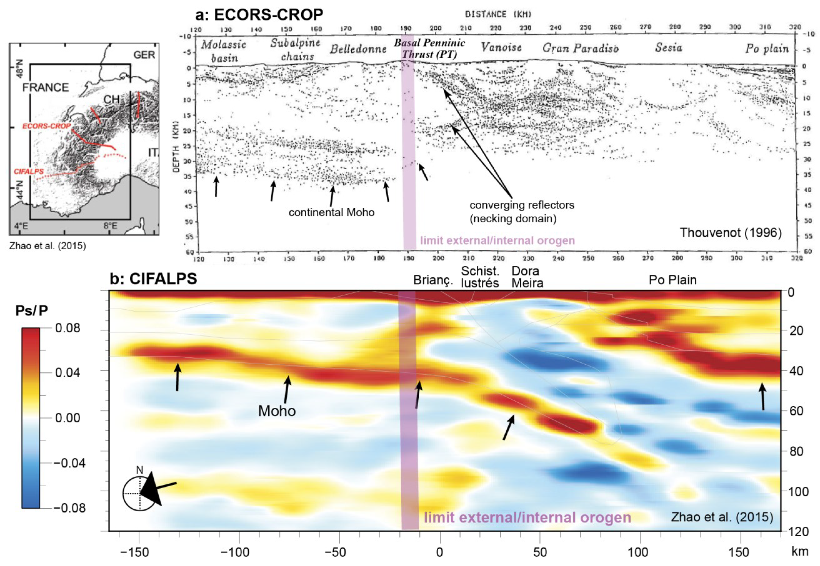
- Malusà, M.G.; Guillot, S.; Zhao, L.; Paul, A.; Solarino, S.; Dumont, T.; Schwartz, S.; Aubert, C.; Baccheschi, P.; Eva, E.; et al. The Deep Structure of the Alps Based on the CIFALPS Seismic Experiment: A Synthesis. Geochem. Geophys. Geosyst. 2021, 22, e2020GC009466. [Google Scholar] [CrossRef]
- De Graciansky, P.C.; Roberts, D.G.; Tricart, P. The Western Alps, from Rift to Passive Margin to Orogenic Belt: An Integrated Geoscience Overview, Developments in Earth Surface Processes; Elsevier: Amsterdam, The Netherlands; Oxford, UK, 2011. [Google Scholar]
- Lemoine, M.; Bas, T.; Arnaud-Vanneau, A.; Arnaud, H.; Dumont, T.; Gidon, M.; Bourbon, M.; de Graciansky, P.C.; Rudkiewicz, J.L.; Megard-Galli, J.; et al. The continental margin of the Mesozoic Tethys in the Western Alps. Mar. Pet. Geol. 1986, 3, 179–199. [Google Scholar] [CrossRef]
- Thouvenot, F.; Senechal, G.; Truffert, C.; Guellec, S. Comparison between two techniques of line-drawing migration (ray tracing and common tangent method). Mere. Soc. Geol. Fr. 1996, 170, 53–59. [Google Scholar]
- Zhao, L.; Zheng, T.; Zhu, R.; Wang, Q.; Paul, A.; Guillot, S.; Aubert, C.; Dumont, T.; Schwartz, S.; Solarino, S.; et al. First seismic evidence for continental subduction beneath the Western Alps. Geology 2015, 43, 815–818. [Google Scholar] [CrossRef] [Green Version]
- Boutoux, A.; Bellahsen, N.; Lacombe, O.; Verlaguet, A.; Mouthereau, F. Inversion of pre-orogenic extensional basins in the external Western Alps: Structure, microstructures and restoration. J. Struct. Geol. 2014, 60, 13–29. [Google Scholar] [CrossRef]
- Dumont, T.; Champagnac, J.D.; Crouzet, C.; Rochat, P. Multistage shortening in the Dauphiné zone (French Alps): The record of Alpine collision and implications for pre-Alpine restoration. Swiss J. Geosci. 2008, 101, 89–110. [Google Scholar] [CrossRef]
- Dumont, T.; Simon-Labric, T.; Authemayou, C.; Heymes, T. Lateral termination of the north-directed Alpine orogeny and onset of westward escape in the Western Alpine arc: Structural and sedimentary evidence from the external zone. Tectonics 2011, 30, TC5006. [Google Scholar] [CrossRef] [Green Version]
- Gillcrist, R.; Coward, M.; Mugnier, J.L. Structural inversion and its controls: Examples from the Alpine foreland and the French Alps. Geodin. Acta 1987, 1, 5–34. [Google Scholar] [CrossRef]
- Dumont, T. Late Triassic-early Jurassic evolution of the western Alps and of their European foreland-Initiation of the Late Triassic-early Jurassic evolution of the western Alps and of their European foreland; initiation of the Tethyan rifting. Bull. Soc. Géol. Fr. 1988, 4, 601–611. [Google Scholar] [CrossRef]
- Chevalier, F. Vitesse et Cyclicité de Fonctionnement des Failles Normales de Rift: Implication sur le Remplissage Stratigraphique des Bassins et sur les Modalités D’extension D’une Marge Passive Fossile: Aplication au Demi-Graben Liasique de Bourg D’oisans (Alpes Occidentales, France). Ph.D. Thesis, Université de Bourgogne, Dijon, France, 2002. [Google Scholar]
- Bayer, R.; Cazes, M.; Dalpiaz, G.V.; Damotte, B.; Elter, G.; Gosso, G.; Villien, A. 1st results of a deep seismic profile through the Western Alps (ECORS-CROP program). Comptes Rendus L’academie Sci. Ser. II 1987, 305, 1461–1470. [Google Scholar]
- Bellahsen, N.; Jolivet, L.; Lacombe, O.; Bellanger, M.; Boutoux, A.; Garcia, S.; Mouthereau, F.; LePourhiet, L.; Gumiaux, G. Mechanisms of margin inversion in the external Western Alps: Implications for crustal rheology. Tectonophysics 2012, 560, 62–83. [Google Scholar] [CrossRef] [Green Version]
- Bellahsen, N.; Mouthereau, F.; Boutoux, A.; Bellanger, M.; Lacombe, O.; Jolivet, L.; Rolland, Y. Collision kinematics in the western external Alps. Tectonics 2014, 33, 1055–1088. [Google Scholar] [CrossRef] [Green Version]
- Boussac, J. Etudes Stratigraphiques Sur le Nummulitique Alpin; Imprimerie Nationale: Paris, France, 1912. [Google Scholar]
- Michard, A.; Martinotti, G. The Eocene unconformity of theBriançonnais domain in the French—Italian Alps, revisited (Marguareis massif, Cuneo); a hint for aLate Cretaceous—Middle Eocene frontal bulge setting. Geodin. Acta 2002, 15, 289–301. [Google Scholar] [CrossRef] [Green Version]
- Crouzet, C.; Ménard, G.; Rochette, P. Cooling history of the Dauphinoise Zone (Western Alps, France) deduced from the thermopaleomagnetic record: Geodynamic implications. Tectonophysics 2001, 340, 79–93. [Google Scholar] [CrossRef]
- Gillcrist, J.R. Mesozoic Basin Development and Structural Inversion in the External Franch Alps. Ph.D. Thesis, Imperial College London, London, UK, 1988. [Google Scholar]
- Bouillin, J.P.; Pecher, A.; Rolland, Y.; Carrio, E.; Dumont, T.; Tricart, P. Les filons sédimentaires jurassiques du Pelvoux, enregistreurs des déformations alpines de la bordure orientale du massif cristallin externe de l’Oisans (Alpes occidentales). Comptes Rendus L’académie Sciences. Série 2. Sci. Terre Planètes 1997, 324, 409–415. [Google Scholar]
- Wibberley, C. Are feldspar-to-mica reactions necessarily reaction-softening processes in fault zones? J. Struct. Geol. 1999, 21, 1219–1227. [Google Scholar] [CrossRef]
- Gidon, M. Le rôle des étapes successives de déformation dans la tectonique alpine du massif du Pelvoux (Alpes occidentales). Comptes-Rendus L’acad Mie Des Sci. Paris 1979, 288, 803–806. [Google Scholar]
- Simon-Labric, T.; Rolland, Y.; Dumont, T.; Heymes, T.; Authemayou, C.; Corsini, M.; Fornari, M. 40Ar/ 39Ar dating of Penninic Front tectonic displacement (W Alps) during the Lower Oligocene (31–34 Ma). Terra Nova 2009, 21, 127–136. [Google Scholar] [CrossRef]
- Kerckhove, C. La “zone du Flysch” dans les nappes de l’Embrunais-Ubaye (Alpes occidentales). Géologie Alp. 1969, 45, 5–204. [Google Scholar]
- Lagabrielle, Y.; Vitale Brovarone, A.; Ildefonse, B. Fossil oceanic core complexes recognized in the blueschist metaophiolites of Western Alps and Corsica. Earth-Sci. Rev. 2015, 141, 1–26. [Google Scholar] [CrossRef]
- Loprieno, A.; Ellero, A. Geology of the Piemonte-Ligurian units of the Urtier area (Northwestern Alps–Italy). J. Maps 2021, 17, 778–791. [Google Scholar] [CrossRef]
- Pognante, U. Petrological constraints on the eclogite- and blueschist facies metamorphism and P-T-t paths in the Western Alps. J. Metamorph. Geol. 1991, 9, 5–17. [Google Scholar] [CrossRef]
- Lemoine, M.; Tricart, P. Queyras, un Océan il y a 150 Millions d’années: Initiation à la Géologie sur les Sentiers du Queyras; Parc naturel régional du Queyras: Orléans, France, 1988. [Google Scholar]
- Mével, C. Les “Pillow-Lavas” Spilitiques des Massifs Ophiolitiques du Chenaillet et des Gets (Alpes françaises). Structures et Minéraux Magmatiques Reliques, Étude Chimique et Zonations Comparaison Avec les “Pillow-Lavas” Métamorphisés du Queyras et de Hte Ubay; Université Pierre et Marie Curie-Paris VI: Paris, France, 1975. [Google Scholar]
- Tricart, P.; Lemoine, M. The Queyras ophiolite West of Monte Viso (Western Alps): Indicator of a pecular ocean floor in the mesozoic tethys. J. Geodyn. 1991, 13, 163–181. [Google Scholar] [CrossRef]
- Li, X.-H.H.; Faure, M.; Lin, W.; Manatschal, G. New isotopic constraints on age and magma genesis of an embryonic oceanic crust: The Chenaillet Ophiolite in the Western Alps. Lithos 2013, 160–161, 283–291. [Google Scholar] [CrossRef] [Green Version]
- Manatschal, G.; Müntener, O. A type sequence across an ancient magma-poor ocean—Continent transition: The example of the western Alpine Tethys ophiolites. Tectonophysics 2009, 473, 4–19. [Google Scholar] [CrossRef]
- Picazo, S.; Müntener, O.; Manatschal, G.; Bauville, A.; Karner, G.D.; Johnson, C. Mapping the nature of mantle domains in Western and Central Europe based on clinopyroxene and spinel chemistry: Evidence for mantle modification during an extensional cycle. Lithos 2016, 266–267, 233–263. [Google Scholar] [CrossRef]
- Cordey, F.; Bailly, A. Alpine ocean seafloor spreading and onset of pelagic sedimentation: New radiolarian data from the Chenaillet-Montgenèvre ophiolite (French-Italian Alps). Geodin. Acta 2007, 20, 131–138. [Google Scholar] [CrossRef] [Green Version]
- Lemoine, M. Schistes lustrés from Corsica to Hungary: Back to the original sediments and tentative dating of partly azoic metasediments. Bull. Soc. Géol. Fr. 2003, 174, 197–209. [Google Scholar] [CrossRef]
- Lemoine, M.; Tricart, P. Les Schistes lustrés piémontais des Alpes occidentales: Approche stratigraphique, structurale et sédimentologique. Eclogae Geol. Helv. 1986, 79, 271–294. [Google Scholar]
- Bertrand, J.; Courtin, B.A.; Vuagnat, M. Elaboration d’un secteur de lithosphère océanique liguro-piémontais d’après les données de l’ophiolite du Montgenèvre (Hautes-Alpes, France et province de Turin, Italie). Ofioliti 1982, 2–3, 155–196. [Google Scholar]
- Suess, E. Die Entstehung der Alpen; Wissenschaftliches Antiquariat Zorn: Marburg, Germany, 1875. [Google Scholar]
- Sanità, E.; Lardeaux, J.M.; Marroni, M.; Gosso, G.; Pandolfi, L. Structural relationships between Helminthoid Flysch and Briançonnais Units in the Marguareis Massif: A key for deciphering the finite strain pattern in the external southwestern Alps. Geol. J. 2021, 56, 2024–2040. [Google Scholar] [CrossRef]
- Debelmas, J.; Lemoine, M. The western alps: Palaeogeography and structure. Earth-Sci. Rev. 1970, 6, 221–256. [Google Scholar] [CrossRef]
- Bourbon, M. Evolution d’un Secteur de la Marge Nord-Téthysienne en Milieu Pélagique: La Zone Briançonnaise Près de Briançon Entre le Début du Malm et l’Eocène Inférieur. Ph.D. Thesis, Université Louis Pasteur, Strasbourg, France, 1980. [Google Scholar]
- Beltrando, M.; Frasca, G.; Compagnoni, R.; Vitale-brovarone, A. Tectonophysics The Valaisan controversy revisited: Multi-stage folding of a Mesozoic hyper-extended margin in the Petit St. Bernard pass area (Western Alps). Tectonophysics 2012, 579, 17–36. [Google Scholar] [CrossRef]
- Florineth, D.; Froitzheim, N. Transition from continental to oceanic basement in the Tasna Nappe: Evidence for Early Cretaceous opening of the Valais Ocean. Schweiz. Miner. Petrogr. Mitt. 1994, 74, 437–448. [Google Scholar]
- Barféty, J.C. Carte Géologique de la France à 1/50 000, Feuille Charpey (819); Bureau de Recherche Géologiques et Minières: Orléans, France, 1968. [Google Scholar]
- Debelmas, J. Les écailles de Saint-Clément (Hautes-Alpes). Bull. Soc. Géol. Fr. 1956, 6, 323–328. [Google Scholar] [CrossRef]
- Mercier, D. Les Modalités de la Transgression Jurassique dans la Zone Briançonnaise (Région de Briançon, Hautes Alpes). Etude Stratigraphique et Sédimentologique. Ph.D. Thesis, Université Pierre et Marie Curie-Paris VI, Paris, France, 1977. [Google Scholar]
- Ceriani, S.; Fügenschuh, B.; Potel, S.; Schmid, S.M. Tectono-metamorphic evolution of the Frontal Penninic units of the Western Alps: Correlation between low-grade metamorphism and tectonic phases. Swiss Bull. Mineral. Petrol. 2003, 83, 111–131. [Google Scholar]
- Claudel, M.-E. Reconstitution Paléogéographique du Domaine Briançonnais au Mésozoïque. In Ouvertures Océaniques et Raccourcissements Croisés; Université Joseph Fourier: Grenoble, France, 1999. [Google Scholar]
- Baud, P.A. Les terriers de Crustacés décapodes et l’origine de certains faciès du Trias carbonaté. Eclogae Geol. Helv. 1976, 69, 415–424. [Google Scholar]
- Schneegans, D. Sur la Découverte de Nouveaux Gisements de Diplopores (Algues calcaires) dans le Trias de la Zone du Briançonnais. Bull. Soc. Sci. Dauphine-Soc. Stat. Arts. Ind. 1933, 33, 317–333. [Google Scholar]
- Bourbon, M. Contribution a l’étude Sédimentologique et Géochimique des Lacunes et des Condensations de la Série Pélagique Briançonnaise. Ph.D. Thesis, Université de Grenoble, Grenoble, France, 1971. [Google Scholar]
- Termier, P. Les Montagnes Entre Briançon et Vallouise; Imprimerie Nationale: Paris, France, 1903. [Google Scholar]
- Michard, A. Contribution à l’étude géologique de la zone d’Acceglio-Longet dans la haute Varaita (Alpes cottiennes, Italie). Bull. Soc. Géol. Fr. 1959, S7, 52–61. [Google Scholar] [CrossRef]
- Masini, E.; Manatschal, G.; Mohn, G. The Alpine Tethys rifted margins: Reconciling old and new ideas to understand the stratigraphic architecture of magma-poor rifted margins. Sedimentology 2013, 60, 174–196. [Google Scholar] [CrossRef]
- Nirrengarten, M.; Manatschal, G.; Tugend, J.; Kusznir, N.; Sauter, D. Kinematic evolution of the southern North Atlantic: Implications for the formation of hyperextended rift systems. Tectonics 2018, 37, 89–118. [Google Scholar] [CrossRef] [Green Version]
- Bucher, S.; Bousquet, R. Metamorphic evolution of the Briançonnais units along the ECORS-CROP profile (Western Alps): New data on metasedimentary rocks. Swiss J. Geosci. 2007, 100, 227–242. [Google Scholar] [CrossRef]
- Lemoine, M. Brèches sédimentaires marines à la frontière entre les domaines briançonnais et piémontais dans les Alpes occidentales. Geol. Rundsch. 1967, 56, 320–335. [Google Scholar] [CrossRef]
- Lemoine, M. La marge externe de la fosse piémontaise dans les Alpes occidentales. Rev. Géogr. Phys. Géol. Dyn. 1961, 2, 163–180. [Google Scholar]
- Dumont, T. Le Rhétien et le Lias inférieur prépiémontais dans le chaînon de Rochebrune (Alpes Orientales): Enregistrement sédimentaire du passage des carbonates de plate-forme triasiques au Jurassique hémipélagique lors du début du rifting téthysien. Géologie Alp. 1984, 60, 13–25. [Google Scholar]
- Gout, C. Tectonique Océanique et Tectonique Alpine Dans les Schistes Lustrés de Haute Ubaye. Ph.D. Thesis, Université Joseph Fourier, Grenoble, France, 1987. [Google Scholar]
- Polino, R.; Lemoine, M. Détritisme mixte d’origine continentale et océanique dans les sédiments jurassico-crétacés supra-ophiolitiques de la Téthys ligure: La série du Lago Nero (Alpes Occidentales franco-italiennes). Comptes-Rendus Des Séances L’académie Des Sci. Série 2 Mécanique-Phys. Chim. Sci. L’univers Sci. La Terre 1984, 298, 359–364. [Google Scholar]
- Barré, G.; Strzerzynski, P.; Michels, R.; Guillot, S.; Cartigny, P.; Thomassot, E.; Lorgeoux, C.; Assayag, N.; Truche, L. Tectono-metamorphic evolution of an evaporitic décollement as recorded by mineral and fluid geochemistry: The “Nappe des Gypses” (Western Alps) case study. Lithos 2020, 358–359, 105419. [Google Scholar] [CrossRef]
- Strzerzynski, P.; Guillot, S.; Leloup, P.H.; Arnaud, N.; Vidal, O.; Ledru, P.; Courrioux, G.; Darmendrail, X. Tectono-metamorphic evolution of the Briançonnais zone (Modane-Aussois and Southern Vanoise units, Lyon Turin transect, Western Alps). J. Geodyn. 2012, 56–57, 55–75. [Google Scholar] [CrossRef]
- Lanari, P.; Guillot, S.; Schwartz, S.; Vidal, O.; Tricart, P.; Riel, N.; Beyssac, O. Diachronous evolution of the alpine continental subduction wedge: Evidence from P–T estimates in the Briançonnais Zone houillère (France—Western Alps). J. Geodyn. 2012, 56–57, 39–54. [Google Scholar] [CrossRef]
- Goguel, J. Tectonique de la chaine de Montbrison (Feuille de Briançon au 1/50 000e). Bull. Soc. Géol. Fr. XLII 1940, 187–201. [Google Scholar]
- Epin, M. Etude Structurale et Cartographique des Brèches Sédimentaires de la Quatrième Écaille du Prorel: Relation Paléogéographique avec le Domaine Briançonnais; Université de Strasbourg: Strasbourg, France, 2013. [Google Scholar]
- Dumont, T. Le Chainon de Rochebrune au Sud-Est de Briançon: Évolution Paléogéographique et Structurale d’un Secteur de la Zone Piémontaise des Alpes Occidentales; Université de Grenoble: Grenoble, France, 1983. [Google Scholar]
- Barféty, J.C.; Lemoine, M.; De Graciansky, P.C.; Tricart, P.; Mercier, D. Carte Géologique de la France a 1/50000, Feuille Briançon (823); Bureau de Recherche Géologiques et Minières: Orléans, France, 1995. [Google Scholar]
- Pinto, V.H.G.; Manatschal, G.; Karpoff, A.-M.; Viana, A. Tracing mantle-reacted fluids in magma-poor rifted margins: The example of Alpine Tethyan rifted margins. Geochem. Geophys. Geosyst. 2015, 16, 3271–3308. [Google Scholar] [CrossRef] [Green Version]
- Lefèvre, R.; Michard, A. Les nappes briançonnaises internes et ultra-briançonnaises de la Bande d’Acceglio (Alpes franco-italiennes): Une étude structurale et pétrographique dans le faciès des Schistes bleus à jadéite. Sci. Géol. Bull. Mémoires 1976, 29, 183–222. [Google Scholar] [CrossRef]
- Manatschal, G. Fluid- and reaction-assisted low-angle normal faulting: Evidence from rift-related brittle fault rocks in the Alps (Err Nappe, eastern Switzerland). J. Struct. Geol. 1999, 21, 777–793. [Google Scholar] [CrossRef]
- Beltrando, M.; Manatschal, G.; Mohn, G.; Dal Piaz, G.V.; Vitale Brovarone, A.; Masini, E. Recognizing remnants of magma-poor rifted margins in high-pressure orogenic belts: The Alpine case study. Earth-Sci. Rev. 2014, 131, 88–115. [Google Scholar] [CrossRef]
- Masini, E.; Manatschal, G.; Mohn, G.; Ghienne, J.F.; Lafont, F. The tectono-sedimentary evolution of a supra-detachment rift basin at a deep-water magma-poor rifted margin: The example of the Samedan Basin preserved in the Err nappe in SE Switzerland. Basin Res. 2011, 23, 652–677. [Google Scholar] [CrossRef]
- Chenin, P.; Manatschal, G.; Ghienne, J.-F.; Chao, P. The syn-rift tectono-stratigraphic record of rifted margins (Part II): Breaking through the proximal/distal interpretation frontier. Basin Res. 2022, 34, 489–532. [Google Scholar] [CrossRef]
- Debelmas, J.; Giraud, P.; Sacchi, R. Géologie structurale des Alpes franco-italiennes. Géologie Alp. 1980, 56, 99–117. [Google Scholar]
- Wilson, R.C.L.; Manatschal, G.; Wise, S. Rifting along non-volcanic passive margins: Stratigraphic and seismic evidence from the Mesozoic successions of the Alps and Western Iberia. Geol. Soc. Lond. Spec. Publ. 2001, 187, 429–452. [Google Scholar] [CrossRef]
- Reston, T.J.; McDermott, K.G. Successive detachment faults and mantle unroofing at magma-poor rifted margins. Geology 2011, 39, 1071–1074. [Google Scholar] [CrossRef]
- Manatschal, G.; Engström, A.; Desmurs, L.; Schaltegger, U.; Cosca, M.; Müntener, O.; Bernoulli, D. What is the tectono-metamorphic evolution of continental break-up: The example of the Tasna Ocean-Continent Transition. J. Struct. Geol. 2006, 28, 1849–1869. [Google Scholar] [CrossRef]
- Hetényi, G.; Plomerová, J.; Bianchi, I.; Exnerová, H.K.; Bokelmann, G.; Handy, M.R.; Babuška, V. From mountain summits to roots: Crustal structure of the Eastern Alps and Bohemian Massif along longitude 13.3°E. Tectonophysics 2018, 744, 239–255. [Google Scholar] [CrossRef]
- Nouibat, A.; Stehly, L.; Paul, A.; Schwartz, S.; Bodin, T.; Dumont, T.; Rolland, Y.; Brossier, R.; Cifalps Team and AlpArray Working Group. Lithospheric transdimensional ambient-noise tomography of W-Europe: Implications for crustal-scale geometry of the W-Alps. Geophys. J. Int. 2022, 229, 862–879. [Google Scholar] [CrossRef]
- Paul, A. What We (Possibly) Know about the 3-D Structure of Crust and Mantle Beneath the Alpine Chain; TE Ltd.: Schaffhausen, Switzerland, 2022. [Google Scholar]
- Chevrot, S.; Sylvander, M.; Diaz, J.; Ruiz, M.; Paul, A.; Cougoulat, G.; Péquegnat, C.; Wolyniec, D.; Delmas, P.; Grimaud, F.; et al. The Pyrenean architecture as revealed by teleseismic P-to-S converted waves recorded along two dense transects. Geophys. J. Int. 2015, 200, 1096–1107. [Google Scholar] [CrossRef] [Green Version]
- Chevrot, S.; Sylvander, M.; Villaseñor, A.; Díaz, J.; Stehly, L.; Boué, P.; Monteiller, V.; Martin, R.; Lehujeur, M.; Beller, S.; et al. Passive imaging of collisional orogens: A review of a decade of geophysical studies in the Pyrénées. Bull. Soc. Géol. Fr. 2022, 193, 1. [Google Scholar] [CrossRef]
- Merle, O.; Brun, J.P. The curved translation path of the Parpaillon Nappe (French Alps). J. Struct. Geol. 1984, 6, 711–719. [Google Scholar] [CrossRef]
- Moret, L. Problèmes de Stratigraphie et de Tectonique Dans les Alpes Françaises; Imprimerie Allier: Grenoble, France, 1954; pp. 203–241. [Google Scholar]
- Butler, R.W.H. Thrust zone kinematics in a basement--cover imbricate stack: Eastern Pelvoux massif, French Alps. J. Struct. Geol. 1992, 14, 29–40. [Google Scholar] [CrossRef]
- Pfiffner, O.A. Geology of the Alps; John Wiley & Sons: Hoboken, NJ, USA, 2014. [Google Scholar]
- Nibourel, L.; Rahn, M.; Dunkl, I.; Berger, A.; Herman, F.; Diehl, T.; Heuberger, S.; Herwegh, M. Orogen-Parallel Migration of Exhumation in the Eastern Aar Massif Revealed by Low-T Thermochronometry. J. Geophys. Res. Solid Earth 2021, 126, e2020JB020799. [Google Scholar] [CrossRef]
- Barale, L.; Bertok, C.; D’Atri, A.; Martire, L.; Piana, F. Stratigraphy, sedimentology and syndepositional tectonics of the Jurassic-Cretaceous succession at the transition between Provençal and Dauphinois domains (Maritime Alps, NW Italy). Riv. Ital. Paleontol. Startigrafia 2017, 123, 355–378. [Google Scholar]
- Gerber, W. Evolution Tectono-Métamorphique du Briançonnais Interne (Alpes Occidentales, Massifs de Vanoise Sud et d’Ambin): Comportement du Socle et de sa Couverture Dans un Contexte de Subduction Continentale Profonde. Doctoral Dissertation, Université Pierre et Marie Curie-Paris VI, Paris, France, 2008. [Google Scholar]
- Chevalier, F.; Guiraud, M.; Garcia, J.-P.; Dommergues, J.-L.; Quesne, D.; Allemand, P.; Dumont, T. Calculating the long-term displacement rates of a normal fault from the high-resolution stratigraphic record (early Tethyan rifting, French Alps). Terra Nova 2003, 15, 410–416. [Google Scholar] [CrossRef]
- Claudel, M.E.; Dumont, T. A record of multistage continental break-up on the Briançonnais marginal plateau (Western Alps): Early and Middle-Late Jurassic rifting. Eclogae Geol. Helv. 1999, 92, 45–61. [Google Scholar]
- Zhao, L.; Paul, A.; Solarino, S. RESIF 2016 Seismic network YP: CIFALPS temporary experiment (China–Italy–France Alps seismic transect). RESIF—Réseau Sismol. Et Géodésique Français [WWW Doc.] 2016. [Google Scholar] [CrossRef]
- Péron-Pinvidic, G.; Åkermoen, T.; Leivestad, L.I. The North-East Atlantic Mid-Norwegian rifted margin: Insights from the deep imaging Geoex MCG RDI19 dataset. Tectonophysics 2022, 824, 229225. [Google Scholar] [CrossRef]
- Sapin, F.; Ringenbach, J.C.; Clerc, C. Rifted margins classification and forcing parameters. Sci. Rep. 2021, 11, 8199. [Google Scholar] [CrossRef]
- Trümpy, R. Remarques sur la corrélation des unités penniques externs entre la Savoie et le Valais et sur l’origine des nappes préalpines. Bull. Soc. géol. de Fr. 1955, 6, 217–231. [Google Scholar] [CrossRef]
- Frisch, W. Tectonic progradation and plate tectonic evolution of the Alps. Tectonophysics 1979, 60, 121–139. [Google Scholar] [CrossRef]
- Stampfli, G.M. Le Briançonnais, terrain exotique dans les Alpes? Eclogae Geol. Helv. 1993, 86, 1–45. [Google Scholar]
- Frasca, G.; Compagnoni, R. Pillowed metabasalts and metabreccias from the Valaisan Ocean-Continent Transition preserved in the Breuil Valley, Aosta (Italian Western Alps). Ofioliti 2021, 46, 185–202. [Google Scholar] [CrossRef]
- Bache, F.; Olivet, J.L.; Gorini, C.; Aslanian, D.; Labails, C.; Rabineau, M. Evolution of rifted continental margins: The case of the Gulf of Lions (Western Mediterranean Basin). Earth Planet. Sci. Lett. 2010, 292, 345–356. [Google Scholar] [CrossRef] [Green Version]
- Tavani, S.; Bertok, C.; Granado, P.; Piana, F.; Salas, R.; Vigna, B.; Muñoz, J.A. The Iberia-Eurasia plate boundary east of the Pyrenees. Earth-Sci. Rev. 2018, 187, 314–337. [Google Scholar] [CrossRef]
- Srivastava, S.P.; Sibuet, J.C.; Cande, S.; Roest, W.R.; Reid, I.D. Magnetic evidence for slow seafloor spreading during the formation of the Newfoundland and Iberian margins. Earth Planet. Sci. Lett. 2000, 182, 61–76. [Google Scholar] [CrossRef]
- Nirrengarten, M.; Manatschal, G.; Tugend, J.; Kusznir, N.J.; Sauter, D. Nature and origin of the J-magnetic anomaly offshore Iberia—Newfoundland: Implications for plate reconstructions. Terra Nova 2017, 29, 20–28. [Google Scholar] [CrossRef]
- Stampfli, G.M.; Mosar, J.; Marquer, D.; Marchant, R.; Baudin, T.; Borel, G. Subduction and obduction processes in the Swiss Alps. Tectonophysics 1998, 296, 159–204. [Google Scholar] [CrossRef]
- Haupert, I. Etude Des Hauts et Bas Topographiques Dans les Marges Profondes de Type “Upper Plate”: Exemple des Unités du Briançonnais et du Prépiémontais Dans les Alpes et Comparaison Avec des Analogues Modernes. Ph.D. Thesis, Université de Strasbourg, Strasbourg, France, 2015. [Google Scholar]
- Barféty, J.C.; Lemoine, M.; De Graciansky, P.C.; Tricart, P.; Mercier, D. Notice Explicative, Carte Géologique de la France (1/50 000), Feuille Briançon (823); Bureau de Recherche Géologiques et Minières: Orléans, France, 1996. [Google Scholar]
- Manatschal, G. New models for evolution of magma-poor rifted margins based on a review of data and concepts from West Iberia and the Alps. Int. J. Earth Sci. 2004, 93, 432–466. [Google Scholar] [CrossRef]
- Amann, M.; Ulrich, M.; Manatschal, G.; Pelt, E.; Epin, M.-E.; Autin, J.; Sauter, D. Geochemical characteristics of basalts related to incipient oceanization: The example from the Alpine-Tethys OCTs. Terra Nov. 2020, 32, 75–88. [Google Scholar] [CrossRef]
- Renna, M.R.; Tribuzio, R.; Sanfilippo, A.; Thirlwall, M. Role of melting process and melt–rock reaction in the formation of Jurassic MORB-type basalts (Alpine ophiolites). Contrib. Mineral. Petrol. 2018, 173, 1–21. [Google Scholar] [CrossRef]
- Brueckner, H.K.; Cuthbert, S.J. Extension, disruption, and translation of an orogenic wedge by exhumation of large ultrahigh-pressure terranes: Examples from the Norwegian Caledonides. Lithosphere 2013, 5, 277–289. [Google Scholar] [CrossRef] [Green Version]
- Pfiffner, O.A. Basement-involved thin-skinned and thick-skinned tectonics in the Alps. Geol. Mag. 2016, 153, 1085–1109. [Google Scholar] [CrossRef] [Green Version]
- Ford, M.; Lickorish, W.H.; Kusznir, N.J. Tertiary foreland sedimentation in the Southern Subalpine Chains, SE France: A geodynamic appraisal. Basin Res. 1999, 11, 315–336. [Google Scholar] [CrossRef]
- Corno, A.; Groppo, C.; Mosca, P.; Borghi, A.; Gattiglio, M. Eclogitic metamorphism in the Alpine far-west: Petrological constraints on the Banchetta-Rognosa tectonic unit (Val Troncea, Western Alps). Swiss J. Geosci. 2021, 114, 1–20. [Google Scholar] [CrossRef]
- Beltrando, M.; Rubatto, D.; Manatschal, G. From passive margins to orogens: The link between ocean-continent transition zones and (ultra) high-pressure metamorphism. Geology 2010, 38, 559–562. [Google Scholar] [CrossRef]
- Rosenbaum, G.; Lister, G.S. The Western Alps from the Jurassic to Oligocene: Spatio-temporal constraints and evolutionary reconstructions. Earth-Sci. Rev. 2005, 69, 281–306. [Google Scholar] [CrossRef]
- Berger, A.; Bousquet, R. Subduction-related metamorphism in the Alps: Review of isotopic ages based on petrology and their geodynamic consequences. Geol. Soc. Spec. Publ. 2008, 298, 117–144. [Google Scholar] [CrossRef]
- Jolivet, L.; Faccenna, C. Mediterranean extension and the Africa-Eurasia collision. Tectonics 2000, 19, 1095–1106. [Google Scholar] [CrossRef]
- Rosenberg, C.L.; Bellahsen, N.; Rabaute, A.; Girault, J.B. Distribution, style, amount of collisional shortening, and their link to Barrovian metamorphism in the European Alps. Earth-Sci. Rev. 2021, 222, 103774. [Google Scholar] [CrossRef]
- Willett, S.D. Orogeny and orography: The effects of erosion on the structure of mountain belts. J. Geophys. Res. 1999, 104, 28957–28981. [Google Scholar] [CrossRef]


Publisher’s Note: MDPI stays neutral with regard to jurisdictional claims in published maps and institutional affiliations. |
© 2022 by the authors. Licensee MDPI, Basel, Switzerland. This article is an open access article distributed under the terms and conditions of the Creative Commons Attribution (CC BY) license (https://creativecommons.org/licenses/by/4.0/).
Share and Cite
Manatschal, G.; Chenin, P.; Haupert, I.; Masini, E.; Frasca, G.; Decarlis, A. The Importance of Rift Inheritance in Understanding the Early Collisional Evolution of the Western Alps. Geosciences 2022, 12, 434. https://doi.org/10.3390/geosciences12120434
Manatschal G, Chenin P, Haupert I, Masini E, Frasca G, Decarlis A. The Importance of Rift Inheritance in Understanding the Early Collisional Evolution of the Western Alps. Geosciences. 2022; 12(12):434. https://doi.org/10.3390/geosciences12120434
Chicago/Turabian StyleManatschal, Gianreto, Pauline Chenin, Isabelle Haupert, Emmanuel Masini, Gianluca Frasca, and Alessandro Decarlis. 2022. "The Importance of Rift Inheritance in Understanding the Early Collisional Evolution of the Western Alps" Geosciences 12, no. 12: 434. https://doi.org/10.3390/geosciences12120434