
Late Cenozoic Evolution and Present Tectonic Setting of the Aegean–Hellenic Arc


Abstract
:1. Introduction


2. Late Cenozoic Evolution
3. Alternative Geodynamic Interpretations
3.1. Slab-Pull Model
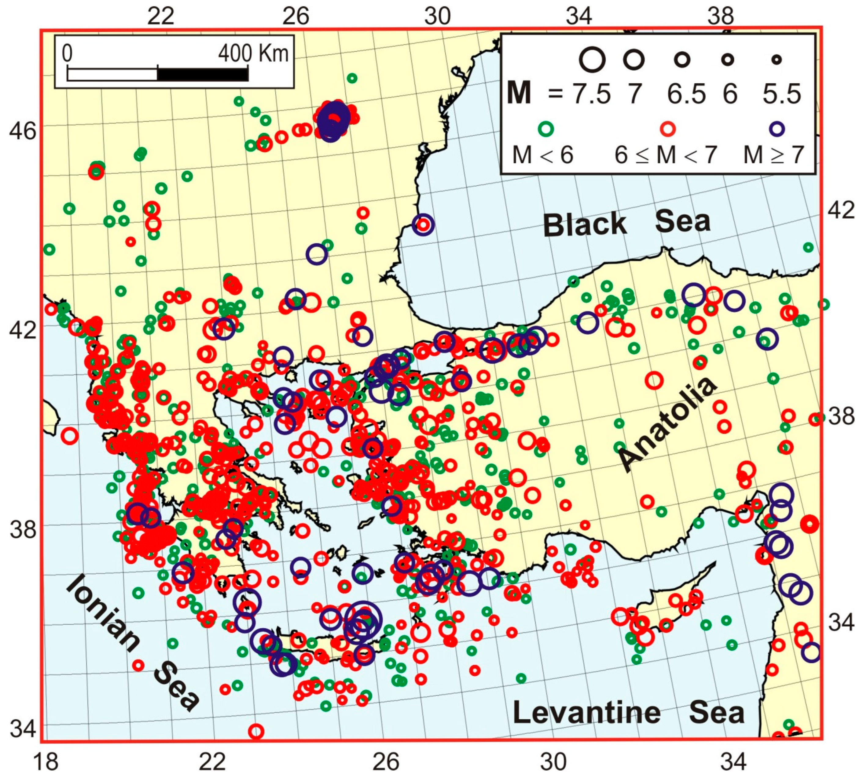
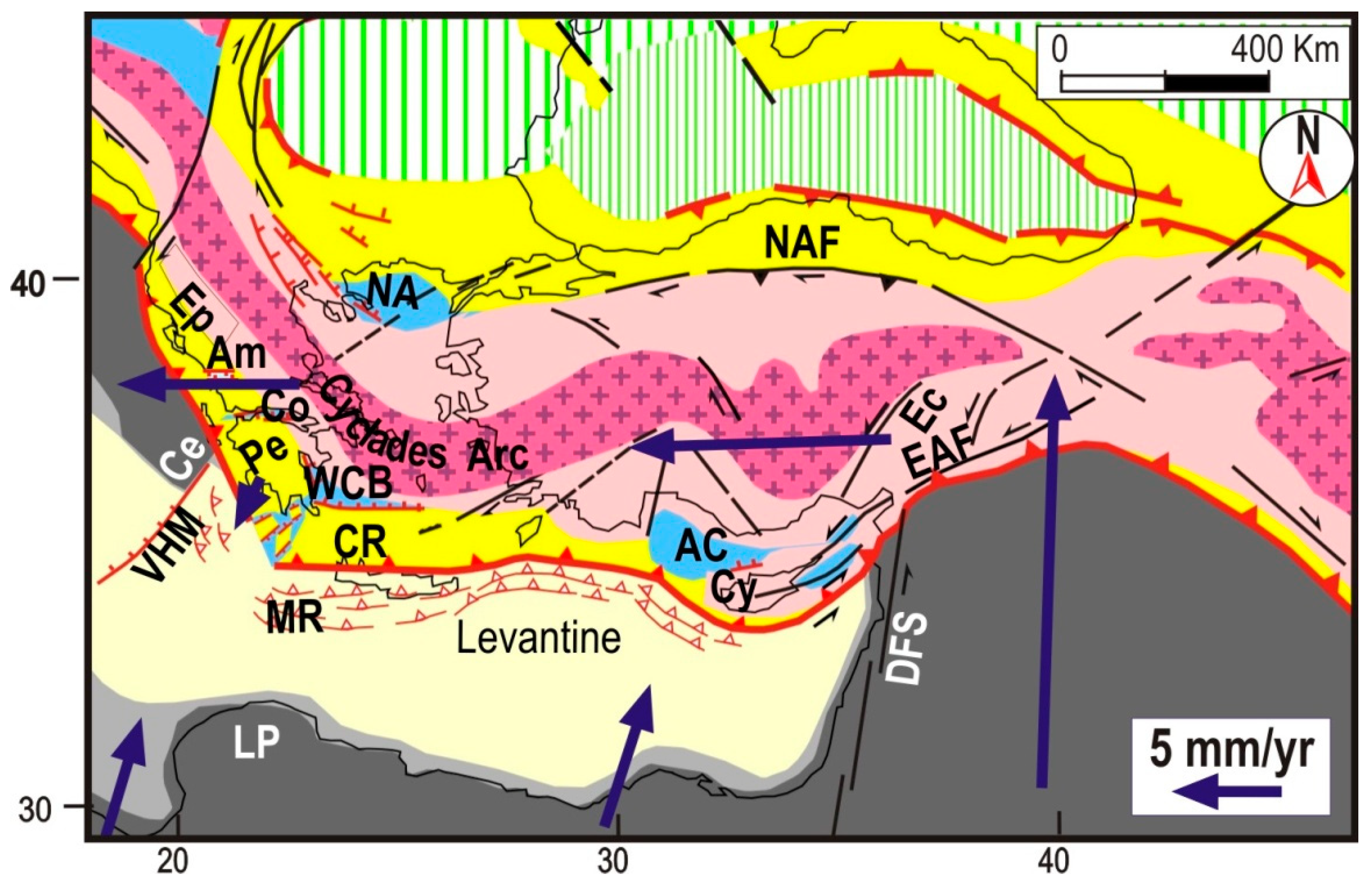
- Another major problem of the slab-pull model is the fact that, since the late Miocene, the zone running from central Greece to Albania has been affected by strong E-W compressional deformation, such as crustal thickening and a strong uplift (e.g., [94,103,104,105]), which is considered to be responsible for the southward escape of the Peloponnesus wedge and for the formation of E-W troughs, such as the Corinth and Ambracique ones (Figure 5, [41,52,107,108]). This compressional stress regime is still going on, as testified by the strong and frequent seismic activity characterized by compressional and transpressional mechanisms ([67] and references therein). The above evidence can hardly be reconciled with an SW-ward pull, whereas it can simply be interpreted as a consequence of the E-W convergence between the Cycladic arc and the Adriatic continental domain.
- The present shape of the inner metamorphic core of the Tethyan belt does not show any significant interruption or thinning in the Aegean and Anatolian sectors (Figure 5A). This structural continuity would imply that the retreat of the Hellenic slab did not only pull the Aegean sector of the belt, it would have also pulled the entire Anatolian body, a result that cannot easily be imputed to the retreat of a relatively narrow slab.
- The marked oroclinal bendings of the Aegean arc (Figure 5A) can hardly be explained as an effect of a pull. This deformation would have required a much faster trench retreat in the central part of the arc with respect to the lateral sectors, implying a very peculiar shape of the sinking slab. Conversely, the bowing can easily be interpreted as an effect of the E-W compression induced by the convergence between eastern Anatolia and the Adriatic continental domain.
- The complex space–time distribution of Plio-Quaternary strain regimes in the Aegean zone is rather different from the one that usually develops in a back arc basin ([24,25,67] and references therein). The northern Aegean zone has been affected by a sinistral transtensional regime. The Central Aegean (Cyclades arc) has simultaneously undergone E-W compression and S-N extension. The southern Aegean was affected by SW-NE extension in the Pliocene (western Cretan basin) and by S-N extension in the Pleistocene (eastern Cretan basin). It seems rather difficult to explain such a complex deformation pattern with the implications of a simple slab-pull driving mechanism. In particular, a southward pull cannot explain the strong E-W compression that was clearly recorded in the Cyclades massifs (e.g., [36]). The above-mentioned authors took into account the possibility that such a deformation is related to the westward displacement of Anatolia, but they concluded that this hypothesis could not explain the fact that E-W shortening in the Cyclades started developing in the early Miocene when the NAF was not yet active. However, this last consideration does not consider that, in the early Miocene, the Tethyan belt was already undergoing belt-parallel compression, driven by the Arabian indenter ([52] and references therein). This regime accelerated in the early Miocene, after the complete consumption of the Magura oceanic zone in front of the migrating Carpathian arc, which considerably increased the resistance against any further NW-ward displacement of the Tethyan belt. This may explain why the outward bending of the Tethyan belt, at the expense of the Levantine–Ionian domain, began at that time, causing a coeval NE-SW extension and belt-parallel compression in the Tethyan belt, which is considered the genetic mechanism of the crustal deformation and petrological evolution of the Cyclades massifs (e.g., [36]).
3.2. Gravitational Spreading
- To explain the bowing of the Hellenic arc (Figure 1), one should assume that the spreading rate in the central part of the Arc was higher than in the lateral sectors, in such a regular distribution to produce an Arc shape.
- The E-W shortening recognized in the Cycladic arc [36] cannot easily be explained as an effect of the gravitational spreading of the Aegean masses towards the Ionian–Levantine domains.
- The crust of the Nubian plate is thicker than the one of the Levantine and Ionian domains, so one should explain why gravitational spreading did not occur at that boundary zone.
4. Nubia–Eurasia Relative Motion
- The southern part of the Adriatic plate moves roughly NE-ward with respect to Eurasia, as suggested by many authors on the basis of geological, geophysical and geodetic information [67,172,173,174,175,176,177]. Since this motion trend is almost perpendicular to the NW-ward Nubia–Eurasia convergence trend provided by GKM, one could expect to observe a clear Nubia–Adria decoupling zone characterized by significant seismotectonic activity. In particular, the divergence between the Adria plate and the Ionian domain (belonging to the Nubian plate) should produce clear extensional deformations in a zone more or less corresponding to the Apulian escarpment. However, no significant active deformation has been recognized in that structure and its surroundings (e.g., [178]). Numerous attempts at identifying other possible decoupling zones have been undertaken, but the variety of solutions so far proposed, located all over the Adria plate, testifies the scarce significance of the available tectonic and seismic evidence in support of a decoupling fault (e.g., [170,179] and references therein). Even though one could identify the invoked decoupling, it would remain the problem of identifying the driving force responsible for the independent motion of the Adriatic plate. The Nubia–Eurasia convergence trend adopted in this work (SSW-NNE) strongly mitigated the problem mentioned above.
- The morphology of the outer Hellenic arc is characterized by a SE-NW trench and SW-NE sinistral strike-slip fault systems (Pliny and Strabo, Figure 5). These features, with particular regard to the deformation pattern of the Crete–Rhodes structure discussed earlier (Figure 9), can hardly be reconciled with the presumed NW motion of Nubia. This problem could only be mitigated by assuming that the SW-ward motion of the Aegean arc was much faster than the Nubia–Eurasia convergence. However, the long-term kinematics of this zone derived by geological data and by the present shape of the subducted lithosphere do not support such a possibility. Similar considerations can be determined for the Cyprus–Nubia boundary, constituted by a SE-NW trench and an NE-SW strike-slip fault system (Figure 5A).
- Other major tectonic features in the central and western Mediterranean area can hardly be reconciled with a NW motion of Nubia, as discussed by [66,67,170,171]. In particular, the SW-ward extrusion of the Calabrian wedge at the expense of the Ionian domain, clearly indicated by the strong deformation, uplift and fracturing of that structure, can hardly be reconciled with a NW ward motion of Nubia (e.g., [127,128]).
5. Conclusions
- (a)
- The deformations observed in the Mediterranean region were driven by the convergence between the surrounding plates (Nubia, Arabia and Eurasia), without any additional driving force, as provided by Plate Tectonics.
- (b)
- (c)
- The very complex distribution of the shortening processes which accommodated such boundary conditions in each evolutionary phase was controlled by the minimum-action principle. At the end of a shortening process in a given zone (due, for instance, to the suture of a consuming boundary), the tectonic framework changed in order to activate the most convenient shortening pattern. This concept is very useful to understand the numerous tectonic reorganisations that have occurred in the study area since the Oligocene [52,66,67,128,129,172]. To complete the above view, it must be taken into account that the subduction of an oceanic lithosphere cannot simply be induced by plate collision. The triggering of that process requires the effects of the lateral escape of orogenic wedges. In fact, the consumption of the remnant oceanic domains in the Mediterranean region took place in front of migrating arcs.
- (d)
- Old belts, with an upper crust modified by the intrusion of lower crustal material, may deform in a dominant ductile way. This behaviour is suggested by the deformation pattern of the inner part of the Anatolian–Aegean–Pelagonian Tethyan belt. A strain field which can produce the crustal modification mentioned above is the contemporaneous occurrence of extension and perpendicular shortening, as was clearly recognized in the Cycladic arc [36].
- (e)
- The mainly brittle behaviour of the outer parts of the Tethyan belt was clearly evidenced by the major break of the Hellenic arc, which led to the separation between the western and eastern branches of this arc, and by the following strong fracturation of the resulting fragments (Crete–Rhodes and Peloponnesus). Similar considerations were suggested by the deformation pattern of the Cyprus arc.
Author Contributions
Funding
Institutional Review Board Statement
Informed Consent Statement
Data Availability Statement
Acknowledgments
Conflicts of Interest
References
- Mantovani, E.; Tamburelli, C.; Babbucci, D.; Viti, M.; Cenni, N. Tectonics and Seismicity in the Periadriatic Zones: Implica-tions for Seismic Hazard in Italy. In Earthquakes—From Tectonics to Buildings; Salazar, W., Ed.; IntechOpen: London, UK, 2020. [Google Scholar]
- Mantovani, E. Understanding Mediterranean Tectonics to Recognise Earthquake-prone Zones. Scientia 2021. [Google Scholar] [CrossRef]
- Shebalin, N.V.; Karnik, V.; Hadzievski, D. UNDP-Unesco Survey of the Seismicity of Balkan Region. In Catalogue of Earthquakes (Part I, 1901-70); Printing of the University Kiril and Metodij: Skopje, Macedonia, 1974. [Google Scholar]
- Ben-Menahem, A. Earthqake catalogue for the Middle East (92 B.C–1980 A.D.). Boll. Geofis. Teor. Appl. 1979, 84, 245–310. [Google Scholar]
- Poirier, J.P.; Taher, M.A. Historical seismicity in the near and middle East, North Africa and Spain from Arabic documents (VIIth–XVIIIth century). Bull. Seism. Soc. Am. 1980, 70, 2185–2201. [Google Scholar] [CrossRef]
- Kondorskaya, N.V.; Shebalin, N.V. New catalog of strong earthquakes in the U.S.S.R. from ancient times through 1977. World Data Cent. A Solid Earth Sci. 1982, 31, 173. [Google Scholar]
- Ambraseys, N.N. Material for the investigation of the seismicity of Tripolitania (Libya). Boll. Geof. Teor. Appl. 1984, 103, 143–155. [Google Scholar]
- Comninakis, P.E.; Papazachos, B.C. A catalogue of earthquakes in Greece and the surrounding area for the period 1901–1985. Univ. Thessalon. Geophys. Lab. Publ. 1986, 1, 167. [Google Scholar]
- Al Hakeem, K. Studying of historical earthquakes activity in Syria. In Workshop on Historical Seismicity of Central-Eastern Mediterranean Region; Margottini, C., Serva, L., Eds.; ENEA-IAEA: Rome, Italy, 1988. [Google Scholar]
- Godey, S.; Bossu, R.; Guilbert, J.; Mazet-Roux, G. The Euro-Mediterranean Bulletin: A comprehensive seismological bulletin at regional scale. Seismol. Res. Lett. 2006, 77, 460–474. [Google Scholar] [CrossRef]
- Ekström, G.; Nettles, M.; Dziewoński, A. The global CMT project 2004–2010: Centroid-moment tensors for 13,017 earthquakes. Phys. Earth Planet. Inter. 2012, 201, 1–9. [Google Scholar] [CrossRef]
- Grünthal, G.; Wahlström, R. The European-Mediterranean Earthquake Catalogue (EMEC) for the last millennium. J. Seism. 2012, 16, 535–570. [Google Scholar] [CrossRef]
- Makropoulos, K.; Kaviris, G.; Kouskouna, V. An updated and extended earthquake catalogue for Greece and adjacent areas since 1900. Nat. Hazards Earth Syst. Sci. 2012, 12, 1425–1430. [Google Scholar] [CrossRef]
- Sesetyan, K.; Demircioglu, M.; Rovida, A.; Albini, P.; Stucchi, M.; Zare, M.; Viganò, D.; Locati, M. SHARE-CET, the SHARE Earthquake Catalogue for Central and Eastern Turkey Complementing the SHARE European Catalogue (SHEEC). 2012. Available online: https://www.emidius.eu/SHEEC/ (accessed on 18 January 2022).
- Stucchi, M.; Rovida, A.; Capera, A.A.G.; Alexandre, P.; Camelbeeck, T.; Demircioglu, M.B.; Gasperini, P.; Kouskouna, V.; Musson, R.M.W.; Radulian, M.; et al. The SHARE European Earthquake Catalogue (SHEEC) 1000–1899. J. Seismol. 2013, 17, 523–544. [Google Scholar] [CrossRef]
- Rovida, A.; Locati, M.; Camassi, R.; Lolli, B.; Gasperini, P.; Antonucci, A. Italian Parametric Earthquake Catalogue (CPTI15), Version 3.0.; Istituto Nazionale di Geofisica e Vulcanologia (INGV): Rome, Italy, 2021. [Google Scholar] [CrossRef]
- Barka, A.A. Slip distribution along the North Anatolian fault associated with large earthquakes of the period 1939 to 1967. Bull. Seism. Soc. Am. 1996, 86, 1238–1254. [Google Scholar]
- Mantovani, E.; Viti, M.; Cenni, N.; Albarello, D.; Babbucci, D. Short and long term deformation patterns in the Aegean-Anatolian Systems: Insights from space geodetic data (GPS). Geophys. Res. Lett. 2001, 28, 2325–2328. [Google Scholar] [CrossRef]
- Cenni, N.; D’Onza, F.; Viti, M.; Mantovani, E.; Albarello, D.; Babbucci, D. Post seismic relaxation processes in the Aegean-Anatolian system: Insights from space geodetic data (GPS) and geological/geophysical evidence. Boll. Geofis. Teor. Appl. 2002, 43, 23–36. [Google Scholar]
- Makris, J.; Papoulia, J.; Yegorova, T. A 3-D density model of Greece constrained by gravity and seismic data. Geophys. J. Int. 2013, 194, 1–17. [Google Scholar] [CrossRef]
- Kokkalas, S.; Xypolias, P.; Koukouvelas, I.; Doutsos, T. Postcollisional contractional and extensional deformation in the Aegean region. Post-Collisional Tectonics and Magmatism in the Mediterranean Region and Asia. Geol. Soc. Am. Spec. 2006, 490, 97–123. [Google Scholar]
- Kassaras, I.; Kapetanidis, V.; Ganas, A.; Tzanis, A.; Kosma, C.; Karakonstantis, A.; Valkaniotis, S.; Chailas, S.; Kouskouna, V.; Papadimitriou, P. The New Seismotectonic Atlas of Greece (v1.0) and Its Implementation. Geosciences 2020, 10, 447. [Google Scholar] [CrossRef]
- Pavlopoulos, K.; Kapsimalis, V.; Theodorakopoulou, K.; Panagiotopoulos, I.P. Vertical displacement trends in the Aegean coastal zone (NE Mediterranean) during the Holocene assessed by geo-archaeological data. Holocene 2011, 22, 717–728. [Google Scholar] [CrossRef]
- Tirel, C.; Gueydan, F.; Tiberi, C.; Brun, J.-P. Aegean crustal thickness inferred from gravity inversion. Geodynamical implications. Earth Planet. Sci. Lett. 2004, 228, 267–280. [Google Scholar] [CrossRef]
- Ring, U.; Will, T.; Glodny, J.; Kumerics, C.; Gessner, K.; Thomson, S.; Güngör, T.; Monié, P.; Okrusch, M.; Drüppel, K. Early exhumation of high-pressure rocks in extrusion wedges: Cycladic blueschist unit in the eastern Aegean, Greece, and Turkey. Tectonics 2007, 26, TC2001. [Google Scholar] [CrossRef]
- Mercier, J.L.; Simeakis, K.; Sorel, D.; Vergely, P. Extensional tectonic regimes in the Aegean basins during the Cenozoic. Basin Res. 1989, 2, 49–71. [Google Scholar] [CrossRef]
- Armijo, R.; Meyer, B.; Hubert, A.; Barka, A. Westward propagation of the North Anatolian fault into the northern Aegean: Timing and kinematics. Geology 1999, 27, 267–270. [Google Scholar] [CrossRef]
- Ferentinos, G.; Georgiou, N.; Christodoulou, D.; Geraga, M.; Papatheodorou, G. Propagation and termination of a strike slip fault in an extensional domain: The westward growth of the North Anatolian Fault into the Aegean Sea. Tectonophysics 2018, 745, 183–195. [Google Scholar] [CrossRef]
- Burchfiel, B.; Nakov, R.; Dumurdzanov, N.; Papanikolaou, D.; Tzankov, T.; Serafimovski, T.; King, R.; Kotzev, V.; Todosov, A.; Nurce, B. Evolution and dynamics of the Cenozoic tectonics of the South Balkan extensional system. Geosphere 2008, 4, 919. [Google Scholar] [CrossRef]
- Fountoulis, I. Quaternary Basin Sedimentation and Geodynamics in SW Peloponnese (Greece) and Late Stage Uplift of Taygetos Mt. Boll. Geofis. Teor. Appl. 2014, 55, 303–324. [Google Scholar] [CrossRef]
- van Hinsbergen, D.; Schmid, S.M. Map view restoration of Aegean-West Anatolian accretion and extension since the Eocene. Tectonics 2012, 31, 5. [Google Scholar] [CrossRef]
- Gaki-Papanastassiou, K.; Maroukian, H.; Kourbanian, V. The morphotectonic evolution of the southern half of Kythira island, Ionian Sea, Greece, during the quaternary. PRACE GEOGRAFICZNE, Instytut Geografii i Gospodarki Przestrzennej UJ Kraków, 127:49–60. Int. J. Earth Sci. 2011, 95, 463–490. [Google Scholar] [CrossRef]
- Veen, J.H.T.; Kleinspehn, K.L. Incipient continental collision and plate-boundary curvature: Late Pliocene–Holocene transtensional Hellenic forearc, Crete, Greece. J. Geol. Soc. 2003, 160, 161–181. [Google Scholar] [CrossRef]
- van Hinsbergen, D.J.J.; Meulenkamp, J.E. Neogene supradetachment basin development on Crete (Greece) during exhuma-tion of the South Aegean core complex. Basin Res. 2006, 18, 103–124. [Google Scholar] [CrossRef]
- Zachariasse, W.; van Hinsbergen, D.; Fortuin, A. Mass wasting and uplift on Crete and Karpathos during the early Pliocene related to initiation of south Aegean left-lateral, strike-slip tectonics. GSA Bull. 2008, 120, 976–993. [Google Scholar] [CrossRef]
- Avigad, D.; Ziv, A.; Garfunkel, Z. Ductile and brittle shortening, extension-parallel folds and maintenance of crustal thick-ness in the central Aegean (Cyclades, Greece). Tectonics 2001, 20, 277–287. [Google Scholar] [CrossRef]
- Searle, M.P.; Lamont, T.N. Compressional Origin of the Aegean Orogeny, Greece. Geosci. Front. 2020, 7, 101049. [Google Scholar] [CrossRef]
- Nocquet, J.-M. Present-day kinematics of the Mediterranean: A comprehensive overview of GPS results. Tectonophysics 2012, 579, 220–242. [Google Scholar] [CrossRef]
- Nyst, M.; Thatcher, W. New constraints on the active tectonic deformation of the Aegean. J. Geophys. Res. Earth Surf. 2004, 109, 2830. [Google Scholar] [CrossRef]
- England, P.; Houseman, G.; Nocquet, J.-M. Constraints from GPS measurements on the dynamics of deformation in Anatolia and the Aegean. J. Geophys. Res. Solid Earth 2016, 121, 8888–8916. [Google Scholar] [CrossRef]
- Armijo, R.; Meyer, B.; King, G.C.P.; Rigo, A.; Papanastassiou, D. Quaternary evolution of the Corinth Rift and its implications for the Late Cenozoic evolution of the Aegean. Geophys. J. Int. 1996, 126, 11–53. [Google Scholar] [CrossRef]
- Sachpazi, M.; Clément, C.; Laigle, M.; Hirn, A.; Roussos, N. Rift structure, evolution, and earthquakes in the Gulf of Corinth, from reflection seismic images. Earth Planet. Sci. Lett. 2003, 216, 243–257. [Google Scholar] [CrossRef]
- Lykousis, V.; Sakellariou, D.; Moretti, I.; Kaberi, H. Late Quaternary basin evolution of the Gulf of Corinth: Sequence stratigraphy, sedimentation, fault-slip and subsidence rates. Tectonophysics 2007, 440, 29–51. [Google Scholar] [CrossRef]
- Papazachos, B.C.; Karakostas, V.G.; Papazachos, C.B.; Scordilis, E.M. The geometry of the Wadati-Benioff zone and litho-spheric kinematics in the Hellenic Arc. Tectonophysics 2000, 319, 275–300. [Google Scholar] [CrossRef]
- Shaw, B.; Jackson, J. Earthquake mechanisms and active tectonics of the Hellenic subduction zone. Geophys. J. Int. 2010, 181, 966–984. [Google Scholar] [CrossRef]
- Le Pichon, X.; Şengör, A.C.; Imren, C.; Şengör, C. A new approach to the opening of the eastern Mediterranean Sea and the origin of the Hellenic subduction zone. Part 2: The Hellenic subduction zone. Can. J. Earth Sci. 2019, 56, 1144–1162. [Google Scholar] [CrossRef]
- Boccaletti, M.; Guazzone, G. Remnant arcs and marginal basins in the Cainozoic development of the Mediterranean. Nature 1974, 252, 18–21. [Google Scholar] [CrossRef]
- Dercourt, J.; Zonenshain, L.; Ricou, L.-E.; Kazmin, V.; Le Pichon, X.; Knipper, A.; Grandjacquet, C.; Sbortshikov, I.; Geyssant, J.; Lepvrier, C.; et al. Geological evolution of the tethys belt from the atlantic to the pamirs since the LIAS. Tectonophysics 1986, 123, 241–315. [Google Scholar] [CrossRef]
- Robertson, A.H.F.; Dixon, J.E.; Brown, S.; Collins, A.; Morris, A.; Pickett, E.; Sharp, I.; Ustaömer, T. Alternative tectonic models for the Late Palaeozoic-Early Tertiary development of Tethys in the Eastern Mediterranean region. Geol. Soc. Lond. Spéc. Publ. 1996, 105, 239–263. [Google Scholar] [CrossRef]
- Finetti, I.; Boccaletti, M.; Bonini, M.; Del Ben, A.; Geletti, R.; Pipan, M.; Sani, F. Crustal section based on CROP seismic data across the North Tyrrhenian–Northern Apennines–Adriatic Sea. Tectonophysics 2001, 343, 135–163. [Google Scholar] [CrossRef]
- Golonka, J. Plate tectonic evolution of the southern margin of Eurasia in the Mesozoic and Cenozoic. Tectonophysics 2004, 381, 235–273. [Google Scholar] [CrossRef]
- Mantovani, E.; Viti, M.; Babbucci, D.; Tamburelli, C.; Albarello, D. Geodynamic Connection between the Indentation of Ara-bia and the Neogene Tectonics of the Central-Eastern Mediterranean Region. In Post-Collisional Tectonics and Magmatism in the Mediterranean Region and Asia; Dilek, Y., Pavlides, S., Eds.; The Geological Society: Boulder, CO, USA, 2006; Volume 490, pp. 15–49. [Google Scholar]
- Handy, M.R.; Schmid, S.M.; Bousquet, R.; Kissling, E.; Bernoulli, D. Reconciling Plate-Tectonic Reconstructions with the Geo-logicalgeophysical Record of Spreading and Subduction in the Alps. Earth Sci. Rev. 2010, 102, 121–158. [Google Scholar] [CrossRef]
- Dilek, Y.; Furnes, H. Tethyan ophiolites and Tethyan seaways. J. Geol. Soc. 2019, 176, 899–912. [Google Scholar] [CrossRef]
- van Hinsbergen, D.J.J.; Torsvik, T.H.; Schmid, S.M.; Ma¸tenco, L.C.; Maffione, M.; Vissers, R.L.M.; Gürer, D.; Spakman, W. Orogenic Architecture of the Mediterranean Region and Kinematic Reconstruction of Its Tectonic Evolution since the Triassic. Gondwana Res. 2020, 81, 79–229. [Google Scholar] [CrossRef]
- Jolivet, L.; Brun, J.P. Cenozoic geodynamic evolution of the Aegean region. Int. J. Earth Sci. 2010, 99, 109–138. [Google Scholar] [CrossRef]
- van Hinsbergen, D.; Langereis, C.; Meulenkamp, J. Revision of the timing, magnitude and distribution of Neogene rotations in the western Aegean region. Tectonophysics 2005, 396, 1–34. [Google Scholar] [CrossRef]
- McKenzie, D. Active tectonics of the Alpine--Himalayan belt: The Aegean Sea and surrounding regions. Geophys. J. Int. 1978, 55, 217–254. [Google Scholar] [CrossRef]
- Le Pichon, X.; Angelier, J. The Hellenic arc and trench system: A key to the neotectonic evolution of the eastern Mediterrane-an area. Tectonophysics 1979, 60, 1–42. [Google Scholar] [CrossRef]
- Mercier, J.L. Extensional-compressional tectonics associated with the Aegean Arc: Comparison with the Andean Cordillera of south Peru north Bolivia. Philos. Trans. R. Soc. Lond. Ser. A Math. Phys. Sci. 1981, 300, 337–355. [Google Scholar] [CrossRef]
- Pe Piper, G.; Piper, D.J.W.; Perissoratis, C. Neotectonics and the Kos plateau Tuff eruption of 161 ka South Aegean arc. J. Volcanol. Geotherm. Res. 2005, 139, 315–338. [Google Scholar] [CrossRef]
- Royden, L.H.; Papanikolaou, D. Slab segmentation and late Cenozoic disruption of the Hellenic arc. Geochem. Geophys. Geosystems 2011, 12, 1–24. [Google Scholar] [CrossRef]
- Faccenna, C.; Becker, T.W.; Auer, L.; Billi, A.; Boschi, L.; Brun, J.P.; Capitanio, F.; Funiciello, F.; Horvàth, F.; Jolivet, L.; et al. Mantle dynamics in the Mediterranean. Rev. Geophys. 2014, 52, 283–332. [Google Scholar] [CrossRef]
- Kissel, C.; Laj, C. The Tertiary geodynamical evolution of the Aegean arc: A paleomagnetic reconstruction. Tectonophysics 1988, 146, 183–201. [Google Scholar] [CrossRef]
- Garfunkel, Z. Origin of the Eastern Mediterranean basin: A reevaluation. Tectonophysics 2004, 391, 11–34. [Google Scholar] [CrossRef]
- Mantovani, E.; Viti, M.; Babbucci, D.; Albarello, D. Nubia-Eurasia Kinematics: An Alternative Interpretation from Mediterranean and North Atlantic Evidence. Ann. Geophys. 2007, 50, 311–336. [Google Scholar] [CrossRef]
- Viti, M.; Mantovani, E.; Babbucci, D.; Tamburelli, C. Plate kinematics and geodynamics in the Central Mediterranean. J. Geodyn. 2011, 51, 190–204. [Google Scholar] [CrossRef]
- Boccaletti, M.; Dainelli, P. Il Sistema Regmatico Neogenico-Quaternario Nell’area Mediterranea: Esempio Di Deformazione Plastico-Rigida Post-Collisionale. Mem. Soc. Geol. Ital. 1982, 24, 465–482. [Google Scholar]
- Ricou, L.E.; Dercourt, J.; Geyssant, J.; Grandjacquet, C.; Lepvrier, C.; BijuDuval, B. Geological constraints on the Alpine evolution of the Mediterranean Tethys. Tectonophysics 1986, 123, 83–122. [Google Scholar] [CrossRef]
- Pourteau, A.; Candan, O.; Oberhänsli, R. High-pressure metasediments in central Turkey: Constraints on the Neotethyan closure history. Tectonics 2010, 29, TC5004. [Google Scholar] [CrossRef]
- Aktas, G.; Robertson, A.H.F. The Maden Complex. Se Turkey: Evolution of a Neotethyan Active Margin. In The Geological Evolution of Eastern Mediterranean; Dixon, J.E., Robertson, A.H.F., Eds.; Geological Society: London, UK, 1984; Volume 17, pp. 375–402. [Google Scholar]
- Hempton, M.R. Structure and deformation history of the Bitlis suture near Lake Hazar, southeastern Turkey. GSA Bull. 1985, 96, 233–243. [Google Scholar] [CrossRef]
- Zonenshain, L.P.; Kuzmin, M.I.; Natapov, L.M. Geology of the USSR: A plate-tectonic synthesis. Geodyn. Monogr. 1990, 21, 242. [Google Scholar]
- Andrieux, J.; Över, S.; Poisson, A.; Bellier, O. The North Anatolian Fault Zone: Distributed Neogene deformation in its northward convex part. Tectonophysics 1995, 243, 135–154. [Google Scholar] [CrossRef]
- Sakınç, M.; Yaltırak, C.; Oktay, F. Palaeogeographical evolution of the Thrace Neogene Basin and the Tethys–Paratethys relations at northwestern Turkey (Thrace). Palaeogeogr. Palaeoclim. Palaeoecol. 1999, 153, 17–40. [Google Scholar] [CrossRef]
- Yılmaz, Y.; Saroğlu, F.; Güner, Y. Initiation of the neomagmatism in East Anatolia. Tectonophysics 1987, 134, 177–199. [Google Scholar] [CrossRef]
- Yılmaz, Y. New evidence and model on the evolution of the southeast Anatolian orogeny. Geol. Soc. Am. Bull. 1993, 105, 251–271. [Google Scholar] [CrossRef]
- Saintot, A.; Angelier, J. Tectonic paleostress fields and structural evolution of the NW-Caucasus fold-and-thrust belt from Late Cretaceous to Quaternary. Tectonophysics 2002, 357, 1–31. [Google Scholar] [CrossRef]
- Nikishin, A.M.; Korotaev, M.V.; Ershov, A.V.; Brunet, M.F. The Black Sea basin: Tectonic history and Neogene–Quaternary rapid subsidence modelling. Sediment. Geol. 2003, 156, 149–168. [Google Scholar] [CrossRef]
- Okay, A.; Zattin, M.; Cavazza, W. Apatite fission-track data for the Miocene Arabia-Eurasia collision. Geology 2010, 38, 35–38. [Google Scholar] [CrossRef]
- Hisarlı, Z.M.; Çinku, M.C.; Ustaömer, T.; Keskin, M.; Orbay, N. Neotectonic deformation in the Eurasia–Arabia collision zone, the East Anatolian Plateau, E Turkey: Evidence from palaeomagnetic study of Neogene–Quaternary volcanic rocks. Geol. Rundsch. 2015, 105, 139–165. [Google Scholar] [CrossRef]
- Koçyiğit, A.; Yılmaz, A.; Adamia, S.; Kuloshvili, S. Neotectonics of East Anatolian Plateau (Turkey) and Lesser Caucasus: Implication for transition from thrusting to strike-slip faulting. Geodin. Acta 2001, 14, 177–195. [Google Scholar] [CrossRef]
- Hubert-Ferrari, A.; King, G.; Manighetti, I.; Armijo, R.; Meyer, B.; Tapponnier, P. Long-term elasticity in the continental lithosphere; modelling the Aden Ridge propagation and the Anatolian extrusion process. Geophys. J. Int. 2003, 153, 111–132. [Google Scholar] [CrossRef]
- Hippolyte, J.-C.; Espurt, N.; Kaymakci, N.; Sangu, E.; Müller, C. Cross-sectional anatomy and geodynamic evolution of the Central Pontide orogenic belt (northern Turkey). Geol. Rundsch. 2015, 105, 81–106. [Google Scholar] [CrossRef]
- Şengör, A.; Kidd, W. Post-collisional tectonics of the Turkish-Iranian plateau and a comparison with Tibet. Tectonophysics 1979, 55, 361–376. [Google Scholar] [CrossRef]
- Dewey, J.F.; Hempton, M.R.; Kidd, W.S.F.; Saroglu, F.; Sengor, A.M.C. Shortening of continental lithosphere: The neotectonics of eastern Anatolia—A young collision Zone. Geol. Soc. Lond. Spec. Publ. 1986, 19, 3–36. [Google Scholar] [CrossRef]
- Pearce, J.A.; Bender, J.F.; De Long, S.E.; Kidd, W.S.F.; Low, P.J.; Güner, Y.; Saroglu, F.; Yilmaz, Y.; Moorbath, S.; Mitchell, J.G. Gen-esis of collision volcanism in Eastern Anatolia, Turkey. J. Volc. Geotherm. Res. 1990, 44, 189–229. [Google Scholar] [CrossRef]
- Şengör, A.M.C.; Görür, N.; Şaroğlu, F. Strike-slip faulting and related basin formation in zones of tectonic escape: Turkey as a case study. Soc. Sediment. Geol. 1985, 37, 227–264. [Google Scholar] [CrossRef]
- Hubert-Ferrari, A.; King, G.; van der Woerd, J.; Villa, I.; Altunel, E.; Armijo, R. Long-term evolution of the North Anatolian Fault: New constraints from its eastern termination. Geol. Soc. Lond. Spéc. Publ. 2009, 311, 133–154. [Google Scholar] [CrossRef]
- Şengör, A.; Tüysüz, O.; Imren, C.; Sakınç, M.; Eyidoğan, H.; Görür, N.; Le Pichon, X.; Rangin, C. The north anatolian fault: A new look. Annu. Rev. Earth Planet. Sci. 2005, 33, 37–112. [Google Scholar] [CrossRef]
- Hubert-Ferrari, A.; Armijo, R.; King, G.C.P.; Meyer, B.; Barka, A. Morphology, displacement and slip rates along the North Anatolian Fault (Turkey). J. Geophys. Res. 2009, 107, B10. [Google Scholar] [CrossRef]
- Schindler, C. Geology of NW Turkey: Results of the Marmara polyproject. In Active Tectonics of Northwestern Anatolia—The Marmara Poly-Project, a Multidisciplinary Approach by Space-Geodesy, Geology, Hydrology, Geothermics and Seismology; Schindler, C., Pfister, M., Eds.; Verlag der Fachvereine: Zurich, Switzerland, 1998. [Google Scholar]
- Gallais, F.; Gutscher, M.-A.; Graindorge, D.; Chamot-Rooke, N.; Klaeschen, D. A Miocene tectonic inversion in the Ionian Sea (central Mediterranean): Evidence from multichannel seismic data. J. Geophys. Res. Earth Surf. 2011, 116, 8505. [Google Scholar] [CrossRef]
- Doutsos, T.; Kontopoulos, N.; Frydas, D. Neotectonic evolution of northwestern-continental Greece. Geol. Rundsch. 1987, 76, 433–450. [Google Scholar] [CrossRef]
- Mercier, J.; Sorel, D.; Simeakis, K. Changes in the state of stress in the overriding plate of a subduction zone: The Aegean Arc from the Pliocene to the Present. Ann. Tecton. 1987, 1, 20–39. [Google Scholar]
- Finetti, I. Mediterranean ridge: A young submerged chain associated with the Hellenic Arc. Boll. Geofis. Teor. Appl. 1976, 19, 31–65. [Google Scholar]
- Mascle, J.; Huguen, C.; Benkhelil, J.; Chamot-Rooke, N.; Chaumillon, E.; Foucher, J.P.; Griboulard, R.; Kopf, A.; Lamarche, G.; Volkonskaia, A.; et al. Images may show start of European-African plate collision. EOS Trans. Am. Geophys. Union 1999, 80, 421–428. [Google Scholar] [CrossRef]
- Kopf, A.; Mascle, J.; Klaeschen, D. The Mediterranean Ridge: A mass balance across the fastest growing accretionary complex on Earth. J. Geophys. Res. Earth Surf. 2003, 108, 2372. [Google Scholar] [CrossRef]
- Angelier, J.; Lybéris, N.; Le Pichon, X.; Barrier, E.; Huchon, P. The tectonic development of the hellenic arc and the sea of crete: A synthesis. Tectonophysics 1982, 86, 159–196. [Google Scholar] [CrossRef]
- Lyon-Caen, H.; Armijo, R.; Drakopoulos, J.; Baskoutass, J.; Delibassis, N.; Gaulon, R.; Kouskouna, V.; Latoussakis, J.; Makropoulos, K.; Papadimitriou, O.; et al. The 1986 Kalamata (South Peloponnesus) earthquake: Detailed study of a normal fault, evidences for East-West extension in the Hellenic arc. J. Geophys. Res. 1988, 93, 14967–15000. [Google Scholar] [CrossRef]
- Mascle, J.; Martin, L. Shallow structure and recent evolution of the Aegean Sea: A synthesis based on continuous reflection profiles. Mar. Geol. 1990, 94, 271–299. [Google Scholar] [CrossRef]
- Meulenkamp, J.E.; Van Der Zwan, G.J.; Van Wamel, W.A. On late Miocene to recent vertical motions in the Cretan segment of the Hellenic arc. Tectonophysics 1994, 234, 53–72. [Google Scholar] [CrossRef]
- Sulstarova, E.; Kociaj, S.; Aliaj, S. Seismic Regionalization of the PSR of Albania; Publication of Academy of Sciences: Tirana, Albania, 1980; p. 297. [Google Scholar]
- Baker, C.; Hatzfeld, D.; Lyon-Caen, H.; Papadimitriou, E.; Rigo, A. Earthquake mechanisms of the Adriatic Sea and western Greece: Implications for the oceanic subduction-continental collision transition. Geophys. J. Int. 1997, 131, 559–594. [Google Scholar] [CrossRef]
- Louvari, E.; Kiratzi, A.A.; Papazachos, B.C. The Cephalonia Transform Fault and its extension to western Lefkada Island (Greece). Tectonophysics 1999, 308, 223–236. [Google Scholar] [CrossRef]
- Kissel, C.; Laj, C.; Poisson, A.; Görür, N. Paleomagnetic reconstruction of the Cenozoic evolution of the Eastern Mediterranean. Tectonophysics 2003, 362, 199–217. [Google Scholar] [CrossRef]
- Amorese, D. Sismotectonique et Déformation Actuelle de la Terminaison Nord-Occidentale de L’arc Égéen (Iles Ioniennes, Acarnanie, Epire, Grèce); Université Joseph-Fourier—Grenoble I: Saint-Martin-d’Hères, France, 1993. [Google Scholar]
- Pérouse, E.; Sébrier, M.; Braucher, R.; Chamot-Rooke, N.; Bourlès, D.; Briole, P.; Sorel, D.; Dimitrov, D.; Arsenikos, S. Transition from collision to subduction in Western Greece: The Katouna–Stamna active fault system and regional kinematics. Geol. Rundsch. 2016, 106, 967–989. [Google Scholar] [CrossRef]
- Seyitoğlu, G.; Scott, B.C. The cause of N-S extensional tectonics in western Turkey: Tectonic escape vs. back-arc spreading vs. orogenic collapse. J. Geodyn. 1996, 22, 145–153. [Google Scholar] [CrossRef]
- Burchfiel, B.C.; Nakov, R.; Tzankov, T.; Royden, L.H. Cenozoic extension in Bulgaria and northern Greece: The northern part of the Aegean extensional regime. In Tectonics and Magmatism in Turkey and Surrounding Area; Bozkurt, E., Ed.; Geological Society of London: London, UK, 2000; Volume 173, pp. 325–352. [Google Scholar]
- Okay, A.I.; Satir, M. Coeval plutonism and metamorphism in a latest Oligocene metamorphic core complex in northwest Turkey. Geol. Mag. 2000, 137, 495–516. [Google Scholar] [CrossRef]
- Le Pichon, X.; Sengör, A.M.C.; Kende, J.; I’mren, C.; Henry, P.; Grall, C.; Karabulut, H. Propagation of a strike-slip plate boundary within an extensional environment: The westward propagation of the North Anatolian Fault. Can. J. Earth Sci. 2016, 53, 1416–1439. [Google Scholar] [CrossRef]
- Lazos, I.; Sboras, S.; Pikridas, C.; Pavlides, S.; Chatzipetros, A. Geodetic analysis of the tectonic crustal deformation pattern in the North Aegean Sea, Greece. Mediterr. Geosci. Rev. 2021, 3, 79–94. [Google Scholar] [CrossRef]
- Boronkay, K.; Doutsos, T. Transpression and transtension within different structural levels in the central Aegean region. J. Struct. Geol. 1994, 16, 1555–1573. [Google Scholar] [CrossRef]
- Rosenbaum, G.; Avigad, D.; Sánchez-Gómez, M. Coaxial flattening at deep levels of orogenic belts: Evidence from blueschists and eclogites on Syros and Sifnos (Cyclades, Greece). J. Struct. Geol. 2002, 24, 1451–1462. [Google Scholar] [CrossRef]
- Gautier, P.; Brun, J.-P.; Moriceau, R.; Sokoutis, D.; Martinod, J.; Jolivet, L. Timing, kinematics and cause of Aegean extension: A scenario based on a comparison with simple analogue experiments. Tectonophysics 1999, 315, 31–72. [Google Scholar] [CrossRef]
- McKenzie, D.P. Plate Tectonics of the Mediterranean Region. Nature 1970, 226, 239–243. [Google Scholar] [CrossRef]
- McKenzie, D. Active Tectonics of the Mediterranean Region. Geophys. J. Int. 1972, 30, 109–185. [Google Scholar] [CrossRef]
- Armijo, R.; Flerit, F.; King, G.; Meyer, B. Linear elastic fracture mechanics explains the past and present evolution of the Aegean. Earth Planet. Sci. Lett. 2004, 217, 85–95. [Google Scholar] [CrossRef]
- Jackson, J.; Gagnepain, J.; Houseman, G.; King, G.; Papadimitriou, P.; Soufleris, C.; Virieux, J. Seismicity, normal faulting, and the geomorphological development of the Gulf of Corinth (Greece): The Corinth earthquakes of February and March 1981. Earth Planet. Sci. Lett. 1982, 57, 377–397. [Google Scholar] [CrossRef]
- Caputo, R.; Pavlides, S. Late Cainozoic geodynamic evolution of Thessaly and surroundings (central-northern Greece). Tectonophysics 1993, 223, 339–362. [Google Scholar] [CrossRef]
- Sorel, D. L’évolution Structurale de la Grèce Nord-Occidentale Depuis le Miocène, Dans le Cadre Géodynamique de l’Arc Égéen. Ph.D. Thesis, Universitè d’Orsay, Paris, France, 1989. [Google Scholar]
- Finetti, I.R. Deep Seismic Exploration of the Central Mediterranean and Italy, Crop Project; Elsevier: Amsterdam, The Netherlands, 2005; p. 794. [Google Scholar]
- Kempler, D.; Garfunkel, Z. Structures and kinematics in the northeastern Mediterranean: A study of an irregular plate boundary. Tectonophysics 1994, 234, 19–32. [Google Scholar] [CrossRef]
- Robertson, A.H.F. Mesozoic–Tertiary tectonic-sedimentary evolution of a south Tethyan oceanic basin and its margins in southern Turkey. In Tectonics and Magmatism in Turkey and the Surrounding Area; Bozkurt, E., Ed.; Geological Society of London: London, UK, 2000; Volume 173, pp. 97–138. [Google Scholar]
- Güneş, P.; Aksu, A.; Hall, J. Structural framework and deformation history of the western Cyprus Arc. Tectonophysics 2018, 744, 438–457. [Google Scholar] [CrossRef]
- Mantovani, E.; Viti, M.; Babbucci, D.; Tamburelli, C.; Cenni, N. Geodynamics of the central-western Mediterranean region: Plausible and non-plausible driving forces. Mar. Pet. Geol. 2019, 113, 104121. [Google Scholar] [CrossRef]
- Viti, M.; Mantovani, E.; Babbucci, D.; Tamburelli, C.; Caggiati, M.; Riva, A. Basic Role of Extrusion Processes in the Late Cenozoic Evolution of the Western and Central Mediterranean Belts. Geosciences 2021, 11, 499. [Google Scholar] [CrossRef]
- Rivard, B.; Arvidson, R.E.; Duncan, I.J.; Sultan, M.; El Kaliouby, B. Varnish, sediment, and rock controls on spectral reflec-tance of outcrops in arid regions. Geology 1992, 20, 295. [Google Scholar] [CrossRef]
- Huguen, C.; Mascle, J.; Chaumillon, E.; Woodside, J.M.; Benkhelil, J.; Kopf, A.; Volkonskaïa, A. Deformational styles of the eastern Mediterranean Ridge and surroundings from combined swath mapping and seismic reflection profiling. Tectonophysics 2001, 343, 21–47. [Google Scholar] [CrossRef]
- Piper, D.J.W.; Perissoratis, C. Quaternary neotectonics of the South Aegean arc. Mar. Geol. 2003, 198, 259–288. [Google Scholar] [CrossRef]
- Veen, J.H.T. Extension of Hellenic forearc shear zones in SW Turkey: The Pliocene–Quaternary deformation of the Eşen Çay Basin. J. Geodyn. 2004, 37, 181–204. [Google Scholar] [CrossRef]
- Duermeijer, C.; Nyst, M.; Meijer, P.; Langereis, C.; Spakman, W. Neogene evolution of the Aegean arc: Paleomagnetic and geodetic evidence for a rapid and young rotation phase. Earth Planet. Sci. Lett. 2000, 176, 509–525. [Google Scholar] [CrossRef]
- Hatzfeld, D.; Besnard, M.; Makropoulos, K.; Voulgaris, N.; Kouskouna, V.; Hatzidimitriou, P.; Panagiotopoulos, P.; Kara-kaisis, G.; Deschamps, A.; Lyon-Caen, H. Subcrustal microearthquake seismicity and fault plane solutions beneath the Hellenic arc. J. Geophys. Res. 1993, 98, 9861–9870. [Google Scholar] [CrossRef]
- Kiratzi, A.A.; Papazachos, C.B. Active seismic deformation in the southern Aegean Benioff zone. J. Geodyn. 1995, 19, 65–78. [Google Scholar] [CrossRef]
- Benetatos, C.; Kiratzi, A.; Papazachos, C.; Karakaisis, G. Focal mechanisms of shallow and intermediate depth earthquakes along the Hellenic Arc. J. Geodyn. 2004, 37, 253–296. [Google Scholar] [CrossRef]
- Konstantinou, K.; Lee, S.-J.; Evangelidis, C.; Melis, N. Source process and tectonic implications of the 8 January 2006 (Mw 6.7) Kythira earthquake, southern Greece. Phys. Earth Planet. Inter. 2009, 175, 167–182. [Google Scholar] [CrossRef]
- Knapmeyer, M.; Harjes, H.-P. Imaging crustal discontinuities and the downgoing slab beneath western Crete. Geophys. J. Int. 2000, 143, 1–21. [Google Scholar] [CrossRef]
- Royden, L.H. Evolution of retreating subduction boundaries formed during continental collision. Tectonics 1993, 12, 629–638. [Google Scholar] [CrossRef]
- Jolivet, L.; Faccenna, C. Mediterranean extension and the Africa-Eurasia collision. Tectonics 2000, 19, 1095–1106. [Google Scholar] [CrossRef]
- Spakman, W.; Wortel, M.J.R.; Vlaar, N.J. The Hellenic subduction zone: A tomographic image and its geodynamic implications. Geophys. Res. Lett. 1988, 15, 60–63. [Google Scholar] [CrossRef]
- Papadopoulos, G.A. On the interpretation of large-scale seismic tomography images in the Aegean sea area. Ann. Geophys. 1997, 40, 1. [Google Scholar] [CrossRef]
- Brun, J.-P.; Sokoutis, D. 45 m.y. of Aegean crust and mantle flow driven by trench retreat. Geology 2010, 38, 815–818. [Google Scholar] [CrossRef]
- Di Stefano, R.; Chiarabba, C.; Lucente, F.; Amato, A. Crustal and Uppermost Mantle Structure in Italy from Inversion of P Wave Arrival Times: Geodynamic Implications. Geophys. J. Int. 1999, 139, 483–498. [Google Scholar] [CrossRef]
- Wortel, M.J.R.; Spakman, W. Subduction and Slab Detachment in the Mediterranean-Carpathian Region. Science 2000, 290, 1910–1917. [Google Scholar] [CrossRef] [PubMed]
- Piromallo, C.; Morelli, A. P Wave Tomography of the Mantle under the Alpine-Mediterranean Area. J. Geophys. Res. 2003, 108, 2065. [Google Scholar]
- Finetti, I.R.; Boccaletti, M.; Bonini, M.; Del Ben, A.; Pipan, M.; Prizzon, A.; Sani, F. Lithospheric Tectono-Stratigraphic Setting of the Ligurian Sea-Northern Apennines-Adriatic Foreland from Integrated CROP Seismic Data. In Crop Project: Deep Seismic Exploration of the Central Mediterranean and Italy; Finetti, I.R., Ed.; Elsevier: Amsterdam, The Netherlands, 2005; Chapter 8; pp. 119–158. [Google Scholar]
- Scafidi, D.; Solarino, S.; Eva, C. P Wave Seismic Velocity and Vp/Vs Ratio beneath the Italian Peninsula from Local Earth-quake Tomography. Tectonophysics 2009, 465, 1–23. [Google Scholar] [CrossRef]
- Scafidi, D.; Solarino, S. Can local earthquake tomography settle the matter about subduction in the Northern and Central Apennines? Response from a new high resolution P velocity and Vp/Vs ratio 3-D model. Tectonophysics 2012, 554–557, 63–73. [Google Scholar] [CrossRef]
- Ranalli, G.; Murphy, D.C. Rheological stratification of the lithosphere. Tectonophysics 1987, 132, 281–295. [Google Scholar] [CrossRef]
- Lobkovsky, L.; Kerchman, V. A two-level concept of plate tectonics: Application to geodynamics. Tectonophysics 1991, 199, 343–374. [Google Scholar] [CrossRef]
- Cloos, M. Lithospheric Buoyancy and Collisional Orogenesis: Subduction of Oceanic Plateaus, Continental Margins, Island Arcs, Spreading Ridges, and Seamounts. GSA Bull. 1993, 105, 715–737. [Google Scholar] [CrossRef]
- Viti, M.; Albarello, D.; Mantovani, E. Rheological profiles in the Central- Eastern Mediterranean. Ann. Geophys. 1997, 40, 849–864. [Google Scholar] [CrossRef]
- Beukel, J.V.D. Some thermomechanical aspects of the subduction of continental lithosphere. Tectonics 1992, 11, 316–329. [Google Scholar] [CrossRef]
- Meissner, R.; Mooney, W. Weakness of Lower Continental Crust: A Condition for Delamination, Uplift and Escape. Tectonophysics 1998, 296, 47–60. [Google Scholar] [CrossRef]
- Ceriani, S.; Schmid, S.M. From N-S Collision to WNW-Directed Post-Collisional Thrusting and Folding: Structural Study of the Frontal Penninic Units in Savoie (Western Alps, France). Eclogae Geol. Helv. 2004, 97, 347–369. [Google Scholar] [CrossRef]
- Rosenberg, C.L.; Kissling, E. 3D Insight into Central Alpine Collision: Lower Plate or Upper Plate Indentation? Geology 2013, 41, 1219–1222. [Google Scholar] [CrossRef]
- Stern, R.J. Subduction Initiation: Spontaneous and Induced. Earth Planet. Sci. Lett. 2004, 226, 275–292. [Google Scholar] [CrossRef]
- Copley, A.; Avouac, J.-P.; Royer, J.-Y. India-Asia collision and the Cenozoic slowdown of the Indian plate: Implications for the forces driving plate motions. J. Geophys. Res. Earth Surf. 2010, 115, 03410. [Google Scholar] [CrossRef]
- Hippolyte, J.C.; Murovskaya, A.; Volfman, Y.; Yegorova, T.; Gintov, O.; Kaymakci, N.; Sangu, E. Age and Geodynamic Evo-lution of the Black Sea Basin: Tectonic Evidences of Rifting in Crimea. Mar. Pet. Geol. 2018, 93, 298–314. [Google Scholar] [CrossRef]
- Shemenda, A.I. Subduction of the lithosphere and back arc dynamics: Insights from physical modeling. J. Geophys. Res. Earth Surf. 1993, 98, 16167–16185. [Google Scholar] [CrossRef]
- Hassani, R.; Jongmans, D.; Chéry, J. Study of plate deformation and stress in subduction processes using two-dimensional numerical models. J. Geophys. Res. Earth Surf. 1997, 102, 17951–17965. [Google Scholar] [CrossRef]
- Capitanio, F.; Stegman, D.; Moresi, L.; Sharples, W. Upper plate controls on deep subduction, trench migrations and deformations at convergent margins. Tectonophysics 2010, 483, 80–92. [Google Scholar] [CrossRef]
- Jolivet, L. A comparison of geodetic and finite strain in the Aegean, geodynamic implications. Earth Planet. Sci. Lett. 2001, 187, 95–104. [Google Scholar] [CrossRef]
- Hatzfeld, D.; Martinod, J.; Bastet, G.; Gautier, P. An analog experiment for the Aegean to describe the contribution of gravitational potential energy. J. Geophys. Res. Earth Surf. 1997, 102, 649–659. [Google Scholar] [CrossRef]
- Papazachos, B.; Papaioannou, C.; Papazachos, C.; Savvaidis, A. Rupture zones in the Aegean region. Tectonophysics 1999, 308, 205–221. [Google Scholar] [CrossRef]
- Savostin, L.A.; Sibuet, J.-C.; Zonenshain, L.P.; Le Pichon, X.; Roulet, M.-J. Kinematic evolution of the Tethys belt from the Atlantic Ocean to the Pamirs since the Triassic. Tectonophysics 1986, 123, 1–35. [Google Scholar] [CrossRef]
- Argus, D.F.; Gordon, R.G.; DeMets, C. Geologically current motion of 56 plates relative to the no-net-rotation reference frame. Geochem. Geophys. Geosystems 2011, 12, 11001. [Google Scholar] [CrossRef]
- DeMets, C.; Iaffaldano, G.; Merkouriev, S. High-resolution Neogene and Quaternary estimates of Nubia-Eurasia-North America Plate motion. Geophys. J. Int. 2015, 203, 416–427. [Google Scholar] [CrossRef]
- Mantovani, E.; Viti, M.; Cenni, N.; Babbucci, D.; Tamburelli, C. Present Velocity Field in the Italian Region by GPS Data: Geodynamic/Tectonic Implications. Int. J. Geosci. 2015, 6, 1285–1316. [Google Scholar] [CrossRef]
- Viti, M.; Mantovani, E.; Tamburelli, C.; Babbucci, D. Generation of trench-arc-backarc systems in the Western Mediterranean region driven by plate convergence. Boll. Soc. Geol. Ital. 2009, 128, 89–106. [Google Scholar]
- Anderson, H.; Jackson, J. Active tectonics of the Adriatic Region. Geophys. J. Int. 1987, 91, 937–983. [Google Scholar] [CrossRef]
- Kuk, V.; Prelogovic, E.; Dragicevic, I. Seismotectonically active zones in the Dinarides. Geol. Croat. 2000, 53, 295–303. [Google Scholar]
- Aliaj, S. The Albanian Orogen: Convergence Zone between Eurasia and the Adria Microplate. In The Adria Microplate: GPS Geodesy, Tectonics and Hazards; Pinter, N., Ed.; Springer: Berlin/Heidelberg, Germany, 2006; pp. 133–149. [Google Scholar]
- Kastelic, V.; Carafa, M.M.C. Fault slip rates for the active External Dinarides thrust-and-fold belt. Tectonics 2012, 31, 3022. [Google Scholar] [CrossRef]
- Cenni, N.; Mantovani, E.; Baldi, P.; Viti, M. Present kinematics of Central and Northern Italy from continuous GPS measurements. J. Geodyn. 2012, 58, 62–72. [Google Scholar] [CrossRef]
- Serpelloni, E.; Faccenna, C.; Spada, G.; Dong, D.; Williams, S.D.P. Vertical GPS ground motion rates in the Euro-Mediterranean region: New evidence of velocity gradients at different spatial scales along the Nubia-Eurasia plate boundary. J. Geophys. Res. Solid Earth 2013, 118, 6003–6024. [Google Scholar] [CrossRef]
- Finetti, I.R.; Del Ben, A. Crustal Tectono-stratigraphic Setting of the Adriatic Sea from new CROP Seismic Data. In Deep Seismic Exploration of the Central Mediterranean and Italy, Crop Project; Finetti, I.R., Ed.; Elsevier: Amsterdam, The Netherlands, 2005; Chapter 23; pp. 519–548. [Google Scholar]
- Babbucci, D.; Tamburelli, C.; Viti, M.; Mantovani, E.; Albarello, D.; D’Onza, F.; Cenni, N.; Mugnaioli, E. Relative motion of the Adriatic with respect to the confining plates: Seismological and geodetic constraints. Geophys. J. Int. 2004, 159, 765–775. [Google Scholar] [CrossRef]
- Nocquet, J.-M.; Willis, P.; Garcia, S. Plate kinematics of Nubia–Somalia using a combined DORIS and GPS solution. J. Geod. 2006, 80, 591–607. [Google Scholar] [CrossRef]
- Bougrine, A.; Yelles-Chaouche, A.K.; Calais, E. Active deformation in Algeria from continuous GPS measurements. Geophys. J. Int. 2019, 217, 572–588. [Google Scholar] [CrossRef]
- Altamimi, Z.; Métivier, L.; Rebischung, P.; Rouby, H.; Collilieux, X. ITRF2014 plate motion model. Geophys. J. Int. 2017, 209, 1906–1912. [Google Scholar] [CrossRef]
- Blanco-Montenegro, I.; Montesinos, F.G.; Arnoso, J. Aeromagnetic anomalies reveal the link between magmatism and tectonics during the early formation of the Canary Islands. Sci. Rep. 2018, 8, 1–14. [Google Scholar] [CrossRef]
- Cabral, J. An example of intraplate neotectonic activity, Vilariça Basin, northeast Portugal. Tectonics 1989, 8, 285–303. [Google Scholar] [CrossRef]
- Ribeiro, A.; Cabral, J.; Baptista, R.; Matias, L. Stress pattern in Portugal mainland and the adjacent Atlantic region. West Iberia. Tecton. 1996, 15, 641–659. [Google Scholar] [CrossRef]
- Borges, J.F.; Fitas, A.J.S.; Bezzeghoud, M.; Tevescosta, P. Seismotectonics of Portugal and its adjacent Atlantic area. Tectonophysics 2001, 337, 373–387. [Google Scholar] [CrossRef]
- Vilanova, S.P.; Fonseca, J.F.B.D. Seismic hazard impact of the Lower Tagus Valley Fault Zone (SW Iberia). J. Seismol. 2004, 8, 331–345. [Google Scholar] [CrossRef]
- Jabaloy, A.; Galindo-Zaldivar, J.; Gonzàlez-Lodeiro, F. Palaeostress evolution of the Iberian Peninsula (Late Carboniferous to present-day). Tectonophysics 2002, 357, 159–186. [Google Scholar] [CrossRef]
- Lynnes, C.S.; Ruff, L.J. Source process and tectonic implications of the great 1975 North Atlantic earthquake. Geophys. J. R. Astr. Soc. 1985, 82, 497–510. [Google Scholar] [CrossRef]
- Buforn, E.; Udias, A.; Colombas, M.A. Seismicity, source mechanism and tectonics of the Azores-Gibraltar plate boundary. Tectonophysics 1988, 152, 89–118. [Google Scholar] [CrossRef]
- Le Pichon, X.; Biju-Duval, B. Les Fonds de la Méditerranée; Hachette-Guides Bleus: Paris, France, 1990. [Google Scholar]


Publisher’s Note: MDPI stays neutral with regard to jurisdictional claims in published maps and institutional affiliations. |
© 2022 by the authors. Licensee MDPI, Basel, Switzerland. This article is an open access article distributed under the terms and conditions of the Creative Commons Attribution (CC BY) license (https://creativecommons.org/licenses/by/4.0/).
Share and Cite
Mantovani, E.; Babbucci, D.; Tamburelli, C.; Viti, M. Late Cenozoic Evolution and Present Tectonic Setting of the Aegean–Hellenic Arc. Geosciences 2022, 12, 104. https://doi.org/10.3390/geosciences12030104
Mantovani E, Babbucci D, Tamburelli C, Viti M. Late Cenozoic Evolution and Present Tectonic Setting of the Aegean–Hellenic Arc. Geosciences. 2022; 12(3):104. https://doi.org/10.3390/geosciences12030104
Chicago/Turabian StyleMantovani, Enzo, Daniele Babbucci, Caterina Tamburelli, and Marcello Viti. 2022. "Late Cenozoic Evolution and Present Tectonic Setting of the Aegean–Hellenic Arc" Geosciences 12, no. 3: 104. https://doi.org/10.3390/geosciences12030104
APA StyleMantovani, E., Babbucci, D., Tamburelli, C., & Viti, M. (2022). Late Cenozoic Evolution and Present Tectonic Setting of the Aegean–Hellenic Arc. Geosciences, 12(3), 104. https://doi.org/10.3390/geosciences12030104