3D Engineering Geological Modeling to Investigate a Liquefaction Site: An Example in Alluvial Holocene Sediments in the Po Plain, Italy
Abstract
:1. Introduction
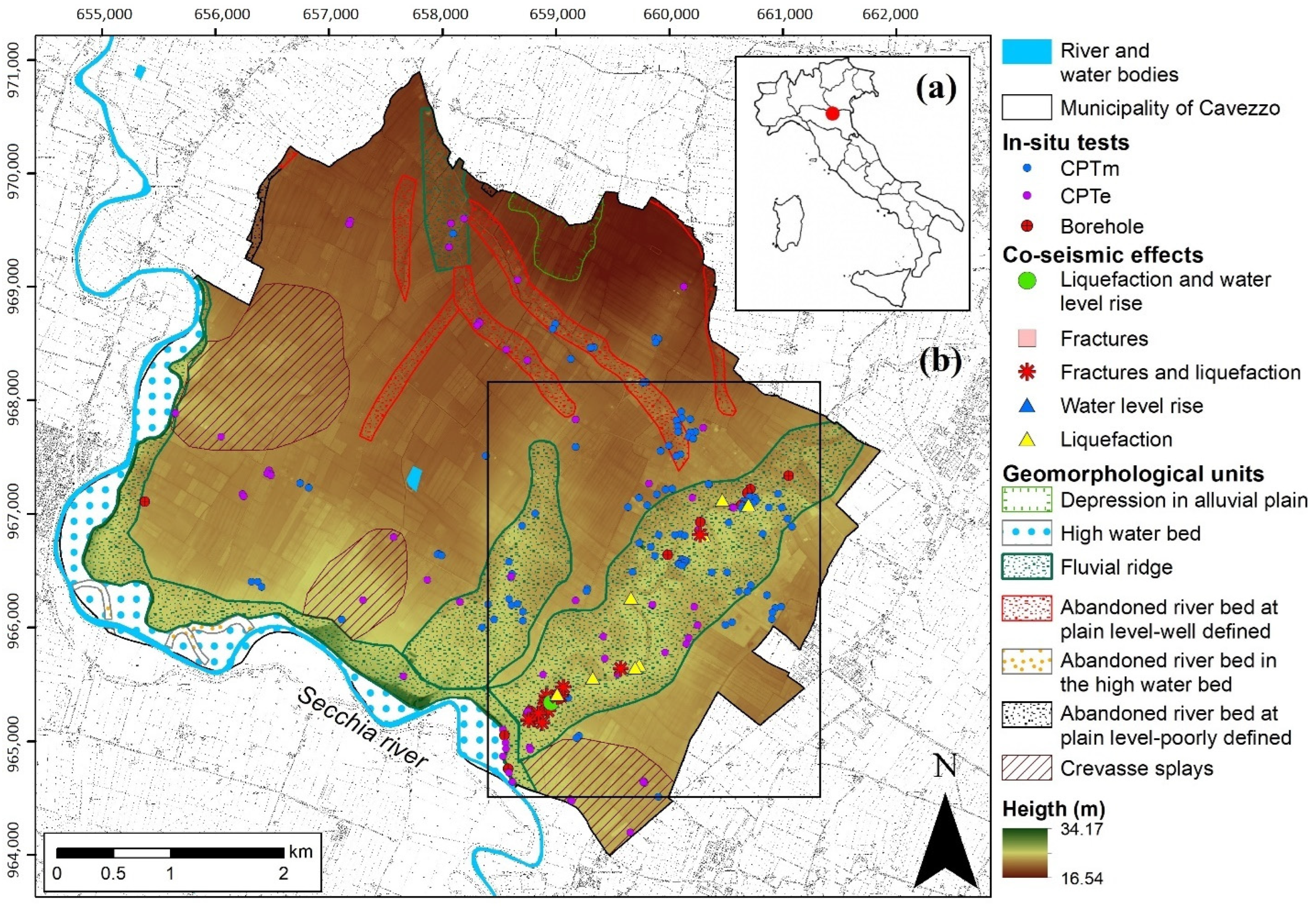
2. Study Area
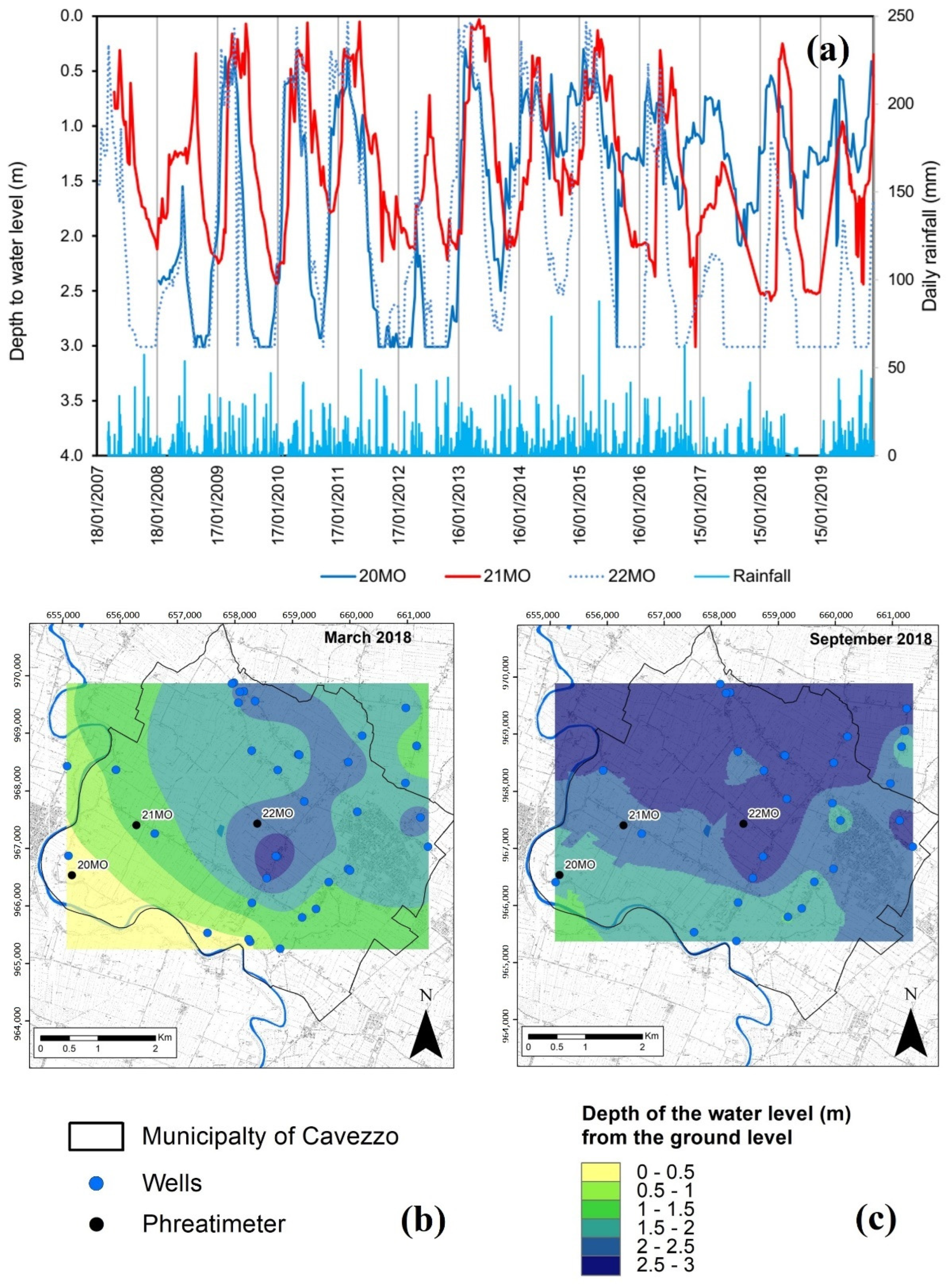
Hydrogeological Setting
3. Geotechnical Investigations
- Database Regione Emilia Romagna (RER);
- LIQUEFACT investigation campaigns, performed by Geostudi Astier in December 2016, as well as Geotecnica Veneta and UNIPV-DSTA (Laboratory tests) in January 2017;
- Post-2012 earthquakes geotechnical investigations (MUDE database);
- Investigation campaigns, funded by “Comune di Cavezzo” and RER, were performed by Tecnoin Geosolution and Elletipi (Laboratory tests) in December 2017 and January 2018.
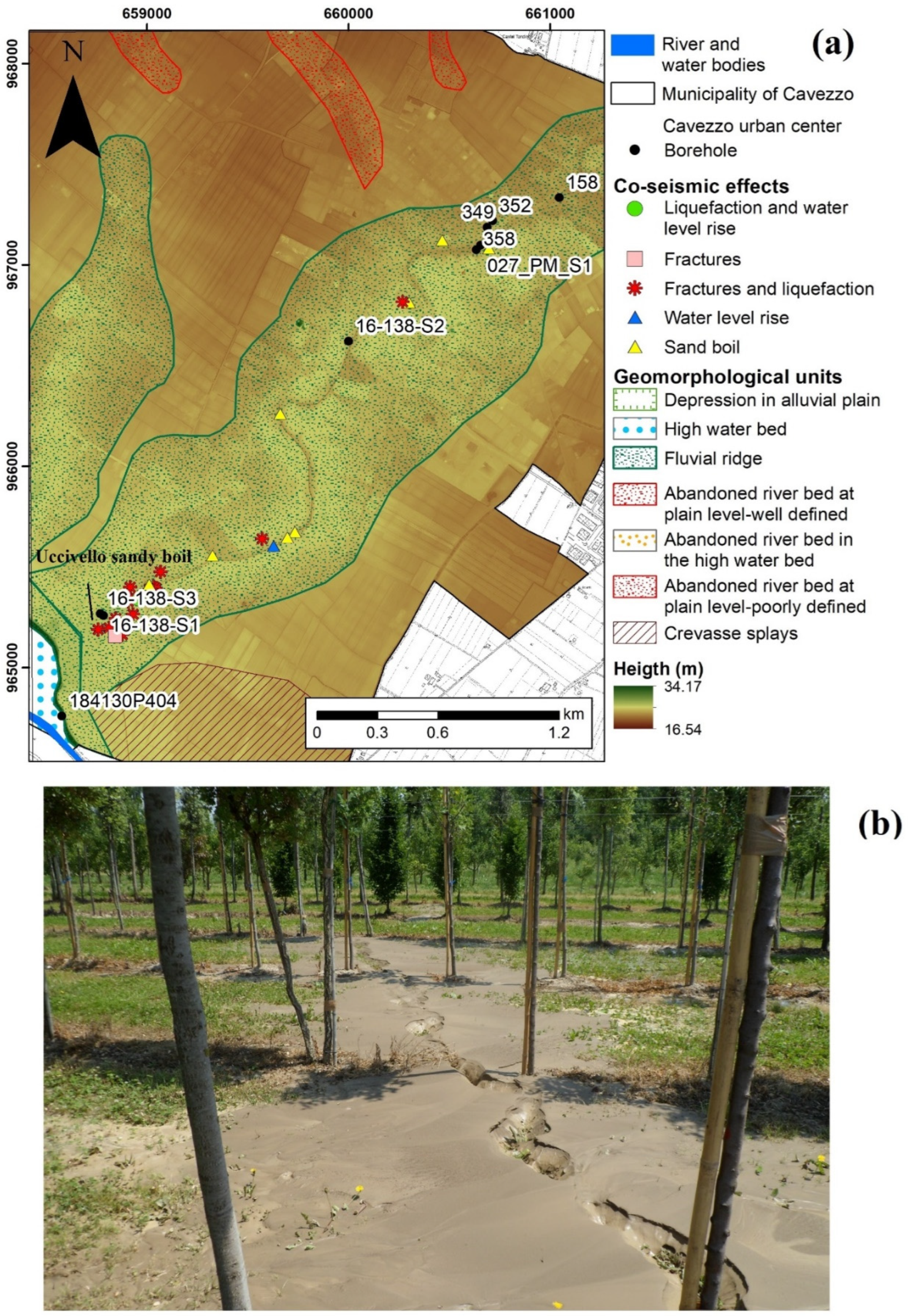
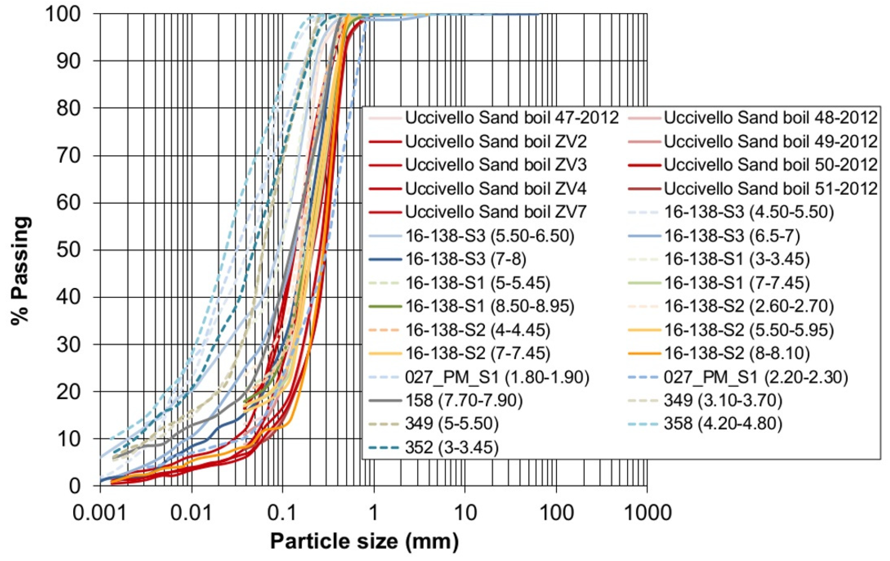
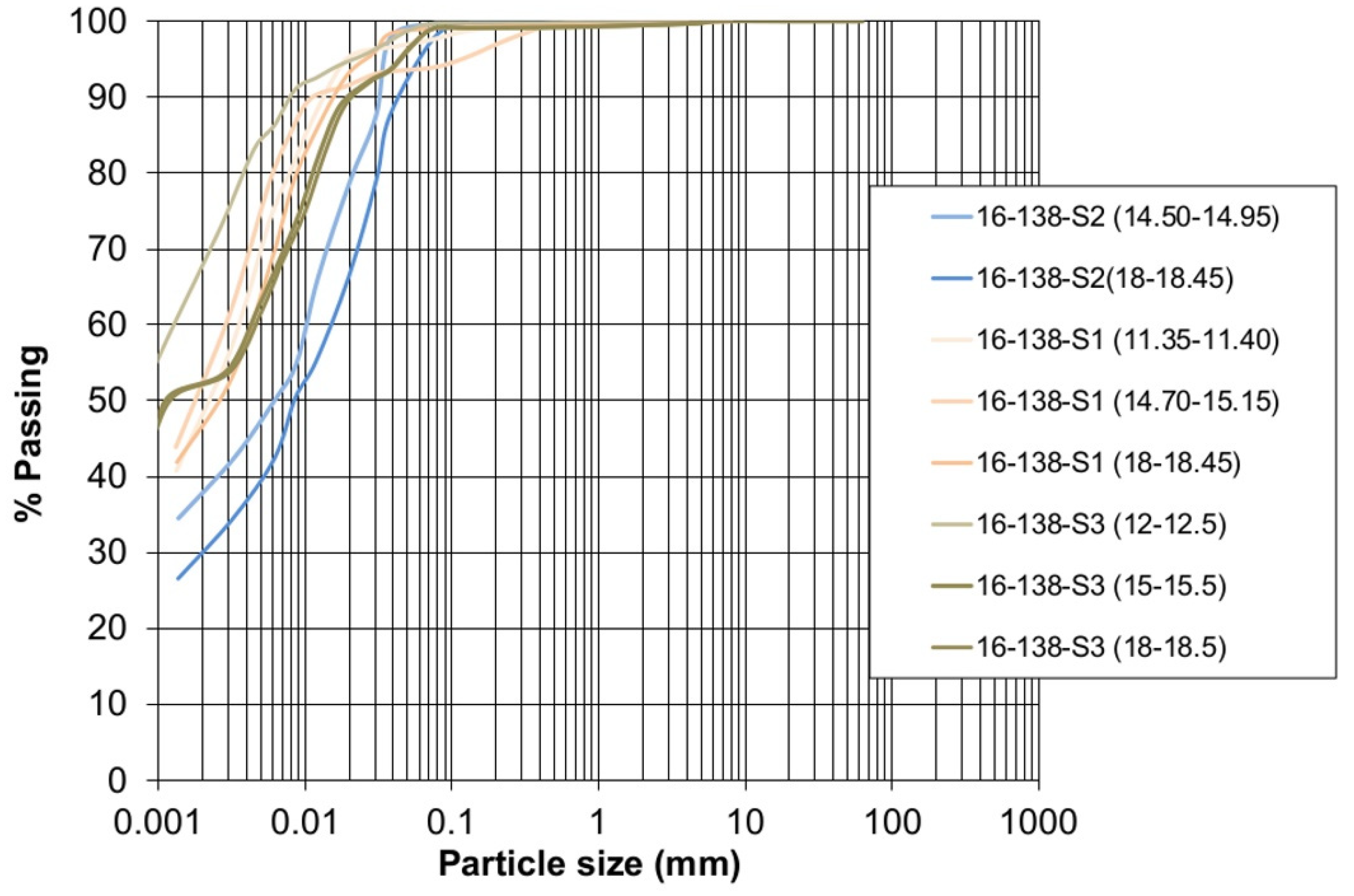
3.1. Borehole and Grain-Size Distribution Analysis
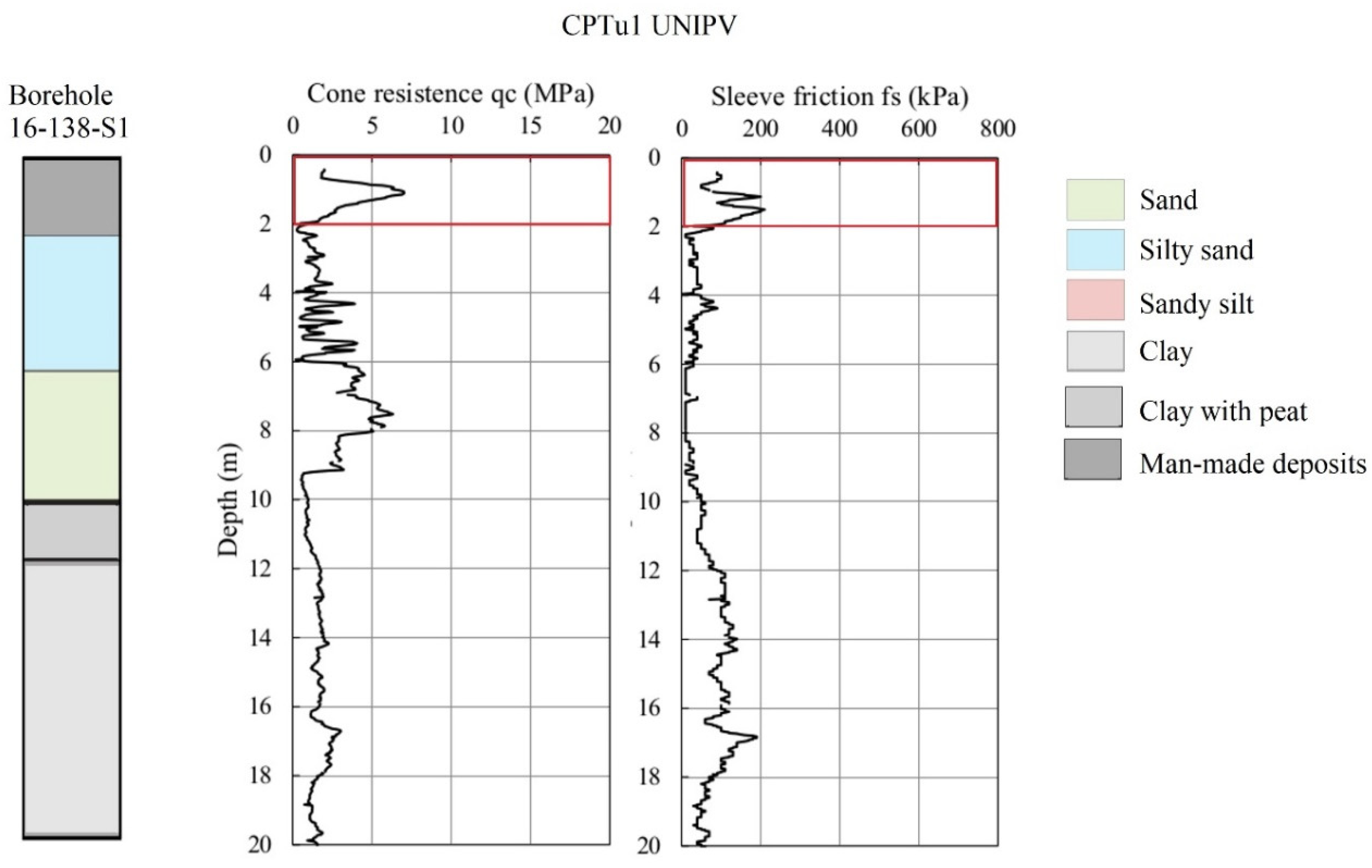
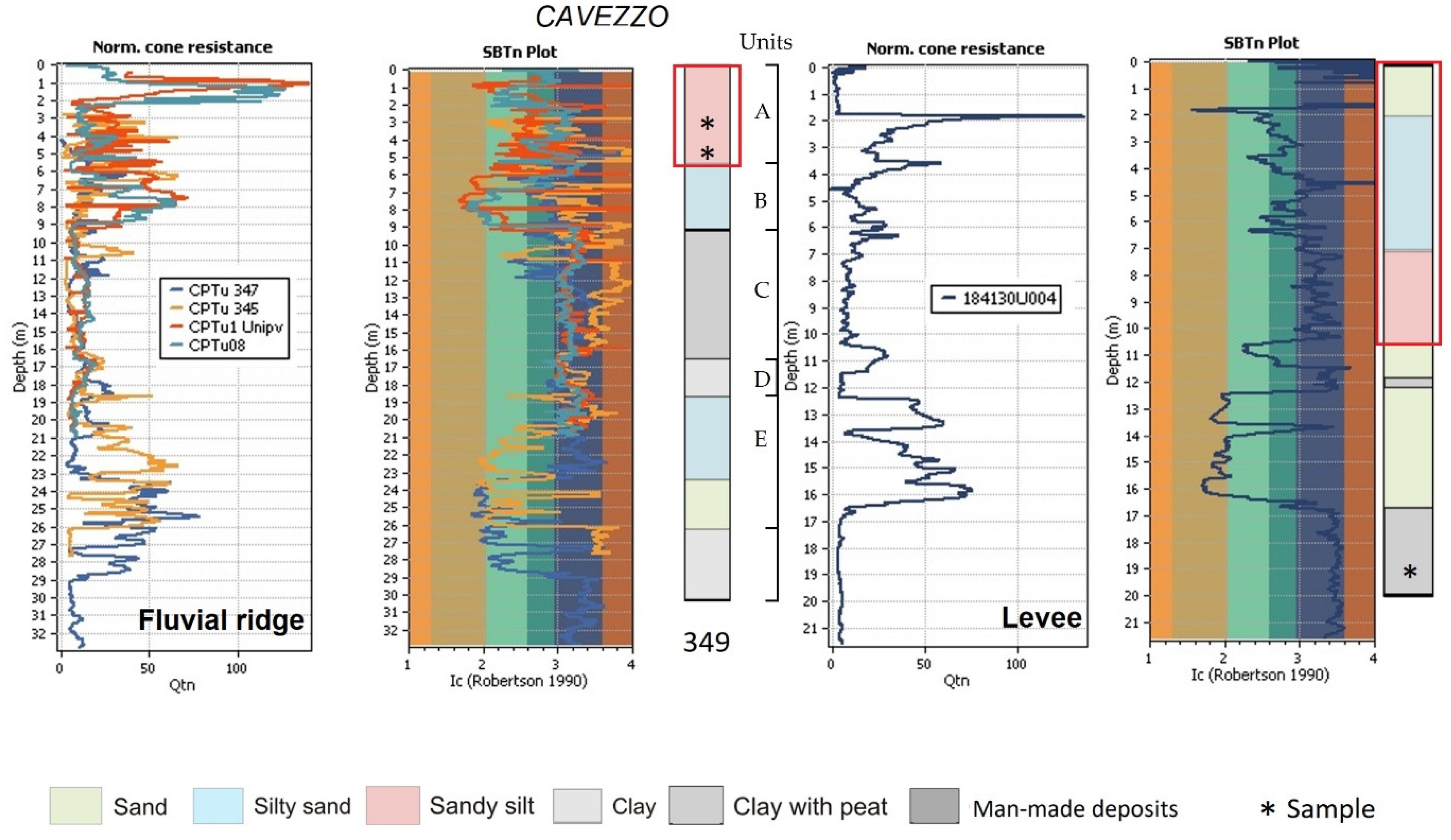
3.2. Cone Penetration Tests
4. Methodology
- Phase 1. Conceptual modelThe first phase is aimed to collect and harmonize the data. The stratigraphic profiles of the 30 m deep sequence, obtained using boreholes logs, mechanical, and electrical cone piezometric tests, are compiled using the detected lithological classes.The database includes the geographic coordinates of each stratigraphic profile, as well as the depth and thickness of each layer.
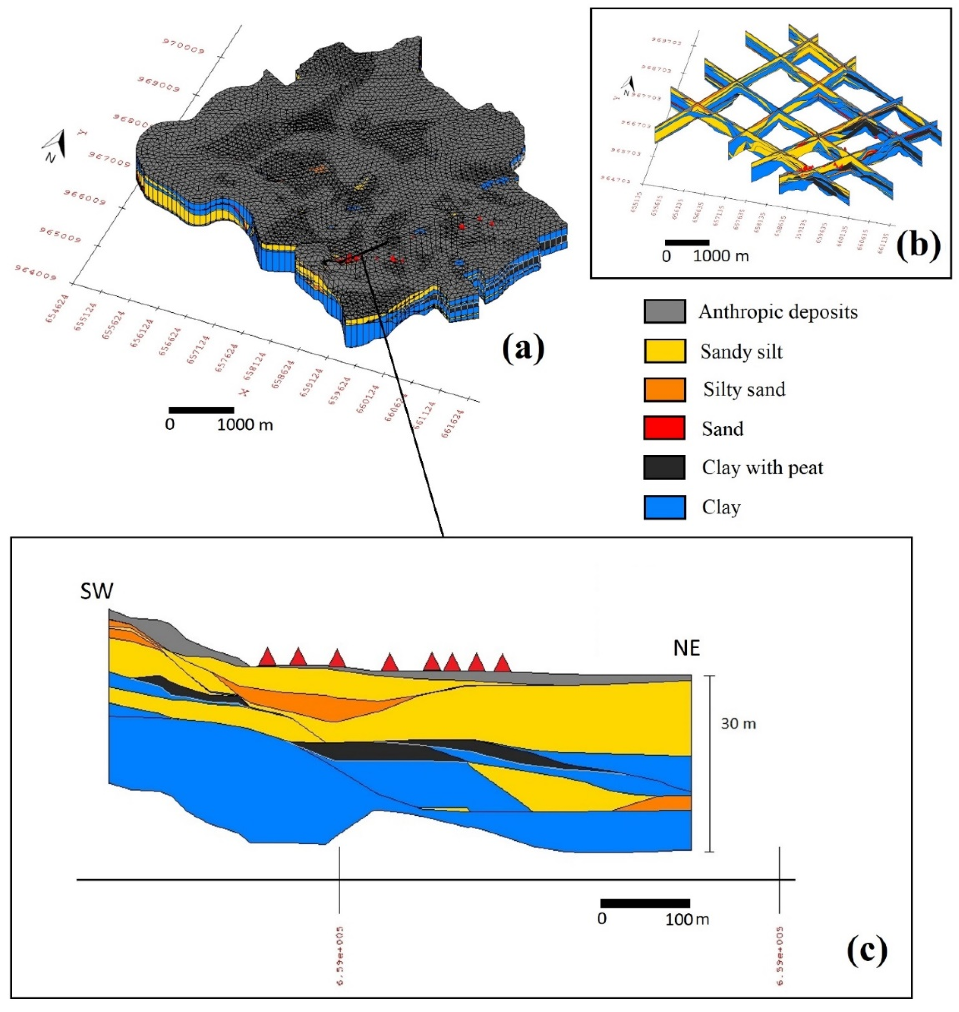
- Phase 2. 3D engineering geological modellingIn the second phase, geological cross-sections are manually drawn by correlating the different lithological units to generate the 3D engineering geological model [39]. The geological cross-sections are drawn longitudinal and transversal to the depositional elements and focus on areas characterized by significant vertical and horizontal variations. The engineering geological model is built up using the “horizons to solids” algorithm via the Groundwater Modelling System (GMS) Aquaveo software. The horizons are numbered consecutively from the bottom to the top. A primary TIN (triangulated irregular network) is created to obtain the 2D mesh of the surface, defining the spatial resolution of the model. The cross-sections are used as a guide, and the horizons allow us to interpolate a surface for each layer.
- Phase 3. Engineering geological units for liquefaction hazard assessment (MOPS)The third phase is aimed to delineate the engineering geological units or microzone for seismic liquefaction hazard assessment (MOPS; “Microzone Omogenee in Prospettiva Sismica” sensu stricto [40]). The MOPS are homogeneous areas, showing similar trends in the depth of Ic behavioural parameters and described by a representative stratigraphic profile.
5. Results
5.1. Conceptual Model
- -
- Unit A; heterogeneous deposits, lithological classes clayey silt, and clayey sandy silt (La, Las), with interbedded thin silty sand (Sl) layers, corresponding to the recent alluvial plain;
- -
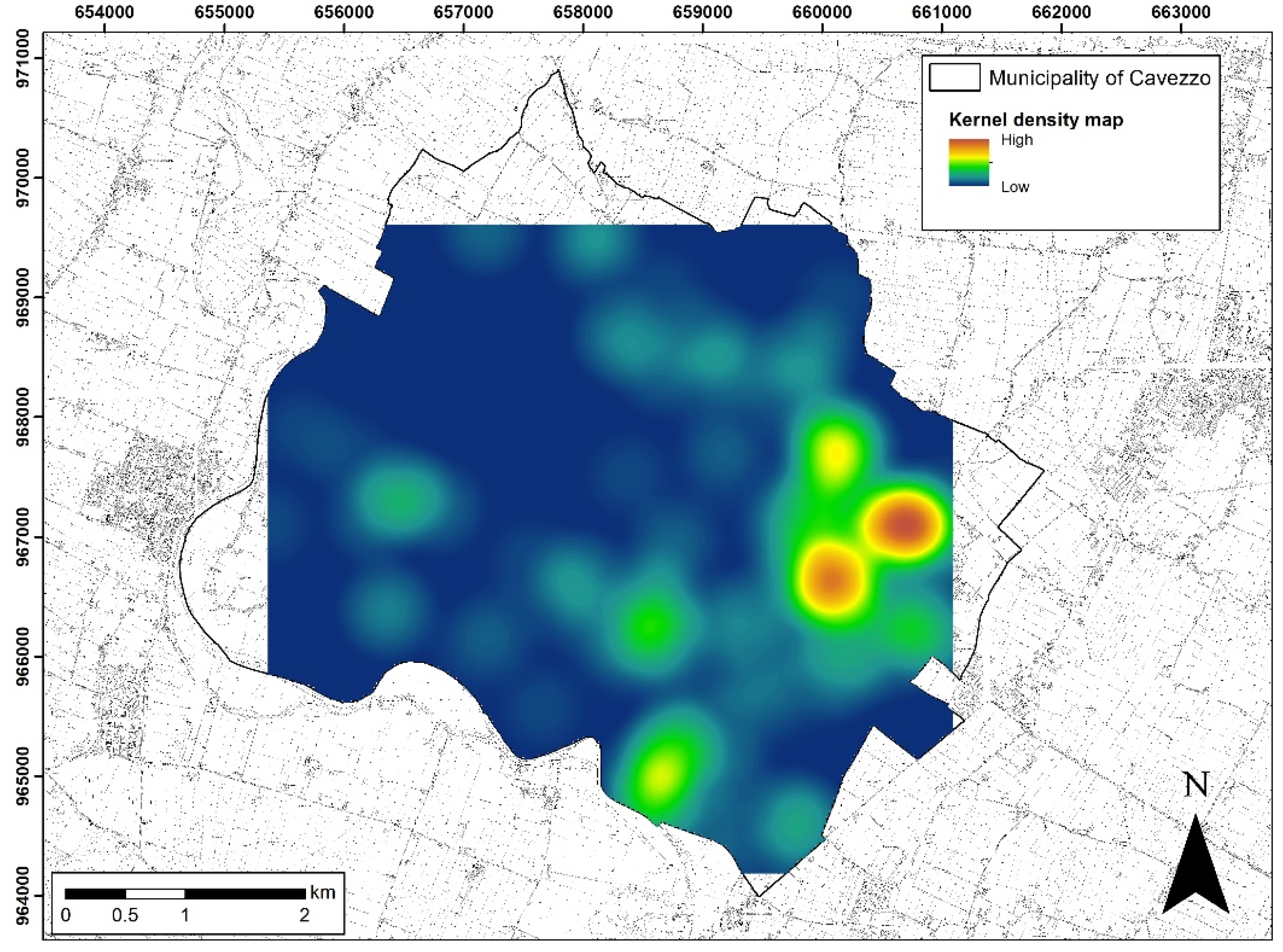
- Unit B; lithological classes sand (S), silty sand (Sl), and sandy silt (Ls), corresponding to the fluvial channel, and these deposits are the source of most of the visible liquefaction effects;
- -
- Unit C; clay (A) and clay with peat (At), corresponding to the palustrine depositional environment;
- -
- Unit D; clay (A) of the ancient alluvial plain;
- -
- Unit E; dense sands of the ancient fluvial channel.
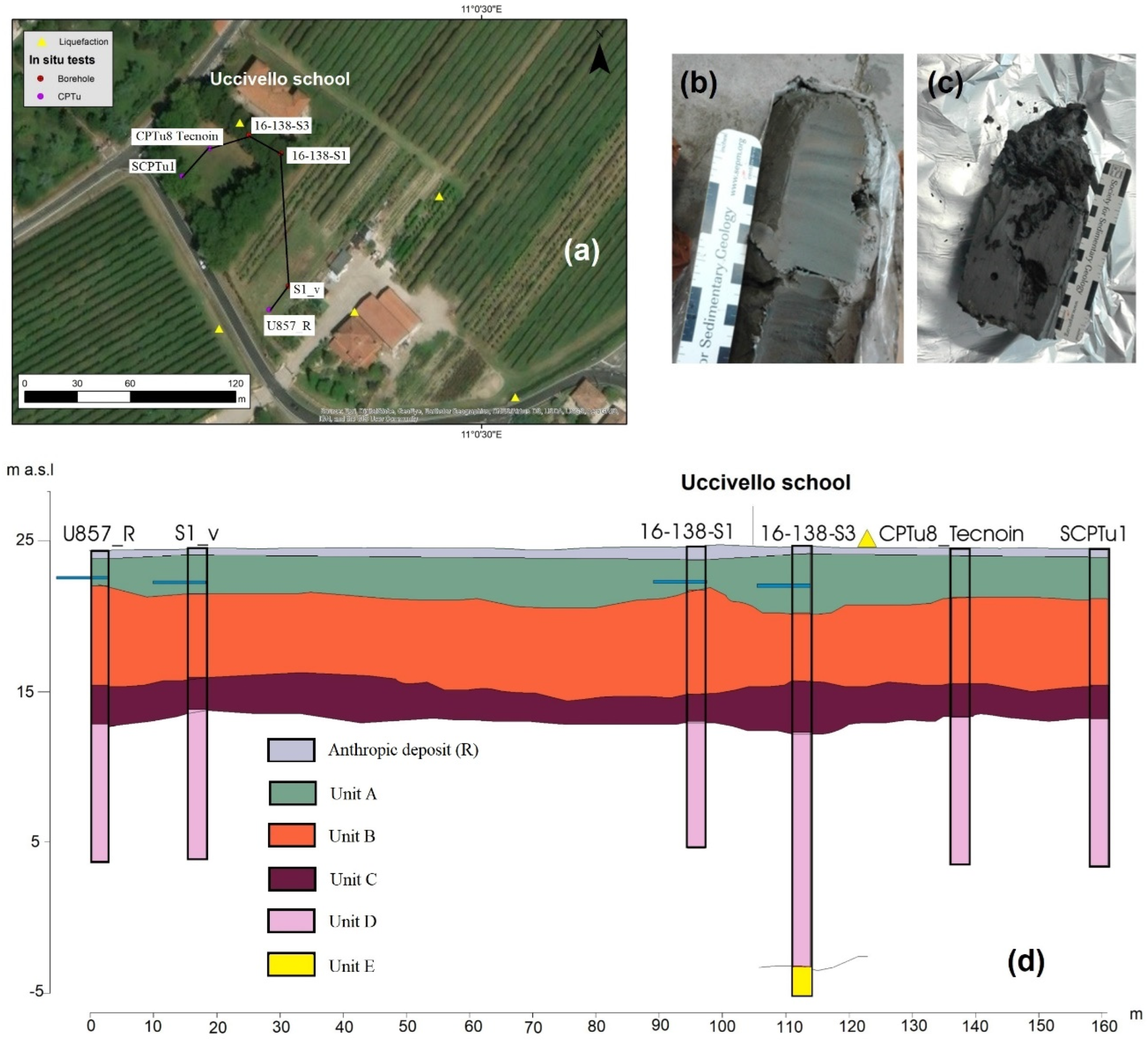
5.2. Construction of a 3D Engineering Geological Model
5.3. Engineering Geological Units for Liquefaction Hazard Assessment (MOPS)
6. Discussion
6.1. Influence of the Sedimentary Architecture on the Surface Manifestations of Liquefaction
6.2. Composition of the Liquefied Layers
7. Conclusions
Supplementary Materials
Author Contributions
Funding
Data Availability Statement
Acknowledgments
Conflicts of Interest
References
- Albano, M.; Barba, S.; Solaro, G.; Pepe, A.; Bignami, C.; Moro, M.; Saroli, M.; Stramondo, S. Aftershocks, groundwater changes and postseismic ground displacements related to pore pressure gradients: Insights from the 2012 Emilia-Romagna earthquake. J. Geophys. Res. Solid Earth 2017, 122, 5622–5638. [Google Scholar] [CrossRef]
- Cubrinovski, M.; Rhodes, A.; Ntritsos, N.; Van Ballegooy, S. System response of liquefiable deposits. Soil Dyn. Earthq. Eng. 2018, 124, 212–229. [Google Scholar] [CrossRef]
- Hurst, A.; Scott, A.; Vigorito, M. Physical characteristics of sand ejecta. Earth-Sci. Rev. 2011, 106, 215–246. [Google Scholar] [CrossRef]
- Fontana, D.; Lugli, S.; Dori, S.M.; Caputo, R.; Stefani, M. Sedimentology and composition of sands ejected during the seismic crisis of May 2012 (Emilia, Italy): Clues for source layer identification and liquefaction regime. Sediment. Geol. 2015, 325, 158–167. [Google Scholar] [CrossRef] [Green Version]
- Fontana, D.; Amoroso, S.; Minarelli, L.; Stefani, M. Sand Liquefaction Induced by a Blast Test: New Insights on Source Layer and Grain-Size Segregation Mechanisms (Late Quaternary, Emilia, Italy). J. Sediment. Res. 2019, 89, 13–27. [Google Scholar] [CrossRef]
- Ishihara, K. Stability of natural deposits during earthquakes. In Proceedings of the Eleventh International Conference on Soil Mechanics and Foundation Engineering, San Francisco, CA, USA, 12–16 August 1985; pp. 321–376. [Google Scholar]
- Bucci, M.G.; Villamor, P.; Almond, P.; Tuttle, M.; Stringer, M.; Ries, W.; Smith, C.; Hodge, M.; Watson, M. Associations between sediment architecture and liquefaction susceptibility in fluvial settings: The 2010–2011 Canterbury Earthquake Sequence, New Zealand. Eng. Geol. 2018, 237, 181–197. [Google Scholar] [CrossRef]
- Amorosi, A.; Bruno, L.; Facciorusso, J.; Piccin, A.; Sammartino, I. Stratigraphic control on earthquake-induced liquefaction: A case study from the Central Po Plain (Italy). Sediment. Geol. 2016, 345, 42–53. [Google Scholar] [CrossRef]
- Beyzaei, C.Z.; Bray, J.D.; van Ballegooy, S.; Cubrinovski, M.; Bastin, S. Depositional environment effects on observed liquefaction performance in silt swamps during the Canterbury earthquake sequence. Soil Dyn. Earthq. Eng. 2018, 107, 303–321. [Google Scholar] [CrossRef]
- Bastin, S.H.; Ogden, M.; Wotherspoon, L.M.; Van Ballegooy, S.; Green, R.A.; Stringer, M. Geomorphological Influences on the Distribution of Liquefaction in the Wairau Plains, New Zealand, Following the 2016 Kaikōura Earthquake. Bull. Seism. Soc. Am. 2018, 108, 1683–1694. [Google Scholar] [CrossRef]
- Bozzano, F.; Esposito, C.; Franchi, S.; Mazzanti, P.; Perissin, D.; Rocca, A.; Romano, E. Understanding the subsidence process of a quaternary plain by combining geological and hydrogeological modelling with satellite InSAR data: The Acque Albule Plain case study. Remote Sens. Environ. 2015, 168, 219–238. [Google Scholar] [CrossRef]
- Thierry, P.; Prunier-Leparmentier, A.-M.; Lembezat, C.; Vanoudheusden, E.; Vernoux, J.-F. 3D geological modelling at urban scale and mapping of ground movement susceptibility from gypsum dissolution: The Paris example (France). Eng. Geol. 2009, 105, 51–64. [Google Scholar] [CrossRef] [Green Version]
- Marache, A.; Breysse, D.; Piette, C.; Thierry, P. Geotechnical modeling at the city scale using statistical and geostatistical tools: The Pessac case (France). Eng. Geol. 2009, 107, 67–76. [Google Scholar] [CrossRef]
- Touch, S.; Likitlersuang, S.; Pipatpongsa, T. 3D geological modelling and geotechnical characteristics of Phnom Penh subsoils in Cambodia. Eng. Geol. 2014, 178, 58–69. [Google Scholar] [CrossRef]
- Calabrese, L.; Perini, L.; Lorito, S.; Luciani, P.; Martini, A.; Severi, P.; Correggiari, A.; Remia, A. 3D modelling of the Holocene succession in the southern Po Delta (Italy): From geology to applications. Z. Dtsch. Ges. Geowiss. 2016, 167, 339–352. [Google Scholar] [CrossRef]
- Begg, J.G.; Jones, K.E.; Rattenbury, M.S.; Barrell, D.J.; Ramilo, R.; Beetham, D. A 3D geological model for Christchurch City (New Zealand): A contribution to the post-earthquake re-build. In Engineering Geology for Society and Territory; Springer: Cham, Switzerland, 2015; Volume 5, pp. 881–884. [Google Scholar]
- Kruiver, P.P.; Wiersma, A.; Kloosterman, F.H.; de Lange, G.; Korff, M.; Stafleu, J.; Busschers, F.S.; Harting, R.; Gunnink, J.L.; Green, R.A.; et al. Characterisation of the Groningen subsurface for seismic hazard and risk modelling. Neth. J. Geosci. 2017, 96, s215–s233. [Google Scholar] [CrossRef] [Green Version]
- Yazarlooa, R.; Khamehchiana, M.; Nikoodela, M.R. Observational-computational 3D Engineering Geological Model and Geotechnical Characteristics of Young Sediments of Golestan Province. In Computational Research Progress in Applied Science & Engineering (CRPASE); PEARL Publication: Dhaka, Bangladesh, 2017; Volume 3. [Google Scholar]
- Dhar, M.S.; Cramer, C.H. Probabilistic Seismic and Liquefaction Hazard Analysis of the Mississippi Embayment Incorporating Nonlinear Effects. Seism. Res. Lett. 2017, 89, 253–267. [Google Scholar] [CrossRef]
- Boccaletti, M.; Bonini, M.; Corti, G.; Gasperini, P.; Martelli, L.; Piccardi, L.; Severi, P.; Vannucci, G. Carta Sismotettonica della Regione Emilia-Romagna, Scala 1: 250.000. Note Illustrative. Regione Emilia-Romagna–SGSS, CNR-IGG; SELCA Publisher: Florence, Italy, 2004. [Google Scholar]
- Martelli, L.; Bonini, M.; Calabrese, L.; Corti, G.; Ercolessi, G.; Molinari, F.C.; Piccardi, L.; Pondrelli, S.; Sani, F.; Severi, P. Carta Sismotettonica della Regione Emilia-Romagna e Aree Limitrofe. Note Illustrative. Regione Emilia-Romagna, Servizio Geologico, Sismico e dei Suoli; D.R.E.A.M.: Pratovecchio, Italia, 2017. [Google Scholar]
- RER–ENI Riserve Idriche Sotterranee Della Regione Emilia-Romagna. G. M. Di Dio. Regione Emilia-Romagna, ENI Agip Divisione Esplorazione e Produzione; SELCA Publisher: Florence, Italy, 1998; p. 120.
- Basili, R.; Valensise, G.; Vannoli, P.; Burrato, P.; Fracassi, U.; Mariano, S.; Boschi, E. The Database of Individual Seismogenic Sources (DISS), version 3: Summarizing 20 years of research on Italy’s earthquake geology. Tectonophysics 2008, 453, 20–43. [Google Scholar] [CrossRef]
- Burrato, P.; Vannoli, P.; Fracassi, U.; Basili, R.; Valensise, G. Is blind faulting truly invisible? Tectonic-controlled drainage evolution in the epicentral area of the May 2012, Emilia-Romagna earthquake sequence (northern Italy). Ann. Geophys. 2012, 55, 525–531. [Google Scholar] [CrossRef]
- Rovida, A.N.; Locati, M.; Camassi, R.D.; Lolli, B.; Gasperini, P. CPTI15, the 2015 Version of the Parametric Catalogue of Italian Earthquakes; Istituto Nazionale di Geofisica e Vulcanologia: Rome, Italy, 2016. [Google Scholar]
- Castaldini, D. The Southern Central Sector of the Po Plain (Northern Italy): A geomorphological study with examples of evidence of paleorivers. Jeomorfol. Derg. 1990, 18, 1–10. [Google Scholar]
- Emergeo Working Group. Liquefaction phenomena associated with the Emilia earthquake sequence of May–June 2012 (Northern Italy). Nat. Hazards Earth Syst. Sci. 2013, 13, 935–947. [Google Scholar] [CrossRef] [Green Version]
- Papathanassiou, G.; Mantovani, A.; Tarabusi, G.; Rapti, D.; Caputo, R. Assessment of liquefaction potential for two liquefaction prone areas considering the May 20, 2012 Emilia (Italy) earthquake. Eng. Geol. 2015, 189, 1–16. [Google Scholar] [CrossRef]
- Allen, R.L.J. Sedimentary Structures, Their Character and Physical Basis; Elsevier: Amsterdam, The Netherlands, 1982; Volume 1. [Google Scholar]
- Marcaccio, M.; Martinelli, G. Effects on the groundwater levels of the May–June 2012 Emilia seismic sequence. Ann. Geophys. 2012, 55, 811–814. [Google Scholar] [CrossRef]
- Pellegrini, M.; Zavatti, A. Il sistema acquifero sotterraneo tra i fiumi Enza, Panaro e Po: Alimentazione delle falde e scambi tra falde, correlazioni idrochimiche. Quad. IRSA 1980, 51, 206–217. [Google Scholar]
- ARPAE. La Qualità delle Acque Sotterranee in Provincia di Modena; Report; ARPAE: Bologna, Italy, 2016. [Google Scholar]
- Oliver, M.A.; Webster, R. Kriging: A method of interpolation for geographical information systems. Int. J. Geogr. Inf. Syst. 1990, 4, 313–332. [Google Scholar] [CrossRef]
- Lai, C.G.; Poggi, V.; Famà, A.; Zuccolo, E.; Bozzoni, F.; Meisina, C.; Bonì, R.; Martelli, L.; Massa, M.; Mascandola, C.; et al. An inter-disciplinary and multi-scale approach to assess the spatial variability of ground motion for seismic microzonation: The case study of Cavezzo municipality in Northern Italy. Eng. Geol. 2020, 274, 105722. [Google Scholar] [CrossRef]
- Robertson, P.K. Soil classification using the cone penetration test. Can. Geotech. J. 1990, 27, 151–158. [Google Scholar] [CrossRef]
- Schmertmann, J.H. Guidelines for Cone Penetration Test: Performance and Design. (No. FHWA-TS-78-209); Federal Highway Administration: Washington, DC, USA, 1978. [Google Scholar]
- Meisina, C.; Persichillo, M.G.; Francesconi, M.; Creatini, M.; Uruci, E.; Lo Presti, D. Differences between mechanical and electrical cone penetration test in the liquefaction hazard assessment and soil profile reconstruction. In Proceedings of the ICCE International Conference of Civil Engineering, Tirana, Albania, 12–14 October 2017. [Google Scholar]
- Jones, N.L.; Wright, S.G. Subsurface Characterization with Solid Models. J. Geotech. Eng. 1993, 119, 1823–1839. [Google Scholar] [CrossRef]
- Lemon, A.M.; Jones, N.L. Building solid models from boreholes and user-defined cross-sections. Comput. Geosci. 2003, 29, 547–555. [Google Scholar] [CrossRef]
- Working Group ICMS. Indirizzi e Criteri per la Microzonazione Sismica–Guidelines for Seismic Microzonation. Conferenza delle Regioni e delle Province Autonome-Dipartimento della Protezione Civile. 2008. Available online: https://www.protezionecivile.gov.it/it/pubblicazione/indirizzi-e-criteri-la-microzonazione-sismica (accessed on 28 March 2021).
- Meisina, C.; Bonì, R.; Bordoni, M.; Lai, C.G.; Famà, A.; Bozzoni, F.; Cosentini, R.M.; Castaldini, D.; Fontana, D.; Lugli, S.; et al. 3D Geological model reconstruction for liquefaction hazard assessment in the Po Plain. In Earthquake Geotechnical Engineering for Protection and Development of Environment and Constructions, Proceedings of the 7th International Conference on Earthquake Geotechnical Engineering, 7ICEGE, Istanbul, Turkey, 17–19 June 2013; Silvestri, F., Moraci, N., Eds.; ITA: Rome, Italy, 2013; pp. 3837–3844. [Google Scholar]
- Martínez, M.G.; Tonni, L.; Gottardi, G.; Rocchi, I. Analysis of CPTU data for the geotechnical characterization of intermediate sediments. In Proceedings of the 4th International Symposium on Cone Penetration Testing, Delft, The Netherlands, 21–22 June 2018; CRC Press: Boca Raton, FL, USA, 2018; pp. 281–287. [Google Scholar]
- Silverman, B.W. Density Estimation for Statistics and Data Analysis; Chapman and Hall: New York, NY, USA, 1986. [Google Scholar]
- Ninfo, A.; Zizioli, D.; Meisina, C.; Castaldini, D.; Zucca, F.; Luzi, L.; De Amicis, M. The survey and mapping of sand-boil landforms related to the Emilia 2012 earthquakes: Preliminary results. Ann. Geophys. 2012, 55, 727–733. [Google Scholar] [CrossRef]
- Bignami, C.; Burrato, P.; Cannelli, V.; Chini, M.; Falcucci, E.; Ferretti, A.; Gori, S.; Kyriakopoulos, C.; Melini, D.; Moro, M.; et al. Coseismic deformation pattern of the Emilia 2012 seismic sequence imaged by Radarsat-1 interferometry. Ann. Geophys. 2012, 55, 789–795. [Google Scholar] [CrossRef]
- Chini, M.; Albano, M.; Saroli, M.; Pulvirenti, L.; Moro, M.; Bignami, C.; Falcucci, E.; Gori, S.; Modoni, G.; Pierdicca, N.; et al. Coseismic liquefaction phenomenon analysis by COSMO-SkyMed: 2012 Emilia (Italy) earthquake. Int. J. Appl. Earth Obs. Geoinf. 2015, 39, 65–78. [Google Scholar] [CrossRef]
- Nichols, R.J.; Sparks, R.S.J.; Wilson, C. Experimental studies of the fluidization of layered sediments and the formation of fluid escape structures. Sedimentology 1994, 41, 233–253. [Google Scholar] [CrossRef]
- Youd, T.L.; Garris, C.T. Liquefaction-Induced Ground-Surface Disruption. J. Geotech. Eng. 1995, 121, 805–809. [Google Scholar] [CrossRef]
- Lugli, S.; Marchetti, D.S.; Fontana, D. Alluvial sand composition as a tool to unravel the Late Quaternary sedimentation of the Modena Plain, northern Italy. In Sedimentary Provenance and Petrogenesis: Perspectives from Petrography and Geochemistry: Geological Society of America Special Paper; Arribas, J., Critelli, S., Johnsson, M.J., Eds.; Geological Society of America: Boulder, CO, USA, 2007; pp. 57–72. [Google Scholar]




| LC from Boreholes | Soil Classification from Schmertmann (1978) [36] | Ic Range | SBTn from Robertson (1990) [37] |
|---|---|---|---|
| Clay with peat (At) | Organic clay and mixed soils | Non-liquefiable clay with peat soils Ic > 3.5 | 2 |
| Clay (A) and clayey silt (La) | Insensitive non fissured inorganic clays | Non-liquefiable silt/clayey soils 2.6 < Ic ≤ 3.5 | 3–4 |
| Sandy silt (Ls) and clayey sandy silt (Las) | Sandy and silty clays clayey sands and silts | Sandy silts and non-plastic silts 2.1 < Ic ≤ 2.6 | 5 |
| Sandy silt (Ls) and silty sand (Sl) | Silt–sand mixtures | Sands with small amount of fines 1.8 < Ic ≤ 2.1 | 6 |
| Sand (S) | Sands | Clean sands 1.3 < Ic ≤ 1.8 | 7 |
| MOPS | Description | Depositional Environment | Depth of the Water Level (m) from Ground Level (March 2018) |
|---|---|---|---|
| 1 | Liquefiable sandy silt layers, between 2 and 9 m from ground level. | Abandoned riverbed | 1.5–2.0 |
| 2 | Liquefiable sandy silt layers, between 2 and 12 m from ground level. | Abandoned riverbed and ancient fluvial ridge | 1.0–3.0 |
| 3 | Liquefiable sandy silt layers, between 3 and 6 m from ground level. | Crevasse splay | 2.0–2.5 |
| 4 | Liquefiable sandy silt layers, between 2 and 9 m from ground level. | Crevasse splay | 2.0–2.5 |
| 5 | Liquefiable sandy silt and silty sand layers, between 2–9 and 9–12 m from ground level, respectively. | Abandoned river bed and ancient fluvial ridge | 1.5–2.0 |
| 6 | Liquefiable sandy silt and silty sand layers, between 2 and 8–9 m from ground level. | Abandoned river bed and ancient fluvial ridge | 1.0–1.5 |
| 7 | Liquefiable sandy silt and silty sand layers, between 2–9 m and 9–15 m from ground level, respectively. | Abandoned river bed and ancient fluvial ridge | 1.0–1.5 |
| 8 | Liquefiable sandy silt layers, between 9 and 14 m from ground level. | Levees and actual riverbed | 1.0–1.5 |
| 9 | Non-liquefiable silt/clayey soils. | Alluvial plain | 1.0–5 |
Publisher’s Note: MDPI stays neutral with regard to jurisdictional claims in published maps and institutional affiliations. |
© 2022 by the authors. Licensee MDPI, Basel, Switzerland. This article is an open access article distributed under the terms and conditions of the Creative Commons Attribution (CC BY) license (https://creativecommons.org/licenses/by/4.0/).
Share and Cite
Meisina, C.; Bonì, R.; Bordoni, M.; Lai, C.G.; Bozzoni, F.; Cosentini, R.M.; Castaldini, D.; Fontana, D.; Lugli, S.; Ghinoi, A.; et al. 3D Engineering Geological Modeling to Investigate a Liquefaction Site: An Example in Alluvial Holocene Sediments in the Po Plain, Italy. Geosciences 2022, 12, 155. https://doi.org/10.3390/geosciences12040155
Meisina C, Bonì R, Bordoni M, Lai CG, Bozzoni F, Cosentini RM, Castaldini D, Fontana D, Lugli S, Ghinoi A, et al. 3D Engineering Geological Modeling to Investigate a Liquefaction Site: An Example in Alluvial Holocene Sediments in the Po Plain, Italy. Geosciences. 2022; 12(4):155. https://doi.org/10.3390/geosciences12040155
Chicago/Turabian StyleMeisina, Claudia, Roberta Bonì, Massimiliano Bordoni, Carlo Giovanni Lai, Francesca Bozzoni, Renato Maria Cosentini, Doriano Castaldini, Daniela Fontana, Stefano Lugli, Alessandro Ghinoi, and et al. 2022. "3D Engineering Geological Modeling to Investigate a Liquefaction Site: An Example in Alluvial Holocene Sediments in the Po Plain, Italy" Geosciences 12, no. 4: 155. https://doi.org/10.3390/geosciences12040155
APA StyleMeisina, C., Bonì, R., Bordoni, M., Lai, C. G., Bozzoni, F., Cosentini, R. M., Castaldini, D., Fontana, D., Lugli, S., Ghinoi, A., Martelli, L., & Severi, P. (2022). 3D Engineering Geological Modeling to Investigate a Liquefaction Site: An Example in Alluvial Holocene Sediments in the Po Plain, Italy. Geosciences, 12(4), 155. https://doi.org/10.3390/geosciences12040155


