

Unraveling Crimes with Geology: As Geological and Geographical Evidence Related to Clandestine Graves May Assist the Judicial System


Abstract
1. Introduction
2. Materials and Methods
2.1. Clandestine Graves
2.2. GIS-Based RAG Coded Prioritization System Applied to the Case Study
3. Results
3.1. Clandestine Graves
3.1.1. Case Histories
3.1.2. Selected Clandestine Graves
3.1.3. Experimental Pits
3.2. Clandestine Grave: The Case Study
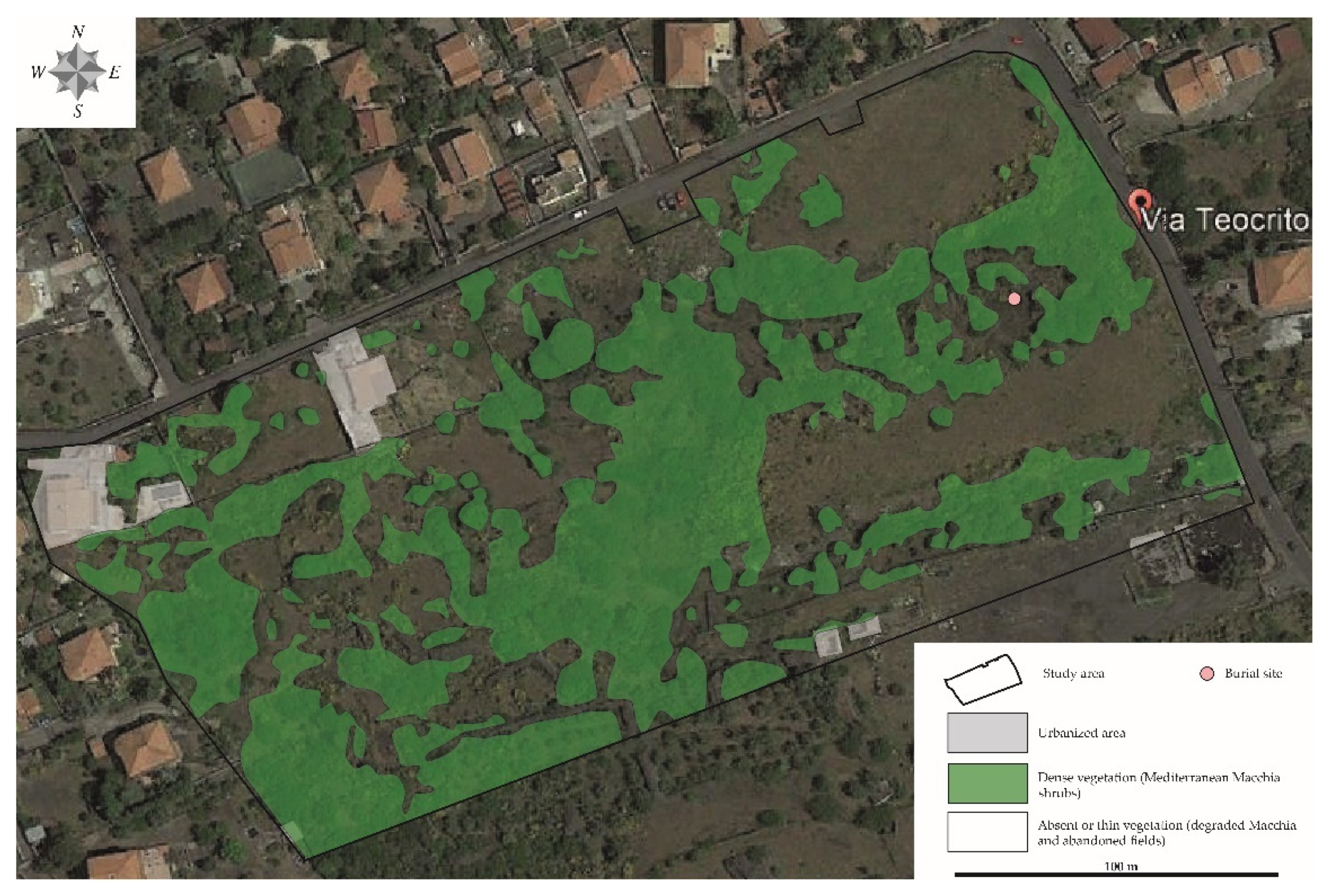
3.2.1. Geographical Background
3.2.2. Geological Background
3.2.3. Botanical Background
3.2.4. The Volcaniclastic Products
3.2.5. RAG Prioritization System
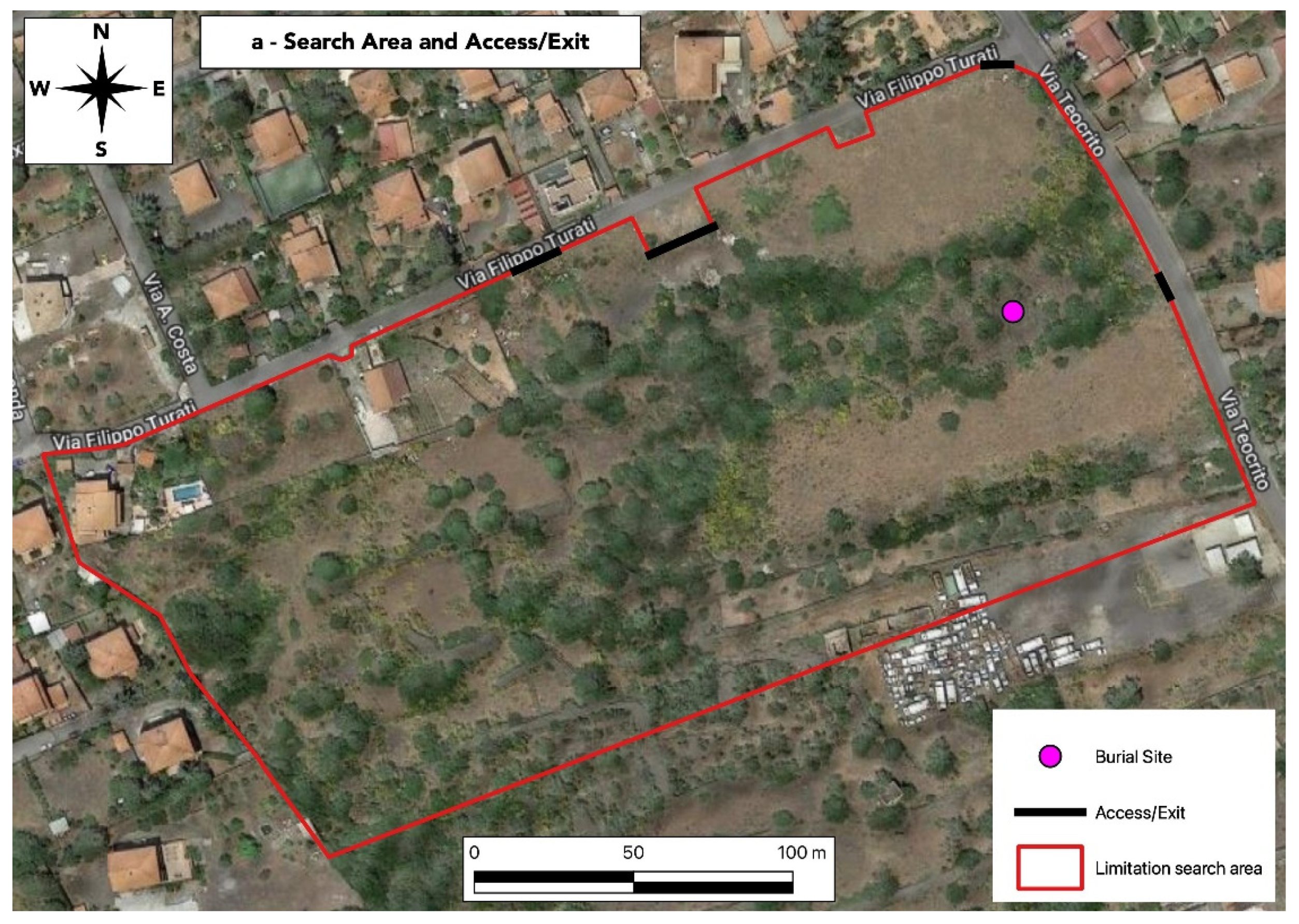
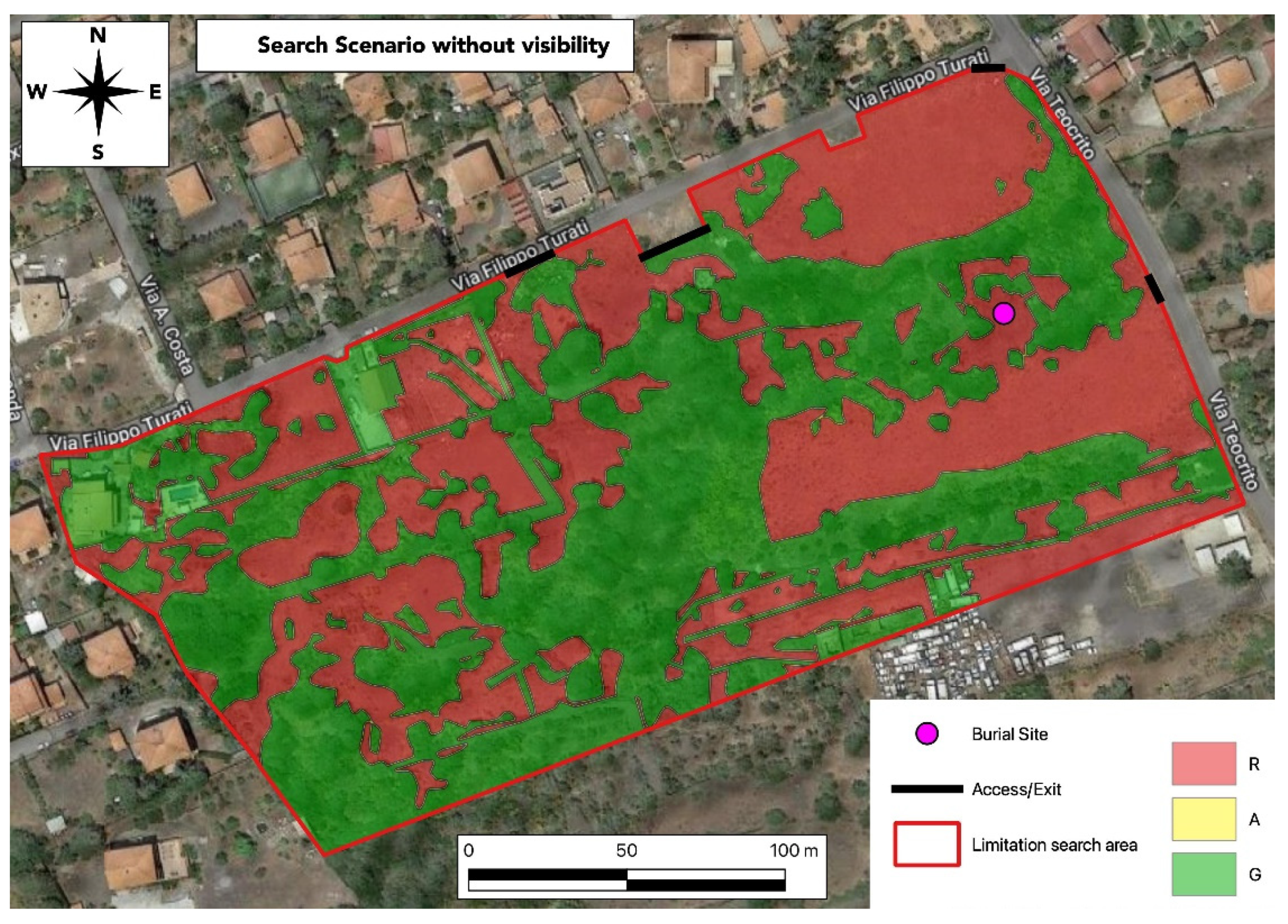
Limits and Exit-Entry Points of the Search Area
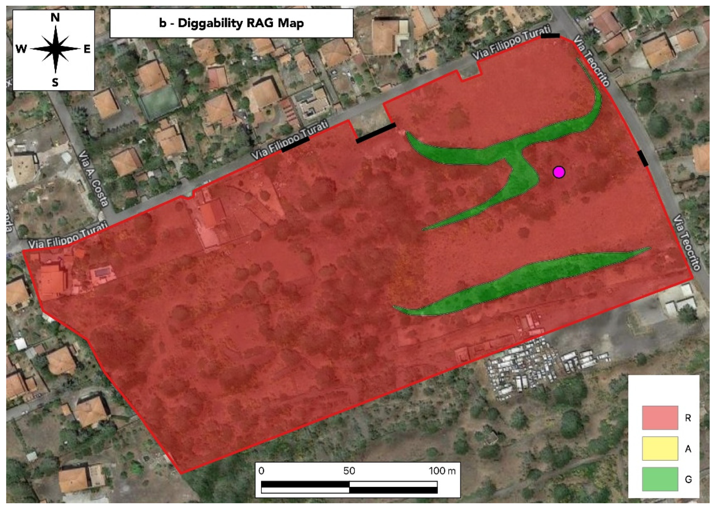
Diggability RAG Map
Landscape/Slope RAG Map
Vegetation RAG Map
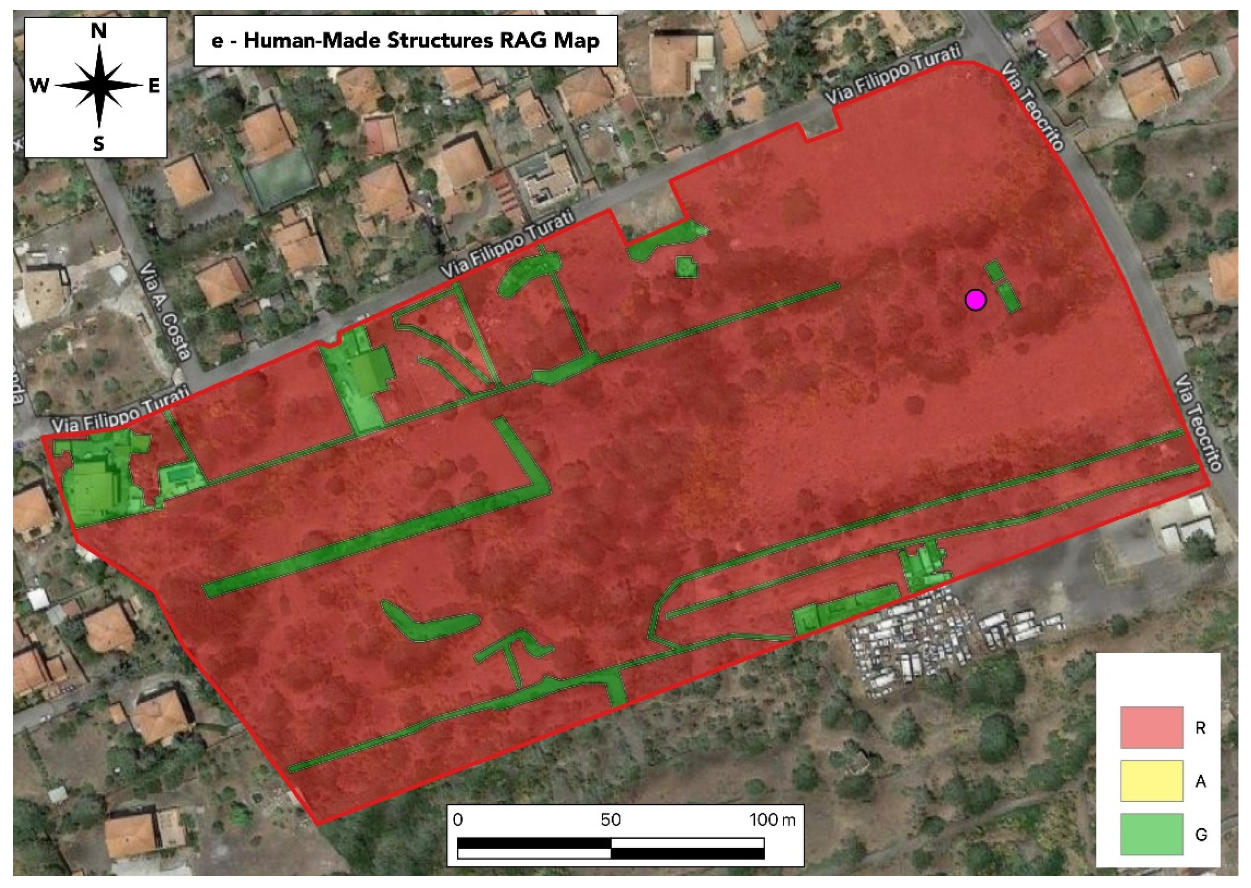
Human-Made Structures
Geomorphology RAG Map
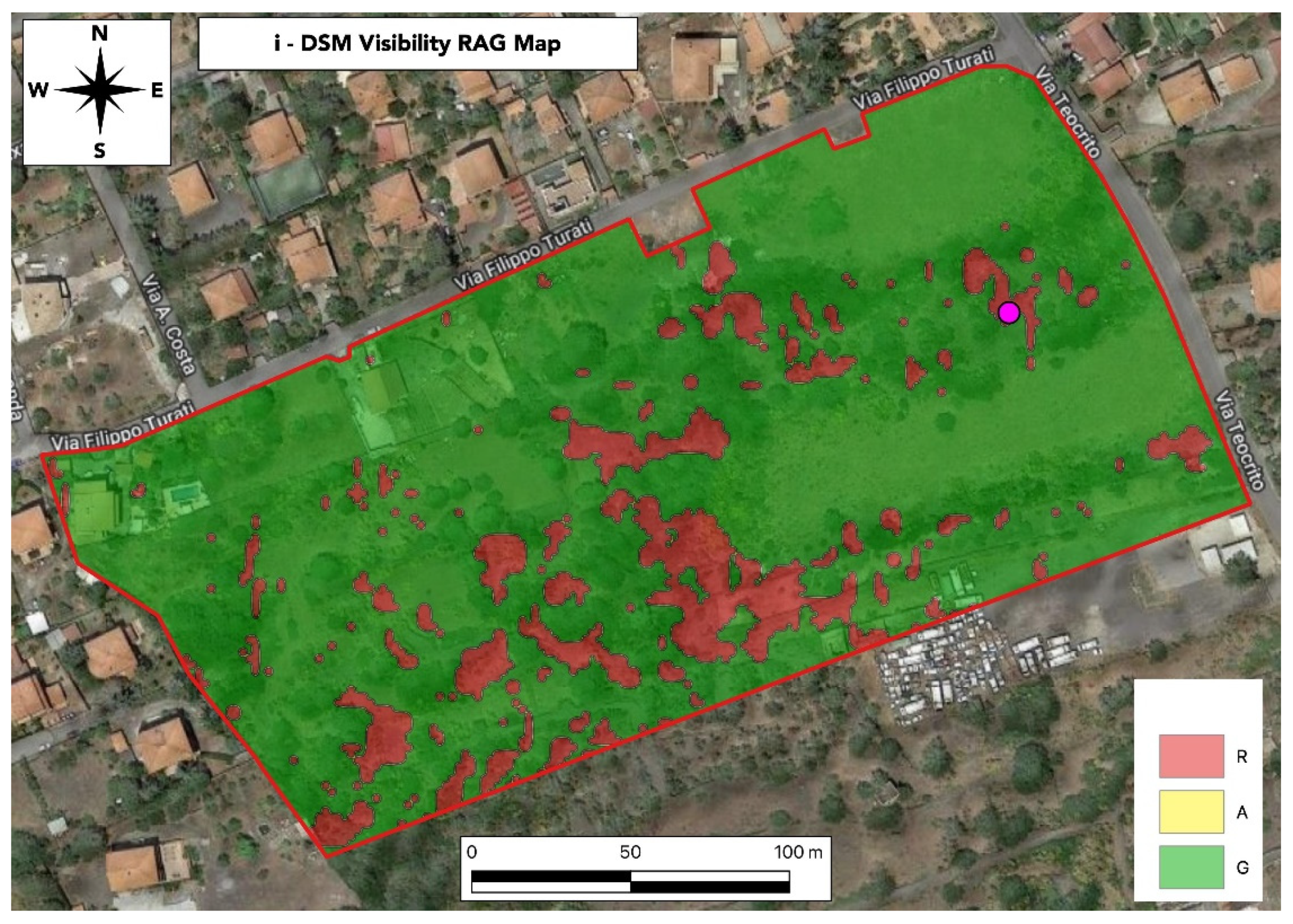
Visibility
Search Scenarios
4. Discussion
- The shape in plan view of the pits is usually elongated with an ellipsoidal, rectangular, or irregular shape.
- The ellipsoidal graves resemble on plan view a “foot” and are typical shapes of the pits dug in the underground with a spade/hoe and shovel as demonstrated by excavations realized in experimental excavations. The 3D shape of these ellipsoidal graves is peculiar and may resemble the shape of a “bathtub” showing three subvertical walls and one dipping towards the bottom. Experimental excavation demonstrated that in shallow burials, the sub-vertical walls are usually determined by the cut of the terrains made by a spade, pick, or hoe, whereas the gently dipping walls are usually determined by using a shovel in the act to move on the soil.
- The rectangular graves with sharp angles are typical shapes of the holes dug by mechanical excavators. The rectangular graves studied in most of the thirty graves show considerable depths and are compatible with 3D shapes similar to rectangular parallelograms obtained in the experimental excavations.
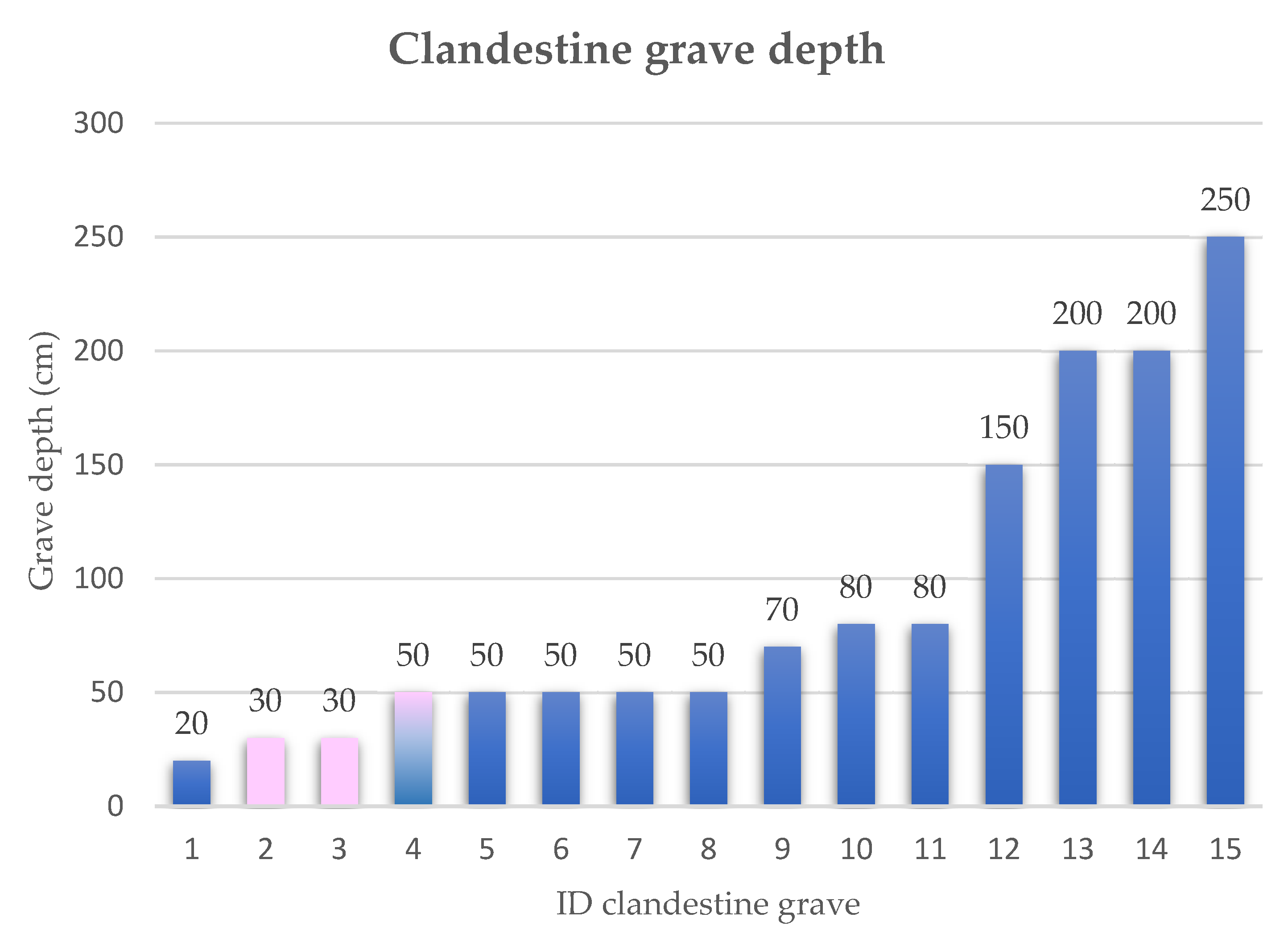
- The grave depth studied on fifteen graves (of the sample of thirty graves) results to range from 20–30 to 250 cm with an average value of 91 cm.
- Depths in the sample of thirty graves lower and higher than 150 cm generally indicate graves dug by hand with spade and shovel and by excavator, respectively.
- The 86% of the studied thirty graves was dug by men and only 14% was dug by women.
- The little available data on the graves dug by women indicate that the pits are very shallow, the depth reaches a medium value not exceeding 30 cm, and that used instruments are hand tools, such as spade, hoe, pick, and shovel.
5. Conclusions
Author Contributions
Funding
Institutional Review Board Statement
Acknowledgments
Conflicts of Interest
References
- Kamaluddin, M.R.; Mahat, N.A.; Mat Saat, G.A.; Othman, A.; Anthony, I.L.; Kumar, S.; Wahab, S.; Meyappan, S.; Rathakrishnan, B.; Ibrahim, F. The Psychology of Murder Concealment Acts. Int. J. Environ. Res. Public Health 2021, 18, 3113. [Google Scholar] [CrossRef] [PubMed]
- Commissari.gov.it. Commissario Straordinario Del Governo Per le Persone Scomparse. Report Primo Semestre 2022. Available online: https://commissari.gov.it/persone-scomparse/ (accessed on 1 August 2022).
- Storia in Network. Magazine di Divulgazione Storica. Available online: http://www.storiain.net/storia/il-delitto-matteotti/ (accessed on 1 July 2022).
- Repubblica.it. Venezia, è Stata Sepolta Viva la Ragazza Incinta al Nono Mese. 2006. Available online: http://www.repubblica.it/2006/05/sezioni/cronaca/ragazza-uccia-venezia/sepolta-viva/sepolta-viva.html (accessed on 2 July 2022).
- Quotidiano.net. Sotterra in Giardino la Madre Morta Confessa Solo Dopo Sette Anni. 2007. Available online: https://www.quotidiano.net/cronaca/2007/06/25/19310-sotterra_giardino_madre_morta.shtml (accessed on 3 July 2022).
- Unionesarda.it. Scheletro Trovato a Porto Pino. I Carabinieri Lanciano Appello Per Scoprire Identità. 2009. Available online: https://www.unionesarda.it/news-sardegna/scheletro-trovato-a-porto-pinoi-carabinieri-lanciano-appello-per-scoprire-identita-n5lc0qeb (accessed on 10 July 2016).
- Lastampa.it. Varese, Pusher di 17 Anni Ucciso e Sepolto in Giardino Dagli Amici. 2009. Available online: http://www1.lastampa.it/redazione/cmsSezioni/cronache/200904articoli/43106girata.asp (accessed on 11 July 2022).
- Repubblica.it. Bruino, il Corpo di Marina Patriti Trovato a Casa Crivellari. 2010. Available online: http://www.repubblica.it/cronaca/2010/11/07/news/torino_trovato_il_corpo_di_marina_patriti-8863907/ (accessed on 1 July 2022).
- Blitzquotidiano.it. Foggia: Si Scava Alla Ricerca Del Cadavere di Giuseppe Scopece, Scomparso Nel 2006. 2011. Available online: https://www.blitzquotidiano.it/cronaca-italia/foggia-cadavere-giuseppe-scopece-ricerche-748482/ (accessed on 5 July 2022).
- Torinotoday.it. Omicidio di Paolo Pilla a Rivalba: Il Perito Informatico Ucciso e Sepolto Nei Boschi. 2011. Available online: https://www.torinotoday.it/cronaca/morto-paolo-pilla-omicidio-rivalba.html (accessed on 5 July 2022).
- Laprovinciadisondrio.it. Omicidio Deiana, Sepolto in Cantina. La Cassazione Conferma: 22 Anni a Placido. 2022. Available online: https://www.laprovinciadisondrio.it/stories/premium/Cronaca/omicidio-deiana-sepolto-in-cantina-la-cassazione-conferma-22-anni-a-placid_1431943_11/ (accessed on 5 August 2022).
- Reggio.gazzettadelsud.it. Omicidio Pioli, il Caso è Chiuso. 2013. Available online: https://reggio.gazzettadelsud.it/articoli/archivio/2013/03/02/omicidio-pioli-il-caso-e-chiuso-4bdbef0a-ea26-45b9-b4e5-12d99e83404c/ (accessed on 10 July 2022).
- Bella, M. Livesicilia.it. Ucciso e Sepolto in un Agrumeto. Ritrovata L’auto Che Trasportò il Corpo. 2013. Available online: https://livesicilia.it/giallo-vadala-svolta-dopo-cinque-anniritrovata-lauto-con-cui-fu-trasportato-il-cadavere/ (accessed on 1 July 2022).
- Corrierefiorentino.it. Trovato il Corpo di Una Donna, Era Sepolto in Un Terreno. 2013. Available online: https://corrierefiorentino.corriere.it/firenze/notizie/cronaca/2013/28-novembre-2013/trovato-cadavere-una-donna-era-sepolto-un-terreno-2223717871269.shtml (accessed on 1 June 2022).
- Ilrestodelcarlino.it. Killer di Mozzate, Ritrovato il Cadavere di Silvio Mannina al Lago Azzurro. 2014. Available online: http://www.ilrestodelcarlino.it/rimini/cronaca/2014/04/24/1056920-omicidiomozzate-trovato-cadavere-mannina.shtml (accessed on 1 June 2022).
- Ilmessagero.it. Terni, lo Uccide e lo Seppellisce Nei Boschi: Forse Una Lite Fra Amanti Finita in Tragedia. 2014. Available online: http://www.ilmessaggero.it/umbria/terni_omicidio_stroncone_cadavere_assassino_scomparso_omosessualit_agrave-481181.html (accessed on 11 July 2022).
- Cronachemaceratesi.it. Pietro Sarchiè Ritrovato Morto, il Corpo Seppellito in Campagna. 2014. Available online: https://www.cronachemaceratesi.it/2014/07/05/ritrovato-pietro-sarchie-il-corpo-seppellito-in-campagna/548417/ (accessed on 5 July 2022).
- Palermotoday.it. Corleone, Nasconde la Morte di un Anziano Per Intascare la Pensione. 2014. Available online: http://www.palermotoday.it/cronaca/corleone-nasconde-morte-antonino-cutro.html (accessed on 5 July 2022).
- Ansa.it. Cadavere Nella Sabbia Identificato, Due Arresti. Due Persone Arrestate Per L’omicidio. 2014. Available online: https://www.ansa.it/piemonte/notizie/2014/08/08/cadavere-nella-sabbia-vittima-omicidio-scoperta-dopo-mesi_f28e687a-ecb4-4973-a684-e2c06322d913.html?fb_comment_id=671753772902957_671783832899951 (accessed on 5 July 2022).
- Pioppi, P. Ilgiorno.it. Omicidio di Guanzate: Colpito Con 50 Coltellate, Lasciato Morire Dissanguato e Seppellito Nel Giardino. 2014. Available online: http://www.ilgiorno.it/como/cronaca/omicidio-guanzate-ernestoalbanese-1.338984 (accessed on 1 June 2022).
- Varesenews.it. Ucciso e Sepolto, Fermato un Sospetto. 2014. Available online: https://www.varesenews.it/2014/02/ucciso-e-sepolto-fermato-un-sospetto/41427/ (accessed on 1 June 2022).
- Laprimapagina.it. Sirbu Victor Trovato Morto Nei Pressi Della Spiaggia a Tor San Lorenzo ad Ardea. 2015. Available online: https://www.laprimapagina.it/2015/02/08/sirbu-victor-trovato-morto-nei-pressi-della-spiaggia-tor-san-lorenzo-ad-ardea/ (accessed on 2 June 2022).
- Morra, B. Lastampa.it. Omicidio, le Confidenze Con il Fidanzato. 2016. Available online: https://www.lastampa.it/topnews/edizioni-locali/cuneo/2016/02/02/news/omicidio-le-confidenze-con-il-fidanzato-1.36558244/ (accessed on 2 June 2022).
- Di Costanzo, A. Napoli.repubblica.it. Napoli, Trovato un Diciottenne Scomparso. Ucciso Con Due Colpi di Pistola al Volto. Fermato un Amico. 2016. Available online: https://napoli.repubblica.it/cronaca/2016/02/19/news/napoli_trovato_sepolto_e_senza_vita_un_diciottenne_scomparso_da_due_settimane-133758388/ (accessed on 1 July 2022).
- Archivio.giornalettismo.com. Omicidio di Vincenzo Amendola: I Killer, il Selfie e il Bacio in Bocca. 2016. Available online: https://archivio.giornalettismo.com/omicidio-vincenzo-amendola-bacio-selfie/ (accessed on 9 August 2022).
- Del Porto, D. Napoli.repubblica.it. La Vera Storia di Giò, Eliminata Per un Rifiuto ai Narcos. Non Volle Mettersi in Affari Con Loro. 2016. Available online: https://napoli.repubblica.it/cronaca/2016/05/17/news/la_vera_storia_di_gio_eliminata_per_un_rifiuto_ai_narcos_non_volle_mettersi_in_affari_con_loro-139944536/ (accessed on 1 June 2022).
- Youtube.com. Declaraciones de el Culpable Confieso, en el Juicio Por el Crimen de la Peregrina. 2016. Available online: https://www.youtube.com/watch?v=PSFCkVCxY9g (accessed on 1 July 2022).
- Elpais.com. El Asesino de la Peregrina Denise Thiem Detalla en Primera Persona Como la Mato. 2016. Available online: https://elpais.com/politica/2016/06/23/actualidad/1466699640_988729.html (accessed on 24 June 2022).
- Laprovinciadivarese.it. Giallo di Casalzuigno È il Cadavere di Colombo. 2016. Available online: http://www.laprovinciadivarese.it/stories/Cronaca/giallo-di-casalzuigno-e-il-cadavere-di-colombo_1032732_11/ (accessed on 3 July 2022).
- Badcock, J. Telegraph.co.uk. Spanish Man Found Guilty of Murder after Beating US Pilgrim to Death and Chopping off Her Hands. 2017. Available online: https://www.telegraph.co.uk/news/2017/04/06/spanish-man-found-guilty-murder-beating-us-pilgrim-death-chopping/ (accessed on 7 April 2022).
- Di Caterino, M. Ilmattino.it. Camorra Pulp ad Afragola: Boss Fatti a Pezzi e Sepolti in Sacchi. 2017. Available online: http://www.ilmattino.it/napoli/cronaca/camorra_pulp_afragola_boss_fatti_a_pezzi_sepolti_in_sacchi-2264868.html (accessed on 1 July 2022).
- Cantoni, D. Milano.repubblica.it. Como, Identificato il Cadavere Ritrovato Nei Boschi: “Ucciso Con Due Colpi Alla Testa”. 2017. Available online: https://milano.repubblica.it/cronaca/2017/04/04/news/cadavere_boschi_como-162202162/ (accessed on 1 July 2022).
- Longo, E. Ilsussidiario.net. Neonato Trovato Morto in Giardino: Rintracciata Madre. Cirò, Badante Anziana Confessa. 2019. Available online: https://www.ilsussidiario.net/news/cronaca/2019/3/28/corpo-di-neonato-trovato-sepolto-in-un-giardino-ciro-ritrovamento-choc-e-giallo/1864830/ (accessed on 1 July 2022).
- Ravennanotizie.it. Omicidio di Faenza. Gli Investigatori Hanno Trovato la Buca Dove Doveva Essere Sepolta Ilenia, Secondo la Confessione di Barbieri. 2021. Available online: https://www.ravennanotizie.it/cronaca/2021/03/25/omicidio-di-faenza-gli-investigatori-hanno-trovato-la-buca-dove-doveva-essere-sepolta-ilenia-secondo-la-confessione-di-barbieri/ (accessed on 30 April 2021).
- Bresciatoday.it. Sepolta e Riemersa Dopo Settimane: Il Cadavere Ritrovato da un Bambino. Mistero Fitto Sul Ritrovamento Del Corpo. 2021. Available online: https://www.bresciatoday.it/cronaca/cadavere-laura-ziliani.html (accessed on 9 August 2021).
- Del Porto, D. Repubblica.it. Camorra, il Fantasma di Antonio Bardellino: Storia Del Boss Scomparso Nel Nulla. 2021. Available online: https://www.repubblica.it/dossier/cronaca/storie-di-mafia/2021/09/30/news/camorra_fantasma-319836223/ (accessed on 9 August 2022).
- Rodella, M. Corriere.it. Delitto Ziliani, i Verbali Choc: «Strozzata Con le Nostre Mani». Avevano Già Provato a Ucciderla. 2022. Available online: https://www.corriere.it/cronache/22_maggio_28/delitto-ziliani-verbali-choc-strozzata-le-nostre-mani-avevano-gia-provato-ucciderla-57101d2c-ddfb-11ec-9d2a-935eb68a8d83.shtml (accessed on 7 May 2022).
- Mediasetinfinity.mediaset.it. Ha Confessato Anche L’altra Figlia di Laura Ziliani. In Diretta Dalla Buca Scavata Dal Trio Per Seppellire Laura. 2022. Available online: https://mediasetinfinity.mediaset.it/video/pomeriggiocinque/ha-confessato-anche-laltra-figlia-di-laura-ziliani_F311274601170C01 (accessed on 27 May 2022).
- Vocecamuna.it. Temù: Dagli Atti Delle Indagini Emerge L’esistenza di Una Fossa Scavata Per Nascondere il Cadavere di Laura Ziliani. 2022. Available online: https://www.vocecamuna.it/temu-dagli-atti-delle-indagini-emerge-lesistenza-di-una-fossa-scavata-per-nascondere-il-cadavere-di-laura-ziliani/ (accessed on 25 May 2022).
- Ultimenotizieflash.com. I Macabri Dettagli Sull’omicidio di Laura Ziliani: Trovata Anche la Fossa Scavata per Occultare il Cadavere. 2022. Available online: https://www.ultimenotizieflash.com/cronaca/attualita-italiana/2022/05/30/i-macabri-dettagli-sullomicidio-di-laura-ziliani-trovata-anche-la-fossa-scavata-per-occultare-il-cadavere (accessed on 30 May 2022).
- Femminicidioitalia.info. Omicidio Viktorija Vovkotrub: Accoltellata a Sepolta in Una Buca. Chiesto L’ergastolo per L’ex Compagno Kadrus Berisa. 2022. Available online: https://femminicidioitalia.info/notizia/5129/brescia-omicidio-viktorija-vovkotrub-accoltellata-sepolta-in-una-buca-chiesto-ergastolo-per-ex-compagno-kadrus-berisa (accessed on 1 June 2022).
- Torino.repubblica.it. Jessica Lesto Trovata Morta in Una Buca ad Aosta, Ora la Polizia Cerca il Marito. 2022. Available online: https://torino.repubblica.it/cronaca/2022/06/02/news/jeccisa_lesto_trovata_morta_in_una_buca_ad_aosta_ora_la_polizia_cerca_il_marito-352222487/ (accessed on 30 June 2022).
- Greco, F. Agi.it. La Madre Della Piccola Elena ha Tentato di Nascondere il Corpo in Una Buca. 2022. Available online: https://www.agi.it/cronaca/video/2022-06-14/madre-piccola-elena-tentato-nascondere-corpo-buca-17094683/ (accessed on 14 June 2022).
- Chilhavisto.rai.it. Available online: http://www.chilhavisto.rai.it/dl/clv/index.html (accessed on 1 July 2022).
- Keatley, D.; O’Donnell, C.; Chapman, B.; Clarke, D.D. The Psycho-criminology of Burial Sites: Developing the Winthropping Method for Locating Clandestine Burial Sites. J. Police Crim. Psychol. 2022, 37, 91–100. [Google Scholar] [CrossRef]
- Canter, D. Mapping Murder: Walking in Killers’ Footsteps; Virgin Books Publishers: London, UK, 2003. [Google Scholar]
- Hirschfield, A.; Bowers, K. Mapping and Analysing Crime Data: Lessons from Research and Practice; CRC Press Publisher: New York, NY, USA, 2003. [Google Scholar]
- Somma, R.; Silvestro, M.; Cascio, M.; Dawson, L.; Donnelly, L.; Harrison, M. The use of a GIS Red-Amber-Green (RAG) system to define search priorities for burials. In Proceedings of the 2016 European Geosciences Union EGU General Assembly, Vienna, Austria, 17–22 April 2016. [Google Scholar]
- Somma, R.; Cascio, M.; Silvestro, M.; Torre, E. A GIS-based quantitative approach for the search of clandestine graves, Italy. J. Forensic Sci. 2018, 63, 882–898. [Google Scholar] [CrossRef] [PubMed]
- Pizzichi, A. Auralcrave.com. L’illusione Della Libertà: Robert Hansen, il Cacciatore di Esseri Umani. 2022. Available online: https://auralcrave.com/2022/02/23/lillusione-della-liberta-robert-hansen-il-cacciatore-di-esseri-umani/ (accessed on 1 March 2022).
- Lelandhale.com. Butcher Baker. True Crime in Alaska. Robert Hansen Killed, Buried Women along the Knik. 2017. Available online: https://lelandhale.com/butcherbaker/wordpress/2017/09/08/robert-hansen-graves-along-knik/ (accessed on 1 March 2022).
- Donnelly, L.; Harrison, M. Geomorphological and geoforensic interpretation of maps, aerial imagery, conditions of diggability and the colour-coded RAG prioritization system in searches for criminal burials. Geol. Soc. Lond. Spec. Publ. 2013, 384, 173–194. [Google Scholar] [CrossRef]
- France, D.L.; Griffin, T.J.; Swanburg, J.G.; Lindemann, J.W.; Davenport, G.C.; Trammell, V. Necrosearch revisited: Further multidisciplinary approaches to the detection of clandestine graves. In Forensic Taphonomy: The Postmortem Fate of Human Remains; Haglund, W.D., Sorg, M.H., Eds.; CRC Press Publisher: New York, NY, USA, 1997; pp. 497–509. [Google Scholar]
- Ruffell, A. Burial location using cheap and reliable quantitative probe measurements. Diversity in forensic anthropology. Spec. Publ. Forensic Sci. Int. 2004, 151, 207–211. [Google Scholar] [CrossRef]
- Ruffell, A.; McKinley, J. Forensic geoscience: Applications of geology, geomorphology and geophysics to criminal investigations. Earth-Sci. Rev. 2005, 69, 235–247. [Google Scholar] [CrossRef]
- Brown, A.G. The use of forensic botany and geology in war crimes investigations in NE Bosnia. Forensic Sci. Int. 2006, 163, 204–210. [Google Scholar] [CrossRef]
- Salsarola, D.; Cattaneo, C. Archeologia forense. In Scienze Forensi—Teoria E Prassi Dell’investigazione Scientifica; Intini, A., Picozzi, M., Eds.; UTET Giuridica Publisher: Milano, Italy, 2009; pp. 207–226. [Google Scholar]
- Byrd, J.B.; Castner, L. Forensic Entomology: The Utility of Arthropods in Legal Investigations, 2nd ed.; CRC Press Publisher: New York, NY, USA, 2009. [Google Scholar]
- Pringle, J.K.; Jervis, J.R. Electrical resistivity survey to search for a recent clandestine burial of a homicide victim, UK. Forensic Sci. Int. 2010, 202, 1–7. [Google Scholar] [CrossRef]
- Harrison, M. Grave concerns, locating and unearthing human bodies. Aust. J. Forensic Sci. 2011, 43, 324–325. [Google Scholar] [CrossRef]
- Larson, D.O.; Vass, A.A.; Wise, M. Advanced scientific methods and procedures in the forensic investigation of clandestine graves. J. Contemp. Crim. Justice 2011, 27, 149–182. [Google Scholar] [CrossRef]
- Pringle, J.K.; Ruffell, A.; Jervis, J.R.; Donnelly, L.; McKinley, J.; Hansen, J. The use of geoscience methods for terrestrial forensic searches. Earth-Sci. Rev. 2012, 114, 108–123. [Google Scholar] [CrossRef]
- Ruffell, A.; Pringle, J.K.; Cassella, J.P.; Morgan, R.M.; Ferguson, M.; Heaton, V.G.; McKinley, J.M. The use of geoscience methods for aquatic forensic searches. Earth-Sci. Rev. 2017, 171, 323–337. [Google Scholar] [CrossRef]
- Sagripanti, G.L.; Villalba, D.; Aguilera, D.; Giaccardi, A. Advances of forensic geology in Argentina: Search with non-invasive methods for victims of enforced disappearance. Boletin Geol. 2017, 39, 55–69. [Google Scholar] [CrossRef][Green Version]
- Rocke, B.; Ruffell, A.; Donnelly, L. Drone aerial imagery for the simulation of a neonate burial based on the geoforensic search strategy. J. Forensic Sci. 2021, 66, 1506–1519. [Google Scholar] [CrossRef]
- Ruffell, A.; Barry, L. The desktop study-an essential element of Geoforensic search: Homicide and environmental cases (West Belfast, Northern Ireland, UK). Geol. Soc. Spec. Publ. 2021, 492, 39–53. [Google Scholar] [CrossRef]
- Rocke, B.; Ruffell, A. Detection of Single Burials Using Multispectral Drone Data: Three Case Studies. J. Forensic Sci. 2022, 2, 72–87. [Google Scholar] [CrossRef]
- Murray, R.C.; Tedrow, J.C. Forensic Geology: Earth Sciences and Criminal Investigation; Rutgers University Press Address: New Brunswick, NJ, USA, 1975; pp. 1–232. [Google Scholar]
- Tindall, C.G. Forensic Geology. Soil Sci. 1994, 157, 128. [Google Scholar] [CrossRef]
- Murray, R.C. Evidence from the Earth: Forensic Geology and Criminal Investigation; Mountain Press Publishing Company: Missoula, MT, USA, 2004; pp. 1–226. [Google Scholar]
- Murray, R.C. Forensic geology: Yesterday, today and tomorrow. Geol. Soc. Spec. Publ. 2004, 232, 7–9. [Google Scholar] [CrossRef]
- Pye, K. Forensic geology. In Encyclopedia of Geology; Selley, R.C., Cocks, L.R.M., Plimer, I.R., Eds.; Elsevier Ltd.: Oxford, UK, 2005; Volume 2, pp. 261–273. [Google Scholar]
- Bull, P.A.; Morgan, R.M. Sediment fingerprints: A forensic technique using quartz sand grains. Sci. Justice 2006, 46, 64–68. [Google Scholar] [CrossRef]
- Pye, K. Geological and Soil Evidence, 1st ed.; CRC Press: Boca Raton, FL, USA, 2007; pp. 1–356. [Google Scholar] [CrossRef]
- Ruffell, A.; McKinley, J. Geoforensics; John Wiley & Sons Ltd.: Chichester, UK, 2008; pp. 1–332. [Google Scholar]
- Ruffell, A. Forensic pedology, forensic geology, forensic geoscience, geoforensics and soil forensics. Forensic Sci. Int. 2010, 202, 9–12. [Google Scholar] [CrossRef]
- Donnelly, L.J.; Pirrie, D.; Harrison, M.; Ruffell, A.; Dawson, L.A. A Guide to Forensic Geology, 1st ed.; Geological Society of London: London, UK, 2021; pp. 1–217. [Google Scholar]
- Fitzpatrick, R.W.; Donnelly, L.J. An introduction to forensic soil science and forensic geology: A synthesis. Geol. Soc. Spec. Publ. 2021, 492, 1–32. [Google Scholar] [CrossRef]
- Somma, R. Advances in Flipped Classrooms for Teaching and Learning Forensic Geology. Educ. Sci. 2022, 12, 403. [Google Scholar] [CrossRef]
- Doyle, P.; Bennett, M.R. Military geography: Terrain evaluation and the British Western Front 1914–1918. Geogr. J. 1997, 163, 1–24. [Google Scholar] [CrossRef]
- Ruffell, A.; McAllister, S. A RAG system for the management forensic and archaeological searches of burial grounds. Int. J. Archaeol. 2015, 3, 1–8. [Google Scholar] [CrossRef]
- Davenport, G.C. Remote sensing applications in forensic investigations. Hist. Archaeol. 2001, 35, 87–100. [Google Scholar] [CrossRef]
- Ruffell, A. Remote detection and identification of organic remains. Archaeol. Prospect. 2002, 9, 115–122. [Google Scholar] [CrossRef]
- Valenti, M.; Nardini, A. Modello dei dati e trattamento del dato sul GIS di scavo. Archeol. Calc. 2004, 15, 341–358. [Google Scholar]
- Manhein, M.H.; Listi, G.A.; Leitner, M. The application of geographic information systems and spatial analysis to assess dumped and subsequently scattered human remains. J. Forensic Sci. 2006, 51, 469–474. [Google Scholar] [CrossRef]
- Brown, K.M.; Keppel, R.D. Child abduction murder: An analysis of the effect of time and distance separation between murder incident sites on solvability. J. Forensic Sci. 2007, 52, 137–145. [Google Scholar] [CrossRef]
- Herrmann, N.P.; Devlin, J.B. Assessment of commingled human remains using a GIS-based approach. In Recovery, Analysis, and Identification of Commingled Human Remains; Adams, B.J., Byrd, J.E., Eds.; Humana Press Publisher: Totowa, NJ, USA, 2008; pp. 257–270. [Google Scholar]
- Wolff, M.; Asche, H. Towards geovisual analysis of crime scenes—A 3D crime mapping approach. In Advances in GIScienc; Sester, M., Bernard, L., Paelke, V., Eds.; Springer-Verlag Publisher: Berlin/Heidelberg, Germany, 2009; pp. 429–448. [Google Scholar]
- Elmes, G.A.; Roedl, G.; Conley, J. Forensic GIS: The Role of Geospatial Technologies for Investigating Crime and Providing Evidence; Springer Press Publisher: Dordrecht, The Netherlands, 2014; pp. 1–320. [Google Scholar]
- Bunch, A.W.; Kim, M.; Brunelli, R. Under our nose: The use of GIS technology and case notes to focus search efforts. J. Forensic Sci. 2017, 62, 92–98. [Google Scholar] [CrossRef]
- López Batista, M.; Rodríguez López, S.; Fieguth Batista, A. The Use of GIS in Forensic Archaeology to Search Clandestine Graves in Uruguay. Sci. Technol. Archaeol. Res. 2018, 2, 61–74. [Google Scholar] [CrossRef]
- Palazzo, S. Ilsussidiario.net. “Elena Del Pozzo Non è Morta Subito”/ L’autopsia: “Più di 11 Coltellate, Una Letale…”. 2022. Available online: https://www.ilsussidiario.net/news/elena-del-pozzo-non-e-morta-subito-lautopsia-piu-di-11-coltellate-una-letale/2361175/ (accessed on 18 June 2022).
- Iltempo.it. Elena Del Pozzo Uccisa Dalla Madre, i Carabinieri Raccontano la Confessione: “Come se Non si Fosse Resa Conto Del Gesto”. 2022. Available online: https://www.iltempo.it/attualita/2022/06/14/video/elena-del-pozzo-uccisa-dalla-madre-movente-conferenza-carabinieri-video-32013337/ (accessed on 14 June 2022).
- Youtube.com. Elena Del Pozzo Uccisa a Catania, i Carabinieri: «Si Indaga Sul Luogo Del Delitto». Available online: https://www.youtube.com/watch?v=dI_zQPfM3AE (accessed on 15 June 2022).
- Youtube.com. Catania, Elena Del Pozzo è Morta Per Mano Della Madre. 2022. Available online: https://www.youtube.com/watch?v=SHPFl3EGvVw (accessed on 17 June 2022).
- Iltempo.it. Elena Del Pozzo Uccisa e Sepolta in un Campo: Il Ritrovamento Del Cadavere. Available online: https://www.iltempo.it/attualita/2022/06/14/video/elena-del-pozzo-ritrovato-cadavere-bimba-mascalucia-campo-video-32013850/ (accessed on 14 June 2022).
- Fanpage.it. Confessa la Mamma di Elena Del Pozzo, L’ha Uccisa Dopo L’asilo: “Gelosia Possibile Movente”. 2022. Available online: https://www.youtube.com/watch?v=WMLM9lTGvqs (accessed on 14 June 2022).
- Fanpage.it. Omicidio Elena Del Pozzo: “La madre si è Procurata Una Zappa e Una Pala Per Occultare il Cadavere”. 2022. Available online: https://www.youtube.com/watch?v=d6gY-IsKLhw (accessed on 15 June 2022).
- Youtube.com. Mascalucia, il Luogo Del Ritrovamento Visto Dall’alto. 2022. Available online: https://www.youtube.com/watch?v=HmWfSZo5Sbo (accessed on 14 June 2022).
- Siciliaunonews.com. Mascalucia, Bimba Morta. La madre: “L’ho Uccisa Girata, Non Volevo Guardarla”. 2022. Available online: http://www.siciliaunonews.com/2022/06/mascalucia-bimba-uccisa-dalla-madre.html (accessed on 21 June 2022).
- Direttasicilia.it. Elena Uccisa a Coltellate e Sepolta, la Madre Aveva Comprato Pala e Zappa. 2022. Available online: https://www.direttasicilia.it/2022/06/15/elena-uccisa-a-coltellate-e-sepolta-la-madre-aveva-comprato-pala-e-zappa/ (accessed on 15 June 2022).
- Agi.it; Greco, F.; Bruno, N. La Notte Sotto L’etna di Elena, Uccisa Dalla Madre. 2022. Available online: https://www.agi.it/cronaca/news/2022-06-14/trovata-morta-bambina-rapita-catanese-17089667/ (accessed on 14 June 2022).
- Agi.it. Una Bimba di 5 Anni è Stata Sequestrata Nel Catanese da Persone Armate. 2022. Available online: https://www.agi.it/cronaca/news/2022-06-13/bambina-sequestata-catanese-17084057/ (accessed on 14 June 2022).
- Baiadellaconoscenza.com. Available online: https://baiadellaconoscenza.com/dati/argomento/read/19546-come-scavare-una-buca-velocemente (accessed on 1 August 2022).
- Balkanplumbing.com. How to Dig a Hole with a Shovel: Get Expert Advice from this Article & Video. 2021. Available online: https://www.balkanplumbing.com/how-to-dig-a-hole-with-a-shovel/ (accessed on 1 March 2021).
- Douglas, J.E.; Burgess, A.W.; Burgess, A.G.; Ressler, R.K. Crime Classification Manual: A Standard System for Investigating and Classifying Violent Crimes, 2nd ed.; Jossey-Bass, Wiley Imprint: Hoboken, NJ, USA, 2006; pp. 1–555. [Google Scholar]
- Mostrodifirenze.com. Mostro di Firenze—Monster of Florence. Un Caso Ancora Aperto. 11 June 1990 Perquisizione Cella e Proprietà di Pietro Pacciani. Available online: https://www.mostrodifirenze.com/1990/06/11/11-giugno-1990-perquisizione-cella-e-proprieta-di-pietro-pacciani/ (accessed on 2 January 2022).
- Manieri, E. Mostro-di-firenze.blogspot.com. Processo Pacciani: “Mercatale un Sogno di Fantascienza 10/4/1985”. Available online: https://mostro-di-firenze.blogspot.com/2009/08/pacciani-mercatale-sogno-di-fatascienza.html (accessed on 2 January 2022).
- Branca, S.; Coltelli, M.; Groppelli, G.; Pasquarè, G. Note Illustrative Della Carta Geologica D’italia Alla Scala 1:50.000 Foglio 625 Acireale; CNR, Ati-Selca: Florence, Italy, 2009; pp. 1–242. [Google Scholar]
- Carbone, S.; Branca, S.; Lentini, F. Note Illustrative Della Carta Geologica D’italia Alla Scala 1:50.000 Foglio 634 Catania; Università di Catania: Florence, Italy, 2009; pp. 1–168. [Google Scholar]
- Tanguy, J.C.; Le Goff, M.; Principe, C.; Arrighi, S.; Chillemi, V.; Paiotti, A.; La Delfa, S.; Patanè, G. Archeomagnetic dating of Mediterranean volcanics of the last 2100 years: Validity and limits. Earth Planet. Sci. Lett. 2003, 211, 111–124. [Google Scholar] [CrossRef]


Publisher’s Note: MDPI stays neutral with regard to jurisdictional claims in published maps and institutional affiliations. |
© 2022 by the authors. Licensee MDPI, Basel, Switzerland. This article is an open access article distributed under the terms and conditions of the Creative Commons Attribution (CC BY) license (https://creativecommons.org/licenses/by/4.0/).
Share and Cite
Somma, R.; Costa, N. Unraveling Crimes with Geology: As Geological and Geographical Evidence Related to Clandestine Graves May Assist the Judicial System. Geosciences 2022, 12, 339. https://doi.org/10.3390/geosciences12090339
Somma R, Costa N. Unraveling Crimes with Geology: As Geological and Geographical Evidence Related to Clandestine Graves May Assist the Judicial System. Geosciences. 2022; 12(9):339. https://doi.org/10.3390/geosciences12090339
Chicago/Turabian StyleSomma, Roberta, and Nunzio Costa. 2022. "Unraveling Crimes with Geology: As Geological and Geographical Evidence Related to Clandestine Graves May Assist the Judicial System" Geosciences 12, no. 9: 339. https://doi.org/10.3390/geosciences12090339
APA StyleSomma, R., & Costa, N. (2022). Unraveling Crimes with Geology: As Geological and Geographical Evidence Related to Clandestine Graves May Assist the Judicial System. Geosciences, 12(9), 339. https://doi.org/10.3390/geosciences12090339