Article

Reappraisal of Data of Hydrological Changes Associated with Some Strong Historical Italian Earthquakes

Istituto Nazionale di Geofisica e Vulcanologia, 00143 Rome, Italy
*
Author to whom correspondence should be addressed.
Geosciences 2023, 13(2), 55; https://doi.org/10.3390/geosciences13020055
Submission received: 21 October 2022 / Revised: 3 February 2023 / Accepted: 7 February 2023 / Published: 10 February 2023
(This article belongs to the Special Issue Modern Perspectives in Historical Seismology)

Abstract

:
Historical seismology retrieves information about the effects of earthquakes that occurred in the past, mostly regarding the damage, but also on environmental effects. In this paper, we describe the methodology of our research on earthquake-induced hydrological effects, which have been long observed and documented, and are among the most outstanding coseismic phenomena. The method of research follows two distinct paths, depending on whether the investigated event occurred before or after the end of the 18th Century. For the most ancient events, we present examples of historical accounts, local reports, private letters, and diaries, in which the information of interest is often hidden within broader descriptions and mentioned as a minor curiosity. On the contrary, for more recent earthquakes, the research benefits from the growing interest in naturalistic observations that marked the onset of the 19th Century, and is achieved through detailed descriptions, journals, seismic postcards, and through the first systematic collections of instrumental data. Finally, we describe a possible method of classification of the hydrological data and show an analysis of the potential applications and outcomes of this type of research.

Graphical Abstract

1. Introduction

The main commitment of historical seismology is to expand the knowledge of seismicity as far back as possible. To this aim, investigators working in this branch of seismology retrieve information regarding the effects of earthquakes that occurred in pre-instrumental times (until about the first half of the 20th Century) to provide seismological parameters for the compilation of the seismic long-term earthquakes’ catalogs [1,2,3,4,5]. Traditionally, historical seismology has been mainly dedicated to the finding of information regarding the damage of buildings and/or the effects on people [6,7,8], allowing for the estimation of the intensity of an earthquake with macroseismic methods. However, historical research on ancient seismic events even allows for the retrieval of information different from the damage statistics, such as the geomorphological, geological, and hydrological effects. Starting in the late 18th Century, a renewed interest in the occurrence of natural phenomena encouraged a number of scientists and observers to travel to areas stricken by a severe seismic event to investigate the causes of the earthquake and document its effects.
One of these interesting examples was represented by an ante litteram macroseismic questionnaire drawn by the geologist Giacomo Paci, retrieved from the National Archive of Naples [9]. The document deals with a request, put forward by the Central Authorities, for information and data regarding some earthquakes that had been felt in Calabria (Southern Italy). To gather statistical observations regarding earthquake effects, the questionnaire formulated several questions, including “sonosi osservate screpolature del suolo ed uscirne mofete?” (transl. Did you observe ground rupturing and emission of mofette?) and “vi è stata alterazione nel corso delle acque dei fiumi, e dei ruscelli, ed in quelle dei pozzi?” (transl. Did you observe any variations in the flow of rivers or streams, and in the level of wells?).
Not surprisingly, the observations of natural effects were thus included in the diagnostic lists of the macroseismic scales formulated during the first half of the 20th Century [10,11,12,13], and contribute to the definition of the Environmental Seismic Intensity scale (ESI), which was established at the beginning of the 21st Century and only assesses intensity by the use of such effects [14]. The present legacy of the activity of environmental effects collection are accurate and detailed coeval reports, which are now available to modern investigators (e.g., [15,16,17,18,19], and for only some of the strongest earthquakes that occurred in Italy). The observations retrieved from those reports represent the starting point of studies dedicated to seismotectonic analyses [20,21,22,23,24,25,26,27], to hazard estimates [28,29], or to the compilation of specific catalogs [23,28,30,31,32,33]. In particular, hydrological effects created by earthquakes have long been observed and documented, as they are among the most outstanding coseismic phenomena and can be observed over great distances [34,35]. Examples include increases or decreases in streamflow, variations in the water levels in wells, formation and/or disappearance of springs and changes in their discharge, and changes in the chemical/physical characteristics of waters. In the last decades the character of the coseismic hydrological changes has often been found to be related to the style of faulting [35,36,37,38]; in this way, the contribution of historical data of earthquake-induced hydrological changes have provided clues and constraints in discriminating between the causative faults of strong seismic events [24,25,39,40]. Therefore, in this paper, we focus on the hydrological changes originated by some historical earthquakes that have occurred in Central-Southern Italy (Figure 1) through: (i) the description of the methodologies of data retrieval; (ii) the classification of the data; (iii) an analysis of the potential applications and outcomes.

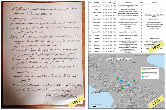
2. Materials and Methods

Similar to traditional research on historical seismology, the data retrieval of earthquake-induced hydrological effects becomes more difficult the further one goes back in time. Unlike the information used to estimate macroseismic intensity (mostly data on damage), observations on the hydrological effects are rarely subject to systematic collection (for very recent earthquakes, the situation is different; see the end of this section). Therefore, the research method differs depending on whether the object of the investigation is an ancient or a modern earthquake.
  • ‘ancient’ earthquakes (~1600–~end of 18th Century)
Information on hydrological changes caused by earthquakes that occurred up until the second half of the 18th Century (Figure 2) is essentially qualitative and very difficult to retrieve. This kind of information is often ‘hidden’ in a variety of reports such as: chronicles, private letters and diaries, and local reports. For most of them, the event is mentioned as a minor curiosity and is eventually not even referred to individual earthquakes.
Infrequent sources of data derive from administrative correspondence between citizens and institutions for compensation claims, which are preserved in repositories and public archives (Figure 3).
Towards the end of the 18th Century, the first examples of proto-maps and sketches appear, reporting generic annotations of hydrological evidence, as a tread of the more detailed observations and images produced in the next few decades (Figure 4).
  • ‘modern’ earthquakes (~end of 18th Century—1950)
For seismic events that have occurred in the past couple of centuries, research has usually benefitted from the growing interest in naturalistic observations by scholars, who, especially in the period from ~1800 to the first half of the 1900s, collected and classified effects observed in conjunction with earthquakes. These types of observations include—besides the damage—atmospheric phenomena, the behavior of animals, geomorphological modifications, and variations in hydrological regimes (streamflow discharge, springs, wells, liquefactions) e.g., [45,46].
This information, at times with no quantitative elements, is often found mixed and superimposed within generic studies on seismic events. Two large magnitude seismic events mark the divide of this renewed interest, the 1783 M = 7.1 Southern Calabria and the 1805 M = 6.7 Central Italy earthquakes. For the first time, several travel diaries, consistent between the coeval investigators, reported a great number of pre-, co-, and post-seismic hydrological observations clearly associated with the occurrence of the events [15,16,31,42,43,47,48,49,50,51] (Figure 5).
In particular, the detailed engravings and drawings produced by the members of the expedition sent to the 1783 epicentral area on behalf of the Kingdom of Naples (Figure 6) represent a faithful picture of the effects observed in the field, exploited in different studies still today [21,25].
The reports following the 1805 earthquake, which struck the Central-Southern Apennines after a one-century-long period of relative seismic quiescence [41], confirm this ‘new age’ of scientific interest, with unprecedented detailed descriptions of hydrological effects (Figure 7) [16,50,51].
Starting from the second half of the 18th Century, an increasing set of data on earthquake-induced hydrological effects was provided by local and national newspapers, which started a frequent and widespread coverage of the news coming from the territory (Figure 8). The descriptions are more detailed and revealing of the nature of the effects.
The last decades of the 18th Century saw the onset of new means of data retrieval, i.e., seismic postcards and, later, the macroseismic questionnaires, which provided thousands of data on earthquake effects that allowed a systematic and modern approach to earthquake studies. In particular, the seismic postcards (synthetic, standard reports of intensity from selected correspondents like municipalities, post offices, and police agencies that were collected until the end of the next century), explicitly ask the compiler for information about hydrological effects (Figure 9).
The last important branch of data retrieval comes from the aqueducts service and from the ‘Annali Idrologici’ (Hydrologic Annals), that provide regular and frequent observations and measures of the discharge of rivers and springs, of the level in wells, as well as a daily bulletin on rainfall. The Annali Idrologici have provided information since the 1920s, and are a sound and quantitative support to the collection of hydrological data associated with earthquakes (Figure 10), also in present times.
Aside from historical seismology, during the most recent decades, the observations of earthquake-induced hydrological effects have become a subject of systematic collection. Though, from a qualitative point of view, the information that is collected has not changed through the centuries, today, modern instruments and methods of recording provide data that is routinely used in different studies (e.g., [38,52,53,54,55,56,57,58]). As an example, an accurate survey of old and new datasets allows us to contribute to the study on the nature and role of fluids in the seismogenic processes and for hazard estimation, i.e., areas prone to liquefaction phenomena [59].

Classification of Data

Once the observations of earthquake-induced hydrological changes have been collected, there is the need to organize the data and to supply information and parameters to provide comprehensible access to scientists and other users, i.e., to envision the format and build up the final structure of folders and files for the storage of data and sources. The classification scheme we show in the following has been realized within the activities of the Project Further (The role of FlUids in the pReparaTory pHase of EaRthquakes in Southern Apennines) the aim of which is to explore, through multidisciplinary methods, the role of fluids in the different phases of the earthquake occurrence. Observational data coming from historical sources and from the literature are filed by earthquake, for which hydrological changes have been observed.
Within the abovementioned project, each study event is marked by a single folder, in which the fundamental product is the database of hydrological observations (Figure 11). Each observation is accurately reconsidered and localized, cross-checking the original description with topographic maps at different scales. In addition to the location and the geographical coordinates of the observation, we also report the epicentral distance from the seismic event and the most detailed description of the type of evidence of the hydrological effect, including some complementary notes by the compiler that provide further information about the reliability of the observation. The field ‘References’ in the database reports all of the sources that contributed to the fulfillment of the record. Based on the reliability of each reference/account, a three-fold quality code (A/B/C) is assigned to the data. The best rank ‘A’ is assigned to the observations that were clearly described and consistently reported by coeval investigators; second and third ranking is given to observations not clearly described or with tenuous evidence (‘B’), or mislocated and/or doubtfully associated with the event (‘C’). Needless to add, the oldest data are those with the lowest reliability, but, being the rarest, they are also the most valuable.
In addition to the database of the observations, the folder associated with each event includes a sub-folder containing the original documents that were accessed and a text file for references, the bibliography, and transcriptions of all the information that was retrieved by the sources.

3. Results and Discussion

Databases of observations of earthquake-induced effects (both geomorphological and hydrological effects) are the first and most necessary outcome of the activity of data retrieval. Several databases exist of this type for the Italian territory, some all-embracing different types of observations [23,30,31], others dedicated to a single type of evidence (for instance, liquefaction: [28,32]). In addition to the database of the observations, the basic outcomes of this activity are maps of hydrological changes. As an example, we show the map of the earthquake-induced hydrological variations—obtained after research carried out within the Further Project—associated with the 1688 M = 7.1 Sannio seismic event (Figure 12; original dataset in Figure 11).
Considering that the most recent compilation of earthquake-induced effects in Italy [23,30,31] counts eleven observations relative to six locations for this event, it is worth noting that in-depth research allowed us to retrieve almost twenty data associated with nine different localities, which is a remarkable result given the very old age of occurrence of the earthquake.
Furthermore, in-depth research of earthquake-induced effects can provide scientific papers focused on individual, remarkable seismic events. These papers represent a fundamental input to update and implement databases. Table 1 shows a list of scientific papers that reported on earthquake-induced hydrological effects associated with the largest historical earthquakes that occurred in the Italian peninsula in the period 1650–1950.
Databases are usually the starting point for subsequent elaborations in hazard analyses and in seismotectonics. Among the former, knowledge of the history of occurrence of environmental effects after a seismic event helps in the identification of the areas where anthropic settlements and infrastructures are more exposed to this source of potential hazard. For instance, data coming from observations of liquefaction and/or differential shaking can supply an important input that integrates the traditional methods of seismic hazard assessment [79,80]. Liquefaction is a frequent damaging phenomenon, also during moderate magnitude earthquakes [29], so zonation products of liquefaction hazard are useful tools to identify areas that may display such soil instability [81,82].
Among the studies in seismotectonics, it is worth mentioning the studies that place the coseismic hydrological changes in relation to poroelastic theory [34], thus providing critical constraints of the style of faulting of major historical earthquakes that produced a large and documented number of hydrological effects. Research in this direction led to discriminations among alternative causative faults of a number of strong historical earthquakes, which occurred in Central and Southern Italy [24,25,39,40,68]. Figure 13 shows an example of such elaborations relative to the 1915 M = 7.1 Fucino earthquake in Central Italy [40].
A recent outcome that has been developed during the last few decades is to consider the hydrological effects for assessing macroseismic intensity according to the guidelines of the ESI 2007 scale [14,23], which aims to integrate the intensity evaluations based on the traditional macroseismic scales.
The research of information associated with earthquakes that occurred several centuries ago can be frustrating and time consuming. This is particularly true when the subject of the research does not concern the most common information regarding the damage inflicted, but rare and sporadic observations of hydrological variations. However, the favorable combination of an important seismic history with a detailed written history that is available in several archives and repositories allows unexpected results, even for very old or moderate magnitude earthquakes. In this paper, we presented a comprehensive view of the different types of sources where investigators can find such information, as well as a scheme for the classification of data. A first and the most common use for this data satisfies the need and the natural tendency to increase, develop, and classify our knowledge in the form of specific catalogs, maps, and scientific papers related to individual seismic events. However, we maintain that the parametrization of the hydrological changes induced by historical earthquakes can provide hints, even to seismotectonic analyses and to local hazard estimates.

Author Contributions

C.C., L.C. and A.T. have equally contributed to the paper. All authors have read and agreed to the published version of the manuscript.

Funding

This research was funded by the Earthquake Department Strategic Project FURTHER (The role of FlUids in the pReparaTory pHase of EaRthquakes in Southern Apennines) at the Istituto Nazionale di Geofisica e Vulcanologia (INGV).

Data Availability Statement

Not applicable.

Acknowledgments

Thanks to three reviewers who provided important comments and suggestions to the manuscript. Thanks to the Academic Editor, the Handling Editor, and to the Assistant Editor. The methodology described in the present paper is adopted within the FURTHER Project (The role of FlUids in the pReparaTory pHase of EaRthquakes in Southern Apennines), by the Istituto Nazionale di Geofisica e Vulcanologia (INGV), with the goal of establishing the role of fluids in the preparatory phase of earthquakes in the Southern Apennines. In particular, the Working Package ‘Historical seismicity’ deals with the retrieval of hydrological data associated with earthquakes that occurred since ~1600 in three key areas of the Southern Apennines.

Conflicts of Interest

The authors declare no conflict of interest.

References

  1. Cecic, I.; Musson, R.M.W.; Stucchi, M. Do seismologists agree upon epicentre determination from macroseismic data? A survey of ESC Working Group “Macroseismology”. Ann. Geoph. 1996, 39, 1013–1027. [Google Scholar] [CrossRef]
  2. Gasperini, P.; Vannucci, G.; Tripone, D.; Boschi, E. The location and sizing of historical earthquakes using the attenuation of macroseismic intensity with distance. Bull. Seismol. Soc. Am. 2010, 100, 2035–2066. [Google Scholar] [CrossRef]
  3. Bakun, W.H.; Gómez Capera, A.; Stucchi, M. Epistemic Uncertainty in the Location and Magnitude of Earthquakes in Italy from Macroseismic Data. Bull. Seismol. Soc. Am. 2011, 101, 2712–2725. [Google Scholar] [CrossRef]
  4. Gómez Capera, A.A.; Rovida, A.; Gasperini, P.; Stucchi, M.; Viganò, D. The Determination of Earthquake Location and Magnitude from Macroseismic Data in Europe. Bull. Earthq. Eng. 2015, 13, 1249–1280. [Google Scholar] [CrossRef]
  5. Vannucci, G.; Lolli, B.; Gasperini, P. Inhomogeneity of Macroseismic Intensities in Italy and Consequences for Macroseismic Magnitude Estimation. Seismol. Res. Lett. 2021, 92, 2234–2244. [Google Scholar] [CrossRef]
  6. Stucchi, M. Historical seismology and seismic hazard. Ann. Geofis. 1993, 36, 177–189. [Google Scholar] [CrossRef]
  7. Guidoboni, E.; Ebel, J.E. Earthquakes and Tsunamis in the Past: A Guide to Techniques in Historical Seismology; Cambridge University Press: Cambridge, UK, 2009; p. 590. [Google Scholar]
  8. Ambraseys, N. Earthquakes in the Mediterranean and Middle East: A multidisciplinary Study of Seismicity up to 1900; Cambridge University Press: Cambridge, UK, 2009. [Google Scholar]
  9. Archivio di Stato di Napoli. Ministero Affari Interni, Inventario III; Archivio di Stato di Napoli: Napoli, Italy, 1852; p. 960. [Google Scholar]
  10. Sieberg, A.H. Geologische, Physikalische und Angewandte Erdbebenkunde; Fischer, J.G., Ed.; Verlag von Gustav Fischer: Jena, Germany, 1923. [Google Scholar]
  11. Mitchell, G.D. The Santa Cruz earthquake of October, 1926. Bull. Seim. Soc. Am. 1928, 18, 153–213. [Google Scholar] [CrossRef]
  12. Wood, H.O.; Neumann, F. Modified Mercalli Intensity scale of 1931. Bull. Seismol. Soc. Am. 1931, 21, 277–283. [Google Scholar] [CrossRef]
  13. Sieberg, A. Die Erdbeben. In Handbuch der Geophysik; Gutenberg, B., Ed.; vol. IV Erdbeben, Sect. V; Gebrüder Bornträger: Berlin, Germany, 1932; pp. 527–686. [Google Scholar]
  14. Michetti, A.M. Intensity Scale ESI2007. Memorie Descrittive Carta Geologica d’Italia; Servizio Geologico d’Italia: Roma, Italy, 2007; Volume 74. [Google Scholar]
  15. Vivenzio, G. Istoria e Teoria de’ Tremuoti Avvenuti Nella Provincia Della Calabria e Nella città di Messina Nell’anno 1783 e di Quanto fu Fatto per lo suo Risorgimento Fino al 1787; Istituto Nazionale di Geofisica e Vulcanologia: Napels, Italy, 1788; Volume II. [Google Scholar]
  16. Poli, G.S. Memoria sul Tremuoto de’ 26 Luglio del Corrente Anno; Presso Vincenzo Orsino: Napels, Italy, 1806; p. 224. [Google Scholar]
  17. Mallet, R. The great Neapolitan earthquake of 1857. In The First Principles of Observational Seismology; Chapman and Hall: London, UK, 1862. [Google Scholar]
  18. Riccò, A. Terremoto del messinese e della Calabria al 28 dicembre 1908. Boll. Acc. Gioenia Sci. Nat. Catania 1909, 11, 3–7. [Google Scholar]
  19. Oddone, E. Gli elementi fisici del grande terremoto Marsicano- Fucense del 13 Gennaio 1915. Boll. Soc. Sism. Ital. 1915, 19, 71–216. (In Italian) [Google Scholar]
  20. Esposito, E.; Pece, R.; Porfido, S.; Tranfaglia, G. Ground effects and hydrological changes in the Southern Apennines (Italy) in response to the 23 July 1930 earthquake (MS = 6.7). Nat. Hazards Earth Syst. Sci. 2009, 9, 539–550. [Google Scholar] [CrossRef]
  21. Galli, P.; Bosi, V. Paleoseismology along the Cittanova fault: Implications for seismotectonics and earthquake recurrence in Calabria (southern Italy). J. Geophys. Res. 2002, 107, 2044. [Google Scholar] [CrossRef]
  22. Porfido, S.; Esposito, E.; Guerrieri, L.; Vittori, E.; Tranfaglia, G.; Pece, R. Seismically induced ground effects of the 1805, 1930 and 1980 earthquakes in the Southern Apennines, Italy. Ital. J. Geosci. 2007, 126, 333–3346. [Google Scholar]
  23. Serva, L.; Esposito, E.; Guerrieri, L.; Porfido, S.; Vittori, E.; Comerci, V. Environmental effects from five historical earthquakes in southern Apennines (Italy) and macroseismic intensity assessment: Contribution to INQUA EEE Scale Project. Quat. Int. 2007, 173–174, 30–44. [Google Scholar] [CrossRef]
  24. Cucci, L. Insights into the geometry and faulting style of the causative faults of the M6.7 1805 and M6.7 1930 earthquakes in the Southern Apennines (Italy) from coseismic hydrological changes. Tectonophysics 2019, 751, 192–211. [Google Scholar] [CrossRef]
  25. Cucci, L. NW-dipping versus SE_dipping causative faults of the 1783 M7.1 Southern Calabria (Italy) earthquake: The contribution from the analysis of the coseismic hydrological changes. Front. Earth Sci. 2022, 10, 987731. [Google Scholar] [CrossRef]
  26. Bello, S.; Lavecchia, G.; Andrenacci, C.; Ercoli, M.; Cirillo, D.; Carboni, F.; Barchi, M.R.; Brozzetti, F. Complex trans-ridge normal faults controlling large earthquakes. Sci. Rep. 2022, 12, 10676. [Google Scholar] [CrossRef]
  27. Nappi, R.; Alessio, G. Integrated morphometric analysis in GIS environment applied to active tectonic areas. In Earthquake Research and Analysis—Seismology, Seismotectonic and Earthquake Geology; D’Amico, S., Ed.; InTechOpen: London, UK, 2012; ISBN 978-953-307-991-2. [Google Scholar]
  28. Galli, P. New empirical relationships between magnitude and distance for liquefaction. Tectonophysics 2000, 324, 169–187. [Google Scholar] [CrossRef]
  29. Emergeo Working Group. Liquefaction phenomena associated with the Emilia earthquake sequence of May-June 2012 (Northern Italy). Nat. Hazards Earth Syst. Sci. 2013, 13, 935–947. [Google Scholar] [CrossRef]
  30. Guerrieri, L.; Baiocco, F.; Blumetti, A.M.; Brustia, E.; Comerci, V.; Esposito, E.; Lucarini, M.; Michetti, A.M.; Porfido, S.; Scaramella, A.; et al. Towards a global catalogue of earthquake environmental effects: The EEE Catalogue. Mem. Descr. Carta Geol. D’It. 2015, XCVII, 135–138. [Google Scholar]
  31. Guidoboni, E.; Ferrari, G.; Mariotti, D.; Comastri, A.; Tarabusi, G.; Sgattoni, G.; Valensise, G. CFTI5Med, Catalogo dei Forti Terremoti in Italia (461 a.C.-1997) e nell’area Mediterranea (760 a.C.-1500); Istituto Nazionale di Geofisica e Vulcanologia (INGV): Rome, Italy, 2018. [Google Scholar] [CrossRef]
  32. Bozzoni, F.; Cantoni, A.; De Marco, M.C.; Lai, C.G. ECLiq: European interactive catalogue of earthquake-induced soil liquefaction phenomena. Bull. Earthq. Eng. 2021, 19, 4719–4744. [Google Scholar] [CrossRef]
  33. The EEE Catalogue. Available online: http://eeecatalogue.isprambiente.it/viewer.php (accessed on 17 October 2022).
  34. Wakita, H. Water wells as possible indicators of tectonic strain. Science 1975, 189, 553–555. [Google Scholar] [CrossRef] [PubMed]
  35. Muir-Wood, R.; King, G.P. Hydrological signatures of earthquake strain. J. Geophys. Res. 1993, 98, 22035–22068. [Google Scholar] [CrossRef]
  36. Quilty, E.G.; Roeloffs, E.A. Water-level changes in response to the 20 December 1994 earthquake near Parkfield, California. Bull. seism. Soc. Am. 1997, 87, 310–317. [Google Scholar] [CrossRef]
  37. Grecksch, G.; Roth, F.; Kumpel, H.J. Coseismic well-level changes due to the 1992 Roermond earthquake compared to static deformation of half-space solutions. Geophys. J. Int. 1999, 138, 470–478. [Google Scholar] [CrossRef]
  38. Akita, F.; Matsumoto, N. Hydrological responses induced by the Tokachi-oki earthquake in 2003 at hot spring wells in Hokkaido, Japan. Geophys. Res. Lett. 2004, 31, L16603. [Google Scholar] [CrossRef]
  39. Tertulliani, A.; Cucci, L. Location, geometry and size of the source of the major 1905 Calabria (southern Italy) earthquake from environmental effects. Nat. Hazards Earth Syst. Sci. 2009, 9, 1787–1803. [Google Scholar] [CrossRef]
  40. Cucci, L.; Tertulliani, A. The hydrological signature of a seismogenic source: Coseismic hydrological changes in response to the 1915 Fucino (Central Italy) earthquake. Geophys. J. Int. 2015, 200, 1374–1388. [Google Scholar] [CrossRef]
  41. Rovida, A.; Locati, M.; Camassi, R.; Lolli, B.; Gasperini, P.; Antonucci, A. Catalogo Parametrico dei Terremoti Italiani (CPTI15), Versione 3.0; Istituto Nazionale di Geofisica e Vulcanologia (INGV): Rome, Italy, 2021. [Google Scholar] [CrossRef]
  42. Bulifon, A. Lettera di Antonio Bulifon all’Eccellentiss[imo] Sig. D.Gio[vanni] Francesco Pacecco, Mendoza, e Sandoval, Duca d’Useda, Conte di Mont’Albano, Viceré, e Capitan Generale del Regno di Sicilia. Si da pieno, ed accuratissimo ragguaglio del Tremuoto, successo li 5 Giugno 1688 in Napoli. In Lettere Memorabili, Istoriche, Politiche, ed Erudite Scritte, e Raccolte da Antonio Bulifon; Istituto Nazionale di Geofisica e Vulcanologia: Naples, Italy, 1697; Volume 3, pp. 73–113. [Google Scholar]
  43. Santoli, V.M. Roccae Sancti Felicis de Mephiti et Vallibus Anxanti Libri Tres; Istituto Nazionale di Geofisica e Vulcanologia: Napels, Italy, 1783; p. 131. [Google Scholar]
  44. Di Lisio, A.; Russo, F.; Sisto, M. Storia geocartografica di un monumento naturale dell’Appennino Sannita: Il geosito della Mefite nella Valle d’Ansanto (Campania). In Territori Emotivi. Geografie Emozionali. Genti e Luoghi: Sensi, Sentimenti ed Emozioni, Proceedings of the V Convegno Internazionale sui Beni Culturali e territoriali, Fano, Italy, 4–6 September 2009; Persi, P., Ed.; Ist. di Geografia: Rome, Italy, 2009; pp. 137–146. [Google Scholar] [CrossRef]
  45. Fidani, C. The earthquake lights (EQL) of the 6 April 2009 Aquila earthquake, in Central Italy. Nat. Hazards Earth Syst. Sci. 2010, 10, 967–978. [Google Scholar] [CrossRef]
  46. Kirschvink, J.L. Earthquake Prediction by Animals: Evolution and Sensory Perception. Bull. Seismol. Soc. Am. 2000, 90, 312–323. [Google Scholar] [CrossRef]
  47. De Dolomieu, D. Memoria Sopra i Tremuoti della Calabria nell’Anno 1783; Salvioni: Rome, Italy, 1784; p. 81. [Google Scholar]
  48. Hamilton, M.W. Relation des Derniers Tremblemens de terre Arrivés en Calabre et en Sicile; Barde: Geneva, Switzerland, 1784; p. 76. [Google Scholar]
  49. Sarconi, M. Istoria de’ Fenomeni del Tremoto Avvenuto nelle Calabrie, e nel Valdemone nell’anno 1783 Posta in Luce Dalla Reale Accademia delle Scienze, e Delle Belle Lettere di Napoli; Campo: Napels, Italy, 1784; p. 527. [Google Scholar]
  50. Pepe, G. Ragguaglio Istorico-Fisico del Tremuoto Accaduto nel Regno di Napoli la sera de’ 26 Luglio 1805; Domenico Sangiacomo: Napels, Italy, 1806; p. 172. [Google Scholar]
  51. Capozzi, G. Memoria sul Tremuoto Avvenuto nel Contado di Molise nella sera d. 26 Luglio Dell’anno 1805; Stamperia del Sacro Seminario: Benevento, Italy, 1834; p. 51. [Google Scholar]
  52. Jonsson, S.; Segall, P.; Pedersen, R.; Bjornsoon, G. Postearthquake ground movements correlated to pore-pressure transients. Nature 2003, 424, 179–183. [Google Scholar] [CrossRef]
  53. Cox, S.C.; Rutter, H.; Sims, A.; Manga, M.; Weir, J.; Ezzy, T.; White, P.; Horton, T.; Scott, D. Hydrological effects of the MW 7.1 Darfield (Canterbury) earthquake, 4 September 2010, New Zealand. N. Z. J. Geol. Geophys. 2012, 55, 231–247. [Google Scholar] [CrossRef]
  54. Shi, Z.; Wang, G.; Liu, C. Co-Seismic Groundwater Level Changes Induced by the May 12, 2008 Wenchuan Earthquake in the Near Field. Pure Appl. Geophys. 2013, 170, 1773–1783. [Google Scholar] [CrossRef]
  55. Manga, M.; Wang, C.Y.; Shirzaei, M. Increased stream discharge after the 3 September 2016 Mw 5.8 Pawnee, Oklahoma earthquake. Geophys. Res. Lett. 2016, 43, 11588–11594. [Google Scholar] [CrossRef]
  56. Shi, Z.; Wang, G. Aquifers switched from confined to semiconfined by earthquakes. Geophys. Res. Lett. 2016, 43, 11166–11172. [Google Scholar] [CrossRef]
  57. Di Matteo, L.; Dragoni, W.; Azzaro, S.; Pauselli, C.; Porreca, M.; Bellina, G.; Cardaci, W. Effects of earthquakes on the discharge of groundwater systems: The case of the 2016 seismic sequence in the Central Apennines, Italy. J. Hydrol. 2020, 583, 124509. [Google Scholar] [CrossRef]
  58. Wang, C.Y.; Manga, M. New streams and springs after the 2014 Mw6.0 South Napa earthquake. Nat. Commun. 2015, 6, 7597. [Google Scholar] [CrossRef]
  59. Di Luccio, F.; Palano, M.; Chiodini, G.; Cucci, L.; Piromallo, C.; Sparacino, F.; Ventura, G.; Improta, L.; Cardellini, C.; Persaud, P.; et al. Geodynamics, geophysical and geochemical observations, and the role of CO2 degassing in the Apennines. Earth Sci. Rev. 2022, 234, 104236. [Google Scholar] [CrossRef]
  60. Conforto, D. Diarii [1688,1689,1690], in Il terremoto del 1688. In Archivio Storico per le Province Napoletane; De Blasiis, G., Ed.; R. Francesco Giannini: Milan, Italy, 1895; pp. 749–769. [Google Scholar]
  61. Magnati, V. Notitie Istoriche de’ Terremoti Succeduti ne’ Secoli Trascorsi, e nel Presente; R. Francesco Giannini & Figli: Napoli, Italy, 1688. [Google Scholar]
  62. Dominico Antonio Parrino. Vera, e Distinta Relatione dell’Horribile, e Spaventoso Terremoto Accaduto in Napoli, & in più Parti del Regno il Giorno 5 Giugno 1688 co’l Numero Delle Città, Terre, & Altri Luoghi Rovinati. Come Anco delli Morti, e Feriti Rimasti in Così Compassionevole Tragedia; Dominico Antonio Parrino: Napoli, Italy, 1688. [Google Scholar]
  63. ASRM Archivio di Stato di Roma. Congregazione del Buon Governo, Serie II (Atti per luoghi), Benevento III, b.474 (1687-1718), Lettera del Governatore G.G.Bonaventura al Prefetto della Sacra Congregazione del Buon Governo; Archivio di Stato di Roma: Benevento, Italy, 1691. [Google Scholar]
  64. ASRM Archivio di Stato di Roma. Congregazione del Buon Governo; Serie II (Atti per luoghi), Benevento III, b.474 (1687–1718), Memoriale della Città di Benevento Sacra Congregazione del Buon Governo, Benevento [1691]; ASNA: Benevento, Italy, 1691. [Google Scholar]
  65. Conforto, D. Giornali di Napoli dal 1679 al 1699; L. Lubrano: Napoli, Italy, 1930. [Google Scholar]
  66. Mazzacane, V. Memorie alla Storiche di Cerreto Sannita; Liguori Publishing: Liguori, MO, USA, 1911. [Google Scholar]
  67. Pacichelli, G.B. Memorie Novelle de’ Viaggi per l’Europa Cristiana, Parte I; Europeana: Napoli, Italy, 1690. [Google Scholar]
  68. Cucci, L.; Cinti, F.R. In Search of the 1654 Seismic Source (Central Italy): An Obscure, Strong, Damaging Earthquake Occurred Less than 100 km from Rome and Naples. Appl. Sci. 2022, 12, 1150. [Google Scholar] [CrossRef]
  69. Serva, L. Il terremoto del 1688 nel Sannio. Comitato Nazionale Energia Nucleare, Commissione CNEN_ENEL per lo studio dei problemi sismici connessi con la realizzazione di impianti nucleari. In Proceedings of the Meeting “Sismicità dell’Italia. stato delle Conoscenze Scientifiche e Qualità della Normativa Sismica, Udine, Italy, 12–14 May 1981. [Google Scholar]
  70. Porfido, S.; Esposito, E.; Violante, C.; Molisso, F.; Sacchi, M.; Spiga, E. Earthquakes-Induced Environmental Effects in Coastal Area: Some Examples in Calabria and Sicily (Southern Italy); Marine Research at CNR; Dipartimento Terra e Ambiente: Pavia, Italy, 2011; pp. 1–12. [Google Scholar]
  71. Esposito, E.; Luongo, G.; Marturano, A.; Porfido, S. Il terremoto di S. Anna del 26 luglio 1805. Mem. Soc. Geol. Ital. 1987, 37, 171–191. [Google Scholar]
  72. Esposito, E.; Pece, R.; Porfido, S.; Tranfaglia, G. Hydrological anomalies connected to earthquakes in southern Apennines (Italy). Nat. Hazards Earth Syst. Sci. 2001, 1, 137–144. [Google Scholar] [CrossRef]
  73. Porfido, S.; Esposito, E.; Vittori, E.; Tranfaglia, G.; Michetti, A.M.; Blumetti, M.; Ferreli, L.; Guerrieri, L.; Serva, L. Areal Distribution Of Ground Effects Induced By Strong Earthquakes In The Southern Apennines (Italy). Surv. Geophys. 2002, 23, 529–562. [Google Scholar] [CrossRef]
  74. Porfido, S.; Esposito, E.; Luongo, G.; Marturano, A. I Terremoti Del XIX Secolo Dell’ Appennino Campano-Lucano. Mem. Della Soc. Geol. Ital. 1988, 41, 1105–1116. [Google Scholar]
  75. Comerci, V.; Vittori, E.; Blumetti, A.M.; Brustia, E.; Di Manna, P.; Guerrieri, L.; Lucarini, M.; Serva, L. Environmental effects of the December 28, 1908, Southern Calabria–Messina (Southern Italy) earthquake. Nat. Hazards 2015, 76, 1849–1891. [Google Scholar] [CrossRef]
  76. Martinelli, G. Notizie sui terremoti osservati in Italia durante l’anno 1910, Regio Ufficio Centrale di Meteorologia e Geodinamica. In Appendice al “Bollettino della Società Sismologica Italiana”; Pietro Tacchini: Rome, Italy, 1913; Volume 17. [Google Scholar]
  77. Esposito, E.; Porfido, S. Gli effetti cosismici sull’ambiente fisico per la valutazione della vulnerabilità del territorio. In Dalle Fonti all’Evento. Percorsi Strumenti e Metodi per L’analisi del Terremoto del 23 Luglio 1930 Nell’area del Vulture; Gizzi, F.T., Masini, N., Eds.; Edizioni Scientifiche Italiane: Napels, Italy, 2010; pp. 129–142. ISBN 978-88-495-2050-7. [Google Scholar]
  78. Tranfaglia, G.; Esposito, E.; Porfido, S.; Pece, R. The 23 July 1930 earthquake (Ms = 6.7) in the Southern Apennines (Italy): Geological and hydrological effects. Boll. Geofis. 2011, XXXIV, 63–86. [Google Scholar]
  79. Papanikolaou, I.D. Uncertainty in intensity assignment and attenuation relationships: How seismic hazard maps can benefit from the implementation of the Environmental Seismic Intensity scale (ESI 2007). Quat. Int. 2011, 242, 42–51. [Google Scholar] [CrossRef]
  80. Di Manna, P.; Guerrieri, L.; Piccardi, L.; Vittori, E.; Castaldini, D.; Berlusconi, A.; Michetti, A.M. Ground effects induced by the 2012 seismic sequence in Emilia: Implications for seismic hazard assessment in the Po Plain. Ann.Geophys. 2012, 55, 727–733. [Google Scholar] [CrossRef]
  81. Bozzoni, F.; Bonì, R.; Conca, D.; Lai, C.G.; Zuccolo, E.; Meisina, C. Megazonation of earthquake-induced soil liquefaction hazard in continental Europe. Bull. Earthq. Eng. 2020, 19, 4059–4082. [Google Scholar] [CrossRef]
  82. Brandenberg, S.J.; Zimmaro, P.; Stewart, J.P.; Kwak, D.Y.; Franke, K.W.; Moss, R.E.; Çetin, K.Ö.; Can, G.; Ilgac, M.; Stamatakos, J.; et al. Next-generation liquefaction database. Earthq. Spectra 2020, 36, 939–959. [Google Scholar] [CrossRef]
Figure 1. Location of the historical seismic events for which we show examples of data of earthquake-induced hydrological changes. Moment magnitude and MCS intensity are from the CPTI Italian Seismic Catalogue [41].
Geosciences 13 00055 g001
Figure 2. Examples of reports of hydrological observations following ancient earthquakes. Up: 1688 M = 7.1 Sannio event [42]. Down: 1732 M = 6.8 Irpinia event [43].
Geosciences 13 00055 g002
Figure 3. Excerpt from the memorial of the inhabitants of the city of Cascia to the Pope Clemente XI about the extension of the tax exemption granted after the 1703 earthquake in Central Italy [31].
Geosciences 13 00055 g003
Figure 4. Sketch of the Lago delle Mefite d’Ansanto area carried out by V.M. Santoli [43], a priest, archeologist, and scholar who was the best witness of the time regarding that area. The analysis of Santoli’s work in a geomorphological key has allowed, in modern times, a fruitful comparison with the current territorial arrangement, highlighting the permanence and evolution of the environment [44]. This area is the same as cited for the 1732 earthquake in Figure 2.
Geosciences 13 00055 g004
Figure 5. 1783 M = 7.1 Calabria earthquake. Reports by [47,48].
Geosciences 13 00055 g005
Figure 6. 1783 M = 7.1 Calabria earthquake. Reproduction of drawings carried out in the field after the earthquake by [49]. The original captions of the images reported ‘circular spots on the banks of River Mesima’ (left); ‘quasi circular depression of the ground near Polistena, and lake there produced’ (center); ‘lowering of the road to Casalnuovo’ (right). Modified after [25].
Geosciences 13 00055 g006
Figure 7. 1805 M = 6.7 Central Italy earthquake. Excerpt from the report by [16].
Geosciences 13 00055 g007
Figure 8. 1913 M = 5.4 Molise earthquake. Excerpt from the newspaper ‘La Provincia di Campobasso’.
Geosciences 13 00055 g008
Figure 9. Example of seismic postcard from the 1913 M = 5.4 Molise earthquake. The information reported in the red square reads: ‘The River Biferno, about one hour before [the earthquake] and more, had been halved, the Cannello springs, almost dried up two days earlier’.
Geosciences 13 00055 g009
Figure 10. 1930 M = 6.7 Irpinia earthquake. Excerpt from the Annali Idrologici of 1930, showing a sharp spring discharge variation starting the day after the seismic event that occurred on 23rd July (indicated by a red arrow).
Geosciences 13 00055 g010
Figure 11. Example of dataset of the hydrological effects associated with the 1688 M = 7.1 Sannio event. Citations: Conforto 1895 [60]; Magnati 1688 [61]; Vera 1688 [62]; ASRM 1691a [63]; ASRM 1691b [64]; Bulifon 1697 [42]; Conforto 1930 [65], Mazzacane 1911 [66]; Pacichelli 1690 [67].
Geosciences 13 00055 g011
Figure 12. Map of the hydrological changes induced by the 1688 earthquake. Numbers inside the circles indicate multiple observations associated with the same location. A white star indicates the epicentral location from the CPTI Italian Seismic Catalog [41]. In the legend, we also indicate the sources from where the observations have been retrieved. Citations: Magnati 1688 [61]; Vera 1688 [62]; Pacichelli 1690 [67]; Bulifon 1697 [42]; Mazzacane 1911 [66]; Conforto 1895 [60]; Conforto 1930 [65], ASRM 1691a [63]; ASRM 1691b [64].
Geosciences 13 00055 g012
Figure 13. This map (modified after [40]) shows the location of the most likely seismogenic source of the 1915 M = 7.1 Fucino earthquake (epicenter indicated by a white star) on the basis of the pattern of the hydrological changes induced by the seismic event (black dots, increase in discharge; white dots, decrease in discharge). The hydrological observations derive from historical reports, seismic postcards, journals, and scientific papers. Blue shading indicates areas in compression, and red shading areas in dilatation. A red rectangle indicates the surface projection of the fault plane; a green line is the intersection of the updip projection of the fault with the surface. An increase in discharge is expected in compressional areas, and a streamflow decrease in dilatational areas. More details about the methodology of this research can be found in [24,40].
Geosciences 13 00055 g013
Table 1. List of scientific papers that reported observations of hydrological effects induced by earthquakes that occurred on the Italian Peninsula in the period 1650–1950. Observations include variations in the discharge of springs and rivers, of the water level in wells, the formation and/or disappearance of springs, and changes in the chemical/physical characteristics of waters. Magnitude and intensity are from the CPTI Italian Seismic Catalog [41].
EventMwI0ReferenceNo. of Data
24 July 16546.39–10Cucci and Cinti 2022 [68]4
5 June 16887.111Serva 1981 [69]6
This work19
8 September 16946.710Serva et al., 2007 [23]2
5 February 17837.111Porfido et al., 2011 [70]9
Cucci 2022 [25]25
26 July 18056.710Esposito et al., 1987 [71]45
Esposito et al., 2001 [72]30
Porfido et al., 2002 [73]48
Porfido et al., 2007 [22]29
Serva et al., 2007 [23]22
Cucci 2019 [24]77
2 January 18315.58Porfido et al., 1988 [74]1
9 April 18535.68Porfido et al., 1988 [74]1
16 December 18577.111Mallet 1862 [17]19
8 September 19056.910–11Tertulliani and Cucci 2009 [39]56
Porfido et al., 2011 [70]44
28 December 19087.111Comerci et al., 2015 [75]42
Guidoboni et al., 2018 [31]15
7 June 19105.88Martinelli 1913 [76]13
13 January 19157.111Cucci and Tertulliani 2015 [40]66
29 June 19196.410Guidoboni et al., 2018 [31]19
7 September 19206.510Guidoboni et al., 2018 [31]38
23 July 19306.710Esposito et al., 2001 [72]65
Porfido et al., 2007 [22]39
Serva et al., 2007 [23]37
Esposito et al., 2009 [20]39
Esposito and Porfido 2010 [77]40
Tranfaglia et al., 2011 [78]39
Cucci 2019 [24]46
Disclaimer/Publisher’s Note: The statements, opinions and data contained in all publications are solely those of the individual author(s) and contributor(s) and not of MDPI and/or the editor(s). MDPI and/or the editor(s) disclaim responsibility for any injury to people or property resulting from any ideas, methods, instructions or products referred to in the content.

