1. Introduction
Gold deposits are widespread in Central America and the Caribbean area (e.g., [
1,
2,
3,
4,
5,
6]), both as lode or placer deposits. Despite the strong interest in gold exploitation, the knowledge on the origin of this type of mineralization and mineralogical data are still insufficient for several Central American areas, Honduras included (e.g., [
3,
7,
8,
9,
10,
11,
12,
13,
14]. Honduras gold deposits, as reported by Nelson [
3,
15,
16], are epithermal, skarn, and orogenic types. The epithermal Au deposit type is the most widespread with respect to skarn and orogenic Au deposit types. Gold mineralization occurs as high-grade veins and breccia pipes (Bonanza veins) or as stockwork and disseminated (fossil hot spring system) in epithermal deposits, some of which have potential exploitation interest (San Andres with current resource 20.5 Mt at 1.1 g/t Au, Rosa with current resource 34.9 Mt at 0.86 g/t Au, Yuscaran with current resource 0.5 Mt at 5.0 g/t) [
3]. Skarn deposit mineralizations are Cu–Au–Mo ore bodies related to the Paleozoic igneous activity that intruded in the Mesozoic carbonates and redbed sediments. The most known mineralization is the Minas de Oro area that was exploited during historical times, Minas Viejas having current resources of 2.2 Mt at 0.8 g/t Au, Montecielo with 3.3 Mt at 0.9 g/t Au, and Tatanacho with 6.2 Mt at 0.7 g/t Au. Two other areas are Opoteca (with current resources of 1.3 Mt at 0.17 g/t Au) and Mochito (with current resources 3.4 Mt at 78g/t Au) [
3]. Skarn has the typical carbonate-hosted skarn mineralogy with garnet, clinopyroxene, and epidote associated with magnetite and massive sulfide (pyrite, chalcopyrite, sphalerite, and galena) and quartz, calcite, and chlorite as gangue minerals. Orogenic gold deposits are located mainly in the NW (Vueltas del Rio, Chapareles and Zopilote Jocotan fault) and minorly in the SE part of the country. These deposits are mainly hosted in a sequence of marine siltstone, basalt flow, volcaniclastic rocks, and limestone in the Montagua suture zone (a left strike-slip fault system related to the westward drift of the North American plate with respect to the Carribean plate) [
15]. Although secondary placer deposits are known, a systematic study on the geochemical characterization and origin of the alluvial gold is absent. The Murcielago gold placer is located in the Olancho Department (Honduras) and has been exploited since 2004 by Eurocantera (a subsidiary of the Goldlake Group). In the area, epithermal and skarn gold deposits are reported, but the alluvial gold source is unknown. Moreover the Murcielago gold placer mine is a pilot example of green and sustainable extraction developed by an ecofriendly technology (
Appendix A). Here the gold exploitation is only based on gravimetric separation without grinding steps or any use of cyanide or harmful chemicals.
In this paper, we present a chemical characterization of the gold grains from the Murcielago placer and Canan’s nearby lode deposit. Moreover we have analyzed the morphology of the Murcielago gold grains to add information about the transport and possible source(s). In a placer environment, gold grains may form by purely accretionary detrital mechanisms, but supergene processes may also play an important role [
17]. Attempts to link the morphology and chemistry of alluvial gold to process and origin have been done (e.g., [
18,
19,
20,
21]). Morphology has been proved to be an index of transport but rarely of origin. By contrast, chemistry can be used to infer origin and processes. Grain morphology is influenced by numerous factors, including the character of the original lode particles, stream energy, nature of the stream channel material, time spent in the stream, distance of transport, and chemistry of the stream water. Grain morphology during alluvial transport evolves in a predictable trend from the original irregular form through to semispherical and wafer-like, ultimately yielding flake shapes [
20].
The placer mineralogy was also characterized to have information about the possible gold source(s). As far as we know, these are the first chemical data on gold grains from Honduras gold placers.
2. Geological Background and Description of the Murcielago Gold Placer and Canan Lode Deposit
The geodynamic evolution of Honduras is the result of the complex interaction along a triple junction among the North American, Cocos, and Caribbean plates, which started in the Early Tertiary [
22,
23]. This interaction is responsible for the Central American subduction system, which consists of a northeast-directed slab subducting under two continental plates, i.e., the Caribbean and North American. The subduction is oblique to the plate boundary, and transpressional and transtensional tectonics are also active [
24].
Honduras is placed on the NW minor crustal block of the Caribbean tectonic plate called Chortis Block, which has been referred to as the Precambrian-Paleozoic continental nucleus of the northern sectors of Central America [
9,
25]. According to the literature [
23,
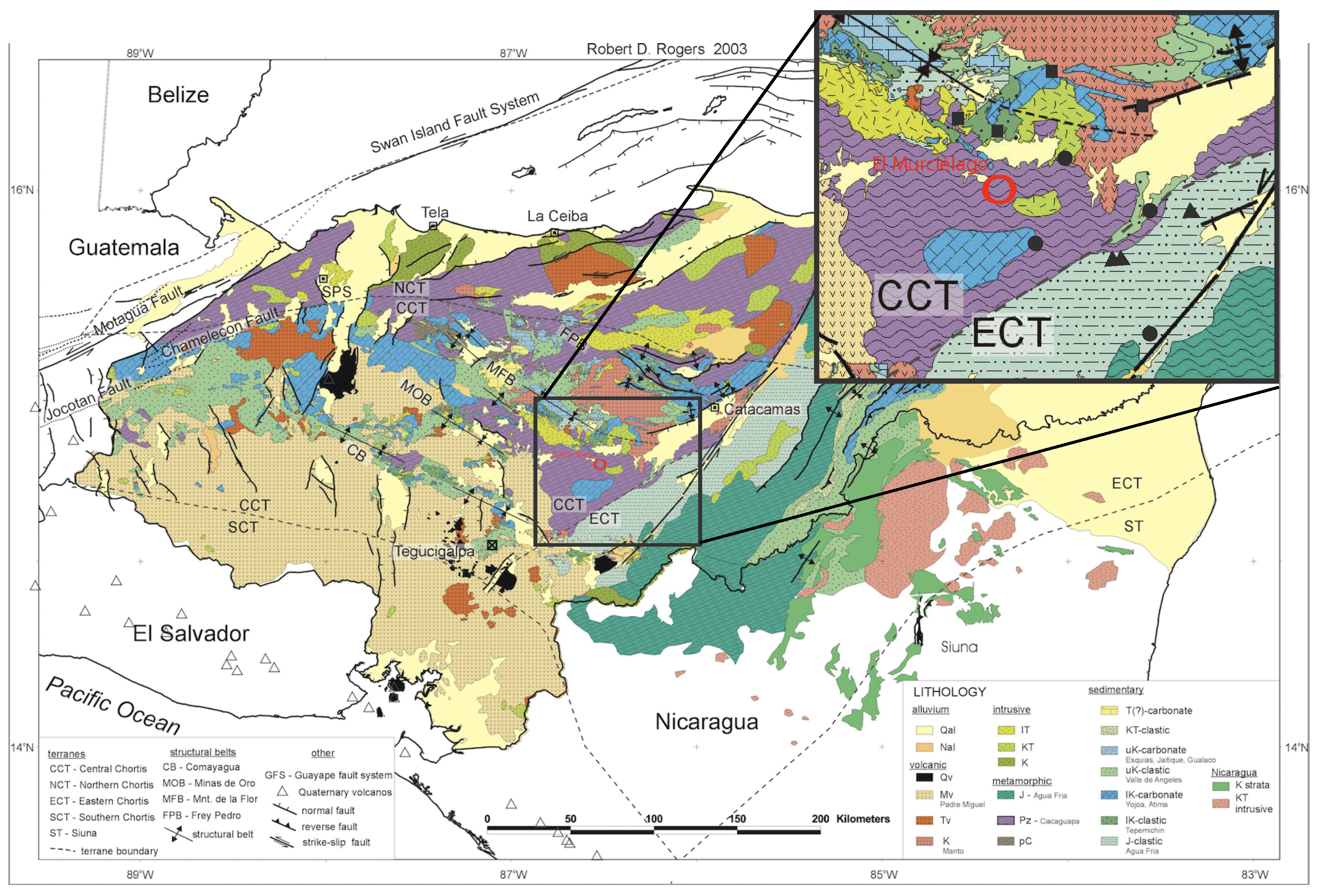
25], the Chortis Block is not homogeneous and can be divided into different tectonic terranes. Its basement consists of metamorphic rocks with poorly constrained ages, ranging from Precambrian to Cenozoic, overlain by Meso-Cenozoic sedimentary and volcanic units. The sedimentary sequence consists of Middle Jurassic and Lower Cretaceous clastic sedimentary sequences, Lower Cretaceous carbonatic rocks, and Middle to Upper Cretaceous red beds and limestones intruded by Cretaceous and Tertiary granitic bodies. Cenozoic deposits largely consist of volcaniclastic rocks. The investigated area is located in the Lepaguare Valley (Olancho Department), about 100 km NE of Tegucigalpa (
Figure 1). In this area, the basement is made up of low-grade metamorphic rocks represented by well-foliated graphitic and sericitic schists and quartzites that can be referred to as the Cacaguapa Group. This Paleozoic basement is overlain by a relatively thick sequence of sedimentary rocks of roughly Jurassic to Cretaceous age, which includes two main units. The lower one consists of massive, dark-gray to black, strongly fractured limestones of the Lower Cretaceous age. This unit belongs to the Atima Formation, Yojoa Group [
23], which crops out mainly in the mountains north of the Lepaguare Valley and to the south of the investigated area (
Figure 1). The upper unit is instead represented by Upper Cretaceous redbed siliciclastic strata, which contain quartz-rich conglomerates, limestones, and minor evaporite rocks. The dominant lithologies are quartz pebble conglomerates, with poorly sorted, subangular to rounded quartz and quartzite pebbles in a fine red matrix. These strata belong to the Valle de Angeles Formation [
25] that discontinuously crops out along the Guayape river. During the Upper Cretaceous–Lower Tertiary, these Mesozoic sedimentary units were intruded by a granodiorite pluton, which crops out a few tens of kilometers north and northwest of the Canan area. It corresponds to a medium-grained, equigranular, magnetite-bearing biotite-hornblende-granodiorite, varying locally to granite and quartz monzonite [
9]. This intrusion is responsible for most of the metallogenic mineralizations within the Cacaguapa Shists (
Figure 1). As described by [
11,
12,
13,
26], the Canan Lode gold deposit is associated with quartz-veined shear zones, and the mineralization occurs in the low-to medium-grade pre-Mesozoic metamorphic basement (graphitic and sericitic schists). Quartz veins were formed by hydrothermal fluids (associated with the emplacement of Cretaceous-Tertiary granodioritic intrusions) that altered the wall-rocks. Auriferous quartz vein formation is related to ductile shears and fault zones where hydrothermal fluids dominated by carbonate-chloride-bearing solutions and CO
-CH
-carbonic fluids circulated. The Murcielago gold placer is located along the Guayape river in the southern margin of the Lepaguare Valley (
Figure 1). It represents a typical meandering channel deposit with a fining upward sequence. Coarser sediments are constituted by schists and granitoid rocks in a sandy–silty matrix comprising a wide variety of minerals.
5. Discussion
The Murcielago gold deposit is a placer located along the Guayape river. The meandering channel deposit is the result of the erosion of the Guayape river in the hydrographic basin, which is characterized by a sequence of schists, redbeds siliciclastic, and granitoid rocks. Evidence of metallogenic mineralization is reported at the schists level. The placer mineralogy reflects the complex lithology of the area where the Guayape river is located (
Figure 9). The presence of key minerals, such as epidote, tourmaline, and garnet end-members (almandine, grossular, and andradite), as well as biotite and phlogopite, monazite, xenotime, and zircon, suggests a provenance from metamorphic and granodioritic lithologies of the area and the relative mineralized rocks (i.e., Cu–Au skarn) from the nearby ore district [
5,
9,
15]. In particular, accessory minerals of the granodioritic rocks (i.e., monazite, xenotime, and zircon) and the presence in the heavy fractions of metal oxide and sulfide, such as cassiterite, wolframite, and altered pyrite, suggest that the sediments of the Guayape river are mainly linked to the erosion of the mineralized units of the Cacaguapa Schists.
Although several mineralized units are reported in the area, the lode gold source of the Murcielago placer is still unknown. Cu–Au skarn and hydrothermal lode deposits are the only known gold mineralization in the area [
9,
12,
13], and thus, they could be the best candidate source for the Murcielago gold placer.
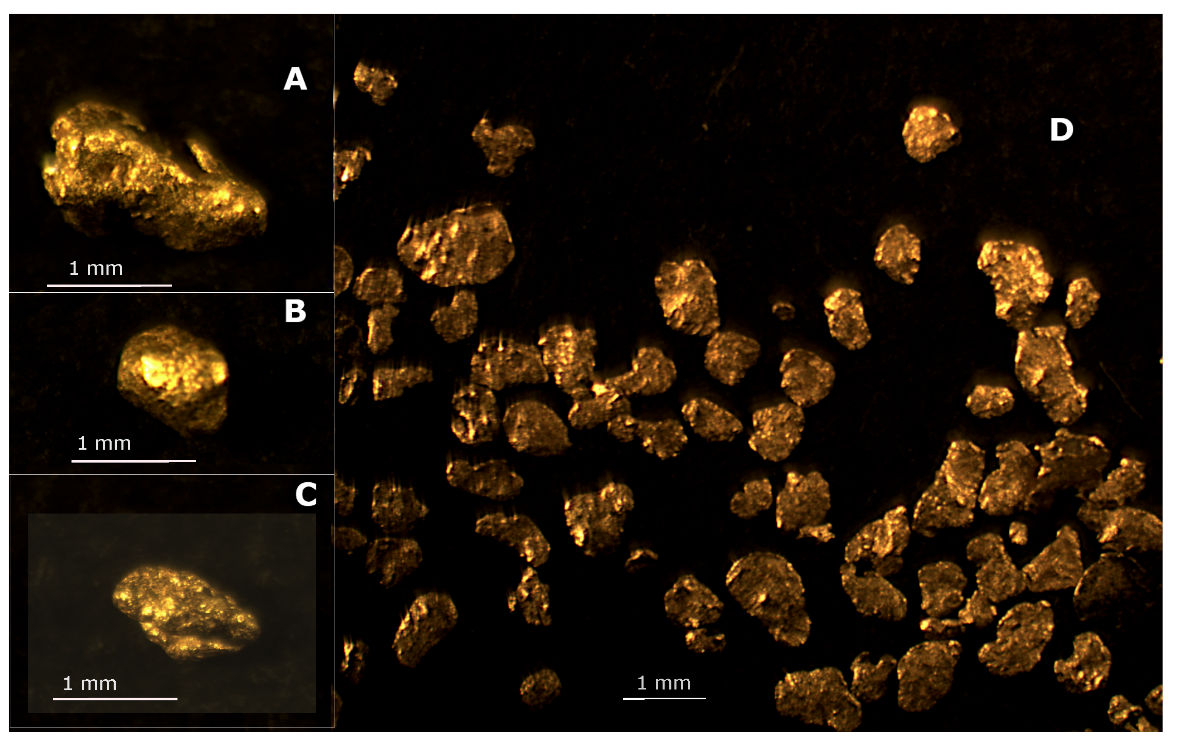
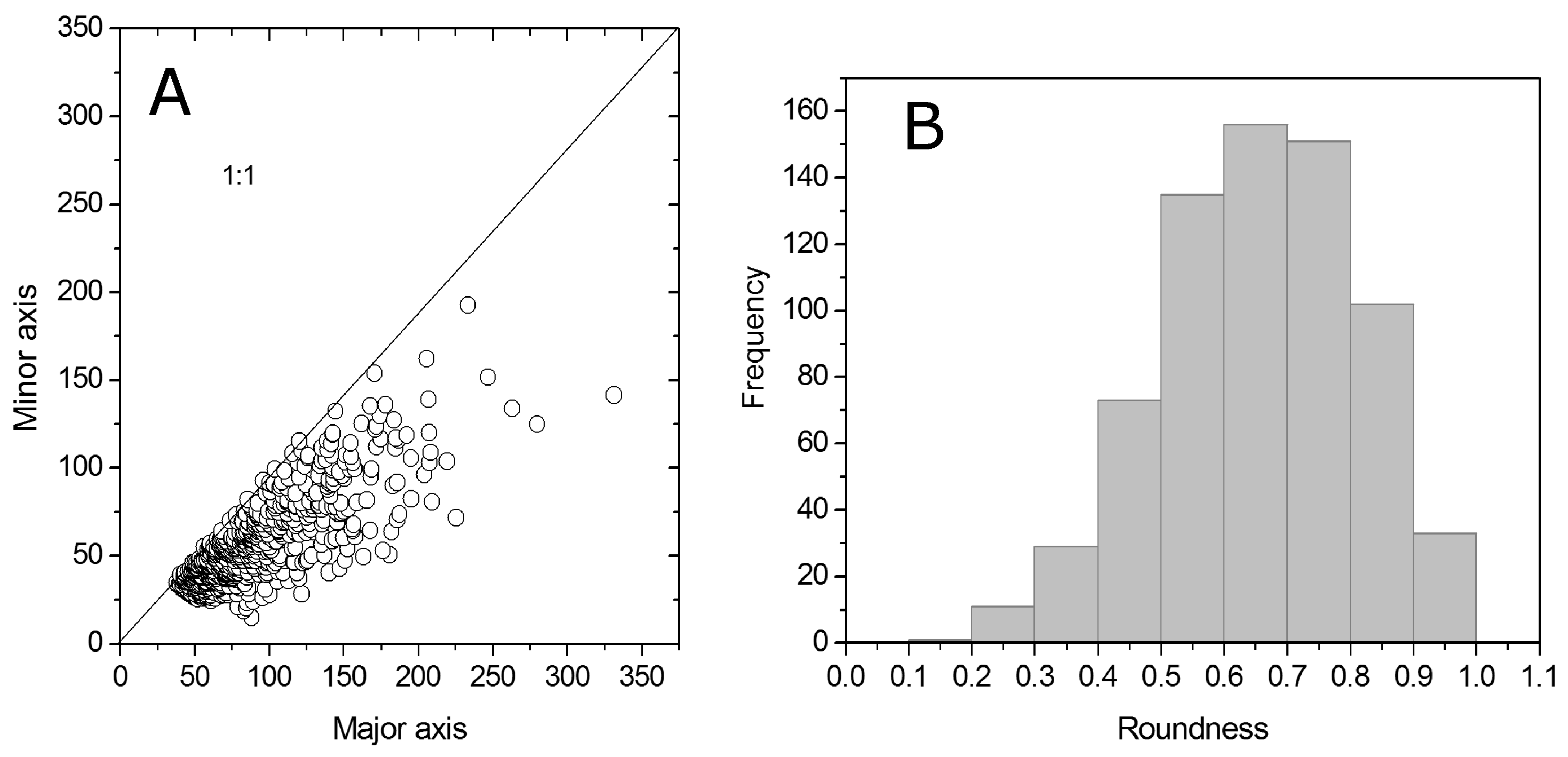
The gold grains recovered from the Murcielago placer production plant are mainly flattened grains, and from the morphometric analysis, they resulted in moderately to high elliptical shape (
Figure 2). As observed by Masson et al. [
20], gold grains sampled at different distances from the lode deposit in the Rivière du Moulin (Québec, Canada) have no significant change in flatness with the distance of transport (up to 10 km) or roundness along the river. By contrast, a slight decrease in ellipticity, from high to moderately elliptic particles, and an increase in roundness, from moderately to highly rounded, with distance are reported. Nevertheless, they suggested that the observed grain morphology can be affected not only by the distance of transport but also by multiple gold sources. Since our samples come from a single production site, and we observe a significant spread in the shape descriptors (including rough gold grains plus quartz), a possible hypothesis (in analogy with [
20]) is that some gold particles may have traveled longer than the others, implying a variable distance from one or multiple sources. Nevertheless, to confirm this hypothesis, further analysis considering the alloy composition of the sub-population will be necessary.
Recently, Chapman et al. [
31] reported a comprehensive study on alluvial gold from a huge placer gold database from locations worldwide in determining the contributions of detrital and authigenic gold to fluvial placers. Murcielago gold alloy varies continuously in the Au
Ag
–Au
Ag
range, as measured at the core of the grains. The compositional range can be considered primary and ascribed both to a variation in the precipitation conditions present in the source (temperature or pH variation of Au concentration, aH
S and aCl
(aq); increase in Ag in the alloy) and/or to multiple sources.
The lode deposits present in the area of Canan are the only hypogene deposits of which we had samples. No chemical analyses of gold composition are reported in the literature as far as we know. Thus, inferring a possible source is extremely difficult, but we can make some comparison with the nearby Canan deposit. Although the cumulative curves for Canan and Murcielago slightly differ (
Figure 6), the composition of Canan gold grains (Au
Ag
–Au
Ag
) overlaps that of the Murcielago placer. The limited amount of Canan samples analyzed prevents better describing the possible difference between the two populations. Moreover, as reported by Chapman et al. [
31], the gold alloy major composition alone cannot discriminate between different sources. Few grains from the Murcielago placer have an Au-rich rim of a few microns thick (
Figure 4). The presence of Au-rich rims in placer gold grains is usually secondary and related to the micron-scale overgrowth of pure Au or to Ag depletion processes that can occur during the history of the gold from the source to the placer deposit [
30,
32]. The thickness of the Au-rich rim depends on the pristine condition before the particle enters the fluvial system and/or the residence time in the system itself. Generally, the Ag-depleted inner rim has a thickness of around 20 µm and a geometry broadly mirroring the particle edge.
In our case, rim composition is around 1–2 at% Ag and, together with the morphology of the grains, may be compatible with Ag removal processes possibly during the residence in the placer. Some additional information can be obtained from the analysis of the inclusions present in the polished section and the finding of gold grains associated with quartz found in the concentrated material. The observed mineral inclusions did not present a void between the host gold and the ore mineral, thus suggesting a primary origin. The association is arsenopyrite, pyrite, acanthite, sphalerite, and hematite. In particular, pyrite and sphalerite are very common in several styles of mineralization (e.g., orogenic, skarn, and epithermal gold) and could not be discriminant on one or more sources [
30,
31,
33]. Moreover, the inclusions are found in gold grains of a similar composition (Au
Ag
and Au
Ag
) but with the few available data, we cannot unambiguously define them as a single or multiple gold types. Nevertheless, pyrite, arsenopyrite, sphalerite, goethite, and hematite are among the ore minerals present in the Canan gold deposits, and the Murcielago chemistry of gold grains with inclusions is also compatible with the Canan gold composition. We did not observe mineral inclusions in the Canan gold grains, probably because of the scarcity of available materials. Moreover, the observed gold grains with associated quartz are in the 1 mm to 0.4 mm range and look primary, therefore suggesting a proximal source where gold is associated with quartz.
6. Conclusions
Data from the literature on gold from ore deposits of Honduras are extremely scarce, and gold compositions are lacking, with the exception of those reported by [
13] for the Canan lode deposits. In this study, we report the first data on the chemical characterization of the Murcielago gold placer and a comparison with gold from the Canan lode deposit in the Olancho Department. The morphology range of the placer gold grains, their chemical composition, and the substantial lack of extensive Ag depletion suggest that the gold may have been transported from variable distances and possibly from multiple sources.
The presence of gold associated with quartz in the placer materials and the ore mineral inclusions observed in the gold grains give new constraints to the possible source(s) that should be searched for the gold deposits present in the hydrographic drainage of the Guayape river (
Figure 1,
Figure 2,
Figure 3,
Figure 4,
Figure 5,
Figure 6,
Figure 7,
Figure 8 and
Figure 9), although a poor knowledge of the gold deposits in the district makes it more difficult to infer which is/are the source(s) of the Murcielago gold placer. In this way, we tentatively compared the composition of gold from the Canan lode and the placer deposits, which resulted consistently.
Although the hydrographic drainage of the Canan gold deposits could not be directly related to the Murcielago placer, it is conceivable that, further west-southwest, some tributaries of the Guayape river, just a few kilometers upstream from the Murcielago alluvial sediments, cut, within the widespread Cacaguapa schists, some hydrothermal gold mineralization genetically similar to that of Canan. Moreover, the presence of andradite garnet, pyrite, and magnetite in the concentrated material of the Murcielago placer seems to suggest that Cu–Au skarn deposits of the Cagaguapa schists could be an additional candidate source for the investigated placer.


 ,
, 


