Abstract
Salt harvesting through natural solar evaporation of salt brines is a practice notably abundant in the Iberian Peninsula. Such activity has been relevant for human consumption, food preservation, livestock feed, and various industries throughout history. The objective of this research is to analyze the productive history and conservation state of the salt evaporation ponds located in Naval and Peralta de la Sal (Huesca, Spain), as well as their didactic potential. These saltworks are associated with clay and gypsum levels from the Upper Triassic (Keuper). The earliest written records of salt production in the area date back to the 10th century, but they were exploited as early as the Bronze Age. Remains of most of the ponds and some buildings are still preserved and are easily accessed, which makes them very interesting from an educational perspective. Both on-site and off-site activities can be carried out to analyze their historical and current significance through modeling and argumentation practices. This can lead to a better understanding of how geology relates to everyday life and facilitate the development of positive attitudes among students towards geoheritage while raising awareness about its preservation and preventing its degradation.
1. Introduction
The production and trade of salt has been a very relevant activity in the Mediterranean zone even since prehistoric times, first for human consumption and later for food preservation, livestock feed, and various industries.
Salt harvesting processes in continental saltworks can be carried out in different ways. The most direct method of obtaining salt is through the evaporation of natural salt brines, a technique that was already used in pre-industrial times. Still, depending on the characteristics of the process, it can be divided into two types: first, by exposing the brine to atmospheric agents (sun and wind), and second, if the climatic conditions are insufficient for natural evaporation, mechanical means and artificial techniques involving the application of heat can be used [1]. Besides using natural salt water, brines can also be obtained artificially, forcing the circulation of water in galleries that run through saline materials, collecting the salty water, and taking it to evaporation and crystallization ponds.
In the Mediterranean area, continental saltworks are usually too small for the introduction of mechanical means, even though this would lower costs and increase production [2]. Even so, numerous techniques have been employed, such as the use of forest timber to evaporate water using heat, which generated environmental problems in the past in Europe [3].
Saltworks in which salt is obtained through evaporation by the action of the sun and wind are very rare in Europe but considerably abundant in the Iberian Peninsula [4]. They have given rise to a cultural heritage that is reflected not only in the buildings and infrastructures but also in the population and the environment, with these being areas of great value.
In the case of Spain, there is a variation in the techniques used that is directly related to the climatic variability of the territory. On the one hand, saltworks located in the north are conditioned by a more accentuated rainfall, which makes it necessary to use methods that accelerate evaporation and crystallization. On the other hand, those located in the central, eastern, and southern parts are subject to less adverse weather conditions, with more heat in summer and fewer storms, and mainly use natural evaporation [5]. The latter was the predominant method used in Spanish saltworks in the mid-nineteenth century.
Saltworks are very relevant not only for the products they generate but also because they encompass a vast span of values, including cultural, social, and natural ones [6]. In the present day, saltworks face significant threats, such as exposure to the elements, and are swiftly diminishing, posing a risk not only to cultural and social heritage but also to the conservation of geological heritage, especially in less populated areas.
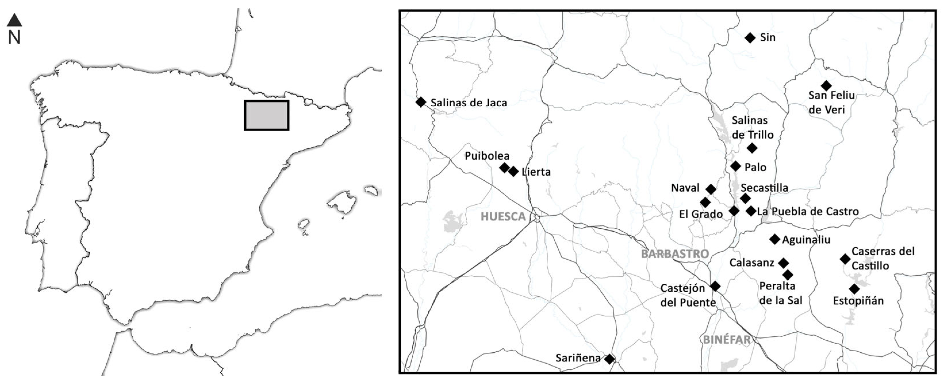
The purpose of this work is to highlight the geological, cultural, social, and educational heritage of the saltworks located in the Huesca province (Spain). More specifically, those situated near the villages of Naval and Peralta de la Sal (Figure 1). As such, the focus will be first to summarize the history of these salt-producing areas, describe the remains and cultural patrimony that is currently preserved, and analyze the potential of these saltworks as educational resources.
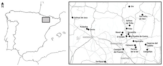
Figure 1.
Geographical position of the saltworks of the Huesca province (Spain). In some cases, villages, such as Peralta de la Sal, take their name from the presence of the saltworks.
2. Geoheritage: The History of Salt in the Huesca Province
Up until the mid-20th century, salt played a crucial role in the Spanish economy. The transportation of salt from the coastal regions to the inland areas of the Iberian Peninsula was challenging and costly, mainly due to the inadequate communication infrastructure. Consequently, the exploitation of salt springs and brines emerged as a lucrative source of wealth, resulting in the establishment of around 200 salt evaporation sites [1].
Salt evaporation ponds are large shallow basin reservoirs designed to extract salt from brines, salty lakes, or seawater through natural evaporation, among other processes [7]. Usually, these ponds are carefully designed to maximize the surface area that is exposed to the sun and wind, facilitating the evaporation of water and the crystallization of salt. In the case of Spain, there are many geological formations that can become a source of sodium chloride, such as Keuper materials (Triassic), and the climate, warm and dry in summer, can favor evaporation in these ponds.
The first written records of salt production in the Huesca province date back to the Christian conquest in the 11th century. The main references are primarily related to periodic provisions of salt, provided free of charge to religious institutions, or the granting of salt mine rights as compensation for services rendered or repayment of debts owed to nobles and merchants [8]. In general, the ownership of salt mines, especially the larger salt production ponds such as Naval, Peralta, Calasanz, and Aguinaliu, was not in the hands of single individuals. Instead, each set of evaporation and crystallization ponds had a distinct owner. Additionally, it was common for a portion of the salt ponds to be owned by religious institutions, either through donations from individuals or through royal grants. This arrangement provided a steady source of income, enabling the construction of significant churches and monasteries.
2.1. Saltworks in Naval
In Naval, there are multiple saltwater springs that might have been discovered and used since prehistoric times. Archaeological remains suggest that the Naval saltworks were exploited as early as the Bronze Age and experienced a significant boom during the Roman era [9]. However, present saltworks were established during the Muslim period, and the first written document referring to the salt activity in Naval dates to 1094 [10].
Studies have shown that the average salinity of the La Llastra ravine is around five grams per liter, with a sodium-chloride composition [11]. This is mainly due to the presence of numerous saline springs and to the geological composition of the terrain through which it flows, where gypsum from Keuper facies predominates. Additionally, saline springs can reach concentrations of up to 300 g per liter.
Two saltworks were mainly exploited in Naval. The first, known as the Iruelas saltwork, is located approximately one kilometer northeast of Naval. The second, La Rolda saltworks, is located to the south of the village. Even if there is evidence in different records and documents that there were other saltworks in the area, such as Ranero, Cuestamonzot, Rosico, Pisa, and La Cua [8], hardly any remains are preserved [12]. In the village of Naval, a salt storage building was originally constructed around the mid-13th century. This building has undergone several renovations, and it still stands today. Inside, it is possible to see remains from various historical periods, with the oldest visible remains likely dating back to the 16th or 17th century.
2.1.1. Iruelas Saltworks
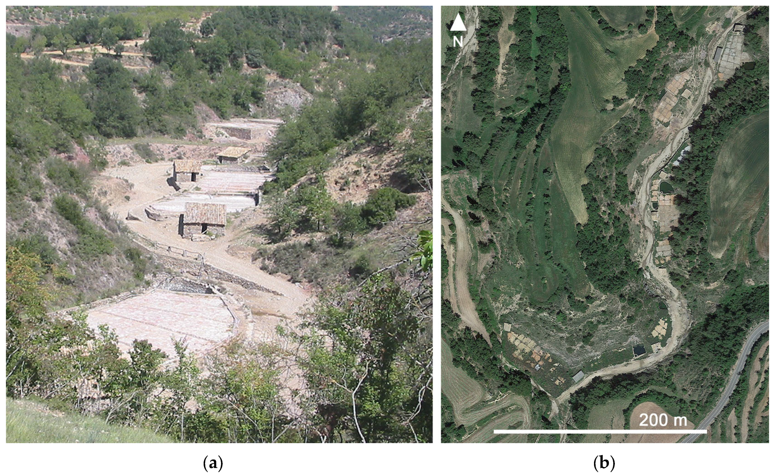
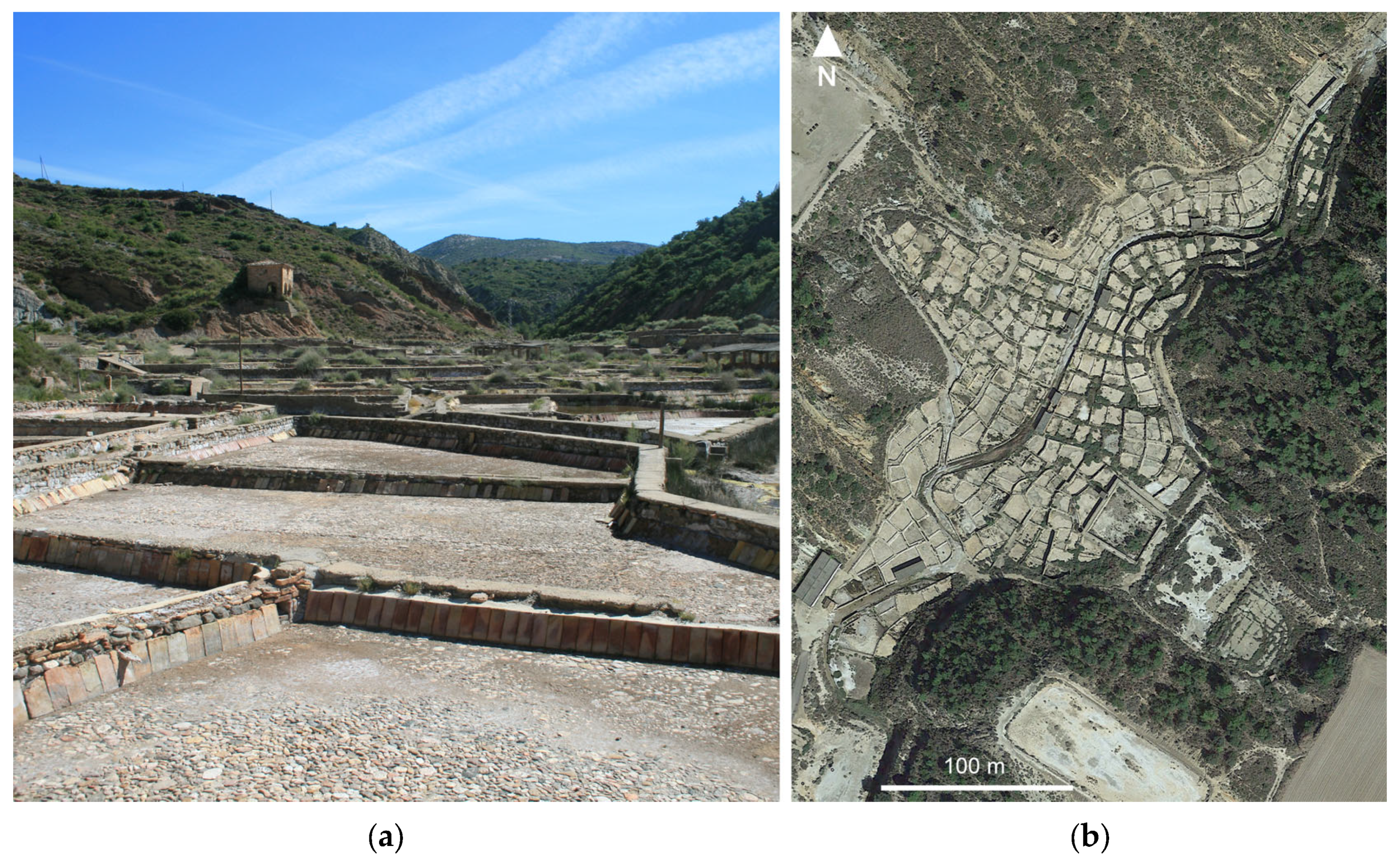
The Iruelas saltworks are in the Guibano ravine bed. They were discontinued some time ago due to their low economic productivity. However, most of the buildings and the ponds are still in reasonably good condition (Figure 2a,b). They can be accessed by a road that originates from Naval, leading from El Grado to Abizanda.
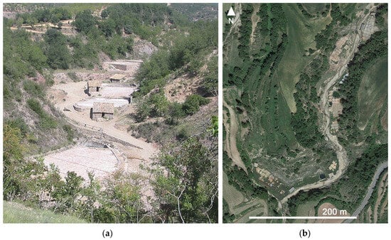
Figure 2.
(a) Some of the salt evaporation ponds that are preserved in the area (author: Josep María Mata); (b) Aerial view of Iruelas saltworks.
The site chosen for the construction of these saltworks, as mentioned by some geologists as early as the 19th century, was not the most suitable [13]. At that time, frequent flooding resulted from water flowing down the ravine during heavy storms, causing significant damage to the saltworks present in the area. Furthermore, during the 19th century, a public road, which used to lead to a village that no longer exists, traversed a considerable portion of the salt flats, leading to several incidents.
The salt brine was extracted from a well of about twelve meters deep and about two square meters in cross-section, which allowed for a yield of approximately 2350 cubic meters each year. This spring provided a highly concentrated brine, more so than those of La Rolda, enabling the filling of the ponds to a greater extent [10]. Since the property of the saltworks was divided among different neighbors, each with its own facilities, they were entitled to a certain amount of salt water per year.
During the 19th century, there were a total of 185 crystallization ponds [5]. These ponds were traditionally constructed with rammed earth for the bottom and walls, which were then covered by a thin layer of highly malleable clay, which probably gave the salt a brownish color [14]. The separation between each pond was achieved using wooden planks for the walls, while the floor was composed of thick ceramic tiles [5].
To obtain the salt, first, the salt brine was accumulated in the concentration ponds and transported, through wooden channels, to each of the crystallization ponds. From July to October, salt was recovered, and the evaporation process usually lasted between six and fourteen days.
When it rained, the less dense rainwater would stay on the surface while the salt water remained underneath. To remove rainwater, the walls of the ponds were equipped with holes in the upper part. These holes were typically covered, but they could be uncovered when necessary [10]. Additionally, to prevent the salt water from mixing with the surface water, each of the ponds had a small well attached to it so that salt water alone could be extracted through the bottom. When rainfall was expected, the salt was collected, although in more recent decades, in certain ponds, roofs were installed that not only protected them but also accelerated evaporation and lengthened the production period [15]. Although the remains of the ponds and some buildings are still preserved, these saltworks have suffered significant environmental degradation [16].
2.1.2. La Rolda Saltworks
These saltworks are located on the right bank of the Llastra ravine, four hundred meters south of the village. They can be accessed by road. Although historically, La Rolda saltworks had 19 concentration ponds and 167 crystallization ponds [5], today, much less are preserved. During the 19th century, as there was a public road that crossed the ponds in the northwestern area, walls were built around them to prevent entry.
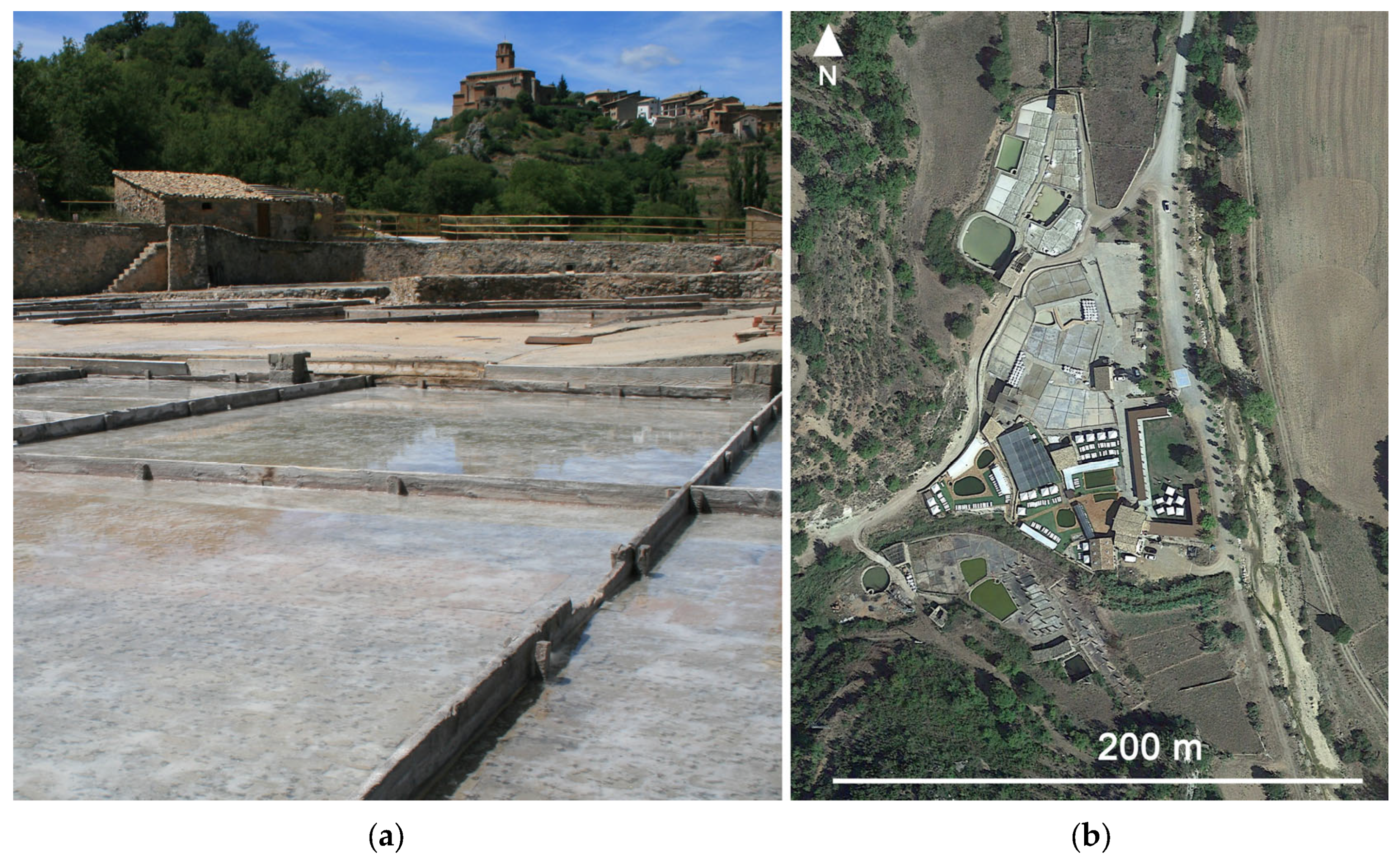
The salt brine was obtained from an artesian well and was accumulated in a deposit. Then, it was distributed to the concentration ponds, which had auxiliary wells to extract the more concentrated water from the bottom. From there, it went to the crystallization ponds (Figure 3a,b). In La Rolda saltworks, the floors of these ponds are made of thick ceramic tiles.
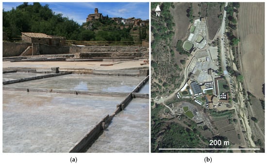
Figure 3.
(a) Some of the salt crystallization ponds that are still preserved in La Rolda saltworks; (b) Aerial view of La Rolda saltworks.
The salt concentration of the springs that supplied La Rolda saltworks was lower than those of other nearby saltworks, so a shallow layer of water was placed in the crystallization ponds [10]. As salt water evaporates, salt crystallizes first on the surface, forming light, partially hollow structures that float on top of the water. These structures are called fleur de sel due to the influence of the French language. Pliny the Elder, two thousand years ago, indicated that precisely this type of salt was especially appreciated in the kitchen, besides mentioning many different uses for natural and artificial salt, such as salt-based medical remedies [17]. As evaporation progresses, more salt crystallizes, which remains as crystalline aggregates at the bottom of the ponds.
In the 1970s, some of the crystallization ponds were covered with transparent roofs to be able to obtain salt throughout the year. Some of these saltworks were operated as a condominium formed by 61 members, the Sociedad Cooperativa de Salinas de Naval (Naval Salworks Cooperative Society). In 1995, the organization’s structure underwent modifications to increase its competitiveness. However, despite the efforts, it was not possible to overcome the low selling prices set by major industrial producers, which led to the cessation of the operations. In 2001, a project to reconvert the salt mine was initiated to resume its exploitation in an artisanal way, helping to preserve the geocultural and social heritage of the area. With an investment of more than one million euros, in 2005, some 300 tons of salt were already being extracted, with this being the only salt mine that is currently in operation in Huesca [10]. In 2009, a further step was taken with the intention of creating the first open-air spa in Europe.
At present, next to the operating crystallization ponds, in the area, there are several facilities intended for tourism and leisure. During the summer months, it is possible to enjoy therapeutic baths, for a fee, in one of the five salt pools of different sizes and depths that were restored in 2001. They are managed by the company Salinera Navalesa S. L. (Naval, Huesca, Spain), in which the town council and neighbors participate. There are also remains of the old ponds, currently not in use but well preserved, that can be visited [16], as well as interpretative panels that illustrate the history of the site and explain how the salt was exploited.
2.2. Saltworks in Peralta de la Sal
Peralta de la Sal is situated about 30 km southeast of Naval. The saltworks known as El Salinar are located about one kilometer away from this town, on the road leading to Gabasa. Even though the materials that outcrop the lands surrounding these saltworks are mainly Cenozoic gypsum, clay, and marls. The salt originates from Upper Triassic clay and gypsum levels (Keuper), which are found beneath these Cenozoic outcrops [16]. Specifically, salt water was extracted through a well from the Keuper materials. As a consequence of the geology of the area, the Sosa River, which passes near the town of Peralta de la Sal, has a high salinity [11].
As well as the Naval saltworks, these saltwater springs were probably already exploited as early as the Bronze Age, and evidence has been found that salt was already being produced with the briquetage technique, using fire to accelerate the evaporation [18].
The oldest document that is preserved about these saltworks dates from 987, in which a discussion about the possession of a salt well between two neighbors from nearby towns is narrated [19]. Between the 10th and 13th centuries, salt, being an essential commodity, became the subject of contention among various power groups competing for its possession. In the following centuries, salt production and export saw a significant rise, which led to nearby towns experiencing relative prosperity and the establishment of larger populations [19].
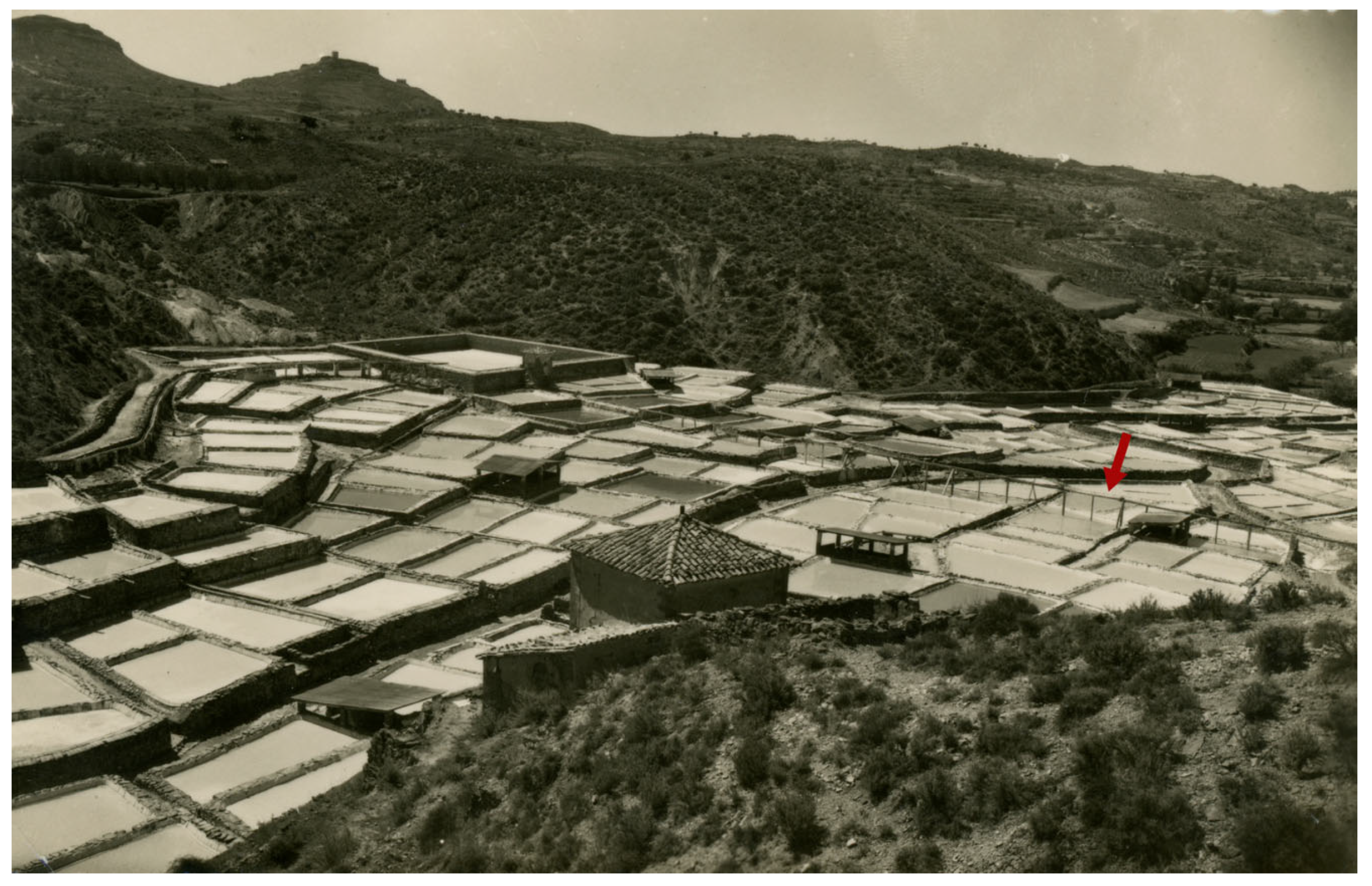
During the first half of the 19th century, when a large part of these saltworks belonged to the state, the saltwater was initially sourced from springs situated at the top of the ravine. After recollection, the water was transported to two storage and concentration deposits, one with a capacity of 250 cubic meters and the other with a capacity of 900 cubic meters [12]. A wooden channel made of hollowed oak logs was used to carry the salt water from the springs to the tanks and from the tanks to the crystallization ponds (Figure 4). Each wood fragment had between 3 and 5 m, which made it possible to create a very wide network [19].
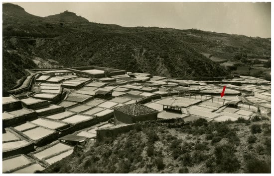
Figure 4.
Peralta de la Sal saltworks (circa. 1950). The photograph shows the wooden channel (indicated by the arrow) that carried the salt water from the concentration ponds to the largest tank, from where it was distributed into the crystallization ponds.
Water flowed into the crystallization ponds. These ponds are generally square or rectangular in shape, except for those at the ends, specifically designed to fit the terrain (Figure 5a,b). Between each pond, there were several narrow paths that served as separation as well as wider paths used for loading the salt [20]. Salt water was added until it covered about 15 cm in each pond. By sun exposure, fleur de sel soon appeared and, due to its density, it settled at the bottom. To prevent all the salt from adhering to the bottom, these crystallization ponds were stirred every two days, either at dusk or dawn [19]. Salt was mainly recollected between the months of July and September, and up to 40 laborers, including women, could be hired [1,20].
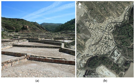
Figure 5.
(a) Current state of some of the crystallization ponds in Peralta de la Sal; (b) Aerial view of Peralta de la Sal saltworks.
At the beginning of 1980, these saltworks were still operating. New sources of salt water were sought, and new techniques were used, which increased production. The number of crystallization ponds was reduced, and instead of using the springs, salt water was pumped from a well that was 107 m deep and 18 cm in section [12]. This well had the capacity to yield approximately 3000 cubic meters of brine annually. There were around five persons recovering the salt, although in years of greater demand, there could be up to twelve people [18]. During that period, an average of 1440 kg of salt per season could be obtained, which, although a small amount was exported, mainly served the local needs of the food sector and the chemical industry. As size increased, production gradually increased and was around 3500 tons in 1995.
The site currently consists of 365 crystallization ponds distributed along the Sosa River and two of its tributaries. These ponds, which have been preserved in their original state since the mid-19th century, feature a floor composed of closely fitted pebbles (Figure 5a). The walls of these ponds are constructed with masonry and covered with thick ceramic tiles. These tiles are slightly angled, around 60 degrees, to aid in salt extraction and are filled with clay between the joints to prevent any leaks. The condition of the crystallization ponds is still good, although the rafts are in poorer condition. Moreover, remains of some buildings, like the guardhouse and the warehouse where salt was stored, and other constructions that were used, are also preserved.
Although salt production increased significantly, it was impossible to compete in price with the salt of the large industrial producers, so these saltworks ceased operations in 2000. In June 2007, Peralta de la Sal saltworks were declared BIC (Bien de Interés Cultural (an asset of cultural interest in English)), a legal figure of protection of the Spanish historical heritage.
3. Geoheritage: Outdoor Learning and Science Education
Outdoor activities are fundamental tools for teaching Earth Sciences, as they allow students to experience emotions and content in a practical way and in a more relaxed atmosphere [21,22]. This encourages the knowledge of the planet within a complete, holistic, and inclusive vision of our environment. It also promotes curiosity, creativity, and personal growth; the establishment of a connection with the environment that, in many cases, will translate into respect, care, and enjoyment of nature by society; and, if education activities or visits are designed based on appropriate methodologies and adapted to the students, geoheritage can also serve to promote scientific skills.
At the end of the 19th century, the pedagogical trend that advocated, among other aspects, the importance of going outside the classroom as part of the teaching–learning process for pupils gained momentum. In our time, outdoor learning is becoming more important because today’s children play outdoors less than previous generations [23] and spend more time in front of the television or other screens than at school [24]. There are five main purposes for applying field trips as a teaching tool: (1) to provide experience, (2) to stimulate students’ interest and motivation towards science, (3) to attribute relevance to science learning, (4) to develop observation and perception skills, and (5) to promote personal and social development [25]. Along these lines, some governments have introduced the need to incorporate field trips into the national curriculum [26].
The advantages of these field trips in terms of environmental literacy [27] and their proper emotional and physical development [28] are widely described in the literature. Early ages are fundamental to motivating scientific thinking, taking advantage of children’s innate curiosity and interest in the world around them [29,30]. They can be used not only for gaining knowledge [31,32] but also to stimulate students’ motivation and interest and facilitate meaningful learning [33,34]. Moreover, spending time outdoors is related to an increased respect for nature [35], pro-environmental behaviors of adults [36,37], reduction of negative emotions [38], and health improvements [39].
Many authors underline the educational value of studying the geologic history of the territory [22,40,41]. Promoting didactic experiences based on geoparks and geonatural trails and even creating geo-gymkhanas can facilitate the development of a positive attitude among students towards geoheritage and bring geological heritage closer to students [42]. In this context, the importance of geoenvironmental education for the promotion and preservation of geological heritage and geoethical values is very significant [43]. This can be achieved using geological heritage protected by different legal frameworks. As such, territories of excellence, such as UNESCO Global Geoparks (UGGps), national, regional, and institutional figures can be used to develop educational activities and help to show the geo-richness of the planet [44,45].
Different authors have emphasized their significance from a geotouristic point of view, using UGGps but also other geosites as local touristic products that offer a framework of a holistic geotouristic approach by setting a link between culture and nature [46,47]. They can also be linked with Sustainable Development Goals [48], and on their official websites, many UGGps present materials that can be used both on-site and off-site [49].
In some cases, the reluctance or problems that may arise when using these resources or going on outings outside the classroom may be due to unfamiliarity with the environment or the lack of relevant geoparks or geosites nearby. Nevertheless, from an educational perspective, the key is to take advantage of existing resources in the environment and not only focus on areas of recognized geological prestige. In such a respect, in any area, it is possible to locate interesting geological points and assess which elements may be susceptible to be used as georesources [50].
Other alternatives that can allow using geoheritage as a didactic resource are combining the visits with information and communication technologies (ICT) or even only using ICT. From virtual museums [51] to virtual samples or virtual visits to specific geosites [52], any digital resource can become a significant teaching tool. Such is the case of the virtualization of samples, such as fossils or minerals, which can contribute to improving the design and development of didactic sequences for out-of-school education [53,54]. Other options are using virtual synchronous visits [55] or even immersive virtual reality [56]. These proposals yield very positive results, indicating that, even in the case of not having a relevant geological site nearby, there are other options to transfer these contents to the classroom.
Such activities can allow for the development of transdisciplinary didactic activities for different educational levels and the general public, organizing teaching tools, and developing awareness, values, and responsibility towards geoheritage [54]. Moreover, the integration of georesources in the educational practice adds value not only to the local geodiversity but also, in certain cases, to cultural and social heritage as well [57]. As such, it can favor both the preservation of geological elements themselves and any other heritage that can be linked to it, both tangible and intangible. In this context, it is possible to link certain geosites with previous human activities, such as places where remains from antique mining activities are still preserved [58].
4. Saltworks as an Educational Resource
Different authors have analyzed saltscapes and saltworks, carrying out qualitative and quantitative assessments on the geotouristic, geoheritage, or educational value [44,59] as they are cultural landscapes that can be linked to the development of communities [7].
Saltworks can be approached from an educational perspective, considering their natural geological context and the physical and chemical processes that take place in them, but also from a cultural and social perspective. As with any other geosite, they can be used to encourage the development of scientific skills in visitors and students, promoting modeling and argumentation practices [60]. Moreover, they can serve the purpose of raising awareness about preserving this kind of heritage and preventing its degradation.
As summarized in [61], there are different relevant criteria that can be used to identify sites for educational use: (1) didactic potential, (2) geodiversity, (3) accessibility, and (4) safety. For instance, when talking about the didactic potential of a site, it is important that the geological features that are present can be easily understood by students of different levels [62]. In addition, in the case of geoheritage, and related to didactic potential, other issues such as fragility or vulnerability, preservation of the ponds and/or the buildings, heritage importance, and historical relevance of environmental degradation must be considered [16].
Regarding these last factors, saltworks in Peralta de la Sal are very well positioned, as they have a very high heritage, cultural, and historical relevance. The salt ponds, as aforementioned, are in a good state of preservation, allowing them to recreate the operating system of the saltworks and facilitating the comprehension of the salt extraction process. Conversely, the Naval saltworks, especially those of Iruelas, are in a poorer state, although they are nonetheless interesting given the smaller size of the pond. As for La Rolda, a key factor is that they are still being operated using traditional techniques. As for accessibility and safety, all saltworks are also easily accessed; they are located close to villages, being within walking distance. It is possible to reach them using roads and trails; the landscape surrounding them is not very steep and is considerably safe for students of different ages.
As with other elements of interest (geodiversity), not only the saltworks are relevant, but also the surrounding areas. In Naval, besides clay and gypsum levels from the Upper Triassic Period, it is possible to see quaternary materials (terraces) near the La Llastra ravine and sandstones and conglomerates belonging to the Graus Formation (Miocene).
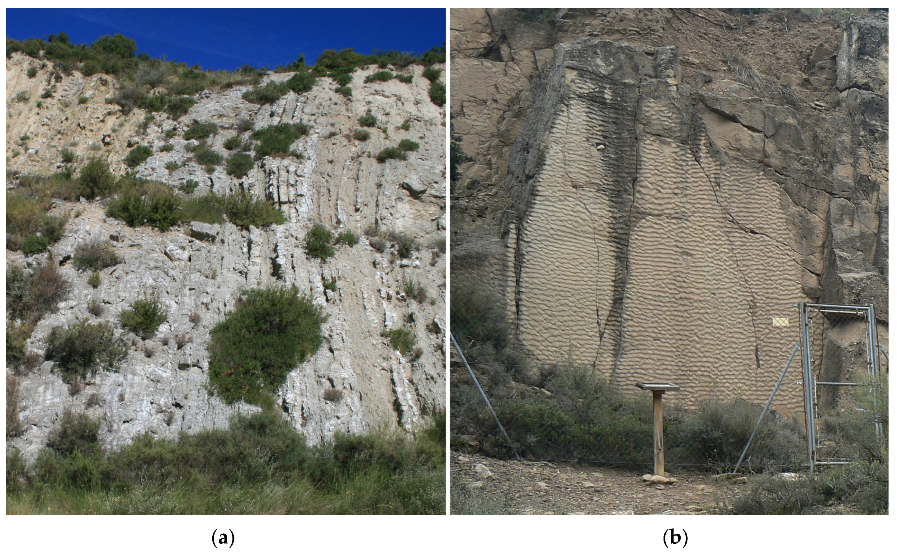
In Peralta de la Sal, it can be interesting to analyze the relief of the area and the disposition of the different materials. During the Alpine Orogeny, these materials were strongly folded, becoming part of the flanks of an anticline. As such, they are arranged almost vertically. This phenomenon is very frequent in the area, as in the surroundings of Peralta de la Sal, it is possible to see vertical gypsum strata (Figure 6a).
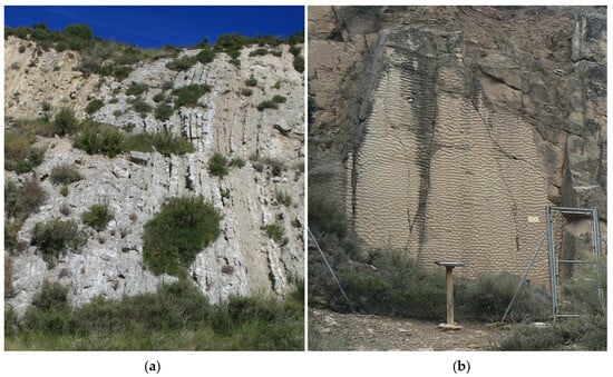
Figure 6.
(a) Gypsum strata, with vertical bedding, of the Upper Triassic (Keuper), located near Peralta de la Sal village; (b) General view of the paleo-beach (author: Diego Castanera).
Just one kilometer northwest of the city of Peralta, in an outcrop that can be easily reached, there are remains of an early Oligocene paleo-beach (Figure 6b). Along ripple marks, ichnites from six different types of animals have been recently identified: two birds and four small- and medium-sized mammals [63,64,65].
In the case of the didactic potential, as aforementioned, one of the key aspects is that the site can be widely understood by students of different educational levels and that the aspects that are relevant to the site are included in the official educational curriculum [62]. For instance, minerals and crystals are an object of scientific interest at different educational levels, and, to that end, salinas and saltworks can be used to understand how salt crystals form, specifically salt (halite) crystals, and under what conditions. Experimentation, inquiry, observation, identification, and establishment of conclusions by the students should be encouraged by observation of real crystals’ natural formation, both in situ and through the implementation of crystallization experiences in the classroom. Models and modeling competence are considered an essential part of scientific literacy and science education [66]. Crystallization experiments help to unmask the specific properties of crystalline matter (order, symmetry) through observation and allow the student to build their crystal with a scientific perspective. As such, aspects related to the physical properties of halite (at the macro level: color, streak, luster, among others; and at the micro level: chemical composition, internal structure), its origin, and its uses, along with the impact its extraction can have from different perspectives (social, environmental, etc.) can be considered [67]. However, an analysis of the compulsory education curriculum shows in Spain that these aspects are not always taken into account, nor is there a sequence of progressive deepening in this model [68,69]. Thus, it remains necessary to encourage students to establish relationships between these key points to build a complete and holistic mineral model.
Moreover, education and knowledge transfer are key points to consider when introducing geoheritage. It encompasses planning, traveling, arriving, visiting, leaving, remembering, and sharing experiences. A first approach to work on all these aspects is to make a field trip to the natural environment, tracing an itinerary that allows students to focus on different aspects. It is important that they analyze the origin of the salt water and understand the different salt obtention processes, the environmental factors that are involved, and its relevance from a cultural and social perspective, as well as the historical relevance of the site chosen and the importance of its preservation for future generations. All this can be carried out through different guiding questions, adapted to different educational levels, that can help students analyze and discuss what processes are taking place. For example, how does the crystallization process work in this case? What characteristics do the crystallization ponds have, or what are the uses of any visible remains (wells, wooden channels, builds, tools to recover or store the salt, etc.)? At the same time, students can also focus on other elements (other nearby geosites of interest, flora and fauna associated with saline soils, and cultural heritage). These topics can be approached using several procedures related to scientific activity and the natural environment: observation, comparison, classification, data collection, hypothesis formulation, argumentation, identification, collections, or problem solving, among others [70].
Additionally, saltworks can be easily recreated on a smaller scale through different experiments and situations. Starting from this contextualized situation, it is possible to conduct activities where students have a more active role and help them build new models that allow them to describe, explain, predict, or propose hypotheses and interpret experimental results [71]. Specifically, focusing on halite, cubic, transparent, or translucent crystals can be easily created from artificially created salt brines through experiences in which different hypotheses and variables are tested, allowing a more active and constructivist learning to be achieved. The variation of the different conditions allows for obtaining different results and favors justification. Practical experiences help manage variables, highlighting the need to simplify complex issues to analyze their impact on outcomes.
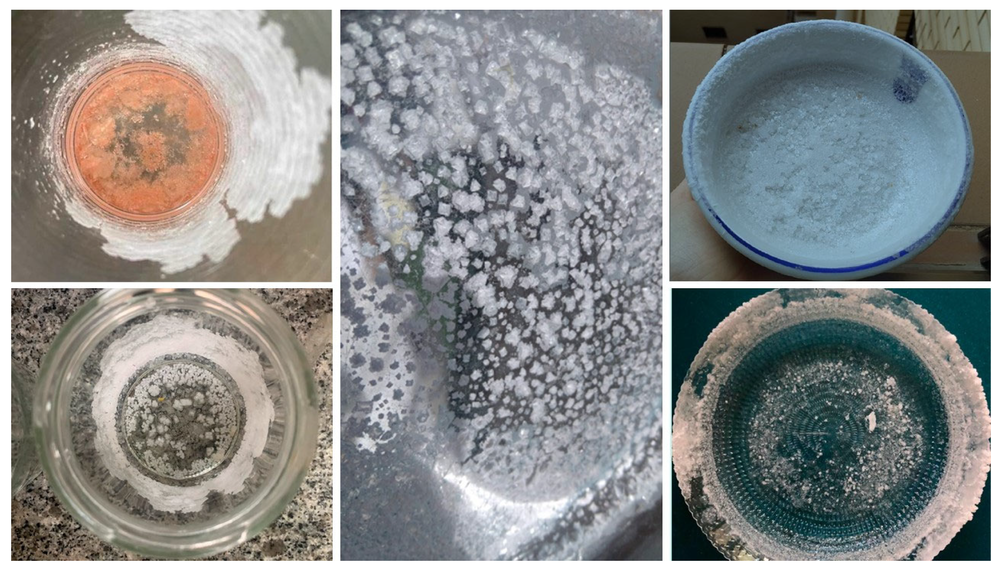
Examples of variables that are involved in the formation of crystals are available space, nature of the substance that crystallizes, the growth rate of the faces, degree of supersaturation, presence of impurities and/or dopants, nutrient supply, temperature and cooling rate, state of agitation, among other environment conditions [72]. In the case of salt crystallization experiments, different variables can be changed to allow obtaining different results (Figure 7). If salt crystals are formed, it can also be relevant to compare them to the different types of salt found in supermarkets, such as table salt or flake salt, using a microscope or hand-lens.
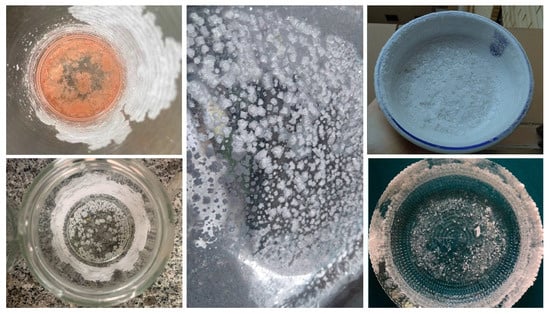
Figure 7.
Results of salt crystallization experiments carried out by preservice teachers changing different variables (proportion of salt and water, type of salt, size, depth of recipient, etc.).
Combined with the recreation of saltworks in the classroom and the crystallization of salt, there are also other initiatives that can be of interest, such as crystallization competitions [73]. In upper educational levels, other substances besides salt can be crystallized, and experimental projects can be created working with complex variables that influence the crystallization process. In addition, these initiatives are of great benefit to teachers, as they help them to improve their teaching practice or to get to know their students better. From the students’ point of view, it helps them to improve their motivation with respect to science classes and learn to plan and work autonomously [74]. Furthermore, studies have shown that educators highly appreciate the competition as a valuable instrument [75]. This hands-on experience serves as a basis for constructing scientific knowledge, making it an essential aspect of the learning process.
Besides minerals, exploitation of minerals, and their uses, there are other geological aspects and topics that can be addressed alongside these activities depending on the educational level for which they are intended: life on Earth (study of past and present fauna and flora), major geological events (Alpine Orogeny), reconstruction of the geological history of an area (analyzing the different outcrops), main forms of relief modeling and geomorphology (related to the hydrological network), geological heritage conservation, among others. All these contents are studied, to a greater or lesser degree of depth, in primary and secondary education and at university levels in certain degrees.
Considering all the aforementioned items, the global didactic potential of the saltworks described in this paper is quite relevant, considering not only the possibilities during an outdoor learning experience, which can include visits to other nearby sites of geological and historical interest, but also in the classroom. Additionally, these field trips and activities can be extrapolated to any other place where there are past and on-going exploitations of saltworks.
5. Conclusions
In Naval and Peralta de la Sal, salt was obtained from continental saltwater springs through natural evaporation by the action of the sun and wind, a technique that involves the use of very specific techniques and structures. Both saltworks still preserve important remains of the facilities and ponds that were used, some of them in good condition. And, in the case of Naval, besides crystallization ponds that are still currently operating, there are several facilities intended for tourism and leisure.
These saltworks have a considerable didactic potential as educational resources. In both cases, the sites are easily accessible, are in a reasonable state of preservation, and can allow a good understanding of the artisanal process of obtaining salt. Moreover, there are additional resources in the environment that can be used for educational uses, such as the geology of the area, the evolution of the landscape and life on Earth, the historical and current use of the land, or the social and economic relevance of salt production, among others.
Different studies suggest that primary and secondary school students tend to associate less positive emotions with geological topics [76,77]. These topics make them experience boredom or very little interest, and they find it difficult to understand their applicability in everyday life [78]. This may be due to the traditional teaching methodologies employed in classrooms. In this context, field trips to natural environments and geosites can help motivate students and reduce negative emotions associated with geology. In the context of visits to saltworks, this entails elements of geology as well as social and cultural factors. This combination allows for a clearer understanding of the relationship and practical relevance between daily life and geology. To that end, visits to saltworks and the realization of subsequent work and activities in the classroom related to obtaining salt by crystallization, such as inquiry-focused experiments or competitions, can help to contextualize them. It can also help to enhance the geological, cultural, and social heritage of a region and the importance of preserving it for future generations.
This work can be used as a preliminary study to lay the foundations of a contextualized didactic sequence that includes both on-site (visits to geological heritage landmarks related to the salt works) and off-site activities (crystallization experiments following an inquiry-based or gamification approach) that can allow students at different educational levels to work on the geological, historical, cultural, and environmental legacy of salt works and their surroundings. All these didactic proposals would also help the preservation of the saltworks, which are not currently being well maintained, increase their touristic value and their value as geological heritage sites.
Author Contributions
Conceptualization, G.C.; methodology, G.C., B.C.-Á. and J.M.-A.; investigation, G.C., B.C.-Á. and J.M.-A.; resources, B.C.-Á. and J.M.-A.; writing—original draft preparation, G.C., B.C.-Á. and J.M.-A.; writing—review and editing, G.C., B.C.-Á. and J.M.-A.; supervision, G.C. All authors have read and agreed to the published version of the manuscript.
Funding
This research received no external funding.
Data Availability Statement
Data sharing is not applicable.
Acknowledgments
The authors would like to acknowledge the group Beagle, Investigación en Didáctica de las Ciencias Naturales (S27_23R), the University Institute for Research in Environmental Sciences of Aragon (IUCA), and the Mixed University Research Institute CIRCE.
Conflicts of Interest
The authors declare no conflict of interest.
References
- Calvet, F.; Suñé, M. Les Salines Continentals Del Sud-Est Dels Pirineus. In Proceedings of the Actes de la VI Trobada D’història de la Ciència i de la Tècnica, Barcelona, Spain, 27–29 October 2002; pp. 251–267. (In Catalan). [Google Scholar]
- Moinier, B. The Appropriate Size of Saltworks to Meet Environmental and Production Requirements. In Proceedings of the Post Conference Symposium; Global NEST, Samos, Greece, 11–30 September 1999; pp. 49–65. [Google Scholar]
- Círillo, M.; Capasso, G.; Leo, V.A.D.; Santo, N.G.D. A History of Salt. Am. J. Nephrol. 2008, 14, 426–431. [Google Scholar] [CrossRef]
- Hueso-Kortekaas, K. Inland Landscapes: Values for a Sound Socioeconomic Development. In Las Salinas y la Sal de Interior en la Historia: Economía, Medioambiente y Sociedad; Universidad Rey Juan Carlos: Madrid, Spain, 2007; Volume 2, pp. 1043–1060. [Google Scholar]
- Plata Moreno, A. El Ciclo Productivo de La Sal y Las Salinas Reales a Mediados Del Siglo XIX; Diputación Foral de Álava: Gasteiz, Spain, 2006; ISBN 9788478216383. (In Spanish) [Google Scholar]
- Petanidou, T.; Dalaka, A. Mediterranean’s Changing Saltscapes: A Study of the Abandoment of Salt-Making Business in Greece. Glob. NEST J. 2009, 11, 415–433. Available online: https://journal.gnest.org/publication/519 (accessed on 15 September 2023).
- Hueso-Kortekaas, K.; Iranzo-García, E. Salinas and “Saltscape” as a Geological Heritage with a Strong Potential for Tourism and Geoeducation. Geosciences 2022, 12, 141. [Google Scholar] [CrossRef]
- Calvo Rebollar, M.; Calvo Sevillano, G. Sal y Salinas En La Provincia de Huesca; Prames: Zaragoza, Spain, 2020; ISBN 9788483215067. (In Spanish) [Google Scholar]
- Rodríguez Gómez, J.M. Arrieros en Serrablo: La sal y el origen de la arriería (II): Naval, centro salinero del Alto Aragón (I). Serrablo 2008, 148, 2. (In Spanish) [Google Scholar]
- Rodríguez Gómez, J.M. La Sal y Las Salinas de Naval: El Oro Blanco Del Somontano; Iter, Investigación y Territorio; Instituto de Estudios Altoaragoneses: Huesca, Spain, 2015. (In Spanish) [Google Scholar]
- Bescós Roy, J.M. La salinidad de las aguas superficiales en el Pirineo oscense. Lucas Mallada 1991, 3, 9–26. Available online: https://revistas.iea.es/index.php/LUMALL/article/view/935 (accessed on 15 September 2023). (In Spanish).
- Calvo Rebollar, M. Sal y Salinas de Aragón. In Proceedings of the Explotación Histórica de la Sal: El Patrimonio de la Sal, Peralta de la Sal, Huesca, Spain, 7–9 November 2019; pp. 73–94. (In Spanish). [Google Scholar]
- Mallada, L. Descripción Física y Geológica de La Provincia de Huesca: Memorias de La Comisión Del Mapa Geológico de España; Imprenta y Fundición de Manuel Tello: Madrid, Spain, 1878. (In Spanish) [Google Scholar]
- Gómez Miedes, B. Comentarios Sobre La Sal; Ramos Maldonado, S.I., Ed.; Palmyrenus: Colección de Textos y Estudios Humanísticos; Instituto de Estudios Humanísticos: Alcañiz, Spain; Laberinto: Alcorcon, Spain; CSIC: Madrid, Spain, 2003; ISBN 9788484831876. (In Spanish) [Google Scholar]
- Fuster Santaliestra, V. Las Salinas de Naval: Una Historia Milenaria. Rolde 1987, 41–43, 114–119. (In Spanish) [Google Scholar]
- Mata Perelló, J.M. Datos para el Conocimiento de las Salinas Continentales Pirenaicas de Aragón: La Explotación Histórica de la Sal: Investigación y Puesta en Valor. 63–72. 2009. Available online: https://upcommons.upc.edu/handle/2117/6567 (accessed on 15 September 2023). (In Spanish).
- Asandulesei, M. Salt Exploitation References in Plinius Maior’s Work. Stud. Antiq. Archaeol. 2022, 28, 454–472. Available online: http://saa.uaic.ro/wp-content/uploads/SAA.28.2.2022.12.pdf (accessed on 15 September 2023).
- Agudo Blanco, S. Historia Del Patrimonio de La Sal En El Parque Gológico y Minero de La Litera y La Ribagorza. In Proceedings of the Explotación Histórica de la sal: El Patrimonio de la Sal, Peralta de la Sal, Huesca, Spain, 7–9 November 2019; pp. 145–168. (In Spanish). [Google Scholar]
- Fuster Castera, P.; Tomás Zarroca, P. El Salinar de Peralta de La Sal. Temas Antropol. Aragonesa 2009, 16–17, 231–246. [Google Scholar]
- Bayona Vila, V. La Documentación Sobre Las Salinas de Peralta de La Sal. In Proceedings of the Explotación Histórica de la Sal: El Patrimonio de la Sal, Peralta de la Sal, Huesca, Spain, 7–9 November 2019; pp. 135–144. (In Spanish). [Google Scholar]
- Elkins, J.T.; Elkins, N.M.L. Teaching Geology in the Field: Significant Geoscience Concept Gains in Entirely Field-Based Introductory Geology Courses. J. Geosci. Educ. 2007, 55, 126–132. [Google Scholar] [CrossRef]
- Moutinho, A.; Almeida, A. The Importance of Geology as a Contribution to the Awareness of the Cultural Heritage as an Educational Resource. In Geoscience Education: Indoor and Outdoor; Springer: Cham, Switzerland, 2016; pp. 85–101. ISBN 9783319433189. [Google Scholar]
- Clements, R. An Investigation of the Status of Outdoor Play. Contemp. Issues Early Child. 2004, 5, 68–80. [Google Scholar] [CrossRef]
- Desmurget, M. La Fabrique Du Crétin Digital; Seuil: Paris, France, 2019; ISBN 9782021423310. [Google Scholar]
- Sorrentino, A.V.; Bell, P.E. A Comparison of Attributed Values with Empirically Determined Values of Secondary School Science Field Trips. Sci. Educ. 1970, 54, 233–236. [Google Scholar] [CrossRef]
- Halinen, I. The New Educational Curriculum in Finland. In Improving the Quality of Childhood in Europe; Alliance for Childhood European Network Foundation: Brussels, Belgium, 2018; Volume 7, pp. 75–89. ISBN 9789082290929. [Google Scholar]
- Győrössy, K.; Földes-Leskó, G. Nature Wandering as a Means of Environmental Education. J. Appl. Tech. Educ. Sci. 2021, 11, 36–58. [Google Scholar] [CrossRef]
- Dankiw, K.A.; Tsiros, M.D.; Baldock, K.L.; Kumar, S. The Impacts of Unstructured Nature Play on Health in Early Childhood Development: A Systematic Review. PLoS ONE 2020, 15, e0229006. [Google Scholar] [CrossRef]
- Amaro, F.; Martínez Manzanal, A.I.; Cuetos Revuelta, M.J. Didáctica de Las Ciencias Naturales y Educación Ambiental En Educación Infantil; Universidad Internacional de La Rioja (UNIR Editorial): Logroño, Spain, 2015; ISBN 9788416125913. (In Spanish) [Google Scholar]
- Trundle, K.C.; Saçkes, M. Teaching and Learning Science during the Early Years. J. Child. Educ. Soc. 2021, 2, 217–219. [Google Scholar] [CrossRef]
- Schmäing, T.; Grotjohann, N. Out-of-School Learning in the Wadden Sea: The Influence of a Mudflat Hiking Tour on the Environmental Attitudes and Environmental Knowledge of Secondary School Students. Int. J. Environ. Res. Public Health 2023, 20, 403. [Google Scholar] [CrossRef]
- Sellmann, D.; Bogner, F.X. Climate Change Education: Quantitatively Assessing the Impact of a Botanical Garden as an Informal Learning Environment. Environ. Educ. Res. 2013, 19, 415–429. [Google Scholar] [CrossRef]
- Fägerstam, E. High School Teachers’ Experience of the Educational Potential of Outdoor Teaching and Learning. J. Adventure Educ. Outdoor Learn. 2014, 14, 56–81. [Google Scholar] [CrossRef]
- Mann, J.; Gray, T.; Truong, S.; Sahlberg, P.; Bentsen, P.; Passy, R.; Ho, S.; Ward, K.; Cowper, R. A Systematic Review Protocol to Identify the Key Benefits and Efficacy of Nature-Based Learning in Outdoor Educational Settings. Int. J. Environ. Res. Public Health 2021, 18, 1199. [Google Scholar] [CrossRef] [PubMed]
- Davis, B.; Rea, T.; Waite, S. The Special Nature of the Outdoors: Its Contribution to the Education of Children Aged 3–11. J. Outdoor Environ. Educ. 2006, 10, 3–12. [Google Scholar] [CrossRef]
- Chawla, L. Childhood Experiences Associated with Care for the Natural World: A Theoretical Framework for Empirical Results. Child. Youth Environ. 2007, 17, 144–170. [Google Scholar] [CrossRef]
- Nord, M.; Luloff, A.E.; Bridger, J.C. The Association of Forest Recreation with Environmentalism. Environ. Behav. 1998, 30, 235–246. [Google Scholar] [CrossRef]
- Bowler, D.E.; Buyung-Ali, L.M.; Knight, T.M.; Pullin, A.S. A Systematic Review of Evidence for the Added Benefits to Health of Exposure to Natural Environments. BMC Public Health 2010, 10, 456. [Google Scholar] [CrossRef]
- Muñoz, S.-A. Children in the Outdoors: A Literature Review; Sustainable Development Research Centre (SDRC): Forres, UK, 2009. [Google Scholar]
- Rebollada Casado, E. Transversalidad Educativa del Corredor Vía de la Plata en Extremadura: Enseñanza y Aprendizaje de las Geociencias a Través del los Recursos Patrimoniales Naturales, Histórico-Artísticos e Industriales. Ph.D. Thesis, Universidad de Extremadura, Badajoz, Spain, 2021. Available online: http://purl.org/dc/dcmitype/Text (accessed on 15 September 2023).
- Tormey, D.; Dongying, W.; Aixia, F. Geoheritage Education as a Gateway to Developing a Conservation Ethic in High School Students from China and the USA. Geoheritage 2022, 14, 79. [Google Scholar] [CrossRef]
- Fuertes-Gutiérrez, I.; Pérez Arlucea, M.; González Villanueva, R.; Arias Ferrero, F.; Hernández Paredes, R.; Ximénez de Embún, C.J.d.M.; Escorihuela Martínez, J.; Cuevas González, J.; García Aguilar, J.M. El valor didáctico del patrimonio geológico y el valor patrimonial de los recursos didácticos. Enseñ. Cienc. Tierra 2014, 22, 69–80. Available online: https://raco.cat/index.php/ECT/article/view/284032 (accessed on 15 September 2023).
- Zafeiropoulos, G.; Drinia, H.; Antonarakou, A.; Zouros, N. From Geoheritage to Geoeducation, Geoethics and Geotourism: A Critical Evaluation of the Greek Region. Geosciences 2021, 11, 381. [Google Scholar] [CrossRef]
- Mirari, S.; Aoulad-Sidi-Mhend, A.; Benmlih, A. Geosites for Geotourism, Geoheritage, and Geoconservation of the Khnefiss National Park, Southern Morocco. Sustainability 2020, 12, 7109. [Google Scholar] [CrossRef]
- Wimbledon, W.A.P.; Ishchenko, A.A.; Gerasimenko, N.P.; Karis, L.O.; Suominen, V.; Johansson, C.E.; Freden, C. Proyecto Geosites, Una Iniciativa de La Unión Internacional de Las Ciencias Geológicas (IUGS): La Ciencia Respaldada Por La Conservación. In Patrimonio Geológico: Conservación y Gestión; Instituto Tecnológico Geominero de España: Madrid, Spain, 2000; pp. 73–100. [Google Scholar]
- Tropeano, M.; Caldara, M.A.; De Santis, V.; Festa, V.; Parise, M.; Sabato, L.; Spalluto, L.; Francescangeli, R.; Iurilli, V.; Mastronuzzi, G.A.; et al. Geological Uniqueness and Potential Geotouristic Appeal of Murge and Premurge, the First Territory in Puglia (Southern Italy) Aspiring to Become a UNESCO Global Geopark. Geosciences 2023, 13, 131. [Google Scholar] [CrossRef]
- Miśkiewicz, K. Promoting Geoheritage in Geoparks as an Element of Educational Tourism. In Geotourism: Organization of the Tourism and Education in the Geoparks in the Middle-Europe Mountains; University of Business: Wroclaw, Poland, 2016; pp. 37–48. ISBN 9788393701872. [Google Scholar]
- Silva, E.; Sá, A.A. Educational Challenges in the Portuguese UNESCO Global Geoparks: Contributing for the Implementation of the SDG 4. Int. J. Geoherit. Parks 2018, 6, 95–106. [Google Scholar] [CrossRef]
- Martínez-Martín, J.E.; Ester Mariñoso, P.; Rosado-González, E.M.; Sá, A.A. Prospective Study on Geosciences On-Line Education: UNESCO Global Geoparks in Spain and Portugal. Geosciences 2023, 13, 22. [Google Scholar] [CrossRef]
- Lebrón Moreno, J.A.; López Carrillo, M.D. Estudio del patrimonio geológico con fines educativos: Un ejemplo en la geología de la provincia de Guadalajara. Pulso Rev. Educ. 2017, 40, 135–158. Available online: https://revistas.cardenalcisneros.es/article/view/5117 (accessed on 15 September 2023).
- Venturini, C.; Pasquaré Mariotto, F. Geoheritage Promotion Through an Interactive Exhibition: A Case Study from the Carnic Alps, NE Italy. Geoheritage 2019, 11, 459–469. [Google Scholar] [CrossRef]
- Pasquaré Mariotto, F.; Bonali, F.L. Virtual Geosites as Innovative Tools for Geoheritage Popularization: A Case Study from Eastern Iceland. Geosciences 2021, 11, 149. [Google Scholar] [CrossRef]
- Apopei, A.; Buzgar, N.; Buzatu, A.; Maftei, A.; Apostoae, L. Digital 3D Models of Minerals and Rocks in a Nutshell: Enhancing Scientific, Learning, and Cultural Heritage Environments in Geosciences by Using Cross-Polarized Light Photogrammetry. Carpathian J. Earth Environ. Sci. 2021, 16, 237–249. [Google Scholar] [CrossRef]
- Ozkaya de Juanas, S.; Barroso-Barcenilla, F.; Berrocal-Casero, M.; Callapez, P.M. Virtual Fossils for Widening Geoeducation Approaches: A Case Study Based on the Cretaceous Sites of Figueira Da Foz (Portugal) and Tamajón (Spain). Geosciences 2023, 13, 16. [Google Scholar] [CrossRef]
- Georgousis, E.; Savelidi, M.; Savelides, S.; Holokolos, M.-V.; Drinia, H. Teaching Geoheritage Values: Implementation and Thematic Analysis Evaluation of a Synchronous Online Educational Approach. Heritage 2021, 4, 3523–3542. [Google Scholar] [CrossRef]
- Gerloni, I.G.; Carchiolo, V. Inmersive Virtual Reality for Earth Sciences. In Proceedings of the Federated Conference on Computer Science and Information Systems, Poznań, Poland, 9–12 September 2018; Volume 15, pp. 527–534. [Google Scholar]
- Zamalloa Echevarria, T.; Echevarría Ugarte, I.; Maguregi González, G.; Fernández Alonso, M.D.; Sanz Alonso, J. Geodiversidad y Patrimonio Geológico En La Educación: Análisis Diagnóstico Para Su Integración Efectiva En La Educación Secundaria Del País Vasco. In Proceedings of the XVII Simposio sobre Enseñanza de la Geología, Huelva, Spain, 9–14 July 2012; pp. 237–242. [Google Scholar]
- Rebollada Casado, E.; Corrales Vázquez, J.M. El Patrimonio Minero En Extremadura: De Actividad Económica y Social a Recurso Educativo y Cultural. De Re Met. 2021, 37, 81–92. [Google Scholar]
- Zeremski, T.; Tomić, N.; Milić, S.; Vasin, J.; Schaetzl, R.J.; Milić, D.; Gavrilov, M.B.; Živanov, M.; Ninkov, J.; Marković, S.B. Saline Soils: A Potentially Significant Geoheritage of the Vojvodina Region, Northern Serbia. Sustainability 2021, 13, 7891. [Google Scholar] [CrossRef]
- Otero, A.P.; Puig, B. Una secuencia para promover la alfabetización geocientífica y educación patrimonial en secundaria. Rev. Eureka Sobre Enseñ. Divulg. Cienc. 2020, 17, 2202. [Google Scholar] [CrossRef]
- Tormey, D. New Approaches to Communication and Education through Geoheritage. Int. J. Geoherit. Parks 2019, 7, 192–198. [Google Scholar] [CrossRef]
- Brilha, J. Inventory and Quantitative Assessment of Geosites and Geodiversity Sites: A Review. Geoheritage 2016, 8, 119–134. [Google Scholar] [CrossRef]
- Canudo, J.I. Icnitas de Mamíferos En La Formación Peraltilla (Tránsito Eoceno Superior—Oligoceno Inferior En Abiego (Huesca)); Yacimiento de Fondota; Informe Interno Dirección General de Patrimonio del Gobierno de Aragón: Zaragoza, Spain, 2004; p. 27. [Google Scholar]
- Hernández-Pacheco, F. Pistas de Aves Fósiles En El Oligoceno de Peralta de La Sal (Lérida). Mem. Real Soc. Esp. Hist. Nat. 1929, 15, 379–382. (In Spanish) [Google Scholar]
- Linares Montes, M.; Luzón, A.; Cuenca-Bescós, G.; Canudo, J.I.; Castanera, D. New Mammal and Bird Tracks from the Lower Oligocene of the Ebro Basin (NE Spain): Implications for the Palaeogene Ichnological Record. Hist. Biol. 2022, 35, 1616–1636. [Google Scholar] [CrossRef]
- Gilbert, J.K.; Justí, R. Modelling-Based Teaching in Science Education; Springer: Dordrecht, The Netherlands, 2016. [Google Scholar]
- Laita Florián, E.; Mateo González, E.; Mazas Gil, B.; Bravo Torija, B.; Lucha López, P. ¿Cómo se abordan los minerales en la Enseñanza Obligatoria? Análisis del modelo de mineral implícito en el currículo y en los libros de texto en España. Enseñ. Cienc. Tierra 2018, 26, 256–264. Available online: https://raco.cat/index.php/ECT/article/view/343211 (accessed on 15 September 2023).
- Mazas Gil, B.; Bravo Torija, B.; Mateo González, E.; Lucha López, P.; Cortés Gracia, Á.L.; Martínez Peña, M.B. Llevamos Los Minerales al Aula: Actividades Para Trabaja La Modelización. Enseñ. Cienc. Tierra 2018, 26, 340–351. Available online: https://www.raco.cat/index.php/ECT/article/view/343194/434340 (accessed on 15 September 2023).
- Bravo Torija, B.; Mateo González, E.; Mazas Gil, B.; Lucha López, P.; Martínez Peña, B. Promover La Competencia de Modelización a Través de La Construcción Del Modelo de Mineral. In Proceedings of the XIX Simposio sobre Enseñanza de la Geología, Manresa, Spain, 11–16 July 2016; pp. 85–95. (In Spanish). [Google Scholar]
- García González, E.; Schenetti, M. Las Escuelas al Aire Libre Como Contexto Para El Aprendizaje de Las Ciencias En Infantil. El Caso de La Scuola Nel BoscoVilla Ghigi. Rev. Eureka Enseñ. Divulg. Cienc. 2019, 16, 2204. Available online: https://revistas.uca.es/index.php/eureka/article/view/4621 (accessed on 15 September 2023).
- Bravo Torija, B.; Mateo González, E. Visión de Los Maestros En Formación Sobre Los Modelos Científicos y Sus Funciones En Las Ciencias y En Su Enseñanza. Didáct. Cienc. Exp. Soc. 2017, 33, 143–160. Available online: https://ojs.uv.es/index.php/dces/article/view/10102 (accessed on 15 September 2023). (In Spanish).
- Mayayo Burillo, M.J.; Yuste Oliete, A. Experiencias de Cristalización En El Aula. Conceptos Teóricos Básicos. Enseñ. Cienc. Tierra 2018, 26, 352–360. Available online: https://raco.cat/index.php/ECT/article/view/343196 (accessed on 15 September 2023). (In Spanish).
- Benavente García, D.; Blanco Quintero, I.F.; Pla Bru, C.; Llorens Estarelles, M.P.; Fernández-Cortés, Á.; Guardiola Bartolomé, J.V.; Muñoz Cervera, M.C.; Rodríguez Pascua, M.Á.; Cuevas González, J.; Cañaveras, J.C.; et al. Actividades de Crecimiento Cristalino: Creando Minerales de Laboratorio. Enseñ. Cienc. Tierra 2018, 26, 207–220. Available online: https://raco.cat/index.php/ECT/article/view/338615 (accessed on 15 September 2023). (In Spanish).
- Martín García, J.; Dies Álvarez, M.E.; Bauluz Lázaro, B. Impacto Del concurso de Cristalización En La Escuela En Aragón En El Profesorado Participante. In Proceedings of the Innovación Docente y Calidad Institucional, Zaragoza, Spain, 5–6 September 2019; pp. 103–112. [Google Scholar]
- Martín-García, J.; Dies Álvarez, M.E. An Examination of Teacher’s Goals for a School Crystal Growing Competition: More than Having Fun. Int. J. Sci. Educ. 2022, 44, 962–979. [Google Scholar] [CrossRef]
- Marcos-Merino, J.M. Emociones y Aprendizaje En Las Actividades Prácticas de Biología En Educación Primaria y En El Grado En Educación Primaria. Ph.D. Thesis, Universidad de Extremadura, Badajoz, Spain, 2020. [Google Scholar]
- Zamalloa, T.; Sanz, J. Attitudes of Secondary School Students towards Geology in Spain. Res. Sci. Technol. Educ. 2023, 41, 123–146. [Google Scholar] [CrossRef]
- Expósito, J.L.M.; Gallego, M.R.E.; Acedo, M.A.D.; Merino, J.M.M. Emociones y autoeficacia del alumnado de Educación Secundaria ante contenidos de Biología y Geología. Ápice Rev. Educ. Cient. 2023, 7, 35–55. [Google Scholar] [CrossRef]
Disclaimer/Publisher’s Note: The statements, opinions and data contained in all publications are solely those of the individual author(s) and contributor(s) and not of MDPI and/or the editor(s). MDPI and/or the editor(s) disclaim responsibility for any injury to people or property resulting from any ideas, methods, instructions or products referred to in the content. |
© 2023 by the authors. Licensee MDPI, Basel, Switzerland. This article is an open access article distributed under the terms and conditions of the Creative Commons Attribution (CC BY) license (https://creativecommons.org/licenses/by/4.0/).

