Article

Deformation Pattern of Well-Preserved High-Pressure Rocks (SE Syros, Cyclades)

by
Nikolaos Gerogiannis
,
Eirini Aravadinou
and
Paraskevas Xypolias
*
Department of Geology, University of Patras, GR-26500 Patras, Greece
*
Author to whom correspondence should be addressed.
Geosciences 2024, 14(1), 11; https://doi.org/10.3390/geosciences14010011
Submission received: 14 September 2023 / Revised: 8 December 2023 / Accepted: 28 December 2023 / Published: 29 December 2023
(This article belongs to the Section Structural Geology and Tectonics)

Abstract

:
New, detailed geological/structural mapping and field-based structural analysis were carried out to investigate the deformation pattern of well-preserved high-pressure rocks of the Blueschist Unit exposed in SE Syros (Cyclades, Greece). Geological mapping revealed the occurrence of extensive alternations between different rock groups, as well as interfingering patterns in map-scale that are possibly the result of folding. The earlier ductile deformation phase recognized in the mapped area is associated with the development of a penetrative foliation, which was formed at eclogite/blueschist-facies conditions under peak metamorphism. The subsequent main deformation phase occurred under blueschist facies conditions synchronous with the early stages of exhumation of the high-pressure rocks. This phase is mainly associated with the formation of WNW-trending folds and a pervasive axial planar foliation linked with ESE-directed shearing. The main deformation ceased under blueschist-facies conditions, and exhumation of the rocks to greenschist-facies conditions took place under very weak and localized deformation. Greenschist retrogression observed in the southwestern part of the mapped area seems to be controlled by fluids, rather than by intense deformation and formation of major syn-greenschist shear zones.

1. Introduction

Syros Island, situated in the central part of the Cyclades, is renowned worldwide for its extensive exposures of exceptionally well-preserved high-pressure (HP) rocks of the Blueschist Unit (Cycladic Massif) [1,2] (Figure 1a: inset). HP rocks originated during Hellenides formation in the Eocene-Oligocene in the course of the Alpine orogenesis. Although these rocks have been the subject of extensive study for about four decades, with petrological, geochronological, and structural studies, diverse interpretations, mainly regarding the structural evolution and the exhumation structures of the HP rocks, hinder our understanding of the processes that controlled the exhumation and preservation of these rocks [2,3,4,5,6,7,8,9,10,11,12,13]. Currently, two main contrasting models are proposed for the exhumation of the HP rocks of the Blueschist Unit in the Cyclades and by extension on the island of Syros. According to the first model, the Blueschist Unit was exhumed in the footwall of a series of syn- and post-orogenic NE-dipping detachment faults (e.g., [10,14]). In Syros Island, three such detachment faults were active at different times under eclogite/blueschist, blueschist/greenschist, and greenschist-facies conditions [10]. According to this model, well-preserved HP rocks should occur typically in the higher structural levels of the Blueschist Unit. In the second model, ductile-stage exhumation of the Blueschist Unit from eclogite/blueschist to greenschist-facies conditions occurred via a ductile/wedge extrusion under an overall compressional tectonic setting (e.g., [15,16,17,18]). For Syros Island, it is suggested that the Blueschist Unit was exhumed either as a coherent slice via a NE-directed extrusion, or as two or three coherent slices via SW-directed extrusions [11,13,19]. According to this model, well-preserved HP rocks should represent low-strain pods at the core of the extrusion [16]. These contrasting interpretations clearly indicate the need for more detailed studies of the structural evolution of the Blueschist Unit in order to better understand the processes controlling the preservation of these rocks.
Figure 1. (a) Geological/structural map of the south Syros area showing the major lithologies and structures (after [2,9,11]). The red dashed box indicates the location of the map in Figure 2. Inset shows a simplified geological map of the Hellenides, showing the position of Syros Island within the Cycladic Massif (blue color). (b) Suggested tectono-stratigraphic columns for Syros Island (according to [9,13,19]).
Geosciences 14 00011 g001
Figure 2. The new geological/structural map of SE Syros showing the major rock groups and the orientation of map-scale fold axes of the main deformation phase recognized in the study area. The location of the map is given in Figure 1. Lettered sections A1–A′1, A2–A′2, B–B′, C1–C′1, C2–C′2, D–D′, and E–E′ refer to the composite cross-sections in Figure 3.
Geosciences 14 00011 g002
Figure 3. Composite cross-sections (A1–A′2, B–B′, C1–C′2, D–D′, and E–E′) depicting the internal structural architecture and the main deformation structures of the Blueschist Unit in SE Syros. Locations of the individual cross-sections are shown in Figure 2.
Geosciences 14 00011 g003
A key area in which to address all the above-mentioned controversies about the structural evolution of the Blueschist Unit is the southeastern part of Syros Island, where the entire structural/metamorphic pile of the island is exposed within a restricted area (Figure 1a,b). In addition, in this area, the presence of a series of extensional detachment faults has been suggested [9] (Figure 1a,b). According to Laurent et al., [9], exhumation-related deformation was progressively localized toward the base of the Blueschist Unit, synchronous with the transition from eclogite/blueschist to greenschist-facies conditions, and was located along large-scale ductile detachment faults, allowing the preservation of HP rocks towards the higher structural levels of the unit. Therefore, the SE Syros area represents a key locality in which to study the structural evolution and the exhumation-related structures and thus to better understand the processes controlling the preservation of the HP rocks of the Blueschist Unit.
In this work, detailed geological and structural re-mapping on a scale of 1:5000, as well as detailed structural analysis, were carried out to study the structural evolution of the rocks exposed in SE Syros. Our results show that the rocks of the Blueschist Unit have been affected by a main deformation phase under blueschist-facies conditions in the early stages of exhumation, whereas most of their exhumation from blueschist to greenschist-facies conditions took place under weak deformation. Greenschist retrogression in the southwestern part of the mapped area seems to be controlled by the presence of fluids.

2. Geological and Structural Setting

The exposed rocks on Syros Island belong to the nappe stack of the Cycladic Massif, which originated during the formation of the Hellenides in the Eocene-Oligocene (e.g., [20]) (Figure 1a: inset). The Cycladic Massif comprises a nappe pile composed of the lower Basal Unit, the intermediate Blueschist Unit, and the higher Uppermost Unit. Syros Island is composed of rocks belonging to the Blueschist Unit, the only exception being its SE area, where rocks of the Uppermost Unit are also exposed (Figure 1a). The Blueschist Unit generally consists of calcite marble, mica/calcite schist, eclogite and blueschist, and meta-tuffitic schist, as well as greenschist and paragneiss (Figure 1a) (e.g., [2,12]). The Uppermost Unit (i.e., Vari Unit) is represented by a sequence of quartz, mica, and metabasic schists overlaying by felsic orthogneiss [11] (Figure 1a). Several studies have attempted to subdivide the Blueschist Unit on Syros into distinct subunits based on lithological, metamorphic, geochronological, and structural criteria (e.g., [9,13,19,21]) (Figure 1b). Regardless of the suggested number of subunits and their formation conditions, all studies agree that the imbrication and formation of distinct subunits within the Blueschist Unit occurred during the exhumation of the rocks from eclogite conditions to greenschist-facies conditions.
Within the Blueschist Unit, metamorphic peak conditions have generally been estimated at 1.5–2.3 GPa and 500–580 °C (e.g., [1,6,22,23,24]). Available geochronological data reveal that peak conditions were attained at 55–40 Ma (e.g., [13,21,25,26,27]). In SE Syros, retrograde blueschist facies metamorphism dated at ~41–37 Ma took place at ~450–500 °C (e.g., [22,28,29]), whereas retrogression in greenschist-facies conditions has been dated to 35–18 Ma [22,30].
In terms of deformation, the Blueschist Unit on Syros Island has been affected by a main deformation phase, which mainly manifested in the form of a penetrative foliation, which dips generally towards NW to NE. This foliation is axial-planar to generally NE-SW-oriented, tight-to-isoclinal folds, and contains a well-developed lineation defined mainly by aligned blueschist-facies minerals (Figure 1a) (e.g., [2,3,4,5,9,13,31,32]). The lineation varies in orientation from a more NE-SW orientation in the north to an E-W orientation in the central region and a more NW-SE orientation in the southern part of the island (e.g., [9,31,33]). In turn, a temporal variation in lineation orientation, from (W)NW-(E)SE at deep subduction levels to (W)SW-(E)NE during exhumation, has recently been reported from northern Syros [12].
Structures that formed during the main deformation phase have been linked to thrusting and multiple tectonic repetitions of meta-sedimentary and meta-igneous rocks that took place at deep subduction levels close to peak conditions (e.g., [4,5,6,12]). In this case, greenschist-facies retrogression of the rocks in southern Syros is assumed to be a static process [34,35,36]. In contrast, other authors have suggested that the main deformation phase is exclusively associated with the exhumation of the rocks from eclogite conditions to greenschist-facies conditions under either net extension or net compression [3,9,10,13,37]. In the first case, it is suggested that the rocks were exhumed via a series of (E)NE-dipping extensional detachment faults, i.e., the Vari, Kastri, and Achladi detachment faults [9] (Figure 1a,b). In the second case, it is considered that the rocks were exhumed via wedge/ductile extrusion(s) between a basal thrust and an upper normal-sense detachment operating under an overall compressional tectonic setting (e.g., [11,13]). According to Aravadinou & Xypolias (2017) [11], the Vari Detachment represents the roof fault of a NE-directed extrusion, indicating opposite top-to-SW shearing. Other authors suggest NE-directed shearing for the Vari Detachment, which is linked with a SW-directed extrusion [13,37].
Throughout the marbles on Syros, the penetrative occurrence of columnar coarse-grained calcite, which is oriented at high angles to both main foliation and axial planes of isoclinal folds, has been reported [5,7,12,38]. This columnar microstructure, interpreted as pseudomorphs after aragonite, postdates the main deformation fabrics and was formed within the stability field of aragonite under nearly static conditions [12,38]. The extensive occurrence of this microstructure indicates that deformation was weak or absent during exhumation under greenschist-facies conditions [12].

3. Results

Detailed geological and structural mapping enabled us to produce an updated geological/structural map for SE Syros at a scale of 1:5000, which is a significant improvement over previous maps [2,9]. The new map is illustrated in Figure 2. Mapping results coupled with field-based structural analysis allowed us to unravel the deformation history of the Blueschist Unit exposed in the SE part of Syros Island. These results are synthesized in a series of cross-sections (Figure 3) depicting the structural architecture and the main deformation features of the study area. Mapping and structural results are described in detail in the following subsections.

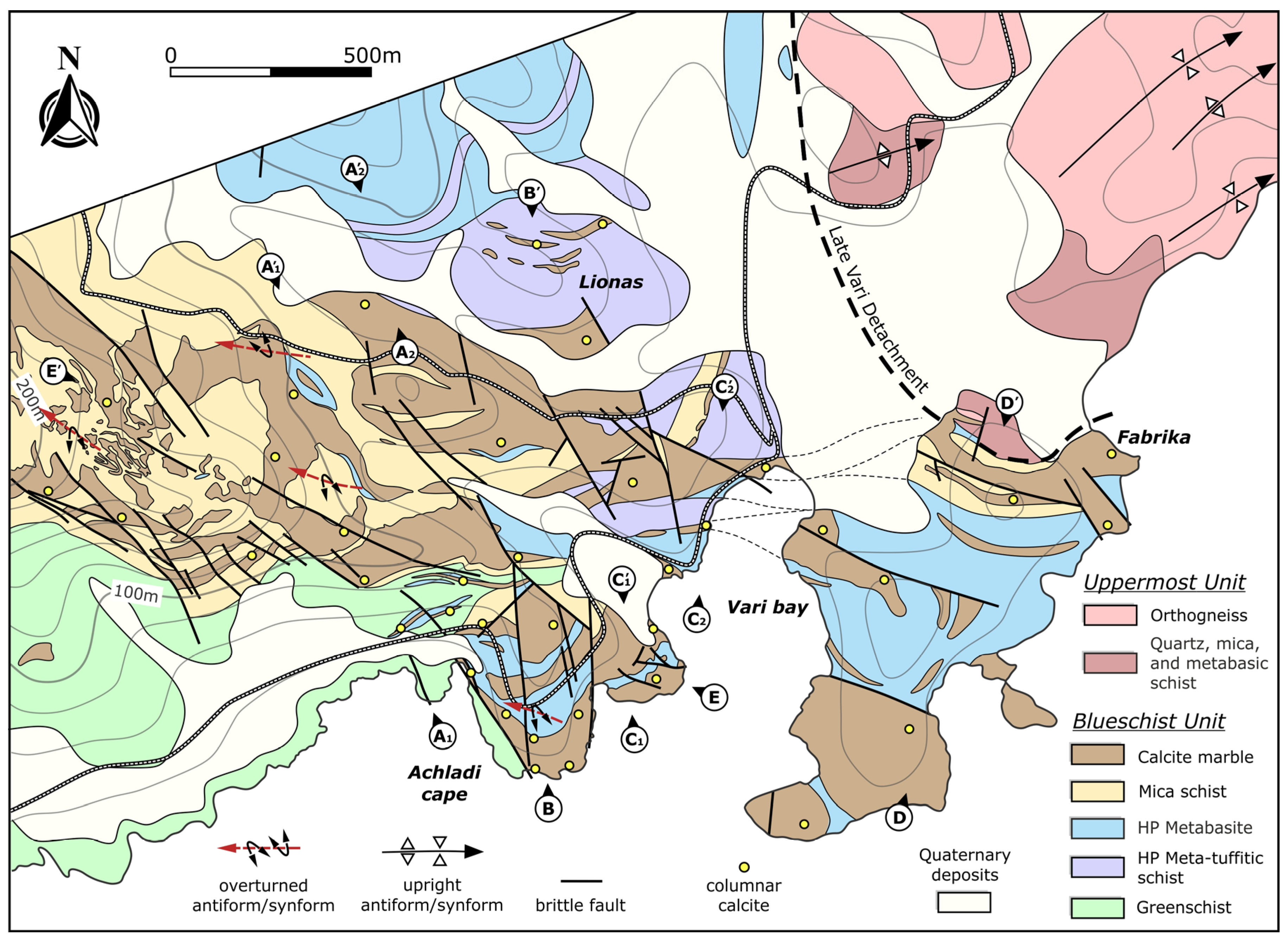
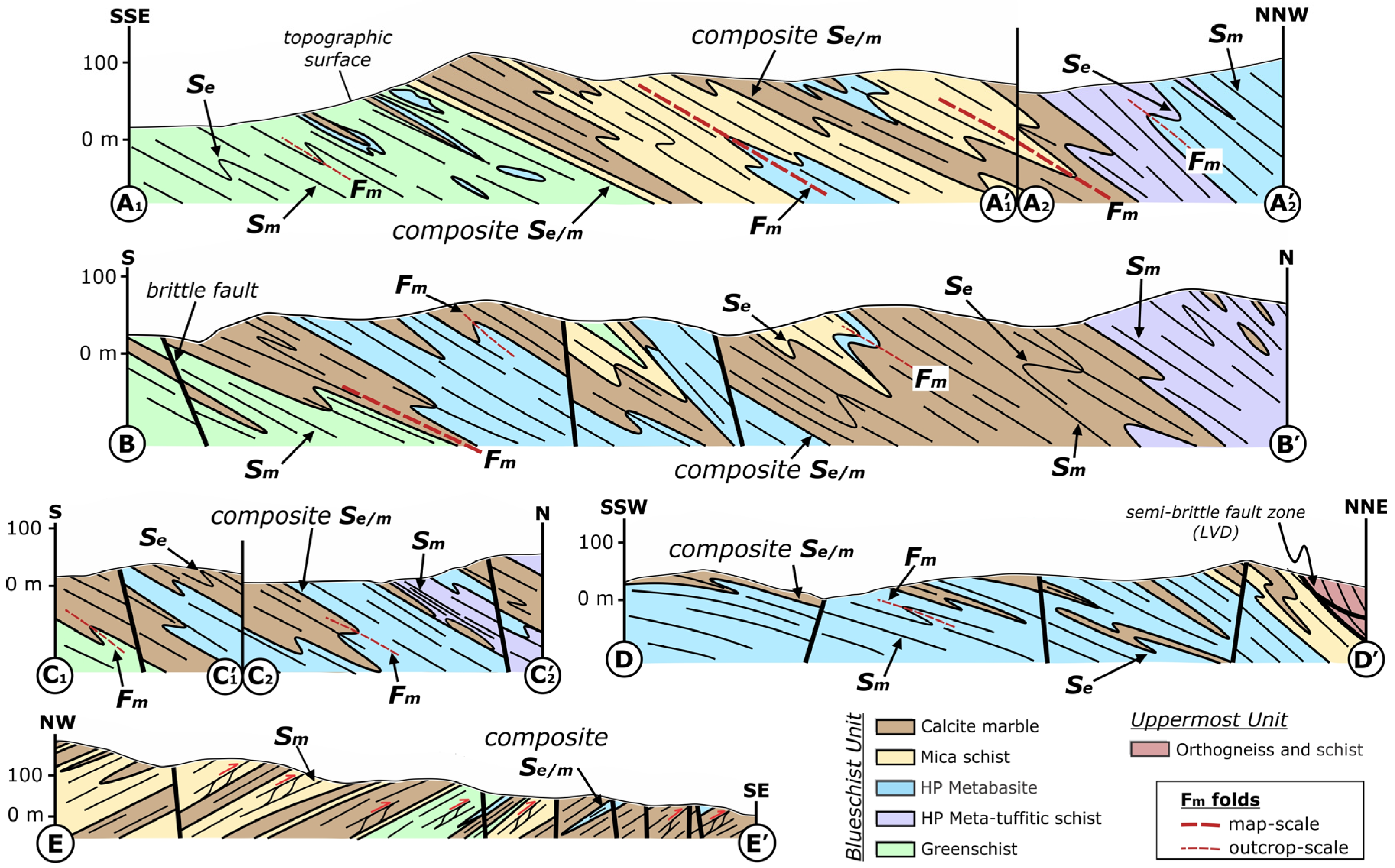
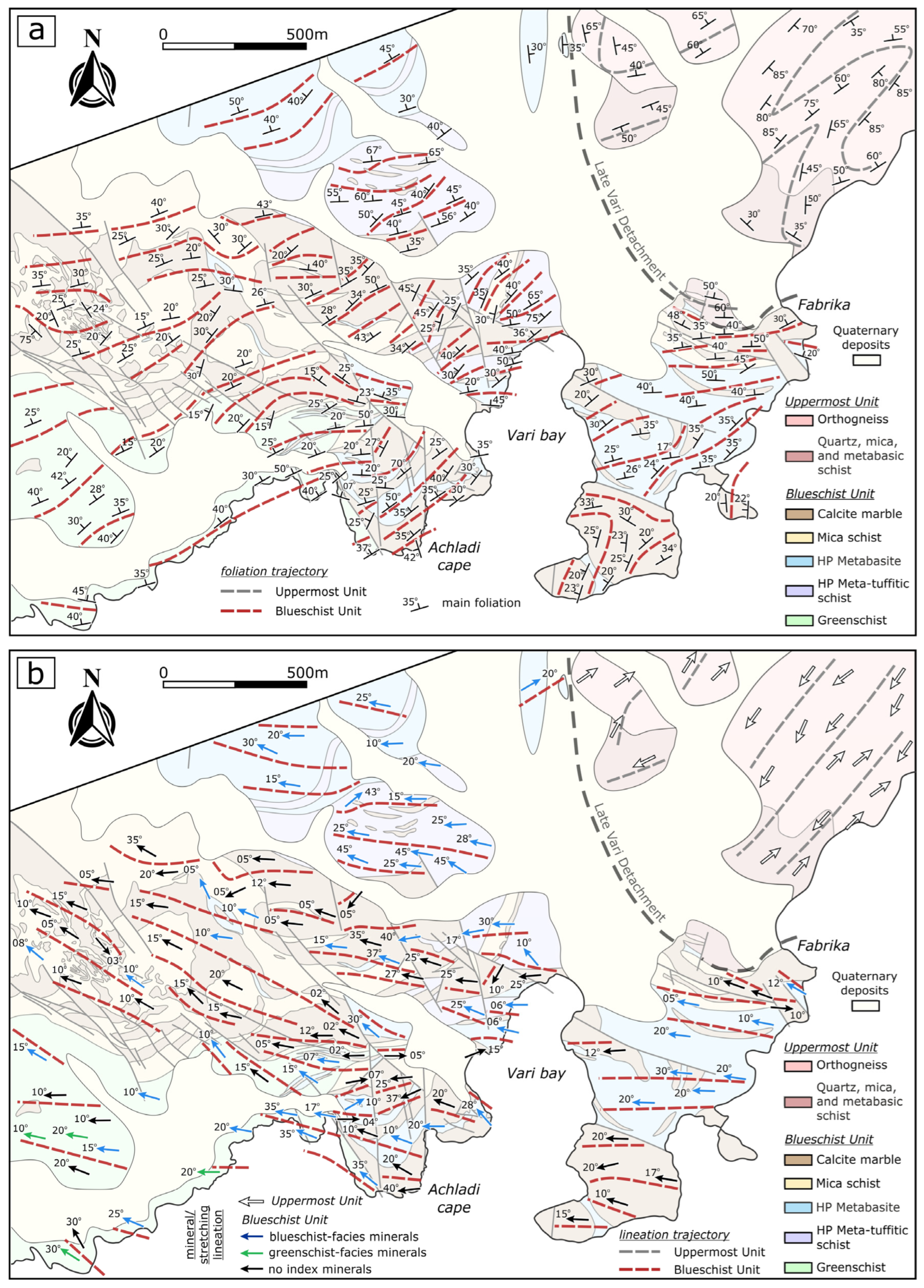
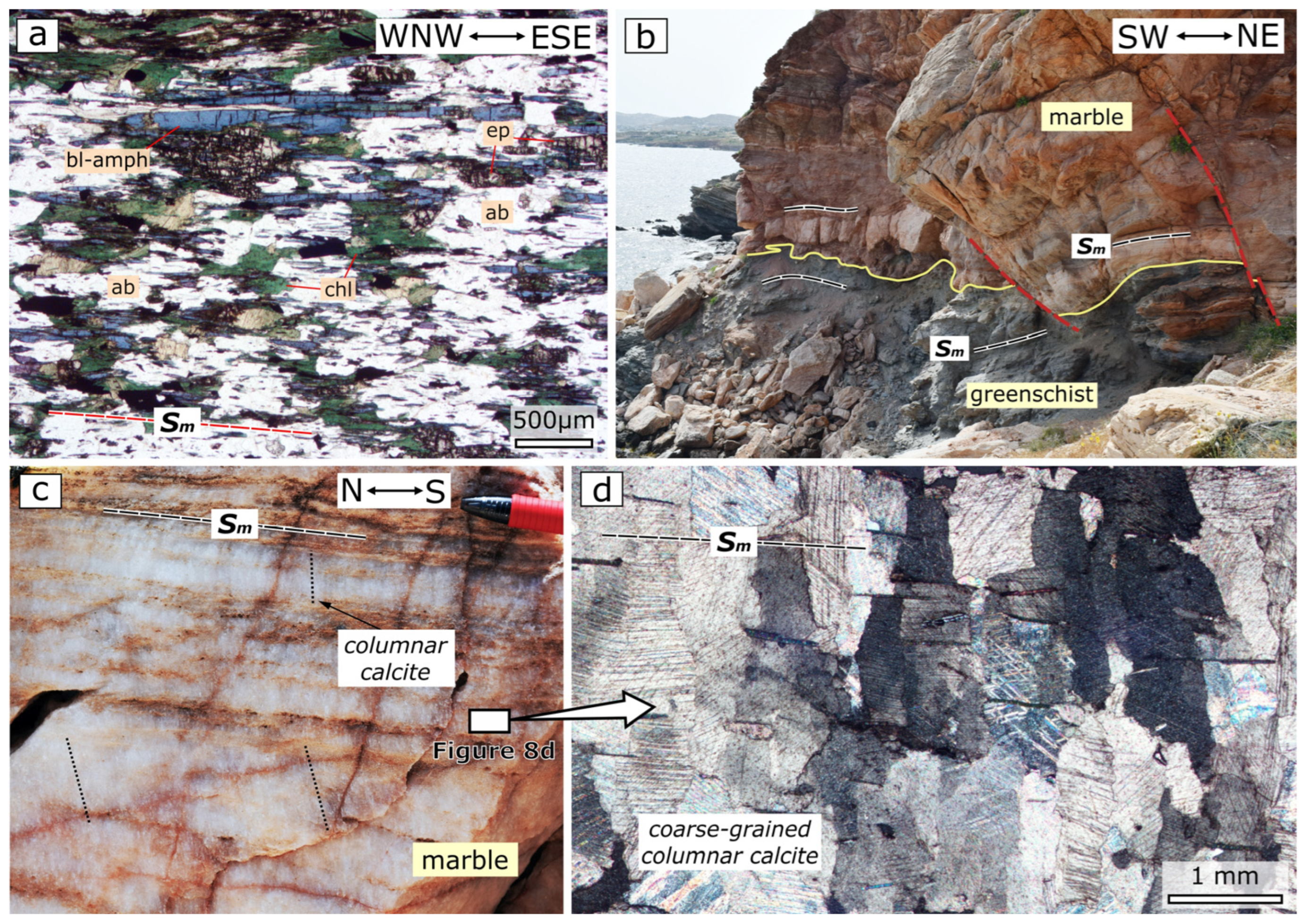
3.1. Mapping Results

Geological mapping led us to classify the rocks of the Blueschist Unit exposed in SE Syros into five main groups based on lithological and metamorphic criteria. The rock groups presented in this study are in general accordance with the categorization of Keiter et al. (2011) [2]. These rock groups include calcite marble, mica schist, HP metabasite, HP meta-tuffitic schist, and greenschist (Figure 2). The calcite marble group is mainly composed of calcite marbles, which are commonly characterized by the presence of non-mappable dolomitic marble layers/lenses and bands of calcite and mica schists of a few centimeters up to ca. 5 m in thickness. The mica schist group is made up of mica schists, which alternate from the outcrop scale to the map scale with calcite and quartz schists (Figure 2). Generally, the contacts between different schists are blurred and, in some cases, gradational, whereas calcite schists typically occur in close contact with calcite marbles. It is noted that diagnostic minerals of eclogite-/blueschist-facies metamorphism, such as blue amphibole and garnet, are typically present in the main parageneses of the mica schist rock group. HP metabasite consists of eclogite, glaucophanite, and blueschist alternating in outcrop scale. Eclogite typically occurs as lenses/pods within glaucophanite/blueschist. In a few cases, eclogite and glaucophanite pods were recognized within calcite schist close to contacts with calcite marble. HP metabasites are commonly characterized by the minor presence of retrograde minerals such as chlorite, epidote, and green amphibole. HP meta-tuffitic schist is composed of banded mafic and felsic layers alternating on scales from a centimeter to several meters. Mafic bands typically contain blue amphibole and garnet, whereas felsic bands are composed of feldspar, quartz, and white mica. The greenschist group comprises mainly greenschist, epidote schist, albite-bearing greenschist, epidotite, and minor chlorite schist. Locally (e.g., west of the Achladi cape), bands of quartzofeldspathic schist and felsic gneiss up to about 3 m thick are interleaved with greenschist and epidote schist (Figure 2). These alternations seem to be the retrograde equivalent of the HP meta-tuffitic schist rock group. Our geological mapping revealed that the Uppermost Unit is mainly composed of orthogneiss, quartz, mica, and metabasic schist in agreement with the findings of previous studies [11] (Figure 2).
The larger part of the study area is occupied by rocks of the Blueschist Unit, whereas the Uppermost Unit is restricted to the northeastern part. Specifically, rocks of the calcite marble and mica schist groups mainly occupy the central part of the study area, roughly defining a (W)NW-trending zone (Figure 2). Along this zone, these rocks are dominant towards the NW, with only minor mappable exposures of HP metabasites, whereas moving southeastwards, larger exposures of HP metabasites are recorded (Figure 2). Rocks of the HP metabasite and meta-tuffitic schist generally occupy the northern and parts of the eastern part of the map, whereas rocks of the greenschist group are restricted to the southwestern part of the map (Figure 2). Note that occurrences of outcrop-scale to map-scale well-preserved HP metabasites were recorded within the greenschist group, implying that these rocks escaped the greenschist-facies retrogression (Figure 2 and Figure 3). Rocks of all groups display outcrop-scale to map-scale alternations and in some cases show an interfingering pattern on the map (Figure 2, Figure 3 and Figure 4). Additionally, our geological mapping indicates that rocks of the greenschist group are not restricted to the lowest structural levels of the rock sequence exposed in SE Syros, but passed laterally northeastwards within marbles and HP metabasites (e.g., north of the Achladi cape) (Figure 2). In this area, greenschists are sandwiched between rocks of the calcite marble and HP metabasite groups (Figure 2 and Figure 3: B–B′ and E–E′).

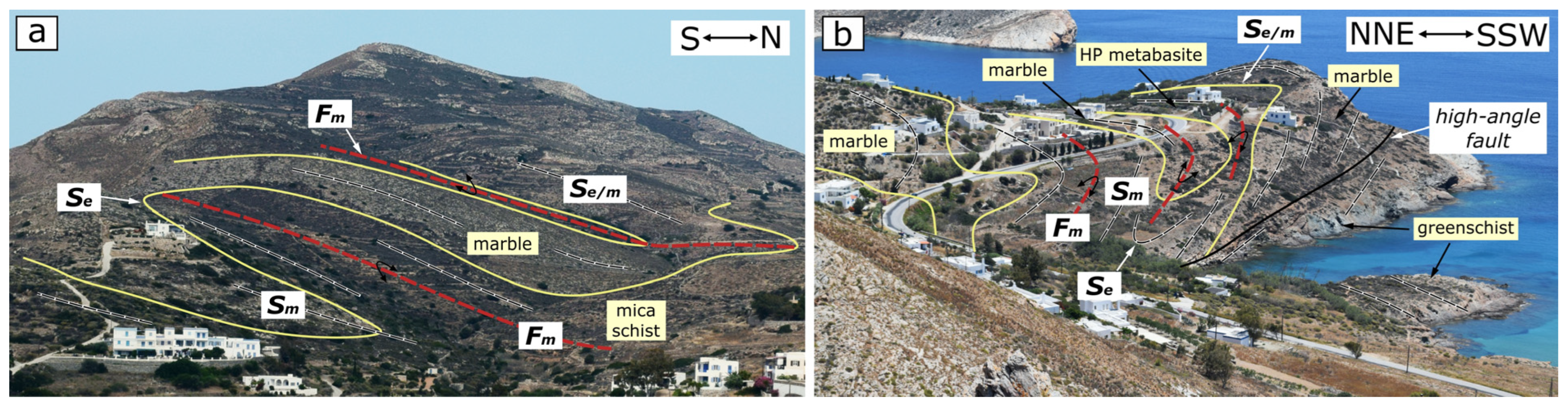
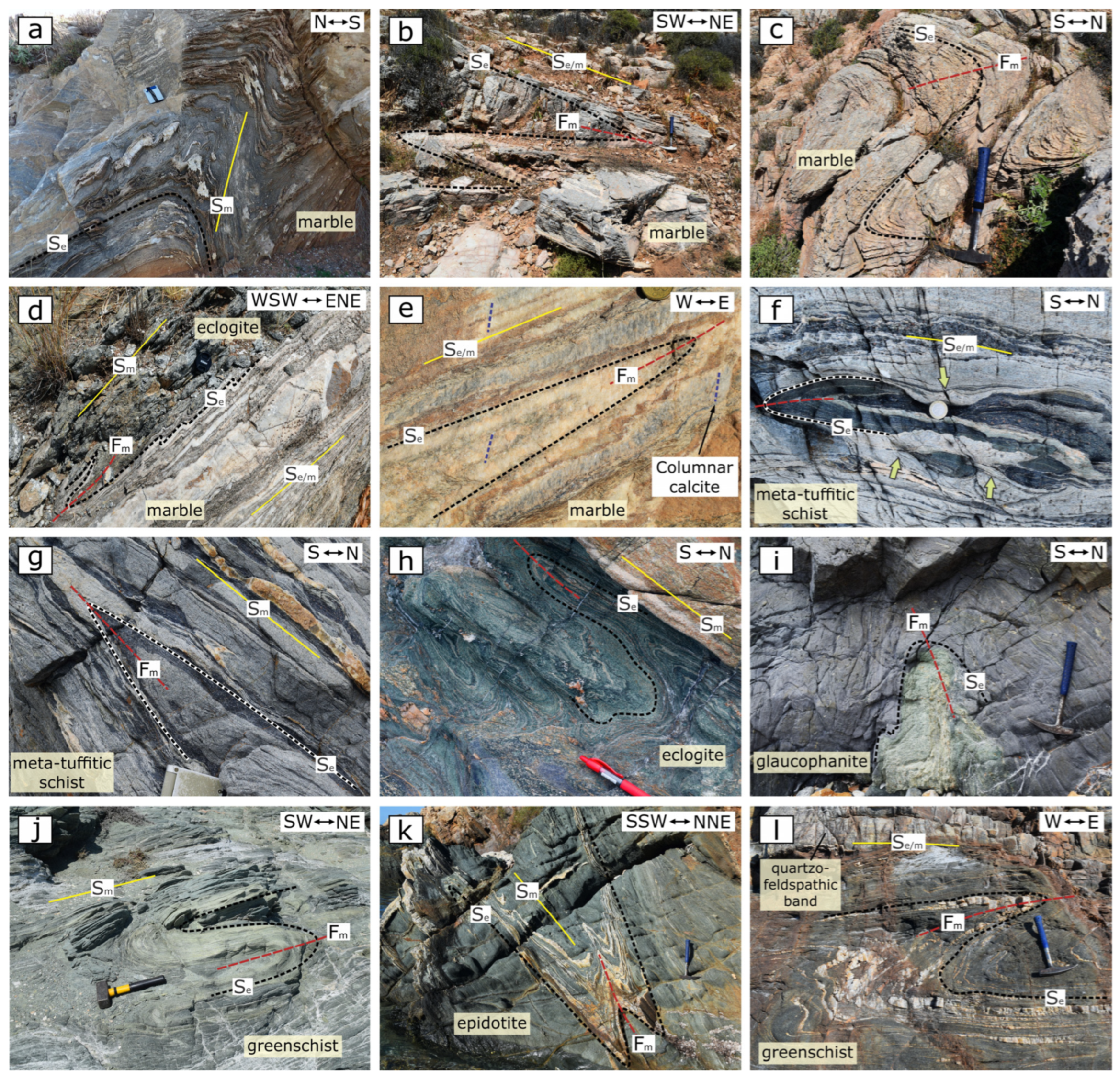
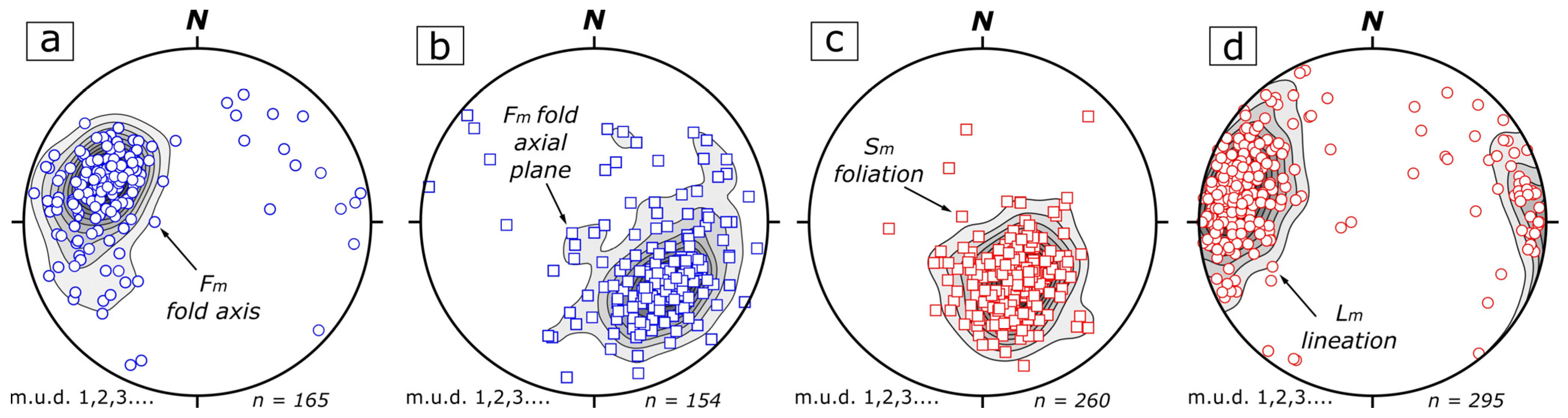
3.2. Structural Analysis

Structural analysis reveals that rocks of the Blueschist Unit were affected by a main deformation phase (Dm). A common structural feature of a Dm is the abundant occurrence of close-to-isoclinal folds (Fm) (Figure 3). Fm folds are observed at various scales, from outcrop scale to map scale, deforming an early Se foliation, which is mainly recognizable in the fold hinges (Figure 3, Figure 4a,b and Figure 5a–l). The identification of map-scale Fm folds is not always straightforward due to their tightness. Alternations between the rocks or termination of a rock layer does not exclusively indicate the presence of a fold hinge, as these features could be interpreted as the result of either primary relationships or boudinage. However, some such map-scale Fm folds were mapped with relative confidence by combining marker horizons (i.e., rock contacts), the vergence of associated outcrop-scale parasitic folds, and the extensive occurrence of outcrop-scale folds in areas where a rock layer terminates (Figure 2, Figure 3 and Figure 4). Map-scale Fm folds vary in tightness, from tight to isoclinal (Figure 3 and Figure 4), whereas they trend generally WNW-ESE with moderately inclined axial planes (Figure 2 and Figure 3). Folding during Dm also produced a plethora of close-to-isoclinal outcrop-scale parasitic Fm folds (Figure 5). These folds generally have shallow-to-moderately (mean plunge 40°) W- to NW-plunging axes, with a mean WNW orientation (mean orientation 295°) (Figure 6a). Fm fold axial planes typically dip moderately (mean dip 45°) towards NW (mean orientation 310°) (Figure 6b). Fm folds are characterized as moderately-inclined-to-reclined in style, as, in several outcrops, the pitch of the hinge line on the axial plane is greater than 80° [39]. The observed outcrop- to map-scale Fm folds deform the contacts between different rock groups (Figure 4 and Figure 5d). It is noted that outcrop-scale Fm folds are also abundant within the rocks of the greenschist group, displaying similar tightness and orientation (Figure 5j–l).
The main Dm phase is also characterized by the development of an Sm planar fabric, which is typically axial planar to the Fm folds (Figure 3 and Figure 5). This main foliation has also been reported in previous studies focused on SE Syros [2,9,13]. Sm varies in intensity, from crenulation cleavage to a mylonitic foliation, but it is typically observed as a well-developed foliation. In competent lithologies such as eclogites or within rocks that were not strongly affected by Dm phase, Sm is weakly developed or absent (Figure 5c,i). Sm generally dips moderately towards NW to N, with the trajectories displaying, in map-view, a generally NE-SW orientation (Figure 6c and Figure 7a). However, in various locations, Sm is characterized by a more E-W orientation. Sm foliation is typically defined by mineral aggregates such as quartz, calcite, epidote, and omphacite, as well as by pervasive alignment of blue amphibole and white mica flakes, depending on the rock type.
The Sm clearly transposes the early Se foliation within Fm hinge zones, whereas on the limbs of tight-to-isoclinal folds, Sm and Se are indistinguishable from one another due to their coplanarity and thus are considered as a composite Se/m foliation (Figure 3 and Figure 5). This composite Se/m foliation typically marks the contacts between different rock groups (Figure 3). In close Fm folds, Sm is aligned with the axial planes transposing the early Se foliation in both the fold hinges and the limbs (Figure 5a). Within the Sm foliation planes, a well-developed mineral/stretching lineation (Lm) was recognized. This lineation has also been reported from previous studies in SE Syros [9]. Lm lineation is also recognized within the composite Se/m foliation planes, revealing that the Se foliation has been reused by the Dm deformation. Within both Sm and Se/m, Lm is defined by aligned blue amphibole needles, streaky micas, and epidote, quartz, and calcite aggregates. Lm mainly plunges shallowly to moderately W to NW, with a mean plunge 20° toward 290° (Figure 6d) oriented subparallel or at small angles to the Fm fold axes (Figure 6). In a few sites, a NE-trending mineral/stretching lineation coexisting with the dominant WNW-trending lineation is also recorded. This secondary lineation orientation is defined by the same minerals as define the main Lm lineation orientation. On the map, Lm lineation orientation does not present any significant spatial variation, presenting instead a general W- to NW-trending orientation, with a typical WNW-trending orientation (Figure 7b). Lineation is defined by syn-blueschist facies minerals, in most cases blue amphibole, within HP metabasites and meta-tuffitic schists, as well as within mica schists (Figure 7b). Syn-blueschist facies lineation is typically recorded in rocks of the greenschist group, especially those moving northeastwards close to points of contact with rocks of the other groups (Figure 7b and Figure 8a,b). Within these greenschists, the presence of large albite grains with straight blue amphibole inclusion trails oriented parallel to the external foliation is typical (Figure 8a). Diagnostic minerals of greenschist-facies metamorphism such as chlorite typically fill the gaps between albite grains, and they are not aligned with the foliation (Figure 8a). In turn, syn-greenschist-facies lineation is observed only in some outcrops located in the southwestern parts of the greenschist rock group (Figure 7b).
As mentioned above, the intensity of Sm varies from crenulation cleavage to a mylonitic foliation. Mylonites are typically a few meters in thickness and are observed at various structural levels and within all rock groups, where they do not systematically define the contacts between different lithologies. Also, it is noted that there is no significant localization of Dm within the greenschist rock group. In sites where Sm is well-developed to mylonitic, a variety of shear sense indicators were recorded, typically including C- and C′-type shear bands, sigmoids, and garnet porphyroclasts (Figure 9a–c). These indicators display a consistent top-to-ESE to -E shearing. An opposite top-to-WNW shearing is observed in only one site within meta-tuffitic schists located at the coastline west of the Vari bay.
Structures of the main Dm deformation phase are, locally, overprinted by boudinages and semi-ductile-to-brittle shear bands displaying asymmetry towards the NE. These structures were recorded within all rock groups except mica schists (Figure 5f). Also, throughout the study area, calcite marbles are characterized by the presence of columnar calcite oriented at high angles to both the Sm foliation and the Fm axial planes (Figure 2, Figure 5e and Figure 9b). It is noted that well-preserved columnar calcite is also observed in outcrop- to map-scale bands and that lenses of calcite marble occurred within the greenschist rock group, as well as in the thick block of calcite marble at the ductile-related contact with the rocks of the greenschist group (Figure 2 and Figure 8b–d). Finally, all the above-mentioned ductile structures were affected by high-angle brittle faults, which strike mainly NW-SE and typically display strike-slip or normal movements (Figure 2 and Figure 3) (see Keiter et al. (2011) [2] for a detailed description).
Our results from the structural analysis of the Uppermost Unit are in accordance with the results of previous work [11]. Specifically, orthogneisses are manifested by outcrop-scale to map-scale cylindrical folds, which deform the main foliation (Figure 7a). These folds are commonly upright and show open to close geometries. The fold hinges typically plunge moderately towards the NE, while the associated axial planes strike NE-SW (Figure 2). Close to the contact with the Blueschist Unit, upright folds are transposed by a gently NE-dipping mylonitic foliation displaying a SW-directed sense of shear, which has been related to the ductile Vari Detachment according to Aravadinou & Xypolias (2017) [11]. A strongly developed stretching lineation trending NE-SW parallel to the fold hinges is also observed (Figure 7b). Lineation is oriented almost perpendicular to the Lm lineation recorded within the underlying Blueschist Unit (Figure 7b). The contact between the Uppermost and Blueschist units is observed near the Fabrika area and is marked by a major top-to-the-SSW semi-brittle-to-brittle fault zone, the Late Vari Detachment, as has also been described by Aravadinou & Xypolias (2017) [11] (Figure 2 and Figure 3).

4. Discussion

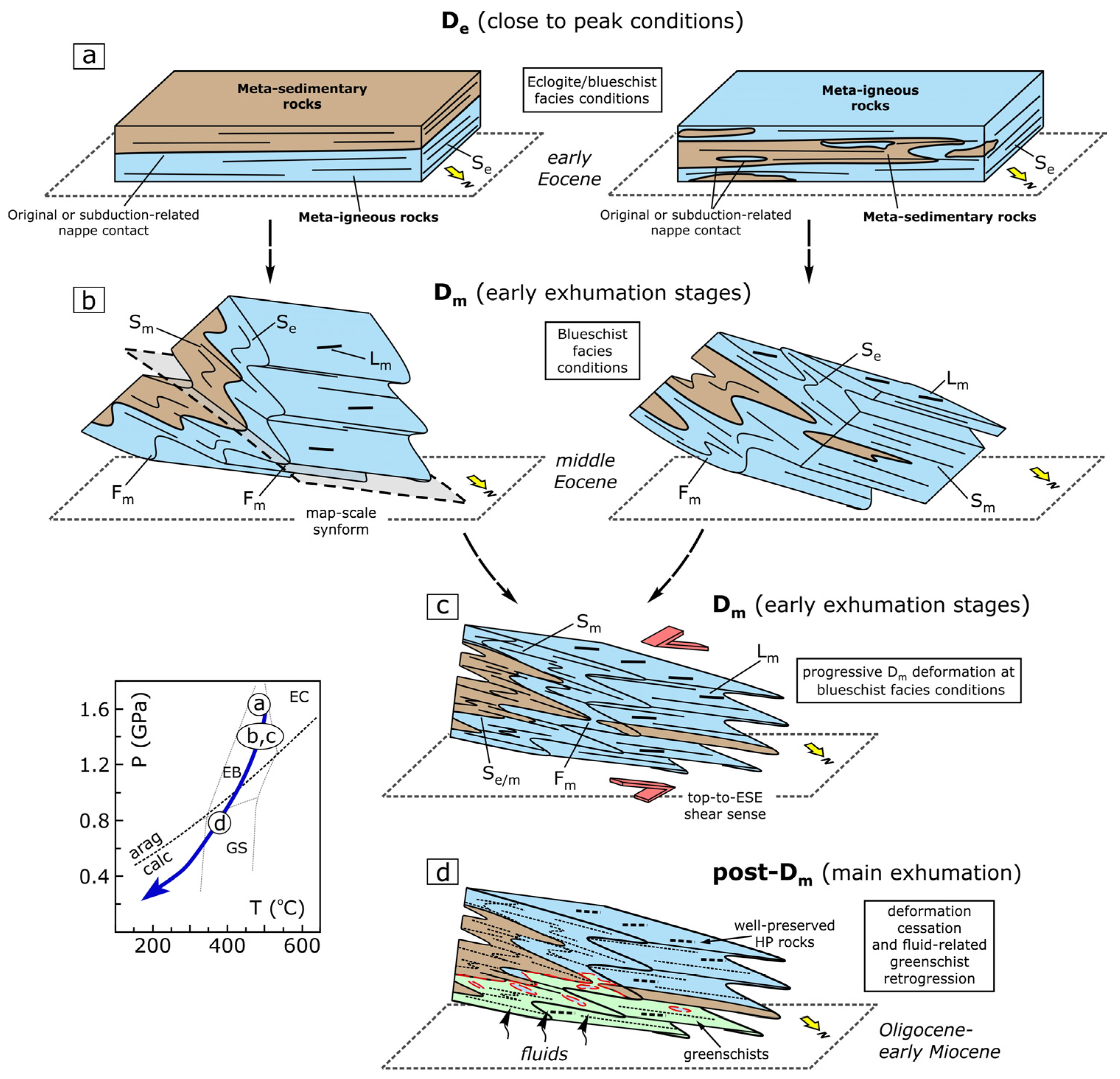
4.1. Structural Evolution of SE Syros

Geological/structural mapping revealed that the rock groups exposed in the southeast part of Syros Island can be grouped into two main sequences based on the lithology’s protolith, the meta-sedimentary sequence, and the meta-igneous sequence (Figure 2 and Figure 3). The meta-sedimentary sequence includes calcite marble and mica schist rock groups, whereas the meta-igneous sequence includes the HP metabasite, HP meta-tuffitic schist, and greenschist rock groups (Figure 2). It is noted that greenschist rock group was included in the meta-igneous sequence because, in the study area, they are mainly locally represented by metabasic rocks (west of the Achladi cape) alternated with quartzofeldspathic/gneissic bands, which are possibly the equivalent of the HP meta-tuffitic schists occurring in the northern part of the area (Figure 2). Also, locally within the greenschists, HP metabasic rocks were preserved, revealing that this group was also originally metamorphosed under blueschist-facies conditions. This interpretation is also supported by the observations of Keiter et al. (2011) [2], suggesting that the greenschists are at least partially magmatic in origin. Rocks of the meta-sedimentary sequence roughly define a (W)NW-trending zone, which widens towards the NW, surrounded by rocks of the meta-igneous sequence (Figure 2). In map-view, the spatial alternation of the two sequences, combined with the observed interfingering patterns of the rocks at smaller scales, could be related either to large-scale folding or to a primary protolith relationship (Figure 2 and Figure 3). In the first case, the alternations on the map, coupled with the observed WNW-plunging fold axes, suggest the occurrence of a major synformal structure wherein the meta-sedimentary sequence should occupy the core of the megastructure. Thus, in the early (pre-Dm) tectonostratigraphic succession, the meta-igneous should be overlain by the meta-sedimentary sequence (Figure 10a). If the alternations are the result of primary relationships, then the early tectonostratigraphic succession should have included a meta-sedimentary sequence sandwiched between meta-igneous rocks (Figure 10a).
Structural analysis indicates an early Se foliation recognizable in rocks of both sequences, including eclogites (Figure 10a). Considering that the subsequent main Dm phase occurred under blueschist-facies conditions and is related to folding and transposition of the Se foliation in eclogites, the Se foliation should have formed under eclogite/blueschist-facies conditions, which roughly corresponds to peak conditions (Figure 10: PT diagram). Geochronological data from Syros indicate that the rocks attained peak conditions of 1.5–2.1 GPa and 500–580 °C ca. 53–48 Ma [22,24,28,29].
The early succession displaying the early Se foliation was folded by outcrop- to map-scale, moderately-inclined-to-reclined (Fm) folds oriented (sub)parallel to WNW-trending mineral/stretching lineation (Lm) (Figure 3 and Figure 9b). Structural analysis revealed a plethora of outcrop-scale Fm folds, which are either parasitic folds in a mega-scale synformal structure causing the repetition of the original succussion or folds that deform the original sandwiched succession without being related to any megastructure (Figure 10b). These outcrop-scale Fm folds are linked with the development of an axial planar Sm foliation, which transposes or is coplanar to the early Se, forming a composite Se/m foliation (Figure 10c). Our new detailed structural mapping of the Lm mineral/stretching lineation suggests a dominant WNW-ESE orientation, which is associated with a consistent top-to-the E(SE) shearing (Figure 10c). Sm, composite Se/m and Lm are defined by, among other features, blue amphibole needles, implying that the main deformation phase (Dm) took place under blueschist-facies conditions. A similar top-to-the-(E)SE sense of shear has also been reported in mylonitic rocks exposed in north Syros, as well as in other Cycladic Islands such as Evia, Sifnos, and Andros. This shear was interpreted as having occurred under blueschist-facies conditions during the early stages of exhumation [12,16,18,40]. As was suggested in these studies, Dm deformation in SE Syros should have occurred at the early stages of exhumation under blueschist-facies conditions. In SE Syros, exhumation of the rocks under blueschist-facies conditions has been dated to 41–37 Ma [22].
The extensive preservation of columnar calcite grains within calcite marbles throughout the study area indicates that deformation was very weak or absent during exhumation of the rocks from blueschist to greenschist-facies conditions (see also [7,12,38]) (Figure 10d). Growth of this columnar microstructure has been interpreted as having occurred within the aragonite stability field during (nearly) static conditions (see also [12,38,41]), revealing that Dm phase should have ceased when the rocks were still under blueschist-facies conditions (Figure 10: PT diagram). The cessation of deformation at deep subduction levels (blueschist facies conditions) is also indicated by the recorded differences in structure orientations between the rocks of the Blueschist and the Uppermost Unit (Figure 7a,b). Specifically, the dominant ESE-WNW orientation recorded within the Blueschist Unit is almost normal to the NE-SW orientation observed in the rocks of the Uppermost Unit ([11]; this study). NE-SW orientation within the Uppermost Unit has been linked with the NE-directed extrusion of the Blueschist from blueschist to greenschist-facies conditions (main exhumation) [11]. Dominant ESE-directed shearing recorded within the rocks of the Blueschist Unit in SE Syros implies that they have not recorded the deformation associated with the main exhumation of the unit, further supporting the assumption that these rocks were exhumed as a nearly rigid body from blueschist to greenschist-facies conditions. Post-Dm deformation during the main exhumation of the rocks should be locally expressed in top-to-(E)NE asymmetric boudinage and shear bands (see also [36]).

4.2. Is the Greenschist Overprint Related to the Formation of a Crustal-Scale Shear Zone?

A crucial question that arises from the results of previous studies in SE Syros [9,13,35] is whether the greenschist retrogression recorded in the southwestern part of the study area is linked with intense deformation and formation of a crustal-scale shear zone at the point of contact between greenschists and rocks of the meta-sedimentary sequence (Figure 1: Achladi Detachment of Laurent et al. 2016 [9]). Our geological/structural mapping, coupled with our detailed structural analysis, showed (a) the extensive occurrence of columnar calcite within map-scale to outcrop-scale marble exposures in contact with greenschists (Figure 2 and Figure 8b–d) (if greenschist retrogression were related to intense deformation, then columnar calcite should be obliterated due to dynamic recrystallization); (b) the absence of both Sm and post-Sm mylonites and strain localization at the point of contact between rocks of the meta-sedimentary sequence and greenschists (Figure 3); (c) the preservation of the Dm structures and fabrics orientation (i.e., foliation, lineation, and fold axis orientation) within greenschists (Figure 5 and Figure 7); (d) the presence of preserved blue amphibole needles defining the lineation within greenschists (Figure 7b and Figure 8a); and (e) the presence of albite-bearing schists within the greenschist group, especially close to the contact with the rocks of the meta-sedimentary sequence. Note that our microstructural observations indicate that albite growth took place within greenschist-facies conditions under no significant deformation (Figure 8a) similar to the interpretation of Barr (1989) [35]. All the above-mentioned evidence supports the interpretation that the greenschist overprint probably took place under nearly static conditions, rather than under intense deformation. Thus, the rocks of the greenschist group should share a common deformation history with the well-preserved HP rocks (Figure 10d). All this evidence also shows that the contact between greenschists and rocks of the meta-sedimentary sequence should have not been marked by a major syn-greenschist shear zone, in contrast with the findings of previous studies (e.g., [9]). Syn-greenschist deformation dated between 35 and 18 Ma [22] is possibly localized within narrow zones at lower structural levels of the greenschists or in other areas of Syros Island (see for example [9]). Syn-greenschist deformation localized within narrow zones cannot alone explain the pervasive transition from blueschists to greenschists in the southwestern part of the study area. This transition was probably controlled by other factors, such as the presence of fluids, as has also been proposed by previous studies [35,36] (Figure 10d). Barr (1989) [35] has suggested that the marbles acted as barriers to upwards-moving fluids, causing lateral flow of fluids along their contact with the underlying schists and thus producing the present-day near-sharp transition between greenschists and marbles/mica schists. A similar interpretation has also been suggested for the preservation of HP rocks of the Blueschist Unit on the neighboring island of Sifnos [42]. Our results further enhance this interpretation, emphasizing the need for more studies of the greenschist rock group, especially at the areas near its upper contact with the preserved HP rocks, to better understand the role of deformation during the greenschist overprint on an island scale.

5. Conclusions

Detailed geological/structural mapping and field-based structural analysis in SE Syros enabled us to produce a new geological/structural map on a scale of 1:5000 and to describe the tectono-metamorphic evolution of the rocks. The five main rock groups that were mapped can be categorized into two sequences based on their protoliths, namely the metasedimentary and the meta-igneous sequences. In map-view, the meta-sedimentary sequence is sandwiched between rocks of the meta-igneous sequence, implying either primary interfingering relationships or map-scale folding during exhumation. Our results indicate that the Blueschist Unit was affected by distributed pervasive deformation (Dm) linked with the formation of WNW-plunging folds and an ESE-directed shearing that occurred under blueschist-facies conditions during the early exhumation stages. Subsequent main exhumation of the rocks from blueschist to greenschist-facies conditions was generally associated with very weak or no deformation. Greenschist retrogression observed in the lower structural levels of the Blueschist Unit was mainly controlled by the presence of fluids under partly static conditions, with syn-greenschist deformation localized within narrow zones at the lower structural levels of the greenschists.

Author Contributions

Conceptualization, N.G., E.A. and P.X.; Investigation, N.G., E.A. and P.X.; Formal analysis, N.G.; Visualization, N.G and E.A.; Validation, E.A. and P.X.; Supervision, P.X.; Writing—original draft, N.G.; Writing—review & editing, E.A. and P.X. All authors have read and agreed to the published version of the manuscript.

Funding

This research received no external funding.

Data Availability Statement

The data are contained within the article.

Acknowledgments

We would like to thank the academic editor Olivier Lacombe for editorial handling, as well as two anonymous reviewers for their constructive comments, which helped improve the manuscript. The publication fees of this manuscript have been financed by the Research Council of the University of Patras.

Conflicts of Interest

The authors declare no conflict of interest.

References

  1. Okrusch, M.; Bröcker, M. Eclogites associated with high grade blueschists in the Cyclades archipelago, Greece: A review. Eur. J. Mineral. 1990, 2, 451–478. [Google Scholar] [CrossRef]
  2. Keiter, M.; Ballhaus, C.; Tomaschek, F. A New Geological Map of the Island of Syros (Aegean Sea, Greece): Implications for Lithostratigraphy and Structural History of the Cycladic Blueschist Unit; Geological Society of America: Boulder, CO, USA, 2011; Special Paper 481; 43p. [Google Scholar]
  3. Trotet, F.; Jolivet, L.; Vidal, O. Tectonometamorphic evolution of Syros and Sifnos islands (Cyclades, Greece). Tectonophysics 2001, 338, 179–206. [Google Scholar] [CrossRef]
  4. Rosenbaum, G.; Avigad, D.; Sánchez-Gómez, M. Coaxial flattening at deep levels of orogenic belts: Evidence from blueschists and eclogites on Syros and Sifnos (Cyclades, Greece). J. Struct. Geol. 2002, 24, 1451–1462. [Google Scholar] [CrossRef]
  5. Keiter, M.; Piepjohn, K.; Ballhaus, C.; Lagos, M.; Bode, M. Structural development of high-pressure metamorphic rocks on Syros island (Cyclades, Greece). J. Struct. Geol. 2004, 26, 1433–1445. [Google Scholar] [CrossRef]
  6. Schumacher, J.C.; Brady, J.B.; Cheney, J.T.; Tonnsen, R.R. Glaucophane-bearing marbles on Syros, Greece. J. Petrol. 2008, 49, 1667–1686. [Google Scholar] [CrossRef]
  7. Schumacher, J.C.; Brady, J.B.; Cheney, J.T. Metamorphic style and development of the blueschist- to eclogite-facies rocks, Cyclades, Greece. IOP Conf. Ser. Earth Environ. Sci. 2008, 2, 012017. [Google Scholar] [CrossRef]
  8. Soukis, K.; Stockli, D.F. Structural and thermochronometric evidence for multi-stage exhumation of Southern Syros, Cycladic islands, Greece. Tectonophysics 2013, 595, 148–164. [Google Scholar] [CrossRef]
  9. Laurent, V.; Jolivet, L.; Roche, V.; Augier, R.; Scaillet, S.; Cardello, G.L. Strain localization in a fossilized subduction channel: Insights from the Cycladic Blueschist Unit (Syros, Greece). Tectonophysics 2016, 672–673, 150–169. [Google Scholar] [CrossRef]
  10. Laurent, V.; Huet, B.; Labrousse, L.; Jolivet, L.; Monié, P.; Augier, R. Extraneous argon in high-pressure metamorphic rocks: Distribution, origin and transport in the Cycladic Blueschist Unit (Greece). Lithos 2017, 272–273, 315–335. [Google Scholar] [CrossRef]
  11. Aravadinou, E.; Xypolias, P. Evolution of a passive crustal-scale detachment (Syros, Aegean region): Insights from structural and petrofabric analyses in the hanging-wall. J. Struct. Geol. 2017, 103, 57–74. [Google Scholar] [CrossRef]
  12. Aravadinou, E.; Gerogiannis, N.; Xypolias, P. Development and passive exhumation of high-pressure shear zones (Blueschist Unit, Syros): Insights from quartz and columnar calcite microstructures. J. Struct. Geol. 2022, 159, 104607. [Google Scholar] [CrossRef]
  13. Kotowski, A.J.; Behr, W.M.; Cisneros, M.; Daniel, F.; Soukis, K.; Barnes, J.D.; Ortega Arroyo, D. Subduction, underplating, and return flow recorded in the Cycladic Blueschist Unit exposed on Syros, Greece. Tectonics 2022, 41, e2020TC006528. [Google Scholar] [CrossRef]
  14. Jolivet, L.; Brun, Ζ.J.P. Cenozoic geodynamic evolution of the Aegean. Int. J. Earth Sci. 2010, 99, 109–138. [Google Scholar] [CrossRef]
  15. Xypolias, P.; Kokkalas, S.; Skourlis, K. Upward extrusion and subsequent transpression as a possible mechanism for the exhumation of HP/LT rocks in Evia Island (Aegean Sea, Greece). J. Geodyn. 2003, 35, 303–332. [Google Scholar] [CrossRef]
  16. Xypolias, P.; Iliopoulos, I.; Chatzaras, V.; Kokkalas, S. Subduction- and exhumation-related structures in the Cycladic blueschists: Insights from south Evia island (Aegean region, Greece). Tectonics 2012, 31, TC2001. [Google Scholar] [CrossRef]
  17. Ring, U.; Glodny, J.; Will, T.; Thomson, S.N. An Oligocene extrusion wedge of blueschist-facies nappes on Evia, Aegean Sea, Greece: Implications for the early exhumation of high-pressure rocks. J. Geol. Soc. Lond. 2007, 164, 637–652. [Google Scholar] [CrossRef]
  18. Gerogiannis, N.; Xypolias, P.; Chatzaras, V.; Aravadinou, E.; Papapavlou, K. Deformation within the Cycladic subduction-exhumation channel: New insights from the enigmatic Makrotantalo nappe (Andros, Aegean). Int. J. Earth Sci. 2019, 108, 817–843. [Google Scholar] [CrossRef]
  19. Ring, U.; Pantazides, H.; Glodny, J.; Skelton, A. Forced return flow deep in the subduction channel, Syros, Greece. Tectonics 2020, 39, e2019TC005768. [Google Scholar] [CrossRef]
  20. Dürr, S. Das Attisch-Kykladische Kristallin. In Geologie von Griechenland; Jacobshagen, V., Ed.; Bornträger: Berlin, Germany, 1986; pp. 116–148. [Google Scholar]
  21. Uunk, B.; Brouwer, F.; de Paz-Álvarez, M.; van Zuilen, K.; Huybens, R.; van ’t Veera, R.; Wijbrans, J. Consistent detachment of supracrustal rocks from a fixed subduction depth in the Cyclades. Earth Planet. Sci. Lett. 2022, 584, 117479. [Google Scholar] [CrossRef]
  22. Laurent, V.; Scaillet, S.; Jolivet, L.; Augier, R.; Roche, V. 40Ar behaviour and exhumation dynamics in a subduction channel from multi-scale 40Ar/39Ar systematics in phengite. Geochim. Cosmochim. Acta 2021, 311, 141–173. [Google Scholar] [CrossRef]
  23. Gyomlai, T.; Agard, P.; Marschall, H.R.; Jolivet, L.; Gerdes, A. Metasomatism and deformation of block-in-matrix structures in Syros: The role of inheritance and fluid-rock interactions along the subduction interface. Lithos 2021, 386–387, 105996. [Google Scholar] [CrossRef]
  24. Gorce, J.S.; Caddick, M.J.; Baxter, E.F.; Dragovic, B.; Schumacher, J.C.; Bodnar, R.J.; Kendall, J.F. Insight into the early exhumation of the Cycladic Blueschist unit, Syros, Greece: Combined application of zoned garnet geochronology, thermodynamic modeling, and quartz elastic barometry. Geochem. Geophys. Geosyst. 2021, 22, e2021GC009716. [Google Scholar] [CrossRef]
  25. Bröcker, M.; Enders, M. Unusual bulk-rock compositions in eclogite-facies rocks from Syros and Tinos (Cyclades, Greece): Implications for U–Pb zircon geochronology. Chem. Geol. 2001, 175, 581–603. [Google Scholar] [CrossRef]
  26. Tomaschek, F.; Kennedy, A.; Villa, I.; Lagos, M.; Ballhaus, C. Zircons from Syros, Cyclades, Greece-Recrystallization and mobilization of zircon during high-pressure metamorphism. J. Petrol. 2003, 44, 1977–2002. [Google Scholar] [CrossRef]
  27. Cliff, R.A.; Bond, C.E.; Butler, R.W.H.; Dixon, J.E. Geochronological challenges posed by continuously developing tectonometamorphic systems: Insights from Rb–Sr mica ages from the Cycladic Blueschist Belt, Syros (Greece). J. Metamorph. Geol. 2017, 35, 197–211. [Google Scholar] [CrossRef]
  28. Skelton, A.; Peillod, A.; Glodny, J.; Klonowska, I.; Månbro, C.; Lodin, K.; Ring, U. Preservation of high-P rocks coupled to rock composition and the absence of metamorphic fluids. J. Metamorph. Geol. 2019, 37, 359–381. [Google Scholar] [CrossRef]
  29. Cisneros, M.; Barnes, J.D.; Behr, W.M.; Kotowski, A.J.; Stockli, D.F.; Soukis, K. Insights from elastic thermobarometry into exhumation of high-pressure metamorphic rocks from Syros, Greece. Solid Earth 2021, 12, 1335–1355. [Google Scholar] [CrossRef]
  30. Bröcker, M.; Baldwin, S.; Arkudas, R. The geological significance of 40Ar/39Ar and Rb-Sr white mica ages from Syros and Sifnos, Greece: A record of continuous (re) crystallization during exhumation? J. Metamorph. Geol. 2013, 31, 629–646. [Google Scholar] [CrossRef]
  31. Ridley, J. Tectonic Style, Strain History, and Fabric Development in a Blueschist Terrain, Syros, Greece. Ph.D. Thesis, Edinburgh University, Edinburgh, Scotland, 1982; 283p. [Google Scholar]
  32. Ridley, J.R. The significance of deformation associated with blueschist facies metamorphism on the Aegean island of Syros. Geol. Soc. Spec. Publ. 1984, 17, 545–550. [Google Scholar] [CrossRef]
  33. Philippon, M.; Brunn, J.P.; Gueydan, F. Tectonics of the Syros blueschists (Cyclades, Greece): From subduction to Aegean extension. Tectonics 2011, 30, TC4001. [Google Scholar] [CrossRef]
  34. Ridley, J. Arcuate lineation trends in a deep level, ductile thrust belt, Syros, Greece. Tectonophysics 1982, 88, 347–360. [Google Scholar] [CrossRef]
  35. Barr, H.M. Fluid-Rock Interactions during Blueschist and Greenschist Metamorphism in the Aegean Area of Greece. Ph.D. Thesis, Edinburgh University, Edinburgh, Scotland, 1989. [Google Scholar]
  36. Bond, C.E.; Butler, R.W.H.; Dixon, J.E. Co-axial horizontal stretching within extending orogens: The exhumation of HP rocks on Syros (Cyclades) revisited. Geol. Soc. Spec. Publ. 2007, 272, 203–222. [Google Scholar] [CrossRef]
  37. Glodny, J.; Ring, U. The Cycladic Blueschist Unit of the Hellenic subduction orogen: Protracted high-pressure metamorphism, decompression and reimbrication of a diachronous nappe stack. Earth. Sci. Rev. 2022, 224, 103883. [Google Scholar] [CrossRef]
  38. Brady, J.B.; Markley, M.J.; Schumacher, J.C.; Cheney, J.T.; Bianciardi, G.A. Aragonite pseudomorphs in high-pressure marbles of Syros, Greece. J. Struct. Geol. 2004, 26, 3–9. [Google Scholar] [CrossRef]
  39. Fleuty, M.J. The description of folds. Proc. Geol. Assoc. 1964, 75, 461–492. [Google Scholar] [CrossRef]
  40. Aravadinou, E.; Xypolias, P.; Chatzaras, V.; Iliopoulos, I.; Gerogiannis, N. Ductile nappe stacking and refolding in the Cycladic Blueschist Unit: Insights from Sifnos Island (south Aegean Sea). Int. J. Earth. Sci. 2016, 105, 2075–2096. [Google Scholar] [CrossRef]
  41. Gerogiannis, N.; Aravadinou, E.; Chatzaras, V.; Xypolias, P. Calcite pseudomorphs after aragonite: A tool to unravel the structural history of high-pressure marbles (Evia Island, Greece). J. Struct. Geol. 2021, 148, 104373. [Google Scholar] [CrossRef]
  42. Matthews, A.; Schliestedt, M. Evolution of the blueschist and greenschist-facies rocks of Sifnos, Cyclades, Greece. Contrib. Mineral. Petrol. 1984, 88, 150–163. [Google Scholar] [CrossRef]
Figure 4. (a,b) Panoramic view showing major Dm-related structures and fabrics that deform the contacts between (a) the calcite marble and mica schist rock groups and (b) the calcite marble and HP metabasite rock groups; in both photographs, the field of view is 0.5 km wide.
Geosciences 14 00011 g004
Figure 5. (al) Photographs of Dm structural fabrics recognized within each rock type and their relationship with the earlier De structures. (ac) Se foliation is deformed by close-to-isoclinal Fm folds within marbles. (d) Fm folds define the contact between marble and eclogite. (e) Marble displaying columnar calcite grains oriented at high angles both to Se/m foliation and the axial plane of the isoclinal Fm fold. (f,g) Isoclinal Fm folds deforming the Se foliation within meta-tuffitic schists; eclogite defining the Se foliation is folded by Fm isoclinal folds (f). Green arrows in (f) indicate boudinage of the isoclinally folded eclogite. (h,i) Fm folds deforming the early Se foliation within eclogite (h) and glaucophanite (i). (jl) Fm folds and axial planar Sm foliation within greenschist (j), epidotite (k), and greenschist with bands of quartzofeldspathic schist and felsic gneiss (l).
Geosciences 14 00011 g005
Figure 6. Stereoplots (lower-hemisphere, equal-area projections) of structural data of the main deformation phase (Dm) recognized in SE Syros, showing (a) Fm fold axis, (b) pole to Fm fold axial, (c) pole to Sm foliation and (d) Lm lineation; m.u.d., multiples of uniform distribution.
Geosciences 14 00011 g006
Figure 7. Trajectory maps of the main (a) foliation and (b) lineation recognized within the Blueschist and the Uppermost Unit in SE Syros; the colors corresponding to the different rock groups are shown on the map.
Geosciences 14 00011 g007
Figure 8. (a) Representative photomicrograph of an albite-bearing schist of the greenschist group located near the contact with the calcite marbles and HP metabasites. Note that Sm foliation and Lm lineation are defined by blue amphibole needles. (b) Photograph showing the ductile-related contact between the greenschists and calcite marbles in the Achladi cape. (c,d) Columnar calcite grains at a high angle to the Sm foliation located within the calcite marbles at the contact with the rocks of the greenschist group.
Geosciences 14 00011 g008
Figure 9. Representative photographs of Dm kinematic indicators. (ac) C- and C′-type shear bands showing consistent top-to-the-ESE shear sense. White arrows indicate the sense of shear.
Geosciences 14 00011 g009
Figure 10. (ad) Block diagrams illustrating two proposed scenarios for the Eocene–early Miocene tectono-metamorphic evolution of the Blueschist Unit exposed in SE Syros. Two alternatives indicating (a) pre-Dm tectonostratigraphic succession close to peak conditions and the (b) development of Fm folds during the Dm phase under blueschist-facies conditions during the early stages of exhumation. (c) Progressive Dm deformation under blueschist-facies conditions produced a penetrative Sm foliation and an Lm lineation associated with ESE-directed shearing. (d) Cessation of Dm deformation under blueschist-facies conditions and main exhumation of the rocks to greenschist-facies conditions under very weak and localized deformation. Greenschist retrogression observed in the lower structural levels of the succession was likely controlled by fluids, without significant deformation. P-T diagram (after [28]) showing the potential conditions of each recorded deformation phase within the Blueschist Unit in SE Syros.
Geosciences 14 00011 g010
Disclaimer/Publisher’s Note: The statements, opinions and data contained in all publications are solely those of the individual author(s) and contributor(s) and not of MDPI and/or the editor(s). MDPI and/or the editor(s) disclaim responsibility for any injury to people or property resulting from any ideas, methods, instructions or products referred to in the content.

