

The Geological Map of Mimas v1.0-2023


Abstract
1. Introduction
2. Materials and Methods
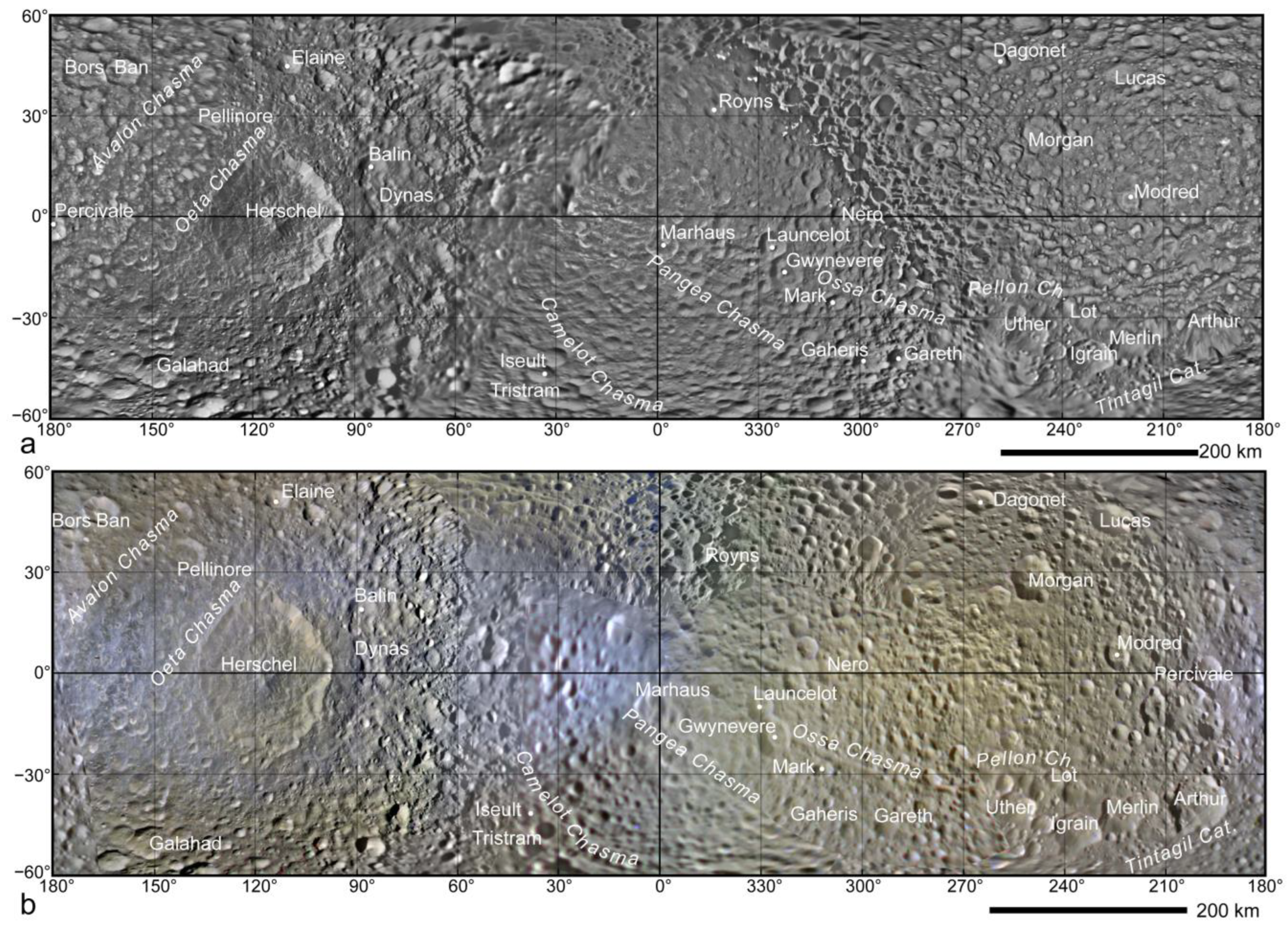
3. Results
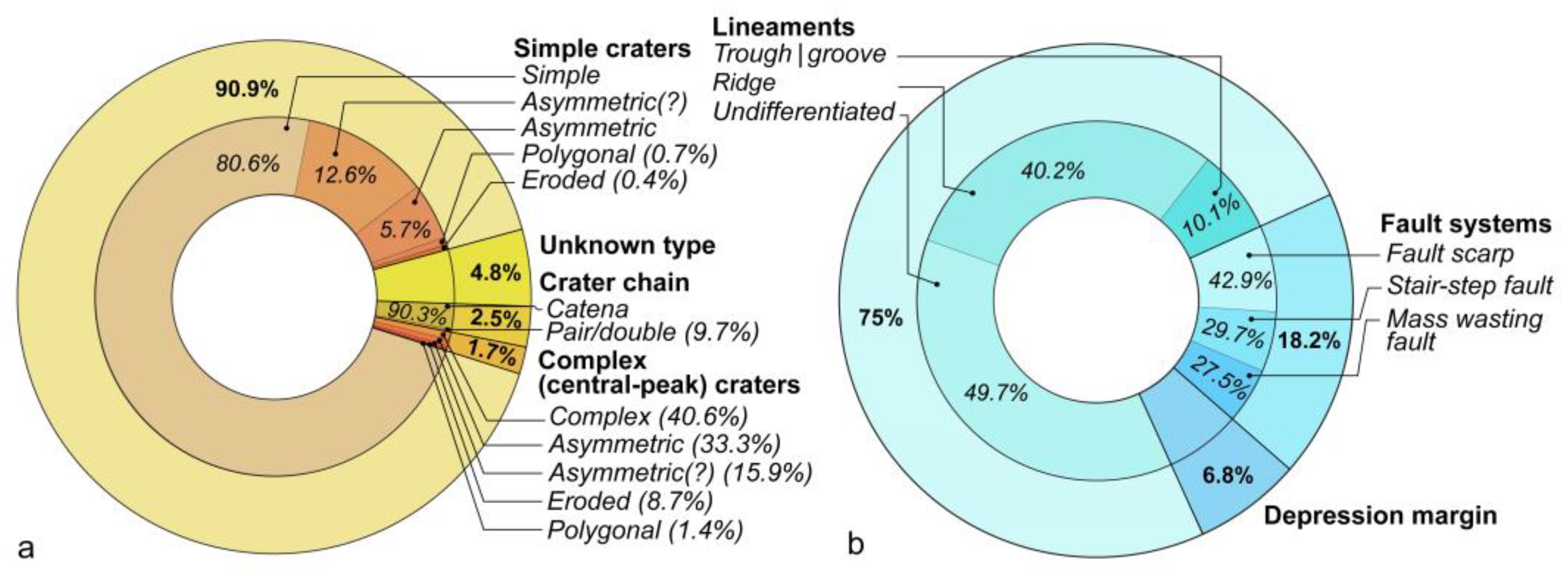
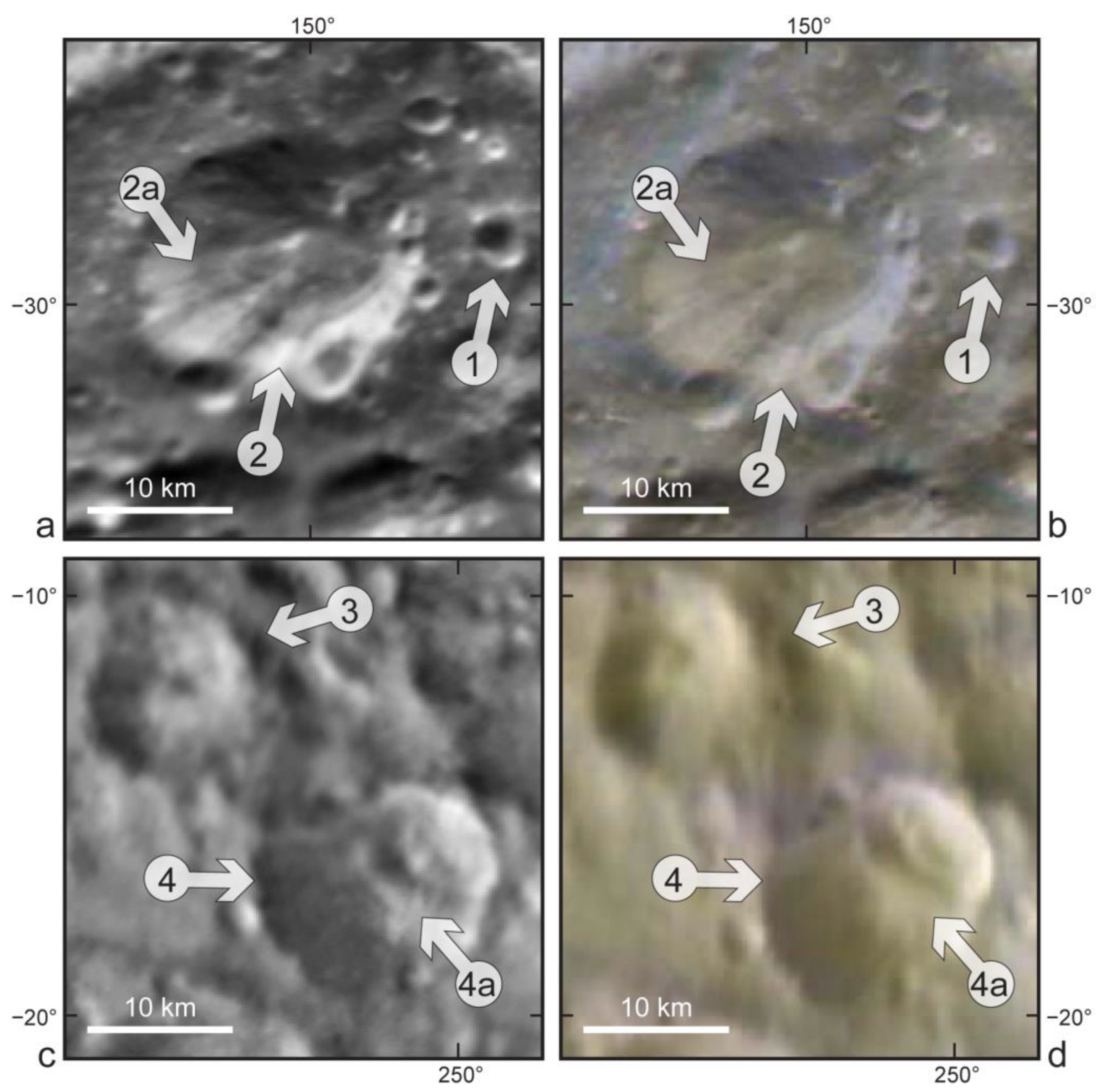
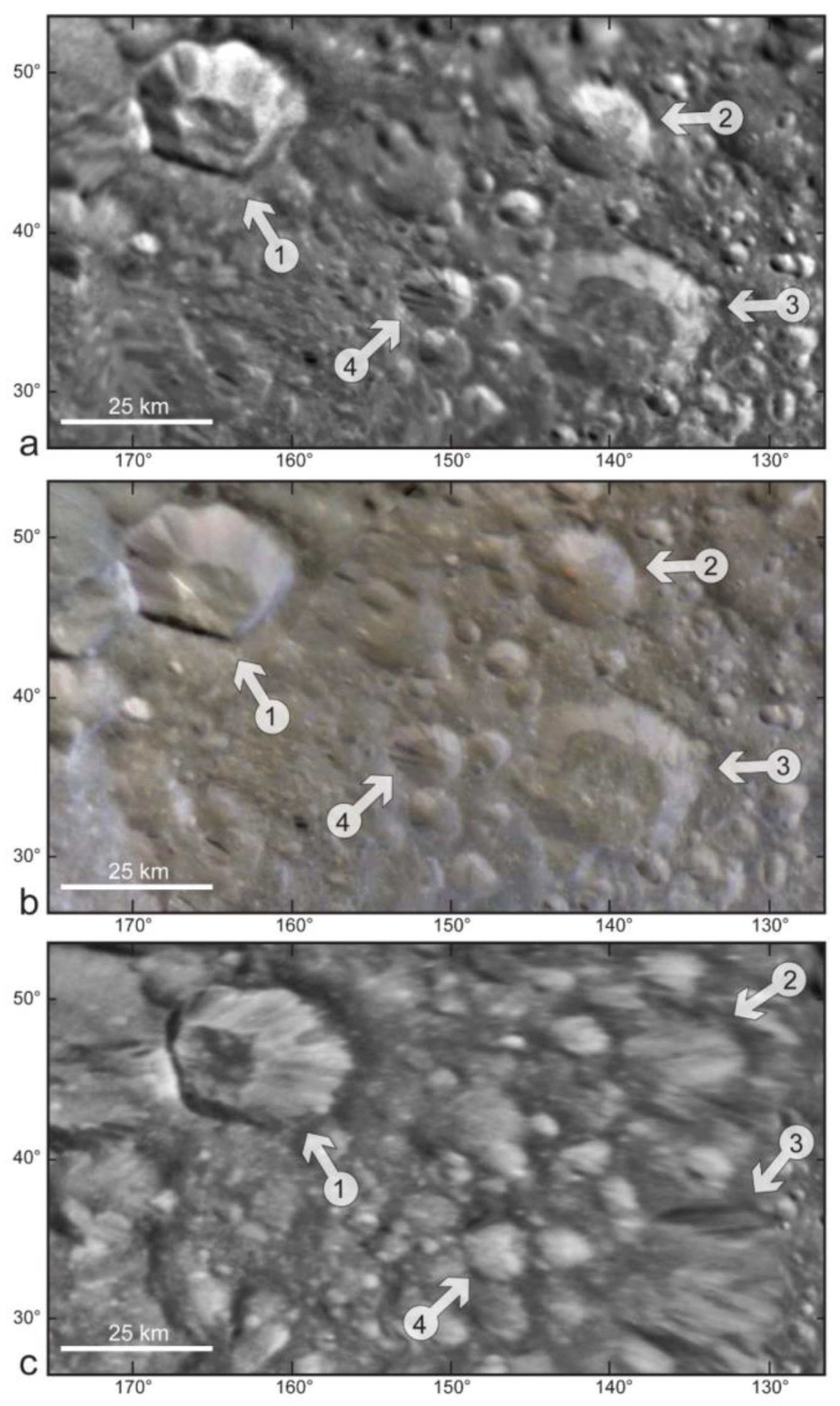
3.1. Impact Craters
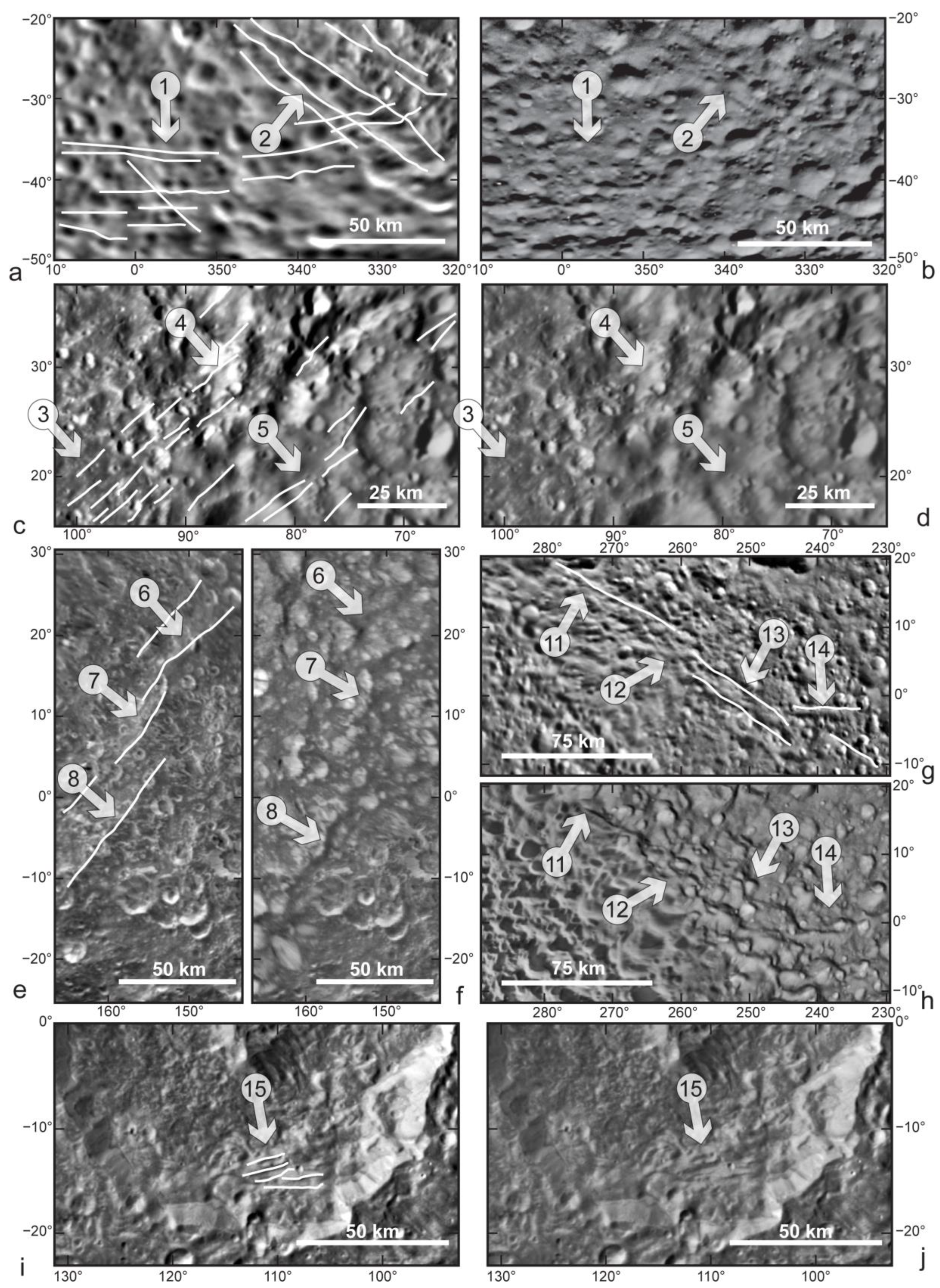
3.2. Potential Tectonic Features
4. Discussion—The Geological Map of Mimas (v1.0-2023)
4.1. Impact Crater Types and Their Potential in the Reconstruction of Geological Processes
4.2. The Distribution of Putative Tectonic Features and Their Origin
5. Conclusions
Author Contributions
Funding
Data Availability Statement
Acknowledgments
Conflicts of Interest
References
- Franceschelli, C.; Marabini, S. Luigi Ferdinando Marsili (1658–1730): A pioneer in geomorphological and archaeological surveying. In The Origins of Geology in Italy; Geological Society of America (GSA ) Special Papers, USA; Battista Vai, G., Glen, W., Caldwell, E., Eds.; Geological Society of America: Boulder, CO, USA, 2006; Volume 411. [Google Scholar] [CrossRef]
- Oldroyd, D. Maps as pictures or diagrams: The early development of geological maps. In Rethinking the Fabric of Geology; Geological Society of America (GSA) Special Papers, USA; Baker, V.R., Ed.; Geological Society of America: Boulder, CO, USA, 2013; Volume 502. [Google Scholar] [CrossRef]
- Hargitai, H.; Naß, A. Planetary Mapping: A Historical Overview. In Planetary Cartography and GIS. Lecture Notes in Geoinformation and Cartography; Hargitai, H., Ed.; Springer: Cham, Switzerland, 2019. [Google Scholar] [CrossRef]
- Hansen, C.J.; Esposito, L.; Stewart, A.I.F.; Colwell, J.; Hendrix, A.; Pryor, W.; Shemansky, D.; West, R. Enceladus’ water vapor plume. Science 2006, 311, 1422–1425. [Google Scholar] [CrossRef] [PubMed]
- Sparks, W.B.; Hand, K.P.; McGrath, M.A.; Bergeron, E.; Cracraft, M.; Deustua, S.E. Probing for evidence of plumes on Europa with HST/STIS. Astrophys. J. 2016, 829, 121. [Google Scholar] [CrossRef]
- Paganini, L.; Villanueva, G.L.; Roth, L.; Mandell, A.M.; Hurford, T.A.; Retherford, K.D.; Mumma, M.J. A measurement of water vapor amid a largely quiescent environment on Europa. Nat. Astron. 2020, 4, 266–272. [Google Scholar] [CrossRef]
- Hansen, C.J.; Esposito, L.W.; Colwell, J.E.; Hendrix, A.R.; Portyankina, G.; Stewart, A.I.F.; West, R.A. The composition and structure of Enceladus’ plume from the complete set of Cassini UVIS occultation observations. Icarus 2020, 344, 113461. [Google Scholar] [CrossRef]
- Hussmann, H.; Sotin, C.; Lunine, J.I. Interiors and Evolution of Icy Satellites. Treatise Geophys. 2007, 10, 509–539. [Google Scholar] [CrossRef]
- Nimmo, F.; Pappalardo, R.T. Ocean worlds in the outer solar system. J. Geophys. Res. Planets 2016, 121, 1378–1399. [Google Scholar] [CrossRef]
- Carr, M.; Belton, M.; Chapman, C.R.; Davies, M.E.; Geissler, P.; Greenberg, R.; McEwen, A.S.; Tufts, B.R.; Greeley, R.; Sullivan, R.; et al. Evidence for a subsurface ocean on Europa. Nature 1998, 391, 363–365. [Google Scholar] [CrossRef]
- Kivelson, M.G.; Khurana, K.K.; Russel, C.T.; Volwerk, M.; Walker, R.Y.; Zimmer, C. Galileo magnetometer measurements: A strong case for the subsurface ocean at Europa. Science 2000, 289, 1340–1343. [Google Scholar] [CrossRef]
- Saur, J.; Duling, S.; Roth, L.; Jia, X.; Strobel, D.F.; Feldman, P.D.; Christensen, U.R.; Retherford, K.D.; McGrath, M.A.; Musacchio, F.; et al. The search for a subsurface ocean in Ganymede with Hubble Space Telescope observations of its auroral ovals. J. Geophys. Res. Space Phys. 2015, 120, 1715–1737. [Google Scholar] [CrossRef]
- Porco, C.C.; Helfenstein, P.; Thomas, P.C.; Ingersoll, A.P.; Wisdom, J.; West, R.; Neukum, G.; Denk, T.; Wagner, R.; Roatsch, T.; et al. Cassini observes the active south pole of Enceladus. Science 2006, 311, 1393–1401. [Google Scholar] [CrossRef]
- Vincent, D.; Lambrechts, J.; Tyler, R.H.; Karatekin, Ö.; Dehant, V.; Deleersnijder, É. A numerical study of the liquid motion in Titan’s subsurface ocean. Icarus 2022, 388, 115219. [Google Scholar] [CrossRef]
- Bierson, C.; Nimmo, F. A note on the possibility of subsurface oceans on the Uranian satellites. Icarus 2022, 373, 114776. [Google Scholar] [CrossRef]
- Castillo-Rogez, J.; Weiss, B.; Beddingfield, C.; Biersteker, J.; Cartwright, R.; Goode, A.; Melwani Daswani, M.; Neveu, M. Compositions and interior structures of the large moons of Uranus and implications for future spacecraft observations. J. Geophys. Res. Planets 2023, 128, e2022JE007432. [Google Scholar] [CrossRef] [PubMed]
- Hansen, C.J.; Castillo-Rogez, J.; Grundy, W.; Hofgartner, J.D.; Martin, E.S.; Mitchell, K.; Nimmo, F.; Nordheim, T.A.; Paty, C.; Quick, L.C.; et al. Triton: Fascinating Moon, Likely Ocean World, Compelling Destination! Planet Sci. J. 2021, 2, 137. [Google Scholar] [CrossRef]
- Howell, S.M.; Pappalardo, R.T. NASA’s Europa Clipper—A mission to a potentially habitable ocean world. Nat. Commun. 2020, 11, 1311. [Google Scholar] [CrossRef] [PubMed]
- Leonard, E.J.; Patthoff, A.; Senske, D.A. Geological mapping of Europa at global and regional scales. In Planetary Geologic Mappers 2019; USGS Astrogeology Science Center: Flagstaff, AZ, USA, 2019; LPI Contrib. No. 2154, 12–14 June 2019, 7032.pdf; Available online: https://www.hou.usra.edu/meetings/pgm2019/pdf/7032.pdf (accessed on 17 November 2023).
- Collins, G.C.; Patterson, G.W.; Head, J.W.; Pappalardo, R.T.; Prockter, L.M.; Lucchitta, B.K.; Kay, J.P. Global Geologic Map of Ganymede; U.S. Geological Survey: Reston, VA, USA, 2013. [Google Scholar] [CrossRef]
- Crow-Willard, E.N.; Pappalardo, R.T. Structural mapping of Enceladus and implications for formation of tectonized regions. J. Geophys. Res. Planets 2015, 120, 928–950. [Google Scholar] [CrossRef]
- Stephan, K.; Jaumann, R.; Wagner, R.; Clark, R.N.; Cruikshank, D.P.; Hibbitts, C.A.; Roatsch, T.; Hoffmann, H.; Brown, R.H.; Filiacchione, G.; et al. Dione’s spectral and geological properties. Icarus 2010, 206, 631–652. [Google Scholar] [CrossRef]
- Lopes, R.M.C.; Malaska, M.J.; Schoenfeld, A.M.; Solomonidou, A.; Birch, S.P.D.; Florence, M.; Hayes, A.G.; Williams, D.A.; Radebaugh, J.; Verlander, T.; et al. A global geomorphologic map of Saturn’s moon Titan. Nat. Astron. 2020, 4, 228–233. [Google Scholar] [CrossRef]
- Schenk, P.M.; Beddingfield, C.B.; Bertrand, T.; Bierson, C.; Beyer, R.; Bray, V.J.; Cruikshank, D.; Grundy, W.M.; Hansen, C.; Hofgartner, J.; et al. Triton: Topography and geology of a probable ocean world with comparison to Pluto and Charon. Remote Sens. 2021, 13, 3476. [Google Scholar] [CrossRef]
- Jaumann, R.; Hiesinger, H.; Anand, M.; Crawford, I.A.; Wagner, R.; Sohl, F.; Jolliff, B.L.; Scholten, F.; Knapmeyer, M.; Hoffmann, H.; et al. Geology, geochemistry, and geophysics of the Moon: Status of current understanding. Planet. Space Sci. 2012, 74, 15–41. [Google Scholar] [CrossRef]
- Kramer, G. Origin, Geography, and Geology of the Moon. In Handbook of Lunar Base Design and Development; Eckart, P., Aldrin, A., Eds.; Springer: Cham, Switzerland, 2020. [Google Scholar] [CrossRef]
- Ashkenazy, Y. The surface temperature of Europa. Heliyon 2019, 5, e01908. [Google Scholar] [CrossRef]
- Greenberg, R.; Geissler, P.; Hoppa, G.; Tufts, B.R. Tidal-tectonic processes and their implications for the character of Europa’s icy crust. Rev. Geophys. 2002, 40, 1004. [Google Scholar] [CrossRef]
- Howell, S.M.; Pappalardo, R.T. Band formation and ocean-surface interaction on Europa and Ganymede. Geophys. Res. Lett. 2018, 45, 4701–4709. [Google Scholar] [CrossRef]
- Ligier, N.; Paranicas, C.; Carter, J.; Poulet, F.; Calvin, W.M.; Nordheim, T.A.; Snodgrass, C.; Ferellec, L. Surface composition and properties of Ganymede: Updates from ground-based observations with the near-infrared imaging spectrometer SINFONI/VLT/ESO. Icarus 2019, 333, 496–515. [Google Scholar] [CrossRef]
- Squyres, S.W. Surface temperatures and retention of H2O frost on Ganymede and Callisto. Icarus 1980, 44, 502–510. [Google Scholar] [CrossRef]
- Becker, H.N.; Florence, M.M.; Brennan, M.J.; Hansen, C.J.; Schenk, P.M.; Ravine, M.A.; Arballo, J.K.; Bolton, S.J.; Lunine, J.I.; Guillaume, A.; et al. Surface features of Ganymede revealed in Jupiter-shine by Juno’s Stellar Reference Unit. Geophys. Res. Lett. 2022, 49, e2022GL099139. [Google Scholar] [CrossRef]
- Howett, C.J.A.; Spencer, J.R.; Pearl, J.; Segura, M. Thermal inertia and bolometric bond albedo values for Mimas, Enceladus, Tethys, Dione, Rhea and Iapetus as derived from Cassini/CIRS measurements. Icarus 2010, 206, 573–593. [Google Scholar] [CrossRef]
- Filacchione, G.; D’Aversa, E.; Capaccioni, F.; Clark, R.N.; Cruikshank, D.P.; Ciarniello, M.; Cerroni, P.; Bellucci, G.; Brown, R.H.; Buratti, B.J.; et al. Saturn’s icy satellites investigated by Cassini-VIMS. IV. Daytime temperature maps. Icarus 2016, 271, 292–313. [Google Scholar] [CrossRef]
- Tyler, G.L.; Eshleman, V.R.; Anderson, J.D.; Levy, G.S.; Lindal, G.F.; Wood, G.E.; Croft, T.A. Radio science with Voyager 2 at Saturn: Atmosphere and ionosphere and the masses of Mimas, Tethys, and Iapetus. Science 1982, 215, 553–558. [Google Scholar] [CrossRef]
- Tajeddine, R.; Rambaux, N.; Lainey, V.; Charnoz, S.; Richard, A.; Rivoldini, A.; Noyelles, B. Constraints on Mimas’ interior from Cassini ISS libration measurements. Science 2014, 346, 322–324. [Google Scholar] [CrossRef]
- Noyelles, B. Interpreting the librations of a synchronous satellite–How their phase assesses Mimas’ global ocean. Icarus 2017, 282, 276–289. [Google Scholar] [CrossRef]
- Neveu, M.; Rhoden, A.R. The origin and evolution of a differentiated Mimas. Icarus 2017, 296, 183–196. [Google Scholar] [CrossRef]
- Rhoden, A.R.; Henning, W.; Hurford, T.A.; Patthoff, D.A.; Tajeddine, R. The implications of tides on the Mimas ocean hypothesis. J. Geophys. Res. Planets 2017, 122, 400–410. [Google Scholar] [CrossRef]
- Rhoden, A.R.; Walker, M.E. The case for an ocean-bearing Mimas from tidal heating analysis. Icarus 2022, 376, 114872. [Google Scholar] [CrossRef]
- Denton, C.A.; Rhoden, A.R. Tracking the evolution of an ocean within Mimas using the Herschel impact basin. Geophys. Res. Lett. 2022, 49, e2022GL100516. [Google Scholar] [CrossRef]
- Rhoden, A.R. Mimas: Frozen Fragment, Ring Relic, or Emerging Ocean World? Annu. Rev. Earth Planet. Sci. 2023, 51, 367–387. [Google Scholar] [CrossRef]
- Spencer, J.R.; Nimmo, F. Enceladus: An active ice world in the Saturn system. Annu. Rev. Earth Planet. Sci. 2013, 41, 693–717. [Google Scholar] [CrossRef]
- Dougherty, M.K.; Khurana, K.K.; Neubauer, F.M.; Russell, C.T.; Saur, J.; Leisner, J.S.; Burton, M.E. Identification of a dynamic atmosphere at Enceladus with the Cassini magnetometer. Science 2006, 311, 1406–1409. [Google Scholar] [CrossRef]
- Clark, R.N.; Curchin, J.M.; Jaumann, R.; Cruikshank, D.P.; Brown, R.H.; Hoefen, T.M.; Stephan, K.; Moore, J.M.; Buratti, B.J.; Baines, K.H.; et al. Compositional mapping of Saturn’s satellite Dione with Cassini VIMS and implications of dark material in the Saturn system. Icarus 2008, 193, 372–386. [Google Scholar] [CrossRef]
- Howett, C.J.A.; Spencer, J.R.; Hurford, T.; Verbiscer, A.; Segura, M. Thermophysical property variations across Dione and Rhea. Icarus 2014, 241, 239–247. [Google Scholar] [CrossRef]
- Jennings, D.E.; Tokano, T.; Cottini, V.; Nixon, C.A.; Achterberg, R.K.; Flasar, F.M.; Kunde, V.G.; Romani, P.N.; Samuelson, R.E.; Segura, M.E.; et al. Titan surface temperatures during the Cassini mission. Astrophys. J. Lett. 2019, 877, L8. [Google Scholar] [CrossRef]
- Niemann, H.B.; Atreya, S.K.; Bauer, S.J.; Carignan, G.R.; Demick, J.E.; Frost, R.L.; Gautier, D.; Haberman, J.A.; Harpold, D.N.; Hunten, D.M.; et al. The abundances of constituents of Titan’s atmosphere from the GCMS instrument on the Huygens probe. Nature 2005, 438, 779–784. [Google Scholar] [CrossRef]
- Schmedemann, N.; Neukum, G. Impact crater size-frequency distribution (SFD) and surface ages on Mimas. In Proceedings of the 42nd Annual Lunar and Planetary Science Conference, No. 1608, The Woodlands, TX, USA, 7–11 March 2011; p. 2772. Available online: https://www.lpi.usra.edu/meetings/lpsc2011/pdf/2772.pdf (accessed on 17 November 2023).
- Multhaup, K.; Spohn, T. Stagnant lid convection in the mid-sized icy satellites of Saturn. Icarus 2007, 186, 420–435. [Google Scholar] [CrossRef]
- Stooke, P.J. Geology of Mimas. Abstracts of the Lunar and Planetary Science Conference. In Proceedings of the Lunar and Planetary Science Conference, NASA Johnson Space Center, The Woodlands, TX, USA, 13–17 March 1989; Volume 20, p. 1069. Available online: https://adsabs.harvard.edu/full/1989LPI....20.1069S (accessed on 29 August 2023).
- Croft, S.K. Mimas: Tectonic Structure and Geologic History. In Reports of Planetary Geology and Geophysics Program, 1990; NASA: Washington, DC, USA, 1991. Available online: https://ntrs.nasa.gov/api/citations/19920001546/downloads/19920001546.pdf (accessed on 11 March 2023).
- Pike, R.J. Formation of complex impact craters: Evidence from Mars and other planets. Icarus 1980, 43, 1–19. [Google Scholar] [CrossRef]
- Croft, S.K. The scaling of complex craters. J. Geophys. Res. Solid. Earth 1985, 90, C828–C842. [Google Scholar] [CrossRef]
- Melosh, J.H.; Ivanov, B.A. Impact crater collapse. Annu. Rev. Earth Planet. Sci. 1999, 27, 385–415. [Google Scholar] [CrossRef]
- Pierazzo, E.; Melosh, H.J. Understanding Oblique Impacts from Experiments, Observations, and Modeling. Annu. Rev. Earth Planet. Sci. 2000, 28, 141–167. [Google Scholar] [CrossRef]
- Poelchau, M.H.; Kenkmann, T. Asymmetric signatures in simple craters as an indicator for an oblique impact direction. Meteorit. Planet. Sci. 2008, 43, 2059–2072. [Google Scholar] [CrossRef]
- Elbeshausen, D.; Wünnemann, K.; Collins, G.S. The transition from circular to elliptical impact craters. J. Geophys. Res. Planets 2013, 118, 2295–2309. [Google Scholar] [CrossRef]
- Krohn, K.; Jaumann, R.; Elbeshausen, D.; Kneissl, T.; Schmedemann, N.; Wagner, R.; Voigt, J.; Otto, K.; Matz, K.D.; Preusker, F.; et al. Asymmetric craters on Vesta: Impact on sloping surfaces. Planet. Space Sci. 2014, 103, 36–56. [Google Scholar] [CrossRef]
- Bérczi, S. Eroded Crater. In Encyclopedia of Planetary Landforms; Springer: New York, NY, USA, 2014. [Google Scholar] [CrossRef]
- Beddingfield, C.B.; Burr, D.M.; Tran, L.T. Polygonal impact craters on Dione: Evidence for tectonic structures outside the wispy terrain. Icarus 2016, 274, 163–194. [Google Scholar] [CrossRef]
- Wagner, R.J.; Neukum, G.; Schmedemann, N.; Hartmann, O.; Wolf, U. September. Crater chains, double and multiple craters on the satellites of Saturn: Morphology and stratigraphy. In Proceedings of the European Planetary Science Congress, Rome, Italy, 19–24 September 2010; p. 676. Available online: https://meetingorganizer.copernicus.org/EPSC2010/EPSC2010-676-1.pdf (accessed on 17 November 2023).
- Hargitai, H. Chasma, Chasmata. In Encyclopedia of Planetary Landforms; Springer: New York, NY, USA, 2014. [Google Scholar] [CrossRef]
- Bradák, B.; Nishikawa, M.; Gomez, C. A Theory about a Hidden Evander-Size Impact and the Renewal of the Intermediate Cratered Terrain on Dione. Universe 2023, 9, 247. [Google Scholar] [CrossRef]
- Öhman, T.; Aittola, M.; Korteniemi, J.; Kostama, V.P.; Raitala, J. Polygonal impact craters in the solar system: Observations and implications. Geol. Soc. Am. Spec. Pap. 2010, 465, 51–65. [Google Scholar] [CrossRef]
- Beddingfield, C.B.; Cartwright, R.J. Hidden tectonism on Miranda’s Elsinore Corona revealed by polygonal impact craters. Icarus 2020, 343, 113687. [Google Scholar] [CrossRef]
- Bradák, B.; Kimura, J.; Asahina, D.; El Yazidi, M.; Orgel, C. Introduction to Dione’s Wispy Terrain as a Putative Model Region for “Micro” Wilson Cycles on Icy Satellites. Remote Sens. 2023, 15, 5177. [Google Scholar] [CrossRef]
- Sekiguchi, N. On the fissions of a solid body under the influence of tidal force; with application to the problem of twin craters on the Moon. Moon 1970, 1, 429–439. [Google Scholar] [CrossRef]
- Zahnle, K.J.; Alvarellos, J.L.; Dobrovolskis, A.R.; Hamill, P. Secondary and sesquinary impact craters on Europa. Icarus 2008, 194, 660–674. [Google Scholar] [CrossRef]
- Bruesch, L.S.; Asphaug, E. Modeling global impact effects on middle-sized icy bodies: Applications to Saturn’s moons. Icarus 2004, 168, 457–466. [Google Scholar] [CrossRef]
- Moore, J.M.; Schenk, P.M.; Bruesch, L.S.; Asphaug, E.; McKinnon, W.B. Large impact features on middle-sized icy satellites. Icarus 2004, 171, 421–443. [Google Scholar] [CrossRef]
- Moore, J.M.; Ahern, J.L. The geology of Tethys. J. Geophys. Res. Solid. Earth 1983, 88, A577–A584. [Google Scholar] [CrossRef]
- Schenk, P.M. Crater formation and modification on the icy satellites of Uranus and Saturn: Depth/diameter and central peak occurrence. J. Geophys. Res. Solid. Earth 1989, 94, 3813–3832. [Google Scholar] [CrossRef]
- Prockter, L.M.; Patterson, W. Morphology and evolution of Europa’s ridges and bands. In Europa; Pappalardo, R.T., McKinnon, W.B., Khurana, K.K., Eds.; University of Arizona Press: Tucson, AZ, USA, 2009; pp. 237–258. [Google Scholar] [CrossRef]
- Dameron, A.C.; Burr, D.M. Europan double ridge morphometry as a test of formation models. Icarus 2018, 305, 225–249. [Google Scholar] [CrossRef]
- Quillen, A.C.; Giannella, D.; Shaw, J.G.; Ebinger, C. Crustal failure on icy moons from a strong tidal encounter. Icarus 2016, 275, 267–280. [Google Scholar] [CrossRef]
- Matsuyama, I.; Beuthe, M.; Hay, H.C.; Nimmo, F.; Kamata, S. Ocean tidal heating in icy satellites with solid shells. Icarus 2018, 312, 208–230. [Google Scholar] [CrossRef]
- Hay, H.C.; Matsuyama, I. Nonlinear tidal dissipation in the subsurface oceans of Enceladus and other icy satellites. Icarus 2019, 319, 68–85. [Google Scholar] [CrossRef]


| Satellite (a☾) | R⊕ | g⊕ | Tsurf (C°) | Surface Comp.; (geom. albedo) | Main Geological Features and Phenomena to Be Considered (Keywords) |
|---|---|---|---|---|---|
| Moon (1 a☾) | 0.27 | 0.17 | −183 (n), 106 (d) | Lunar regolith: rock and mineral fragments, impact and volcanic glasses, and agglutinates (0.12) | Various impact craters, crater chains (catenae), mare and lacus regions (plains formed by extensive melting and extrusion of basaltic rock), mountains (remaining rims of giant impacts), rilles, and moonquakes. Exosphere (tenuous atm.): He, Ar, Na, K, CH4, CO, CO2, and O2. |
| Europa (1.75 a☾) | 0.24 | 0.13 | −143 (max), −177 (e), −227 (p), −183 (m) | H2O ice, NaCl, colored areas: hydrated salts, SO42−; (0.67) | Lineaments, ridges, troughs, bands, banded plains, chaos terrains, microfeatures, and impact craters; sporadic plums, cryovolcanism, subsumption, and active cryotectonism. Extremely tenuous atmosphere: O2 and H2O. |
| Ganymede (2.78 a☾) | 0.41 | 0.15 | −183 to −113 | H2O ice, darkening agent; H2SO4 hydrate and salts (SO42−, Cl−), radiolytic processing; (0.43) | Old, highly cratered dark regions (~1/3 part of the surface) and bright grooved terrains, formed by tectonic and cryovolcanic processes (~2/3 part of the surface); cratered materials, basins, depressions, domes, palimpsest, furrows, and grooves. Tenuous, envelop atmosphere: O2, O3, and H2O. |
| Mimas (0.48 a☾) | 0.03 | 0.01 | ≤−185 (d) | H2O ice mainly (possibly from E ring), Appearance of NH3 ?; (0.6) | Heavily cratered, Herschel impact and the global-scale impact-related tectonic features; stealth subsurface ocean. No detectable atmosphere. |
| Enceladus (0.62a☾) | 0.04 | 0.01 | −185 to −163 (d), | Resurfacing by plume ices; H2O, CO2 ices, NH3 and “tholins” (iron rich nanograins); (1.0) | Geologically active icy moon, intense tectonism, ridges, troughs, scarps (younger provinces), cratered terrains (older regions), cryovolcanism, and plume activity. Tenuous atmosphere (more significant than other icy moons, except Titan): H2O, N2, CO2, CH4, and traces of simple organic molecules. |
| Dione (0.98 a☾) | 0.09 | 0.02 | −218 to −203 (n), −175 to −155 (d), | H2O and CO2 ices, NH3, ferrous iron-bearing mineral, radiolytic processing; (0.6) | Heavily cratered regions, catenae, fossae, chasmata; putative active cryotectonism: rifting, faulting, and potential subsumption; cryovolcanism. Thin gas envelop (exosphere): O2+, O2, and O3. |
| Titan (3.18 a☾) | 0.40 | 0.14 | −179 to −180 (a) | H2O, CH4, NH3 ices, hydrocarbons (in solid and liquid phase), rich in organic materials; (0.2) | Geological processes: impact cratering, pluvial, fluvial, and aeolian erosion and deposition, precipitation, dissolution, tectonism, and cryovolcanism. Thick, dense atmosphere: N2 (~95%), CH4 (~5%), and H2 (<1%); 1.35–1.6 p⊕. |
| Triton (0.92 a☾) | 0.21 | 0.08 | −235 | H2O, CH4, CO, CO2, HCN, and C2H6 ices; (0.76) | Very young surface, with various terrains: cantaloupe terrain(s), lineated terrains, etched plains, macular terrain, walled planitia, and bright lobate terrains; cavi and septa, ridges, scarps, knobs, depressions, mesa, paterae; plume activity, cryovolcanic features (smooth plains). Tenuous atmosphere: N2, CH4, and CO. |
Disclaimer/Publisher’s Note: The statements, opinions and data contained in all publications are solely those of the individual author(s) and contributor(s) and not of MDPI and/or the editor(s). MDPI and/or the editor(s) disclaim responsibility for any injury to people or property resulting from any ideas, methods, instructions or products referred to in the content. |
© 2024 by the authors. Licensee MDPI, Basel, Switzerland. This article is an open access article distributed under the terms and conditions of the Creative Commons Attribution (CC BY) license (https://creativecommons.org/licenses/by/4.0/).
Share and Cite
Bradák, B.; Okumi, M. The Geological Map of Mimas v1.0-2023. Geosciences 2024, 14, 25. https://doi.org/10.3390/geosciences14010025
Bradák B, Okumi M. The Geological Map of Mimas v1.0-2023. Geosciences. 2024; 14(1):25. https://doi.org/10.3390/geosciences14010025
Chicago/Turabian StyleBradák, Balázs, and Motoharu Okumi. 2024. "The Geological Map of Mimas v1.0-2023" Geosciences 14, no. 1: 25. https://doi.org/10.3390/geosciences14010025
APA StyleBradák, B., & Okumi, M. (2024). The Geological Map of Mimas v1.0-2023. Geosciences, 14(1), 25. https://doi.org/10.3390/geosciences14010025